
Abstract
This paper examines the intentionality behind the emergence of megaregion in Indonesia’s reinvented developmentalist state tradition. Illustrated by the case of Java, this paper explores the role of regional planning in facilitating megaregion emergence. It reveals that sectoral and ad hoc national planning policies, although not intentionally aimed to guide spatial development, implicitly promote the emergence of this megaregion. This is particularly registered in the construction of megaprojects aimed at increasing regional competitiveness through the improvement of interregional connectivity and facilitating exurbanization through the building of in-between cities.
Introduction
The recent resurgence of academic interest in intercity and interregional scales of urban formation suggests that this age may be a specifically megaregion moment. Recent works have advanced distinction between the likes of morphology and functioning of megaregions (Harrison and Hoyler 2015; Yingcheng Li and Phelps 2018; Ross 2009) and celebrated both the territorial and relational economic geography of megaregions (Florida, Gulden, and Mellander 2008; Yingcheng Li and Phelps 2019). Much of the extant economic geography literature focuses on the morphology and functioning of polycentric megaregions in Europe and North America as the unintended expression of economic processes even if there are different trajectories by which such regions form (Burger and Meijers 2012; Yingcheng Li and Phelps 2018). Nevertheless, in addition to these perspectives, which emphasize megaregions as the unintended expressions of uncontrolled urbanization, perspectives from urban political geography and urban planning observe a greater measure of intention in the emergence of megaregions (Innes, Booher, and Di Vittorio 2010; Schafran 2014).
The developmental state tradition—its post-developmental residue or partial likeness—found across many East Asian countries might be instructive in better understanding the intentionality found in the trajectories of megaregional development in this part of the world. 1 Developmentalism points to the proactive role of the state and planning in the formation and growth of megaregions (Su et al. 2017; Wu 2016; Wu and Zhang 2007; Ye 2013). However, such a strong and consistent role of the state is not always found in some Southeast Asian countries. Indonesia is the largest Southeast Asian country—one whose urban and infrastructure transformation has long been shaped by the private sector but also periodically and inconsistently by the sometime developmentalist vision of the state (Davidson 2015; Warburton 2016).
The literature on regional urbanization in Java has long focused on mega-urbanization, especially referring to the merging of Jakarta and Bandung metropolitan areas and the extension of the Surabaya Metropolitan Area into its rural-urban (desakota) hinterlands and adjacent cities and towns (Adair 2007; Firman 2017; Forber 1997; Jones and Douglass 2008; McGee 1991). 2 There have been few studies aimed at building a better understanding of regional urbanization emerging at the larger scale of megaregional spaces through the merging and interconnection of these two main mega-urban regions. This island-scale urban formation may date back to the early nineteenth century during the Late Dutch colonial rule (Nas 2002). However, the literature on Java’s contemporary urbanization tends to stress the demographic figures and physical forms (Jones 2018) and, thus, is unable to show the functional emergence of any megaregion and, furthermore, explain the intentionality behind its development.
In this paper, we explore the extent to which a perspective based on the intentionality of regional-scale urbanization can be helpful in tracking the trajectories of megaregion development in Java. The main objective is to explain the role of regional planning policy in facilitating the emergence of megaregions. This paper contributes to theories of state rescaling (Brenner 1998) by adding a specifically intermediate category of institutionalization lying somewhere between the weak intentionality implied in expressionist, economic geographical accounts and the strong versions of intentionality found in urban political and planning accounts (Jonas 2020; Wu 2016; Wu and Zhang 2007). It also contributes specifically to discussions surrounding the promotion of regional-scale urbanization in Indonesia, especially in Java, emphasizing the transformation of the North Coast (in Indonesian language popularly called Pantai Utara Jawa or abbreviated to Pantura) into a megaregion.
This article is presented in several parts. Following this introduction, the conception of megaregion development is reviewed by comparing and integrating morphological, functional, and intentional perspectives. Following brief notes on methodology and regional urbanization trend in Java, relevant regional plans and policies designed by the central government are identified. The first analysis stresses the extent to which policies institutionalize the issue of global competitiveness as the common trigger for megaregion emergence. Illustrated by the cases of the Trans Java Expressway, Jakarta-Bandung High-Speed Train (HST), and Kertajati Aerocity, the last part of the analysis assesses the implementation of these policies and their implications for the formation and functioning of the megaregion. The paper then discusses our findings and finally presents suggestions for future research and some of the planning policy implications that emerge from the findings.
Megaregion Emergence in Comparative Perspectives
Scholars increasingly have paid attention to the megaregion as a nationally and internationally important economic unit within the new urban frontier of globalized economies (Harrison and Hoyler 2015). Some claim that such large spatial forms can enhance the external efficiency of clusters and meta-clusters of advanced urban economic activities and, thus, help them to better compete on the global stage (Faludi 2009)—although the evidence here is rather mixed. As a result, some works have placed considerable attention on the external linkages and connectivity of megaregions as national growth centers and the main constituting element of global urban constellations. This external connectivity can be manifested in the unusual scale and density of economic linkages (large clusters of innovative, high-tech, and knowledge-based industries), large-infrastructure networks (large-scale road and transportation projects), and regional ecological connectivity (watersheds) (Florida, Gulden, and Mellander 2008; Hagler 2009; Ross 2009; Wheeler and Hull 2011). While acknowledging this important role of megaregional space as the “hub” or “hinge” of national economies, Yingcheng Li and Phelps (2017, 3) also highlight the strategic role of the Yangtze River Delta (YRD) Region as “an incubator of new trends, knowledge, and innovation” emerging within the delineated region.
Conceptualization of megaregion emergence has three analytical strands: the morphological view, the functionalist view, and what we here refer to as the intentionalist view. First, while Gottmann’s origination of the megalopolis idea contained a discussion of the functioning of this urban formation as an incubator and hinge, subsequent works on North American megaregion have tended to focus primarily on the morphological features emphasizing the physical expression manifested in the forms of large urbanized area (Hagler 2009; Lang and Dhavale 2005). From this perspective, a megaregion consists of a “network of metropolitan centers and their surrounding areas that are spatially and functionally linked through environmental, economic, and infrastructure interactions” (Ross 2009, 1).
Meanwhile, key literature on Western European megaregions primarily focuses on capturing the functional coherence with which economic activities are integrated, especially by way of knowledge and capital flows (Hall and Pain 2006; Hoyler, Kloosterman, and Sokol 2008; Reades and Smith 2014; Taylor et al. 2009). Given the importance of this invisible network, megaregional space may spread along traffic and commuter corridors. The new networked urban region contains a cluster of cities in a functional division of labor, connected by flows of people, goods, and information along motorways, high-speed rail lines, telecommunication systems, and international airports (Hall and Pain 2006; Kunzmann 1996).
Both morphological and functionalist views introduced above appear to naturalize the formation of megaregions. They significantly disregard the extent to which government intervention may be involved—including the manner in which some such regions have been sutured together from below as a result of intergovernmental cooperation (Wachsmuth 2017). They tend to neglect the fact that in most countries—including liberal market economies—spatial transformations can be complex processes in which the state plays a unique role in intermediating local and global interests and forces. This is especially true across East Asia, where the efforts of national states are often joined by those of local states in the conscious imagining and planning of megaregions (Hudalah et al. 2019; Jonas 2020; Su et al. 2017; Wu 2016; Wu and Zhang 2007). Therefore, although megaregion boundaries may not necessarily reflect political and administrative jurisdictions, East Asian cases depict megaregions as an intentional (consciously imagined, planned, and, to a greater or lesser extent, implemented) process of urban rescaling influenced by government policy and intervention. Thus, Tan (2017) considers megaregion formation as a multilevel governance process. In China, for instance, major cases such as Pearl River Delta (PRD) and YRD indicate that active engagement of government through carefully planned large-scale regional and infrastructure development policies and multilevel governance strategies has been an important factor driving the emergence of a highly performing megaregion (Yi Li and Wu 2013; Yang, Song, and Lin 2014; Ye 2013).
In reality, of course, these three perspectives are not mutually exclusive. They are inseparable from and interlinked with each other in explaining the long-term historical development of a megaregion. In certain stages of their development, many individual megaregions are revealing of the merits of each of these perspectives. Eventually, an integrated, multiperspectival, approach to understanding megaregion emergence is needed given that megaregions are complex and have typically evolved over long periods (Schafran 2015) and given that there are likely important, if not always consistent, feedback relationships between the morphology, the functioning, and the policy intentions associated with any given mega-urban region (Phelps 2019).
However, it is important for this paper to focus on intentional and policy perspectives since these are relevant for investigating the emergence of megaregional form and flow in the developing and transitional country context where the role of the state is still influential in coordinating urban development. Given the complexity of the geographical and historical context of East Asia, the policy approach might usefully be subdivided further to reveal qualitatively different planned initiations of megaregions. In light of theories of state rescaling, we translate these qualitative intentions into different categories of the hollowing out of the state as the result of glocalization and restructuring (Swyngedouw 2004). The hollowing out of the state can be differentiated into vertical rescaling (localization–nationalization–internationalization) and horizontal rescaling (statization–partnership–privatization) (Jessop 1997; Swyngedouw 2000).
As an example of statization in the face of localization, the state and planning have been spatially pervasive (explicit) and relatively consistent over time in the intentional formation of megaregions in China (Jonas 2020; Wu 2016; Wu and Zhang 2007). Here, extensive patterns of urbanization have seen enlargements of historic cities through annexation and the development of new districts and special economic zones (SEZs) and the planned aggregation of multiple city-regions into and redistribution of some urban functions across mega-urban regions (Yeh and Chen 2020). Elsewhere in East Asia, the intentionality of the state apparent within megaregion formation as part of developmental state planning has had mixed effects. While megaregional morphological and functional realities have long been a part of Japan’s (post)developmentalism, explicit spatial policy appeals to the megaregion scale have been tenuous (Hanes 1993). Similarly, policy designed to engineer a stronger measure of outer suburban polycentricity in greater Tokyo has largely failed (Phelps and Ohashi 2018). We argue that the strong sense of intentionality of the state found in the Chinese situation might be contrasted with that of Indonesia, in which a more ad hoc and spatially selective, limited, and indirect (implicit) role of the state has become the norm. In other words, while downward state rescaling has characterized China’s transition to megaregionalization, the Java case, as shown in the next sections, seems to be more complex with a higher degree of upward and horizontal state rescaling processes, signified by sectoral and ad hoc nationalization and public–private partnership.
Method
Our analysis considered two aspects of intentionality: planning and implementation. We analyzed regional plans formulated by the central government in the past decade aimed at coordinating urban and regional development in Java and containing policy directives that intentionally or unintentionally have the potential to promote megaregionalization in Java. We conducted a content analysis on development, and spatial and sectoral plans and policies carried out at island or inter-mega-urban geographical scales. In Indonesia, these plans are coordinated by the national government. We evaluated the role of the national plans using three broad criteria for megaregion development: extra- or inter-mega-urban nature in form or location; functional dependence to mega-urban core, contribution to the national economies, and global economic links; or competitiveness (Faludi 2009; Florida, Gulden, and Mellander 2008).
Meanwhile, the regional plans’ implementation became the focus of the second stage of analysis. We assessed the plans’ effectiveness in shaping the form, function, and competitiveness of megaregion using illustrative case studies of megaprojects listed in the presidential decree on national strategic projects (PSN). PSN has become the most comprehensive implementing policy to expedite the realization of key planning items affecting regional urbanization in Java. We focused the analysis on completed or ongoing glocally linked megaprojects operating at inter-mega-urban (or megaregional) scales. We consequently excluded projects under planning discussion or in the initial implementation, located exclusively within the boundaries of established metropolitan regions (such as inner-city toll roads, Light Rail Transit System [LRTS], and mass rapid transit system [MRTS]), and having limited implications for regional urbanization (water, energy, and telecommunication). As a result, the three case studies of Trans Java Expressway, Jakarta-Bandung HST, and Kertajati Airport and Aerocity were selected (see Figure 1).
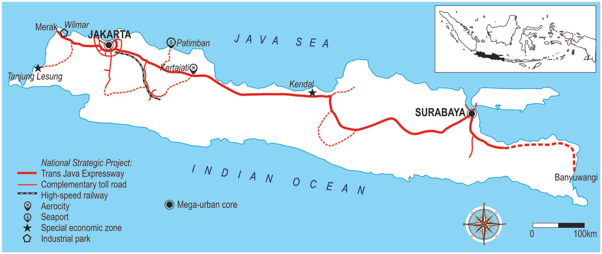
National strategic projects in Java.
Regional Urbanization in Java
Home for about 68 percent of Indonesia’s urban population, Java is the most densely populated island in Southeast Asia. During the period of 2000–2010, the urban population grew enormously at about 12 percent from 58.9 million to 80.0 million (Firman 2017). During the same period, the proportion of the urban population increased from 48.7 to 60.8 percent. Java’s urban population and industrial economies have been concentrated along the North Coast. This 1,200 km corridor—“the longest city in the world”—mainly connects the mega-urban regions of Jakarta and Surabaya (Nas 2002, 721). The North Coast has a gross domestic product (GDP) value of nearly IDR 2,000 trillion (US$135 millions) or contributes to 26.5 percent of the national GDP (Imran 2016).
About 75 percent of freight flows and 65 percent of passenger flows in Java are concentrated in the North Coast (Mulyono 2016). The national transport origin-destination survey conducted by the Indonesia Ministry of Transportation (2011) reveals that more than 5 million people travel and 13 million goods are conveyed between Jakarta and Surabaya, the two largest cities constituting the North Coast. This megaregional-scale interaction represents the second-highest interregional interaction after that between the metropolitan cores of Jakarta and Bandung (see Figure 2).
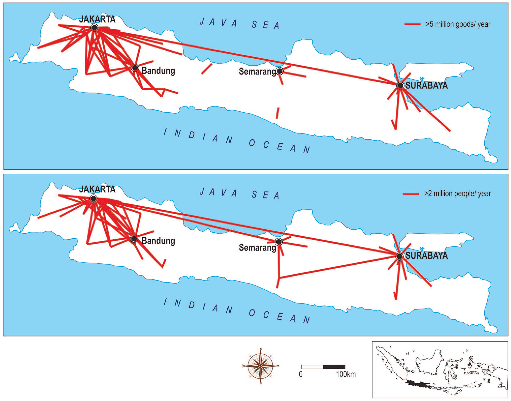
Freight and passenger flows in Java.
Manufacturing has become the backbone of Java’s economies. The government reported that more than 80 percent of country’s GDP contribution from the appliance and machinery sector comes from the island (Government of Republic of Indonesia 2011). Foods and beverages industries contributed to 22.3 percent of the total manufacturing production of the island—the second largest after machineries. The same industries adsorbed most laborers, numbering 3.6 million in 2010. It was followed by textile industries, which directly employed more than 1.3 million people throughout the country.
The building of intermetropolitan and inter-mega-urban connectivity in Java dates to the Dutch colonial time and the construction of the Great Mail Road (Grote Postweg in Dutch and Jalan Raya Pos in Indonesian) between 1811 and 1813. This 1,000 km road along the North Coast (Pantura) covers the length of the island, passing through the mega-urban cores of Jakarta and Surabaya. It has transformed into the busiest and most developed road network in Indonesia, transporting more than 90 percent of cargo between Jakarta and Surabaya (Sandee 2016), becoming “one prolonged, urbanized area” (Nas 2002, 721).
In the era of democracy and decentralization of government since the fall of Suharto, regional plans have become more numerous. Simultaneously, they have struggled to gain traction on actual patterns of development, notably as a result of difficulties in funding key pieces of infrastructure and in effective implementation but also partly because local governments and local legislative bodies often object to interlocal government initiatives at metropolitan, mega-urban, or megaregion scales (Hudalah, Firman, and Woltjer 2014). Local governments have been pursuing their own local development agendas, which only sometimes overlap with the national agenda. This has resulted in the post-suburbanization phenomenon (Phelps and Wood 2011; Phelps, Wood, and Valler 2010) within the urban system, where the fringe areas have become partly independent from the core city (Hudalah and Firman 2012).
Regional Planning in Java
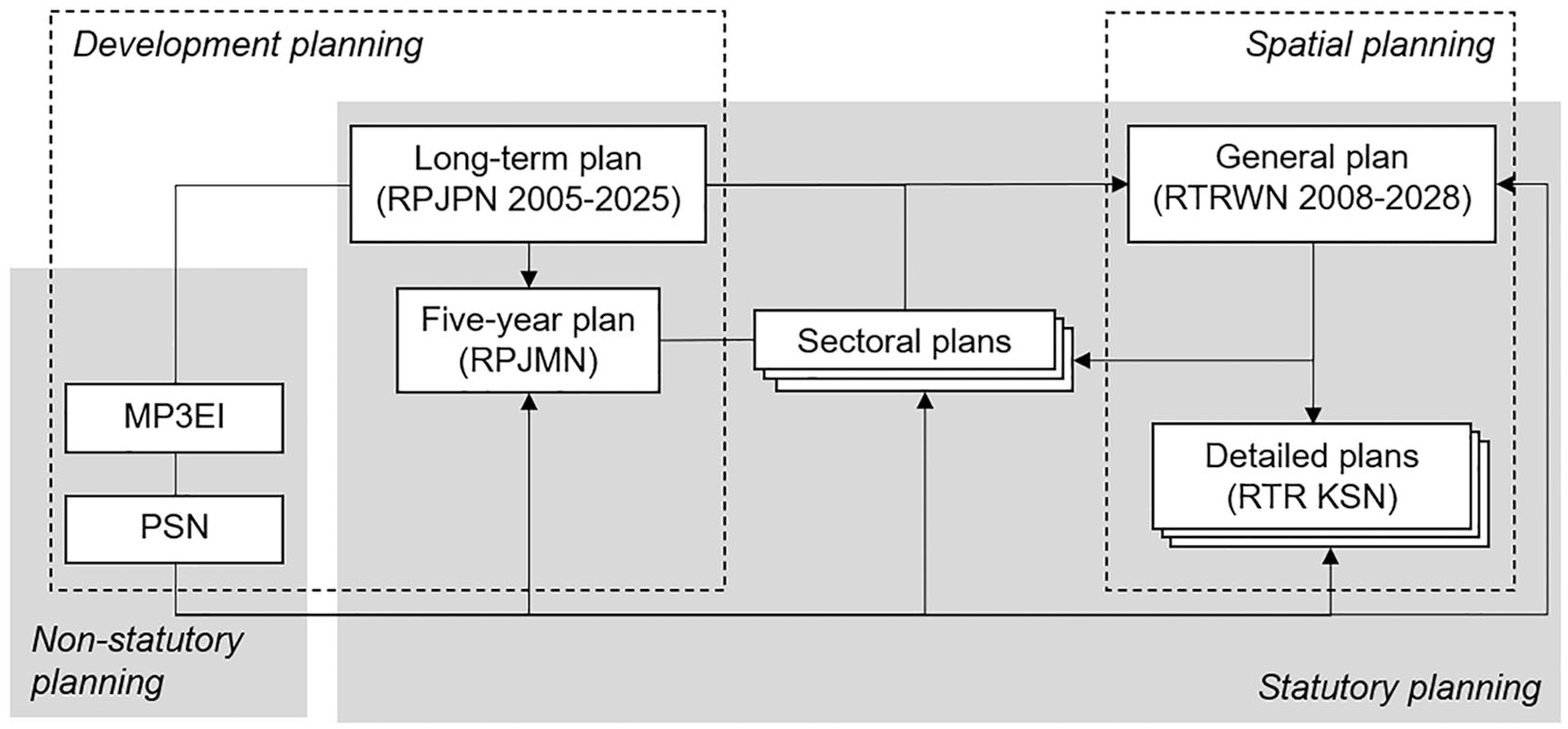
As Indonesia’s planning seeks to be an integrated-comprehensive system (Hudalah and Woltjer 2007), regional plans are prepared periodically and hierarchically at all tiers of government. As presented in Figure 3, from a policy regime perspective, the nationally coordinated regional plans can be clustered into development plans, spatial plans, and sectoral plans. Considering their time frame, national development plans can be ordered into National Long-Term Development Plan (RPJPN), National Five-Year Development Plan (RPJMN), and National Annual Development Plan (RKP). The figure implies that the national long-term development plan coordinated by the Ministry of National Development Planning is the foundation for all other plans as it is the only plan enacted in the form of law. Meanwhile, coordinated by the Ministry of Land and Spatial Planning, national spatial plans directly related to Java’s urban constellations consist of National General Spatial Plan (RTRWN 2008–2028) and metropolitan spatial plans (RTRW KSN Metropolitan). In parallel with these, several ministries—such as the Ministry of Industry—build their own sectoral planning regimes. In addition to the statutory plans formally enacted by legislative bodies or required by law, over the past decade, successive Presidents have enacted several nonstatutory or ad hoc plans such as Master Plan for the Acceleration and Expansion of Indonesian Economic Development (MP3EI) and PSN, which act as supplementary and implementing documents to the long-term development plan.
National planning systems in Java.
Statutory planning: Development planning, spatial planning, and sectoral planning
Prepared during the Asian Financial Crisis recovery, the first long-term development plan (RPJPN 2005–2025) has the objective to assist the country to “catch the lagging behind and have an equal position and strong competitiveness in the international stages.” For this reason, the plan particularly highlights the country’s reliance on “globally competitive manufacturing industries that drive the economies,” which is primarily located in Java (Government of Republic of Indonesia 2007). In addition to quality human resource and technological readiness, another key indicator for global competitiveness found in the plan is the availability of “reliable and integrated transport infrastructure.”
Regardless of its function to translate the long-term development plan into physical terms, the spatial planning regime has not explicitly addressed the urban competitiveness issue emerging at the Java megaregional scale. The largest urban agglomeration unit recognized in the national general spatial plan (RTRWN 2008–2028) is the metropolitan area (kawasan metropolitan). The RTRWN defines a metropolitan area (kawasan metropolitan) as a functional urban region (kawasan perkotaan) normally consisting of a metropolitan core and its commuting hinterland (Government of Republic of Indonesia 2008). The metropolitan core is a very large city with a million population or more that serves as the engine of growth for its surrounding hinterland. About fourteen Indonesia’s metropolitan cores (kota metropolitan) represent only 3 percent of the total number of districts/municipalities but contribute to 30 percent of the national GDP (Ministry of Public Works 2006). Due to this significant contribution for the national economies, the latest revision of the RTRWN has identified four metropolitan areas in Java as part of “the national strategic areas for economic growth purposes” (Government of Republic of Indonesia 2017), including Jabodetabekpunjur or Jakarta Metropolitan Area (7,062.47 km2), Gerbangkertasusila or Surabaya Metropolitan Area (5,925.84 km2), Cekungan Bandung or Bandung Metropolitan Area (3,411.35 km2), and Kedungsepur or Semarang Metropolitan Area (4,298.43 km2). Furthermore, the central government gradually prepares supplementary detailed spatial plans for each metropolitan area in the form of spatial plan for metropolitan national strategic area (RTR KSN). The metropolitan plan has the function to coordinate metropolitan area-wide planning initiatives and programs in urban, economic, infrastructure, and environmental sectors.
Actually, the RTRWN initially introduced a larger urban unit termed kawasan megapolitan or “megapolitan area” to denote a functional urban system constituted by two or more metropolitan areas, which corresponds with McGee’s mega-urban region conception (McGee 1991; McGee and Robinson 1995). However, the plan has not elaborated on the planning conception, strategies, and programs for mega-urban regions, let alone the larger scale of megapolitan region.
Similarly, several sectoral planning policies propose functional areas and growth centers with national importance. For instance, in 2015, the Ministry of Industry in their Master Plan of National Industrial Development (RIPIN 2015–2035) delineates Industrial Growth Region (WPPI) as “a region designed for industrial-based development with the potential utilization for regional resources through the strengthening of industrial infrastructure and connectivity with strong economic linkages.”
As depicted in Figure 4, the area coverage of the industrial growth region (WPPI) can be larger than the metropolitan area (KSN). Its location and boundaries may also overlap those of metropolitan areas (Jakarta, Semarang, and Surabaya). This sectoral planning policy was not intentionally prepared to guide spatial development, but it does contribute implicitly to the integration of neighboring metropolitan areas such as Jakarta and Bandung into a single spatial unit of mega-urban region. Moreover, all delineated industrial growth regions and their surrounding hinterlands tend to agglomerate along the North Coast, forming an island-based “economic corridor” (Government of Republic of Indonesia 2011).
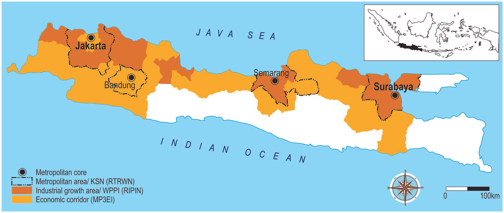
Geographical units and boundaries of regional planning areas in Java.
Nonstatutory planning and policy: MP3EI and PSN
In 2011, President Yudhoyono attempted to identify national strategic infrastructure projects and integrate them into a broader nonstatutory development planning framework called the MP3EI (2011–2025). Echoing the long-term development plan’s vision, the government deemed MP3EI “very important to provide the driving force and lift for Indonesia’s competitiveness.” The core element of this master plan was to divide the country into six economic corridors based on the main islands, including Java. Agglomeration of economic growth centers and their connectivity are the key elements of MP3EI’s economic corridor for which various megaprojects in the transport, energy, and water sectors and SEZs in industrial and leisure sectors are listed and prioritized.
Java Economic Corridor encompassed the whole length of the North Coast connecting Greater Jakarta-Bandung and Greater Surabaya. It was aimed at becoming the country’s industrial and service sector driver. The industrial sector was particularly prioritized in the master plan because Java is the most industrialized main island in Indonesia (Government of Republic of Indonesia 2011). The development of SEZs and industrial clusters in the corridor was emphasized, focused on food and beverages, textiles, and transport equipment sectors. Other strategic sectors include shipping, telematics, and weaponry. To improve the corridor’s connectivity, the master plan also outlined key megaprojects, including airports, seaports, railways, toll roads, floods defense, and drinking water systems.
Megaprojects and SEZs are both often considered key tools to improve a nation’s competitiveness (Kennedy 2015; Zeng 2010). President Joko Widodo’s coordinating ministry through the Committee for Development Acceleration of Priority Infrastructure also maintained that “the improvement of a nation’s competitiveness proportionally corresponds with its growth prospect, in which infrastructure is the driver of economic development” (KPPIP 2015). Therefore, through the Presidential Decree No. 3/2016 on the Acceleration of PSN Implementation, he attempted to boost the realization of large-scale infrastructure projects, most of which have been identified previously in the MP3EI. PSN is a collection of megaprojects implemented by government and/or business entities considered to increase economic growth, improve community welfare, and stimulate regional development. The presidential decree has been revised annually and currently aims at more than 250 megaprojects, including infrastructure projects such as expressway and toll roads, railways, airports and seaports, and SEZs.
Illustrative Case Studies of Regional Plans and Policies’ Implementation
Trans Java Expressway
Aiming to resolve congestion along the Great Mail Road, in 1975, the central government started the construction of Trans Java Expressway. Built in parallel with the mail road, the expressway is designed to cut across the island’s north coast, the country’s demographic and industrial center. This 1,200 km expressway stretches from Merak (northwestern coast) through the mega-urban cores of Jakarta and Surabaya to Banyuwangi (southeastern coast).
The 1997 Asian Financial Crisis and the following political upheaval effectively suspended the completion of the Trans Java Expressway. A decade of underinvestment caused the island to suffer a major infrastructure deficit. In the 2000s, the rates of infrastructure spending across the country were no more than 4 percent of GDP, while they were above 7 percent before the crisis (Sandee 2016). Poor connectivity emerged as a major challenge to boosting the global competitiveness of the industries located along the economic corridor. As an illustration, passing through the congested Great Mail Road, Jakarta-Surabaya travel times were more than a day. Furthermore, the costs of transporting a container from industrial zones to international seaports in Java were nearly 60 percent higher than those in Malaysia, causing 10 percent delivery failures of Java’s exports (Sandee 2016).
As 93 percent of freight and passengers in Java are transported through road (Mulyono 2016), President Joko Widodo ordered the expedited construction of the expressway’s remaining sections via a Presidential Decree, arguing its importance to generating significant employment and economic welfare increases in the post-2008 global economic slowdown. It also improves the country’s economic competitiveness in the face of regional free-trade agreements under the banner of the ASEAN Economic Community (AEC). The presidential decree privileges the implementation of projects such that, in several cases, national, regional, and local planning bodies were forced to revise their respective formal spatial plans.
Widodo’s approach to infrastructure development marked a return to a more proactive or developmental role for government as previously exerted differently during Suharto’s New Order. In this new developmentalism, the government leads infrastructure development to foster economic development (Warburton 2016). Widodo focused on short-term strategies for pushing his infrastructure agenda, such as ease of regulation, land acquisition expedition, and tariff subsidy (Zuna and Retapradana 2017). Other crucial strategies included “expanding the budgets of line ministries and accelerating their disbursements, injecting large amounts of budgetary funds into the state-owned infrastructure sector, and ‘assigning’ (penugasan) important projects to these well-funded state-owned enterprises (SOEs)” (Ray and Ing 2016, 10). Major state-owned companies with concessions—such as PT Jasa Marga (persero) Tbk and PT Waskita Karya (persero)—aggressively established joint venture companies, built strategic financial cooperation with state-owned banks, and enlarged their shares in the concessions.
As a result, by 2019, about 1,000 km of the planned main expressway has been completed. Cutting the travel time between Jakarta and Surabaya by about ten hours (Mulyono 2016), it is expected that the expressway could ease interregional traffic and, thus, improve the corridor’s competitiveness (Prasetyo and Djunaedi 2019). As tolls are still considered too expensive, the immediate impact of the newly built expressway on freight flow remains to be seen. Nevertheless, the impact on local economies and local government fiscal positions is emerging (Prasetyo and Djunaedi 2019). Furthermore, the toll road extensions are connecting the corridor with special economic zones (such as Tanjung Lesung Tourism Resort and Kendal Industrial Park) as the new growth centers located beyond the established boundaries of Jakarta-Bandung and Greater Surabaya mega-urban regions.
Jakarta-Bandung High-Speed Train
In line with President Joko Widodo’s vision for a more competitive Indonesia, the push to develop South East Asia’s first cutting-edge HST across Java was first mooted in 2008. Previously, as indicated in the Master Plan for the National Railway System 2010–2030, the planned HST was nearly 1,000 km long and aimed to further improve the connection between Jakarta and Surabaya. However, due to higher costs and risks and uncertain demands, the government decided to reroute the trainline and first develop a shorter one, later named Jakarta-Bandung HST, with possible future extension to Kertajati Airport and Surabaya (Salim and Negara 2016). Diverting traffic on the already crowded toll road and regular rail line, this 143.2 km high-speed line was claimed to be able to strengthen the connection between Jakarta and Bandung (Yachiyo Engineering Co. Ltd. and Japan International Consultants for Transportation Co. Ltd. 2012). The megaproject also includes transit-oriented development (TOD) stations, which are spurring the building of ambitious new towns and industrial parks between Jakarta and Bandung (Shatkin 2019). It is predicted that the project may improve the economies of the industrial growth regions connecting the two metropolitan cores (Nath and Raganata 2020).
Initially, the Jakarta-Bandung HST development was oriented toward a bid from Japan, but was eventually turned down when China stepped in with a financially lucrative proposal: one that did not require any state guarantee in its deployment and offered attractive loans to Indonesian SOEs (Negara 2016). This shift signaled a wholly private deal, one that was also part of China’s ambitious Belt and Road Initiative (BRI).
The Jakarta-Bandung HST is being built by PT Kereta Cepat Indonesia China (PT KCIC), a holding company established as a joint venture between four Indonesian SOEs and five Chinese SOEs drawn from the transport infrastructure, construction, and development sectors. Meanwhile, related ministries and provincial governments played a role in creating a conducive environment by enacting special (ad hoc) agencies and regulations and adjusting their formal planning policies.
The Jakarta-Bandung HST project was initiated in 2014. However, as the megaproject was not recognized in any spatial plan, the development permit proposal could not be granted, and the Chinese Development Bank could not disperse loan money. As a consequence, the RTRWN underwent revision to accommodate those megaprojects indicated in the Presidential decree’s list of the PSN, including the HST.
It was not until the completion of the national spatial plan revision in 2017 that the development of the HST gathered pace. The revised spatial plan provided the legal basis for the consortium to increase their bargaining position in land deal-making and land dispute resolution. As a result, the land acquisition effectively shifted from a business-to-business affair solely tackled by PT KCIC to a partially state-driven mechanism enforced through regulations and government entities. Another ad hoc regulation driving the megaproject execution was the Presidential Regulation No. 107 of 2015 on the Acceleration of the Jakarta-Bandung High-Speed Railway Development. The regulation granted numerous facilities to ease megaproject preparation and implementation in terms of permitting, government procurement of goods and services, removing bottlenecks for in-country components, and elements of spatial plan integration, land acquisition, and government guarantee.
Kertajati Airport and Aerocity
Kertajati Airport is the country’s first international airport built on vacant land far from the boundaries of the closest mega-urban region (Jakarta-Bandung). The new airport is intended to reduce air traffic at Bandung and Jakarta airports. In addition to 1,800 ha land area for airport purposes, the megaproject will also be supported with a 3,480-Ha “aerocity” designated for residential, logistics, energy, business, and high-tech industrial development. The airport and the new town are expected to become the new economic development enabler on the North Coast. The airport is expected to cut regional and international transport and logistics costs and, thus, improve the performance and competitiveness of the North Coast’s manufacturing and tourism sectors (Darmawan et al. 2018; Jimika 2019). To further increase manufacturing productivity and airport service efficiency, the governments are building direct accesses to other interregional infrastructures under construction such as Trans Java Expressway, Jakarta-Bandung High-Speed Railway, and Patimban International Seaport (Fardianto 2017).
Kertajati Airport and Aerocity project was first proposed by West Java Province in 2002. It is considered the first airport to be initiated by a subnational government in Indonesia. Following a feasibility study in 2003, the first master plan for Kertajati Airport and Aerocity was made in 2007 by the West Java Provincial Government. The airport project was then identified as a strategic area in the provincial general spatial plan in 2009–2029, providing legal certainty for the project continuation.
The land acquisition process began slowly in 2009. To accelerate the development process, West Java Province established a province-owned development and investment enterprise called PT BIJB. Through a special regulation, the province effectively delegated the planning, financing, construction, development, operation, and maintenance of the airport and aerocity to this quasi-business entity. As a holding company, BIJB engaged in a public–private partnership investment scheme through Limited Revenue Fund (RDPT). Later, through a joint operation agreement, the airport operation and management authority was transferred to PT Angkasa Pura II, the state’s largest airport company. Meanwhile, the provincial government, as the major shareholder and main owner of PT BIJB, was directly involved in the development, coordination, and decision-making processes.
The enactment of Law No. 2 of 2012 on eminent domain helped expedite the land acquisition process. Under this national regulation, the landholders were directed to sell the land located in project sites designated for public purposes such as toll road, reservoir, seaport, and airport. Airside construction was started in 2013, followed by landside construction in 2015. Since its inclusion on the presidential decree’s list of the PSN in 2016, the airport project had become a national development priority, resulting in the airport’s operation in 2018.
Discussion
The extension and merging of mega-urban regions along Java’s North Coast have long been predicted. McGee (1987) estimated that the process would transform the whole island into a giant “desakota” (rural-urban) region. The construction of expressway and high-speed rail lines are cutting the interregional travel time and reshaping and expanding the development pathways along the North Coast, especially Jakarta-Bandung and Jakarta-Surabaya corridors (Davidson 2015; Shatkin 2019). Furthermore, the modernization and expansion of these premium interregional infrastructure megaprojects are providing incentives for the building of new transport hubs and SEZs with national and global economic links. Large-scale development projects such as Kertajati Aerocity, and soon probably Patimban Seaport, will transform exurban realms and peripheral spaces into in-between cities and interplaces (Phelps 2017; Sieverts 2003; Young and Keil 2010), partly serving to physically and functionally integrate an emerging megaregional space.
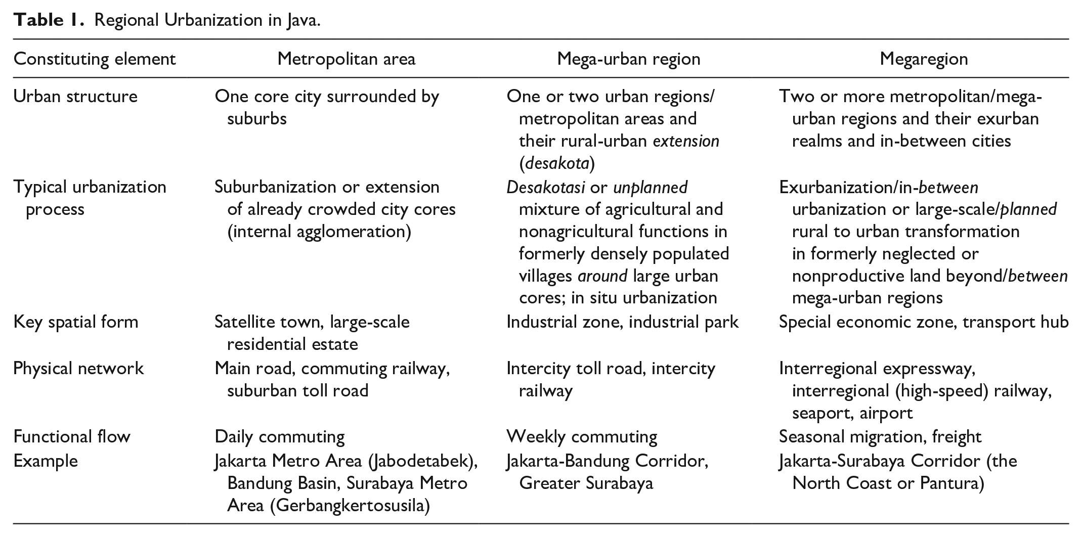
As summarized in Table 1, Java’s most dynamic spatial forms and highly interconnected nodes are located not just within but also beyond the physical and functional borders of metropolitan areas and mega-urban regions, forming an island-scale megaregional space. While (post)suburbanization and desakotasi feature in Southeast Asia’s metropolitanization and mega-urbanization (Hudalah and Firman 2012; McGee 1991), Java’s megaregionalization is characterized by planned conversion of the land outside or between established boundaries of mega-urban regions into large-scale infrastructure and SEZs. The latter is closely related to exurbanization and in-between urbanization found elsewhere (Lang and Knox 2009; Nelson and Dueker 1990; Phelps 2017; Sieverts 2003; Young and Keil 2010). While basic services, land use conversion, and interlocal government coordination appear to be the main policy issues in Indonesia’s metropolitan and mega-urban planning (Hudalah, Firman, and Woltjer 2014; Hudalah et al. 2013), it is connectivity and competitiveness which appear to be highlighted in megaregional planning (Hall and Pain 2006; Innes, Booher, and Di Vittorio 2010; Ross 2009).
Regional Urbanization in Java.
The megaregion of Java’s North Coast is the country’s most urbanized region where major new projects in the forms of SEZs, new towns, premium infrastructure hubs, and other exceptional spaces aiming at improving the nation’s economic performance and competitiveness build up. It is likely that these major projects will no longer depend on the agglomeration advantages of metropolitan areas and mega-urban regions. As also evident in the cases of Paris and Atlanta, a megaregion can rise due to the increased freight between the constitutive metropolitan areas and mega-urban regions (Dablanc and Ross 2012; Heitz and Dablanc 2015). In the case of Java, the increasing logistical flows might partially be related to the operation of large-infrastructure networks such as the Great Mail Road, Trans Java Expressway, and soon the high-speed rail line.
While the oligarchic private sector leads metropolitan area-wide urban development (Hudalah 2017; Winarso and Firman 2002), the national government, through ad hoc development planning policies and commissions (such as PSN and MP3EI) and state-owned enterprises (and their global and private partners), plays an important role in facilitating regional urbanization in Java at the megaregional scale. This, to some extent, confirms the effectiveness of developmental state rescaling found elsewhere, such as in China’s megaregions (Su et al. 2017). However, in contrast with China’s integrated and multiscale policy and governance approach (Tan 2017; Yang, Song, and Lin 2014), regional policy regimes in Indonesia tend to be sector-oriented and, sometimes, overlap with each other—reflecting long-recognized interministerial competition, rivalry, miscoordination, and fragmentation (Davidson 2015; Hudalah and Woltjer 2007; Resosudarmo, Ardiansyah, and Napitupulu 2013; Smoke and Lewis 1996). For instance, the Jakarta-Bandung High-Speed Rail Line project has been controversial because it, among other things, seems quite uncoordinated with the larger goal of improving the connection between Jakarta and Surabaya as it diverts such a line far south of that previously indicated in the Master Plan for the National Railway System (RIPNas). The provincially initiated airport of Kertajati was also too late in catching the president’s attention as it was considered too far from the existing metropolitan agglomerations of Jakarta and Bandung and, thus, poorly placed to draw substantial traffic away from the existing congested international airports.
Our study suggests that it is sector-led nonstatutory planning such as MP3EI and PSN that influences the direction of spatial plans, and not the other way around. The making of these nonstatutory plans is not a bottom-up community or locally based affair as found elsewhere (Jewell, Roberts, and McInnes 2000; Muktiali 2009; Potts 1999) but is driven either by the market (in the case of the Trans Java Expressway and the high-speed rail line) or by the subnational politics (in the case of Kertajati Airport) and facilitated by the nation state. They were typically prepared or coordinated by ad hoc commissions appointed directly by the president. While explicit policies through integrated spatial plan and multilevel governance strategies largely characterize China’s megaregion cases (Su et al. 2017; Ye 2013), Indonesia’s centralized sectoral and ad hoc policies play rather an implicit (indirect, partial) role in promoting the emergence of megaregion. The policies were not designed comprehensively to develop a megaregion from the very beginning, but their intentions have played an important part in driving megaregionization through improvements in intermetropolitan and inter-mega-urban connectivity and interregional competitiveness.
The absence of integrated megaregion-scale spatial planning contributes to the dynamics and complexity of megaregionalization in Java. Actually, under the decentralized system, the central government still has the authority to manage interprovincial affairs, including those that bear upon metropolitan areas, mega-urban regions, and megaregion formation. However, problems occur in practice due to the unclear distribution of authority not just between sectoral government institutions but also between tiers of government and between governmental agencies and the private sector. Central and regional governmental institutions have limited authority to intervene in local spatial planning. Meanwhile, due to their limited resources and capacity, local governments tend to have egoistic or inward-looking behavior that negates cooperation (Firman 2014). Furthermore, the privatization of industrial space hinders collective action, resulting in social, economic, and spatial fragmentation (Hudalah et al. 2019).
As can be found in the Philippines (Ortega, Acielo, and Hermida 2015), the implementation of the government’s implicit policies is also conditioned by global economic factors. Geopolitical processes, within both the national and international context, have co-constituted large-scale economic processes, agglomeration, and global competitiveness in the licensing of this new scale of urbanization (Jonas and Moisio 2018). In Indonesia, processes of “glocalization” (Swyngedouw 2004) are reflected in the role that physically in-between cities are considered to play in helping mediate local responses to pressures of global competition. From a megaregional perspective, the interjurisdictional scope of large-scale infrastructure and urban projects is seen to mediate pressures of global competition by achieving economies of scale and helping adsorb the impact of economic volatility (Ross 2009).
Conclusion
Drawing on the example of Java’s North Coast in Indonesia, this paper has sought to connect academic interest in the extent and nature of large-scale urbanization more strongly to questions of policy and institutions. While urbanization at this scale has rarely commanded popular political or national, regional, and urban planning appeal, it nevertheless seemingly has always had important explicit or implicit “bottom line” economic or competitiveness connections to treasuries or finance ministries. Greater consideration of the planning behind megaregion formation can usefully be made alongside the morphological and functional perspectives found in the extant literature. Consideration of the intentions or plans of governments—even if they are implicit and even if there are problems of implementation—are likely helpful in understanding large-scale urbanization processes across East Asia. The Indonesia case happens to be one that highlights the discrepancies between intentions of the state and inadequacies in policy implementation and their effects on the formation and functioning of megaregions.
It will be especially important for a strong measure of interdisciplinarity in future research examining the emergence and effects of urban megaregion across the world. It will be important to bring together urban planning and urban and political geographical analysis of the intentionality, the planning, and the institutionalization of megaregions with the economic geographical analysis of the morphological and functional expression of megaregions. As we have sought to demonstrate here, it will also be important for any tendencies in each of these bodies of literature and their associated theories to be attuned to important continental and subcontinental variations on these common themes—including the exchange of policy as these pertain specifically to megaregion formation.
Finally, several planning policy recommendations can be put forward. First, and almost universally, there is an undoubted need to combine the spatial (physical-environmental) planning systems and the sectoral (socioeconomic) planning system to build more integrated planning policy and institutional arrangements at the megaregional scale. Yet the challenges are enormous since the fashioning of institutional arrangements and spatial and sectoral planning at this scale has rarely carried much appeal within national or local government circle. Optimism prevails regarding the prospects for collaboration among local governments in the form of “metropolitics” (Orfield 1999) that may extend to the megaregional scale. Yet our evidence suggests that interlocal government collaboration per se would not suffice. In the case of Indonesia, the central government led by coordinating ministries of maritime (welfare) or economic affairs needs to play an anticipative and coordinative role in intermediating local aspirations and global competitive pressures by cultivating the benefits of megaregion development as the national economic engine while at the same time attempting to mitigate the regional impacts. To improve interministerial coordination and policy integration, leading ministries such as the Ministry of Industry should adequately incorporate regional approaches and spatial analysis in the design of their sectoral planning policy. Similarly, the Ministry of Land and Spatial Planning needs to take state power and global economic and technological forces into account more seriously if they want their regional spatial plans to be more implementable. Not least here are questions over the foresight needed to ensure that the opportunities offered by significant land value capture are identified and extracted through appropriate mechanisms. However, the environmental consequences such as ecological connectivity and food and energy security are hardly less important for an island-based megaregion such as the Java’s North Coast. In this regard, the planning challenges of the apparently distinctive desakota morphology found in East Asia’s megaregional urbanization (McGee 1991) have their partial parallels elsewhere in the Zwischenstadt or in-between urbanization in Europe (Sieverts 2003) and speak to the need to take more seriously interurban or interplace (Phelps 2017) patterns of urban economic organization into account. The main issues here are the cohesiveness and legibility of the stretches of megaregion territory to people, politicians, and planners. In the case of Java, other policy strategies might be developed to address the issues of regional disparity and cohesion that have typically attended the formation and promotion of megaregions (Scott 2019) and which ultimately undermined intentionality elsewhere (Hanes 1993) by way of improving the performance of small and mid-sized cities and empowering the underdeveloped regions of the South Coast.
Footnotes
Acknowledgements
The authors would also like to thank the editors and referees for their constructive comments on previous drafts of this paper.
Declaration of Conflicting Interests
The author(s) declared no potential conflicts of interest with respect to the research, authorship, and/or publication of this article.
Funding
The author(s) disclosed receipt of the following financial support for the research, authorship, and/or publication of this article: This research is partially funded by the Ministry of Research, Technology and Higher Education under the World Class University (WCU) Program managed by Institut Teknologi Bandung.