
Abstract
Historic resources are important community assets that may be at risk from natural hazards, but few studies examine their risk or protection. We map the location of historic resources in municipal areas in Colorado (n = 863) and find that 16.8 percent of National Register and State Register properties (n = 145) intersect with a mapped floodplain, as well as 74.0 percent of National Register districts. We then study fourteen case study municipalities that are representative of those with substantial shares of their historic resources in floodplains. We find that most municipalities value their historic resources but very few proactively plan for their protection from hazards.
Introduction
Over the past several decades, historic preservationists and planners have found common cause in goals of place-making, economic development, and environmental sustainability (Minner 2016; Ryberg-Webster 2019; Wojno 1991). Historic resources, including buildings, objects, monuments, districts, and sites, bring numerous benefits to communities. They contribute to economic development through building preservation, heritage tourism, and business activity on main streets and along commercial corridors (Rypkema and Cheong 2013; Bradbury 2011; Listokin, Listokin, and Lahr 1998). Historic preservation policy has been used as a tool for urban revitalization, particularly in aging central-city neighborhoods (Coulson and Leichenko 2004; Ryberg-Webster and Kinahan 2014) and to provide affordable housing (Rypkema 2002). Historic resources also provide intangible benefits by adding to a community’s sense of place, place attachment, and educating members of a society about their collective histories (Barthel 1996).
Historic resources are often located in areas exposed to natural hazards (e.g., floods and earthquakes), which pose two threats. Natural hazards can cause direct damage to the resource itself or indirect damage due to inadequate repair or recovery. Anthropogenic climate change is making many natural hazards more frequent and severe and putting historic resources at greater risk (Fatorić and Seekamp 2017a; Horowitz 2016; Park 2018).
Historic resources are non-renewable resources—once they lose their integrity or are destroyed, they cannot be replaced. Protecting historic resources from natural hazards is therefore a shared goal of historic preservationists and planners. Yet, there is limited research on the number of historic resources that are potentially at risk from natural hazards or how the tools of planning are used to mitigate such threats. While numerous studies describe the threats posed to individual historic resources (e.g., Bresler 2017; Rutz, Riley, and Foster 2014) or describe specific conservation techniques for historic structures (e.g., Porter and Artim 2010), few have analyzed the risk to communities’ historic resources collectively, for example, at a planning scale. 1 This is an important gap in our knowledge because planning and policy decisions about historic preservation and natural hazard mitigation are typically made at the local government level (Fatorić and Seekamp 2018; Holtz et al. 2014; Reeder-Myers 2015).
This paper presents the findings of a mixed-methods, comparative study of historic resources and flood risk in Colorado, a large and geographically diverse state in the western United States. First, we use geographic information system (GIS) analysis to define the scope of the issue—the number of historic resources that are potentially at risk from flooding by virtue of their location. Second, we examine the plans, regulations, staffing, and non-governmental resources of a group of municipalities with substantial risk to flood hazards, to understand whether local governments are proactively planning for flood hazards and what their capacity might be to manage a disaster that affects historic resources. We conclude by discussing the implications of our findings for practitioners, the limitations of our study, and potential avenues for further research.
Historic Resources: Their Value and Risk from Natural Hazards
Historic resources provide tangible and intangible benefits to communities. Historic preservation, downtown revitalization, and heritage tourism are important tools for economic development (Carr and Servon 2009; Listokin, Listokin, and Lahr 1998; Phillips and Stein 2013), especially for economies shifting away from agriculture and extractive industries (Mason 2005) and in post-industrial cities (e.g., Kapp and Armstrong 2012). In Colorado, for instance, historic preservation projects and investments produced nearly $4 billion in direct and indirect economic benefits from 1985 to 2015, with much of the benefit accruing to small towns and resort communities (Colorado Preservation 2011). These economic impacts translate to 27,335 jobs in the state, $1.2 billion in additional household earnings, $92 million in state sales tax revenue, and $33.4 million in property tax revenue (Colorado Preservation 2017). Preserving historic buildings and infrastructure also has numerous environmental benefits, such as energy savings and reducing the carbon footprint of development (Avrami 2016; Jackson 2005). Intangibly, historic resources contribute to place attachment, or the “bonding that occurs between individuals and their meaningful environments” (Scannell and Gifford 2010, 1) and improve the quality of life for residents (Stipe 2003; Tweed and Sutherland 2007). Historic preservation has also been shown to contribute to disaster preparedness, post-disaster recovery, and community resilience (Berkes and Ross 2013; Appler and Rumbach 2016; Henderson and Seekamp 2018; Huang 2018; Rumbach and Appler 2019; Scannell et al. 2016).
Existing research suggests that historic resources are often at risk from natural hazards. In the natural hazards planning and disaster studies literatures, risk refers to the likelihood that an asset (in this case, a historic resource) will suffer the damaging effects of a hazard. Risk is shaped by two variables—exposure and vulnerability. Exposure measures whether an asset is physically located where a hazard event will occur. The historical development patterns of the United States mean that many historic structures and archeological sites are located near environmental assets, for example, waterways, coastlines, and mountains, exposing them to natural hazards (City of Annapolis 2018). The expansion of human settlements into the wildland–urban interface—natural terrain and areas subject to burning—has diminished physical buffers and exposed historic resources to fire. Historic resources also tend to be vulnerable, or are likely to suffer the damaging effects of a hazard event, because of their age, specialized materials, or building techniques, among other factors. Historic buildings cannot be treated with certain fire retardants ahead of a wildfire, for example, making them more likely to suffer damage relative to the overall building stock. Studies have shown that historic buildings recover at a slower rate post-disaster than non-historic buildings due to the cost of materials, labor, and post-disaster regulations (Al-Nammari and Lindell 2009; Spennemann 1998). Historic resources can also suffer further damage after a disaster due to neglect or improper recovery (e.g., Eck 2000). After Hurricane Katrina, for instance, many historic buildings were left exposed to weather damage because the protective blue plastic tarps provided by the federal government would not adhere to slate or tile, a common roofing material on older homes and buildings (Allen 2007).
The risks posed to historic resources by natural hazards will likely be made worse due to climate change. The effects of climate change, such as warming temperatures, rising sea levels, and increased frequency of droughts, fires, and storms, among others, will heighten threats to resources in hazardous areas and expose greater numbers of resources to threats (Englander 2015; Ferguson-Bohnee 2015; Pavlova et al. 2017). Several large-scale studies of climate change and historic resources, particularly from coastal states, have underscored this point. Anderson et al. (2017) model the impacts of sea-level rise on archeological sites across a nine-state region in the southeastern United States and find that a one-meter increase would destroy or submerge over 13,000 recorded sites, including 1,000 that are eligible for the National Register (NR) of Historic Places. Similarly, Marzeion and Levermann (2014) estimate that sea-level rise could affect 19 percent of World Heritage Sites, and Gonzalez et al. (2018) find that climate change in the United States will disproportionately affect national parks.
Study Context
Our research on historic resources and natural hazard risk is based in Colorado, located in the mountain west region of the United States. Colorado is an ideal site for our study because of its long history and large number of historic resources; diversity of settlement types; dynamic hazards environment; and the economic transition of many of its communities from agriculture and extractive industries toward heritage tourism and outdoor recreation (e.g., Mitchell and Gallaway 2019; Smith 2019)—a trend we also see in other states (Ramaswamy and Kuentzel 1998). Colorado is also representative of many western and non-coastal states, which are largely absent from the literature on natural hazards and historic preservation.
Colorado experiences a diverse array of natural hazards, from floods, wildfire, and drought to geologic hazards like landslides and avalanches. Climate change will exacerbate the risks these hazards pose by making them more frequent, severe, or irregular (Lukas et al. 2014). Floods are among the most common hazards in Colorado, in their frequency and impact on human settlements. From 1955 to 2017, Colorado suffered twelve presidentially declared (federal) disasters that involved flooding as well as hundreds of state and local events. The two costliest disasters in Colorado’s history, the Big Thompson Flood of 1976 and the 2013 Floods, were both precipitation-driven extreme flooding events (Gochis et al. 2015; Grundfest, White, and Downing 1978).
Historic Resources and Flood Exposure: Statewide Methodology and Findings
In the first stage of our study, we ask, what is the potential exposure of historic resources in municipalities in Colorado to flood hazards? 2 We selected municipalities as our scale of analysis for two reasons. First, municipalities are where historic resources tend to be clustered, with collective impacts on a community’s sense of place and on local economic development. Second, the municipal scale is where land use, historic preservation, and hazard mitigation plans are typically adopted and given the force of law. We define historic resources as those listed on the NR of Historic Places and the Colorado State Register (SR) of Historic Properties. We did not include locally designated historic resources in this study because due to a lack of available data for most municipalities in the state, an important limitation we discuss in the conclusion of the paper. 3
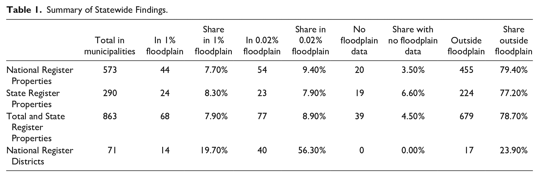
The Colorado State Historic Preservation Office (SHPO) provided us with a geolocated database of historic resources. We cleaned the database to remove duplicates and correct other minor issues. We then downloaded the NR of Historic Places public dataset, which includes boundary information for NR districts, and a municipal boundary shapefile from the Colorado State Demography Office. We did not include SR districts in our analysis because the Colorado SHPO does not maintain data on their geographical boundaries. We brought these data into ArcGIS software, selected historic resources within municipal boundaries and assigned each a unique identifier. Statewide, we found that there are 573 resources on the NR of Historic Places located in municipal areas, and 290 additional resources on the SR of Historic Properties. There are also seventy-one NR districts within municipal areas (Figure 1).
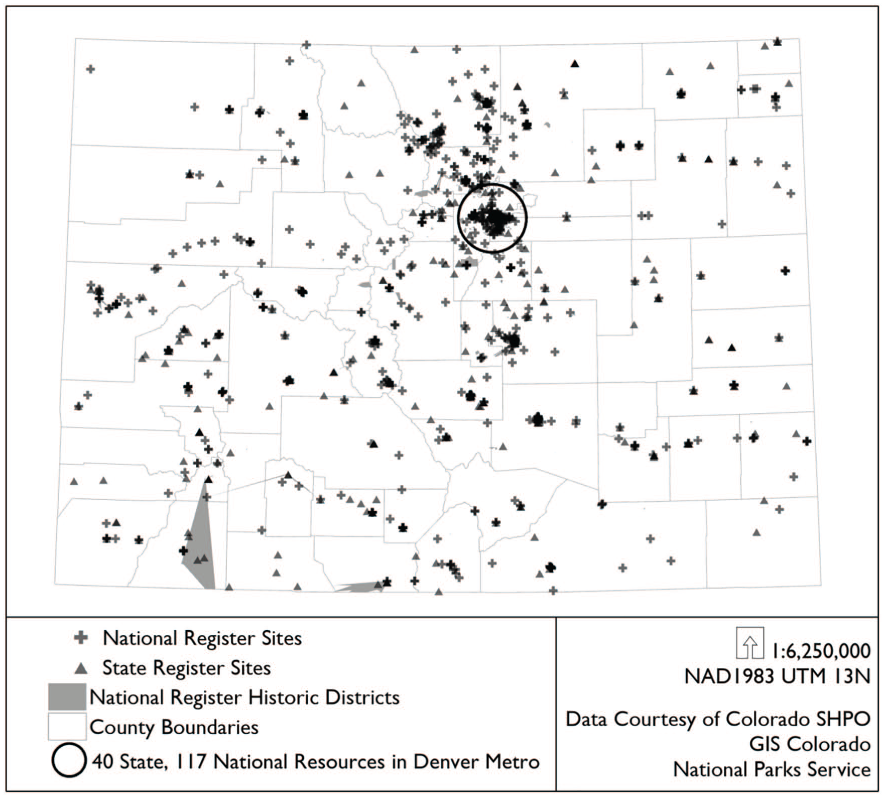
Location of historic resources in municipal areas in Colorado.
We then assembled floodplain data for each municipality in Colorado. First, we downloaded the National Flood Hazard Layer (NFHL), a national geospatial database of digital floodplain data maintained by the Federal Emergency Management Agency (FEMA). The NFHL only includes floodplain maps created after 2003, however, which fully covers just twenty of the sixty-four counties (31%) in Colorado. We supplemented the NFHL with digitized floodplain maps provided by the Colorado Water Conservation Board’s Colorado Hazard Mapping Program for an additional fourteen full counties (22%) and three partial counties (5%). This means that twenty-three counties (36%) did not have any digital floodplain data available. For municipalities in those counties, we downloaded scanned copies of the “paper” flood insurance rate maps (FIRMs) from FEMA’s Flood Map Service Center and brought them into ArcGIS for analysis.
Together, these maps are the best current data on flood hazard areas for Colorado municipalities. Some communities and counties, typically in very rural parts of the state, do not have access to any floodplain data. Ninety-five percent of historic resources in our study, however, are located in municipalities with some form of floodplain maps.
Our next step was to do an overlay analysis to identify how many historic resources are geographically located in the 100-year (1% annual chance) and 500-year (0.02% annual chance) floodplains (Figure 2). We found that 145 (or 16.8%) of the NR and SR properties in our study are located partly or fully within these mapped floodplains. We also found that fourteen of the NR districts (19.7%) are at least partly in a 100-year floodplain and an additional forty (56.3%) are at least partly in a 500-year floodplain (Table 1).
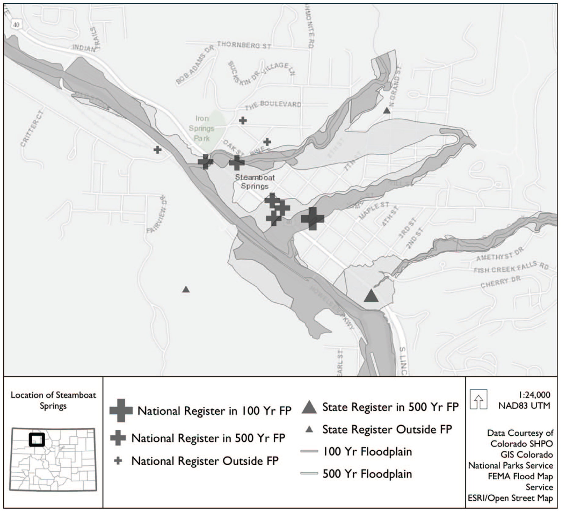
Example of municipal analysis of historic resources in floodplains (FP) for Steamboat Springs, Colorado.
Summary of Statewide Findings.
Characterizing Resources at Risk
Historic resources is a broad category that includes numerous kinds of assets (buildings, objects, monuments, and sites). What resources are at risk to floods? We collected information from each resource’s NR or SR nomination form and used Internet searches to determine the resource’s (1) period of significance, (2) area(s) of significance, (3) ownership, and (4) current use. A historic resource’s period of significance is the time when the property attained the significance qualifying it for NR or SR listing, and may range from a single year to decades. The large majority of historic resources in Colorado are from the era of European American settlement in the state, beginning with the gold rush in the mid-1850s and continuing into the early and mid-20th century. The historic resources in floodplains reflect this, with a large majority of resources dating from 1880 to 1940. A historic resource’s area(s) of significance describe the property’s “contributions to the broader patterns of American [or Coloradan] history, architecture, archeology, engineering and culture” (History Colorado 2019). There are thirty categories of significance that can describe a historic resource, from agriculture and architecture to ethnic heritage and maritime history, and historic resources may have multiple areas of significance associated with them. We found that resources in floodplains have diverse areas of significance, the most common being architecture (36%), transportation (7.5%), engineering (7.1%), commerce (6.4%), and social history (4.5%).
The ownership of historic resources on the NR and SR has significant implications for their protection from flooding, as ownership implies the party primarily responsible for the protection and restoration of a resource. The historic resources in floodplains have a relatively even-split of ownership arrangements; seventy-seven (51.7%) are privately owned, sixty-three (42.3%) are publicly owned, and three (2.0%) are owned by non-profit organizations.
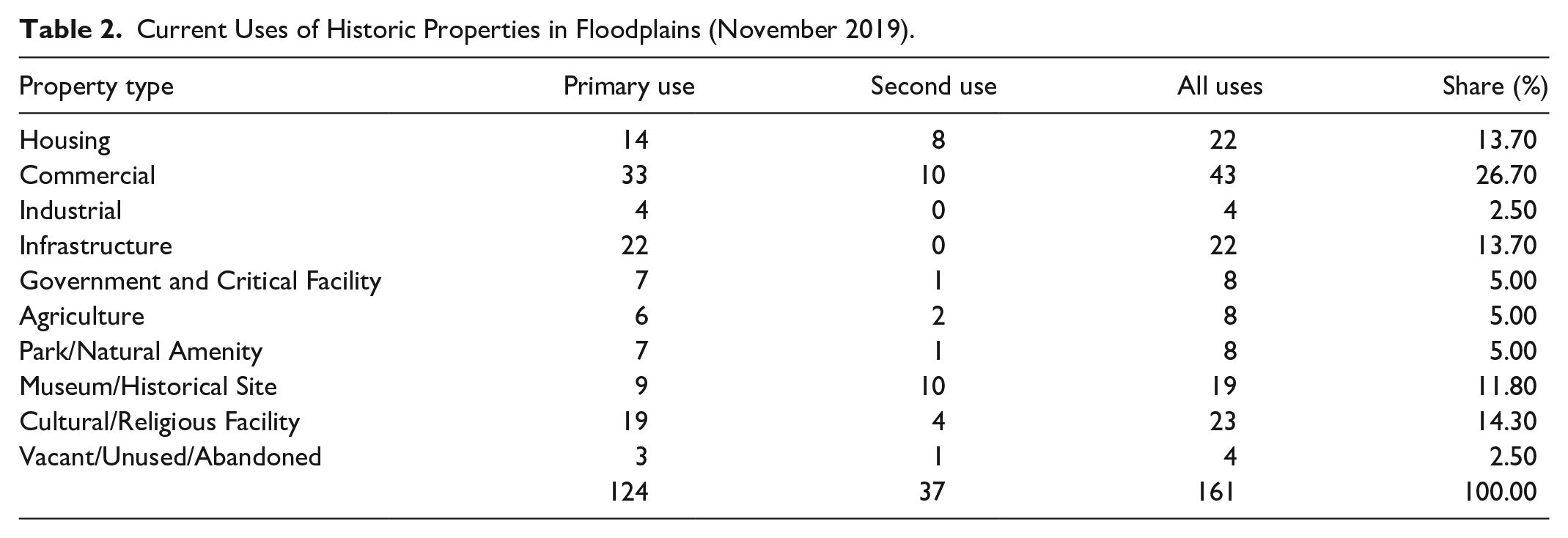
Last, how are historic resources at risk from flooding currently used (Table 2)? We found that 141 (or 97.5%) of the historic resources in floodplains are currently in use, most commonly for commercial activities including hotels, retail stores, and restaurants (26.7%); as cultural and religious facilities (14.3%); infrastructure (13.7%); and housing (13.7%).
Current Uses of Historic Properties in Floodplains (November 2019).
State-Level Plans and Resources
Next, we wanted to know how state and local governments are planning for the protection of historic resources from natural hazards. Because local government planning may be guided, in part, by state-level plans and policies, we examined several of Colorado’s key state-level plans and their treatment of historic resources and natural hazard risk. Overall, we found that these plans provide a supportive environment for the protection of historic resources, but few dedicated resources to help municipalities to achieve that goal.
State-level hazard mitigation plans work to identify long-term policies and actions that can reduce disaster risk and losses. The Colorado Natural Hazards Mitigation Plan 2018–2023 includes a goal to “support mitigation initiatives and policies that promote . . . cultural resources and historic preservation” (DHSEM 2018, 2). While the plan itself does not contain an assessment of risks to historic and cultural resources, it includes a new mitigation action to develop a “geospatial historic properties database, to be integrated with the planned state asset and critical facility and infrastructure geospatial database” to “identify those [historic properties] that might be at risk to hazards.” The Colorado Resiliency Framework (State of Colorado 2015), which lays out the state’s strategy for long-term community and economic resilience to natural hazards, climate change, and other shocks and stresses, also includes a strategy to “develop guidance for pre-disaster mitigation for the protection and preservation of cultural resources and facilities.” The State Emergency Operations Plan (EOP) (Colorado Division of Homeland Security & Emergency Management 2019, 5) provides “general guidelines on how the state carries out its . . . responsibilities to address an emergency or disaster event.” The EOP centers on the state’s response and recovery (rather than mitigation) responsibilities and describes how cultural and historic resources should be identified and treated during a disaster. When the state’s emergency operations center is “activated” during an emergency or disaster, personnel are required to ask whether historic resources are threatened or damaged, what resources are threatened or damaged, and what protective measures are recommended by experts. The linking of historic resources to emergency response, an institutional evolution spurred by the 2013 floods, is an important step toward protecting historic resources after disasters. The state historic preservation plan, The Power of Heritage and Place, does not directly engage with natural hazards and disasters. Although the plan broadly situates preservation in the context of sustainability and climate change, it does not explicitly address the threats posed to historic resources. History Colorado (2019), the state’s historic preservation office, has a small but dedicated grant program that provides assistance to a designated historic resource that is in imminent danger of being “lost, demolished, or seriously damaged” after a sudden and unexpected natural hazard event.
Planning and Adaptive Capacity at the Municipal Level
Research Design and Data Collection
Our statewide analysis found that 157 municipalities in Colorado (of 271, or 58%) had at least one resource listed on the NR or SR of Historic Places or had a NR Historic District. Of these, twenty-nine municipalities had a substantial proportion (more than 40%) of their historic resources in a mapped floodplain. These communities were diverse—in their size, geographic location, and local economic bases. How are these different communities planning for flood risk for historic resources, and what is their capacity to manage disasters that affect historic resources? We selected fourteen municipalities that are broadly representative of those with substantial historic resources in floodplains, using five criteria: the number and share of historic resources at risk, the age of the community’s floodplain data, geographic region, and population. We use a multiple-case study design where municipalities are the context and its historic properties, considered collectively, are the units of analysis (Yin 2009, 45–46). 4
First, we analyzed each community’s key plans and regulations related to historic preservation and flood hazards. In the United States, local government laws and planning typically offer the strongest protections for historic resources (Miller 2008). Although the National Historic Preservation Act provides the framework for the NR and SR and the SHPO system, it does not mandate preservation; private owners of historic resources must willingly participate for a property to be listed, and listed properties are not federally protected from demolition (Sprinkle 2014). Municipal governments, however, can protect historic resources through plans and regulations (Minner 2016). In Colorado, for instance, local governments are given broad authority to “plan for and regulate the use of land within their respective jurisdictions,” including the preservation of areas of “historical and archaeological importance” (C.R.S. 29-20-104).
We collected and analyzed four types of municipal plans or regulations for the case study communities:
Comprehensive plans are long-range plans that address the geographic area of a local government and that guide decisions about development. Comprehensive plans are also a tool for local governments to achieve sustainability goals across multiple sectors of development, including hazards planning and historic preservation (Godschalk and Anderson 2012; Godschalk and Rouse 2015).
Local governments may also write hazard mitigation plans, which are intended to help communities take a “proactive, comprehensive approach” to “reduce escalating disaster costs and speed the expenditure of federal mitigation funds” (Lyles, Berke, and Smith 2014, 90). While local hazard mitigation plans have to meet certain state and federal criteria, local governments can determine their own mitigation priorities and approaches, including protection of historic resources.
Historic preservation ordinances are local statutes that are “enacted to protect buildings and neighborhoods from destruction or insensitive rehabilitation” (Potter 2013). Preservation ordinances provide “the finest grain of preservation regulation” in the United States (Minner 2016, 73) and typically offer stronger protections than the procedural requirements associated with federal laws (Miller 2003, 7).
Floodplain management ordinances are required for communities that participate in the National Flood Insurance Program and describe what development activities are permitted, regulated, or restricted in mapped floodplains.
We were also interested in the municipalities’ adaptive capacity, described by Wall and Marzall (2006, 377–78) as a set of characteristics that allows a community to perceive a threatening circumstance, determine a pathway forward, and develop tools and processes necessary to manage risk. Communities with high adaptive capacity can cope, manage, or adjust to shocks and stresses, including natural hazards or the effects of global climate change (Smit and Wandel 2006). In the context of this study, a community with high adaptive capacity can foresee the potential impact of natural hazards on historic resources and is able to develop a plan or strategy to reduce that risk. After a disaster, the community can support the recovery or adaptation of its historic resources and is able to recognize new or different threats that might arise. While different studies measure adaptive capacity differently, some common variables include a community’s access to information on hazards and the systems potentially at risk (i.e., situational awareness), strong and transparent decision-making institutions, formal and informal networks for action, and the human knowledge and expertise necessary to support adaptation strategies (Brooks and Adger 2005). For our analysis, we judged whether a community has high, medium, or low adaptive capacity based on several indicators:
Does the community participate in the Certified Local Government (CLG) and/or Main Street programs? The CLG is an important source of local government funding and technical assistance for historic preservation nationwide. To become a CLG in Colorado, communities must enact and enforce a historic preservation ordinance, create a historic preservation commission, attend trainings or educational events, maintain a system for surveying and inventorying historic properties, provide opportunities for public participation in preservation, and review NR nominations in their jurisdiction (History Colorado 2019). In return, CLG communities are given access to historic preservation training, technical support, CLG grant programs, and state historic preservation tax credits. The Main Street Program is a network of small and medium-sized communities who promote the revitalization of historic downtown areas. Main Street communities in Colorado are eligible for specialized training, project and consulting grants, access to a historic architect, and communications assistance. We view a local government’s participation in the Main Street and CLG programs as evidence of their internal capacity to identify and reduce risk to historic properties or recover after a disaster event, and their ability to draw upon external networks and resources to help accomplish those goals (e.g., Rumbach and Appler 2019).
Does the local government have a trained historic preservationist on-staff? Preservation professionals can provide expert guidance during emergency management and disaster planning processes, maintain and provide data critical to recognizing and managing risk, and advocate for historic preservation needs during crises. They are also more likely to maintain external relationships with other preservationists through professional organizations or knowledge-sharing events like conferences and seminars.
Does the community have a historic preservation institution such as a historical society or museum? These institutions are repositories of local knowledge and institutional memory about historic resources, provide a point-of-contact during an emergency event, and can be advocates for historic preservation during complex recoveries.
Finally, we conducted semi-structured interviews with a key informant from local government or the preservation community in each municipality, to help contextualize the above data. Our interview guide included primary and follow-up questions about historic resources and their value to the community; the community’s experience and outlook on flood hazards; and the local capacity to mitigate or manage flood risk. We recorded and transcribed the interviews and coded them using the two-cycle approach as described by Saldaña (2015), first organizing the data by themes represented in our interview guide and then creating sub-codes and identifying emergent categories and themes for analysis.
Municipal-Level Findings
The results of our municipal-level data analysis highlight important similarities and differences among communities with significant numbers of historic resources in floodplains. In general, we found that municipalities, regardless of their size or location, recognize the value of historic resources. Boulder’s comprehensive plan, for example, describes a need to protect historic resources for their “cultural and heritage tourism values” while Manitou Springs acknowledges its historic downtown as the “main engine” of the local economy. In small towns and tourism destinations, historic resources are often described as a source of identity and pride. One interviewee from Steamboat Springs, for example, explained, “The general culture up here [is that] people are very proud of our heritage and the small town, authentic feel of this place . . .” Four communities (29%) only briefly acknowledge their historic resources in their plans, however. These communities were also more likely to describe heritage tourism as less important to their economies. This suggests that the economic value of certain historic resources is a primary motivator of local government support for preservation.
We also found that few communities proactively plan to mitigate risk to historic resources. The communities we studied varied widely in their planning for historic preservation, from those with stand-alone historic preservation plans (Boulder) or comprehensive plans that engage with historic preservation (Florence, Manitou Springs, Montrose, Ouray, Steamboat Springs) to those that only briefly mention historic resources. None of these comprehensive or master plans (except one, see below) engage directly with the issue of historic resources and disaster risk. Similarly, eight (57%) of the communities’ hazard mitigation plans described historic resources as an asset, and seven (50%) make some specific mention to their unique vulnerability to natural hazards, but none moved beyond generalities or included historic resources in their risk assessment or mitigation priorities. Only one community, Manitou Springs, explicitly and proactively planned for historic resource risk to flooding. The city’s combined hazard mitigation/comprehensive plan update (City of Manitou Springs 2017) recognizes that the city’s “historic and cultural resources are a key component of its tourism economy and quality of life” and assesses the vulnerabilities of the building stock to natural hazards and damage that could be caused to historic buildings. The plan then describes several specific goals and actions to protect historic resources, with specific actions and a timeline for implementation. Manitou Springs experienced a series of damaging disasters in 2012, 2013, and 2015 that threatened their historic downtown and main commercial district, a powerful motivator for the community to center its planning efforts on natural hazards and historic preservation.
Eleven case study municipalities (79%) have a historic preservation ordinance in-place, and all fourteen (100%) have floodplain development regulations, which is a positive sign for flood resilience as these regulations can be useful tools for protecting historic resources. We found that twelve of the communities’ regulations (86%) acknowledge the unique vulnerabilities of historic resources by exempting property owners from certain redevelopment requirements post disaster. This is important because property owners without exemptions would be required to repair a building or property to contemporary development standards after major damage (e.g., elevated to above base flood elevation), which could severely affect the historical integrity of the resource. 5 Only two communities (14%), both small and with relatively older development codes, do not explicitly acknowledge the ability of a historic property owner to receive an exemption from redevelopment requirements. One other important limitation we saw, with communities who rely on floodplain regulations rather than historic preservation ordinances to exempt property owners (Holly, Ouray, and Sterling), is that such regulations only apply to the regulatory (i.e., 100-year) floodplain and not the advisory (500-year) floodplain.
We also found that historic preservation ordinances offer varying levels of protection to historic resources based on the decision-making authority given to the property’s owner. Several municipalities have ordinances that lean heavily in favor of protection of historic resources even without owner cooperation. Boulder, for example, prohibits the demolition of any structure older than fifty years without a city-level review. Others offer weaker protections by making participation in the preservation program entirely and giving the owner the power to withdraw a property’s historic status at any time, allowing it to be altered, redeveloped, or demolished (Craig, Dolores, Lamar, Walsenburg). Half of the communities’ preservation ordinances offer “middle-of-the road” protections, empowering non-property owners to nominate properties for landmark status or requiring local government review of permits to substantially alter or demolish a protected property. This means that in some communities, historic resources damaged by floods may have regulatory protection from hasty reconstruction or demolition, while others depend on the property owner to protect against such risks.
Last, we found that communities varied significantly in their adaptive capacity, and variation was strongly associated with community size and geographic location. Overall, two-thirds of the communities participated in the CLG and/or Main Street programs, but very small communities and some communities in rural regions did not (Table 3). All of the case study communities have a historical society or local museum, which we view as a positive indicator of adaptive capacity. These organizations vary widely in their size and resources, however. For example, Historic Boulder has full-time staff and an operational budget that allows it to contribute actively to pre-disaster planning and post-disaster recovery. The historic preservation organizations in smaller communities have only volunteer or part-time staff, which limits their ability to robustly engage in pre-disaster planning and post-disaster recovery plans and policy-making efforts. Last, just four communities (28%) have a trained historic preservationist on-staff. These included the largest cities in our study (Boulder and Pueblo) and two smaller ones (Manitou Springs and Florence).
Summary of Local Government Plans and Capacities.
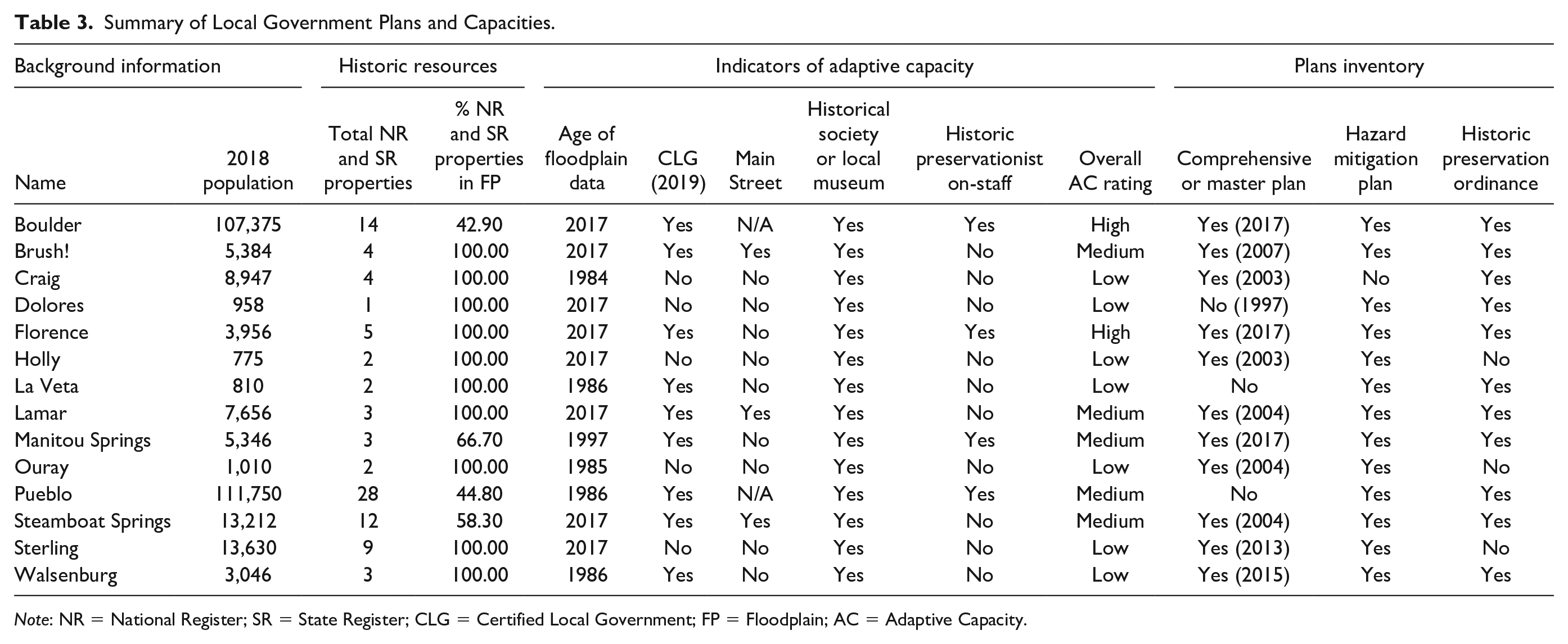
Note: NR = National Register; SR = State Register; CLG = Certified Local Government; FP = Floodplain; AC = Adaptive Capacity.
Discussion, Study Limitations, and Directions for Future Research
What lessons can practicing planners and historic preservationists take from these findings? In this final section of the paper, we discuss the practical implications of our study’s findings, its limitations, and directions for future research.
It is clear from our study that a substantial number of historic resources are at risk from natural hazards, yet few communities are proactively planning for it. Historic resources are valuable assets with a wide variety of contemporary uses, but preservationists and natural hazards planners largely work independently from one another. This dynamic will need to evolve if we are to best protect these vulnerable assets from ever-more-frequent storms, fires, and climate-induced extreme events. Communication and collaboration across departments and organizations seem key; in Manitou Springs, for instance, emergency managers, planners, and preservationists worked together on a combined hazard mitigation and comprehensive plan update, which resulted in innovative policy recommendations and planning strategies for protecting historic resources.
Planners and preservationists should also note that many of the resources necessary for planning for disaster risk are already in place. Practitioners and decision makers in many communities have access to natural hazard data, information about the location of historic resources, and planning and policy tools like comprehensive plans, historic preservation ordinances, and hazard mitigation plans. Many states, including Colorado, have financial resources available for communities to update their comprehensive plans and hazard mitigation plans. These existing tools and resources can help practitioners to determine the threats that natural hazards pose to historic resources, and develop and implement risk-reduction strategies, all without the need to create additional plans or vehicles for regulation.
Our study also shows that many smaller communities have historic resources at risk but have low capacity for planning and regulation. Historic resources are important assets in smaller communities, including those with tourism and visitor-based economies. Yet, given their small staffs and limited capacity, these communities will likely need external support and collaboration to proactively plan for risk. Main Street America and the CLG program could be important partners in such efforts as they are already partnering with smaller communities to document, preserve, and protect their historic resources from threats.
Finally, our findings show that there will be diverse policy and planning pathways to protecting historic resources. In the United States, the powers to protect historic resources and plan for natural hazards largely rest with local governments with diverse planning cultures, or the “variation among places’ traditions, modes or styles of planning practice and the legal and institutional frameworks that govern spatial development and implement planning policies” (Taylor 2013). Recent studies have shown that local planning cultures have a meaningful impact on communities’ risk and resilience to natural hazards and climate change (e.g., Olshansky, Johnson, and Topping 2006; Rumbach, Makarewicz, and Németh 2016), and we should expect the same with regard to planning for risk to historic resources. Our study communities varied significantly in their approach to preservation planning, for instance—some communities grant their local governments the power to enforce preservation rules, while others cede that authority to property owners. Such foundational differences among planning cultures are unlikely to change, which highlights the need for multiple approaches and strategies. There is also an opportunity to develop resources that can flexibly benefit diverse communities and planning cultures, such as better hazard data, improved guidance on risk identification for historic resources, and engagement tools that will promote improved collaboration between governments, non-profits, and historic property owners to mitigate natural hazard risk.
This study has several limitations that might be addressed in future work. We study flood hazards, but historic resources are threatened by a range of different hazards, and often by multiple or cascading hazard events. Future studies should incorporate additional hazards as well as climate change and its impact on the natural hazard profiles of places (International Council on Monuments and Sites and Climate Change and Cultural Heritage Working Group 2019). We also limit our study to pre-disaster planning; the post-disaster alteration of historic resources also poses a major threat that is deserving of careful study. Geographically, our study looks comprehensively at municipalities within a single state. Yet, there are important differences in historic preservation and natural hazard risk in different states and regions of the United States which might be explored through a multi-state study. Historic preservation planners in coastal states, for instance, are grappling with the impacts of sea-level rise and the complex trade-offs between adaptive action and principals of historical integrity (e.g., Harvey and Perry 2015). Our study also uses the NR and SR to define historic resources, because such listings are among the most common preservation tools used in communities in the United States (Avrami 2016, 104). This approach has two important shortcomings, however. First, locally designated historic resources make up a substantial portion of the preservation landscape. Yet, the state of Colorado does not keep record of those resources, and data availability varied widely between municipalities. Second, NR and SR listings are only a partial representation of our history. As Roberts (2019, 76) argues, the regulatory approach to preservation in the United States tends to “emphasize the significance of architectural features over the social and historical background” of places, often to the exclusion of marginalized cultures and communities. There is a growing community of preservation activists, scholars, and professional organizations working to expand the field’s conceptual foundations and practices to benefit a more diverse public (e.g., Buckley and Graves 2016; Graves and Dubrow 2019; Kaufman 2009; Lee 2012; Roberts and Kelly 2019). The nomination process is also time- and resource-intensive, meaning that wealthier communities, communities with institutions of higher learning, and those with higher capacity for historic preservation are likely overrepresented (Maskey, Brown, and Lin 2009). We should develop more inclusive methodologies for measuring disaster risk. Finally, our paper describes local governments and property owners as the primary actors responsible for hazard mitigation and post-disaster recovery of historic resources. Research by Aidoo (2020) and others has documented the importance of community partners and philanthropic organizations in these activities, however, which emphasizes the importance of robust and inclusive planning processes that engage multiple public, and private, stakeholders in such efforts.
Footnotes
Acknowledgements
The authors would like to thank Mary Sullivan at the Colorado State Historic Preservation Office for her invaluable assistance with accessing the state’s historic resources data. They would also like to thank Lucy Rollins and Nicole Maier for their research assistance, and the many local government officials who generously granted us their time and expertise.
Declaration of Conflicting Interests
The author(s) declared no potential conflicts of interest with respect to the research, authorship, and/or publication of this article.
Funding
The author(s) disclosed receipt of the following financial support for the research, authorship, and/or publication of this article: The authors received grant support for this project from the College of Architecture and Planning at the University of Colorado Denver.