
Abstract
Managing municipal solid waste (MSW) is indispensable for public health and quality living standards in urban and rural environments. Suitable landfill site selection (LSS) requires the consideration of many diverse criteria. This study uses various environmental, social and economic criteria in a sophisticated multi-criteria decision analysis (MCDA) within the geographical information system (GIS) and aims to provide a scientific basis for the identification of suitable landfill sites which can efficiently be used for MSW in one of the most urbanized cities (Peshawar district) in Pakistan. The methodology involves pairwise comparisons of the selected and ranked criteria using the analytical hierarchy process (AHP). A weighted linear combination (WLC) was applied to generate the most suitable landfill site for MSW disposal within the study area. The results show that approximately 11.4% (14,485.15 ha) and 16.6% (21,211.95 ha) of the total study area are either very highly suitable or highly suitable, 20.8% (26,525.56 ha) area is unsuitable and the remaining areas are either low (27.3%; 34,834.84 ha) or moderately suitable (23.8%; 30,356.84 ha) for the construction of landfill sites. It is recommended that using the proposed landfill sites would have the least consequences of public health risks and environmental degradation.
Keywords
Introduction
A clean urban environment is one of the major challenges of the globe which is at the risk and difficult to achieve mainly due to increased population growth, economic development and urbanization (Barakat et al., 2017). In 2018, 55% population were living in cities which are expected to reach 6.5 billion by 2050 (UN Development Group (UNDG), 2016). Hence, special attention to waste management is much needed for a clean environment and better human health particularly in the cities of the developing world as they lack the necessary infrastructure for waste collection and disposal activities (Islam et al., 2018; Khan and Samadder, 2014) where wastes are either openly dumped or deposited in non-sanitary sites which generate toxic leachates and greenhouse gas emissions causing environmental degradation and global warming (Zuberi and Ali, 2015). Municipal solid waste (MSW) consists of organic waste, combustible waste, non-combustible waste, ashes and dust, domestic animal wastes, hazardous wastes and construction wastes (Ali et al., 1999; Islam et al., 2018; Şener et al., 2010; Mahmood et al., 2010). Approximately 1331 tonnes of wastes are generated in Peshawar (study area) with a waste generation rate of around 0.38 kg per person per day. The MSW of the study area which comprises of food, paper, tree trimmings, textiles, leathers, rubbers and clay and debris are openly dumped in two dumping sites present on the outskirts of the district and managed by four major authorities including the Municipal Corporation (MC), Peshawar Development Authority (PDA), Cantonment Development Authority (CDA) and Water and Sanitation Services Peshawar (WSSP) (Aatif and Arbab, 2015).
To avoid the adverse consequences of open dumping of MSW on water resources and public health, it is required to manage the waste in a sustainable manner such as suitable landfill site selection (LSS) which minimizes the environmental degradation and public health hazards (De Feo and De Gisi, 2014; Djokanović et al., 2016; Paul et al., 2014; Townsend et al., 2015; Sharholy et al., 2008). It involves a careful observation, and interpretation of different criteria at the minimum environmental, social and economic cost (Islam et al., 2018; Kara and Doratli, 2012). For LSS, ground water level, aspect, type of soil, land use land cover (LULC) and surface water features are considered as environmental criteria due to its adverse possible consequences, for instance, leaching and contamination of the surface and subsurface water (Arias-Estévez et al., 2008; Issa and Shehhi, 2012; Ritter et al., 2002; Şener et al., 2010). To minimize the waste travelling cost, public health, transmission of diseases and the life of birds, distance to roads, settlements, airports and railways are of great concern as social criteria (Şener et al., 2010). Land value and slope are major economic criteria to avoid the construction cost of land and disbursement of waste from collection point to the landfill sites (Sharifi et al., 2009; Wang et al., 2009).
Analytical hierarchy process (AHP) is one of the advanced multi-criteria decision analysis (MCDA) techniques which divides complex issues and integrates them in a logical manner (Rahmat et al., 2017). MCDA and AHP within the geographical information system (GIS) is a state-of-art approach for spatial planning and management (Romano et al., 2015) including LSS and it has been extensively used in the literature for urban land suitability, suitability analysis for coastal land management, multifunctional forestry, agricultural forestry and windfarm lands (Alkaradaghi et al., 2019; Charnpratheep et al. 1997; De Feo and De Gisi, 2010; Kang et al., 2021). Therefore, our study employs the abovementioned environmental, social and economic criteria in MCDA and AHP within the GIS environment for the LSS in the Peshawar district, Pakistan. This methodology would first eliminate the unsuitable sites by performing an initial screening process and then identify the suitable landfill sites for the MSWs.
Materials and methods
Study area
District Peshawar is the largest district of the Khyber Pakhtunkhwa, Pakistan and covers an area of 1257 km2 (Mehmood et al., 2017; Raziq, 2016). Geographically it lies between 33° 43′ and 34° 12′ North latitude and 71° 22′and 71° 46′East longitude (Figure 1). It is one of the militaries, economics and political hubs of Pakistan with a total population of 4.27 million including both 2.3 million rural and 1.97 million urban populaces (Pakistan Bureau of Statistics, 2017). In the total district area, 3, 35, 16 and 45% area is covered by Town 1, Town 2, Town 3 and Town 4 and 1 % is covered by cantonment. Town 1 and Town 3 along with cantonment areas are considered as urban areas while Town 2 and Town 4 are rural areas (Adnan and Iqbal, 2014). The river Kabul and its tributaries are the major irrigation sources of the district, thus making it a water-rich area (Jan et al., 2010). The soil is alkaline and calcareous having low organic matter with clay, silt and sandy loam texture (Siddiqui, 2006). The study area faces great seasonal variation with hot summers and severe winters (Mehmood et al., 2017). The mean minimum and maximum temperature during summers is between 25 °C to 40 °C and 4 °C to 18 °C in winters. The 30 years average pattern of rainfall is recorded as 400 millimetres (Adnan and Iqbal, 2014). The wind speed swings from 24 knots on hot days of June to 5 knots on cold days of December while humidity ranges from 46 to 76% from June to August (Mehmood et al., 2017).
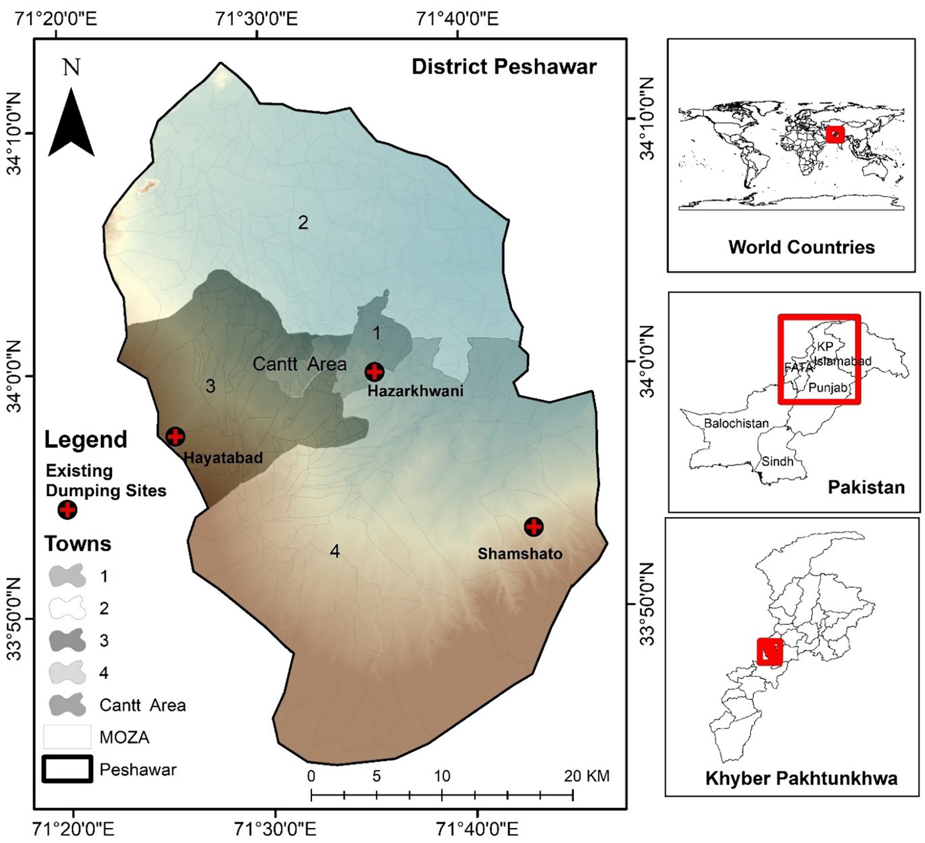
Study area map (district Peshawar, Pakistan). The Hazarkhwani dumping site is already closed by the district administration.
Datasets
Eleven datasets were acquired from various departments and each dataset was used as a criterion to identify suitable landfill sites in the study area (Supplemental Table A). These datasets/criteria cover environmental, social and economic factors which possess substantial importance in the landfill suitability analysis. Ground water data was obtained from Public Health Engineering Department Peshawar, soil texture data from Institute of Geographical Information Systems, National University of Sciences and Technology, Pakistan (IGIS NUST)/Soil Survey of Pakistan, surface water, railway lines and airport points from topographic sheet of the survey of Pakistan, aspect and slope from ALOS DEM while LULC settlements data were generated using Landsat 8 courtesy of the US Geological Survey (Date of acquisition: 6 June 2017). Road lines are digitized from Open Street Map and land value data was obtained from the District Administration Office Peshawar (Supplemental Table A). MCDA with the AHP technique was then used in ArcGIS 10.5 (version 10.5.0.6491) to generate a thematic map of each criterion (see details below). Thereafter, weighted linear combination (WLC) was used to identify the final suitable landfill sites for the study area. A flow chart of the methodology adopted in this study is given in Supplemental Figure A.
Supervised classification of the satellite image
A Landsat 8 image of the 6th June 2017 (Landsat-8 image courtesy of the US Geological Survey) was downloaded and the study area was clipped and preprocessed in Erdas Imagine (version 13.00.00 Build 281, ©1990–2012 Intergraph Corporation). Geometric corrections in the image were rectified, and errors were removed to make it suitable for the supervised classification. Signature files were prepared with four main classes named; Built-up, water, vegetation and bare land, and then a LULC map was generated (Supplemental Figure B). The supervised map was evaluated through accuracy assessment report and kappa statistics. The final generated LULC map was processed and used as one of the criteria in the LSS process.
Multi-criteria decision analysis
MCDA is one of the acceptable techniques for LSS (Ali et al., 2021). Hence, in this study, to reduce the environmental, social and economic impacts, the eleven datasets/criteria from the three broad groups were selected such as ground water, soil type, surface water, LULC and aspect (environmental), roads, settlements, airports and railways (social) and, land value and slope (economic). They were individually classified into two ranks that is factors and constraints. The factor criteria were further subdivided into five ranges or media types from unsuitable to very highly suitable. Hence, each criterion was ranked from 1 to 5 (1: constraints/unsuitable; 2: low suitable; 3: moderately suitable; 4: highly suitable; 5: very high suitable). Surface water, roads, settlements, airports and railways were considered as constraints for the construction of landfill sites due to their adverse impacts on the public health and the environment, hence, buffer zones ranging from constraint to very highly suitable sites were applied (Barakat et al., 2017). Since the ground water level and land values were point data, the inverse distance weighted interpolation technique was applied to interpolate their values for the entire study area. The selection of criteria and their distribution as environmental, social and economic criteria were based on the literature review (Fernandez et al., 2021) and its significance in the study area (Table 1). The detailed description and significance of each criterion is also discussed below.
All environmental, social and economic criteria and their suitability ranges.
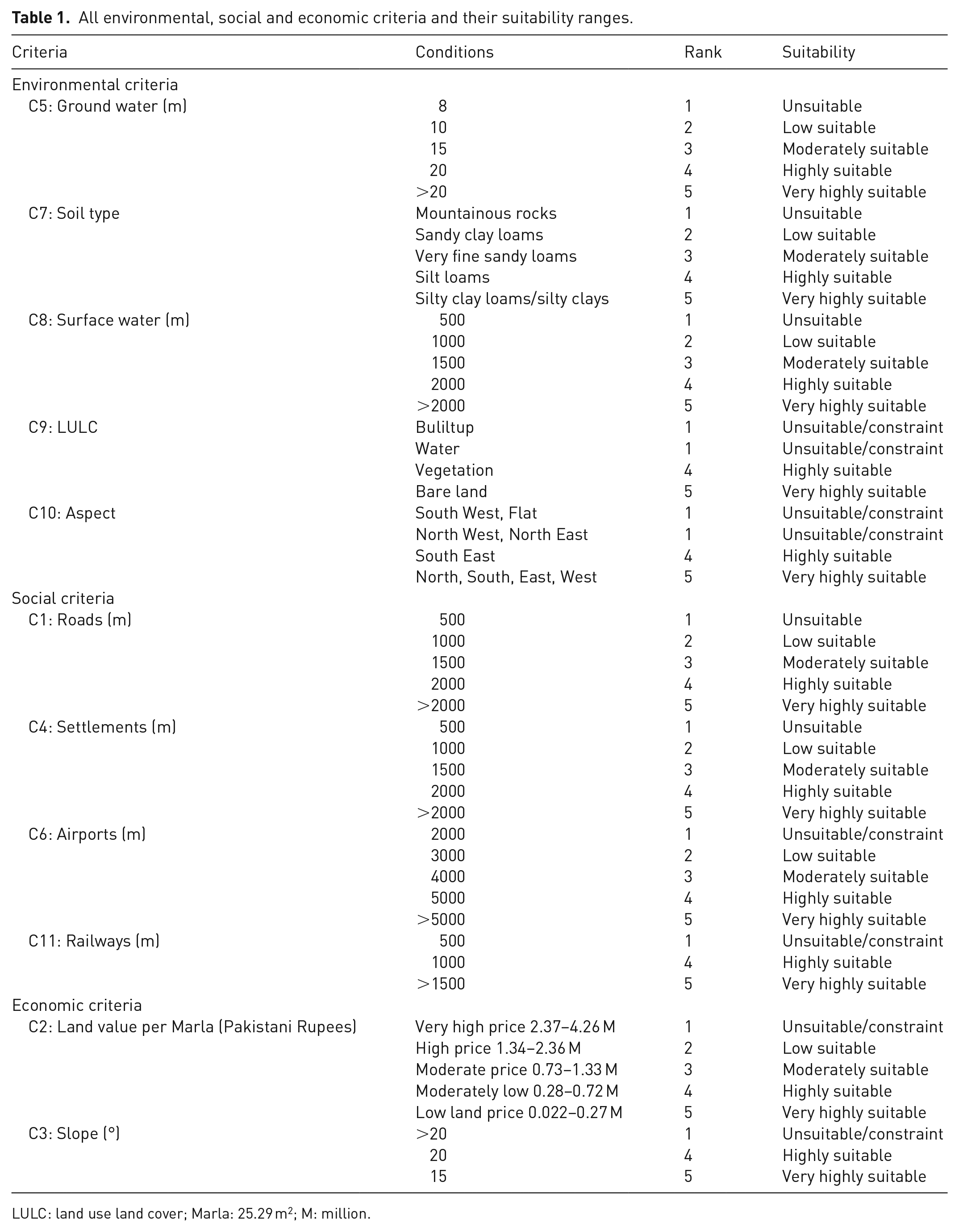
LULC: land use land cover; Marla: 25.29 m2; M: million.
Environmental criteria
Figure 2 shows the environmental criteria and Table 1 describes its suitability ranges. It includes ground water which is one of the most important environmental criteria because it is a significant source of drinking, irrigation and inflow to rivers and streams (Siebert et al., 2010). Leaching from landfill sites could contaminate ground water resources which would ultimately affect the population living in that vicinity (Ahmad et al., 2021), therefore, it is essential to conserve this precious water source from the infiltrated contamination (Adnan et al., 2019). A minimum 3 m water table from the surface is mandatory for the suitable LSS (Islam et al., 2018; Kharlamova et al., 2016). The deeper water table has less chances of ground water pollution because the contaminants need a longer travel time to reach the water table (Adnan et al., 2018; Shahab et al., 2018). Thus, areas with a ground water table greater than 20 m below the ground were suitable and less than 8 m were unsuitable for LSS. Soil type is also an important criterion for the LSS process because it prevents the leaching and contaminants infiltration from landfill sites below the ground surface. Ground water is at risk due to the infiltration process (Mallick, 2021) and with low porosity, there would be fewer chances of leaching. Therefore, sandy loams which are high porosity soils were considered low suitable while silty clays which are low porosity soils were very highly suitable within the study area (Mănoiu et al., 2013; Rathore et al., 2016). Along with the ground water conservation, surface water features should also be protected from the contamination of the landfills, and for this reason, a minimum 500 m buffer was applied as constraint/unsuitable while >2000 m was considered as very highly suitable for LSS (Islam et al., 2018; Şener et al., 2010). Landfill sites should not be located within the proximity of built-up areas while vegetation and bare lands are highly and very highly suitable for LSS (Barakat et al., 2017), therefore, a LULC map was generated and used as an environmental criterion (Supplemental Figure B and Figure 2(h)). The landfill areas emit unpleasant odours as well as dust which can easily be carried away to the outskirts of the landfill sites especially towards the settlements, hence, the wind direction was considered substantial to prevent the residential areas from odour and dust particles. An aspect map was generated to evaluate the wind direction of the study area (Barakat et al., 2017; Kontos et al., 2005). This aspect is important to keep the population away from unpleasant odours and dust from landfill sites (Eskandari et al., 2015). Hence, landfill sites should not be constructed in the direction of dominant winds (Şener et al., 2010). As the most dominant directions of winds in the study area are north to the west followed by north to east and south to the west (Khan et al., 2013), therefore these directions were considered constrained/unsuitable and given a score of 1, while the South East was considered as highly suitable with score 4 and, north-south and east-west wind directions were considered very highly suitable and were given a score 5.
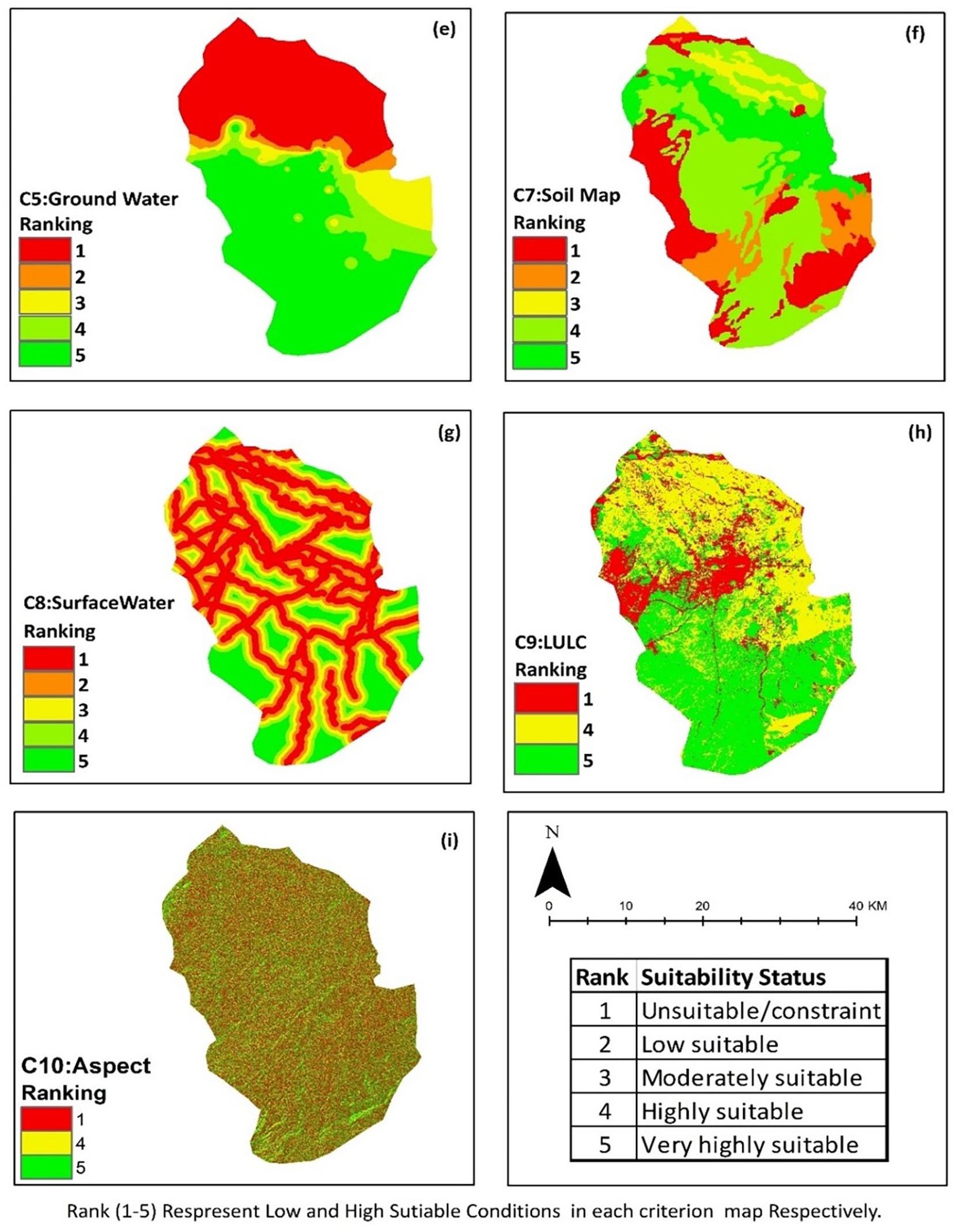
Maps of the environmental criteria (e: ground water; f: soil; g: surface water; h: LULC; i: aspect) with their suitability ranges.
Social criteria
To avoid the construction costs and select effective and efficient routes for the waste transportation, roads were selected as a social criterion (Kara and Doratli, 2012). Various studies have suggested optimal routes for solid waste transportation that can reduce the transportation cost by 20% in Greece (Karadimas et al., 2007) and 16.31% in Onitsha Nigeria (Ogwueleka, 2009). Therefore, road is an important criterion for LSS. Due to the congested road networks and heavy traffic routes all around the area, 500 m buffer was considered unsuitable and >2000 m was selected as very highly suitable (Wang et al., 2009). Similarly, distance to settlements was used to avoid public health risks because landfill sites release toxic air pollutants and unpleasant odours which make it unfavourable for the residents around them, and in the long-term, the leaching of the contamination could also pollute the ground water resources (Islam et al., 2018; Kara and Doratli, 2012). From the aesthetic point of view, landfill sites should not be constructed near the settlements, therefore, a minimum 500 m buffer was applied around the built-up area and considered as unsuitable while >2000 m was considered very highly suitable (Abediniangerabi and Kamalirad, 2016; Şener et al., 2010). For the safety and other possible effects of landfill sites like odour and noise that might cause inconvenience for passengers or landfill sites to attract birds that create risks for the aeroplanes, distance to the airport was included in the LSS, and a buffer <1500 m was considered unsuitable for LSS (Djokanović et al., 2016; Siddiqui et al., 1996). Distance from railway lines was also selected due to esthetically unpleasantness and for the durability and maintenance of railway tracks. 500 m buffer was applied as unsuitable around railways lines (Alanbari et al., 2014; Islam et al., 2018). More descriptions of the social criteria are given in Table 1 while the maps are presented in Figure 3.
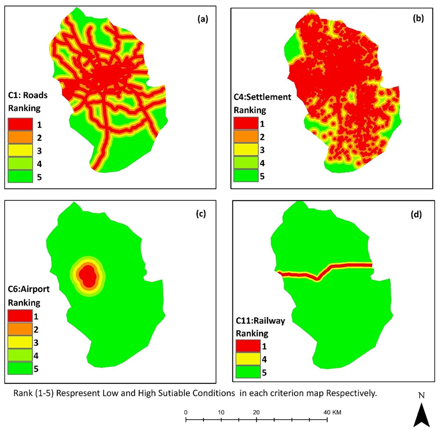
Maps of the social criteria (a: roads; b: settlements; c: airport; d: railways) with their suitability ranges.
Economic criteria
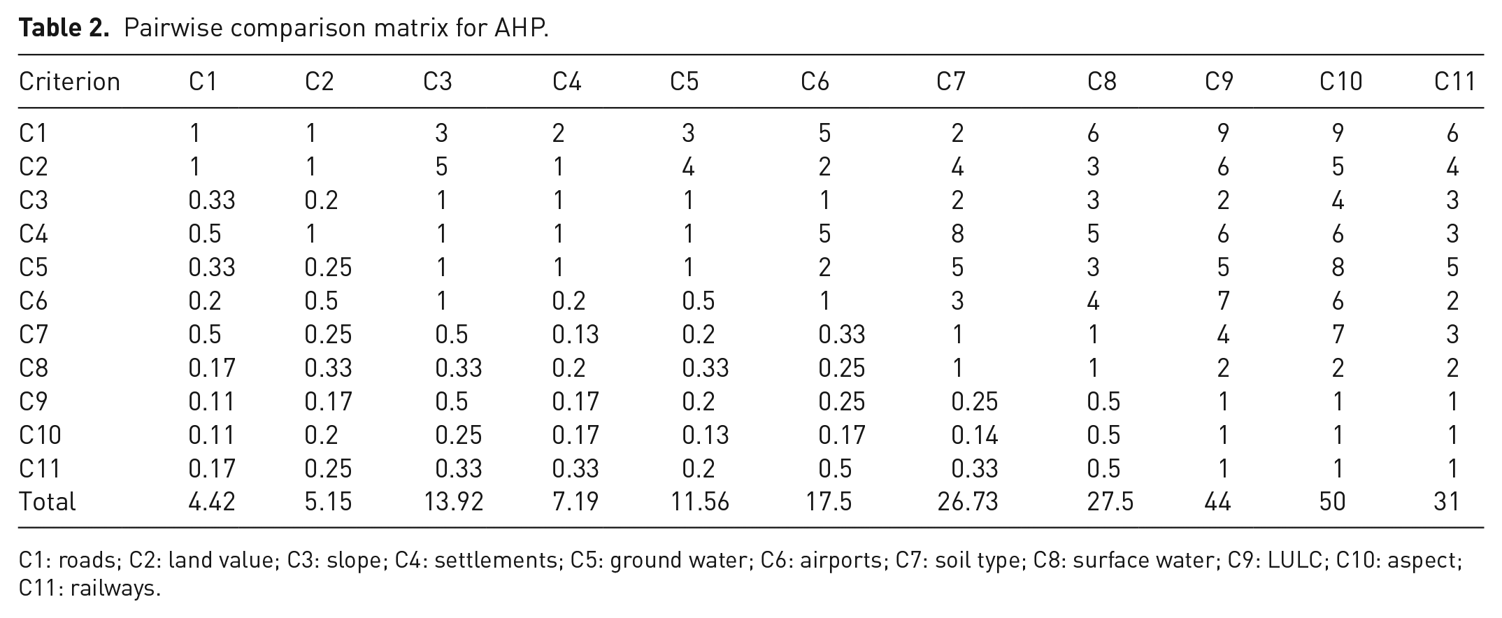
Land value and slope were used as economic criteria as shown in Figure 4 and Table 1. Slope is a basic economic parameter in the LSS process as steep slopes affect the excavation cost. Landfill sites cannot be built at high altitudes and slopes while areas with medium slopes and heights are suitable for landfills. Therefore, a slope >20° was considered as unsuitable, and 15° was very highly suitable for the LSS process (Alanbari et al., 2014; Şener et al., 2010). Similarly, lands with high economic values (>2.73 million Pakistani Rupees (approximately US$ 26,000) per Marla (25.29 m2)) were considered unsuitable while low economic values (<0.27 million Pakistani Rupees (approximately US$ 2570) per Marla (25.29 m2)) were suitable for the LSS (Costello and Polasky, 2004).
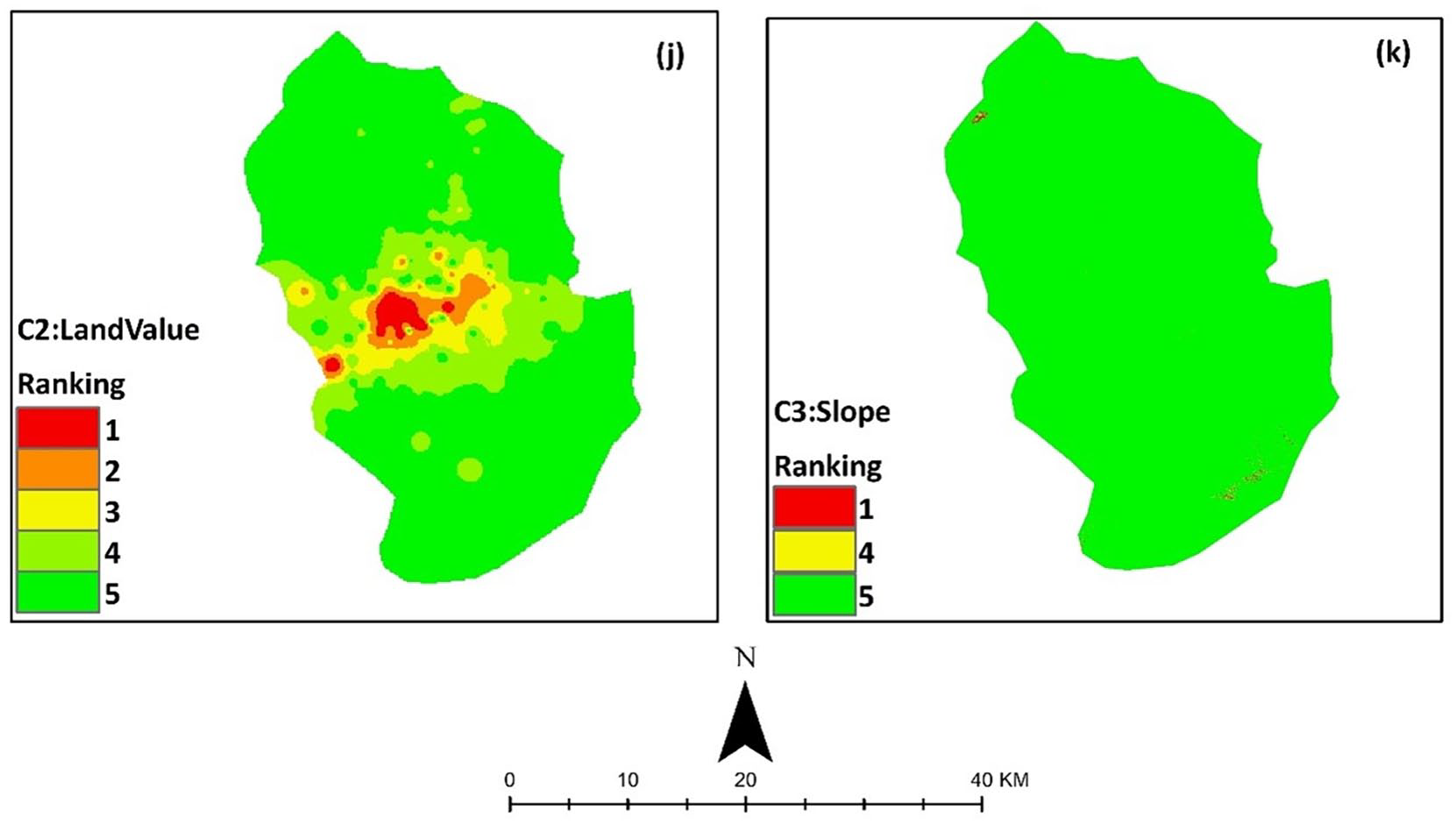
Maps of the economic criteria (j: land value; k: slope) with their suitability ranges.
Analytical hierarchy process
AHP is a MCDA technique that is currently considered as one of the low-cost approaches (Baiocchi et al., 2014) and widely used powerful tools (Redjem et al., 2021) to analyse difficult and complex problems in a logical hierarchical manner and helps the decision-makers to set priorities and make better decisions (Şener et al., 2010). Due to the complex nature of the data, AHP was used to interpret all criteria and find out the best locations for landfills in the study area. The algorithm adopted for the current research study was the AHP in which a comparison matrix was prepared and the importance of each criterion over the other criteria was categorized and weighted (Table 2). Weights were chosen by extensive literature research and after interviewing the relevant departments and stakeholders. The score to check the acceptable consistency of weights assigned was also kept in mind. The geographical dynamics which are also important for criterion weights were also considered. For comparison, a nine-point scale of preference named as Saaty’s proximity scale (Saaty, 1996) was used where 9 to 1 represent extreme importance to no-importance (equal importance), respectively (Supplemental Table B). Based on Saaty’s proximity scale, the comparison matrix represents the independent importance of each criterion in the decision-making process for LSS. During criteria scoring in the comparison matrix, distance from settlements, land value and roads were given more priority while the distance from railways and aspects were given less priority in accordance with their significance and importance in the LSS process as well as the environmental, social and economic conditions of the area.
Pairwise comparison matrix for AHP.
C1: roads; C2: land value; C3: slope; C4: settlements; C5: ground water; C6: airports; C7: soil type; C8: surface water; C9: LULC; C10: aspect; C11: railways.
The validity and consistency of the comparison matrix were then evaluated using equations 1 and 2 (Islam et al., 2018). In the first step, the consistency index (CI) was calculated using equation 1, where
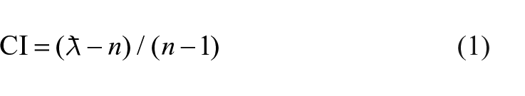
In the second step, the consistency ratio (
According to Islam et al. (2018) and Şener et al. (2010), the acceptable level of
Weighted linear combination
The final landfill site suitability map was generated by one of the WLCs tools in ArcGIS 10.5 (version 10.5.0.6491). Weighted sum analysis was used which combined and overlaid all the eleven criteria with their assigned AHP weights (Aydi et al., 2013; Mahini and Gholamalifard, 2006). To apply WLC, the prior requirement was to calculate the weightage of each criterion using the AHP comparison matrix (section Analytical hierarchy process). The numeric ranges of each criterion with the combination of weighted average were used in WLC where each weight was multiplied directly with respective criteria and then summed the overall multicriteria. The results must be in the range of 0 to 1 or close to one in a raster format. The following equation was used to apply the WLC for the landfill site suitability analysis (Drobne and Lisec, 2009; Mahini and Gholamalifard, 2006) in the study area.
where
For the reliability and applicability of the proposed model, it is important to mention that this MCDA technique is mostly knowledge-based as the weights are assigned after a complicated comparison process using an extensive review of literature, consulting experts and keeping in mind the priority factors of a particular geographical area. Hence, the reliability and subjectivity are the particular characteristics of MCDA and the results can easily be interrupted based on the made assumptions. GIS-based analysis minimizes the margin of error and the time in the originality of the adopted technique of MCDA.
Results and discussion
In developing countries, MSWs and suitable landfill sites in urban areas are some of the major reasons that degrade the environment, deteriorate the water resources and adversely affect human’s health (Ahmad et al., 2021; UNDG, 2016). To overcome these adverse consequences, landfill sites must be situated far away from densely populated areas and should be designed according to modern scientific knowledge that could protect the environment and human health. Similarly, the landfill sites must be close to the existing road networks to save the road developments and, the waste collection and transportation costs (Issa and Shehhi, 2012). Peshawar is one of the most urbanized areas of Pakistan where 1331 tonnes (0.38 kg per person) per day of waste is generated (Aatif and Arbab, 2015). The four different authorities (MC, PDA, CDA and WSSP) which are responsible for the waste collection use the same old-fashioned methods such as open dumping and burning of the waste. There are three dumping sites on the outskirts of the district (Figure 1). The two dumping sites (Hayatabad and Shamshato) still exist but they are situated within the unsuitable areas (Figure 5) while the 3rd dumping site (Hazarkhwani) is already closed by the district administration (Rafiq et al., 2017). Due to the unsuitability of the existing landfill sites and increased population growth, there is a dire need to establish new landfill sites based on GIS knowledge and tools as opposed to the old fashioned methods. MCDA and AHP within the GIS is one of the most sophisticated tools that integrate various criteria (environmental, social and economic) and select the most suitable sites for landfills that could have the least health risk to the population and environmental degradation (Eskandari et al. 2015; Islam et al., 2018; Malczewski, 1999; Rahmat et al., 2017).
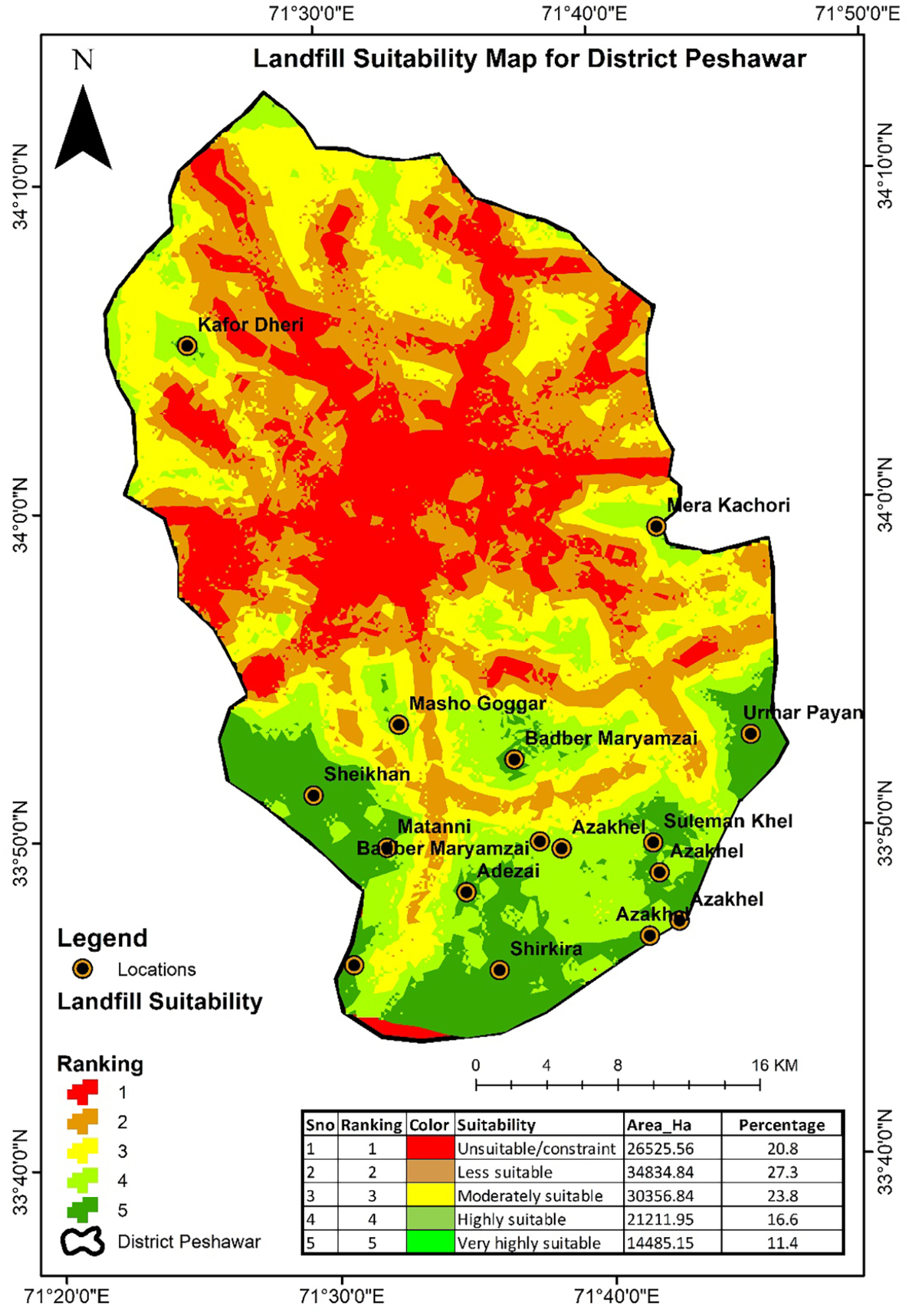
Landfill site suitability map as a result of the WLC.
Landfill site suitability analysis
Criterion weights using AHP
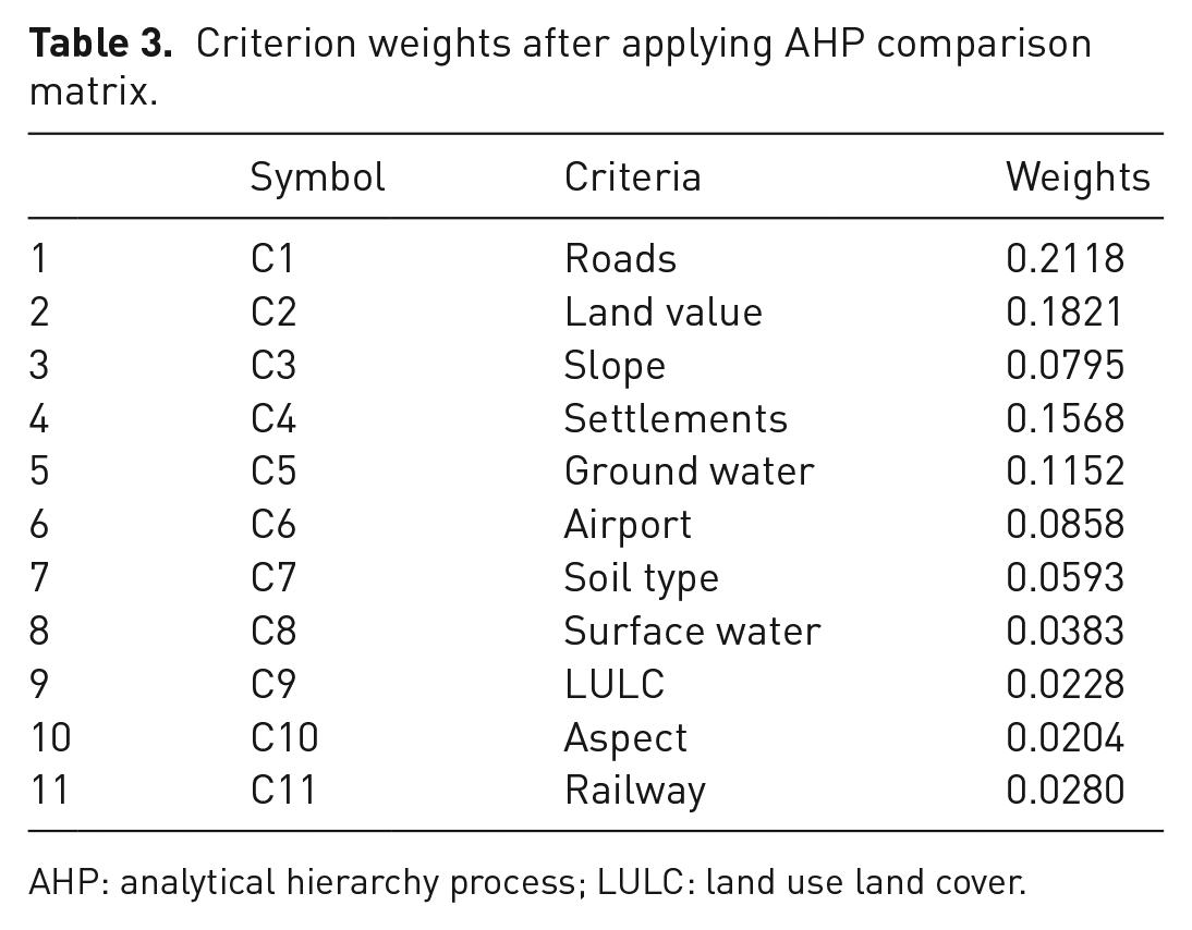
The normalized comparison matrix of the eleven criteria developed using the AHP method is shown in Table 3. The calculated weights of the environmental criteria were 0.1152, 0.0593, 0.0383, 0.0228 and 0.0204 for the ground water (C5), soil type (C7), surface water (C8), LULC (C9) and aspect (C10), respectively. For social criteria, the weights were 0.2118 for the roads (C1), 0.1568 for the settlements (C4), 0.0858 for the airports (C6) and 0.028 for the railways (C11). The calculated weights for economic criteria were 0.1821 for the land value (C2) and 0.0795 for the slope (C3). The normalized sum of these weights is 1 which denotes the validity and accuracy of the weights. The highest score in the AHP comparison matrix was given to the roads, settlements, land value and ground water because roads affect the operational and construction cost of landfill sites by providing the accessible routes for waste transportation during all weather conditions and are also important for their aesthetic value (Islam et al., 2018; Wang et al., 2009). Settlements are prioritized due to the public health risk, and, aesthetic and odour issues (Islam et al., 2018; Kara and Doratli, 2012). Land value is the best way to get public acceptance for the utilization of unwanted areas as landfills. For landfill site development, people show less resistance to the low-value lands as compared to the high-value lands (Asif et al., 2020; Pasalari et al., 2019). Protection of ground water by leaching from landfill sites also has a significant importance over the other criteria (Alanbari et al., 2014; Kharlamova et al., 2016). Hence, the computed weights for these criteria were more in comparison to the railways, aspect and other criteria.
Criterion weights after applying AHP comparison matrix.
AHP: analytical hierarchy process; LULC: land use land cover.
Suitability map using AHP and WLC
In MCDA, an analytical approach known as WLC was adopted for the LSS process. The results of the WLC were combined with AHP and a final suitability map was generated which ranged from 0.24 to 0.985 where the most suitable range was 0.838 to 0.985. The generated suitability map was classified as unsuitable/constraint area, low suitable, moderately suitable, highly suitable and very highly suitable land which respectively occupy 20.8% (26,526.56 ha), 27.3% (34,834.84 ha), 23.8% (30,356.84 ha), 16.6% (21,211.95 ha) and 11.4% (14,485 ha) of the total study area. It is important to mention that the selected sites are only for nonhazardous MSW while hazardous waste like the hospital, pharmaceutical and other industrial toxic wastes must not be disposed of in the proposed sites. The waste can be called hazardous or nonhazardous when the ‘dangerous substances’ are at or above certain levels (Inglezakis and Moustakas, 2015). According to European Commission (2000), hazardous waste is a waste that possesses one or more hazardous properties such as explosive, flammable, highly inflammable, toxic, ecotoxic, oxidizing, corrosive and infectious. The final landfill site suitability map of district Peshawar is shown in Figure 5. The majority of the population is living in the centre of the district which is unsuitable for the landfill sites and highlighted as red colour. The existing landfill sites as shown in Figure 1 are also located within the unsuitable areas which must be relocated to suitable areas identified in this study. In various union councils, the suitable areas for landfills are 3603.68 ha, 3851.7 ha, 1275.32 ha, 413.58 ha, 375.54 ha, 155.27 ha and 294.98 ha in Sheikhan, Shirkira, Urmar Payan, Azakhel, Suleman Khel, Matani and Adezai, respectively. These suggested landfill areas in the Figure 5 are mostly located within the plain areas, far away from the urban centre and where the depth to the groundwater is more than 20 m (Figure 2). Landfill sites in these areas would have the least effects on the environment as well as human health and could be safely used by the four authorities (MC, PDA, CDA and WSSP) operating in the Peshawar district for waste disposal.
Conclusion
MSW is one of the challenging issues for the waste management authorities of Peshawar district due to urbanization and population growth. The current study was an effort to minimize environmental degradation and public health risks as open dumping is a commonly occurring phenomenon in the study area. As district Peshawar has been urbanized at a rapid rate in decades, the selection of suitable landfill sites is a crucial phenomenon there. The LSS process has been accomplished in two major steps. First, the most effective environmental, social and economic criteria were identified such as ground water level, soil type, LULC of the area, distance to surface water features and aspects of the area (environmental), distance to roads, settlements, airports and railway lines (social), land value and slope of the area (economic). Second, the selected criteria were prioritized using a comparison matrix of the AHP and WLC to generate the final landfill site suitability map. About 11.4% (14,485.15 ha) of the total study area is computed as very highly suitable, 20.8% (26,525.56 ha) area is constraint/unsuitable for the construction of landfill sites and the remaining areas are either low or moderately suitable for landfill sites selection. The proposed landfill sites have been identified with high accuracy to help the waste management authorities and decision-makers to solve the waste management and disposal issues in the study area with less public health risks and least chances of environmental degradation. This study suggests selecting new dumping sites or relocating the existing ones to suitable landfill areas identified here. Our study also supports the effectiveness of MCDA (integration of GIS with AHP) for the LSS process in district Peshawar, Pakistan. Hence, this research study offers the scientific validation of identified environmental, social and economic criteria and landfill site suitability analysis. This method of the site selection process, being time-efficient and cost-effective, can also be helpful for the identification of landfill sites in any other metropolitan and densely populated city.
Supplemental Material
sj-docx-1-wmr-10.1177_0734242X221124069 – Supplemental material for Identification and selection of suitable landfill sites using GIS-based multi-criteria decision analysis in the Peshawar District, Pakistan
Supplemental material, sj-docx-1-wmr-10.1177_0734242X221124069 for Identification and selection of suitable landfill sites using GIS-based multi-criteria decision analysis in the Peshawar District, Pakistan by Iftikhar Ali, Aneeza Islam, Syeda Maria Ali and Syed Adnan in Waste Management & Research
Footnotes
Acknowledgements
We would like to thank the Editor-in-Chief and reviewers for their valuable comments and suggestions for the manuscript.
Declaration of conflicting interests
The authors declared no potential conflicts of interest with respect to the research, authorship, and/or publication of this article.
Funding
The authors received no financial support for the research, authorship, and/or publication of this article.
Supplemental material
Supplemental material for this article is available online.
References
Supplementary Material
Please find the following supplemental material available below.
For Open Access articles published under a Creative Commons License, all supplemental material carries the same license as the article it is associated with.
For non-Open Access articles published, all supplemental material carries a non-exclusive license, and permission requests for re-use of supplemental material or any part of supplemental material shall be sent directly to the copyright owner as specified in the copyright notice associated with the article.