
Abstract
Many libraries in the Global South do not collect comprehensive data about themselves, which creates challenges in terms of local and international visibility. Crowdsourcing is an effective tool that engages the public to collect missing data, and it has proven to be particularly valuable in countries where governments collect little public data. Whereas crowdsourcing is often used within fields that have high levels of development funding, such as health, the authors believe that this approach would have many benefits for the library field as well. They present qualitative and quantitative evidence from 23 African countries involved in a crowdsourcing project to map libraries. The authors find benefits in terms of increased connections between stakeholders, capacity-building, and increased local visibility. These findings demonstrate the potential of crowdsourced approaches for tasks such as mapping to benefit libraries and similarly positioned institutions in the Global South in multifaceted ways.
Introduction
Libraries around the world are contributing a great deal to development but do not necessarily realize or advertise their work. As an example, Okojie and Okiy (2019) share compelling evidence from 38 libraries in Nigeria to illustrate how they are contributing to the country’s development agenda, yet library staff did not perceive what they were doing as “development.” As a result, such stories from Nigeria and many African countries to date are under-represented on the International Federation of Library Associations and Institutions’ (IFLA, 2020b) Sustainable Development Goals Stories map. This is symptomatic of an even greater problem that faces library systems in the Global South, and Africa in particular. In many countries, there is a lack of data culture or a systematic method of collecting data about library reach or impact (Lynch et al., 2020; Moahi, 2019). In some cases, the national library or related authorizing institution of a country does not even know how many libraries it has or where they are located. This creates challenges related to visibility, as libraries struggle to be recognized by local stakeholders (Elbert et al., 2012) and the wider development community (Fellows et al., 2012; Namhila and Niskala, 2012) as potential partners in this work.
In this article, we argue that crowdsourcing can help collect important library data in countries that have weak data-collection and governance systems, in order to overcome these issues of visibility. To make this argument, we focus on an evaluation of a crowdsourcing project that worked with librarians across 23 African countries to map libraries. The evaluation data, including a survey, focus group discussions, and individual presentations at a stakeholder meeting, demonstrated that the participants and library systems experienced benefits from crowdsourcing, including increased connections, capacity-building, and increased visibility.
While our case study focuses explicitly on collecting library location data within specific African countries, we argue that the approach could be generalized to collect other forms of library data, to collect data about other community institutions, and even to other locations in the Global South with similar challenges and needs. These findings demonstrate the potential for Global South communities to collect their own authoritative data to overcome gaps in official data sets and gain recognition for their work. Furthermore, the benefits of crowdsourcing reach beyond mere data collection to impact libraries and participants in positive ways. This suggests the need for more research to expand crowdsourced approaches to similar institutions in other locations in the Global South, in order to advance their visibility and build internal capacity for data-based advocacy.
Background
Literature review: crowdsourcing and mapping in libraries
Various technological advances have expanded public involvement in data, in terms of both production and consumption. Many of these advances relate to the emergence of digital networks and associated information and communication technologies, which have greatly expanded the human capacity for information production, storage, communication, and analysis (Castells, 2004). The reach, accessibility, and relative affordability of these technologies makes it easy for individuals to reach large and widespread audiences for very low costs (Benkler, 2006; Bennett and Segerberg, 2013; Bimber, 2007). This not only gives people more access to more sources of data than ever before, but also allows individuals to produce their own data even when they are not in an authoritative position. These new capabilities have produced a great deal of excitement around the process of crowdsourcing, defined as a method of engaging non-specialists in the completion of routine online tasks (see Howe, 2006). Originally introduced as a business concept for utilizing amateur labor at low cost, crowdsourcing has become increasingly popular across many domains for economizing budgets, disrupting traditional flows of knowledge, and democratizing knowledge production (Lievrouw, 2011). Naturally, crowdsourcing does not represent a panacea to all problems related to knowledge production, and the method has also been criticized as inefficient (see, for example, Causer et al., 2012), exploitative (see, for example, Ettlinger, 2016), and capable of reinforcing colonial power dynamics (see, for example, Omanga and Mainye, 2019; Young, 2019). Nevertheless, when designed carefully, the method has demonstrated great potential for expanding the role of non-experts in producing important data, in tasks ranging from archiving restaurant menus (Lascarides and Vershbow, 2014) to diagnosing malaria (Wazny, 2018).
Maps have proven to be a particularly powerful medium for crowdsourcing because they are both easily understood by non-expert data producers and provide a powerful visual framework for presenting data. Many crowdsourcing applications base their platforms around maps, allowing users to click that map to produce their own geospatial data. This map-based crowdsourcing process has generated great scholarly excitement within the discipline of geography, where it has gone by names including volunteer geographic information (VGI), neogeography, and others (see, for example, Elwood et al., 2012; Goodchild, 2007). Within the Global North, crowdsourced approaches have been used to map everything from environmental destruction to public health issues (Warf and Sui, 2010), and have also been the basis for new forms of political activism and civic engagement (see, for example, Elwood and Leszczynski, 2013).
The approach has been arguably even more impactful in the Global South, where it has proven useful for overcoming gaps in official data sources and information and communication technology services in times of crisis (Zambrano, 2014; Zook et al., 2010). Across Africa, crowdsourcing has been employed to map various phenomena, including election violence, agriculture support, outbreaks of disease, and response to natural disasters (United Nations Economic Commission, 2017; Yilma, 2019; Zambrano, 2014). Further, crowdsourced maps can be utilized as political advocacy tools by making small-scale efforts more visible to larger funding or political bodies in the Global South (Young, 2017; Young and Gilmore, 2017). Our work operates on similar hopes of connecting communities with the resources they need for institutional survival through elevating their visibility, as evidence shows that many libraries in Africa do not collect comprehensive data about themselves, which creates challenges in terms of local and international recognition (Lor, 2016; Lynch et al., 2020).
Whereas crowdsourced mapping is often used within fields that have high levels of development funding, such as health (see, for example, healthsites.io; also see Wazny, 2018), these developments have potentially significant benefits for the field of library and information science (McKinley, 2012). However, these developments have been most explored in the context of libraries in the Global North. In many instances, these crowdsourcing initiatives do not explicitly contain geospatial components, and crowdsourcing is generally described in terms of increasing user engagement and connecting libraries to communities. While the most detailed understanding of crowdsourcing comes from Estellés-Arolas and González-Ladrón-de-Guevara (2012), Holley (2010: 2; emphasis added) makes a helpful distinction in that “crowdsourcing relies on sustained input from a group of people working towards a common goal, whereas social engagement may be transitory, sporadic or done just once.” In this sense, libraries have utilized crowdsourcing to increase the usability of archival content (Lascarides and Vershbow, 2014; Severson and Sauvé, 2019), create and curate new content (Oomen and Aroyo, 2011), and transcribe and correct existing content (Holley, 2010), among many other varied applications. Crucially, crowdsourcing has proven a strategic way for libraries to overcome gaps in funding for public-facing projects—a need echoed by mapping-related initiatives as well (Koontz et al., 2004; Li et al., 2016). As Holley presciently states: Libraries and archives will never have the resources to fully do what they or the users want so crowdsourcing is an opportunity that should be seriously considered…[and] could prove to be the most useful tool a library can have in the future. (Holley, 2010: 19)
However, a review of the literature revealed that few studies have rigorously evaluated the impact of crowdsourced mapping as an effective tool for libraries. One prominent example is the New York Public Library’s (2020) Map Warper, aiming to digitally align historical maps in the archives with more modern geolocation data as verified by volunteers to visualize urban development over time. This project has been deemed “successful” in yielding numerous digitally verified maps, yet “participation, while consistent, has been more modest and confined to a specialist audience” (Lascarides and Vershbow, 2014: 117). As another example, Indiana University Bloomington’s Herman B Wells Library organized a “mapathon” to engage community volunteers in contributing to the Humanitarian OpenStreetMap in disaster-affected areas (Quill, 2018). Quill (2018) defines its success more in terms of social benefits to the community, specifying data and map literacy skill development as positive impacts, in addition to meaningful engagement between the volunteers. Other studies also point out challenges associated with crowdsourced mapping in library settings, including difficulty attracting volunteers, maintaining data quality, coordination, and issues related to technical literacy (Causer et al., 2012; Lascarides and Vershbow, 2014; Oomen and Aroyo, 2011; Quill, 2018). Even less is known about how these benefits and challenges affect libraries and librarians themselves, beyond the indirect benefit to patrons.
In addition, a vast majority of these reports are from library and information science settings in the Global North, where accurate geographic data may be more available, and more resources may exist for implementing and maintaining such efforts. On the one hand, crowdsourcing may be an even more powerful method for libraries in the Global South, given a lack of comprehensive data and data governance structures. On the other hand, some may think that the benefits described above are simply out of reach for libraries in Africa, given the perceptions of key stakeholders that libraries have limited Internet connectivity and less access to technological resources and skills (Elbert et al., 2012; Fellows et al., 2012). Given these challenges, the question remains as to whether crowdsourcing can benefit libraries and their stakeholders on the ground in Global South contexts.
This article, then, seeks to answer the following research question: What are the benefits of a crowdsourced approach to data collection for the library and information science field in the Global South?
Case study: mapping libraries in Africa
This article attempts to answer that question by evaluating the impact of a crowdsourcing project carried out by the Technology and Social Change Group, a research group at the University of Washington, and African Library and Information Associations and Institutions (AfLIA), an international non-governmental organization. This crowdsourcing, which was carried out within the program Advancing Library Visibility in Africa (ALVA), had the purpose of mapping public and community libraries across Africa as part of a larger effort to equip public libraries in Africa with knowledge and the tools to demonstrate their value as development partners through building capacity to collect and analyze data.
Through an early attempt to establish a baseline understanding of the landscape of public libraries across Africa, it became clear that the government agencies in most countries do not have data on the number or precise locations of their libraries. Other sources such as the ‘Library map of the world’, maintained by the IFLA (2020a), provide basic statistics of library numbers and types for each contributing country, but the specific library locations are not available, and no data is reported for many African countries. Therefore, the research team started a mapping project to map the specific location of all public and community libraries across Africa. The project seeks to collect this geolocation data alongside additional organizational data, with the goal of producing a map-based platform that can be used to connect libraries to potential partners. The idea was that the map could serve as a platform for development success stories and other community information desired by development organizations to further facilitate potential partnerships.
However, the lack of pre-existing data and ambitious geographic scope of the project necessitated a crowdsourced approach to mapping. In addition, the goal is for the platform to be sustainable and led by AfLIA in the long term. With these goals in mind, the team iteratively developed and tested a mapping platform that could be used by library sectors across Africa. The final platform (see https://librarysites.io/) is built on Esri ArcGIS Online Crowdsource Reporter, which is a template that can be easily adapted to produce custom online mapping services for facilitating crowdsourcing. When users open the application on their phones, the application prompts them to enter the location of a library either manually or through the use of an autolocation feature that leverages their mobile device’s GPS (Global Positioning System) utility, as shown in Figure 1.
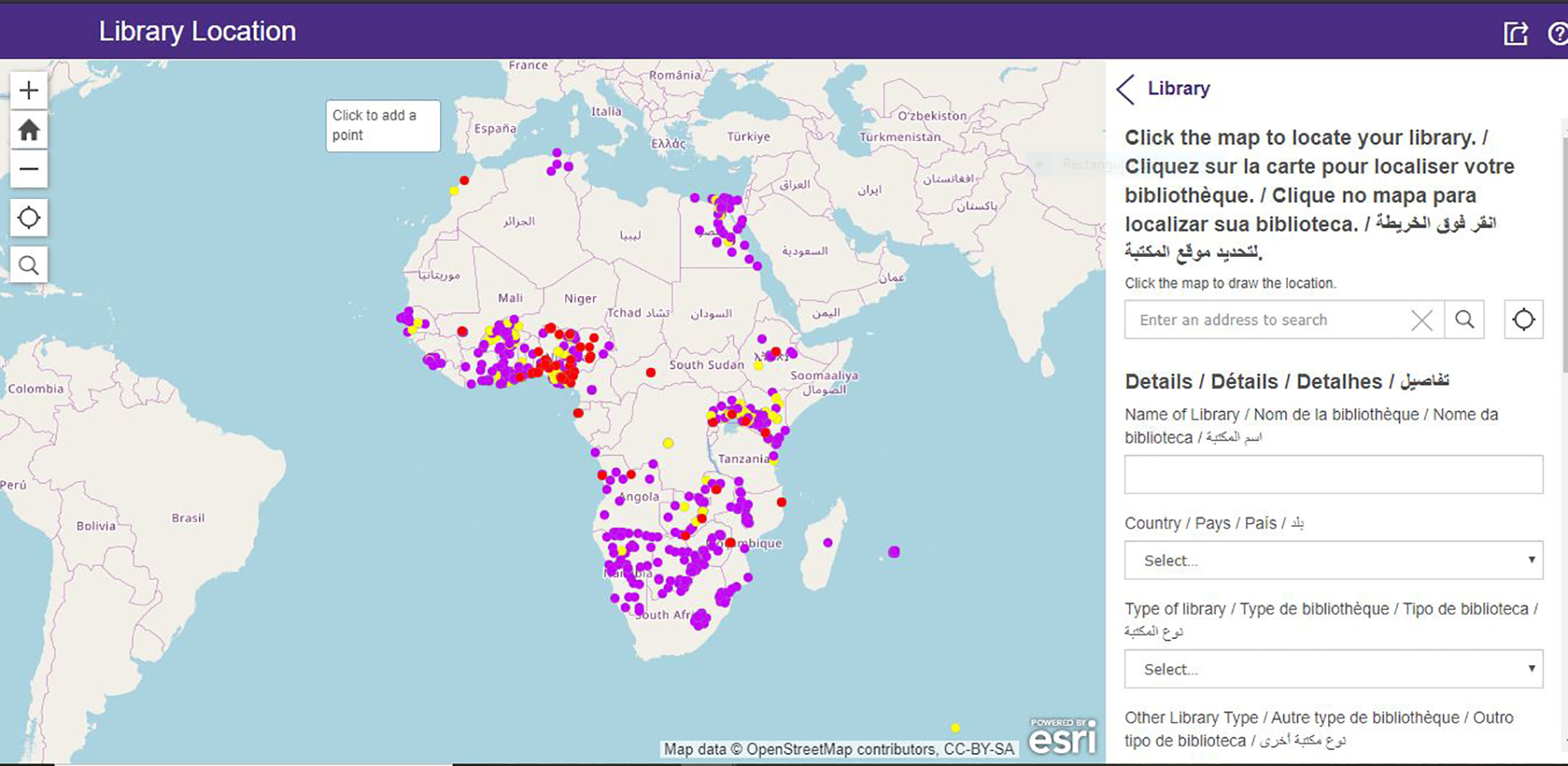
Mapping platform: location submission view.
In order to improve the accuracy of the submissions, we train librarians to use the autolocation feature and to submit information from the physical location of the library. The user is then prompted to enter the library name, its type (public, academic, etc.), and contact information for both the library and the user, with the option to submit a photograph of the library (see Figure 1). In the long term, ALVA has plans to add fields for additional library information, such as staffing, annual visits, and so on. To inform these additions, we are currently conducting a survey of in-country library staff concerning which types of data they collect in order to understand national data priorities and what data is currently available internally. We will work with national libraries to publish some of this data to the mapping platform to make it more visible and accessible. Concurrently, we are interviewing key informants from development organizations to determine what types of library data would be most persuasive to them. This information can inform in-country data-collection practices so that they can be adjusted to collect the desired information. The hope is that we can leverage our mapping platform to display these types of data in order to tell a powerful story about the role of libraries as development partners.
The geolocation is then verified by the ALVA researchers using a separate management system, built on the ArcGIS Online Crowdsource Manager, as shown in Figure 2. To complete this quality assurance process, we use a series of criteria to determine if the submitted location is likely to be accurate. For example, the platform allows administrators to use satellite imagery to verify that the submitted location is at or near a specific building. If these or other quality control measures have not been met, the submission is flagged, and a research team member communicates with the user for clarification. Once a library has been fully approved, it is displayed as “accepted” on the display map (http://display.librarysites.io) and can be viewed by anyone accessing the platform.
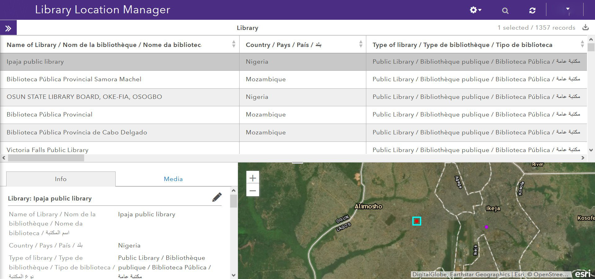
Mapping platform: library location manager view.
ALVA has also prioritized making the mapped data openly available and easily accessible, for both library stakeholders and the general public. The data set is available for download by any government or non-official entity via the Open Science Framework site (https://osf.io/685hm/), and this opportunity for downloading has been shared with project “Champions” as well as participating government ministers and national librarians at related events. For example, the ALVA team presented the mapping project to national librarians as part of the 3rd Ministerial Roundtable Meeting on Information Access in Accra, Ghana, in 2019. The goal of this presentation was to give the national librarians an update on the project’s progress, to give them the opportunity to increase their country’s participation in ALVA, and to share information about how they could access the data that had already been collected. At the meeting, there was great interest in exploring the ways ministers could support the data collection to realize the role of libraries in national development. We have also explored ways to leverage the existing open-source data platforms to increase the visibility of our work so that it has a greater impact. Because the library location data is licensed openly and can be used without attribution, we have been able to integrate it into other related projects such as Wikimedia’s FindingGLAMs platform (see https://meta.wikimedia.org/wiki/FindingGLAMs), which further increases the visibility of Africa’s libraries.
In order to facilitate the process of collecting and verifying the library data, the research team also determined the necessity of local “Champions.” These are in-country individuals who would be able to bridge the gaps common in similar projects in the Global South, such as limited access to technological infrastructure outside of urban areas and lack of widespread public interest, which crowdsourcing otherwise depends on (for more information on facilitated crowdsourced mapping in South Africa, see Cinnamon and Schuurman, 2013). Using the networks and expertise of AfLIA, we solicited well-connected library professionals who would be trained and paid a small stipend by the project to direct the data-collection efforts and promote participation among a wide range of librarians around their respective countries. This way, the mapping platform could be public-facing and available for anyone to contribute data while assisted by in-country Champions as they saw fit. For some Champions, this has involved training librarians via workshops and messaging applications; for others, it has made more sense to travel to library locations directly to map them. As of October 2019, Champions in 23 countries had agreed to participate; these Champions were trained by AfLIA and later invited to a stakeholder meeting to discuss the project, as described in the next section.
Methods
This section describes the methods we used to evaluate the impacts of crowdsourcing. They included a survey and focus group work with the Champions at a workshop in Accra, Ghana.
The 23 Champions who were actively contributing to the mapping were invited to participate in a Champions Meeting held in Accra, Ghana, for three days in October 2019. Twenty-two Champions participated in the meeting in addition to four researchers from the Technology and Social Change Group and AfLIA. The participants were library professionals from 23 countries across North, Southern, East, West, and Central Africa. All were asked and agreed to serve as the Champion for the ALVA project in their respective countries. The countries, names, and institutions of the participants are withheld here to protect their privacy. The participants gave their informed consent to be included in the study when they agreed to attend the meeting.
The overall purpose of the meeting was to share and examine the Champions’ experiences implementing crowdsourced mapping in their countries and to discuss ideas for the long-term sustainability of the project in their countries. Prior to the meeting, the Champions completed a survey about their experience contributing to the mapping work. At the meeting, the Champions gave individual presentations about their experiences and reflections on participating in the project. The Champions then discussed their experiences in focus groups and presented to the full group on their major themes.
The data analyzed here was collected from three sources:
A written survey, which was sent to all 23 Champions via an email link and completed in an online survey portal in the language of their choice (English, French, Portuguese, or Arabic). The Champions gave their informed consent to participate and were asked for either open-ended or categorical responses. The topics covered included background on the participant’s job within the library field; their prior experience with performing data collection in their job; the bureaucratic, technological, financial, or other challenges that they encountered while participating; the benefits from participation and the crowdsourced data; and ideas for making the project sustainable in their respective countries. Twenty-three Champions completed the survey.
Individual presentations, which were prepared in advance of the meeting by the Champions according to a presentation template that asked them to report on their adopted methods for facilitating crowdsourcing, the challenges encountered, the lessons learned, the benefits of participating in the project, and ideas for project sustainability. Twenty-two Champions gave individual presentations on the first day of the meeting.
Focus group presentations from four different focus groups composed of five to six individuals. The groups were formed by the research team based, first, on similarities in national language (English or French) and, second, on broad geographic region (West, Southern, Central, and East Africa) with the understanding that this would allow for ease of communication and sharing of regionally relevant insights, where applicable. After the individual presentations, the focus groups summarized and discussed the most salient financial, technological, and bureaucratic problems and benefits related to the project, and were asked to come to a consensus on the top three of each. One researcher was present with each group, and one individual from each group then presented their findings to the larger group on the first day of the meeting.
The data collected was in English, French, and Portuguese. During the meeting, interpreters were present to translate between English and French or Portuguese, according to participant needs. The data written in French or Portuguese was translated into English using Google Translate, and the French translations were reviewed by the researchers. The data was analyzed inductively and recursively using a grounded theory approach (Glaser and Strauss, 1967). For this article, the primary focus was on the benefits of crowdsourcing; therefore, initial codes around the idea of “benefits” were developed based on the analysis of the survey data. The researchers created codes based on the types of benefits that were commonly expressed by multiple participants across the data sources. These codes were then applied to the data from the individual and focus group presentations and revised on an iterative basis. The findings were triangulated across the data sources, and specific data points are provided here to illustrate both typical and outlying examples.
Findings: benefits
Our findings indicate that a majority of those participating benefitted from the project in some way. When asked in the survey “Have you, your organization, or the library sector of your country experienced any benefits, either direct or indirect, from participating in the project?” 83% of the participants responded “yes,” with only 17% responding “no.” Given the benefits explained by the participants, three main categories related to the crowdsourced nature of the project emerged: increased connections among various stakeholders, capacity-building, and increased visibility locally.
Increased connections
A strong overall theme of our findings was the influx of connections that had resulted from the crowdsourced mapping work. From the Champions’ responses, it is clear that they experience this platform as “an opportunity to establish contacts with librarians across the country and world,” as described in an individual presentation. Across the data sources, they spoke to creating new connections and strengthening existing networks as a result of taking a crowdsourced approach to mapping. These connections flourished between various groups of stakeholders.
Between librarians
In many cases, a crowdsourced approach resulted in increased connections between librarians. At the outset, the Champions had to find or create listings of libraries for contacts in order to solicit librarians and library locations to participate. Several of the Champions noted that no database or listing of library locations, staff, and contact information had existed in their countries prior to the launch of this project. To facilitate an open call—a key feature of a crowdsourced approach—the Champions had to collect contacts to create a Facebook group, WhatsApp group chat, or other type of forum to solicit librarians en masse. This is illustrated by an example survey response that a major benefit of the project was the “creation of several formal and informal communication networks of library staff on social media.”
These increased connections between librarians are leading to collaboration and increased motivation among library staff, as indicated by the Champions. As one focus group noted, the “project has provided a forum and inspired librarians to come together for sharing of ideas among librarians.” Additionally, in the survey, a Champion reported: “Librarians are positing/sharing information on the communication platforms—such as library events, happenings, studying opportunities, funding opportunities. Others are eager to list the library on the platform, to be visible just like others.” This also implies that being included in a visible professional network may also have been a built-in motivating factor for librarians to participate in the mapping activity. This corresponds with an example comment from an individual presentation, explaining: “Seeing other libraries listed—librarians are eager to ensure that their libraries are listed on the ALVA platform too.”
The Champions noted that these connections resulted in concrete ongoing benefits for librarians themselves. As an individual presentation asserted, “Contacts have been established between colleagues, which augurs well for future cooperative efforts in the face of challenges in the profession,” with specifics mentioned such as awareness of opportunities for funding, as stated above, and mentorship, which was ranked as a top benefit by one focus group, describing a “mentoring forum for young librarians to be connected with senior librarians to meet.” This is echoed by a survey response which noted that the project had “formed mentorship forums for struggling community libraries.” While the intention of the original project was to increase connections between libraries and development partners, the connections fostered between librarians have gained significant value for the participants themselves.
Between libraries and their stakeholders
Within the wider library landscape of the Champions’ countries, it seems that the crowdsourced nature of the project is connecting libraries with a variety of community actors, from different types of libraries (for example, “Direct benefits include getting to know all the different libraries available in the country and meeting some of the librarians working in these institutions,” from an individual presentation) to library users (for example, “Our direct collaboration with library managers allowed us to discover and understand certain challenges of public reading in [the country],” from an individual presentation). This visibility also extends to AfLIA as a stakeholder. As stated in a survey response: “Librarians now know each other better and they now appreciate AfLIA.” This suggests increased connection to members and potential members facilitated by this process, and even other libraries on the continent, as shared in an individual presentation: “we are able to access library locations of other public and community libraries from African participating countries and compare with our own.”
This was underscored by a strong sense among the Champions that the connections fostered by this project would be useful for strategic relationships in the future. For example, in an individual presentation it was expressed that: “The data collection will serve as a tool and argument for advocacy with those in government for the involvement of public and community libraries in actions, programs and development projects at national and institutional level.” This is accompanied by a focus group comment, which named the “opportunity for networking within local and international institutions” as one of the top benefits of participating in the project. Likewise, another focus group elucidated: “Submission of report and partnership with external organizations.” Overall, this represents a wider set of stakeholders than was initially imagined in the mapping project, and these benefits are intimately tied to increased local visibility.
Capacity-building
Due to the crowdsourced approach, this work is also building various capacities among the participants. The Champions see the connections it facilitated as a factor in increased professional capacity, as illustrated by the following point from an individual presentation: “The project has enriched our contact networks and provided avenues for overcoming challenges on the ground.” This was especially salient for three groups: librarians, Champions, and their organizations.
For librarians
Overall, the Champions described the benefits to librarians in terms of new technical skills gained in the process, as narrated in an individual presentation: “Librarians in public libraries benefitted immensely by learning new skills. They noted that they had never participated in such a project and were happy to be a part of it.” Additionally, a survey response emphasized that the project provided a “great opportunity to train librarians on how to locate their libraries on the map. The librarians improved their skills and some were excited to be part of a global research.” Such responses imply that librarians are learning more about mapping, as well as the process of international research, as a result of the crowdsourced methodology, which they find valuable in their contexts.
For Champions
Also notable to the research team was that the Champions were able to gain professional experience that was of high value to them as a result of their participation. The survey found that a majority of the Champions (65%) had not participated in other data-collection projects in the past five years and, from their responses at the meeting, it was clear that much was gained from this opportunity.
Many of the Champions framed the benefits of the project in terms of increased awareness of the library terrain in their countries, as described by an individual in their presentation: It gave me a better insight into the state of public libraries and the library field in [my country]. It provided the opportunity to identify the skills gaps of librarians in public libraries, especially in data collection practices and use of the Internet.
Additionally, the Champions reported that they themselves had learned new and valuable skills, as three of the four focus groups mentioned increased skills for the Champion as a top benefit of participating. This was asserted in an individual presentation: “The skills in engaging with the survey and platform are priceless.” The specific skills cited included using technological platforms such as Zoom for communicating and ArcGIS for submitting data, as well as “Development of my art of convincing” (from the survey)—presumably in negotiating with managers and recruiting participants for the project. In addition, the Champions reported flexibly responding to the challenge of engaging library staff with varying levels of capacity. They reported a number of creative ways to teach and troubleshoot the mapping platform, such as holding in-person workshops, discussing issues over the phone, sending screenshots for training via WhatsApp, and creating videos in local languages that were shared on YouTube. It was common for the Champions to engage multiple modes of communication for various contexts in their countries.
The Champions conveyed that these skills plus knowledge fuel an increased capacity to serve as leaders in future research. As two individuals noted in their presentations, “For us Champions, this is an experience that will serve us in professional life and allow us to lead other national or international projects” and, more emphatically, “Our participation in this project as Champion gives us the experience, the tools and the contacts necessary to lead other projects of national scope in the field of libraries.” As one concrete example, a Champion mentioned that the contacts and insight gleaned from participation in this project were utilized for their own research, which was then presented at an international conference. As an overriding sentiment, another Champion expressed in their presentation that: “The travel to these places opened another horizon and interest in working towards availing information for access to all.”
For organizations
Across the sources, the Champions shared that the contact information gathered as a result of crowdsourcing would be dually used to update the databases of their national libraries and associations. The information then provided for new possibilities for the organizations, as illustrated by this survey response: “The project has helped us to know who is in charge of a particular library and where they are located; this has helped in terms of coordinating issues and getting the statistics right.” Additionally, as stated in an individual presentation: “The data collected from the project is a source for the national association in making decisions and setting up similar projects.” This data was noted by many Champions across the sources as having the value of being “accurate” and “reliable,” in addition to being updated, enabling a growth in capacity for their organizations, such as in the “training and development of the library fraternity,” as shared in an individual presentation.
Increased local visibility
The findings also indicate that our crowdsourced methodology increased the visibility of the project locally for libraries and their Champions. For instance, a Champion who attended the meeting reported that some librarians have taken the initiative beyond the platform to add the location of their libraries on Google Maps and Facebook (Here WeGo maps), having become more aware of, exposed to, or trained on how the visibility of their libraries can be enhanced through GPS mapping. In fact, the library authorities of certain countries have now decided to simultaneously add the locations of their public libraries on Google Maps while providing data for this project.
In addition, participation has raised visibility for libraries at higher levels of local governance. A significant portion of the Champions (52%) reported in the survey that they needed to get permission to participate in our project, often from a superior, and there was a general trend among the survey responses for the Champions to start at the top of local bureaucratic hierarchies (such as a minister or local authority) to secure their permission before proceeding with the data collection. While this could be perceived as an extra challenge, it also appeared as a benefit in that this mapping work reflected well on the library sector. As shared in an individual presentation: All institutions contacted for this project and their personnel know that their libraries have more value than they expect (awareness of the library importance). People are willing to know more how this will be beneficial to them (engagement to explore the sector).
Discussion
These findings indicate that both libraries and their stakeholders “benefit from [the] mutual recognition” (Oomen and Aroyo, 2011: 146; emphasis added) enabled by a crowdsourced approach. Although this mapping was undertaken to make libraries in Africa more visible to external partners, the Champions and librarians are now more visible to each other, as well as local stakeholders. These findings resonant with Holley (2010: 2), who states that crowdsourcing “demonstrat[es] the value and relevance of the library in the community” through wider involvement while simultaneously “improving the quality of data/resource[s].” For libraries and their Champions, these two seem to go hand in hand as more and better data collected via this project is seen as directly impacting the libraries’ social standing through increased visibility. As Quill (2018: 161) notes, this can empoweringly fill gaps in government or other authoritatively produced sources to “democrat[ize] the process of mapping, giving agency to lay people to literally put themselves on the map.” In this case, the crowdsourced approach to mapping is allowing the Champions and librarians to put themselves on the map and actively advocate for libraries as an institution in the process.
The findings also confirm that this project is truly “utilising the knowledge, expertise and interest of the community,” such that crowdsourcing builds “trust and loyalty” to the institution among the participants (Holley, 2010: 3). Further, the multifunctional role of the Champions is a reminder that, in the words of Wilken et al. (2019: 9), “[l]ocation technologies do not supplant but rather supplement forms of knowing place and location.” Our findings reflect that this project would not be as successful without the on-the-ground efforts of the Champions, which have mutually benefitted them. This work can serve as a counter-example to the negative experiences of Omanga and Mainye (2019), who report that the prime beneficiaries of crowdsourced mapping in Nairobi, Kenya, are actually “individuals drawn from a social network within NGOs [non-governmental organizations] working in the slums” (274) for whom “Africa is understood as…a mere source of primary data” (273). The positive effects enumerated by the Champions suggest that they, librarians, their organizations, and libraries as institutions are benefitting locally and will continue to benefit from this crowdsourced data-collection effort.
Our findings also resonate with Quill’s (2018) description of libraries as community spaces that build social connections. This was a common theme, which reflects that, as noted by Young and Gilmore (2013: 809), participatory forms of mapping can have benefits of an emotional nature: “In our case, [participants] demonstrated emotions like pride, bonded politically, and educated one another with different views on their shared history.” Oomen and Aroyo (2011: 146) also put crowdsourcing benefits in social terms, tied to user motivation for “connectedness and membership,” “sharing and generosity,” and “altruism, fun and competition.” These emotional benefits were not the focus of our original project but are clearly very valuable for the participants, their newfound networks, and ongoing research.
It is clear that a facilitated approach to crowdsourcing was integral to the realization of these benefits in the Global South context, similar to the experience of Cinnamon and Schuurman (2013). The Champions reported being able to act as intermediaries, which resulted in the capacity-building and increased participation of others. The Champions thus helped to fill gaps in technological skills, echoing Quill (2018: 164), who noted that it is advantageous to have a “facilitator” to “float around” and “individually assist” participants while conducting mapathons in the library space. Further, the local presence of the Champions allows for ongoing support, similar to Lascarides and Vershbow’s (2014: 117) observation that Map Warper “worked best when accompanied by hands-on training or situated residencies…that occur over multiple weeks.” Importantly, this also highlights that “allowing participants to work together on the map fosters discussion and allows more hesitant participants to engage in a less direct way” (Quill, 2018: 161; emphasis added), which is evidenced by the Champions’ reports of engaging reticent librarians and their managers. Holley (2010) and Quill (2018) support the fact that engaging in this work builds capacity in technology and literacy skills, which is, fittingly, a shared goal of many development organizations (Sears and Crandall, 2010), further highlighting that the library is a “natural home for this type of activity” (Quill, 2018: 161) and an important player in development. As a result, the role of the Champions can be seen as more analogous to “virtual community managers” who “nurture, stimulate, and moderate online interaction” between volunteers to ensure the success of a crowdsourced project (McKinley, 2012: 6). The Champions have proven a crucial factor for our project’s ability to map over 701 public and community libraries while simultaneously creating and strengthening networks that were leading to the further empowerment of library professionals in a total of 29 countries as of March 2020.
While the facilitated approach to crowdsourcing is a uniquely valuable aspect of our project, it does raise concerns about crowdsourcing and responsibilization in the neo-liberal climate of global development. In the increasingly fractured landscape of NGO and multilateral funding (see Ingram and Lord, 2019) that has rushed in to fill gaps in state budgeting for public institutions, left in the wake of western-driven structural adjustment policies, libraries themselves bear the brunt of efforts to appeal to other disparate sources (see Schnable, 2015; Stranger-Johannessen et al., 2014). The role of the Champion embodies this extra labor of connecting individual libraries to the elusive promise of funding. Although the Champions were financially compensated in this project and reported mutual benefits, their proven value leaves critical questions about the nature of labor in crowdsourcing and in the Global South, as well as long-term sustainability. Such questions are beyond the scope of this article, but our other reflections on this project (see Young et al., 2020) engage similar critical questions.
Conclusion
In reflecting on the quality of volunteered geographic data, Elwood et al. (2012: 580) remind us that “[i]t is impossible to create a perfect representation of any aspect of the geographic world—all geospatial data are of limited quantity”—and, ultimately, the power to decide the quality of such data lies in the hands of its users. Our findings have illuminated the ways in which the Champions and librarians across Africa are creating a locally authoritative set of data through their own crowdsourced efforts. Although the collection of this data was originally intended to facilitate connections with development organizations, the benefits of its crowdsourced approach have taken on a life of their own, increasing connections between librarians, Champions, and stakeholders; building capacity among librarians, Champions, and their organizations; and increasing local visibility. Overall, this reaffirms Young and Gilmore’s observation that maps are powerful, not only because of what they represent but also because the process of mapping forces communities to come together and think about how they share the stage of production, particularly with the inclusion of the spaces in which they live. (Young and Gilmore, 2013: 820)
We recommend the crowdsourced approach for similarly positioned institutions to mobilize the potential of Global South communities to collect their own authoritative data. As demonstrated by our findings, the benefits reach beyond the scope of data collection itself to profit contributors on the ground. We further recommend a facilitated crowdsourcing approach, mediated by individuals such as in-country Champions, as they were the nexus of many of the benefits we found, including building capacity among librarians as well as raising visibility among local stakeholders. Their labor should be recognized and remunerated where possible; at the very least, the work should benefit the participants in concrete ways, such as in expanded networks, professional experience, skills enhancement, and access to opportunities to utilize the collected data for self-advocacy. Of utmost importance is ensuring the longer-term sustainability of the project, in consultation with the Champions and corresponding government ministers. During the Champions meeting, we dedicated the second day to discussions about sustainability, since the current practice of providing Champion stipends from ALVA funding is not sustainable over the long term. During the meeting, we first had four national librarians give presentations about their own thoughts on making the project more sustainable, and then broke the Champions into focus groups to brainstorm ways forward for the project. Across all of the groups, the most agreed-upon suggestion was to shift from externally supplied stipends to better integrating the crowdsourcing efforts into ongoing government work. This could be accomplished in most countries by folding the data-collection efforts into the mandate of the national libraries or related authorities with budget allocated to support ongoing data collection. This recommendation was later shared with national librarians as part of the following Ministerial Roundtable mentioned above. Folding the project into national library efforts could be facilitated by the fact that we had selected many of our Champions based on their existing affiliation with national libraries. Our hope is that these efforts will raise awareness of the project, and its potential, with government officials, and thereby improve our chances of being sustainable over the long term.
These findings are specific to 23 countries in Africa, but more research is needed to apply them across other countries in the Global South. These findings are also filtered through the experiences of the Champions, so further research could directly engage a wider variety of stakeholders, such as librarians and managers, to verify and compare perspectives. An additional problem remains of how to quantify these social benefits, given the context of neo-liberal accountability and competition for funding, as forecasted by McKinley (2012: 5). Further research will help make the benefits of crowdsourcing more visible and sustainable going forward.
As a next step, ALVA is beginning to carry out in-depth research on data-collection practices in public libraries across its partner countries. By understanding the process more, the resulting data can be used to further benefit African libraries and their stakeholders. Our hope is that this process will highlight the ongoing role of libraries in development so that libraries and development organizations can better realize that potential.
Footnotes
Acknowledgements
We would like to recognize the people who made this research possible, including the 23 confidential participants. We would also like to thank Dr Helena Asamoah-Hassan, Chris Coward, and Karen Hirst for their support and guidance.
Declaration of conflicting interests
The authors declared no potential conflicts of interest with respect to the research, authorship, and/or publication of this article.
Funding
The authors disclosed receipt of the following financial support for the research, authorship, and/or publication of this article: This project was funded by a gift from the Bill & Melinda Gates Foundation (Investment ID: OPP1130103).