
Abstract
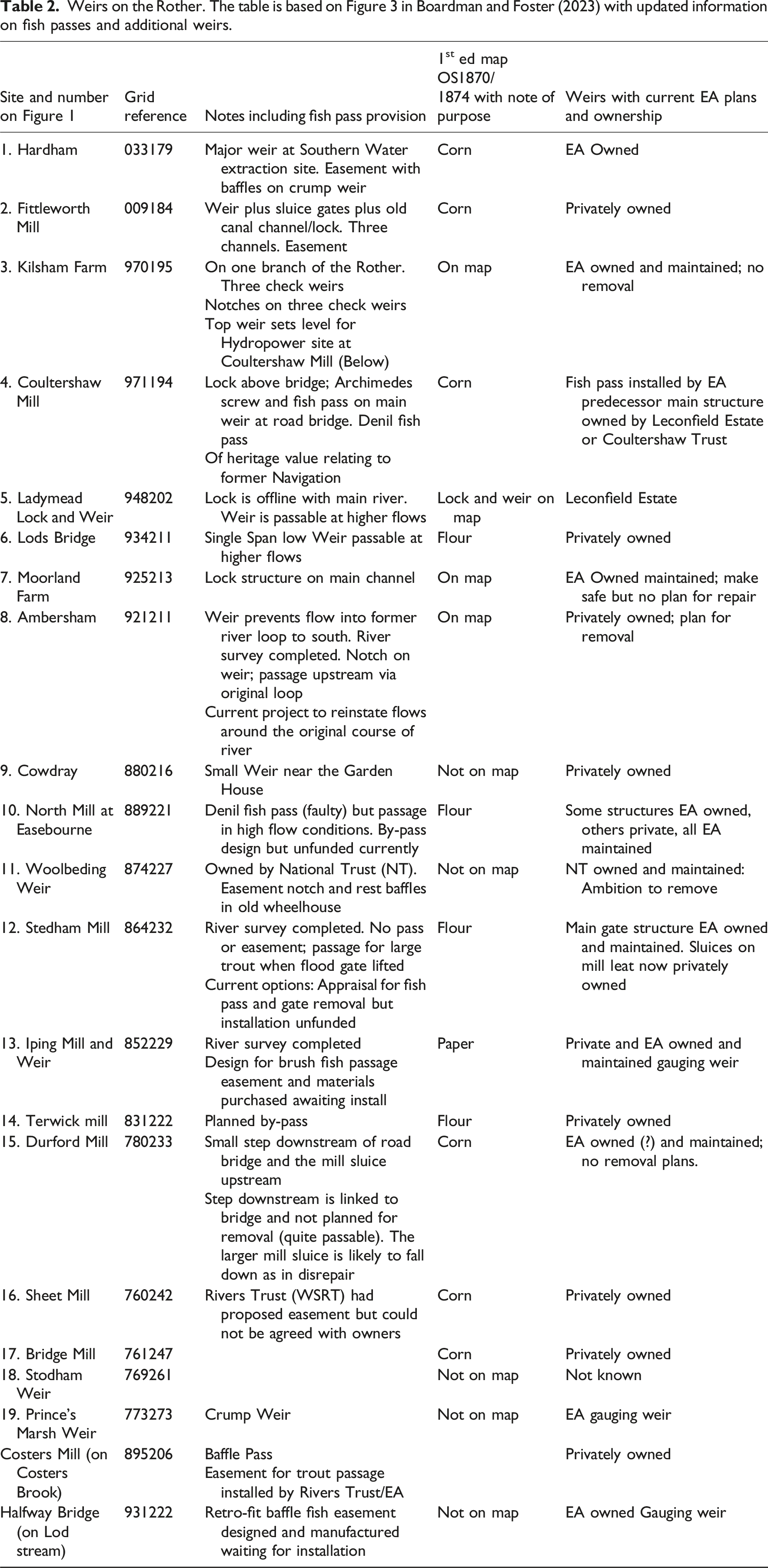
Thousands of small river weirs have been constructed over the last ca. 1000 years or more to provide power for milling and crushing ore, for industrialisation, electricity generation and navigation. Alternative power generation and transportation methods have left many of these structures obsolete and/or derelict. Recently, there has been a drive to create ‘free-flowing’ rivers with fewer or no barriers thereby increasing connectivity and improving ecology. Our first aim was to explore a range of literature and legislation on weir removal in the UK and identify the key benefits and drawbacks in removal that have emerged. We found that ecology was only one of many themes that could be used to justify weir removal or retention. Our second aim was to explore the issues involved with weir removal in a lowland river system in the UK based on the West Sussex Rother where three weirs were being considered for removal. The smothering of ecologically important river gravels by sand trapped behind these weirs and the subsequent release of this sand on removal emerged as a potentially new issue not identified in the literature reviewed. Our third aim was to explore management structures and key stakeholders involved in decision making in the Rother catchment, to establish whether a coordinated approach to delivering weir removal as part of a river management plan could be successfully delivered. We found many official and unofficial organisations have a legal or potentially legitimate interest in the Rother that could produce conflicting evidence for the benefits of weir removal. We conclude that strong leadership and good coordination are required to deliver a successful outcome that requires not only consideration of all the issues involved but which promotes public engagement, and the delivery of an evidence base by monitoring the consequences of any management action.
Introduction
The European Commission have recently launched a major initiative within the Biodiversity Strategy to achieve 25,000 km of ‘free-flowing rivers’ by the year 2030 as part of European wide river restoration (EC, 2022). The UKs National Biodiversity Strategy aligned itself to this goal and recognised the importance for maintenance and enhancement of ecosystem health. This specific initiative requires the removal of artificial river structures as ‘obsolete barriers’ and the restoration of floodplains and wetlands. The strategy does not relate to dams created naturally by fallen trees and branches and other organic accumulations known as debris dams (see Piégay and Gurnell, 1997 for examples); or to dams constructed by ecosystem engineers such as beavers (Castor fiber) (see Brazier et al., 2020 for example). Natural dams are therefore excluded from our discussion.
There is evidence to suggest that there has been an increase in the number of weirs removed in Europe since 2020 and a general increase in the number of European Countries engaged in weir removal (Figure 1). While countries comprising the UK are amalgamated as one country in Figure 1, in 2024, England, Wales and Scotland removed 18, seven and three weirs respectively. Overall, the UK currently lay 5th in 2024 behind Finland (138 weirs removed), France (128) Spain (96) and Sweden (45). Trends in European Weir Removal. *Data for England, Scotland, Wales and Northern Ireland amalgamated as one country.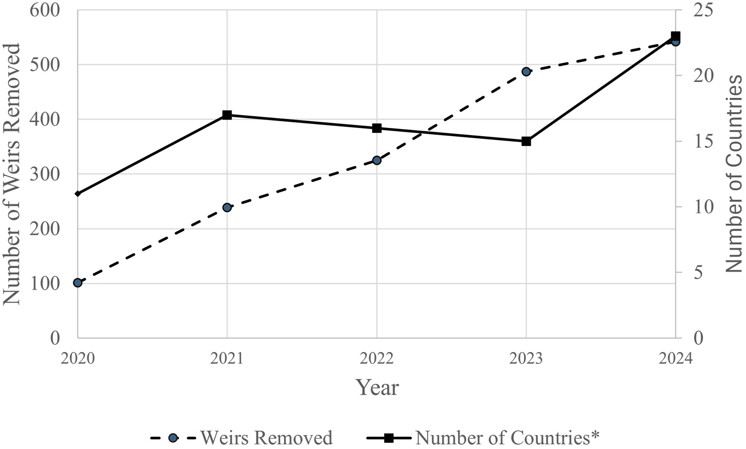
The UK Biodiversity Strategy is an integral part of the EU Water Framework Directive (WFD) and thus the UKs good Water Environment Regulations (WER, 2017) which aims to return rivers to a pre-barrier ‘reference condition’ to achieve ecological and chemical status (Foster and Greenwood, 2016). The WFD remains incorporated into UK law post-Brexit (Defra, 2024). The strategy recognises that some barriers cannot be removed but they may be made less of an impediment to the movement of water, sediment and wildlife by, for example, the installation of fish passes. Thus, the historical fragmentation of Global rivers may be reduced (see classic examples in Petts et al., 1989; Scorpio et al., 2024; Wohl, 2019).
The EC (2022) also stresses the need for data gathering on all barriers and future monitoring of the effectiveness of any mitigation actions. The strategy was built on the earlier work of Grill et al. (2019), who produced a global map of free-flowing rivers, that is, rivers without barriers, and a similar but more detailed mapping of European rivers by Belletti et al. (2020). The latter authors used a combination of modelling and field mapping to estimate a mean frequency of 0.74 barriers per kilometre on European rivers. A very similar figure for England (0.75) is suggested by Jones et al. (2019). Several authors stress the importance of often overlooked small dams and weirs although ‘small’ is variously defined (Belletti et al., 2020; Fencl et al., 2015; Jones et al., 2019). For the purposes of this paper, we refer to weirs as structures built across a river to raise the water level upstream and/or regulate its flow. A dam is a barrier constructed to hold back water and raise its level, forming a reservoir. Dams normally increase the area of the upstream surface water to a value significantly greater than the area of the original river channel.
The EC (2022) argues that the removal of weirs is generally beneficial for several reasons including easier upstream movement of migratory salmonids (e.g. Garcia De Leaniz, 2008), increased habitat diversity and a shift towards more natural habitats (Jones et al., 2022). However, there are also potential negative impacts of weir removal which may result in the mobilisation of sediments stored behind the weirs (including any sediment-associated contaminants) and the easier spread of invasive species (Schiermeier, 2018). The release of stored sediments because of mill dam failure is discussed by Bishop and Munoz-Salinas (2013) and a modelling approach to weir removal on the River Dove, Derbyshire, is used to investigate the hydraulic and geomorphological response of the channel to single and multiple removals (Bulcock, 2021). However, the impacts of weir removal are often organism specific as Robinson et al. (2019) showed that barriers in the River Medway, in the county of Kent, Southern England, restricted the upstream movement of mitten crab (Eriocheir sinensis) but had no effect on the movement of signal crayfish (Pacifastacus leniusculus), probably because they mainly disperse in a downstream direction (Robinson et al., 2019).
In the UK there has been little direct research into the benefits or disadvantages of weir removal, but far more on weir installation within the context of broader river restoration schemes. Exceptions to this are the EA Report SCO70024 (2013) and the work of Downward and Skinner (2005) who discuss the options regarding the management of failing mills and associated weirs using three case studies in different areas of the UK. Downward and Skinner note that the geomorphological and hydroecological impacts of weir removal on rivers is likely to be complex and often site-specific. The map produced by Dam Removal Europe (undated) can be updated on a regular basis by members of the public through an ‘app’ (The Amber barrier tracker) and is available at https://damremoval.eu/. The data are analysed and reported annually (see below). Current maps show that few dams have been removed in the UK compared to the number removed in Finland, France and other European countries. UK examples include two weirs removed on the Hatchford Brook in Birmingham and modifications to weirs at Padiham in East Lancashire. The major (£19 million) scheme ‘Unlocking the Severn Project’ focuses on weir modification, and the introduction of fish passes rather than weir removal (Canals and River Trust, 2018).
Weir removal also raises issues of the advantages and disadvantages of increased lateral and longitudinal connectivity for flood control, and for ecological and sediment management (Fuller and Death, 2018). River restoration schemes often promote the re-connection of river channels to their broader floodplain, often creating new habitats in the form of wetlands. While we aim to explore these issues in relation to a lowland UK river, specific actions on weir removal generally will require local decisions which properly lie within the remit of regulatory and policy-making authorities. Kass et al. (2022) have recently reviewed the complexities of science-policy relationships in such decision making.
The impact of dam removal on ecology has been investigated in other countries; for example, in Michigan and Wisconsin rivers, Hansen and Hayes (2012) suggested that recovery times for macro-invertebrate communities was between 3 and 7 years. These estimates are clearly site-specific and may not transfer to other rivers. However, the delay in response (known as reaction time) is a key geomorphological concept that needs to be communicated to planners to show that delayed recovery following an intervention in, or disturbance to, a natural system is common (Trimble and Lund, 1982).
There are high level/strategic policy drives to remove structures in England and Wales – which involve, for example, promoting natural processes and natural flood management (NFM). The removal of structures owned by the EA flood risk management team is not always about assumed/better flood protection, typically it is financial. Removing or decommissioning structures that have no flood risk benefits when they come to the end of their asset life require no costly maintenance. Many of these structures have been inherited by the EA and put onto the flood risk management asset book. Old structures that have fallen into disrepair may fail without warning and thus planned removal may be the least bad option. Local flooding is sometimes blamed on the non-opening or late opening of weir sluice gates to reduce local water levels. However, it is difficult to assess the validity of these claims and, in many cases, weirs cannot be opened due to a lack of sluice gates.
In the UK, angling often dominates the drive for barrier removal and river restoration over other issues (c.f. Lespez et al., 2015). Structures have been taken out in other UK catchments where no consideration has been given to WFD elements beyond fish (a sub-element of ecological status). In the Lespez et al. (2015) study, the driver for WFD implementation was only fish passage with no consideration given to hydromorphology which is also an important WFD element. The differing priorities in decision making between different WFD elements (e.g. fish/ecology and hydromorphology) often underpins the debate regarding the proposed removal of river weirs. Downward and Skinner (2005) suggest that in general, there are three options relating to any decision not to remove weirs; (i) Do nothing and manage the river if a weir eventually fails; (ii) Manage any weir failure over time and mitigate the impacts if necessary or (iii) Maintain the structure for the long-term. Here, we explore a fourth option based on actively removing weirs and carefully monitoring the consequences.
Our research has explored the physical and cultural background to the Rother and its long history of human impacts through construction of weirs, ponds and an 18th Century navigation (Boardman and Foster, 2024). In this paper we aim to investigate issues of weir removal in a lowland river setting which has been only infrequently investigated in the published literature. Specifically, we aim to Identify, from a review of literature and current recommendations by the UK Government and European Union, the key environmental, social and ecological issues that have been or should be considered before removing weirs. Present a case study of a lowland river based on an examination of weir removal proposals on the West Sussex River Rother to explore whether lowland river weir removal adds further issues to those identified in the literature review. Identify the key stakeholders that have emerged from attempts to develop a future plan for the management of the Rother.
Methods used to address each of the three objectives identified above are discussed in the relevant sections. This paper is developed from issues raised in Boardman and Foster (2023) with more detailed discussion of river data and a full consideration of stakeholder viewpoints on weir removal.
Issues for Weir removal, UK and EU guidance
A summary of advantages and disadvantages of weir removal based on case study reports and references identified at the foot of the table.
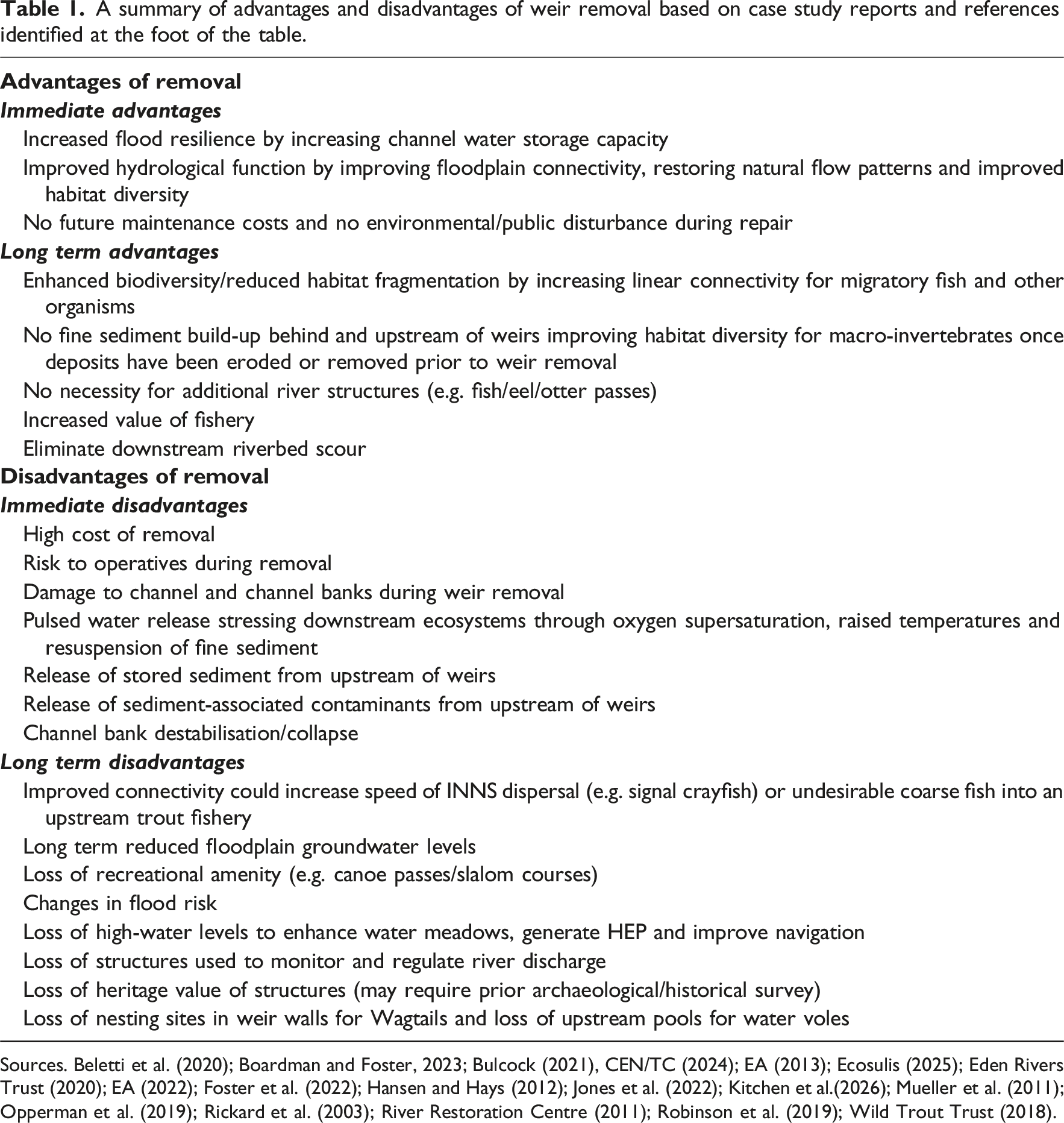
Sources. Beletti et al. (2020); Boardman and Foster, 2023; Bulcock (2021), CEN/TC (2024); EA (2013); Ecosulis (2025); Eden Rivers Trust (2020); EA (2022); Foster et al. (2022); Hansen and Hays (2012); Jones et al. (2022); Kitchen et al.(2026); Mueller et al. (2011); Opperman et al. (2019); Rickard et al. (2003); River Restoration Centre (2011); Robinson et al. (2019); Wild Trout Trust (2018).
A recent international general guide to the impact of removing river structures on sediment dynamics is provided by CEN/TC (2024). The Environment Agency (EA, 2017) also published a report which recommends reference to a document produced by CIRIA (2016) concerning the design, construction, maintenance and removal of river weirs that identifies several key issues that are listed in Table 1. This advice currently replaces guidance provided by the EA (2003). A pdf is available to download from the CIRIA web address given in the reference to CIRIA (2016). Several key issues relating to weir removal are listed beyond those our surveys have focused on in the Rother including the potential aspects of heritage and archaeology. Issues of health and safety potentially affect the removal working crew and there may be implications for water quality with the release of anoxic or contaminated sediments stored upstream of the weir. However, the presence of weirs reduces flow and increases water temperature thereby reducing dissolved oxygen (DO) concentrations upstream so their removal will likely improve DO status. Removal may also affect hydropower generation (currently operating at Coultershaw on the River Rother and providing a green source of energy) and potential loss of flow measurement structures or create a change in the discharge:stage relationship (e.g. the EA river monitoring weirs on the Rother). Loss of recreation and navigation is inevitable with a reduced navigation draught, but removal may also provide increased diversity for angling. A key focus of the guidance is on fisheries and ecology as removal of weirs will likely improve connectivity along main river and could restore riverine habitat and marginal habitat to near natural conditions in the long term. However, changes to species distribution may be perceived as detrimental by anglers and increased connectivity may also provide easy migration routes for alien species along the main river and its tributaries.
Other key issues, including landscape and visual impact, geomorphology (increased stream power, sediment mobilisation, knickpoint recession and bank erosion) should also be considered. Hydraulic factors include reduced upstream water levels potentially affecting local floodplain groundwater levels, change in floodplain inundation frequency (loss of lateral connectivity) and a steeper hydraulic gradient causing potential scour.
A key issue not considered by CIRIA (2016) is the reaction/relaxation time in the system for various components to adjust to the new conditions once weirs have been removed. The first major flood will likely mobilise some but not all stored sediment and change the character of the downstream reach, in the case of the Rother by smothering downstream gravels with inert sand. This raises the question as to whether the upstream river should be dredged prior to weir removal which raises several other significant environmental issues in addition to deciding what to do with the sediment once removed (e.g. does it constitute a controlled waste; see EA, 2016b). In the case of the Rother, we have suggested that the sand is not likely to pose a significant contaminant threat due to the very low silt and clay content where most contaminants would be expected to bind, but it will most likely accumulate upstream of the next downstream weir and smother new areas of river gravels with inert sand which will likely reduce biodiversity and reduce local fish food resources.
Undoubtedly, post-removal monitoring should also be required to establish the extent to which local groundwater lowering may destabilise channel banks. This is especially important on the Rother as the banks have a high sand content, and the Rother is often deeply incised into its floodplain. The high loading from large individual trees along the banks may further destabilise the channel banks. In our experience, post-removal monitoring is not perceived as a high priority to the detriment of improving our understanding of the consequences of weir removal.
The European Commission has recently produced a report on barrier removal for river restoration as part of its Biodiversity Strategy 2030 (EC 2022). The objective is to provide consistent advice to member states of those issues that need to be considered prior to barrier removal and what the implications might be for strategic removal of multiple barriers in relation to longitudinal connectivity.
Garcia De Leaniz et al. (2021) and the EC (2022) have undertaken a detailed evaluation of issues that need to be considered before barrier removal based upon the use of a decision tree. Such a system could be used to identify the priority order in which barriers should be removed. However, since connectivity for fish is often a key driver for barrier removal, consideration also needs to be given to the improvement in whole network connectivity depending on the order in which barriers are removed as illustrated in Figure 2. Example of targeted dam removal (depicted by a star) that seeks to achieve continuous functional river segments (b, d) in cases where the main stem is disconnected from the tributaries due to (a) barriers in tributaries and (c) barriers in main stem (after Garcia De Leaniz et al., 2021).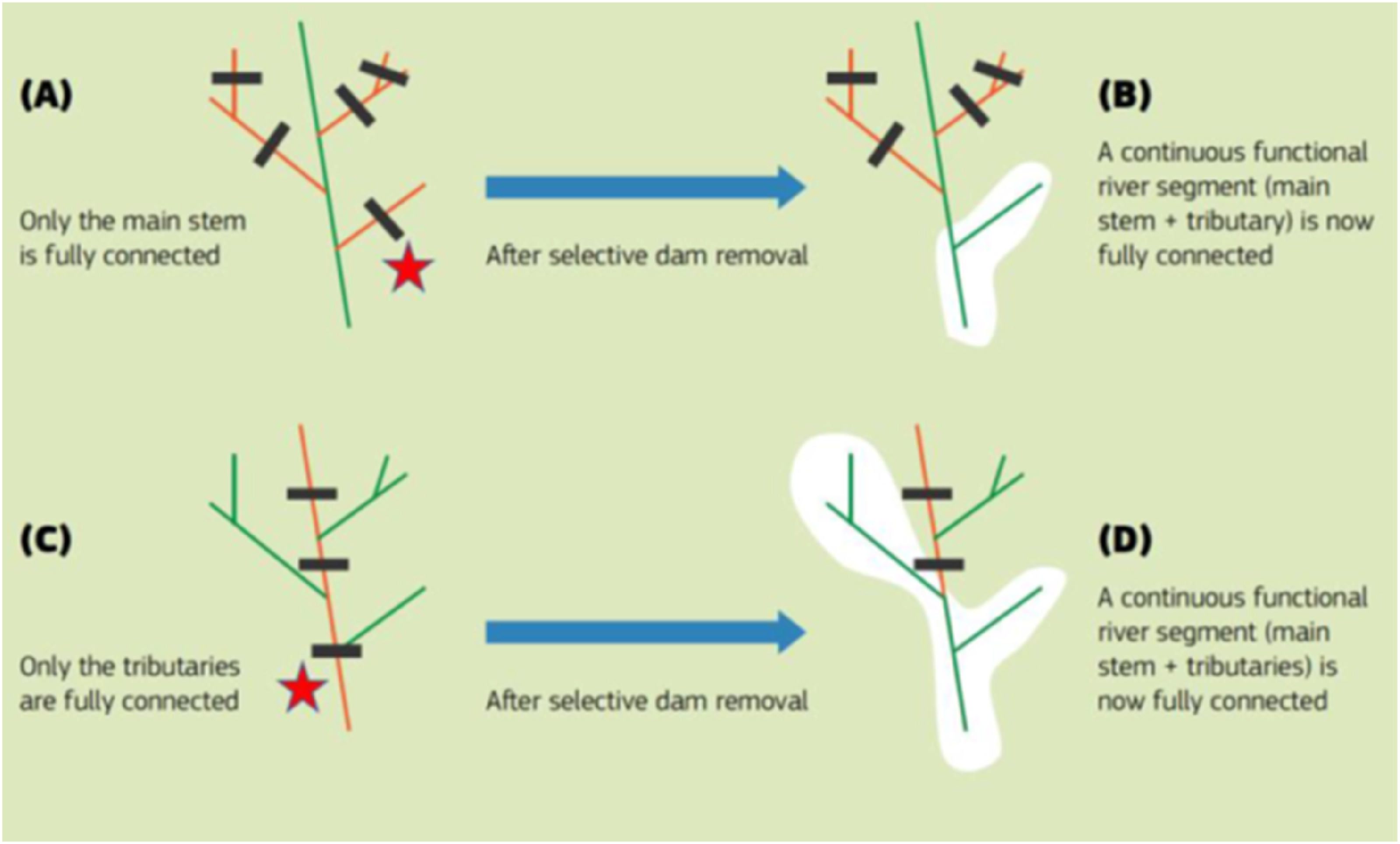
The study catchment: River Rother, West Sussex
The empirical study focuses on a lowland, low energy UK river, the Western Rother, which rises in Hampshire but flows mostly through West Sussex in southern England (Figure 3). It is similar in character to the low energy Seulles river in northern France described by Lespez et al. (2015). Their research emphasised current poor knowledge of the functioning of low energy rivers and the lack of any specific objectives for river restoration, including dam and weir removal. The present detailed study of three weirs was initially prompted by discussions with the local Environment Agency and representatives of the Arun and Rother Rivers Trust (ARRT) (now West Sussex Rivers Trust: WSRT) and the National Trust who were exploring the implications of removing these weirs from the River Rother, including a mediaeval mill weir at Stedham and a mill weir at Woolbeding. The Rother catchment; weirs, locks and key sampling sites © Crown copyright and database rights 2023, Ordnance Survey (100025252). The figure is based on Figure 2 in Boardman and Foster (2023) with updated locations of gauging stations and weirs.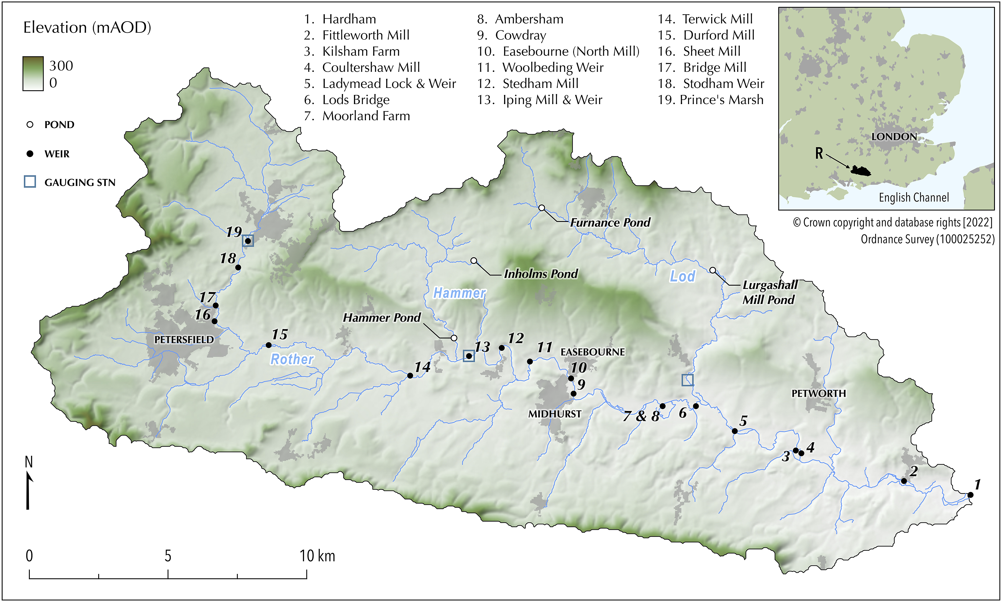
Physical background
The River Rother in West Sussex, UK drains an area of 350 km2 within the South Downs National Park and joins the River Arun 1 km west of Pulborough (Figure 3). A major tributary, the Lod, has a catchment area of 51 km2. Most of the Rother catchment is on sandstones and clays of Lower Cretaceous age. A band of highly erodible sandy and loamy soils on Lower Greensand near to the Rother, but not on the floodplain, is intensively cultivated with cereals, vegetables, maize, asparagus and potatoes. Erosion on these soils is described in Boardman et al. (2009, 2020) and was especially serious in the winters of 2000-01 and 2005-06. A high degree of connectivity between fields and the river results from flow along ditches, roads, sunken lanes and culverts beneath roads (Boardman, 2013; Boardman et al., 2019; Favis-Mortlock et al., 2022). Annual rainfall at Petworth Park is 863 mm (1981-2016) with December (102 mm) and November (100 mm) being the wettest months.
Downstream of the confluence with the River Lod, Mean Daily Flow (MDF) can be estimated by combining data from the Iping Mill gauge on the Rother and the Halfway Bridge gauge on the Lod. Maximum MDF is ca. 73 m3 s-1 (06/11/2000). Under such conditions, some flooding of the floodplain is experienced suggesting occasional connectivity between the river and its floodplain. Maximum MDFs on the Lod, are higher than would be expected, based on comparative catchment areas, with 23 m3 s-1 on the Lod and 55 m3 s-1 on the Rother at Iping. Most of the freshwater network of the Rother catchment is classified as of moderate quality for WDF classification purposes, with the Lod and the Western Rother upstream of Petersfield of poor quality (EA, 2020).
One issue of relevance to the presence of weirs on the Rother is the erodibility of soils that have developed on the Greensand which is found extensively in the catchment. The delivery of eroded sand from these soils to the river channel potentially smother the gravels upstream of weirs. Our literature search reported above identified no academic papers or policy documents that identified smothering of natural river gravels by sand as an issue. However, suspended sediment data for the Rother is limited and so we have little information on the amount of sediment transported. The most recent data is that of Sear (1996) with an annual load of 6470 t estimated at Hardham (site 1 on Figure 3) for 1985-90 which would give a specific sediment yield of ca. 18.5 t km-2 yr-1 for the Rother catchment, a figure which is lower than expected for an agricultural catchment of similar size and with highly erodible soils in lowland England (Pulley and Collins, 2024). Current estimates of background sediment yields based on lake-sediment accumulation rates over the last ca. 100 years for Inholms Pond, a small largely afforested sub-catchment of the Hammer Stream lie between 40 and 70 t km-2 yr-1 (Evans, 2019), and are much higher than background sediment yields of 5-10 t km-2 yr-1 reported for similar sized UK catchments by Foster et al. (2011). While a very small catchment compared to the Rother as a whole, Inholms pond provides the only data for a largely undisturbed catchment within the Rother catchment as a whole and suggests that, unlike many UK catchments, it has very high sediment yields despite the significant forest cover.
High inputs of suspended sediment from the Lod sub-catchment may well be due to bank instability which is a feature of that stream observed by the authors during walkover surveys. The Lod is also deeply incised through its floodplain to depths >3 m with banks generally comprising significant amounts of sand. Two breaches of the Lurgashall Mill Pond dam in 1967 and 2013 likely released significant flood waves which could also have contributed to bank instability and led to excessive sediment inputs into the Lod and Rother (ARRT, 2021; Evans, 2019; Foster et al., 2024). Bank instability appears to be more a feature of the Lod than of the trunk stream of the Rother, although sediment source modelling based on samples collected bi-monthly in integrated tube samplers at 10 locations in the Rother and its main tributaries between 2015 and 2016 suggested that channel banks contributed c. 50% of the sediment transported over that time at all sites (Evans, 2019). Evidence for increased bank contributions to sediment yields since the mid-1950s is apparent for the sediments accumulating in Furnace Pond and Lurgashall Mill pond on the River Lod and in samples collected from the Lod immediately upstream of its confluence with the Rother between 2014 and 2016 (Foster et al., 2024).
The likely high sediment transport rates and frequent overbank flooding documented locally likely gives the Rother the highest floodplain sediment accumulation rates in the UK that have been reconstructed using data from fallout radionuclides (Walling and He, 1998).
Human impacts and structures
Weirs on the Rother. The table is based on Figure 3 in Boardman and Foster (2023) with updated information on fish passes and additional weirs.
Potable water is extracted upstream of Hardham weir at a Water Treatment Plant owned by the local water company, Southern Water (SW) (site 1, Figure 3). This weir at the confluence with the River Arun prevents the ingress of salt water into the Rother as, under natural conditions, it would be tidal upstream of this point. SW therefore have an interest in minimising treatment costs due to the presence of pollutants including nitrates, phosphates, pesticides, metaldehyde and sediments. These are removed or reduced to levels below statutory drinking water threshold values with costs estimated at £300,000 yr-1 (Boardman, 2021). There are also costs associated with sediment removal at Hardham, with options including disposal to agricultural land. SW are tasked with addressing issues of diffuse pollution impacting raw water quality through legal instruments from the Drinking Water Inspectorate (DWI notices) and thus have an interest in reducing contaminant concentrations in the water and understanding, and controlling, their origin. In the Rother catchment, SW are incentivising farmers to go ‘metaldehyde free’, working in partnership with Natural England to fund a local ‘Catchment Sensitive Farming Officer’ and running a pilot as part of the Interreg ‘Channel Payments for Ecosystem Services’ (CPES) (Southern Water, 2019).
Other restoration projects have been undertaken in the Rother catchment. A gravel riffle has been installed at Shopham, immediately east of site 4 on Figure 3, and meanders have been restored at Shopham (the Shopham Loop project) which had wider aims (i.e. other than fish passage) to create a better habitat for fish, invertebrates and macrophytes (Cox 2017; EA, 2015). It also had hydromorphological benefits although it was undertaken before full WFD implementation. Partial removal of a weir in 2024 at Ambersham (Figure 3, site 8, Table 2), for example, has provided an opportunity to reverse some of the effects of the Rother navigation which reduced river length by ca. 1 km to shorten the distance from the confluence of the Rother at Hardham with the River Arun, to Midhurst. A full assessment of this action, however, appears not to have been undertaken
A history of sediment problems
The issue of sediment accumulation in the Rother and its impact on fish and invertebrates was raised by Sear (1996) and extensively reviewed in a Fisheries Action Plan (EA, 2001). The Fisheries Action Plan stresses the need to collect data on sediment in the river and to work with the farming community to alleviate the problem. The issue is contentious because the condition of the river in the past can be used as a ‘reference condition’ against which present and future changes associated with weir removal can be evaluated. However, much of the evidence on past condition is anecdotal and comes from the angling community. Ad hoc interviews with local property owners and anglers have suggested that several reaches of the Rother are highly dynamic and water depths have varied substantially over the last ca. 20 years or more as a result of alternate sedimentation (particularly sand) and subsequent scour.
Key stakeholders in Rother management
Key stakeholders with interests in the management of the Rother have been identified during more than a decade’s research by the authors in the catchment, from workshops and meetings held at the South Downs National Park headquarters in Midhurst and as a recent book was produced highlighting general future management issues in the Rother (Boardman and Foster, 2024). The following summarises the stakeholders and explores their present and future role in the management of the Rother.
Stakeholders with an interest in the River Rother (based on Foster and Boardman, 2024).
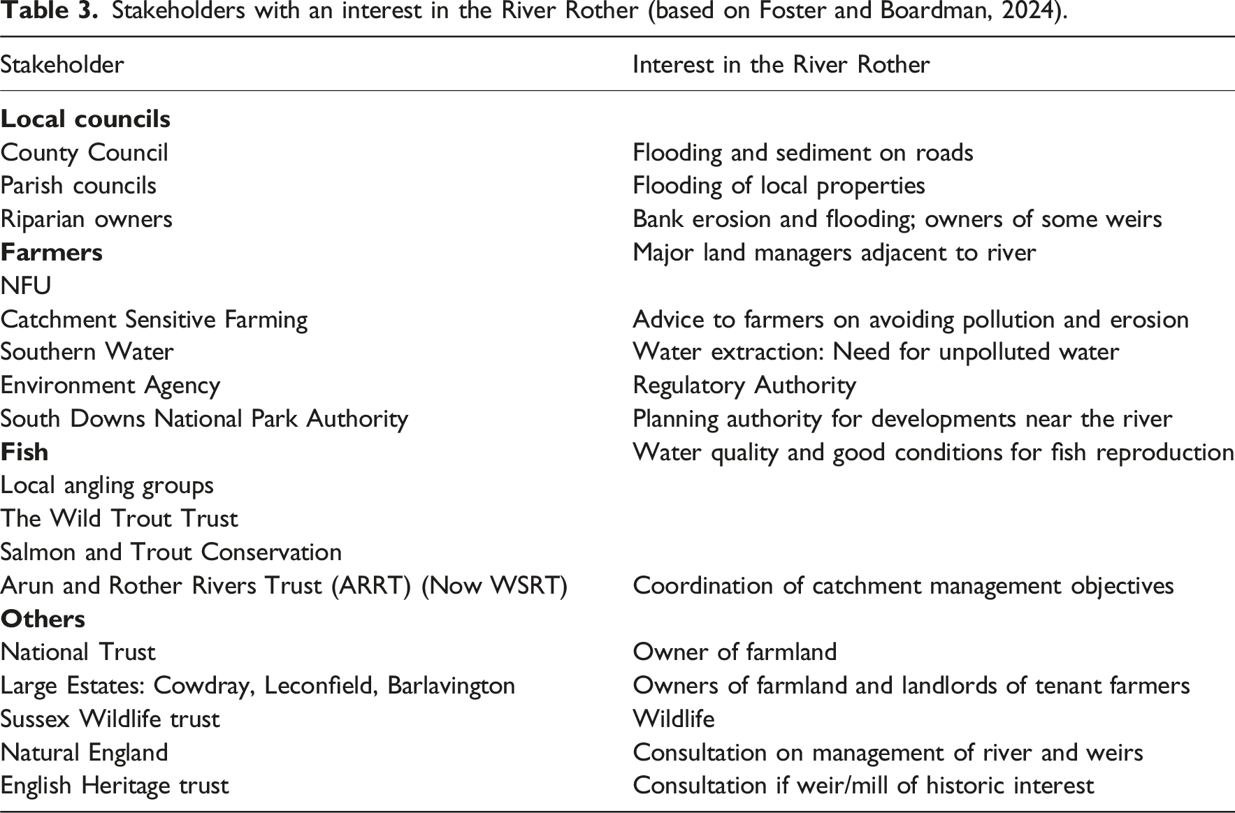
None of the weirs on the Rother are classified under listed English National Heritage Status, either at Grade I or Grade II, although some associated mill houses and mediaeval bridges on the Rother are classified as Grade II. There are therefore no heritage reasons why weirs cannot be removed (Historic England, 2023). However, ownership is variable and includes the UK Environment Agency, the English National Trust and several private owners (Table 2). Removal and or installation of structures on a main river are covered under regulations governing the assessment for a flood risk activity (EA, 2016a). The regulations provide guidance on how to assess the impact of a flood risk activity and decide whether it supports the objectives of the local River Basin Management Plan or supports sustainability criteria. The guidance covers 13 separate activities of which three may be relevant to weir removal: impounding structure, sediment removal and bank reprofiling. It suggests that the assessment should be proportionate and not entail excessive economic cost but the main criteria along with flooding is compliance with the European Water Framework Directive (WFD). Unfortunately, none of the 11 water bodies in the Rother catchment meet a Good Ecological Status classification under WFD largely because of poor chemical quality arising from farming and sewage effluent discharge (EA, 2022; Southern Water, 2022). Increased connectivity for fish passage appears to be a key driver of weir removal on the Rother and several weirs already have fish passes constructed. This may be a cheaper and more parsimonious solution to improving connectivity than weir removal although the effectiveness of the various types of fish passes and ‘easements’ (Table 2), is open to debate (Andy Thomas, personal communication).
Field surveys of the Weirs
In response to the EA’s proposals for weir removal, detailed surveys of sediment storage have been carried out at three weirs, Stedham, Iping and Ambersham. We report here the methods and results of the survey at Stedham and summarise the key findings at the other locations to identify the potential benefits and threats to the Rother as a whole if they were removed.
Field surveys
Sediment samples were recovered at approximately 75 m intervals over a ca. 1 km stretch of river upstream of Stedham Weir which was surveyed and sampled in September and October 2020 (Figure 4). Methods of sampling are described in detail in Foster et al. (2022). In brief, water depth was measured from a boat using a secchi disk at three equidistant points across the channel at 14 cross section locations (Figure 4) where sand had accumulated above the natural gravel riverbed. A sharp pointed survey pole was used to probe sediment depth to the point where the probe would not penetrate deeper (assumed to approximate the sand thickness overlying the original riverbed). Average river width was measured at 14 m and 52 sand thickness measurements produced a mean of ca. 0.45 m with a standard deviation of ca. 0.23 m. This provides an estimate of 6350 +/−3200 m3 of sediment stored upstream of the weir. Using densities measured on ∼ca. 5 cm diameter cores taken upstream of Ambersham weir (ca.1.65 g cm-3), this equates to a sediment mass of 10,477 +/−6875 t. Eckman surface grab samples were collected at approximately the mid-point of the river at the 14 locations. Samples returned to the laboratory were oven dried and dry sieved to determine the particle size distribution of the material recovered between <125 µm and <8 mm at 1 phi intervals. Further information on sediment storage behind the weirs is provided in Foster et al. (2019) and Boardman and Foster (2023). Sediment sampling points on the River Rother above Stedham Weir.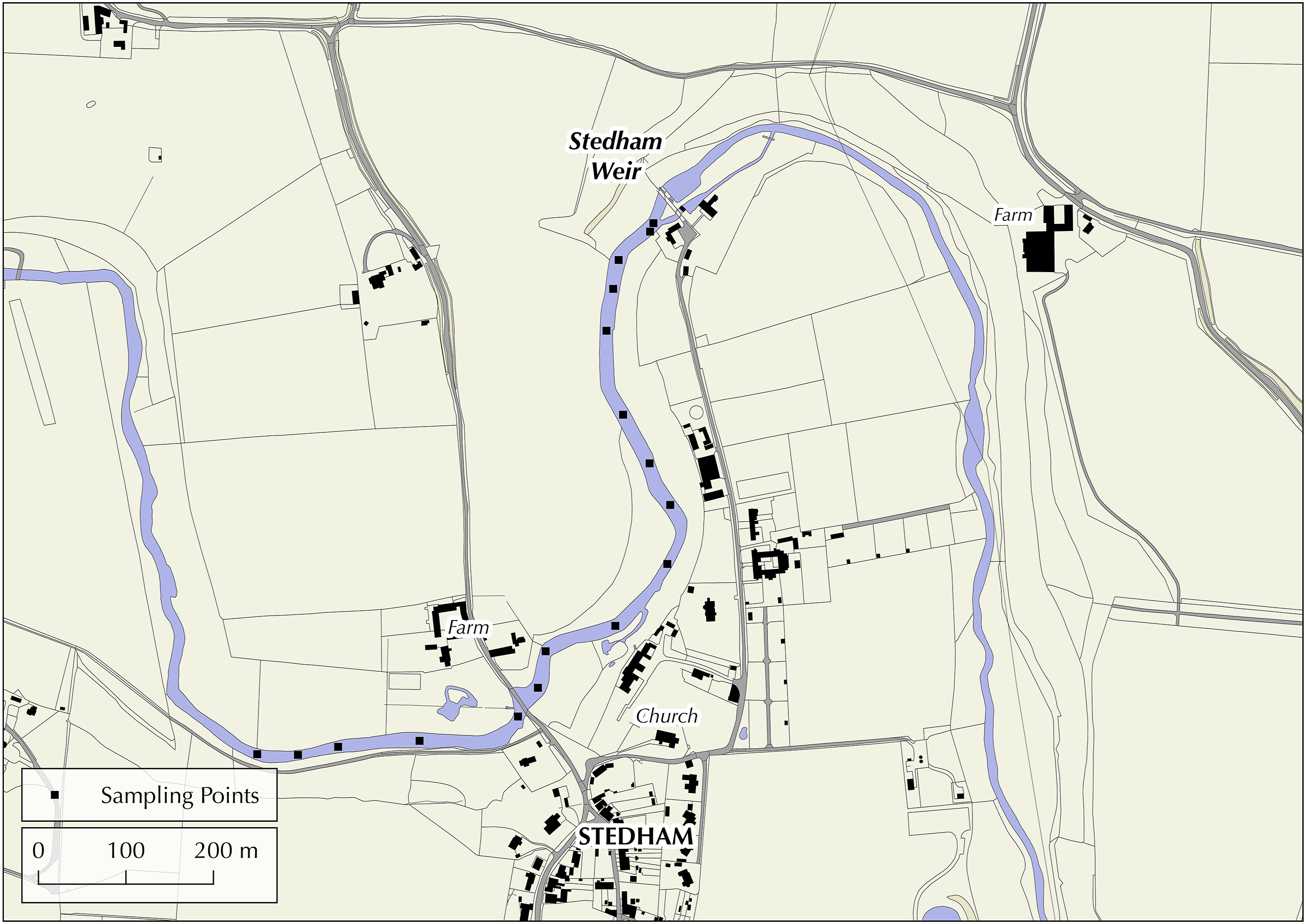
The <125 µm fraction was consistently less than 4 % of the total sample mass and most sediment lay in the particle size range between 250 µm and 1 mm diameter (i.e. medium to coarse sand). Particle size analysis of bed sediment recovered in the same way from the River Lod showed almost 18 % of the sediment by mass was below 125-micron diameter. Loss on ignition on all 14 samples produced a mean of 1.4 % with a standard deviation of 0.84 %.
Our analysis in the Rother suggests that the <125 µm fraction in surface sediments sampled with the Eckman grab has not been stored for much more than a year (Foster et al., 2019).
A similar sampling procedure at the Ambersham and Iping Weirs gave an estimate of ca. 12,500 t and 4000 t of sediment stored immediately (within ca. 1 km) upstream of the respective weirs.
Implications of extensive sand accumulation and potential Weir removal
Unlike reports on weir removal from upland gravel-bed rivers, the accumulation of sand upstream of weirs in this lowland catchment significantly reduces water storage capacity and provides a substrate largely unsuitable for macro-invertebrate colonisation (Descloux et al., 2013; Mathers et al., 2017; Vadher et al., 2015). This also impacts on flood risk in that water storage capacity above weirs is reduced by sand accumulation. In exploring sediment sources in the Rother, Sear (1996) found little evidence for excessive bank erosion and noted significant changes in land use from grazing to cultivation. Increases in arable land have led to far more cultivated fields potentially connected to the river (Boardman et al., 2020; Favis-Mortlock et al., 2022). Recent work by Evans (2019), however, suggests significant inputs of sediment from bank erosion on both the Lod and the Rother.
Major unknowns have arisen following the current survey. With an increase in gradient after weir removal, even relatively small flood flows will begin to remobilise stored sand. However, without detailed cross sectional and long profile surveys of the downstream reach, it is not possible to model the rate at which sand would be removed or its eventual point of redeposition upstream of the next downstream weir. As the sediment mostly comprises sand, there is little likelihood that it will be carrying quantities of sediment-associated contaminants as these are normally found in the silt and clay fraction of fine sediment (e.g. Foster and Charlesworth, 1996). If the release of sand downstream causes additional smothering of spawning gravels, it may be necessary to consider sand removal before weir decommissioning. However, this may be costly in terms of dredging and disposal. The low structural stability, low organic matter content and high sand content would suggest re-spreading the dredged sand on agricultural land would not be a credible option. The issue of sand release appears also to have been ignored in the published literature. It may be that the problem is acute on the Rother because of the erodibility of the soils and channel banks, the presence of large amounts of sand, and the high degree of connectivity between arable fields, channel banks and the river.
The sediment building up behind the weir at Stedham is predominantly between 125 µm and 1 mm diameter (fine sand and coarser) and is a problem in that it smothers the gravels that underlie the sand. The environment created by up to 70 cm of sand makes fish spawning unviable, provides a poor habitat for most organisms that would normally occupy the fluvial substrate and minimises the variability in patch structure created by particle sizes over a much wider range of diameters (clay to cobbles). Finer material (<125 µm), which comprises <4% of the bed sediment, is more likely to travel in suspension and to carry pollutants and is therefore the primary concern at the water treatment plant. However, sand can be transported in suspension at very high discharges as testified by the presence of fresh sand splays on the Rother floodplain after overbank events. At Stedham, the potential removal of the weir for fish passage may have negative implications for downstream hydromorphology due to the remobilisation of stored sand and in addition the potential for ‘free movement’ of invasive species such as signal crayfish (c.f., Fuller and Death, 2018).
Weir removal will lead to lowering of water levels in the channel upstream of the weir and would be exacerbated by any removal of stored sand. The main danger with water level lowering is for bank instability to occur; the magnitude of which will depend on the morphology of the ‘new’ channel and subsequent river discharges. It will also likely lower the local groundwater table in the floodplain adjacent to the river.
Weir removal on the Rivers Teme, Lugg, Clun and Rea in the West Midlands released large volumes of coarse sediment (mainly gravel and cobbles) downstream but this was less of a problem compared to subsequent bank erosion and regrading of the channel (EA, personal communication, 2022). However, these rivers have little sand, are dominated by gravel beds and are of much higher energy than the Rother due to their much steeper gradients.
In a detailed study of the impact of water-powered mills on mid-Atlantic, USA, streams, Walter and Merritts (2008) show that the construction of mills created a series of slack water ponds; sedimentation then converted the ponds into sediment-filled reservoirs. Subsequent dam breaching led to channel incision and accelerated bank erosion. Aspects of this model could be applicable to the Rother and Lod.
Discussion
The removal of weirs intersects with discussions about restoration of the river and its floodplain. The issues could, however, be treated quite separately. Weirs could be removed without engaging in discussions about the ‘rewilding’ of the floodplain.
However, the WFD hydromorphology element definition should make this explicit. Hydromorphology has three components – hydrological or tidal regime, river continuity conditions (lateral and longitudinal), and morphological conditions (depth and width variation, structure and substrate of bed, and structure of the riparian zone). Hydromorphology is only used to determine high status classifications under WFD. Therefore, focus will inherently be on the ‘elements’ that determine the other ecological status classes (i.e. good, moderate, poor or bad). These elements are biology (fish, invertebrates or algae), physico-chemistry (e.g. oxygen, phosphorous, ammonia) and ‘specific pollutants’ (e.g. zinc and arsenic) (WFD, 2015).
It seems unlikely that weir removal would be undertaken without some concept of ecological restoration, at least of the river channel. The restoration of meanders and creation of a gravel riffle in the Rother catchment described earlier had wider aims (i.e. other than fish passage) to create a better habitat for fish, invertebrates and macrophytes (EA, 2015). It also had hydromorphological benefits although it was undertaken before WFD implementation.
If we are trying to restore a degraded river system in a predominantly lowland arable agricultural landscape, it seems unlikely that we can do more than stabilise the banks of the single channel meandering river and return some (all?) of the floodplain to grassland/hay meadows/woodland with the help of owner participation and grants such as those from Countryside Stewardship or the Forestry Commission woodland grant scheme. Such a rewilding could complement efforts to restore connectivity between the river channel and the Rother floodplain (Collins, 2024). Arguments in favour of restoration of floodplain meadows in the Rother valley were put forward by Pearson and Soar (2018). These include establishing improved connectivity between the river channel and the floodplain as part of a river restoration scheme with opportunities for wet meadows, rewilding, floodplain woodlands, wetlands etc, with benefits both for ecology and flood risk management.
Fortunately, there is very little cultivated land on the floodplain of the Rother. The associated challenge is to decrease connectivity between distant fields and the river channel since many of these routeways (ditches, tracks, roads, drains) cross the floodplain (see Favis-Mortlock et al., 2022). Conservation measures on valley side fields could support such an objective (Boardman and Favis-Mortlock, 2024). If the aim is better ecological quality of the river, then this is a crucial objective. However, a number of important questions remain unanswered. Is remobilisation and deposition of the sediment beyond the natural variability for the river? Is the storage temporary, that is, beyond a 5-year WFD/river basin management plan cycle? Is there a potential risk to a sensitive receptor downstream? What is less certain (but could be modelled) is, under what hydrological conditions would significant release of sediment occur, where would it go and what impacts would it have?
The figures provided by science all have associated errors and uncertainties and aim to supply ‘reasonable answers’ and rule out ‘unreasonable’ assertions. But they cannot define policy, and we also must be aware that policy is not always driven by scientific evidence (Kass et al., 2022).
We cannot argue that conflicts can be resolved by science-led inputs (they can only be ‘informed’). It may be that decisions have to be resolved by political expediency. For example, the risk of increased flooding resulting from removal of weirs may be offset by increases in ecological health of the river. And it may be that decisions are taken based on resources available. But the public deserve to know the basis for such decisions.
Conclusion
Reasons for removing weirs need to be carefully considered before any action is taken but most importantly, ownership issues and issues of protected/heritage status need to be explored before any scientific analysis of the benefits or disbenefits of removal is commissioned or undertaken. In the UK, there is a requirement to consider both flooding issues and WFD compliance, but the exact nature of the evidence required will depend on local factors and conditions including the size and construction materials of the structure, safety considerations during removal, potential downstream consequences of the release of any stored sediment and the length of time over which adjustments could take to achieve a new equilibrium state. In addition, consideration needs to be given to negative (e.g. bank instability) as well as positive (e.g. improved connectivity) consequences of removal summarised in Table 1. The number of organisations, interest groups and landowners with an interest in rivers is likely to be high as evidenced by the number of organisations listed in Table 3 and views on weir removal will not be driven solely by the scientific evidence provided. While science can have a role to play in providing robust evidence of potential benefits or consequences, the science might be trumped by heritage or aesthetics as reasons for not removing weirs.
We have generally focussed our discussion of issues around the removal of an individual weir, but such schemes also need to be considered in the wider context of river and landscape restoration and rewilding. While a River Basin Management plan exists for the Rother, its main purpose appears to be compliance with WFD and flood management rather than providing a framework that takes a basin wide approach to river restoration that includes weir removal as part of a much broader remit. The present structure and funding of the Environment Agency and Trusts like WSRT will be unlikely to provide the overview and vision needed to deliver a bold strategy of the type needed in the UK to improve and sustain our rivers in good physical, chemical and ecological health.
Should any of the weir removal proposals be instigated in the Rother, we would strongly urge the competent authority to undertake or commission pre- and post-removal surveys and modelling to provide more detailed guidance than is currently available on the implications of such a strategy.
Footnotes
Funding
The authors received no financial support for the research, authorship, and/or publication of this article.
Declaration of conflicting interests
The authors declared no potential conflicts of interest with respect to the research, authorship, and/or publication of this article.
Data Availability Statement
The data that support the findings of this study are available from the authors upon reasonable request.