
Abstract
Recent developments in tree-ring research offer great potential for reconstructing past climate changes; determining the frequencies of natural hazards; and assessing the availability of freshwater resources over timescales that extend well into the pre-instrumental period. Here, we review the state of dendrochronological research in the Himalaya and outline future directions for tree-ring-based hydrological reconstructions in a region that has a pressing societal need to understand the causes and consequences of past, present and future changes in the hydrological cycle. We used ‘tree ring’ and ‘Himalaya’ as keywords to identify scholarly articles from the Web of Science that were published between 1994 and 2022. The resulting 173 publications were separated by their spatial coverage into the western, central and eastern Himalaya, as well as their scientific purpose (e.g. reconstructing growth-climate relationships, temperature, precipitation, streamflow, floods, droughts, etc.). Our analysis shows that dendrochronological research in the Himalaya primarily focused on understanding growth-climate relationships using annual tree-ring widths measurements obtained for coniferous species, and their application in climate reconstructions. Reconstructions of hydrological processes such as streamflows, and extremes such as glacial and landslide lake outburst floods, have received less attention. Recent advances in dendrochronology, including blue intensity (BI), quantitative wood anatomy (QWA), and tree-ring stable isotopes (TRSI) should be combined to improve the resolution and accuracy of hydrological reconstructions in all parts of the Himalaya. Such studies may allow us to better understand the effects of climate change and the Himalayan water resources for its lowland surroundings. They may also facilitate decision-making processes for mitigating the impacts of climate change on natural hazards, and for better managing water resources in the region.
Keywords
Himalayan hydrology
Mountains are sometimes referred to as ‘water towers’ (Viviroli et al., 2007) in terms of water resources, because they locally enhance precipitation but also transfer runoff from winter storage to summer runoff; or from ice accumulation in colder years to ice melt in warmer years. The mountain cryosphere can hence be an important source of freshwater resources for millions of people living in both mountains and the adjacent low-lying floodplains. Glaciers and seasonal snow cover contribute freshwater to 1.4 billion people in the Himalayan river basins of the Indus, Ganges, Brahmaputra, Yangtze and Yellow Rivers (Immerzeel et al., 2010). The Himalayan water towers are highly vulnerable to climate warming due to a rapid acceleration in glacier melt (Immerzeel et al., 2020), a situation that will continue for many decades (Wijngaard et al., 2018) albeit to an extent that is still unclear (Immerzeel et al., 2010; Kääb et al., 2012). The rapid recession of glaciers and increase in ice melt due to climate warming leads to a temporary increase in runoff that is known as a ‘glacial subsidy’ (Collins, 2008). Over time, such increases in runoff will slow down and eventually reverse as glaciers become smaller (Chandel and Ghosh, 2021). Whilst such ice losses may be compensated to some extent by increasing precipitation in the future (Chandel and Ghosh, 2021; Immerzeel et al., 2013; Khadka et al., 2020; Singh et al., 2019b), ice loss is likely to be a dominant signal in future changes in runoff (Lutz et al., 2014) and a challenge for managing water resources (Immerzeel et al., 2012; Kehrwald et al., 2008; Maurer et al., 2019) in the Himalaya. By comparison to western and central Himalaya, few studies have addressed glacier recession and its hydrological implications in the eastern Himalaya despite known hydrological differences; whilst snow and glacier melt are particularly important contributions to runoff for western Himalayan rivers, rainfall (mostly monsoon rainfall) is more important for rivers in the eastern Himalaya (Lutz and Immerzeel, 2013).
Besides water resources, natural hazards related to glacier retreat are also a concern. In some regions of the Himalaya, the rapid recession of glaciers due to climate warming is leading to the formation of numerous glacial lakes. These glacial lakes can be hazardous to communities and infrastructure because of their potential to breach catastrophically and to cause Glacial Lake Outburst Floods (Islam and Patel, 2021; Quincey et al., 2007), triggering a sudden release of water and sediment (Khanal et al., 2015). As with the question of water resources, glacial lake formation under changing climate is better understood in some regions than others.
Despite the importance of Himalayan hydrological processes, such as snow and glacier melt to both water resources (e.g. streamflow) and hazards (e.g. floods) there are relatively few hydrological studies available for the Himalaya (Chalise et al., 2003; Chandel and Ghosh, 2021; Immerzeel et al., 2012; Irvine-Fynn et al., 2017; Kirkham et al., 2019; Li et al., 2017; Qazi et al., 2019; Ragettli et al., 2015; Singh et al., 2016, 2020; Thayyen and Gergan, 2010; Viviroli et al., 2007), especially those that extend back to before the instrumental measurement period. Long-term (e.g. centennial to millennial) reconstructions of hydrology, including streamflow and floods in the ungauged or poorly gauged Himalayan rivers, are critical for developing a sound understanding of the impacts that changes in climate may have on hydrological conditions at the basin scale. Systematic and widespread measurements of river flow only really begin in the 1950s and such records are most common for the river plains downstream. One alternative is to use the hydrological records contained in tree rings to extend records back in time. Trees are ‘natural data loggers’ that may record valuable hydrological information in their annual rings from before the start of instrumental records. Thus, the aim of this paper is to review how the analysis of tree rings may assist both long-term climate and hydrological reconstructions in the Himalaya in ways that can inform both water resource management and hazard mitigation.
Himalayan dendrochronology
Dendrochronology is a well-established science initially proposed by Andrew Ellicott Douglass at the beginnings of the 20th century and that provides estimates of both the annual growth of woody plants and other environmentally relevant information through the analysis of physical or chemical properties of tree-ring wood (Bannister, 1963; Coulthard and Smith, 2013; Fritts, 1976; Fritts et al., 1965; Shroder, 1976; Smith and Lewis, 2006). Tree-ring methods have been applied across many different disciplines, including archaeology, for example, dendroprovenancing (Cherubini, 2021; Cherubini et al., 2022; Domínguez-Delmás, 2020; Wilson et al., 2017), environmental reconstructions including hydroclimatic parameters, such as temperature (Aryal et al., 2020) and precipitation (Tejedor et al., 2020), streamflow (Akkemik et al., 2008), floods (Speer et al., 2019), droughts (He et al., 2018) and events such as snow avalanches (Laxton and Smith, 2009; Luckman, 2010; Yadav and Bhutiyani, 2013), landslides (Chalupová et al., 2020), forest fires (Brown et al., 2020), air pollution episodes (Ballikaya et al., 2022; McLaughlin et al., 2002), insect outbreaks (Büntgen et al., 2009) and fungal attacks (Cherubini et al., 2002, 2021). Tree-ring based environmental reconstructions have two major advantages. First, they provide high-resolution (e.g. annual to intra-annual) proxy information over longer time-scales (e.g. centuries or millennia) than the conventional instrumental records. Second, the distribution of trees is almost global, meaning that tree-ring reconstructions are possible over very large spatial and temporal scales throughout terrestrial ecosystems (Bridge, 2005).
In the Himalaya, tree-ring studies began in the late 1980s with the assessment of the potential of different tree species for environmental reconstruction (Bhattacharyya et al., 1988; Ramesh et al., 1985). Despite the occurrence of a wide variety of taxa suited to dendrochronology (e.g. Larix griffithiana, Tsuga dumosa, Abies densa, Juniperus indica, Pinus wallichiana), only a few have been used for the reconstruction of temperature (Aryal et al., 2020; Bhattacharyya and Chaudhary, 2003; Borgaonkar et al., 2018; Chaudhary and Bhattacharyya, 2000; Chaudhary et al., 1999; Gaire et al., 2023; Khandu et al., 2022; Krusic et al., 2015; Yadava et al., 2015) and precipitation (Khan et al., 2020; Sano et al., 2013; Shah, 2018; Singh et al., 2021; Yadav, 2011; Yadav et al., 2014) across the Himalaya (Figure 1). The same is the case for hydrological reconstructions such as streamflow (Cook et al., 2013; Gaire et al., 2022; Misra et al., 2015; Rao et al., 2020; Shah et al., 2013, 2014; Singh and Yadav, 2013). Figure 1 also shows that most tree-ring studies are available in the western and central Himalaya, whereas the eastern Himalaya has received less attention. However, it is important to clarify that this figure was prepared based on tree-ring records available in the International Tree-Ring Data Bank (ITRDB) and it seems that the ITRDB records do not appear to be complete. A number of dendrochronological studies do not appear therein (e.g. Borgaonkar et al., 2018; Chaudhary et al., 1999; Shah et al., 2013, 2014; Shekhar and Bhattacharyya, 2015; Yadava et al., 2015). Tree-ring studies in the Himalaya that are available in the ITRDB (Data source: NOAA), with the upper inset showing the global distribution of tree-ring sampling sites.
Since the start of dendrochronological studies in the late 1980s, an initial focus has been on understanding growth-climate relationships and reconstruction of paleoclimates (e.g. temperature and precipitation), both using conventional tree-ring width measurements (Bhattacharyya et al., 1988, 1992; Bhattacharyya and Yadav, 1999; Hughes, 1992; Yadav, 1992). Palaeohydrological studies using tree-rings have received less attention (Figure 2). Recent advances in dendrochronology, including the analysis of earlywood (EW) and latewood (LW) widths from digital images, blue intensity (BI), quantitative wood anatomy (QWA) and tree-ring stable isotopes (TRSI) have yet to be applied widely across the Himalaya (Bhattacharyya and Shah, 2009; Li et al., 2021; Pandey et al., 2018; Singh et al., 2016). Multi-dimensional applications of dendrochronology in the Himalaya (Data source: web of science; keywords used: tree ring, Himalaya).
Growth characteristics of Himalayan tree rings
The primary focus of tree-ring research in the Himalaya has been understanding growth-climate relationships and reconstructions of past climate, mostly in the western and central parts (Figure 1). Different tree species respond differently to different climatic and topographic conditions and, as a result, the main growth period of any one tree species varies between species (Borgaonkar et al., 2011; Dolezal et al., 2016; Krusic et al., 2015; Schwab et al., 2018; Torbenson et al., 2016). Such variability in growth period between species means that the elements of annual climate that are recorded may vary between trees. In general, the growth period for Himalayan trees is found within the window March to September (Singh et al., 2009). For Himalayan larch (L. griffithiana), the favourable growing season is from May to July (Chaudhary and Bhattacharyya, 2000), during the period of increasing temperature towards the peak of the summer (Aryal et al., 2020). Spring (March to May) is the suitable period for Himalayan hemlock (T. dumosa) (Aryal et al., 2020); winter (December to February) for sal (Shorea robusta) in the Central Himalaya (Baral et al., 2019), and autumn and winter (October to February) for toon (Cedrela toona) in the eastern Himalaya (Shah and Mehrotra, 2017). Tree growth in the Western and Central Himalaya is limited by precipitation between March and May, whereas in the eastern Himalaya it is the air temperature that mainly controls tree growth (Figure 3(a)–(c)). This is probably due to the effect of the Indian Summer Monsoon (ISM) from June to September and sufficient moisture availability (Borgaonkar et al., 2018). The availability of moisture acts as a limiting factor for tree growth at higher tree lines, as has been shown across the Hindu Kush Himalayan regions (Liang et al., 2014; Schwab et al., 2018; Zheng et al., 2021). Growth reduces with the reduction in moisture content of the air and in the soil, as well as with the availability of surface and groundwater during the onset of the growing season (Ahmad et al., 2020; Yadav et al., 2004). Studies have suggested that the moisture deficit not only limits tree growth but also often produces locally absent rings (Ram, 2012; Sigdel et al., 2018). Therefore, identifying absent rings in the trees can unravel long-term changes in moisture availability, and so aid reconstruction of droughts in the Himalaya (Singh et al., 2016; Thomte et al., 2022). Yet, to do so requires cross-correlation within and potentially between species. Unfortunately, the ring-width chronologies both within- and between-species are often poorly correlated (Chaudhary et al., 1999). This not only reflects different sensitivities to hydroclimate forcing but also more local factors such as the availability of sunlight, cloud cover and biotic components including soil biochemical and microbiological characteristics. Pearson correlation coefficient between tree-ring chronology and temperature, precipitation, streamflow (a–c) and tree-ring O-isotope chronology and temperature and precipitation (d–f) in the Western, Central and Eastern Himalaya (Data source: references in Table 1).
This short summary emphasises that applying dendrochronology in the Himalaya is not straight-forward because of both species effects and also regional and altitudinal variation in the climate parameters that limit tree growth. It is reflected in weak correlations between ring growth and precipitation across the Himalaya, but especially in the Eastern Himalaya. However, the differential response of tree species and regional and local variation in the influences on growth rates also opens up an opportunity. If choice of tree species as well as regional and local influences can be used to design an appropriate sampling strategy, then it may be possible to tease out growth-climate relations that reveal different elements of climate and wider environmental history. Further, with developments in dendrochronology, such as studying both early and latewood growth, it may be possible to reconstruct growth-climate relationships to yield seasonal differences in hydroclimate forcing. We show below the potential of these new approaches.
Tree-ring based hydroclimatic reconstructions
List of selected dendrochronological studies for hydroclimatic reconstructions and their key findings in the Himalaya (data source: Web of Science, accessed: until 2022).
In terms of precipitation, the summer monsoon precipitation from June to September influences tree growth in the Himalaya (Dhyani et al., 2023). One of the reasons for a strong monsoon influence is that the monsoon brings moisture at the same time of year as warmer conditions favourable for tree growth (Shah et al., 2023). These phenomena make trees in the Himalaya a unique climate archive and create opportunities for palaeohydrological reconstructions. Some of the environmental responses of Himalayan tree growth have been confirmed by studies of both tree-ring anatomical and stable isotope analyses (Baral et al., 2022; Chauhan et al., 2022; Malik et al., 2020; Pandey et al., 2018; Sano et al., 2013; Singh et al., 2019a, 2019b; Treydte et al., 2006). In the central Himalaya, Panthi et al. (2017) found that the ring-width chronology of Himalayan spruce was positively correlated with pre-monsoon (March–May) precipitation (r = 0.42, p < .05) and negatively correlated with February–March temperature (r = −0.55, p < .05). They further investigated the climate sensitivity of this species and identified the highest positive correlation between tree growth and the self-calibrated Palmer Drought Severity Index (scPDSI) (r = 0.65, p < .001) of March–May, which indicates the influence of moisture availability as a factor limiting growth of Himalayan spruce at higher altitudes. Such significant correlation allowed reconstruction of 289 years (1725–2013) of scPDSI in the central Himalaya. In the lower Satluj river basin in the western Himalaya, Yadav (2011) reconstructed 596 years of March–June rainfall records from 1410 to 2005 using the Himalayan cedar (Cedrus deodara (Roxb.) G. Don). They reported a decadal trend of decreasing precipitation in the last decade of the 20th century. However, this is the opposite to what Singh et al. (2006) found in Gangotri, in the western Himalaya. Their 438 years (1560–1997) of reconstructed precipitation using the same tree species, recorded an unprecedented increase in precipitation in the 20th century, which along with the late 19th century yielded the wettest conditions of the past 1000 years (Treydte et al., 2006). In a similar study, Singh et al. (2009) reconstructed 694 years (1310–2004) of March–July precipitation using Chilgoza pine (Pinus gerardiana) and Himalayan cedar. They found that Himachal Pradesh in the western Himalaya experienced the driest period (1773–1802) during the 18th century and the wettest period (1963–1992) in the 20th century. A wet period, between 1971 and 1984 (mean precipitation of 264 mm), has also been recorded in P. wallichiana tree-ring chronologies in the western part of the Nepal Himalaya by Gaire et al. (2017). Thus, there seems to be a gradient in the extent of moisture limited tree growth in this region, limitation becoming more intense from the central to the eastern Himalaya and reflecting a similar gradient in the hydrological importance of the Indian Summer Monsoon.
Tree-ring based streamflow reconstructions
Growth rates may be used in hydrological reconstruction if trees respond to differences in precipitation amounts and these translate into differences in runoff rates. Correlating instrumented periods of measured streamflow with tree-ring growth records may then be used to extend into non-instrumented periods under the assumption that the relationship between precipitation, runoff and tree growth has remained constant through time (Loaiciga and Michaelsen, 1993; Meko and Graybill, 1995; Woodhouse and Lukas, 2006). However, this is not always straight-forward. As the distance between a tree and the river increases, so does the uncertainty in the reconstructed streamflow due to a growing possibility of other intervening factors including slope, soil and air moisture, and groundwater. In the basins influenced by glacier melt, changes in the rate of snow and glacier-melt contribution to the river may also alter the relation between growth rate and streamflow (Leonelli et al., 2019). However, even if there are suitable trees in a river catchment, and such influences can be controlled for, extracting the river flow records stored in tree rings is challenging since there are no biological or physical laws that describe the relationships between tree growth, climate and hydrology. Rather, such relationships are commonly based upon empirical transfer functions that relate measured growth to hydrological characteristics (e.g. streamflow). For these transfer functions, the simplest is to use statistical approaches such as a regression between a dependent variable (e.g. tree-ring width or density) and an independent variable (a measured hydrological parameter). Such regression analysis has been successfully used for reconstruction of river flows and flow extremes across the globe (Harley et al., 2017; Li et al., 2019; Maxwell et al., 2017; Meko and Graybill, 1995; Nguyen et al., 2020; Nguyen and Galelli, 2018; Schulman, 1945a, 1945b; Strange et al., 2019; Therrell et al., 2020; Woodhouse and Lukas, 2006; Zhang et al., 2020), including in high mountain regions such as the Himalaya (Cook et al., 2013; Khan et al., 2022; Rao et al., 2020; Shah et al., 2014).
In contrast to climate reconstructions, only a few among a wide variety of Himalayan tree species have been used for hydrological reconstruction (Bhattacharyya and Shah, 2009). Rao et al. (2020) reconstructed 696 years (1309–2004) of July to September streamflow in the Brahmaputra River in the eastern Himalaya. Their reconstructed mean annual streamflow (46,993 ± 812 m3s−1) was significantly higher (7.8%) than the instrumental mean annual streamflow (43,350 m3s−1, p < .01) between 1956 and 2011. In a similar study, Shah et al. (2014) reconstructed streamflow for 205 years (1790–1994) from March (of the previous year) to February (of the current year) in the Lachen River located in northern Sikkim in the eastern Himalaya. Their reconstructed streamflow for the period 1790 to 1994 was based on a correlation (r = 0.68, p < .01) between tree-ring growth and streamflow during an instrumented period (1977–1994). The flow in this river has been declining since the 1990s as a result of changing climate (Shekhar and Bhattacharyya, 2015), particularly due to increasing variability in the Indian Summer Monsoon. In the western Himalaya, Shah et al. (2013) reconstructed a 151-year long (1834–1984) March–April streamflow record in the Beas River. It was based on a correlation (r = 0.78, p < .05) between the annual ring width and observed streamflow at the Thalout gauging station during the period 1974 to 1984. Singh and Yadav (2013) reconstructed a 711 years (1295–2005) long previous December to current July streamflow records in the Satluj River, based on a correlation (r = 0.58, p < .05) between annual ring width and streamflow during the observation period 1923 to 2004. In the upper Indus River, Cook et al. (2013) reconstructed May to September streamflow records for 557 years (1452–2008). The mean annual streamflow (3545 m3s−1) in their study was 3.5% lower (p < .05) than the observed mean annual streamflow (3674 m3s−1). As expected, many of these tree-ring studies were able to detect high-flow events (in wet periods) and low-flow (particularly during dry periods) including the year 1918 across the Himalaya. The latter was amongst the most severe drought years in the last century, affecting 70% of India (Shah et al., 2013). Extreme high- and low-flow periods were also identified in the eighteenth century and linked to widespread limited rainfall, known as the Great East India mega-drought of 1792–1796 (Cook et al., 2010).
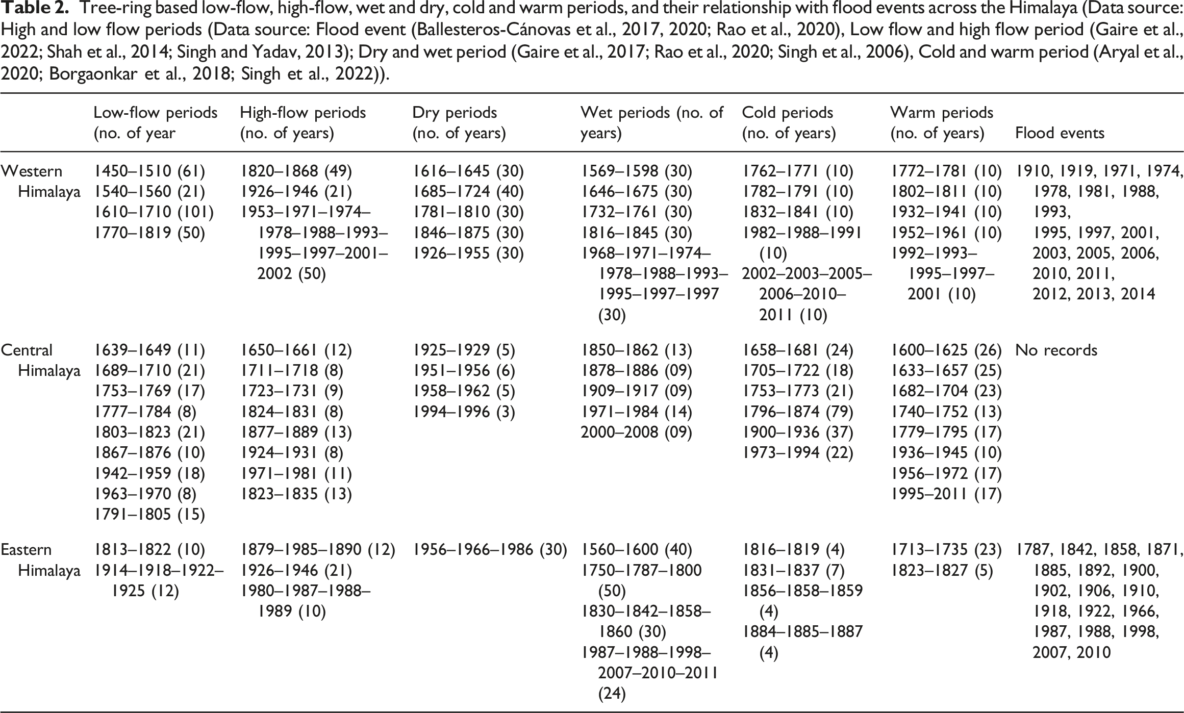
Tree-ring based studies in the Himalaya are not only useful for reconstructing streamflow but also for providing evidence of systematic shifts in hydrological functioning such as between wet and dry periods, high- and low-flow periods, and their relationship with flood intensity (Figure 4). Although these studies have been undertaken in different locations in the Himalaya, there are common periods of high and low streamflow, as well as wetter and drier conditions. A reconstructed 50 year period of high-flows from 1953 to 2002 (Singh and Yadav, 2013) matches a reconstructed 30 years long wet period from 1968 to 1997 (Singh et al., 2006). The Western Himalaya has experienced several prolonged low flows (e.g. 50 to 100 years) and dry periods (e.g. 30 to 40 years), compared to Central and Eastern Himalayas where the length of these periods are relatively shorter (i.e. between 10 and 20 years). Such long period of low flow in the Western Himalayan rivers can be caused by below average winter snowfall (Cook et al., 2013). This can be linked with the increasing drought risk in Western Himalaya (Ahmad et al., 2020; Khan et al., 2020, 2022). Unlike in the western Himalaya, the frequencies of high-flow and wet periods along with flood events have increased in the Central and Eastern Himalayas. This is likely due to long-term changes in climatic conditions, particularly changes in the Indian Summer Monsoon. Periods of prolonged low and high flow periods, dry and wet periods, and their relationship with the increasing frequencies of flood events across the Himalaya (Data source: flood events (Ballesteros-Cánovas et al., 2017, 2020; Rao et al., 2020); low flow and high flow periods (Gaire et al., 2022; Shah et al., 2014; Singh and Yadav, 2013); dry and wet periods (Gaire et al., 2017; Rao et al., 2020; Singh et al., 2006); cold and warm periods (Aryal et al., 2020; Borgaonkar et al., 2018; Singh et al., 2022).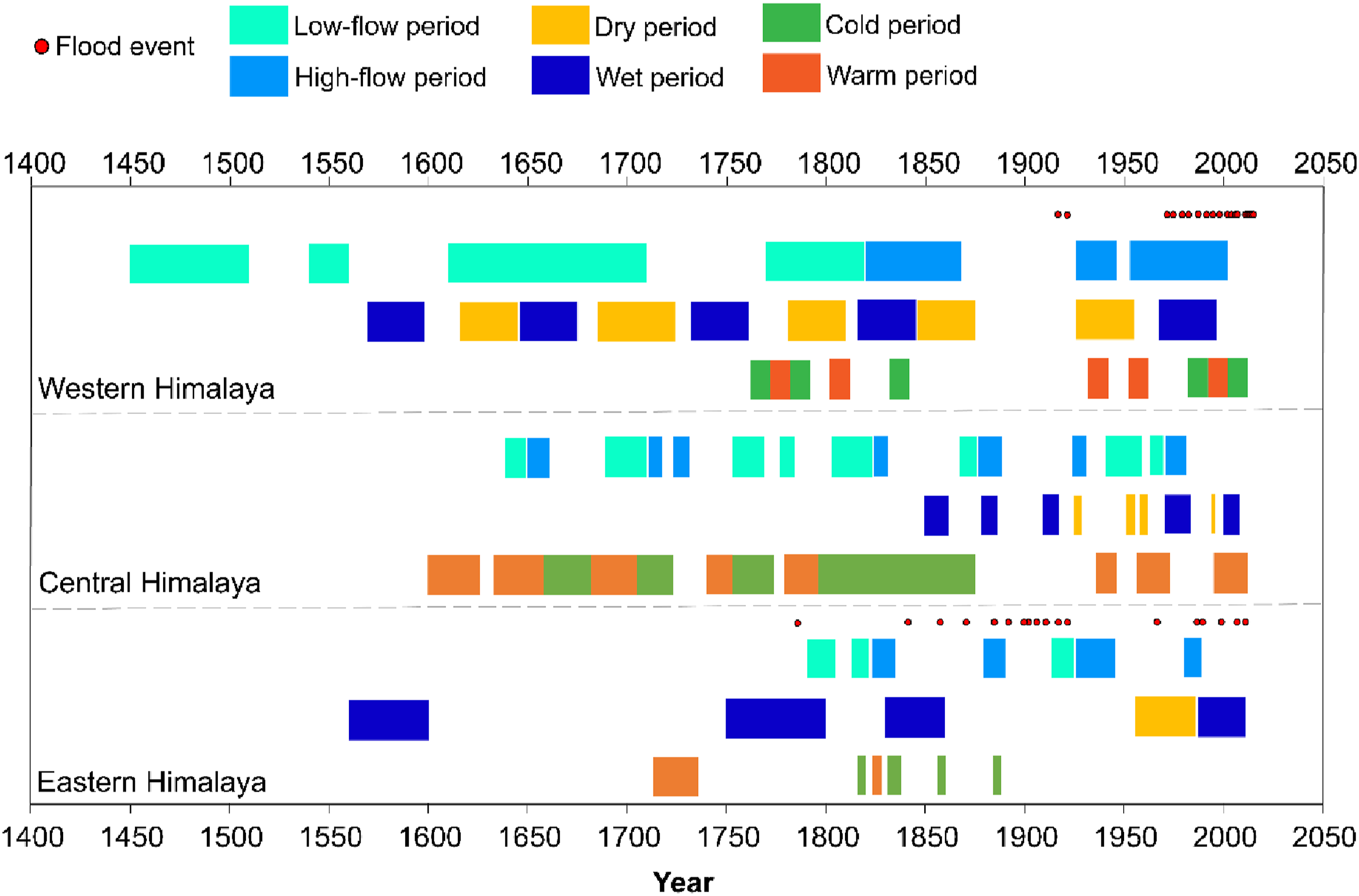
Tree-ring based low-flow, high-flow, wet and dry, cold and warm periods, and their relationship with flood events across the Himalaya (Data source: High and low flow periods (Data source: Flood event (Ballesteros-Cánovas et al., 2017, 2020; Rao et al., 2020), Low flow and high flow period (Gaire et al., 2022; Shah et al., 2014; Singh and Yadav, 2013); Dry and wet period (Gaire et al., 2017; Rao et al., 2020; Singh et al., 2006), Cold and warm period (Aryal et al., 2020; Borgaonkar et al., 2018; Singh et al., 2022)).
Reconstructions of flood events
Besides streamflow, tree rings can be central to reconstruct paleofloods (Stoffel and Bollschweiler, 2008) with a yearly precision (Ruiz-Villanueva et al., 2010). Such information can be extracted by identifying anatomical deformities in tree rings (e.g. cell damage) and paleo-stage indicators (PSI) on stems (Ballesteros et al., 2011). A PSI is a record of the damage at a certain height in a tree that ideally represents water-level during a flood (George, 2010). PSIs in trees that lead to anatomical deformities in tree rings may also be useful for the reconstruction of magnitude-frequency relationships that are used for risk assessment and engineering design (Stoffel, 2010), but establishing such relationships are extremely challenging particularly in ungauged or poorly gauged catchments (Ballesteros-Canovas et al., 2020). Moreover, transforming such information into hydraulic models needs to use numerical and statistical algorithms. One such example is to use a Bayesian Markov Chain Monte Carlo (MCMC) algorithm due to its advantage of providing a complete representation of large and historical flood records by deriving flood quantiles (i.e. amount of water corresponding to a flood return period, for example, 10, 100, 500 or 1000 years) in a homogeneous region (Gaume et al., 2010; Reis and Stedinger, 2005). It then systematically allows for an estimate of the peak discharge of particular events (Jarrett and England, 2002). These methods have proved successful for detecting paleoflood events from tree rings in different river basins around the world (Ballesteros et al., 2011; Ballesteros-Cánovas et al., 2011; Ballesteros-Canovas et al., 2020; Díez-Herrero et al., 2013; Génova et al., 2018; Harrison and Reid, 1967; Quesada-Román et al., 2020; Ruiz-Villanueva et al., 2010), supporting the feasibility of similar work in the Himalaya (Ballesteros-Cánovas et al., 2015, 2017, 2020).
During recent decades, the frequency and magnitude of flood events in the Himalaya have been reported as increasing in parallel with rising temperature and decreasing precipitation including and a weakening of the summer monsoon under changing climate (Gaire et al., 2019, 2022; Panthi et al., 2017; Zhan et al., 2017). A number of dendrochronological studies are available (the majority in the western Himalaya) that have reconstructed paleofloods using PSI marks (e.g. scars) in the trees adjacent to the river. For instance, Ballesteros-Cánovas et al. (2020) identified 64 flood events in the Kashmir valley, which were dated back to the early 7th century and estimated the magnitude of these historical floods including the biggest flood in 2014 (2200 m3s−1). In another study, Ballesteros-Cánovas et al. (2017) successfully reconstructed 33 past flood events in the Kullu valley. In the eastern Himalaya, Speer et al. (2019) reconstructed three flood events (1967, 1989 and 2009) in the Dhur river, Bhutan. The 2009 flood was closely associated with one of the most severe cyclones in recent decades (1940–2018) in May 2009. In the Brahmaputra river basin in the eastern Himalaya, Rao et al. (2020) undertook streamflow reconstruction using multiple ring-width chronologies available in the International Tree Ring Databank (ITRDB) and revealed that the tree rings recorded a total of 18 flood events, including 12 historical floods and 6 floods (in 1966, 1988, 1987, 1998, 2007 and 2010) during the recent instrumental period (Table 2). The majority of the historical floods occurred during wet and high flow periods with a drastic increase in frequency and magnitude in the last century (Figure 4). It is projected that the frequency and magnitude of not only hydrologically driven flood events but also other extreme events such as landslide lake outburst floods (LLOFs) and glacial lake outburst floods (GLOFs) will continue to increase in the Himalaya (Islam and Patel, 2021; Ruiz-Villanueva et al., 2017; Schwanghart et al., 2016; Veh et al., 2020; Zheng et al., 2021). These extreme events impact the normal growth of trees and this may be seen in tree-ring anomalies such as asymmetric rings (Shroder, 1978; Šilhán and Stoffel, 2022). By analysing growth disturbances in tree rings, Zhang et al. (2019) reconstructed landslides in 1703, 1816, 1848, 1863, 1913, 1970 and in 1982 in the Qilian Mountains in China. In the northern Tien Shan Mountains of Kyrgyzstan, Zaginaev et al. (2016) reconstructed 27 GLOF events between 1877 and 2015 based on anatomical deformities in tree rings. These studies show the potential of using tree rings for reconstructing past extreme events in the Himalaya. However, dendrochronological studies aimed at reconstructing paleofloods are not widespread across the Himalaya (Ballesteros-Cánovas et al., 2017, 2020; Rao et al., 2020; Speer et al., 2019). This limits our knowledge about the magnitude of unrecorded paleoflood events in many Himalayan river basins. More tree-ring based hydrological studies may be crucial not only for developing long-term past flood records but also establishing relationships with wet and dry periods, periods of high-flow and low-flow at the basin scales.
Whilst PSI based tree-ring analysis may have high potential for reconstructing paleofloods, this technique can be biased towards larger flood events which last for several days or weeks. In contrast, extreme events like GLOFs or LLOFs usually have a shorter duration (e.g. a few hours) which may not leave any noticeable PSIs. However, they may significantly affect development of the growth cells. In such cases, quantitative wood anatomy is useful for detecting particular anatomical features in trees and for reconstructing those extremes in the past (Ballesteros et al., 2010; Copini et al., 2016; Stoffel and Corona, 2014).
Tree-ring stable isotope composition
The isotopes of an element have similar chemical properties but due to their mass differences, their physio-chemical properties are different. This leads to isotopic fractionation between different molecules containing the isotopes of the same element. The extent of fractionation reflects environmental conditions including temperature, relative humidity and rainfall intensity at the time at which water is taken up into the wood (McCarroll and Loader, 2004). Therefore, by separating whole tree rings or extracting the tree-ring cellulose following standard procedures (Green, 1963; Kagawa et al., 2015; Loader et al., 1997) and measuring their isotopic composition, it is possible to acquire a wide range of potentially useful information related to plant physiology, and hydroclimatic parameters such as relative changes in temperature and also sources of water (glacial melt water, rain or snow water infiltration) at annual to intra-annual resolution (Hill et al., 1995; Leavitt, 2010; Lehmann et al., 2021; Liu et al., 2004; Loader et al., 1997, 2003; McCarroll and Loader, 2004; McCarroll and Pawellek, 2001; Vuaridel et al., 2019). With methodological advancement, the study of tree-ring stable isotopes has opened up a wide range of possibilities for high-resolution climatic reconstruction from a variety of species (Loader et al., 2003; McCarroll and Loader, 2004).
The first tree-ring stable isotope study in the Himalaya was conducted by Ramesh et al. (1985) in the Kashmir Valley in western Himalaya. Since then a number of other studies were added across the Himalaya and in the Tibet plateau (Managave et al., 2020; Pandey et al., 2020; Ramesh et al., 1989; Sano et al., 2010, 2013, 2017; Singh et al., 2019b; Zeng et al., 2017). Ramesh et al. (1985) analysed the long-term consistency of 79% for deuterium (δD) and 84% for carbon (δ13C) isotope compositions of tree rings in Kashmir valley. The δD of the precipitation limited trees can reveal climate information including monsoon variability (Ramesh et al., 1989). The use of δD of the carbon-bound hydrogen isotopes (δ2H) and oxygen isotopes (δ18O) may allow for a quantification of changing moisture seasonality (e.g. pre- and post-monsoon, mid-latitude westerlies) over long-time scales. For the central Himalaya, Singh et al., (2019b) reconstructed 273 years of June–July monsoon rainfall using δ18O chronologies from three different species (Abis pindrow, Picea smithiana, Aesculus indica) from the Dingad valley of Uttarakhand. Their findings show that mean δ18O chronology correlates positively with temperature (r = 0.40, p < .01) and negatively with precipitation (r = −0.60, p < .01) and with scPDSI (r = −0.41, p < .01) in July. The negative relationship between tree-ring growth and measured δ18O in them is often known as the ‘rain-out effect’ or the ‘monsoon effect’ in monsoon-dominated regions. This effect is getting stronger in the recent decades due to decreasing rainfall (An et al., 2019; Singh et al., 2019b), which increases the relative importance of the monsoon season rainfall that will likely lower δ18O values. Several studies in the recent past have identified a long-term decreasing pattern of the Indian Summer Monsoon across the Himalaya (An et al., 2019; Xu et al., 2018). However, unlike the generally decreasing precipitation trend, an increase in precipitation has also been observed in the Himalaya. A study by Shrestha et al. (2012) found that the average annual precipitation has increased by 163 mm with the highest increase of 269 mm in the Brahmaputra valley in the eastern Himalaya during their 25 year analysis period (1982–2006). The overall increase in precipitation in the Himalaya is most likely due to an increase in atmospheric moisture content in recent decades which favours more intense rainfall and snowfall events (Trenberth et al., 2003). In contrast, the increase in moisture content in the atmosphere leads to the depletion of 18O due to the increased rain-out and a reduction in evapotranspiration, lowering the tree-ring δ18O values (Farquhar et al., 2011; Roden et al., 2000). A century-long (828–1998) δ18O record from the Karakoram mountain range in the western Himalaya allowed for a reconstruction of 1041 years (950–1990) of October (previous year) to September (current year) precipitation (Treydte et al., 2006). Such long records of precipitation variabilities were interpreted based on a significantly negative correlation (r = −0.58, p < .001) between amounts of precipitation and measured tree-ring δ18O during 1898–1990. Similar results of negative correlation (r = −0.40, p < .001) between the tree-ring δ18O chronology and October (previous year) to March (current year) precipitation have also been reported in the Lahaul-Spiti region of Himachal Pradesh, in the western Himalaya (Managave et al., 2020). Unlike the relationship between ring widths and climatic conditions, stable isotope compositions (δ18O, δ2H) correlate positively with temperature and negatively with precipitation across the Himalayas, and the correlations are numerically higher (Figure 3(d)–(e)). Therefore, more tree-ring stable isotope studies using different species may help to improve reconstruction of past climatic conditions, particularly the Himalayan monsoon variabilities.
Future tree-ring research directions in the Himalaya
To obtain an overview of Himalayan tree-ring-based hydroclimatic reconstruction and to identify research gaps, Table 1 provides a summary of key studies. The resulting 173 scholarly articles separated by their spatial coverage of western, central and eastern Himalaya (Figure 5(a)) and grouped into three broad categories such as quantitative wood anatomy, tree-ring stable isotopes and traditional dendrochronology (Figure 5(b)). There has been a consistent increase in terms of total number of tree-ring studies, although the eastern Himalaya remains poorly researched. Studies to date remain focused on traditional growth-climate relationships with very few studies using TRSI and even fewer using QWA approaches. Given these data, this section reviews the research needs for future dendrochronological studies in the Himalaya, focusing on the Himalayan hydrology. Number of tree-ring papers over the years in parts of the Himalaya (a), and theme-based (b) over the years.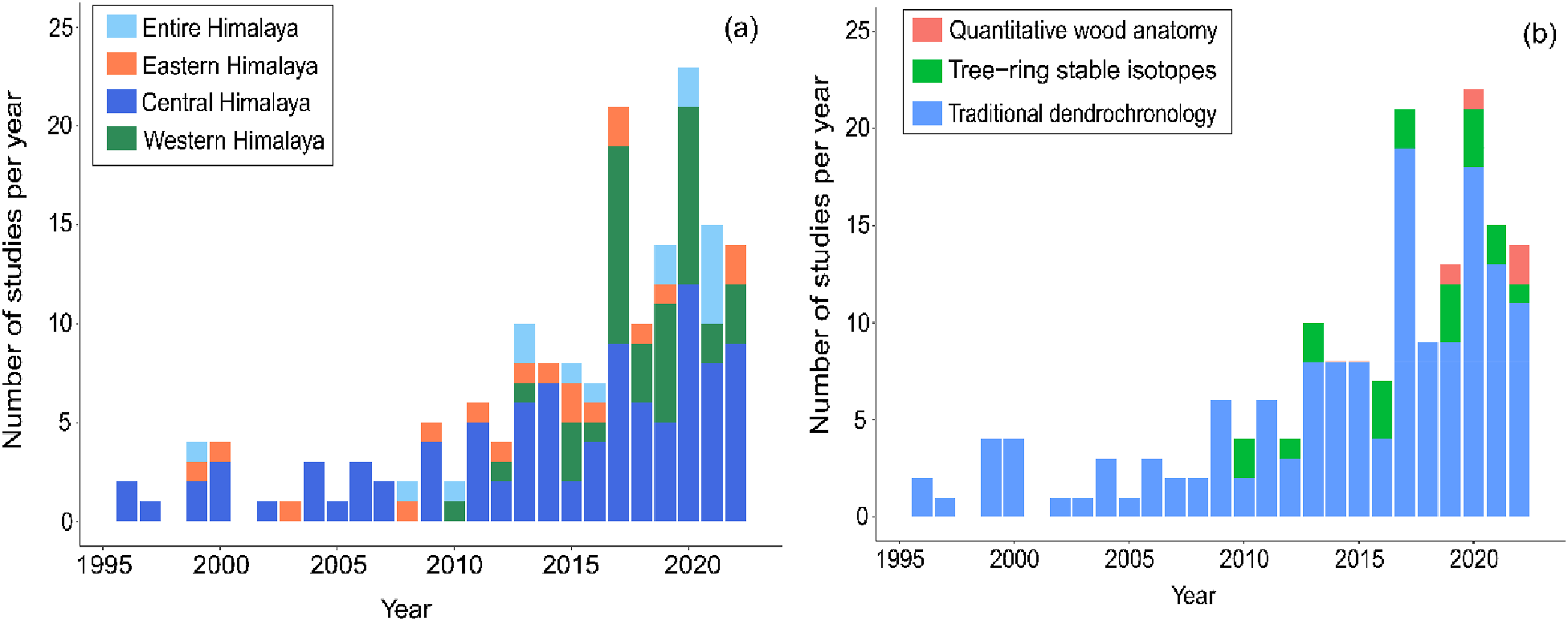
It is clear that tree-ring based hydrological reconstructions at different spatial (i.e. smaller catchment to larger river basin) and temporal (i.e. century to millennia) scales have improved our understanding of the dynamics of water resources and extreme events across the Himalaya (Ballesteros-Cánovas et al., 2017, 2020; Cook et al., 2013; Khan et al., 2022; Rao et al., 2020; Shah et al., 2014). However, whilst the annual focus has been valuable, there has yet to be significant consideration of intra-annual hydroclimatic variabilities in the Himalaya. Recently developed techniques in dendrochronology, notably those that go beyond annual tree-ring width (TRW) to consider intra-annual earlywood width (EWW), latewood width (LWW), minimum earlywood density (MND), maximum latewood density (MXD) may be valuable. They may be further aided by blue intensity (BI), quantitative wood anatomy (QWA) and tree-ring stable isotope (TRSI) analyses.
Maximum latewood density
Tree-ring width measurement has been considered as the traditional method in dendrochronology for climate studies since the beginning of dendrochronology (Fritts, 1976; Fritts et al., 1965). However, more recently, the analysis of maximum latewood density (MXD) has been recommended (Wilson et al., 2014, 2021) and is providing substantial amounts of paleoclimatic information as compared with the TRW (Büntgen et al., 2017; Esper et al., 2012; Wilson and Luckman, 2003). The method has become more popular with the development of x-ray densitometry techniques for measuring wood density (i.e. the ratio between the weight and volume of a piece of wood) to micrometre precision (Pagotto et al., 2017; Polge, 1970; Schweingruber et al., 1978). The potential of wood density parameters such as MXD for dendroclimatic research using coniferous species was noted in the late 1990s in the Himalaya (Borgaonkar et al., 2001; Hughes, 1992, 2001; Pant et al., 2000). Both the MXD and MND are strongly influenced by pre-monsoon summer climate. For instance, the MXD of C. deodara from the western Himalaya appears to be positively correlated with pre-monsoon temperature (r = 0.39, p < .01) and precipitation (r = 0.41, p < .01) between March and May (Pant et al., 2000). Although the climatic responses vary for different species and from place to place, studies show that compared to MXD, the MND records stronger climate signals in the western Himalaya (Borgaonkar et al., 2001). In the Kashmir valley, Hughes (2001) found that the relationship between MXD and temperature became weaker from the middle of the 20th century, but no long-term trend was observed. Such trends of weakening growth-climate relationship and shifting of climatic signals may not be detectable using TRW or MXD at annual resolutions. It creates an offset between the tree-ring based reconstructed temperature and observed temperature that is known as the divergence problem (D’Arrigo et al., 2008). Much higher (e.g. intra-annual) resolution studies are needed but are generally confined to restricted geographical locations in the Himalaya. In the arid part of the Karakoram region located in the western Himalaya, warmer summer temperature has been shown to influence intra-annual (both earlywood and latewood) growth of Myricaria elengans (Dolezal et al., 2016). Their study also recorded a similar trend of a weakening growth-climate relationship (Hughes, 2001) and a switching of the dominant climatic signals as the result of rapid warming since the 1990s. Due to climate and glacier fluctuations, such as a recent trend of temperature warming and irregularities in monsoon patterns, Himalayan trees may have numerous missing or false rings (Cherubini et al., 2003; Schweingruber et al., 1990). The latter also known as intra-annual density fluctuations (IADFs; (Battipaglia and Cherubini, 2022; Battipaglia et al., 2010, 2014; Bräuning et al., 2016; De Micco et al., 2012, 2014; Singh et al., 2016). They may also produce frost rings (LaMarche and Hirschboeck, 1984; Nautiyal et al., 2019), which develop when temperature goes below freezing point for some time during the growing season. Under freezing conditions, the outermost part of the weaker cells of these rings break and create anatomical deformities in the rings (Glerum and Farrar, 1966; Harris, 1934). Unfortunately, not many studies have analysed the anatomical deformities of frost rings, false or missing rings and their relationships with the climate in the Himalayan context. There are opportunities to measure not only TRW or MXD but also EWW and LWW to understand climate dynamics (Nautiyal et al., 2019); and to identify altitude-related switches between different kinds of growth rate limitation, especially given the considerable altitudinal ranges of the Himalaya (Dolezal et al., 2019).
Blue intensity
The development of blue intensity (BI) analysis has opened a new possibility to the community for understanding relationships between tree growth and hydroclimate at much higher temporal resolution by quantifying earlywood and latewood phases of tree-ring growth during the growing season (Campbell et al., 2011; McCarroll et al., 2002; Rydval et al., 2014). The method of blue intensity captures the reflectance of blue lights from the tree rings of the scanned images (Rydval et al., 2014). The available blue light in the surface of the rings is the result of lignification of tracheid cells as a response to drought and heat stress. Tracheid cells are the long, lignified cells available in the xylem of vascular plants and their primary purpose is to transport water through the xylem; whereas lignification is the process of depositing lignin (organic polymers) to strengthen the plant vascular body. The BI technique follows similar principles to the measurement of MXD. However, one reason to use BI over the MXD method is its cost-effectiveness and straight-forward processing (Kaczka and Wilson, 2021; Wilson et al., 2014). As a result, the BI measurement technique has now been incorporated into climate reconstructions for temperature (Björklund et al., 2020; Frank and Nicolussi, 2020; Rydval et al., 2014), and precipitation (Seftigen et al., 2020) particularly for softwood coniferous species (Schwab et al., 2018). However, the potential of this technique is still unexplored in the Himalaya. Schwab et al. (2018) conducted one of the first studies using BI to analyse a century-long growth-climate relationship in the treeline in Nepal, central Himalaya. They found a significant negative correlation of BI with mean winter temperature (r = −0.43, p < .05) and positive correlation with monthly standardised precipitation-evaporation index or SPEI (r = 0.46, p < .05) of the previous year. This further showed that tree growth in the monsoon-dominated belt of the Himalaya is mostly influenced by moisture availability. In spite of the continuous methodological development of BI, more studies are needed to evaluate the range of blue intensity parameters such as the earlywood maximum blue intensity (EWB), latewood minimum blue intensity (LWB), as well as delta blue intensity (DB) for various tree species (Wilson et al., 2021) across the Himalaya not only for climatic but also for paleo-hydrological analysis.
Quantitative wood anatomy
Dendroanatomy, most commonly called Quantitative Wood Anatomy (QWA) is a recent development in the field of dendrochronology and has recently become a popular tool in the tree-ring community (Pandey et al., 2018). QWA is a method for analysing variations in the xylem anatomical features of trees, shrubs and herbaceous species and the growth, function and response to the environment (Von Arx et al., 2016). The QWA has the ability to analyse cell-to-cell growth disturbances at micro-level resolution and to provide more detailed information such as the timing and magnitude of lignification for BI-based hydroclimatic reconstructions (Buckley et al., 2018). Also the damages or changes in xylem structure (the living cells that conduct water) produced by external disturbances or geomorphic processes such as landslides or snow avalanches (Stoffel and Corona, 2014) may be identified. The application of automatic image processing techniques such as ROXAS (Von Arx and Carrer, 2014) make the analysis of quantitative data easier and faster (Fonti et al., 2009; Von Arx et al., 2016). However, it needs very high quality data at higher temporal and spatial resolutions, as well as proper and intense sample collection (Von Arx et al., 2016). There have been several studies in the recent past that have considered the response of different species to climate by using anatomical deformities in the xylem structure (Diaconu et al., 2017; Fonti et al., 2009; Pritzkow et al., 2014). Also, by analysing the impacts on the growth of vessel lumen area, the water conducting tissue of plants which distinguishes hardwood from softwood, it is possible to identify anatomical responses after extreme events such as flash-floods or rockfalls. In most cases those studies have been limited to Europe, including Spain (Ballesteros et al., 2010; Camarero and Ortega-Martínez, 2021), the Netherlands (Copini et al., 2016), Sweden (Pritzkow et al., 2014), Germany (Diaconu et al., 2017), Switzerland (Gärtner-Roer et al., 2013), etc.
In terms of climate studies, only a few have applied QWA in the Himalaya (Chauhan et al., 2022; Dolezal et al., 2019; Li et al., 2021; Sharma et al., 2011). There are no QWA based tree-ring studies available in relation to natural hazards. However, given the fact that an extreme flood event can damage the internal cell structure of a tree, reducing the vessel lumen area from 40 to 70% (Ballesteros et al., 2010; Camarero and Ortega-Martínez, 2021; Copini et al., 2016), it may be a valuable method for palaeoflood analysis, particularly in the Himalaya where there is a growing evidence of severe flood risk relating to glacial lake outburst and landslide dam breach floods.
Tree-ring stable isotopes
In addition to the above methodological developments, the biggest added value to the science of dendrochronology may come from the analysis of whole wood or cellulose extracted tree rings for their stable isotope compositions (e.g. carbon, oxygen, and hydrogen). A number of studies have now been conducted using tree-ring stable isotopes (TRSI), but these are confined primarily to the paleoclimatic domain. Application of TRSI analyses to wider questions, such as hydrological histories in rivers, has been confined mostly to Europe (Battipaglia et al., 2010; Bert et al., 1997; Kress et al., 2009; Lehmann et al., 2021; Vitali et al., 2022) and America (Belmecheri et al., 2014; Levesque et al., 2019; Szejner et al., 2021; Van de Water et al., 2002). Studies in Europe have shown how trees growing in deglaciated areas downstream of glaciers can benefit from glacial runoff closer to meltwater streams (Leonelli et al., 2014). Measuring stable isotope compositions, particularly δ18O and δ2H values, can allow changing water sources to be traced in glacierized river basins in high mountains. Leonelli et al. (2014) measured the δ18O from tree-ring cellulose at different locations (i.e. at the proximity and at the distal to the proglacial stream) downstream of Miage Glacier in Italy and found that trees accessing the glacial meltwater had slightly lower (−0.9 ‰) δ18O (i.e. mean −15.7 ‰) compared to the δ18O (i.e. mean −15.2 ‰) of trees away from the proglacial stream accessing rainwater and local snowmelt only. A similar trend of decreasing δ18O values in the trees at the proximity to the river in the downstream of Forni Glacier in Italy also indicated climate change induced higher glacial melt (Leonelli et al., 2019). In South America, Vuaridel et al. (2019) analysed δ2H and found similar results in Patagonia, as the trees close to the proglacial stream (i.e. mean δ2H of −154.5 ± 5.1 ‰) had the highest depletion of 2H (−22.5 ‰) compared to the trees at higher elevation away from the proglacial steam (mean δ2H −132.0 ± 3.7‰) in the Olguin glacier basin in Chile. This depletion also increased with global warming indicating higher proportions of glacier melt waters with increasing average summer temperatures. In non-glacierized river basins, unlike the trend of depletion in isotopic values, there could be an increase in isotopic composition over time related to increases in temperature and precipitation, and human-interference such as building dams on the stream to interrupt natural glacier-meltwater flow.
In the Himalaya, besides the snow and glacier meltwater contributions due to changing climate, hydrology is strongly influenced by the Indian Summer Monsoon (Boral et al., 2019). This alters the stable isotopic compositions in Himalayan rivers. Some efforts have been made to sample Himalayan rivers in ways that allow identification of different water sources such as precipitation, lake and river water, groundwater (Ali et al., 2020; Boral et al., 2019; Dubey et al., 2020; Kumar et al., 2020; Verma et al., 2018). However, these studies have not been able to reveal long-term temporal changes in stable isotopic compositions over a larger spatial scale. This is where the measurement of TRSI is relevant and may help us to improve our understanding about how different water sources are changing. This would be a clear advance on current studies of TRSI in the Himalaya which focus upon the reconstruction of temperature and precipitation, and which are mostly confined within the western and central part of the Himalaya. No studies have focused on the TRSI compositions at both annual (i.e. the annual ring-width) and intra-annual (i.e. earlywood and latewood ring-width) resolutions to deal with snow and glacier meltwater contributions to changing water sources in the Eastern Himalayan river basins.
Conclusion
The Himalaya Mountain Area is a climatically and hydrologically complex mountain range with a very large spatial extent, one intimately bound with society through its influence on water resource availability and natural hazards. It is also a region where in hydrological terms much still needs to be learned as reliable instrumental records are relatively few given the large extent of the Himalaya, its climatic complexity and strong, spatial hydroclimatic gradients. This is a primary motivation for developing applications of dendrochronology in the Himalaya, to extend the geographical and historical coverage beyond that of instrumental records. In this paper, we have reviewed progress in the application of dendrochronology of the Himalaya. We have shown that significant understanding beyond the instrumental records of temperature, precipitation and wider hydrological changes can be achieved through the application of more traditional dendrochronological approaches, as well as newly developed methods. Studies have also tended to focus more on the western and central Himalaya. More recent developments that are relatively rare include the analysis of wood densities and anatomies, blue intensity, and stable isotope studies. Given the potential for these more recent methods and techniques to unravel intra-annual understanding, combined with evidence in the instrumental record of more subtle shifts in Himalayan climate (e.g. the timing of the onset of the summer monsoon, moisture stress), the application of such newer techniques is likely to be of significant value. As such, dendrochronological research could help improve hydroclimatic interpretations including annual and seasonal temperature and precipitation trends, runoff, changes in water sources and also changing flood risk in the greater Himalaya region.
Footnotes
Declaration of conflicting interests
The author(s) declared no potential conflicts of interest with respect to the research, authorship, and/or publication of this article.
Funding
The author(s) disclosed receipt of the following financial support for the research, authorship, and/or publication of this article: This work was supported by the University of Lausanne; Doctoral Mobility Fellowship (Mobi.Doc)-MD-0036 and Federal Commission for Scholarships for Foreign Students (FCS); Swiss Government Excellence Scholarship.