
Abstract
This editorial reports on a horizon scan exercise that was undertaken to identify new frontier topics, new or emerging themes/concepts, or new philosophical questions of relevance to physical geography. Researchers with broad geographical and disciplinary scope, all of whom were members of the journal's editorial board or editorial advisory board, were invited to join a horizon scan panel. The horizon scan Chair canvassed panel members for ideas, resulting in an initial 32 independently proposed topics. Similar topics were merged by the Chair, and panel members were then invited to vote on and score anonymously the remaining 28 topics, bearing in mind the perceived importance/relevance and novelty for the discipline. The final ranking and sifting phase produced a list of 12 topics, which were categorised as being either new study areas or new epistemological frameworks for physical geography. In this editorial, we outline these 12 topics, some of which have been inspired by developments outside of the discipline, but we identify how potentially fertile contributions could be added by physical geographers. We discuss how new studies of extreme event geographies, the impacts of compound stressors, cross-system pollution and toxicity, the geomorphological basis of zoonoses, ancient environmental DNA, the projection and visualisation of landscape futures, and planetary sciences can all benefit from additional physical geography perspectives. We then consider the ways in which physical geographers may engage further with new approaches in personalised and internet-of-things monitoring, artificial intelligence, innovative technologies for teaching physical geography, the study of human-climate impacts, and the raising of the profile of physical geography thinking alongside other knowledge forms. We encourage more physical geographers to apply their unique skillsets and ways of thinking to these topics. The journal will welcome new submissions, or proposals for special issues, that address these topics from physical geographers and their colleagues.
I Introduction
With recent changes in the journal’s editorial board, coupled with a recognition of the extremely broad remit of ‘physical geography’ that results in topically diverse papers appearing in the journal, we decided to undertake an exercise to identify and query emergent topics in the discipline. Following Harden et al.'s (2020: 11) recent contribution to the journal, we define the discipline of physical geography as anything that includes “climatology, geomorphology, hydrology, pedology, and also biogeography as practiced by geographers, which includes landscape ecology.”
The horizon scan exercise described herein was driven by a desire to balance the reactive model of the journal with a more proactive stance that drives the discipline to focus on emergent topics, and specifically those that leverage the physical geographer’s expertise and toolkits. The exercise was also partly inspired by editorial practices. For example, when we receive a submission, the first job of the handling editor is to decide whether the content falls within the remit of the discipline of physical geography, and then to evaluate whether a specific manuscript delivers progress within our discipline. These are challenging considerations, particularly in view of the fuzzy boundaries of the discipline, and so undertaking a horizon scan to identify emergent topics was felt to be a helpful endeavour for defining timely, core areas of interest.
Inspired by Sutherland et al.'s (2023) horizon scan in the field of biological conservation (an annually recurring endeavour which is now in its 15th year), we led a similar exercise with the following core goals that were focused on the discipline of physical geography. These were to identify new frontier topics, new or emerging themes/concepts, or new philosophical questions of relevance to the discipline. Horizon scanning can be undertaken as a collaborative exercise and, as in the case of Sutherland et al.'s (2023, and previous) biological conservation horizon scans, will optimally involve transdisciplinary actors from beyond academia so that emerging threats and opportunities can be more holistically framed, and strategic responses can be imagined. However, since this was the first such exercise in physical geography, we intentionally kept the contributors narrow i.e., constrained to the journal’s editorial board and editorial advisory board members.
II Methods
Stage 1: Topic identification
Members of the editorial board and editorial advisory board (comprising 24 people with a spread of expertise across the physical geography spectrum, and representing a global geographical spread) were asked to canvass their collegial networks and submit two to five topics that are “novel, relatively unexplored, and likely to become important within physical geography research in the next 5–10 years”. Topics were proposed using Google Forms. Topic proposers were anonymous to everyone, except the Chair of the horizon scan panel (K. Anderson). On the Google Form, each topic proposed had to be given a brief title, along with an accompanying paragraph explaining the novelty or importance of the topic, and a short list of any key publications that were relevant in supporting the topic. A period of around 3 months was given for participants to submit ideas. This exercise took place between January and April 2023. In total, 32 proposals were made and these reflected a spread of ‘frontier topics’, with most (but not all) having some justification for their inclusion.
Stage 2: Sorting and voting
Our approach was inspired by Sutherland et al. (2023), but differed in detail since this was the first such exercise in physical geography, and we were not afforded the same resources. The Chair of the horizon scan panel read the case made for each of the 32 proposed topics. If there was significant commonality across different topic proposals, they were condensed into a single topic, with the separate justifications combined. No proposed topics were removed at this stage. This resulted in a total of 28 separate topics. The same 24 people who were involved in stage 1 were then invited to vote anonymously. A spreadsheet containing the topics, each with a unique number identifier, was shared via Google Forms with the participants. Votes were cast online using Google Forms, which enabled a score to be assigned to each topic by each person. Scoring was designed to range between 1 (of little or no importance/relevance to physical geography and of little or no novelty) and 10 (of great importance/relevance to physical geography and of great novelty).
When voting, people were asked to consider two criteria for scoring: (1) (2)
Voters were advised to try and achieve some discrimination by using the mark range. For example, a topic that is deemed to be of importance/relevance for physical geography in the sense of having a positive impact, but that is not deemed to be especially novel, would not score as highly as a topic that is deemed to be of importance/relevance for physical geography in the sense of having a positive impact and also be deemed to be novel.
Stage 3: Post-voting ranking and sifting of topics
The Chair of the horizon scan panel then summed the scores for each of the 28 topics to a total value and a median was calculated. This approach highlighted both the most popular topics (highest total scores) and the topics with more uniform high scores (median equal to, or greater than, 6).
III Results
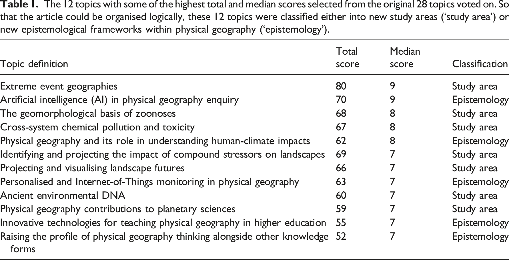
The 12 topics with some of the highest total and median scores selected from the original 28 topics voted on. So that the article could be organised logically, these 12 topics were classified either into new study areas (‘study area’) or new epistemological frameworks within physical geography (‘epistemology’).
In the sections that follow, the 12 top ranked topics are presented thematically (by study areas or epistemological frameworks) rather than according to rank. We provide short descriptions of their relevance to the discipline of physical geography, making brief reference to some key publications within or outside the physical geography discipline. Indeed, in many cases, these topics have been inspired by developments outside of our discipline, but potentially fertile contributions could be added by physical geographers.
IV New study areas for physical geography
Extreme event geographies
The causal links between climate change (e.g., current atmospheric warming) and the frequency and magnitude of extreme events (e.g., heat and cold waves, heavy precipitation, megadroughts, windstorms) is a topic of ongoing research by physical geographers and researchers in other disciplines (Bellprat et al., 2019; Fischer et al., 2018; Hulme, 2014; Stott et al., 2016; Swain et al., 2020; Trenberth et al., 2015). Consequently, there is a growing demand for studies defining what these extreme events constitute and more investigations into the mechanisms and impacts of such events across a range of spatial and temporal scales (IPCC, 2021; McPhillips et al., 2018).
Whereas attribution of extreme weather events to anthropogenic climate change is already a rapidly developing, hot topic in climatology, a next stage should be attribution studies of the effects of changing extreme event regimes on environmental responses that are a process step or two removed from atmospheric warming, such as increased flooding (Gudmundsson et al., 2021; Hirabayashi et al., 2013), modified fire regimes (Jones et al., 2022; Senande-Rivera et al., 2022), biogeographical range shifts (Casson et al., 2019; Cohen et al., 2021), and threatened ecosystem resilience (Neilson et al., 2020). There is a long tradition of studies of climate impacts and interactions in biogeography, geomorphology, pedology, and hydrology (e.g., Lafon et al., 2022; Malanson et al., 2019; Naylor et al., 2017; Phillips, 2007), but there is now an urgent need to establish ways of leveraging this knowledge to address contemporary environmental response attribution. Physical geographers would be well placed to undertake work that does so.
Furthermore, one of the most challenging and pressing research problems of our time is to address how the societal impacts of extreme events will be distributed across regions and populations. What role do societal drivers (e.g., decision-making processes) play in shaping the risk profile and vulnerability of diverse regions and communities and in identifying resource and disaster management strategies (Lahsen and Ribot, 2022; Raymond et al., 2020)? Physical geographers are well poised to tackle such questions given the longstanding tradition of research into climate dynamics, natural hazards, and ecosystem vulnerability and resilience.
Identifying and projecting the impacts of compound stressors on landscapes
Related to extreme event geographies is consideration of the future landscape changes that will result from ‘compound stressors’ (also termed ‘compound drivers’, ‘compounding effects’ or ‘compounding elements’; e.g., see Best and Darby, 2020; Zscheischler and Raymond, 2022). For example, what will be the synergistic or additive influences on landscapes resulting from climate changes and the biotic (plant, non-human animal) responses to those changes? Biotic responses to climate changes might include plant/non-human animal species losses (e.g., through local extinctions or migrations) or plant/non-human animal species gains (e.g., through immigration of native species or the spread of exotic species), and these responses may lead to cascades through biogeomorphological systems. As an example, recent work has shown how beaver migration into the warming Alaskan Arctic tundra over the last few decades has transformed the hydrological landscape, with the number of beaver ponds doubling in most areas between ∼2003 and ∼2017 (Tape et al., 2022). Expansion of beaver ponds feeds back to enhance permafrost melting rates and landscape instability, essentially exacerbating the effects of climate change (Tape et al., 2022). As a physical geography community, can we help to identify other examples of actual or potential links between climate change, biotic responses, and landscape changes, perhaps building on recent work that has refined the ecosystem engineering concept by looking at landforms as combined expressions of multiple reciprocally interacting species (Kim and Lee, 2022)?
Other compound stressors can be identified. For instance, consideration of future climate change impacts on river geomorphology and hydroecology is complicated by the potential for direct human impacts on river flow and sediment regimes (e.g., Best and Darby, 2020). Rivers are among the most human-modified systems on the planet, and in drylands particularly, many larger rivers (e.g., lengths >100 km) are already heavily impacted by large-scale water resource developments (e.g., Kingsford, 2006). In coming decades, the few remaining relatively free-flowing, large dryland rivers may come under greater pressure, particularly through water abstraction or flow regulation schemes. Such human impacts may exacerbate hydroclimatic changes by further reducing flow magnitude and frequency in downstream reaches (e.g., through increased water abstractions) or, conversely, may counteract hydroclimatic changes by augmenting flows, especially during low flow periods (e.g., through controlled dam releases). Changing flow regimes, and the associated changes to water quality and sediment loads, may have profound implications for channel-floodplain geomorphological processes and riparian ecology, potentially leading to further transformations of many dryland riverscapes (e.g., see Jaeger et al., 2017). In a putative Anthropocene time interval, when it has been suggested that human impacts are overwhelming the ‘great forces’ of nature (e.g., Steffen et al., 2007), physical geographers with interests in dryland rivers or rivers in other climatic settings could make a contribution to addressing these and other compound stressors.
Cross-system chemical pollution and toxicity
The production, release, and remobilisation of diverse chemical pollutants in the environment –– including legacy pollutants and emerging contaminants –– have increased dramatically in recent decades (Alpizar et al., 2019). Legacy pollutants, such as heavy metals and persistent organic pollutants, are materials that have been regulated but that remain in the environment long after deposition. Emerging contaminants are materials that pose a potential threat to humans and ecosystems (Diamond et al., 2011), but for which there are a lack of published health standards. They include pharmaceuticals, per- and polyfluoroalkyl substances (PFAS), microplastics, and other materials created entirely by humans (i.e., “novel entities”; One Earth Editorial Team, 2022). Wind, water, and waves transport these and other chemical pollutants through the environment. Pollutant deposition can occur downwind considerable distances and across system boundaries (political, geographic), with potentially adverse impacts on public health (Ashraf, 2017) and ecosystems (e.g., Saaristo et al., 2018).
Projections indicate that the global footprint of the chemical industry will continue to expand through increased production capacity, volume, and sale of chemicals (Alpizar et al., 2019). Annual plastic production alone is expected to more than triple between 2016 and 2050. The arising problem of transboundary plastic pollution has attracted a strong level of marine biological and marine geochemical research attention, with considerably less critical work within the field of physical geography. Nevertheless, recent work by physical geographers and others has explored the geomorphological and sedimentological controls on, and implications of, fossil fuel-derived plastics in the environment (e.g., Hurley et al., 2018; Russell et al., 2023). Coupled with changing climate and disturbance regimes that together are fuelling inter-system connectivity (see foregoing sections), it is likely that more people will be exposed to pollution in the future, and at greater distances from the source. More dust storms, wildfires, extreme floods, and other disturbances are already remobilising legacy pollutants and redistributing them into air, water, soil, and biota (e.g., Ponette-González et al., 2018). For example, wildfire smoke plumes often spread across international boundaries, exposing millions of people to hazardous air pollutants (e.g., lead, arsenic; Holder et al., 2023). Drying saline lakes also represent a source of metal-laced toxic dust to the atmosphere (Putman et al., 2022) and contribute to degraded air quality (Seltenrich, 2023) and public health impacts (Johnston et al., 2019). In cold regions, warming-accelerated release of microplastics, persistent organic pollutants, and other materials temporarily deposited and stored in glacial ice could represent a major health risk to downstream meltwater-dependent communities (Beard et al., 2022a, 2022b). In addition to these pollutants, there are a range of novel entities (e.g., carbon fibre composites, bioplastics, graphene), whose inputs, transformations, and outputs are little understood and require further consideration (One Earth Editorial Team, 2022). Understanding the nature, extent, drivers, and impacts of cross-system chemical pollution and toxicity undoubtedly will require productive collaboration between physical geographers and researchers in other disciplines.
The geomorphological basis of zoonoses
Given several global pandemics in recent decades, increasing attention is turning to the environmental drivers of zoonoses, which are defined as diseases that can be transmitted to humans from non-human animals (e.g., mammals, insects, reptiles, birds) (IPBES, 2020; UNEP and ILRI, 2020). Some research has focused on the role of weather/climate change or land use/vegetation change in heightening the risk of zoonotic disease emergence and transmission (e.g., Lambin et al., 2010), but typically there is very little consideration of the potential role of geomorphology. Might geomorphological processes (e.g., transfer of sediment, soil or woody debris by gravity, ice, water or wind) play a role in some types of zoonotic disease transmission? Some zoonotic diseases may have little or no geomorphological component; for instance, COVID-19 is a respiratory infection that spreads largely through human-to-human contact, with abiotic Earth surface processes having no significant influence, and even the role of climate in slowing or accelerating transmission remaining unclear (Briz-Redón and Serrano-Aroca, 2020). By contrast, some other zoonotic diseases might have a geomorphological component. For instance, the locomotion, foraging, structure building and breeding activities of certain animals may lead to bioturbated soil/sediment acting as a reservoir of zoonotic disease; examples include European badgers infected with tuberculosis, or rodents carrying hantaviruses (e.g., IPBES, 2020). Alternatively, animal activity may create the conditions in which zoonotic diseases emerge and spread; for example, beaver activity in rivers that creates conditions for wood decay and growth and spread of the fungus Blastomyces dermatitidis, a cause of blastomycosis in humans (Klein et al., 1986, 1987). Beavers are also hosts for many zoonotic viruses and parasites (e.g., Girling et al., 2019). The aforementioned example of climate-induced migration of beavers into the Alaskan Arctic tundra (Tape et al., 2022; see foregoing section) also highlights that climate change may pose additional, as yet largely unrecognised, risks of zoonotic disease emergence and transmission associated with changing animal migration patterns and ranges.
So far, a rich record of biogeomorphological (and especially zoogeomorphological) research by physical geographers and others (e.g., see seminal works by Butler, 1995; Viles, 1988) has largely been divorced from a rapidly expanding body of research into zoonoses. But these works and numerous later studies potentially could make an important contribution to enhancing the understanding, projection and management of many potential zoonotic disease outbreaks. In addition, there are implications for assessing whether there are any zoonotic disease risks from well-intentioned schemes that aim to promote biodiversity and other ecosystem services (e.g., rewilding, wetland restoration, and/or natural flood management schemes). Such risk assessments may become particularly important where these schemes are linked with ‘access to nature’ initiatives, so potentially enhancing human-animal contact (e.g., with mammals or birds) in urban-rural fringes or densely-populated urban areas. We currently do not know whether any threats from such schemes are negligible or more elevated and, if the latter, how these can be ameliorated. These topics also seem to deserve deeper consideration from physical geographers, particularly because epidemiology requires knowledge about mobilities of pathogens in space and time. We suggest that physical geographers should collaborate with ecologists, epidemiologists, land managers and policy makers to enhance the current understanding of these complex interactions.
Ancient environmental DNA
The study of ancient environmental DNA (aeDNA, also sedaDNA) is transforming the understanding of how biodiversity has responded to past climate and anthropogenic change. In aeDNA research, DNA fragments recovered from sedimentary archives (e.g., caves, rock shelters, lakes, bogs, marine sediments) are matched to reference libraries containing genetic sequences from known organisms. In this way, aeDNA is enabling the detection and reconstruction of histories for individual taxa and whole clades that are poorly represented in the fossil record. In just one example, the return of life to formerly glaciated northern Norway can now be reconstructed in exquisite detail, with aeDNA demonstrating a steady accumulation of biodiversity and new plant species immigrating every few hundred years (Alsos et al., 2022). In another example, an aeDNA record from Halls Lake, Texas, shows a remarkable record of vertebrate biodiversity losses during the rapid climatic changes associated with the Younger Dryas, with detection of both the iconic Pleistocene megafaunal extinctions and local losses of taxa (e.g., amphibians, prairie birds) that are rarely well preserved in the fossil record (Seersholm et al., 2020). For these and other advances (particularly relating to the history of human migration), aeDNA was hailed as a 2021 Breakthrough of the Year in Science (Pennisi, 2021) and a 2023 Breakthrough Technology by the MIT Technology Review (Kiros, 2023).
aeDNA preserves best in cold and arid environments because, over time, DNA sequences are broken into smaller fragments by microbial respiration. Techniques for analysing and interpreting aeDNA must thus focus on ‘short-read’ sequences, with lengths on the order of dozens to hundreds of base pairs. Million-year-old aeDNA has been retrieved from beneath the Greenland ice sheet (Willerslev et al., 2007) and aeDNA from the high Arctic can now reconstruct ecosystem characteristics for the Last Interglacial, 125 000 years ago, with a fidelity as good or better than well-tested approaches such as fossil pollen (Crump et al., 2021). aeDNA can be distinguished from modern eDNA through characteristic damage patterns, typically at the ends of fragments (Rawlence et al., 2014).
aeDNA methods continue to advance quickly, with new efforts focusing on detecting population-level genetic structures (Lammers et al., 2021) and refining the laboratory and bioinformatic methods for identifying particular species of interest. Moreover, as the number of sites quickly grows worldwide, aeDNA is on the cusp of shifting from site-level studies to enabling the study of biodiversity dynamics at an unprecedented combination of spatiotemporal extent and taxonomic resolution. So far, there is scant evidence that physical geographers have engaged with aeDNA. We propose that this is a potentially ripe growth area for the discipline as a way of exploring how the geography behind the spatial distribution of environmental variables shapes genetic diversity across different periods of Earth’s history. Working with aeDNA requires specialised data systems that combine the latest advances in bioinformatics and geoinformatics (Williams et al., 2023) but physical geographers (and especially biogeographers) are well placed to contribute to sample collection (e.g., through cores or sediment samples), data analysis, and interpretation. Similarly, physical geographers can aid in understanding the geomorphic and landscape processes that govern aeDNA transport, deposition, remobilisation, and preservation, which is a new and emerging field (Giguet-Covex et al., 2019).
Projecting and visualising landscape futures
Despite many other challenges to long established ways of thinking, living and working, the climate and wider environmental crisis is foremost. As the foregoing topics have illustrated, physical geographers can make contributions to an enhanced understanding of past, present and future environmental issues, including many that threaten societal resilience. Among scientists and a wider public, there is growing recognition that many aspects of climate (e.g., extreme events) and many landscapes (e.g., rivers and coastlines, and parts of the Arctic tundra) are changing rapidly. As physical geographers, we must ask how we can help to communicate landscape futures. Geographers are equipped with toolkits that can enable people to visualise what landscapes could look like –– and what ecosystem service delivery might be like –– in, say, 15, 30, 50, or 100 years’ time. These time ranges are within an individual’s lifetime, their children's lifetimes, or their grandchildren’s lifetimes.
Furthermore, we should ask how physical geography (especially geomorphology and biogeography) enables visualisations of what we want landscapes to look like in the future. For instance, this could apply to scenario exploration of proactive landscape management alongside ecologists, planners, and engineers, with a specific ecosystem service delivery goal in mind. To date, the physical geography and wider scientific community seems to have been rather slow in helping the wider public to think seriously about landscape futures. This slowness in public communication and engagement has persisted, despite an increasing ability to conceptualise or even model likely future changes (e.g., East and Sankey, 2020; Larkin et al., 2020), and despite some rapidly improving artistic or other visualisation techniques (e.g., see Sheppard, 2012; Tooth et al., 2016, 2019) that could be employed to advantage in discussions over issues such as climate-induced landscape changes, nature-based solutions for flood management, and terraforming for soil carbon capture. Physical geographers can and should think creatively about how to address this deficiency. There are also interesting opportunities for physical geographers to grapple with the associated ethical implications of visualising landscape futures, particularly when adopting a persuasive approach that deliberately uses visual imagery to engage the emotions (cf. Sheppard, 2005; Sheppard and Cizek, 2005).
Sheppard (2005) proposed that the dilemmas of how to use visualisations of climate and landscape change proactively as agents of learning and behavioural change could be resolved through the development of ethical standards that incorporate the ‘3Ds’: disclosure, drama, and defensibility. Among many interlinked considerations are ensuring the transparency of data and production processes, the accuracy of visualisations relative to expected conditions, and the representativeness of views in space and time (Sheppard, 2005). A related but crucial issue involves the visualisation of uncertainty when modelling spatio-temporal scenarios. Visualisations might be based on field or remotely sensed data, or on combinations of data derived from previous models. Uncertainty might arise from the quality or the bias of raw distributional data or from the analytical process involved in the production of maps or other visual outputs (Rocchini et al., 2011, 2023). Moreover, the dynamic behaviour of most ecological variables being modelled hampers the fixing of quality benchmarks for any spatio-temporal scenario. In other words, the complexity of nature (per se) does not allow us to build simple linear models of land use or landscape scenarios. In addition, the complexity of the models being used could increase the propagation of input errors. The error is often of unknown extent, especially when considering issues such as the completeness of field data. Hence, methods to visualise uncertainty become crucial (e.g., use of cartograms; Gastner and Newman, 2004), something to which physical geographers, perhaps working in collaboration with researchers from other disciplines, could contribute.
Physical geography contributions to planetary sciences
Over the past few decades, increasing numbers of physical geographers have been engaged with planetary sciences research, including by using orbital data to undertake terrain analyses of other planetary bodies, employing Earth analogues for improved interpretations of extraterrestrial surface processes, and contributing to searches for traces of life in the cold deserts of Mars (e.g., Bourke and Viles, 2007; Craddock et al., 2012; Telfer et al., 2018). Planetary geomorphology is certainly now very well established as a field within both ‘geographical geomorphology’ circles and the much larger planetary sciences community (Greely, 2013). The American and Soviet efforts to land on the Moon built knowledge of the terrain and the physical properties of the surface out of a necessity to find safe landing sites. Once the first lunar landings had been achieved, there was a requirement for a deeper understanding of the connections between surface form and the materials and processes that had shaped the surface, in particular when searching for material that documented the formation of the Moon (Cartier 2019). Geomorphologists, largely those with a background in geology, contributed greatly to this early scientific exploration of the moon.
For Mars, the potential habitability of the planet has been shown by recent missions, shifting the focus of current and future exploration to the search for traces of past life (e.g., Vago et al., 2017). Compared to Earth, the planet likely had a short phase with environmental conditions capable of developing and supporting microbial life, so unravelling the locations where in past landscapes such life could have thrived, and its traces could have been preserved, is important. Key tasks during missions such as NASA’s Perseverance or ESA’s ExoMars, are the identification of landing (e.g., Quantin-Nataf et al., 2021) and sampling sites (e.g., Josset et al., 2017) based on geologic and geomorphic evidence. Certain geological and geomorphological settings warrant the use of the limited resources that ground rovers offer. Beyond the search for life, engaging in planetary science is an opportunity for physical geographers, in particular geomorphologists, to develop their skills of connecting process and form beyond the terrestrial settings that they are more used to (e.g., Man et al., 2023; Telfer et al., 2018; Thomas et al., 2014; Tooth, 2009). The absence of significant tectonic processes and limited water-driven surface processes over the past few billion years have left Mars as an archive to study the early environment of terrestrial planets. Venus offers another vastly different and challenging environment as it is continuously being shaped by volcanism and surrounded by an atmosphere of almost 500°C and 100 times the pressure of Earth. Similarly new and strange worlds are those subject to recently launched missions such as JUICE to Jupiter and its moons (Grasset et al., 2013). Each of these missions requires the development of a basic understanding of the connection between the landscapes that can be observed with orbiters and rovers, and the processes that shape them, a task to which physical geographers can clearly contribute.
Apart from contributing to our understanding of questions such as the beginnings of life, the early history of Earth, or the environments of other planets and their moons, engaging in planetary sciences offers new insights and tools to physical geographers when studying Earth. For example, advances in new sensors for planetary observation, the development of process-based models simulating planetary or future terrestrial environments not captured by empirical models tuned for present-day Earth (Kuhn 2014), or the use of artificial intelligence in image analysis, all offer contributions to better understanding our own planet, yet remain relatively unexplored. Physical geography can also serve as a catalyst for research with a more applied focus when the basic challenges in space exploration and sustainable development are similar. One example is the use of planetary surface material as substrates for plant growth and the efforts on Earth to restore soils or use and recycle nutrients and water more efficiently (e.g., Hinterman et al., 2022). Such applied research also offers a way for enhanced engagement by physical geographers in planetary sciences and vice versa: in other words, to find the common conceptual and practical ground between Earth, Moon, Mars and beyond.
V Novel epistemological frameworks for physical geography
Personalised and Internet-of-Things monitoring in physical geography
Long-term monitoring underpins much environmental research. Developing low-cost, build-it-yourself environmental sensors, some of which may use Internet-of-Things technology, has gained momentum in the last few years (Chan et al., 2021), and is part of the rise of Open Science (Vicente-Saez and Martinez-Fuentes, 2018). Low-cost sensors, by definition, can be orders of magnitude cheaper than equivalent commercial instrumentation and designed to fit very specific research needs or locations. Mass deployment by physical geographers might take place over the next few years. At a time when central funding for long-term monitoring infrastructure is under pressure (Tetzlaff et al., 2017), the capacity to deploy dense sensor networks that deliver unrivalled spatial and temporal resolution could transform field-based data collection in aquatic, terrestrial and atmospheric environments. This could lead to improved model parameterisation and validation of other datasets (for example, remote sensing products), but whether mass deployments of low-cost sensors eclipse any potential loss of precision compared to commercial instrumentation is a vital consideration. Corbari et al. (2022) found that high-density, low-cost irrigation monitoring could detect fine-scale soil moisture variability missed by satellite data retrieval. Other specific services include monitoring the effects of Natural Flood Management schemes (see a later section), which are often localised and site-specific. Experimenting with such technology in diverse environments should be a priority for physical geographers.
Recognising the upturn in what ecologists have defined “personalised ecology” in recent years (i.e. the nature of “interactions between individual people and nature and their ecological dimensions”; Gaston et al., 2018: 917), we similarly point to the opportunities offered by such low-cost sensors as vehicles for understanding personalised physical geography. Such technology creates broad opportunities for physical geographers to engage citizen scientists (also sometimes termed community scientists) who wish to monitor local systems (Pandeya et al., 2021). In doing so, physical geographers will not only benefit from the observations captured by the sensor networks, but such technology could enable new creative pathways for physical geography thinking. For example, engaging participants in sensor network experiments would allow exploration of motivations and cultures of environmental curiosity, enthusiasm and care amongst participants, processes which underlie effective management and conservation (O’Flynn et al., 2021). Engaging with critical human or cultural geographers here could provide interesting collaborative opportunities.
It is crucial to recognise that build-it-yourself sensors bring challenges and risks. Their reliability can be questioned, especially when deployed in harsh settings (e.g., polar or alpine environments), and preventing water ingress on submersible sensors is time consuming and tricky. Data comparability is another key concern; for example, across a network of sensors measuring the same environmental variable but built by different research groups. It is incumbent on physical geographers and other researchers to establish common calibration protocols and data quality standards, and to undertake sensor performance comparisons. Proactive sharing of sensor designs and code through online repositories will go some way towards minimising reinvention of the wheel. Less clear, but exciting, are opportunities for physical geographers to access data from GIS-enabled devices and wearables (e.g., smart watches) that log temperature and other meteorological variables on the move, further enhancing opportunities for personalised physical geography to be explored.
Artificial intelligence (AI) in physical geography enquiry
AI methods are highly diverse, and this suite of algorithms (encompassing machine learning approaches, amongst others) offers robust capabilities for modelling intricate interactions among atmospheric, terrestrial, and oceanic processes. The rapid evolution of AI hardware and software, and what has been termed ‘big data analytics’, over the past decade provides an opportunity for enhancing physical geography research by expanding enquiry, diversifying methodologies, and facilitating rapid information extraction from large (sometimes also long time-series) geo-spatial and other datasets. Notably, GeoAI (Li and Hsu, 2022) or Earth AI (Sun et al., 2022) enable researchers to discern patterns and trends in vast volumes of spatial data from sources that can include remote sensing data, climate models, and ecological data, which would be very difficult or impossible through conventional methods. Moreover, these technologies represent an opportunity to bridge quantitative and qualitative approaches in physical geography, human geography, and Geographical Information Science (Ferreira and Vale, 2022). AI has been instrumental in risk estimation and susceptibility assessment related to landslides and other geohazards (Zhang et al., 2023) and for tackling non-linear hydrological problems such as streamflow and rainfall prediction and aspects of the cryosphere (Sun et al., 2022). AI also enables the development of sophisticated models that simulate complex environmental processes, such as climate change, land use change, and natural hazards, ultimately supporting the optimal prediction and visualisation of future landscape states, environmental change scenarios, and effective mitigation strategies. The challenge of information extraction from very fine spatial resolution data – such as might emerge from drone methodologies – can also be assisted by AI approaches; for example, where features such as shadows and vegetation signals can become very complex at leaf-scale (Fawcett et al., 2021; Nagendra and Rocchini, 2008). In these cases, machine learning algorithms may improve detection of single plant individuals and assist with the spatialisation of key plant community traits. Furthermore, based on cross-taxon congruence, diversity metrics derived from AI applied to remote sensing images could lead to improved estimation of biological diversity at different hierarchical levels and considering various taxonomic groups, like plants or insects (Torresani et al., 2023; see also Gillespie et al., 2008 for information on biodiversity measures from space).
The flip side of these computational advances –– which physical geographers must grapple with –– is the environmental and ethical impacts of such work. One consideration is that of burgeoning datasets, which likely have a sizeable environmental footprint. Geographical datasets (particularly, but not limited to, remote sensing data) are increasingly held, shared from, and processed on the cloud: an ever present yet invisible architecture which relies on clusters of machines that are electricity- (Lannelongue et al., 2021) and water-hungry (Mytton, 2021). The specific geography of the cloud vitally defines the environmental impacts: a server based in a coal-intensive country will produce more carbon emissions than a server located in a place where the energy is sourced from renewables. Yet, the geography of data centres (i.e. the specific ‘where’ of data processing) is currently hidden within the geospatial and machine learning workflows leveraged by physical geographers. The promise of AI-based information extraction is probably one of the drivers fuelling the increased launch of low Earth-orbit monitoring satellites (Curzi et al., 2020), the launch and de-orbit of which have their own significant environmental impacts (Gaston et al., 2023; Miraux, 2022; Shutler et al., 2022). Physical geographers are well placed to apply critical consideration to the life cycle impacts of such geodata, yet no such work is currently being undertaken in this domain, despite a backdrop of mushrooming activity in the Earth observation sector.
Innovative technologies for teaching physical geography in higher education
Physical geography instructors are often challenged by teaching complex concepts (e.g., landscape change) related to environments that many students have never encountered (e.g., polar regions and high mountains). Furthermore, a range of issues –– including, inter alia, technologies in physical geography, catering for students with impaired physical mobility, prohibitive financial costs, and the increasing desire for ‘low carbon’ instruction –– necessitates alternatives to in-situ field experiences that can be used alone or in complement with traditional instruction methods. Several technologies, increasingly used in physical geography research, can allow students (or diverse public audiences) the opportunity to explore a diverse range of world landscapes virtually, enable vicarious exploration while accommodating individual learning styles, and enhance student engagement and motivation. One technology that holds significant potential for physical geography education is Virtual Learning Experiences (VLEs). Using 360-degree images captured with consumer-grade cameras, VLEs create an immersive experience that facilitates accessibility to remote and physically challenging landscapes and landforms, such as glaciers and glaciated terrains (Moorman et al., 2021). These VLEs, including Virtual Reality (VR) and Extended Reality (XR) opportunities, allow students to forge a strong connection with the studied landscapes (Çöltekin et al., 2020). By engaging with 360° images and videos, and VR fieldtrips, students can actively explore the landscapes from perspectives of their choice, promoting active learning instead of relying solely on passive instruction as afforded through photos and conventional instructional techniques.
Moreover, integrating innovative and accessible technologies into instructional practices can significantly benefit students' understanding of landscapes. For example, the application of Structure from Motion (SfM), a photogrammetry technique enabling the creation of 3D topographic models from 2D images, has become increasingly accessible through devices like iPhones and other consumer cameras (Anderson et al., 2019). By leveraging SfM technology, students gain opportunities to collect and process data relevant to various physical geography applications and research questions. Integrating SfM into physical geography field exercises may foster increased student engagement as they participate in data acquisition and analysis and explore topography in 3D (e.g., Williams et al., 2017).
By embracing innovative technologies in physical geography education, instructors have more potential to effectively bridge the gap between abstract concepts and student inspiration. The importance of physical geography education is often overlooked, yet it is critical for growing and diversifying the discipline. In school, higher education and outreach contexts, innovations in physical geography education that grow enthusiasm for fundamental concepts, encourage respect for various worldviews, inspire students from underrepresented groups, and advance technological literacy are important to ensure a lasting and competitive network of physical geographers (e.g., Adamson et al., 2021; Gregory and Lewin, 2018; Mathews et al., 2023; Prisille and Ellerbrake, 2020).
Physical geography and its role in understanding human-climate impacts
With discussions of the Anthropocene and the impacts of global environmental change and potential mitigation actions in mind (see foregoing sections), physical geographers should continue to focus their work on exploring human-environment interactions, particularly how physical geography knowledge can contribute to solving problems associated within the entangled human-climate space. Issues of major concern include mountain system risks (declining water towers, landslides), trajectories of land greening and browning, land degradation, and coastal change. Such research can place potential human-climate impacts in a broader perspective and will demonstrate the societal relevance of physical geography (Harden et al., 2020). There are multifaceted possibilities and physical geographers need to ensure that they engage with the major debates. Following Harrison et al. (2008: 549) who underlined that “conversations within Geography are increasingly necessary, since there are frequent calls for contemporary issues to be analysed from inter-disciplinary perspectives, and there is a risk that these by-pass Geography”, we particularly underline the importance of (physical) geography as a discipline for deep exploration of these societal challenges. Considerations could include (but are not limited to):
Raising the profile of physical geography thinking alongside other knowledge forms
The foregoing topics highlight how physical geographers can contribute to improved documentation and analysis of many crucial scientific and applied issues, but also raise important questions regarding how physical geography is conducted in diverse research, outreach and higher education contexts. Physical geographers rarely work in isolation, but instead commonly find themselves forming part of multi-, inter- or trans-disciplinary teams to tackle environmental issues. In other instances, however, these multi-, inter- or trans-disciplinary teams are assembled without any input from physical geographers. So how can we best communicate and embed physical geography thinking alongside other knowledge forms to improve approaches to addressing ecosystem service delivery, environmental management, and future adaptation/mitigation options for projected landscape changes?
The term ‘socio-ecological systems’ (SES) is increasingly prominent in much scientific and social scientific literature, but commonly, many potentially relevant aspects of physical geography (and especially geomorphology) are treated only cursorily, or even excluded. Given that physical geography provides the template upon which social and ecological systems establish and operate, we argue a case for redefining such systems as socio-geo-ecological systems, or some similar variant (e.g., Stanley et al., 2023). Recent discussions about ‘critical physical geography’ and ‘sociogeomorphology’ (e.g., Ashmore, 2015; Lave et al., 2018; Koppes and King, 2020) provide a basis for doing so, while also demonstrating greater potential for integration of physical geography knowledge derived from the western scientific tradition with knowledge derived from lay communities, including some marginalised indigenous communities; for example, inherited or personal memories of hydroclimatic extremes or landscape changes (Griffiths and Tooth, 2021; Pullanikkatil and Hughes, 2022; Wilkinson et al., 2020).
Given a growing mistrust of ‘scientific hegemony’ amongst a spectrum of the public and, in some cases, governmental institutions, and concerns over equality, diversity and inclusion (EDI) in physical geography/geomorphology and the geosciences more generally (e.g., Alderson et al., 2023; Fernando et al., 2023; Tooth and Viles, 2021), surely physical geographers have to engage more widely with these questions. Otherwise, the risk is that physical geography will continue to be sidelined or excluded from many important discussions about ecosystem services, environmental management, and landscape futures, and ultimately the discipline will suffer. More positively, physical geographers should be asking how we can benefit from counter trends, like a move towards greater citizen science involvement in a technology-driven, data-rich age (see foregoing sections), or how to encourage a network of enthusiastic volunteers in such a way that emulates the much greater uptakes amongst the geology, heritage, archaeology, and ecology communities.
VI Summary
Our inaugural horizon scan exercise has been useful for highlighting the diversity and richness of contemporary physical geographical enquiry, while also highlighting study topics and frameworks that physical geographers could - and arguably should - be considering to ensure the health and vigour of the discipline and maximise its societal contribution. Based on discussions and presentations at the 2019 Association of American Geographers Annual Meeting, Harden et al. (2020) addressed how ‘physical geography contributes’ and why ‘physical geography matters’; in other words, how our discipline makes a difference to people and why it can contribute to environmental decision making at various scales. They highlighted the multifaceted, interconnected and dynamic nature of the discipline, which provides some advantages when trying to address the types of complex people–environment challenges that global societies now face. Harden et al.'s (2020) section on ‘Futures’ pointed to possible developments in the discipline, including use of new technologies, embracing diversity in research tools and our complement of researchers, working in interdisciplinary contexts, participating in knowledge co-production with diverse stakeholders, improving capabilities to communicate to non-specialists, and advocating for physical geography (and science more generally) as a human right.
Several years later, it is interesting to revisit their prospective in the light of our horizon scan exercise. Many of the issues identified by Harden et al. (2020) have persisted or grown, and are reflected in the top ranking topics (Table 1), but some newer topics have also come into view. Inspired by Sutherland et al.'s (2023, and previous) biological conservation initiative, our intention is to run other similar horizon scan exercises in the future, next time perhaps with a broader suite of geographers represented, including those working outside of academia. Future exercises might also include retrospectives of previously proposed topics, including those proposed here. The timeline of future scans is yet to be determined, but we anticipate that a 3–5 year cycle will be appropriate. Should you wish to be involved in such exercises, please get in touch with the editorial team.
Some of the topics identified in our inaugural horizon scan exercise are partly covered by broader, interdisciplinary journals (e.g., Global and Planetary Change, Frontiers in Ecology and Environment, Environmental Research Communications, Science of the Total Environment), but commonly the valuable perspectives of physical geographers are limited or absent. Collectively, we need to redress this situation to ensure the health of our discipline. Progress in Physical Geography: Earth and Environment will attempt to play its part. The journal would be delighted to receive submissions, or proposals for special issues, that address any of the above topics from physical geographers and their colleagues.
Footnotes
Declaration of conflicting interests
The author(s) declared no potential conflicts of interest with respect to the research, authorship, and/or publication of this article.
Funding
The author(s) received no financial support for the research, authorship, and/or publication of this article.