
Abstract
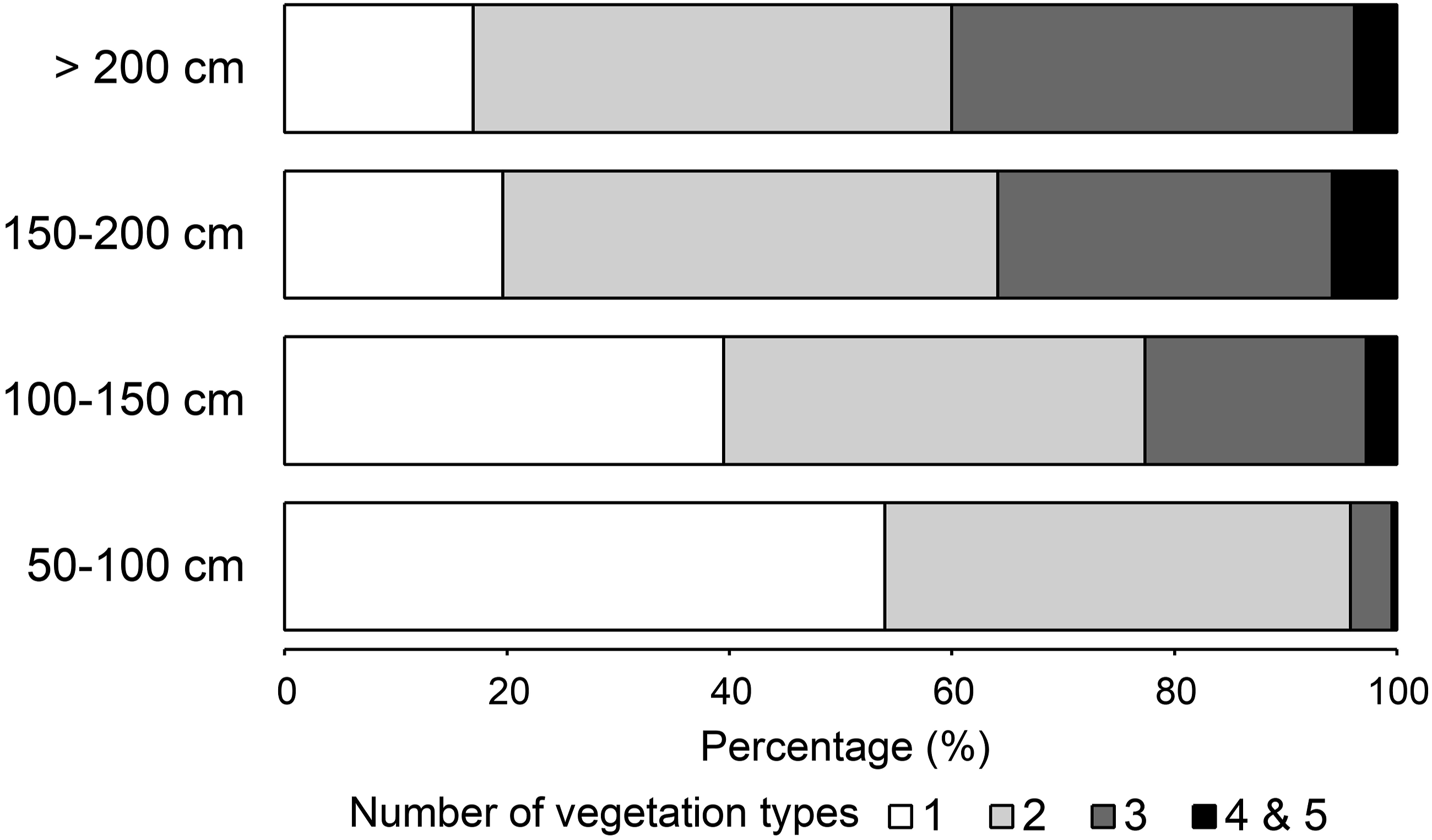
Landslides have received significant attention as an important natural disturbance that maintains biodiversity, but most previous studies have focused on the early stages of succession during years or decades in sites or small watersheds. The present study aimed to determine what regional drivers influence long-term ecological succession in large, ancient landslide scarps across a mountainous region in Japan. A landscape-level analysis of 993 landslide scarps using GIS revealed that climatic factors, especially snowfall, are important regional drivers of vegetation development on landslide head scarps in the region. While vegetation has developed on ancient landslide scarps, not all of them have returned to their pre-landslide vegetation state even though hundreds or thousands of years may have passed. The relationship between the number of vegetation types and maximum snow depth shows that where the maximum snow depth is less than 100 cm, more than 50% of the landslide scarps are covered by one type of vegetation, and the percentage of scarps covered by one type of vegetation decreases with increasing snow cover. The deeper the snow, the more vegetation types tend to develop on the landslide scarps. Since forest vegetation cannot develop due to heavy snow, meadows, grasslands, and shrublands are found on the scarps. It is concluded that the combined effects of both landslide-caused disturbances and climatic factors are creating regional diversity in vegetation types.
Introduction
Landslides have negative impacts on biodiversity, such as the destruction of vegetation and soil, as well as the introduction of non-native species (Alimohammadlou et al., 2013; Gomes et al., 2020). On the other hand, landslides have received significant attention as an important natural disturbance that contributes to maintain biodiversity (Alexandrowicz and Margielewski, 2010; Geertsema and Pojar, 2007). In recent years, numerous studies have been conducted to examine landslides from both of these perspectives.
Species- and community-level studies of vegetation succession in landslide areas have been conducted as field-based studies (e.g., Guariguata, 1990; Nakashizuka et al.,1993; Myster and Walker, 1997; Shiels et al., 2008; Velázquez and Gómez-Sal, 2008; Walker et al., 2013), while community- and landscape-level studies have been conducted using remote sensing (e.g., Jiao et al., 2014; Lin et al., 2008, 2023; Saito et al., 2022; Verdonen et al., 2020; Yang et al., 2018). Vegetation succession in landslide areas is affected by both abiotic and biotic factors at different levels of hierarchy. That is, the major factors driving succession are perceived hierarchically and include regional conditions (climate and geology), local conditions (topography, soil, and species pools, and disturbance regimes), and micro-conditions within a landslide area (biological legacies and inputs/outputs of nutrient and carbon) (Walker and Shiels, 2012).
Most of these previous studies mentioned in the preceding paragraphs have focused on the early stages of succession, and many of them have targeted vegetation changes in the years or decades following a landslide occurrence. However, succession can take longer in landslide areas, and cases of long-term effects of disturbance have been reported. A study of landslide areas on Hawai’i Island suggests that vegetation may require more than 124 years to reach pre-disturbance levels (Restrepo et al., 2003). Mountain fens in Poland at sites more than 200 years after landslide occurrence appear to have not completed recovery of their plant communities (Nicia et al., 2020). A study conducted in Russian high-latitude tundra vegetation areas where decades to millennia have passed since landslides occurred indicates that it takes several thousand years for the vegetation to develop sub-climax and especially climax communities.
It is also possible that landslides create new environments and may not necessarily result in the regeneration of pre-landslide vegetation. It has been suggested that on a volcanic island in Hawai’i, the removal of volcanic ash-derived soils by landslides may have significantly altered the successional trajectory and thereby irreversibly altered the ecosystem (Restrepo et al., 2003). In the mountains of Japan, several mires and ponds where aquatic plants grow are found in ancient landslide areas, probably because landslides have altered the landforms and hydrology (Sasaki and Sugai, 2015; Takaoka, 2015, 2019). Some studies have conducted pollen analysis of samples obtained from such wetlands to identify vegetation changes in landslide areas over the last several thousand years (Igarashi and Takahashi, 1985; Takahashi and Igarashi, 1986; Pánek et al., 2010; Sasaki and Sugai, 2018). Studies with such long-term perspectives, as well as studies on scales of years to decades, are important to understanding the effects of landslides on the formation of local flora and the evolution of vegetation landscapes.
Another aspect that is lacking in the study of vegetation succession in landslide areas is a broad-scale perspective. While most of the previous studies on the initial stages of succession, which are mentioned earlier, have often focused on individual landslide areas or on small watersheds containing several landslides, GIS-based analysis at a broad scale encompassing multiple watersheds is also needed. That is, studies at the landscape level (or regional level) rather than at the community level are required. Such studies can reveal the role of climate and geology as regional drivers of succession (Myster et al., 1997; Takaoka, 2019).
The Japanese archipelago is located in a tectonically active and humid region. The landslide maps published by the National Research Institute for Earth Science and Disaster Prevention (NIED) show that numerous old landslide landforms occupy large areas of mountain slopes in Japan (http://www.j-shis.bosai.go.jp/map/). Most of the mapped landslides appear to be quite old, occurring more than a hundred years ago. In the present study, the effects of landslides on vegetation were examined at the landscape level, targeting scarps caused by large ancient landslides distributed over a large area. It has been reported that vegetation succession on landslide scarps differs from that in landslide bodies (i.e., landslide deposits) (Miles and Swanson, 1986; Neto et al., 2017; Lopes et al., 2020). Compared to landslide bodies that form a mosaic of micro-landforms such as small hills, depressions, trenches, and block fields (Alexandrowicz and Margielewski 2010), the topographical and environmental conditions in landslide scarps are less complex. Moreover, soil and biological legacies (organisms that survive a landslide disturbance) are less likely to remain on scarps (Walker et al. 2009; Lopes et al., 2020). This facilitates the examination of the effects of regional and local conditions such as climate and geology.
Study area
The survey was conducted in a 1,421 km2 region of the Hida Mountains in central Japan which covers a variety of climatic conditions and vegetation types. The survey area was defined as the range above 1,000 m, but certain parts in the southern and southwestern areas were delineated by rivers (Figure 1(a)). Study area a, distribution of studied landslide scarps displayed on a shade relief map based on a 10 m digital elevation model provided by the Geospatial Information Authority of Japan. The centroid of each scarp polygon is shown; b, 30-year average values (1981–2010) of maximum snow depths obtained from the Mesh Climate Data 2010 dataset (Japan Meteorological Agency 2012); c, landslide bodies based on the landslide map published by the National Research Institute for Earth Science and Disaster Prevention (2013).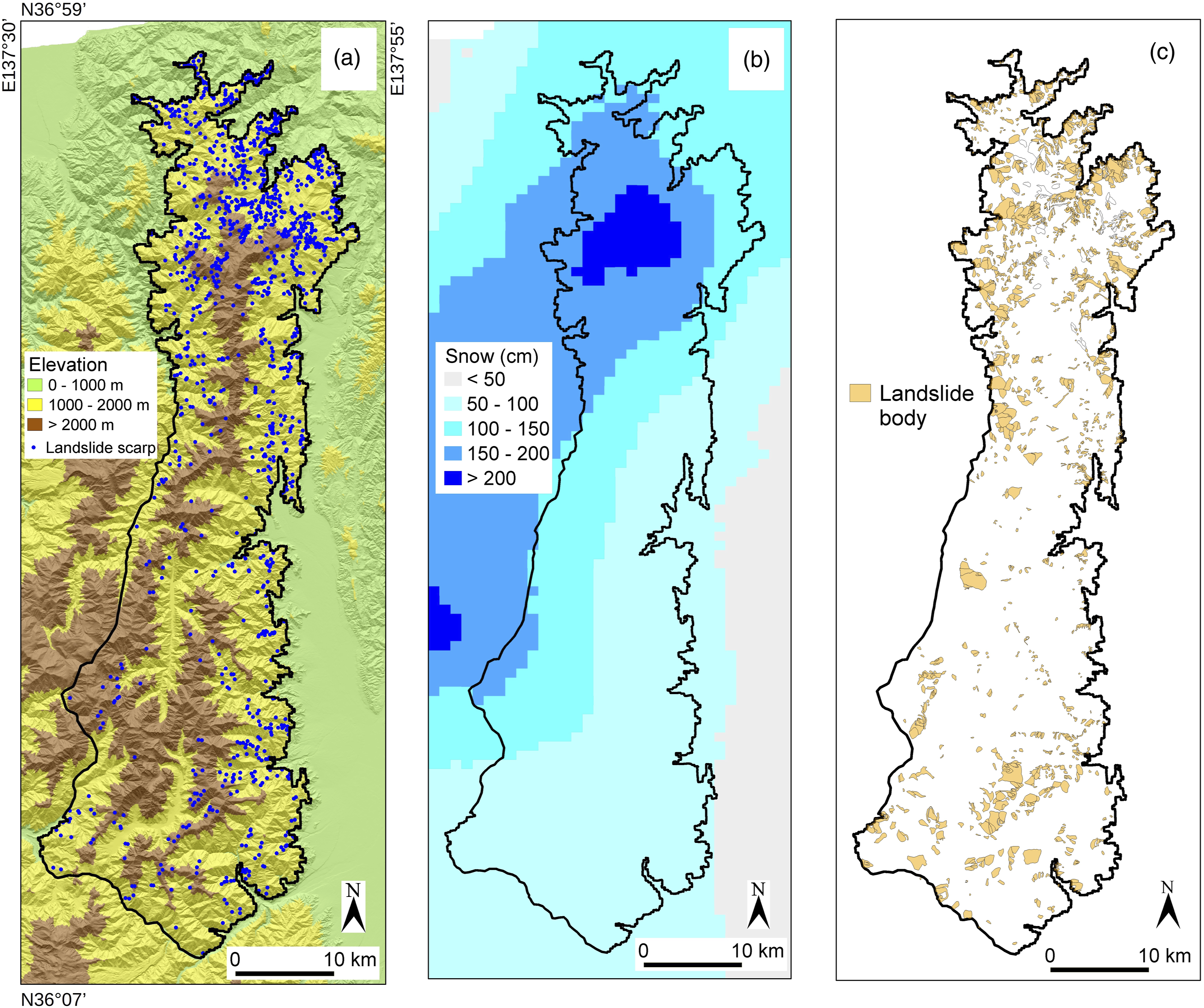
According to Mesh Climate Data 2010 (Japan Meteorological Agency, 2012), average summer temperatures (July to September) range from 9.7°C (2,603 m a.s.l.) to 20.4°C (1,094 m a.s.l.). In the snowiest parts of the study region, the average maximum annual snow depth exceeds 200 cm. Snowfall levels decrease toward the south (Figure 1(b)).
The major vegetation zones are (1) the montane forest zone (ca. 700−1, 600 m a.s.l.) dominated by deciduous broad-leaved trees including Fagus crenata, Quercus crispula, and Tilia japonica, (2) the subalpine forest zone (ca. 1,600–2,500 m a.s.l.) dominated by Abies mariesii, Abies veitchii, Tsuga diversifolia, and Betula ermanii, and (3) the alpine zone, mainly composed of Pinus pumila shrublands and alpine meadows, which occurs in the area above the forest limit. The forest limit is located at approximately 2,500 m a.s.l.; although in the north of the study region which receives heavy snowfall, the forest limit drops to 800–1,000 m a.s.l. (Gansert, 2004). B. ermanii forests form in the topmost parts of the subalpine forest zone in some areas (Okitsu, 1991).
Numerous large landslides have been observed in this region. (Figure 1(c)). The landslide map published by NIED is a 1:50,000 scale map of landslide landforms obtained from 1:40,000 scale monochrome aerial photographs taken in the 1970s. These photographs were interpreted using a stereoscope with 4× magnification. The mapping process involved identifying the upper edge lines of the landslide head scarps and contour lines of landslide bodies, which are referred to as “moved or moving masses” by NIED. The mapping focused on large landslides, specifically those that were at least 150 m wide. In total, the study region contained 1,703 landslide bodies, and these bodies covered approximately 13.9% of the study region.
NIED did not map a large number of new landslides with small areas in the region. Instead, most of the landslides mapped appear to be quite old and can be considered ancient landslides. In most cases, scarps are covered by vegetation, and in many instances, the moved mass in front of the scarp has been incised by stream channels. NIED classifies landslide head scarps by the degree of erosion: those with a partially missing scarp top due to erosion, those with scarp tops eroded by multiple valleys, and those with scarp tops that are entirely rounded due to erosion. However, the chronological age of these scarps is unknown. Based on the geomorphological features, the relative age class (McCalpin, 1984) of most of the landslides is Inactive Young (100–5,000 years) or Inactive Mature (5,000–10,000 years). Radiocarbon ages that were obtained for some of the mapped landslide areas in and around the study region range from 1,383 to 8,916 years (Kariya et al., 2013). The studied landslides also include those that were recorded in historical documents such as one occurring in the Sodegatani watershed in July 1889 and another in the Himekawa watershed in August 1911.
Methods
Classification of landform and vegetation
The target landforms for vegetation analyses were landslide head scarps. Since landslide scarps are not mapped as polygons by NIED, the polygons of the scarps were mapped specifically for analysis in the present study (Figure 1(a)). NIED’s GIS-based landslide map includes the upper edges of landslide head scarps as a line. Based on the line data, the slopes considered to be scarps were delineated as polygons using GIS (TNTmips, MicroImages, Inc.). The extent of the scarps was determined by stereoscopic interpretation of aerial photos taken by the Geospatial Information Authority of Japan (GSI) in 2000–2006 and interpretation of a shaded relief map produced by GSI with 5 m- and 10 m-grid digital elevation models (DEMs). If there was a slope at the bottom of the scarp that was difficult to distinguish from non-scarp terrain, it was excluded from the scarp polygons. Then, the vegetation in the landslide-scarp polygons was classified by stereoscopic interpretation of GSI aerial photos taken in 2000–2016.
A physiognomic classification of vegetation was performed in this study because it is useful to describe the vegetation of large area. Within each of the scarp polygons, vegetation covering 200 m2 or more was classified into seven types. The vegetation classification was conducted by stereoscopic aerial photo interpretation, based on the color and texture of the image, relative vegetation height, and tree canopy size. The types included broad-leaved forest, coniferous forest, shrubland, Sasa grassland, meadow, rubble field, and artificial vegetation including plantation forests. Sasa grasslands are dominated by dwarf bamboo, and Sasa species include Sasa senanensis and Sasa kurilensis. The seven types are representative of the vegetation physiognomic types in the region. The number of types in each landslide-scarp polygons is referred to as vegetation richness.
Vegetation comprising trees approximately 5 m or taller was classified as a forest. Coniferous trees were identified as those with conical or columnar canopies, and coniferous forests were defined as those in which these trees occupied more than 50% of the forest canopy layer. The color of the canopy also aids in distinguishing between the two. Broad-leaved trees are deciduous, while conifers are evergreen, except for larch trees. As a result, the canopy of conifers is darker than that of broad-leaved trees.
Shrubland was defined as vegetation with a height of approximately 5 m or less and a small canopy diameter. While shrubland is often composed of broad-leaved trees, coniferous shrubland exists in certain parts of the area. However, they were grouped into a single class because it can be challenging to distinguish between them, except when they are deciduous. Both forests and shrublands were classified as planted forests when the canopy was arranged in a linear or grid pattern.
Vegetation composed of non-tree species was classified into Sasa grassland, meadow, and rubble field. Among these, Sasa grassland and meadow are characterized by low plant height, and among them, those with a bright tone and coarse texture are considered as Sasa grassland. Since Sasa species is evergreen, meadow could be distinguished from Sasa grassland based on color tones in seasons other than summer. Rubble field is where the vegetation cover is less than 50%. This includes many areas where no vegetation is found at all, which appear light gray in aerial photographs. This class also includes areas where bedrock is exposed.
In order to compare the vegetation in landslide scarps with that in areas not affected by a landslide, I also observed the vegetation that forms in areas outside landslide scarps. The dominant vegetation on the slopes adjacent to each landslide scarps was classified by aerial-photo interpretation in the area north of 36.7 N latitude, where various vegetation types are mixed.
Spatial analysis
A Random Forest analysis (Breiman, 2001) was conducted to identify the relative importance of environmental factors influencing vegetation richness on landslide scarps. In the Random Forest model, approximately two-thirds of the data was used for classification through bootstrap sampling, while the remaining one-third of the data, referred to as out-of-bag (OOB), was used to estimate the overall error of the model. For each model, a confusion matrix was obtained, and false positive and false negative rates were calculated.
In general, in Random Forest analysis, the importance of each explanatory variable is calculated based on the amount of impurity reduction in the branches of the decision tree in the model, and in the present study, the Gini coefficient reduction was calculated. Variables with larger values of this measure are considered to have a greater influence on the model's predictions. Random Forest analysis was conducted not only to identify variables that have a significant impact on the abundance of vegetation types but also to identify variables that contribute significantly to the occurrence of each vegetation type.
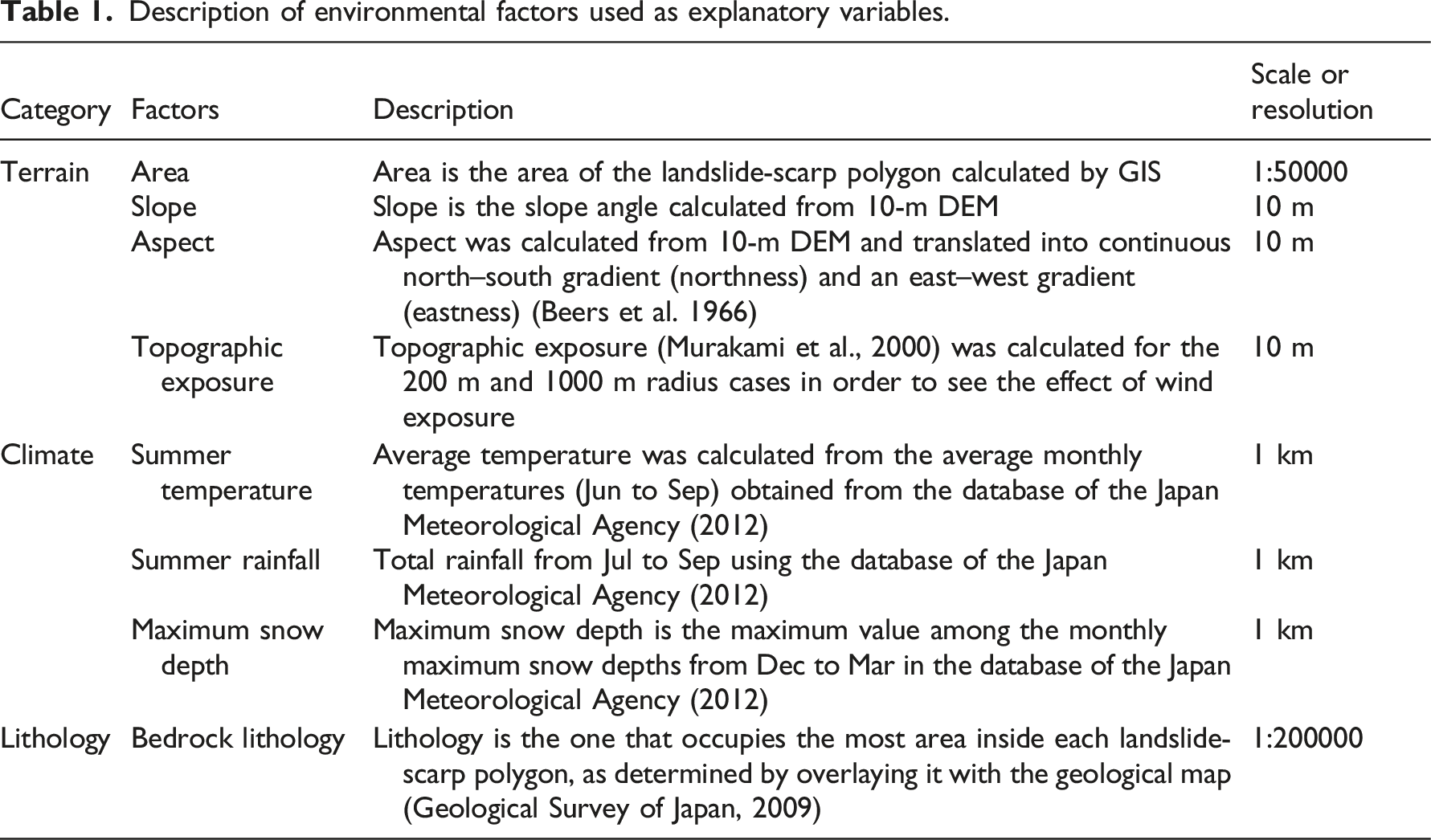
Description of environmental factors used as explanatory variables.
A 10 m DEM provided by the GSI was used to produce maps of slopes, aspects, and topographic exposure using GIS. The aspects were translated into continuous north–south gradients (northness) and an east–west gradients (eastness) using the following equations: northness = cosine (aspect); eastness = sine (aspect). The topographic exposure was defined as the total value of the horizontal angle within view from a given point to a given distance (Murakami et al., 2000). This was calculated for the 200 m and 1,000 m radius cases. The terrain variables were calculated as the means of each of the 10 × 10 m cells making up each landslide-scarp polygon.
The 30-year average values (1981–2010) of the climate variables were obtained from the Mesh Climate Data 2010 dataset (Japan Meteorological Agency, 2012). The average summer temperature (July to September), total summer rainfall (July to September), and maximum snow depth were used as climate variables for each polygon.
The lithology of each polygon was defined as the most dominant lithology in that polygon according to a geological map of 1:200,000 scale (Geological Survey of Japan, 2009). The lithology data were transformed into a dummy variable.
The presence or absence of each vegetation type in each landslide-scar polygon was used as the response variable. The number of vegetation types within each polygon and the presence or absence of forest vegetation (coniferous and broad-leaved forests combined) were also used as response variables. The number of vegetation types within each polygon was binarized using a threshold value: the presence or absence of vegetation consisting of three or more types was used as the response variable.
Number of polygons for the response variables used in the Random Forest analysis.
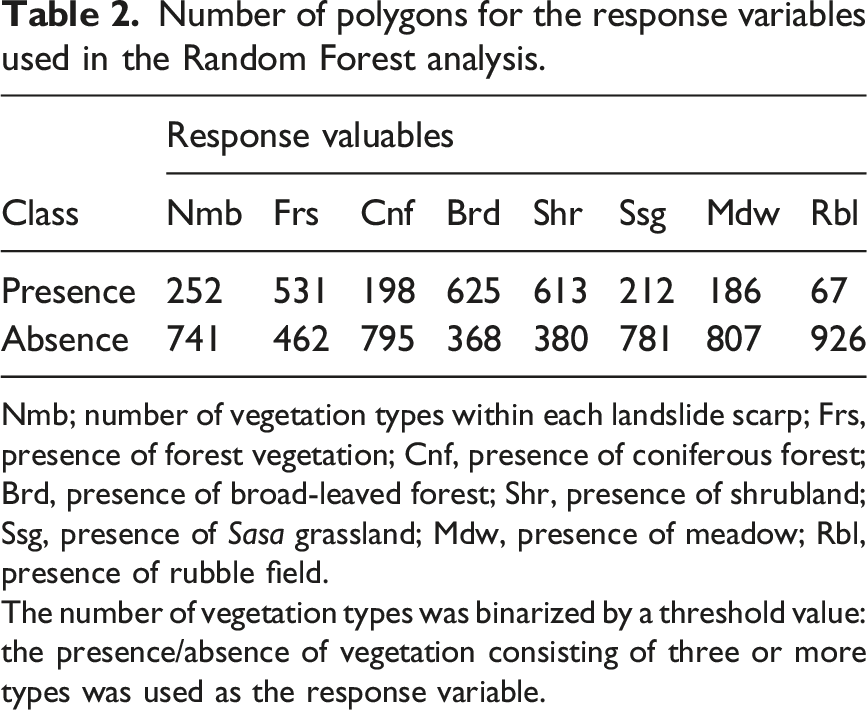
Nmb; number of vegetation types within each landslide scarp; Frs, presence of forest vegetation; Cnf, presence of coniferous forest; Brd, presence of broad-leaved forest; Shr, presence of shrubland; Ssg, presence of Sasa grassland; Mdw, presence of meadow; Rbl, presence of rubble field.
The number of vegetation types was binarized by a threshold value: the presence/absence of vegetation consisting of three or more types was used as the response variable.
The Random Forest models were simulated using the randomForest package (Liaw and Wiener, 2002) in R (ver. 3.3.2; R Core Team, 2016). The datasets were balanced using the SMOTE algorithm from the DMwR package in R (Torgo, 2010). As part of the Random Forest procedure, 500 classification trees were built for each dataset.
Results
Distribution of vegetation types
Landslide head scarps were covered with one to five vegetation types (Figure 2(a)), and areas covered with three or more vegetation types were common in the northern part of the study region where the distribution overlapped with areas with large maximum snow depths. The relationship between the number of vegetation types and maximum snow depth indicated that where the maximum snow depth was less than 100 cm, more than 50% of the scarps were covered by a single type of vegetation and that the percentage of scarps covered by a single vegetation type decreased with increasing snow cover (Figure 3). The percentage of scarps covered by three or more types of vegetation tended to be higher at greater snow depths. Distribution of number of vegetation types (a), the most dominant vegetation (b), and maximum snow depth (c). The centroids of the scarp polygons are plotted. In panel b, the most dominant vegetation was defined as the vegetation that occupies the largest area in each polygon. In panel c, maximum snow depth is the maximum value among the monthly maximum snow depths from December to March. Difference in the diversity of vegetation with respect to snow-depth class.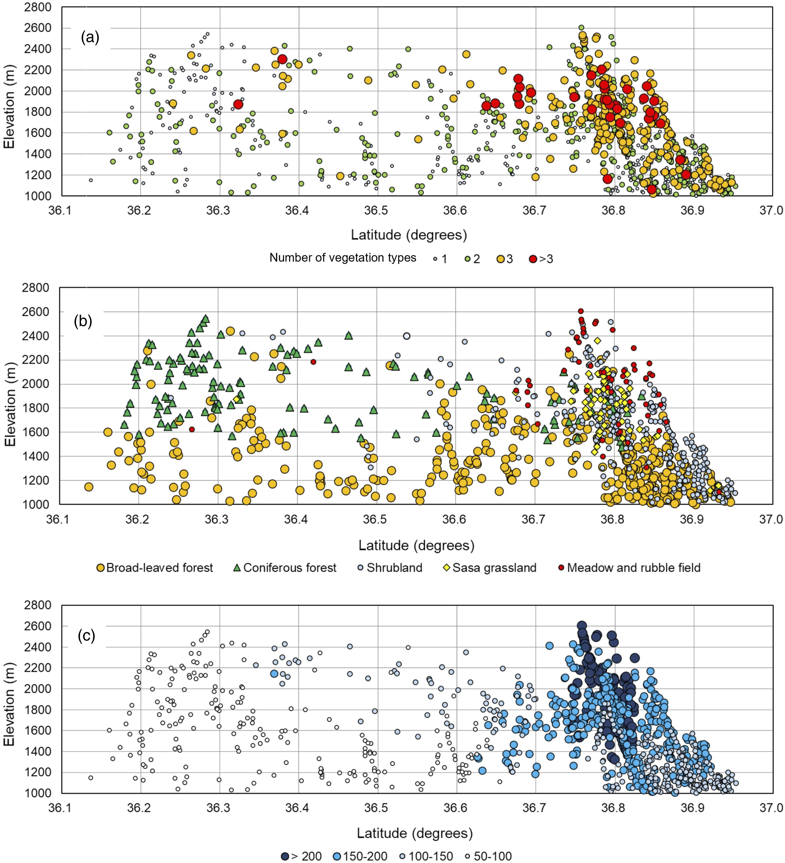
Coniferous forests dominated landslide scarps at elevations above approximately 1,600 m, and broad-leaved forests dominated mainly at lower elevations (Figure 2(b)). Broad-leaved forests occurred in some areas above approximately 1,600 m elevation and were dominated by B. ermanii, which is generally found in subalpine zone evergreen coniferous forests. Shrublands at higher elevations were usually dominated by P. pumila, but in areas with heavy snow cover, shrublands of B. ermanii and A. mariesii were also seen.
Number of landslide scarps and adjacent slopes by vegetation type.
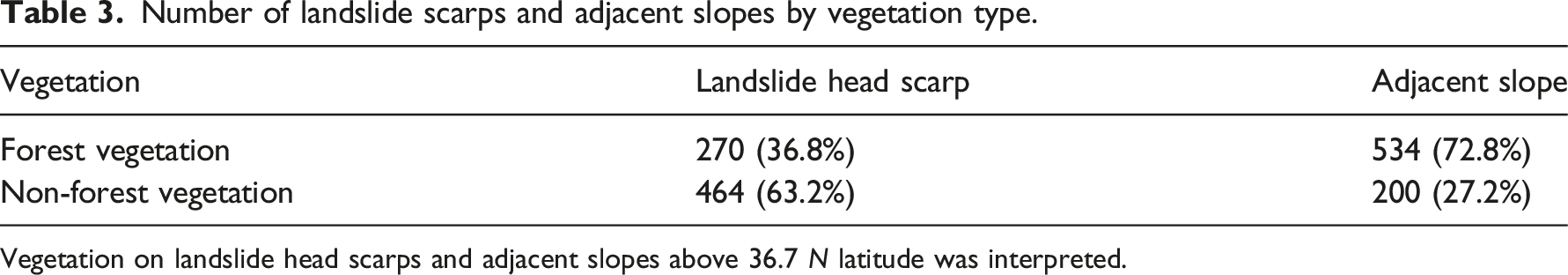
Vegetation on landslide head scarps and adjacent slopes above 36.7 N latitude was interpreted.
Relative importance of variables
The relationship between climate-related variables and the vegetation types used as response variables showed that climatic conditions were associated with distinctions between forest and non-forest vegetation (Figure 4). Non-forest vegetation types, such as shrubland, Sasa grassland, meadow, and rubble field, were observed in areas characterized by lower mean summer temperatures and greater maximum snow depths than forest vegetation. Box-and-whisker plots of the seven response variables. Bar line within the box represents median number, boxes represent first- and third-quartile ranges (25th and 75th percentiles), and range bars show maximum and minimum of non-outlier numbers. Cross marks indicate the mean. Abbreviations of response variables are the same as in Table 2. The "p" in parentheses attached to the abbreviation represents presence, and "a" represents absence. Welch's t test was performed; **p<.001; *p<.01; n.s., not significant.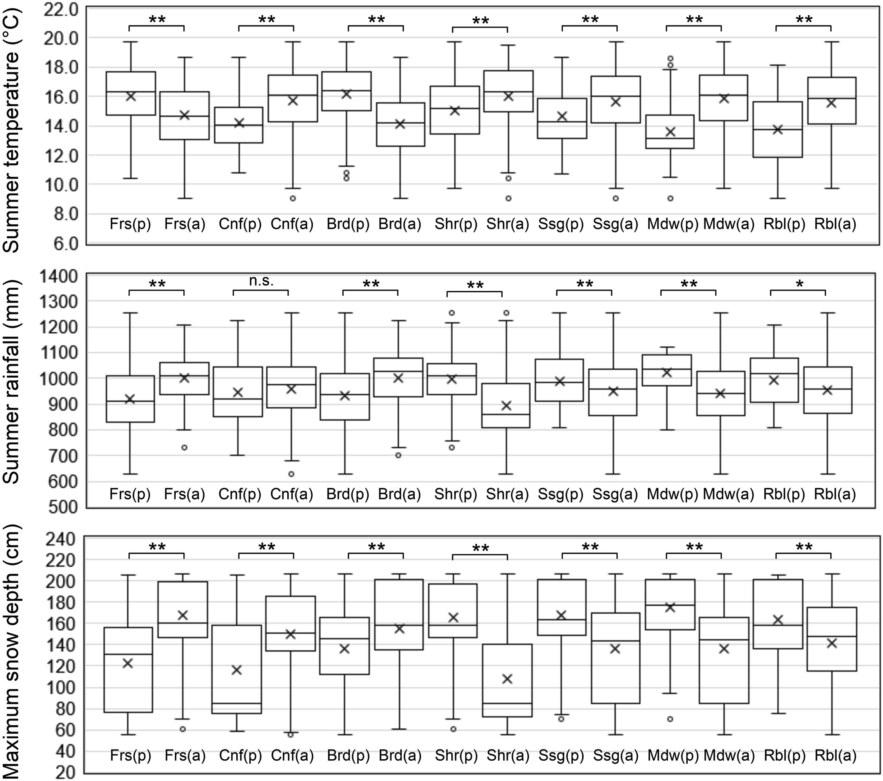
Variable importance determined by Random Forest analysis using mean decrease in Gini coefficient.
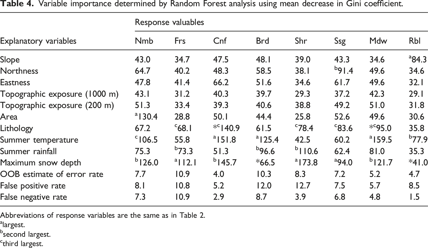
Abbreviations of response variables are the same as in Table 2.
alargest.
bsecond largest.
cthird largest.
Summer temperature values were large for the response variables, the presence of coniferous forest (Cnf), and the presence of broad-leaved forest (Brd). That is, coniferous rather than broad-leaved forests occurred on landslide scarps at cooler elevations (Figure 2(b)). The values of temperature were also large for the response variables meadow presence (Mdw) and rubble-field presence (Rbl). Both of these vegetation types were observed more frequently at cooler elevations. The value of the slope was also large for the presence of rubble fields, which dominated on steep slopes. Northness was large for the response variable Sasa-grassland presence (Ssg), with Sasa grasslands being prevalent on southeast-facing slopes.
The mean decrease in the Gini coefficient for bedrock lithology was the third highest for the five response variables (Frs, Cnf, Shr, Ssg, and Mdw) and the fourth highest for the two response variables (Brd and Rbl) as shown in Table 4.
Discussion
Factors creating vegetation richness on landslide scarps
According to the results of Random Forest analysis, there are many response variables for which the maximum snow depth has the first or second largest effect. This suggests that a heavy snowfall environment is closely related to the development of vegetation on the landslide head scarps in this region. Snow causes mechanical and physiological damage to trees, and it has been shown that heavy snowfall strongly affects the establishment of vegetation in mountainous areas of Japan (Matsuura and Suzuki, 2013; Shidei, 1979; Wardle, 1977). The results of the present study indicate that the vegetation on landslide scarps is also affected by heavy snowfall environments. Because snow cornices (overhanging snow) often form at the upper edge of landslide scarps, these scarps are one of the avalanche-prone areas in mountainous regions (Daimaru et al., 2000). Additionally, landslide scarps are generally steep slopes; thus, snow glide and snow creep greatly influence the establishment of vegetation on these steep slopes (Daimaru and Taoda, 2004).
The results of Random Forest analysis indicated that the area of landslide scarps is the primary explanatory variable for the number of vegetation types found inside the scarps, probably because larger scarps can contain more diverse environments such as elevation, slope, stability, lithology, soil depth, and adjacent vegetation. However, the fact that the second explanatory variable for the number of vegetation types is the maximum snow depth and that the mean decrease in the Gini coefficient of the maximum snow depth is exceedingly high compared to the other explanatory variables for the response variables of forest presence and shrubland presence suggests that snow fosters vegetation richness through its adverse effects on forest development, such as snow creep and glide, avalanches, and shortened growing seasons (Daimaru and Taoda, 2004; Kajimoto et al., 2004; Takaoka, 1999).
Where forests fail to form, shrublands, Sasa grasslands, meadows, and rubble fields are established. Shrublands are formed by broad-leaved trees with creeping trunks that can withstand the pressure of snow (Onodera et al., 1995; Kikuchi, 1981). Sasa grasslands form on steep slopes of 30° or more on slopes with more snow cover (Takaoka, 1999). Where snow-free periods are short or soils are moistened by melting snow water, meadows are established instead of shrublands and Sasa grasslands (Kudo et al., 2011). Where snow-induced erosion occurs, bare lands are formed (Aiura, 2002).
The Hida Mountains is one of the snowiest regions in the world (Takahashi, 2021), and snow is particularly heavy in its northern region, and less so in its southern region (Figure 2(c)). This is likely the reason why diverse vegetation development is more evident in the northern part of the region than in the southern part (Figure 2(a)). The differences in vegetation between the northern and southern parts of the Hida Mountains have been noted in the previous studies. In the north, heavy snowfalls form areas where evergreen coniferous forests are replaced by broad-leaved forests dominated by B. ermanii and shrublands (Ozeki, 2001; Gansert, 2004). The increase in snow depth creates areas with higher snow pressure and delayed snowmelt, which contribute to a more diverse range of non-forest vegetation in the scarps in the northern region. The findings of the present study suggest that the way landslides affect vegetation is not uniform within a region and depends on regional differences in climate.
The results of the vegetation classification of the areas adjacent to landslide scarps indicate that some slopes were not forested even adjacent to scarps in the northern region (Table 3). This means that snow is affecting vegetation even on slopes that NIED did not identify as landslide scarps and bodies. However, the formation of non-forested vegetation is particularly apparent on the landslide scarps. This is probably due to the relatively steep slopes of the scarps, where avalanches and snow glides occur and the effect of snow on vegetation is stronger. The formation of landslide scarps can be considered to activate potential snow-related processes in the region. Certain slopes not classified as landslide areas by NIED include steep slopes, which could potentially be scarps resulting from ancient landslides. This may be reflected in the results presented in Table 3.
The value of summer temperature as an explanatory variable is significant for the presence of both coniferous forests and broad-leaved forests (Table 4). Moreover, scarps with broad-leaved forests exhibit higher temperatures than those with coniferous forests (Figure 4). Since the studied landslides are quite old, climax forest vegetation was likely established by ecological succession in some parts of the study region. In such places, the dominant species likely separated into subalpine conifers and montane broad-leaved trees, depending on elevation which in turn drives summer temperatures (Figure 2(b)).
Long-term succession of vegetation on landslide scarps
Landslide head scarps are usually steep and infertile, as most soil and organic matter have been removed (Lopes et al., 2020; Myster and Fernández, 1995). Additionally, the remaining soils are unstable and susceptible to erosion, and vegetation recovery is unlikely to be easy. However, in the study region, most of the landslide scarps were covered by some type of vegetation. Since the landslides studied are quite old, it is possible that the slopes have stabilized and soils have begun to develop in some areas, thus creating an environment in which vegetation can develop.
Although vegetation has developed on the landslide scarps, not all have recovered their pre-landslide vegetation. Some of the scarps in this region have evergreen coniferous forests in the subalpine zone and deciduous broad-leaved forests in the montane zone. These are considered cases where the pre-landslide vegetation has been reestablished through ecological succession. However, non-forest vegetation including shrublands, Sasa grasslands, meadows, and rubble fields is also present at the elevations of the forest vegetation zones. This may be due to the formation of steeper slopes than before the landslide occurred, thereby increasing the effects of snow which prevent the development of forests.
Myster et al. (1997) compared vegetation at sites decades after a landslide and found that age, elevation, slope aspect, and bedrock lithology were important factors in determining the complexity of vegetation structure. Although vegetation changes through ecological succession, factors that drive succession were shown to be important not only for the time since the landslide occurred but also for climatic and bedrock conditions. The findings of the present study indicate that climatic factors (snow cover and summer temperatures) are effective regional drivers among ancient landslides as well. The lithology of the substrate was also found to be influential, though not as much as the climatic factors.
On landslide bodies (landslide deposits), more diverse vegetation is established in areas with heavy snowfall (Takaoka, 2019). Wetlands and ponds, which do not form on landslide scarps, form on landslide bodies, so vegetation richness here is even higher than on landslide scarps. The results shown in the present study and by Takaoka (2019) suggest that the process of dissecting mountainous terrain by landslides creates and fosters vegetation richness. Climatic conditions play a major role in the process of creating this diversity and may lead to regional differences in the effects of landslides on vegetation.
Footnotes
Acknowledgments
The author is grateful to Professor Yoshihiko Kariya of Senshu University for his valuable comments during the course of this work. Discussions with members of the Research Group for Natural History in Kamikochi were also fruitful.
Declaration of conflicting interests
The author(s) declared no potential conflicts of interest with respect to the research, authorship, and/or publication of this article.
Funding
The author disclosed receipt of the following financial support for the research, authorship, and/or publication of this article: This work was supported by JSPS KAKENHI Grant Numbers JP23H00727 and JP20H01390.
Data availability statement
Data is available on figshare (![]() ).
).