
Abstract
The overcapacity and overdevelopment of cities have led to various environmental hazards and resource depletion, making it crucial to evaluate the suitability of urban development. This research field provides scientific evidence and policy recommendations to improve land use quality and distribution. However, contemporary studies solely focus on construction land versus non-construction land competition, ignoring potential constraints from agriculture and ecology on parcel development. Using the land use situation of Zhengzhou City, this study comprehensively evaluated urban development suitability through hierarchical analysis, Delphi method, and eight-direction analysis. A multi-attribute overlay was applied with spatial restrictions from ecological protection and agricultural production, combined with urban expansion and development conditions. The results indicated that: (1) Ecological protection was critical for sustainable urban development, and areas like the Yellow River coast, northwest wetland, and southwest woodland were significant for ecological protection. High suitability areas for agricultural production were primarily located within the existing cultivated land. (2) Regarding urban expansion, the southeast of the city center was identified as the most suitable area, mainly covered by dryland. (3) Overall, the unsuitable, basically unsuitable, medium, suitable, and highly suitable areas for urban development covered 244, 921, 3024, 2224, and 944 km2, respectively. (4) The southeast-northwest direction showed prominent spatial characteristics for urban development suitability, while intensive development mode dominated the east-west direction of the city center. These findings provide significant guidance for land development and utilization, optimizing the spatial pattern, and formulating policies in Zhengzhou. Nevertheless, the weight calculation process presents a subjective factor that needs to be addressed in future research. More objective weight calculation results are necessary to achieve a more scientifically rigorous evaluation of urban development suitability.
Keywords
1 Introduction
Rapid urbanization in China is leading to the disorganized spread of urban development, and the spatial conflicts between construction development, ecological land, and basic agricultural land are becoming more acute. Optimizing the urban development pattern and coordinating development while preserving the natural environment have become urgent issues (Huang et al., 2021). Evaluating land suitability is an important basis for optimizing the spatial development pattern of China and improving the location of the main regional functions (Ji et al., 2019). On the basis of the resource and environmental carrying capacity, the evaluation of land suitability for urban development had become an essential tool to alleviate the conflict between construction development and the ecological environment. This is important for delineating the development boundary of cities and towns, protecting urban ecological land and guiding the spatial layout and structure of land development (Fan and Zhao, 2021; Lin et al., 2018).
In the early 20th century, suitability evaluation began to be widely used in land research, and most of the studies were focused on agricultural evaluation. In the 1960s, the classification and grading of arable land and farmland was gradually carried out in Europe and the United States (Yu et al., 2015; Seyedmohammadi et al., 2019). Land suitability evaluation gradually became a standard procedure in urban planning, but the traditional superposition mapping and numerical calculation methods could no longer meet the demand for comprehensive evaluation of multiple factors. In the 1990s, GIS technology allowed breakthroughs in spatial analysis and methods using geographic information science became the main technical means of suitability evaluation, and multi-factor spatial overlays were widely adopted in research (Xie et al., 2020). Subsequently, many studies have carried out in-depth analysis and exploration of evaluation units, and research has shifted from single land use categories such as agricultural land and forest land to comprehensive categories such as tourism land (Jokar et al., 2020), the urban economy (Tong et al., 2018), and marine integration (Berry and BenDor, 2015). Following the wide application of spatial data analysis techniques, evaluation systems were no longer limited to the development conditions of a single space, and the interaction between different spaces has become the main factor influencing land suitability (Jia and Zhessakov, 2021; Liao et al., 2020; Ullah and Mansourian, 2016). In 2018, Chinese government proposed scientifically recognizing spatial pattern analysis and social and economic laws based on the evaluation of resource and environmental carrying capacity and the suitability of land spatial development (“double” evaluation). The system of index for research concentrating on crossing-over and applied studies is constructed which is primarily selected and evaluated by topography and geomorphology (Tang et al., 2022), location advantages (Cheng et al., 2018), transportation conditions (Song et al., 2020), land type (Jiang et al., 2020), hydro-meteorology (Wang et al., 2021), and disaster risk (Flynn et al., 2019). The research scope includes urban clusters (Xing et al., 2019), provincial areas (Dilishati et al., 2019), municipal areas (Wang et al., 2020), and county areas (Li et al., 2021).
At present, the evaluation of urban development suitability is closely correlated with the configuration conditions of construction land. Most studies (Yin et al., 2020; Li et al., 2020b; Weil et al., 2018; Zhao et al., 2021; Lan et al., 2022; Tang et al., 2015) evaluate the suitability of urban development by analyzing the spatial and temporal changes of land use and the single evaluation of resources and environment. The objective demand for urban development often becomes the main factor in the evaluation, and less consideration is given to ecological and agricultural space constraints, resulting in the evaluation results losing the nature and practical significance of control with planning. And previous studies have focused mainly on administrative districts in which the evaluation indexes tended to show their averages of value and their functional orientation and lacking a consideration of competing factors for a particular location of space. In this study, the assignment of indexes based on the land use type demonstrated the spatial form or evolution of various characteristics in geographical space. To enhance the effectiveness of urban development or the performance of comprehensive government administration, which can guide the urban system toward a sustainable development path, spatial element control and land resource management are applied (Wang et al., 2020). As a result, a suitability evaluation is carried out to determine whether a piece of land is suitable for the use intended as well as any restrictions, in order to serve as a guide for future policies involving ecological restoration, agricultural protection, and urban development. The evaluation of urban suitability for different development needs can be aligned with the basic evaluation of three types of territorial units: ecology, agriculture, and urban, which also have certain independence and irreplaceability of territorial spatial functions.
This study took the central urban area of Zhengzhou as the research object, integrated multiple spatial analysis tools, conducted independent evaluation of ecological protection, agricultural production and urban expansion, and created a multi-factor evaluation framework for the suitability of national land space. According to the functional attributes of the three types of space divided into constrained and expansionary factors, the result of the comprehensive evaluation of urban development suitability was obtained through cross-superposition, and the scale of construction suitability and development potential of urban development were revealed on multiple scales. The aim was to provide new ideas for the optimization of the spatial development pattern in China and a scientific basis for the delineation of urban development boundaries and the determination of the main functional areas.
The rest of this paper is structured as follows: Section 2 describes study area overview and raw data sources. Section 3 presents the method used in the article, which consists of indicator systems and mathematical calculations. The results of the study are analyzed in Section 4, including constrained, expansionary and comprehensive evaluation. Section 5 covers the study’s conclusions, discussion of differences, and limitations.
2 Study area and material
2.1 Study area
Zhengzhou City is located in the central north of Henan Province, 112°42′–114°14′ E, 34°16′–34°58′ N (Figure 1 Geographical location and features of the central urban area of Zhengzhou.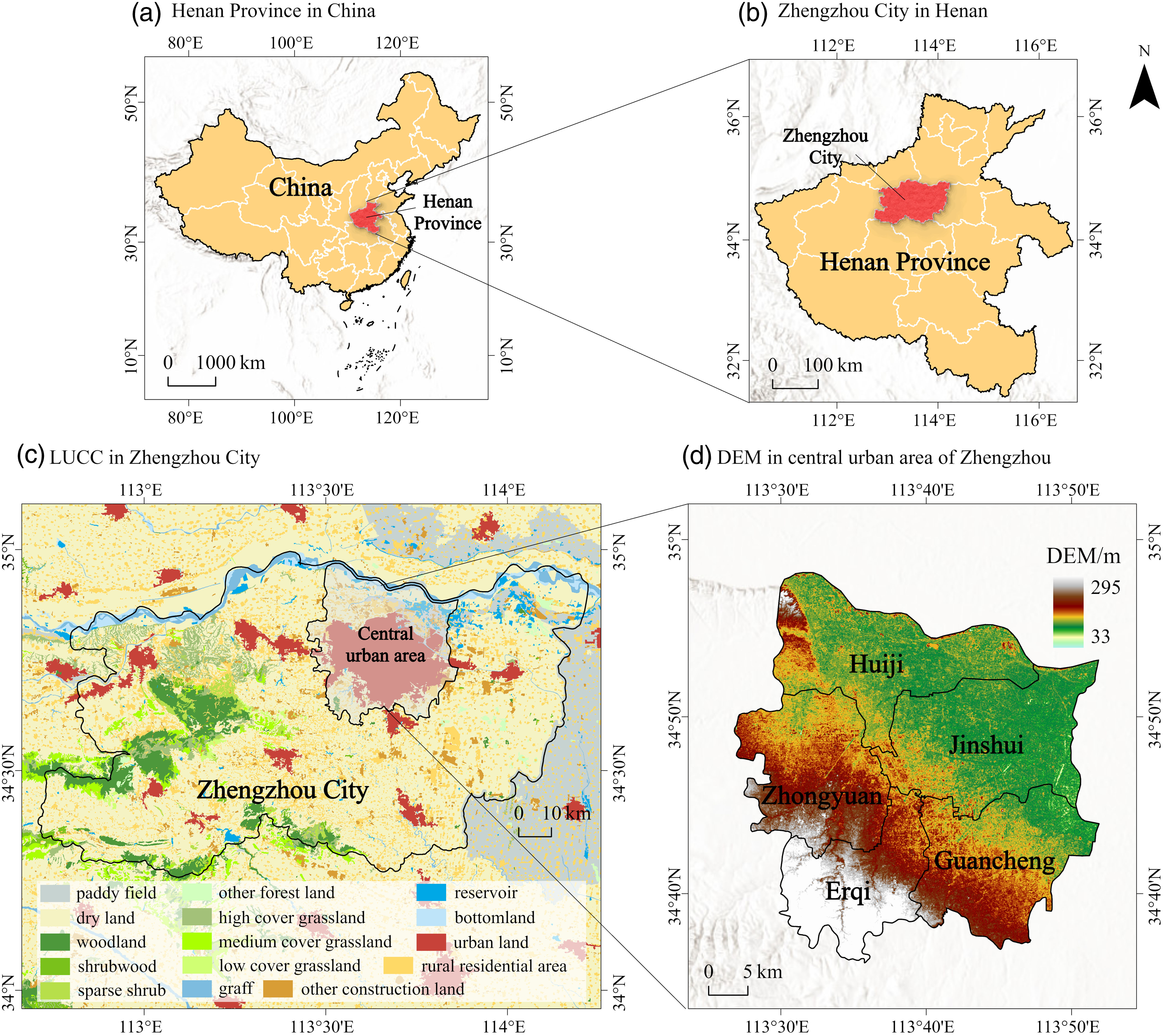
2.2 Data and preprocessing
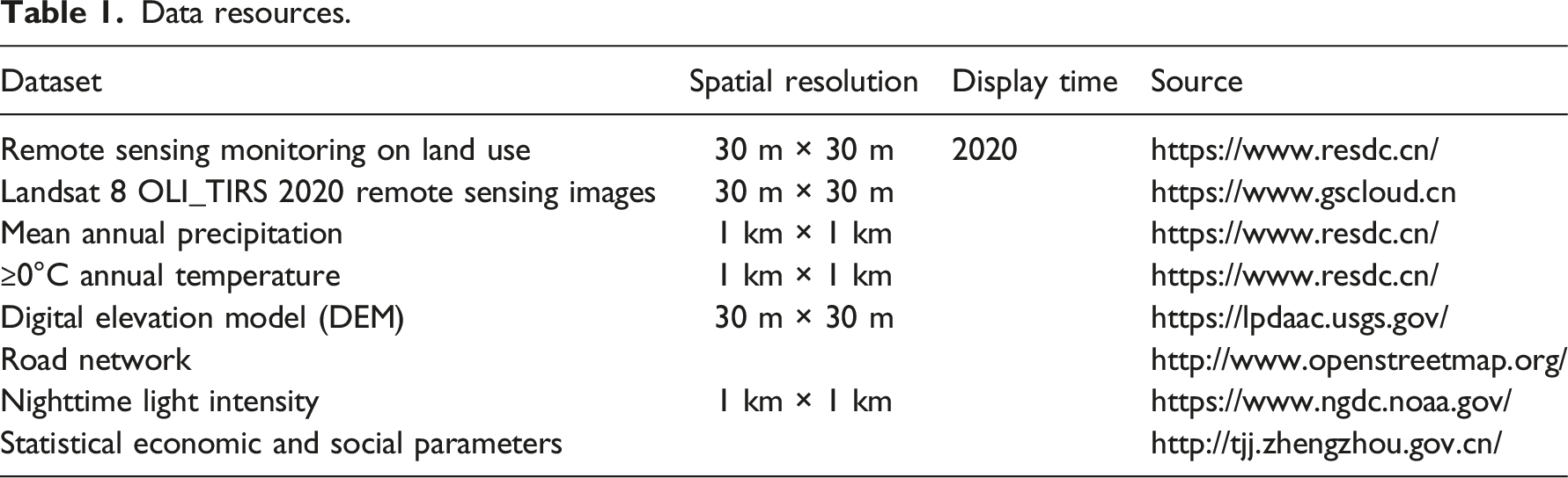
Data resources.
3 Methodology
In this study, ecological protection and agricultural production evaluations were used as resistance factors limiting urban development, and urban expansion evaluations were used as development factors. The spatial overlay results after weighting and grading were used as the basis for a comprehensive urban development suitability evaluation (Figure 2). The weights involved in the evaluation process were obtained using AHP or the Delphi method. Some indicators were slightly reduced in weight value compared with a single evaluation owing to their participation in multiple spatial overlays. A flow chart depicting the analytical process of the research methodology.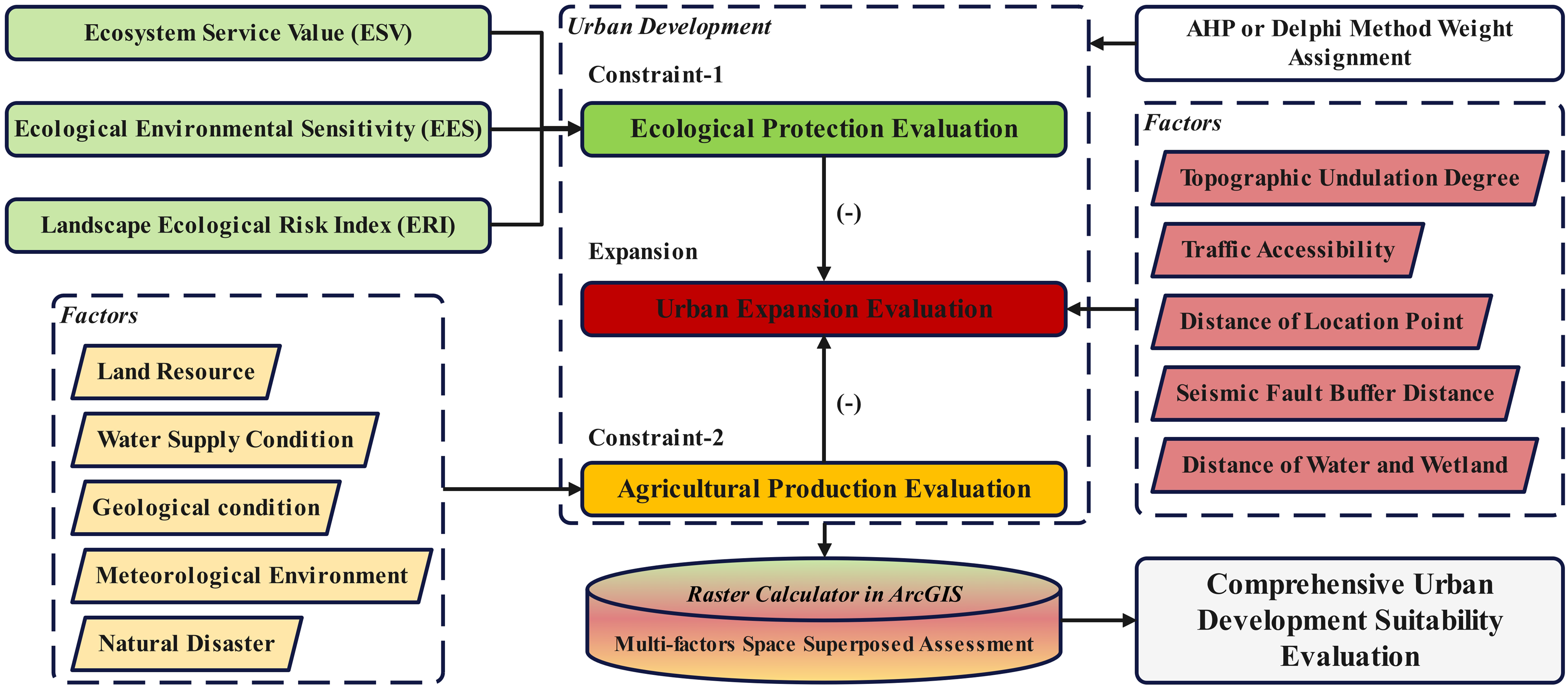
3.1 Ecological protection evaluation
3.1.1 Ecosystem service value (ESV)
Using ESV as an evaluation factor in the urban development process is an effective method to promote local ecological civilization. Referring to other studies (Xie et al., 2003; Xie et al., 2015), eight functions including food production, raw material production, gas regulation, climate regulation, hydrological regulation, soil conservation, waste treatment, and esthetic landscape were selected as evaluation factors. Using the equivalent factor method of ecosystem service value per unit area, the area of each land use type was multiplied with the corresponding ecosystem service function value coefficient, and finally all of them were added to get the total value of ecological services in the study area, where the value coefficients of urban land, rural residential land and other construction land were all assigned to 0. The ESV evaluation results were divided into levels 1–5 according to the natural breakpoint classification method, with a higher value equating to a higher level. The calculation formula was as follows:
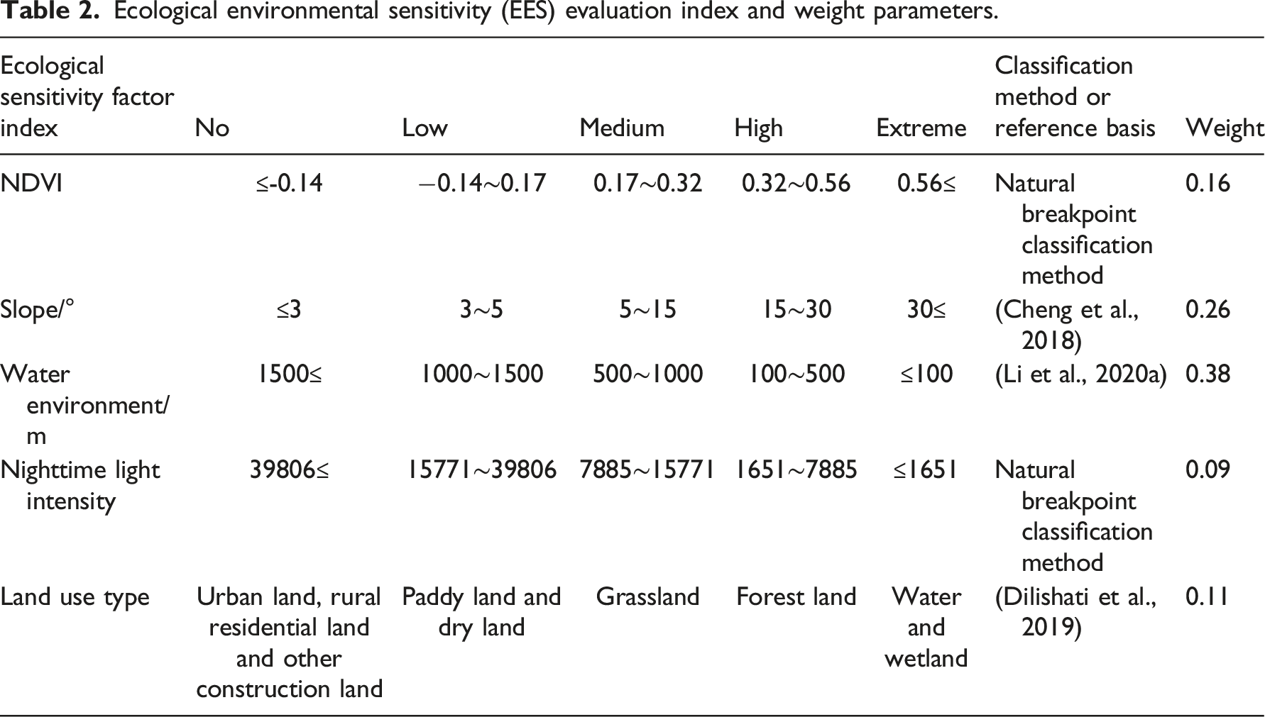
3.1.2 Ecological environmental sensitivity (EES)
Ecological environmental sensitivity (EES) evaluation index and weight parameters.
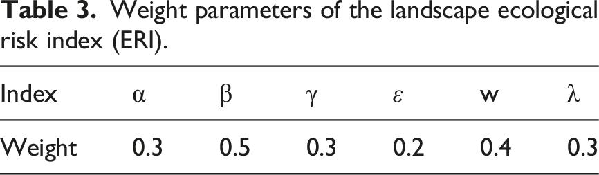
3.1.3 Landscape ecological risk index (ERI)


Weight parameters of the landscape ecological risk index (ERI).
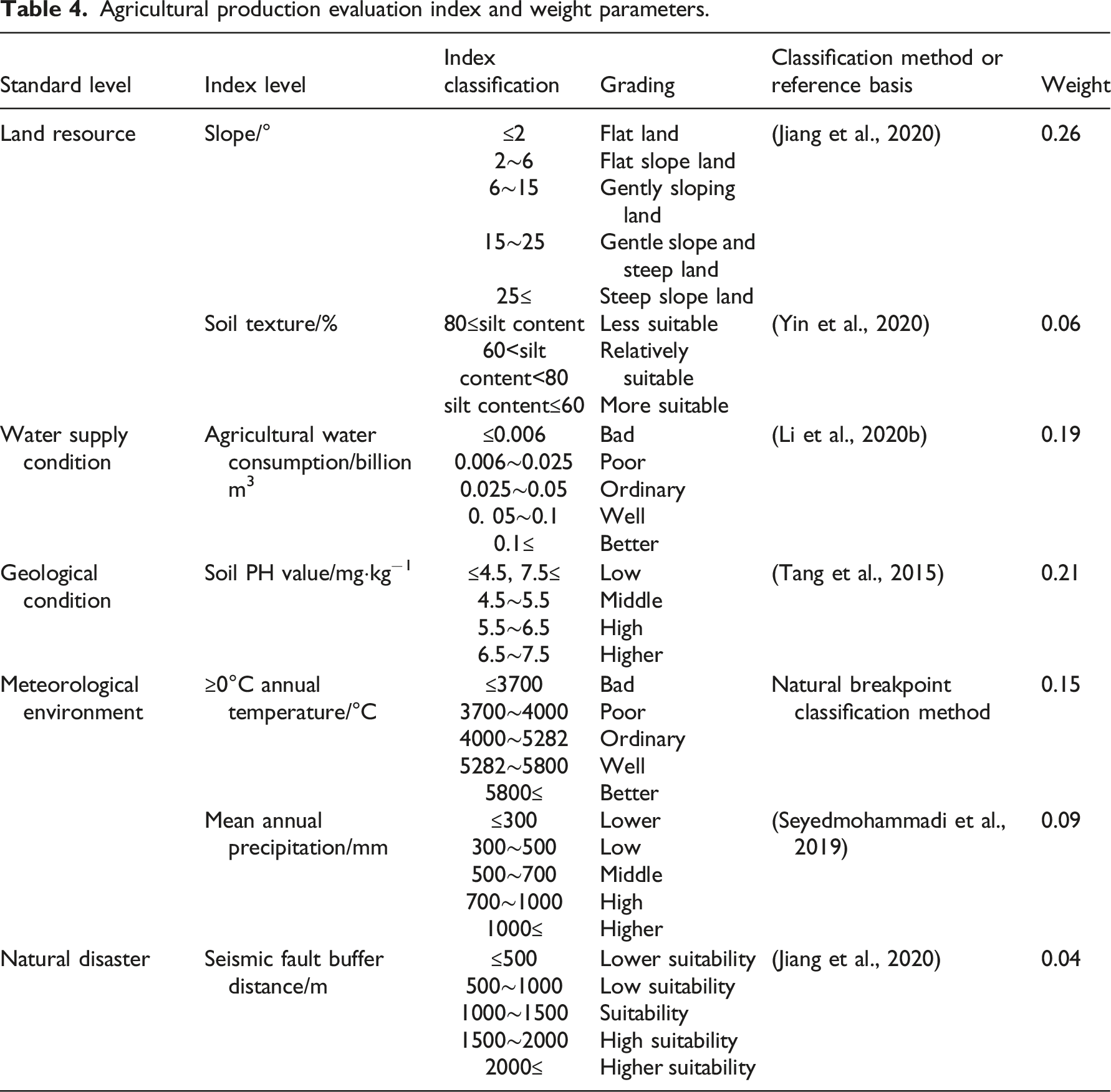
3.2 Agricultural production evaluation
Agricultural production evaluation index and weight parameters.
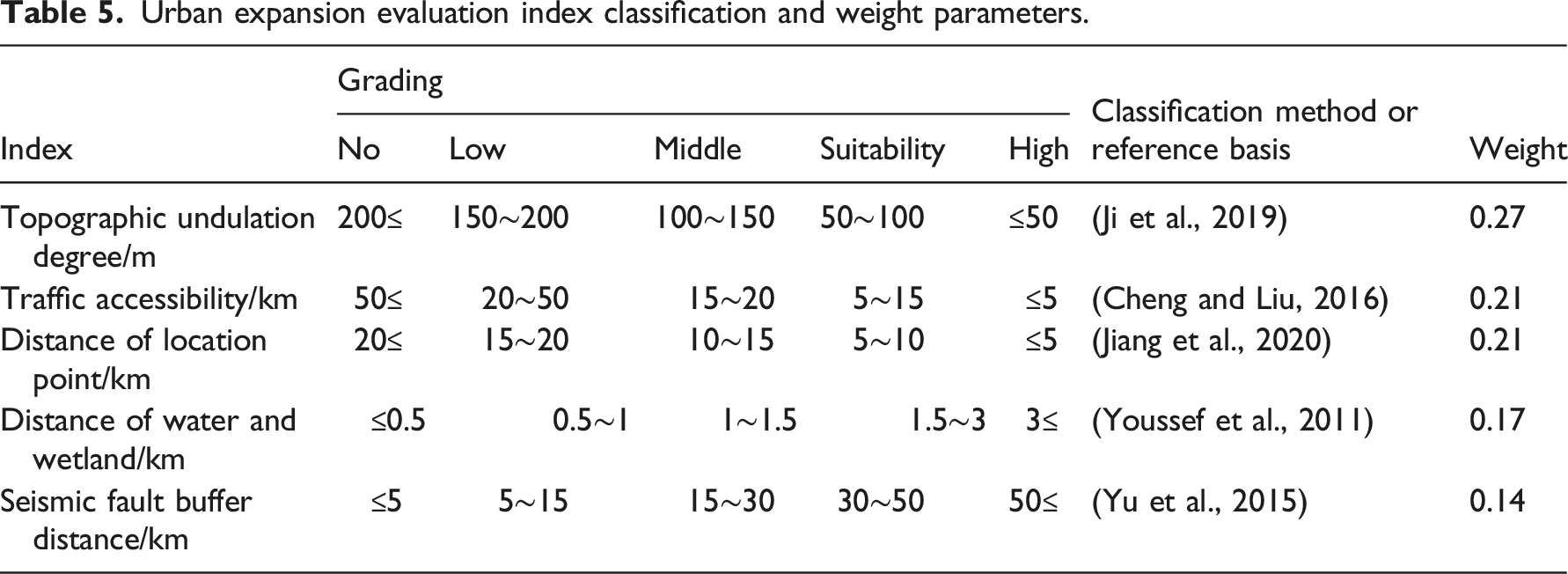
3.3 Urban expansion evaluation
Urban expansion evaluation index classification and weight parameters.
3.4 Comprehensive suitability evaluation
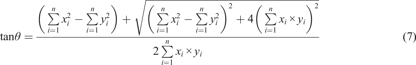
The comprehensive evaluation of urban development suitability brought together the results of the constraint and expansion evaluations. The spatial layout of the three dimensions (ecological protection, agricultural protection, and urban expansion) was weighted and overlaid to arrive at a comprehensive and multi-level spatial development pattern for Zhengzhou. The spatial overlay weights of ecological protection, agricultural production and urban expansion were assigned as 0.37, 0.21, and 0.42, respectively. To objectively describe the overall distribution of urban development suitability comprehensive evaluation results, this study employed a quantitative approach using the standard deviation ellipse (SDE) to delineate the spatial organization, outline, and dominant distribution direction of the research object. The SDE consists of three components: the standard deviation along the X-axis (short axis), the standard deviation along the Y-axis (long axis), and slew rate (θ). The X and Y axes represent the alternative and dominant directions of spatial distribution elements, respectively, with their length demonstrating the degree of dispersion in each direction. Furthermore, θ (i.e., the angle obtained by clockwise rotation from the north direction to the long axis of the ellipse) illustrates the primary trend of geographical element distribution (Liu et al., 2023). Calculation formulas for each parameter were as follows: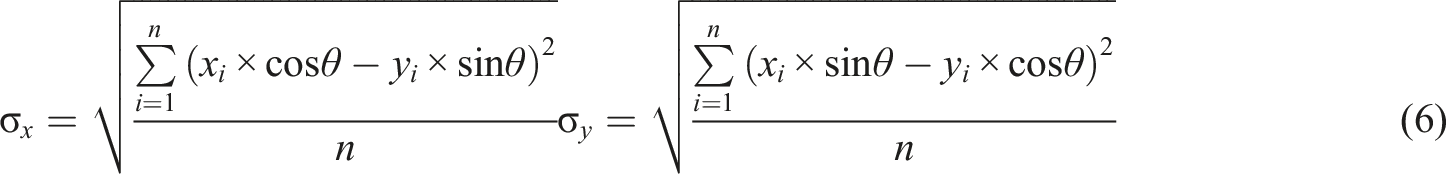
where σ x and σ y are the standard deviation along the X and Y axes, respectively; x i and y i are the coordinates of the SDE’s centroid.
In this study, SDE was established for the highly suitable and suitable areas of comprehensive suitability evaluation in Zhengzhou City. And a circular area with a 30 km radius that could cover the whole Zhengzhou central urban area was constructed with a center point at 113°41′ E and 34°44′ N (located in Erqi District). This circular area was divided into 8 equal slices, with the line north by east at 22.5° as the starting point. By analyzing the land characteristics at different levels of suitability in each direction, the development trend and spatial characteristics of the area were assessed.
4 Results
4.1 Urban development—Constraints
In the ecological protection evaluation (Figure 3 Spatial distribution of urban development–constraints evaluation results. Area of ecological protection evaluation. L1–L9: paddy land, dry land, forest land, grassland, water, wetland, urban land, rural residential land, and other construction land. Area of agricultural production evaluation. L1–L9: paddy land, dry land, forest land, grassland, water, wetland, urban land, rural residential land, and other construction land.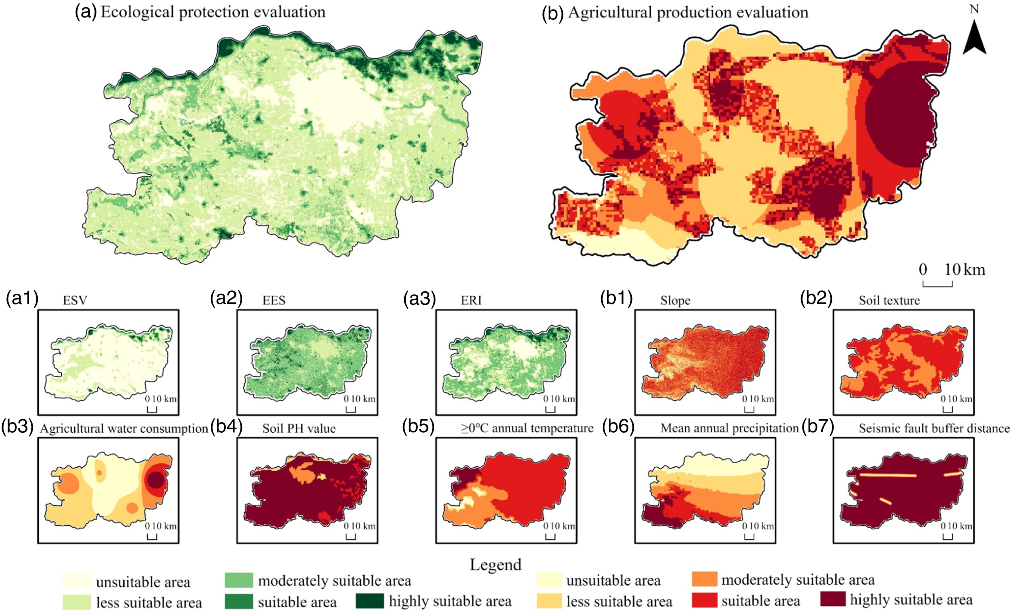
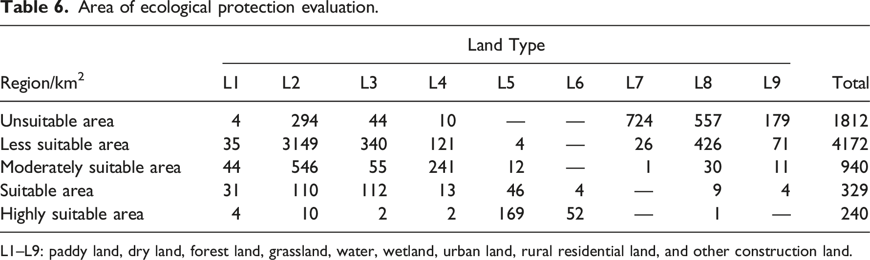
The suitable site (112 km2) was near to the river and the lake, with excellent ecological environment, and has become the main gathering site of parks and forestry parks in Zhengzhou. The highly suitable area (240 km2) was distributed in the north-side of the city, wetland area of the northeast, some pond and reservoirs of the city. The ESV value reached the max here and the water cycle, plants growth, and animals’ activities were of some degree of link. The most suitable area, which were critical eco-environment protection area in the development process of Zhengzhou, belongs to the high-quality ecological zone of the city.
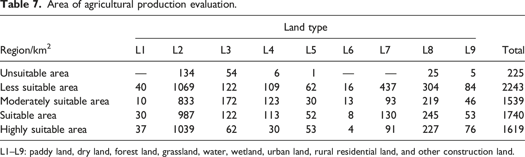
In the agricultural production evaluation, the unsuitable area (225 km2) was concentrated in Xiong Mountain and Naitou Mountain in the southwest of Zhengzhou. This region had complex and diverse topography, mainly dry land and forest land far from towns. The agricultural production base and farming conditions were not mature, and it was difficult to grow crops in this area. The less suitable area (2243 km2) was concentrated in the central part of Zhengzhou, mostly on dry land plains. Although it had a good food transportation capacity, it was less suitable for agricultural production activities in its overall spatial layout. The moderately suitable area (1539 km2) was quite discrete, with small patches in Gongyi and Dengfeng, and in an encircling pattern in Xingyang and the central urban area of Zhengzhou, involving diverse land types. These areas were also priority areas for urban development, with agricultural production conditions but also some complex obstacles. The suitable area (1740 km2) was distributed around the rural residential land, with obvious clusters in the outer edge of Zhongyi and the central and western part of Gongyi. There were obvious advantages in terms of natural conditions and water irrigation. The highly suitable area (1619 km2) was mostly on the periphery of the rural residential land, with some production potential. It was widely distributed over central Xinzheng, central Xingyang, southern Gongyi, and most of Zhongmu.
4.2 Urban development—Expansion
The evaluation of urban expansion was a comprehensive characterization of the spatial development potential and resource utilization of the country, which reflected the trend of urban land expansion and the degree of suitability of orientation. As can be seen from Figure 4, the areas with higher development potential were concentrated in the southeastern part of Zhengzhou, with regional characteristics such as lower topographic relief, better accessibility, and mostly dry land cover, which made land development less difficult. The western part was mostly mountainous or had other areas with drastic elevation changes, and the environmental capacity for supporting construction and development was weak. In addition, this area was far from the city center, so the radiation effect of human activities was not significant. Spatial distribution of urban expansion evaluation and factors.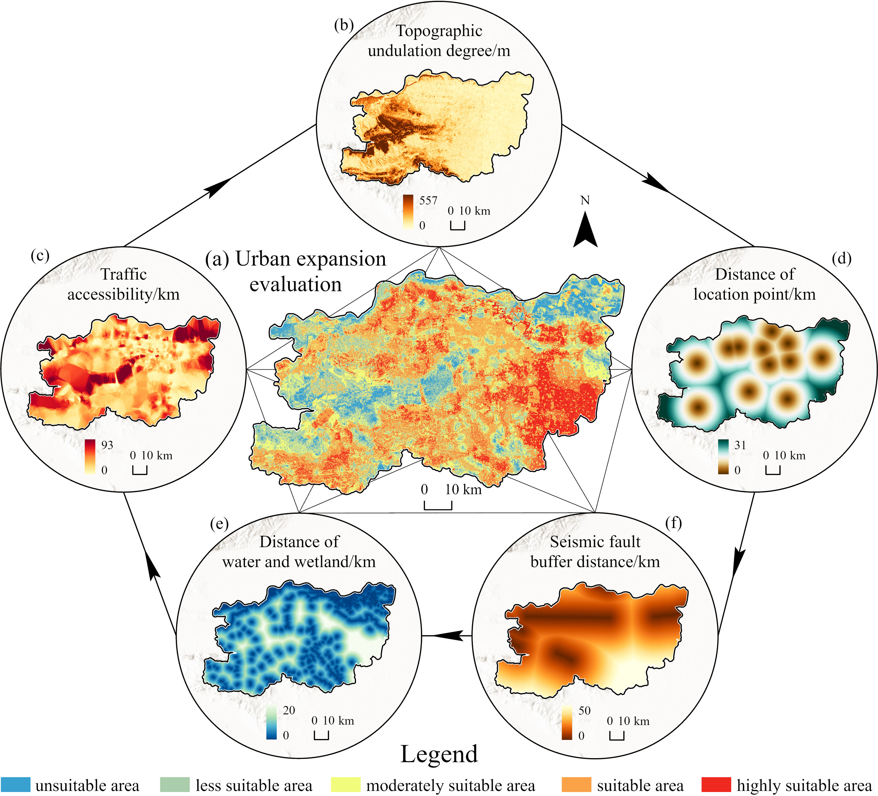
Evaluation result of urban expansion.
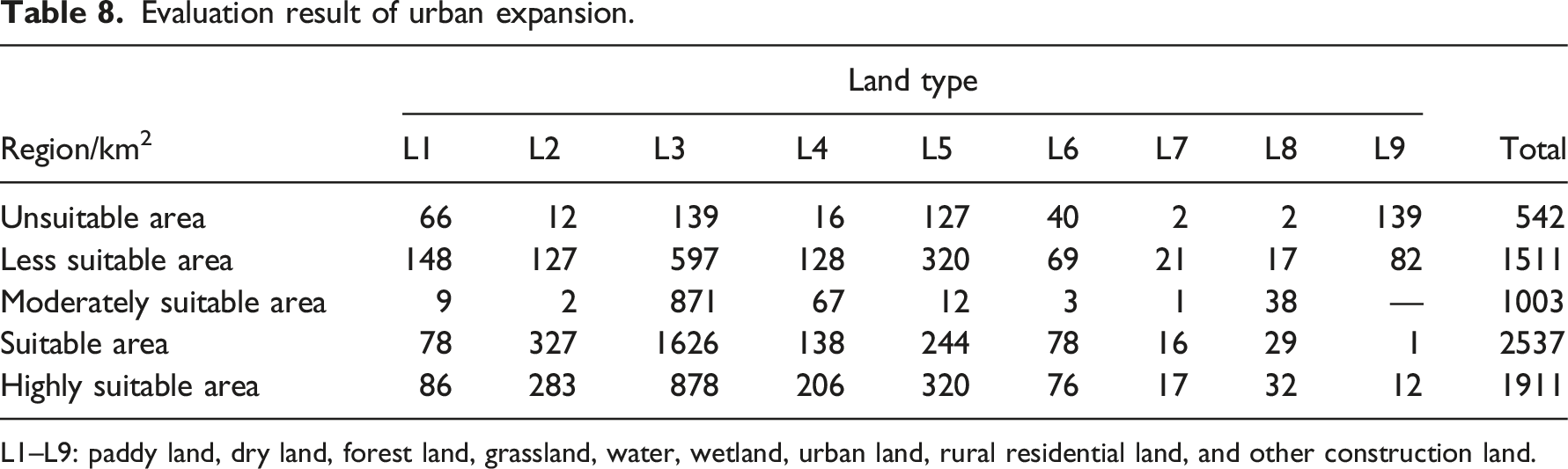
L1–L9: paddy land, dry land, forest land, grassland, water, wetland, urban land, rural residential land, and other construction land.
4.3 Comprehensive evaluation of urban development suitability
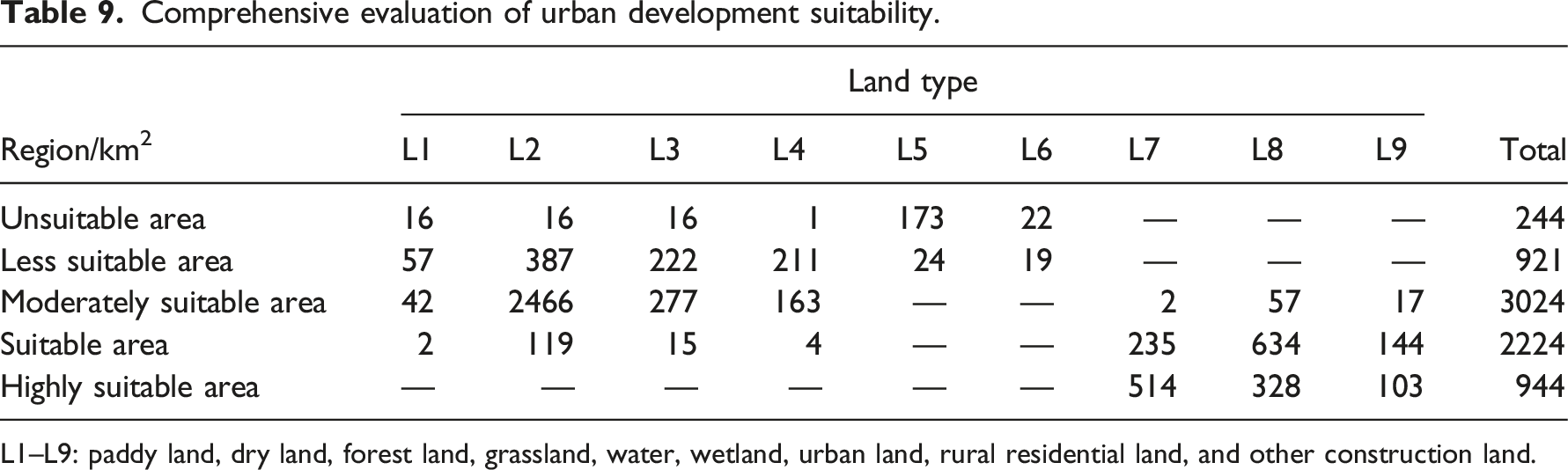
In the comprehensive evaluation (Figure 5), the unsuitable area covered a total of 244 km2 (Table 9). The main land types were the northern waters and inland lakes, covering 173 km2, which were prohibited from development in the process of urban expansion. The less suitable area was concentrated in the northeastern paddy land, water and wetland, western woodland and grassland, and dry land with high agricultural production evaluation, and the ESV of the area was more significant. The moderately suitable category covered the maximum area year-on-year in the comprehensive evaluation, and included all land types except water and wetland, covering a total area of 3024 km2. Dry land covering 2466 km2 was the primary input source, and the northwestern grassland and woodland were the second and third year-on-year, with areas of 277 and 163 km2, respectively. The suitable category covered an area of 2224 km2, concentrated in the periphery of the city center, mainly on rural residential land, urban land, and other construction land. This land was a priority expansion area for urban development, with low ecological protection and agricultural production suitability. The highly suitable area covered an area of 944 km2, with “enclave” type patches in the inner and peripheral areas of urban land. The distribution of rural residential land was relatively scattered, and other construction land was gradually merged into a continuous development area of urban land. Spatial classification in 2020 and spatial distribution of comprehensive evaluation of urban development suitability. Comprehensive evaluation of urban development suitability. L1–L9: paddy land, dry land, forest land, grassland, water, wetland, urban land, rural residential land, and other construction land.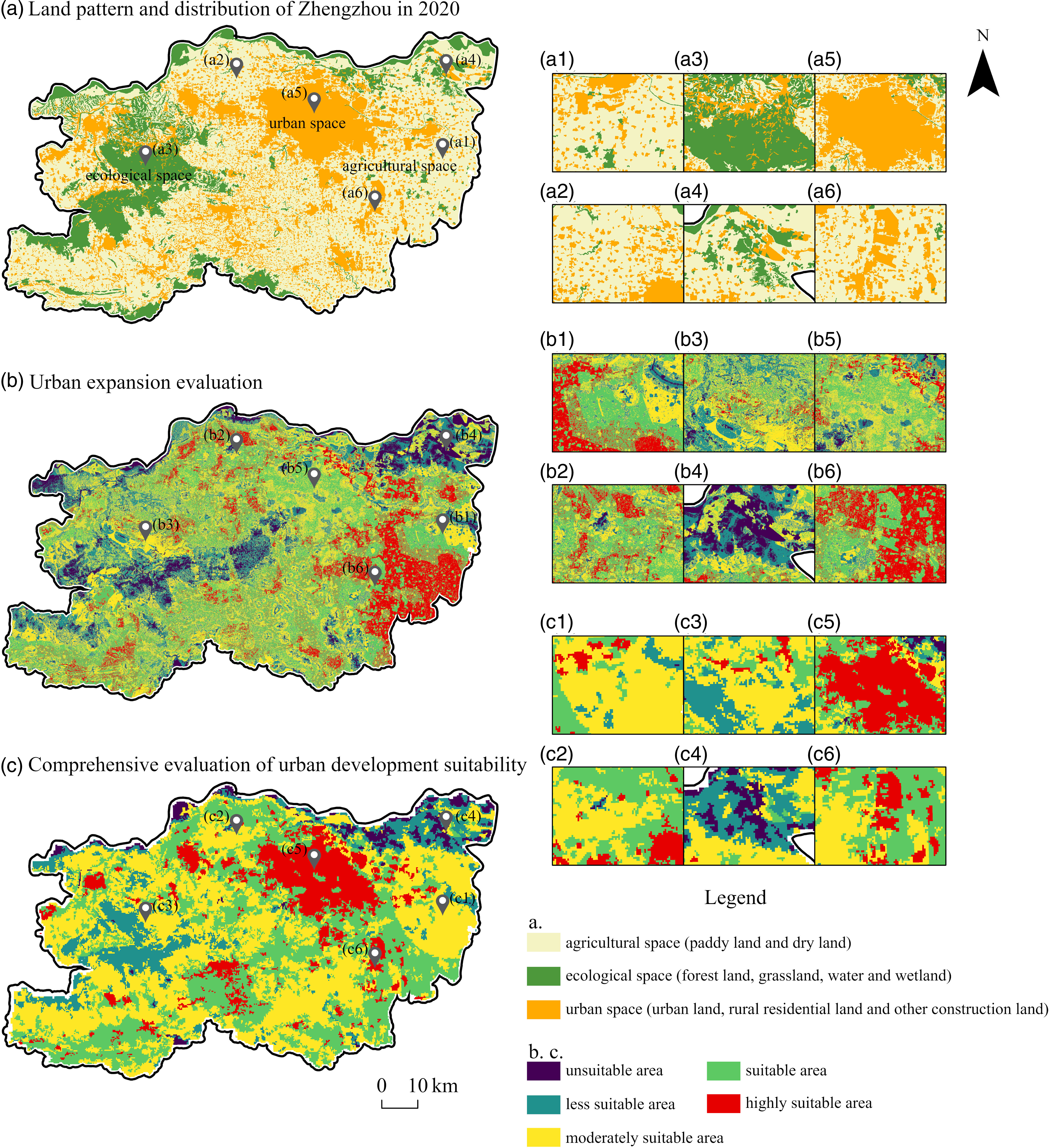
The comprehensive evaluation showed that the spatial distribution of patches had better consistency with actual land use pattern in Zhengzhou in 2020, and there was a difference in the distribution of suitable and highly suitable area in comparison with the simple urban expansion evaluation. Along the Yellow River, tourist amenities and parks were located close to ecological space. Out-spread expansion of these artificial landscapes in the evaluation of urban scale had higher suitability, which had detrimental effect on the ecological preservation and good development of the Yellow River basin. The comprehensive evaluation indicated that the distribution of unsuitable and less suitable area along the Yellow River was unfavorable for urban development, which was to limit the human-building activities in their immediate surroundings, therefore it was also better to protect the natural ecological space. In the area to the southwest of the city, the high suitability area for urban expansion evaluation was judged, and it was found that the area is flat in the subsurface, and has low ecological foundation, so the area close to the middle is considered to have the advantage in the future urban expansion. But southern Zhongmu is a main area for agricultural spatial development and influenced by the policy that the area would become largely leisure agriculture in the future, and it fits the corresponding planning requirement in terms of comprehensive evaluation. Summarizing, the comprehensive evaluation of urban development suitability has more favorable guiding function for future direction and degree of city construction.
4.4. Spatial characteristics and policy suggestions of urban development suitability
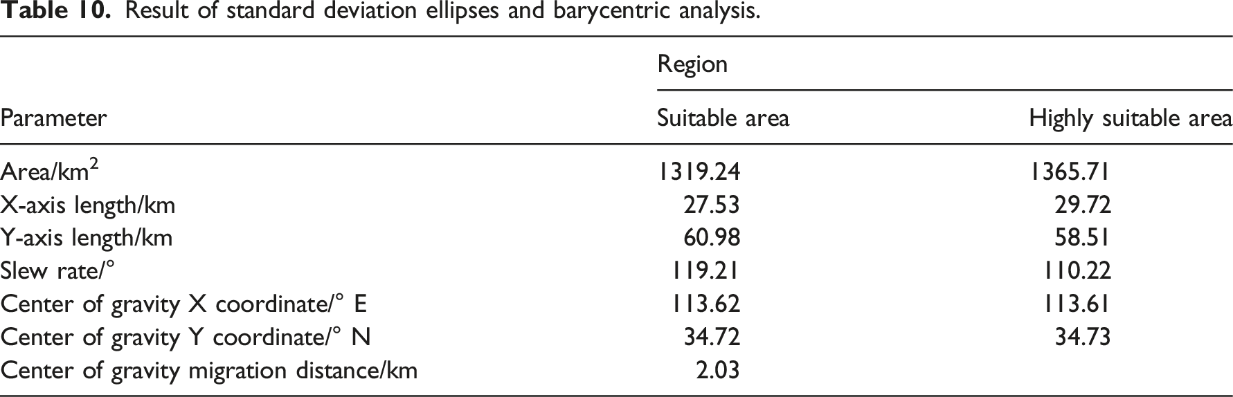
The SDE’s centroids for the highly suitable and suitable areas were identified as being situated in Erqi District and Zhongyuan District (Figure 6), respectively, and the distance between the two points was 2.03 km (Table 10 and Table 11). The area of the ellipses were 1319.24 km2 and 1365.71 km2, respectively. From the perspective of the whole area, the highly suitable land in the aviation port area was more concentrated, while the suitable land in Xingyang and Shangjie was relatively fragmented. The development intensity of the central urban area was higher in the eastern and southeastern directions than in the western and northwestern directions. The highly suitable area covered most of the urban land in the central region, with an elliptical slew rate of 119.21° and a Y-axis length of 60.98 km, expanding more obviously to the northwest and southeast. The suitable area was mostly concentrated in the peripheral areas of existing cities, and its elliptical rotation rate was slightly reduced, forming an east-west spatial pattern with a Y-axis length of 58.51 km. The development pattern was more intensive in the direction of their expansion. Analysis of the spatial characteristics of the central urban area. Result of standard deviation ellipses and barycentric analysis. Result of eight-dimensional equal-sector analysis of the central urban area.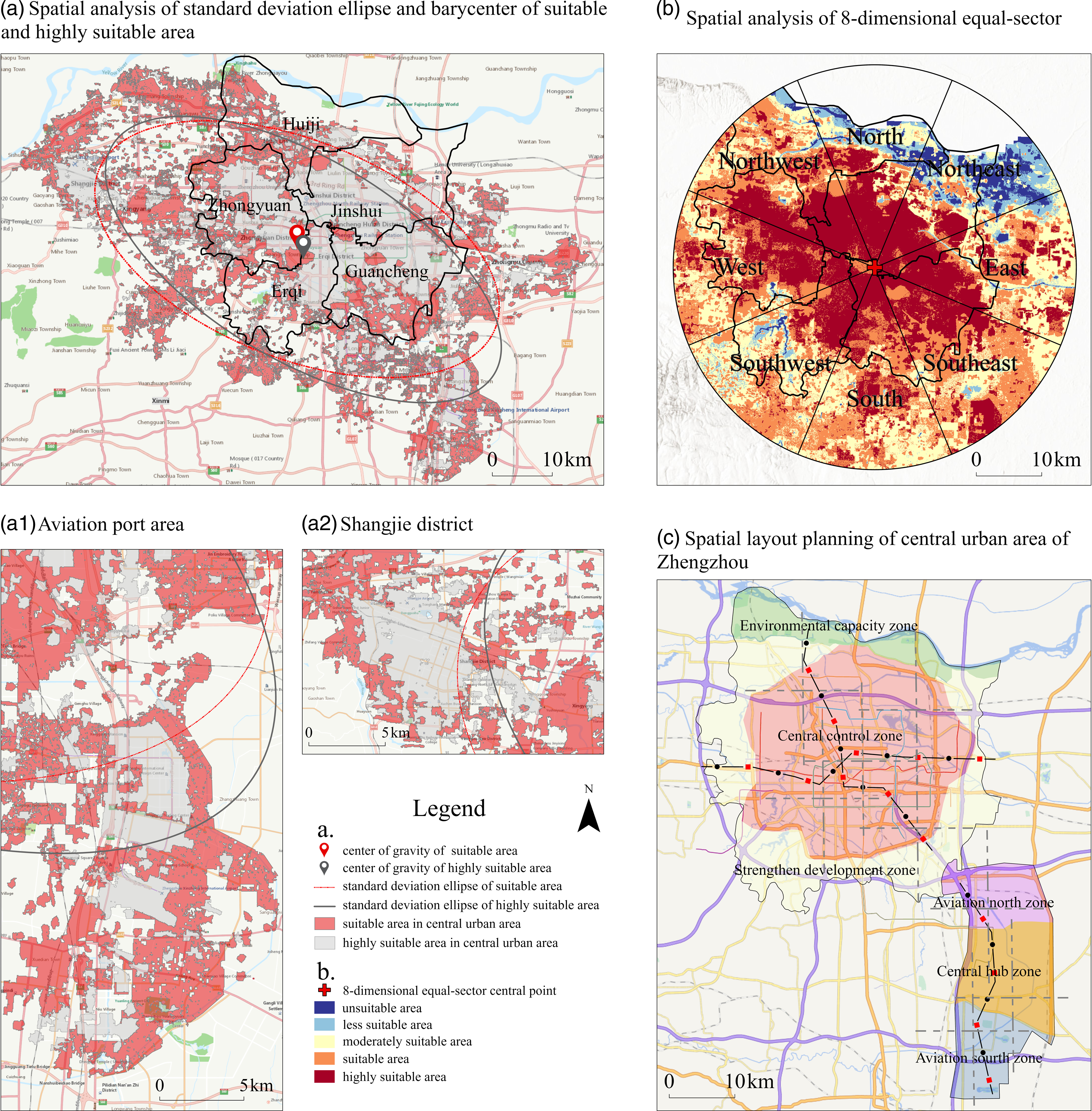
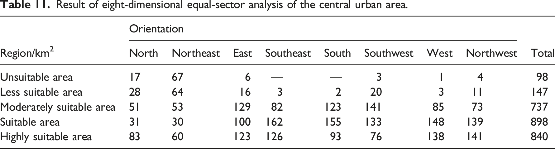
The results of the comprehensive eight-direction and other sectoral analysis showed that there were fewer areas for development in the northeast direction, with a high suitability area of 60 km2, which extended to Longzi Lake. The suitable area was 30 km2, which extended to Zhengzhou Industrial and Commercial College. The moderately suitable area in the southeast direction covered 82 km2 and was concentrated in the intersection of the Airport Expressway, Beijing–Hong Kong–Macao Expressway and South-North Water diversion central main canal, which was a potential development area for transportation land and urban ecology. The topography in the southwest direction was more complex, with significantly higher topographic relief than in other directions, and it contained ecological constraints such as the Jalu River and large areas of woodland. The moderately suitable area covered a total area of 141 km2, but the development trend of the central urban area towards it was weak. The western highly suitable and suitable areas were ranked second and third in area year-on-year and they were the main development orientations after the southeast direction. However, there was a large area of cultivated land between Zhengzhou Ring Road and Metro Line 14, resulting in obstacles to the geospatial integration of the central urban area with downtown Xingyang and the center of Shangjie District.
The evaluation results show that the area of highly suitable and suitable ecological areas in Zhengzhou is 569 km2, which is mainly distributed among the concentrated watershed area in the north and the ecological connotation area of Song Mountain in the southwest (Figure 6(a)). The distance between the urban population concentration region and the ecological region in the southwest is relatively large, and the possibility of spatial or land conflicts between human development activities and them in a short period of time is small, and the trend of expansion in their direction is not obvious. However, water fields along the Yellow River and paddy land in the northeast near the central urban area had high ESV and ERI values, and their potential spatial limitations to urban development existed. Especially under the trend of “Zheng-Bian integration” between Zhengzhou and Kaifeng in the east, the ecological space in the northeast is more likely to be encroached. Highly suitable and suitable areas for agricultural production are concentrated in the eastern and southeastern parts of the central urban area (Figure 6(b)), characterized by flat terrain, fertile soil, good agricultural water supply and convenient transportation, and the development of modern agriculture and scientific planting technology is the main direction in the future, because the area is close to the urban development trend line. Suitable area for agriculture in the northwest have high ecological value due to their proximity to woodland and grassland, but water resources are more restricted. The spatial layout of agricultural land should be scientifically adjusted according to crop cultivation needs to meet irrigation water consumption and regional water use structure. The development potential for the central urban area is significant along the southeast-northwest axis, and has excellent geographical, transportation, and location interaction advantages over the aviation port area. The central urban area ought to expand the development space in an orderly manner, and the land stock should be tapped mainly in highly suitable and suitable areas to achieve an effective synergy development mechanism with the aviation port area. The following recommendations are made for the research results and the current land use spatial planning of the study area: (1) The central urban area of Zhengzhou can be divided into two parts: the main region and the aviation port region (Figure 6(c)). Together, these form a general spatial layout of “two axes and two veins, three corridors, six districts, and eight cores.” To the north of the Huanggu Line is the key control area for ecological protection and high-quality development of the Yellow River Basin in Zhengzhou, and this area can be used as an outer wedge-shaped green belt for the urban ecological environment. (2) The central urban area is the main gathering place of “double veins and double corridors” and “two corridors and four cores” in Zhengzhou, covering all the old city districts in the area. With Erqi District as the main center of the city, this area can promote the functional layout of the intersection of administrative districts, infill of empty space and realize urban renewal. The southern part of the central city has a low proportion of existing urban land but is suitable for development and is a key area for the future peripheral development. (3) The construction of the aviation port area should be integrated and linked with the central urban area, forming a spatial strategy of “integrating the north with the center and leading the south.” The northern part of the port area has good transportation conditions, which are important for the development of airside industries and for strengthening the functional links with the central urban area. The central part of the port has Xinzheng Airport, which can provide the basic conditions for the development of a dry port industry and an aviation-based economy, and enhance the status of Zhengzhou as a comprehensive transportation hub. The port south district is important for the synergistic development of Xinzheng and Weishi and can lead the surrounding industrial units through the core location of the port south logistics base and Shuanghe Lake.
5. Conclusions and discussion
5.1 Conclusions
This study constructed a comprehensive evaluation system for urban development suitability based on multiple attributes and dimensions. The system started with three types of evaluation: ecological protection, agricultural production, and urban expansion, and then analyzed the spatial scope and structural characteristics of the expansion of the central urban area under the constraints of ecological protection and agricultural production. This approach provided a scientific basis for rational planning of the direction of urban development and control of the intensity of expansion in the study area. The main conclusions were as follows: (1) The evaluation of ecological protection and agricultural production showed that ecological protection was the more important factor for sustainable urban development, with the areas along the Yellow River, nature reserves and farmland with high ecological value in Zhengzhou City being the key protection regions, prohibiting the threat of spatial encroachment by human development activities. (2) In the evaluation of urban expansion, the unsuitable and less suitable areas were less exposed to human activities and have outstanding ecological values. The scattered distribution pattern of suitable and highly suitable areas was notable. The region with high suitability for urban expansion was to the southeast of the central urban area, which was mainly covered by dry land. (3) In the comprehensive evaluation of urban development suitability, the clustering effect of suitable and highly suitable areas with development potential were more obvious, and the factors of expansion to the periphery were more in line with the real development conditions. The overall development suitability of Zhengzhou City showed a central peripheral distribution pattern, with urban areas and counties as the core for agglomeration and expansion to the periphery. (4) The development suitability of the central urban area followed a southeast–northwest direction as the main development line and expanded intensively to the east and west. The trend of urban development to the north was weak. The Erqi District was characterized by greater topographic relief and lower development suitability ratings. In the eight-directions analysis, the southeast was still the preferred direction for urban development, with good development conditions, which further increased the development potential of the area.
5.2 Discussion
Multi-attribute evaluation is a method of incorporating the overall representation of complex factors, such as the quantitative integration of ecological, agricultural, demographic, and economic variables. This method allows for a comprehensive multi-dimensional evaluation based on a scientific statistical profile. The results of the comprehensive evaluation of suitability constructed in this study are basically consistent with the system and philosophy of related studies (Dilishati et al., 2019). Ecological protection and agricultural production are the constraining factors of urban expansion. Their inclusion can improve the feasibility of evaluation by considering the environmental management and cultivated land protection involved in urban development. Compared with other studies (Wang et al., 2020; Tang et al., 2015), the single index of ecological and agricultural evaluation in this study has a dual nature. It can also be used as an important reference factor in urban expansion, so that the evaluation results can meet multiple spatial needs. Central urban areas are mostly regions with high concentration of urban development and obvious spatial differentiation, and it is difficult to quantify the extent and scope of edge expansion using only the administrative boundaries of central urban areas. Ecological protection evaluation of ESV, EES, and ERI was designed with multidimensional, which enabled particular spatial information to be accurately obtained according to the basis of ecologic diversity. If the traditional single-layer evaluation system (Wang et al., 2020; Yin et al., 2020) had been used, there might have been a conflict between the area with low ecological suitability and the construction land. This study adopts a global perspective and gradually decreases the scale, which allows analysis of the spatial characteristics of central urban area, provides a reference for the construction of the suitability evaluation system, and provides a new perspective for the development and optimization of land space in Zhengzhou.
However, there are still some shortcomings in this study, such as the use of the raster calculator to assign weights in spatial overlay. It let the final evolution results to reflect a win–lose pattern. However, in the actual spatial fusion, there is a co-evolution process and mechanism, and the layout of various spatial land use types should be the result of dynamic fusion. This needs to be explored in depth by the formula of spatial overlay or software development.
Footnotes
Declaration of conflicting interests
The author(s) declared no potential conflicts of interest with respect to the research, authorship, and/or publication of this article.
Funding
The author(s) disclosed receipt of the following financial support for the research, authorship, and/or publication of this article: This work was supported by National Natural Science Foundation of China Youth Project (42201110).