
Abstract
The lower Usumacinta–Grijalva River Basin contains one of the richest biodiversity landscapes of the Maya region. Our research is based on (1) an integrative literature review of the geomorphological and archaeological papers published about the lower Usumacinta–Grijalva River Basin and (2) topographic analysis of digital elevation models using a geographical information system to explore the relationship between past human settlement and landscape accessibility along the coastal plain of Tabasco. This work provides a new synthesis of previous research and proposes new models for the geomorphic evolution of the lower Usumacinta–Grijalva River Basin in the context of four millennia of human land use and settlement. For the evolution of the strand-plain of the Usumacinta and Grijalva rivers, there are two published geochronological models that provide different chronologies. We discuss here how both geochronological models encompass Pre-Columbian human settlement in the delta. Interestingly, we notice that one of them overlaps a possible high-magnitude flood event (or events) that drove large geomorphic change around 750 CE (1200 BP), with implications for settlement patterns and chronology. Based on topographical analysis of the eastern-distal sector of the Usumacinta–Grijalva delta, we propose a new model for the evolution of this area with implications for the human occupation during the Mesoamerican Terminal Classic and Early Postclassic on the delta. As one of the main conclusions, we propose that the Pom–Atasta water bodies predate much of the Usumacinta–Grijalva delta and the most recent phase of delta building overlays the original lagoon barriers, resulting in a geomorphic setting more attractive to local human occupation after the Terminal Classic period. According to one of the geochronological models of the delta, this dates to ca. 900 CE, preceding the establishment of nearby settlements such as Atasta.
Keywords
Introduction
Water supply in all its forms is necessary for the development and growth of civilizations (Yevjevich, 1992). To ensure water supply, settlers choose areas where fresh water is accessible, but where inaccessible, people have modified the environment in numerous ways to assure its availability with canals, aqueducts, diversions, wells, reservoirs, and many other water supply systems (Mithen, 2010). But these water engineering features can be vulnerable to natural hazards like floods (Macklin and Lewin, 2015; Penny and Beach, 2021). In this sense, ancient societies were affected (positively and negatively) by hydrologic changes such as floods, droughts, groundwater levels, river avulsions, channel changes, sea-level rise, and modifications of sediment supply and erosion rates (Gunn et al., 2019a). River avulsion, for example, is a prominent driver of hydrologic change and occurs when a river’s channel changes rapidly to a new course commonly in deltas or the lower courses of streams due sea-level rise, sediment buildup, tectonics, and others (Jones and Schumm 1999; Chadwick et al., 2020).
Understanding long-term water resource challenges and ancient societal interactions provides a range of ways societies responded to hydrological changes. These past responses can also help us understand how current societies can respond and mitigate future events such as a recent study of Holocene environmental change of the Central American Isthmus (Harvey et al., 2021). In this sense, we study here how long-term water resource challenges affected the ancient Maya in the Usumacinta River Delta. Maya culture occupied a wide area of southern Mexico and Central America during the Preclassic (1000 BCE-200 CE; 2950-1750 BP), Classic periods (c. 250-900 CE; 2900-1050 BP), and Post Classic up to European Conquest in the 16th Century. In particular, climatic perturbations coincided with major periods of cultural and political change, especially the Late Preclassic (c. 1700 BP) and the Terminal Classic transitions (c. 1000 BP) (e.g., Beach et al., 2015; Dunning et al., 2012; Luzzadder-Beach et al., 2012, 2016). The Delta’s broader watershed, the Usumacinta–Grijalva, is Mexico’s largest river system and one of the richest regions of biodiversity in the world (Hufnagel, 2021). It is also a complex physical and human landscape that has immense archaeological value in the hearth of the ancient Olmec and Maya cultures (Inomata et al., 2020, 2021). The Usumacinta–Grijalva valley has been an important source for water, fishing, and crop irrigation, and an ideal route for commerce and navigation from the Gulf of Mexico inland to the heart of the Maya world (Hudson et al., 2005). As a result, many Maya settlements occupied the banks of the Usumacinta through the late Holocene.
This work aims to synthesize prior research and proposes new models for the geomorphic evolution of the lower Usumacinta–Grijalva River Basin over four millennia of human land use and settlement. We start by reviewing the landscape evolution literature about the lower Usumacinta–Grijalva River Basin over this chronology. We compare two published geochronological models for the evolution of the Tabasco Delta in terms of how both accommodate Pre-Columbian human settlement. We also add new topographical analyses to explore the relationship between past human settlement and landscape accessibility along the coastal plain of Tabasco. We summarize our current knowledge of the lower Usumacinta–Grijalva River Basin in terms of geology, geomorphology, vegetation, and human occupation, and then evaluate the evolution of this area during the late Holocene, the period of substantive human settlement and the genesis and cultural evolution of Mesoamerican peoples.
Study area
General geographical characteristics of the lower Usumacinta–Grijalva River Basin
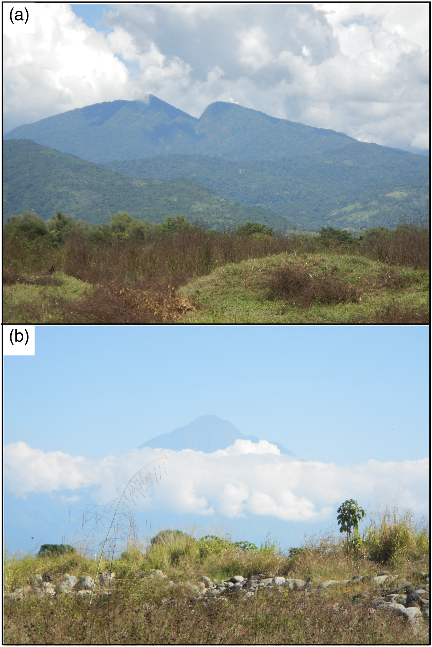
The lower Usumacinta–Grijalva River Basin includes the entire Mexican state of Tabasco and parts of the Mexican states of Chiapas and Campeche (Figure 1). The delta of this river system covers 300 km along the Gulf Coast with c. 500 beach-dune-ridge sequences built over the last 6500 years (Psuty, 1965). The sediments of the delta and the broader lower Usumacinta–Grijalva River Basin come mostly from the materials eroded from the Sierra Madre de Chiapas and Altos de Chiapas, mainly composed of diorites and granites belonging to a Paleozoic batholith (Cros et al., 1998; Morán-Zenteno et al., 1999; Figures 1 and 2(a)), and in lesser amounts, from the volcanic ejecta of the El Chichón and Tacaná volcanoes (Solís-Castillo et al., 2014; Figures 1 and 2(b)), from different volcanoes located in the Central American Volcanic Arc (Figure 1), and even lesser amounts from Saharan dusts. The highland regions of the basin have high relief and heavy precipitation (up to 3 m per annum), leading to high rates of denudation (Cook et al., 2022). The coastal plain geology includes a sequence of seaward-dipping Pleistocene terraces and Holocene deltaic deposits that partially cover the Pleistocene terraces (Thom, 1967; West et al., 1969; Solís-Castillo et al., 2013). The terraces date from 5 to 126 ka and their sediments derive from volcanic sediments from the Central American Volcanic Arc (Solís-Castillo et al., 2013). Classic studies by Psuty (1967) and West et al. (1969) proposed a similar terrace chronology and formation by denudational processes over the highlands during the last interglacial periods. Study area in the lower Usumacinta–Grijalva River Basin. Locations of archeological sites mentioned in the text are as follows: 1. Bonampak, 2. Yaxchilán, 3. Pomona, 4. Aguada Fénix, 5. Balancán, 6. Vicente Guerrero, 7. Tierra Blanca, 8. El Pochote, 9. Palenque, (Usumacinta region) 10. Itzamkanac, 11. Comalcalco, 12. San Andrés, 13. La Venta, 14. Islas de Los Cerros, 15. Guerrero, 16. Juárez, 17. El Coco, 18. Potochán (currently Frontera), 19. Jounuta, 20. Atasta, 21. Aguacatal, 22. Xicalango. Maya site locations from www.mayamap.org and from the archaeological literature. The modern cities in the area (red starts) are as follows: 1. Villahermosa and 2. Playa del Carmen. Inset map countries of Central America correspond to the following: 1. Guatemala, 2. Belize, 3. Honduras, 4. Nicaragua. The base map was obtained from 90 m ASTER-DEM available and downloaded from https://earthdata.nasa.gov/. Usumacinta and Grijalva (U/G) River Basin defined in Narikka (2020). Denudation processes at the highlands of Chiapas are main source of the sediment deposited by the Usumacinta and Grijalva Rivers around the Mexican Maya Southern Lowlands. In A, a view of the Sierra Madre the Chiapas which is a massif with peaks over the 3000 m asl composed by crystalline materials and in B, the Tacaná volcano, which is a source of the volcanic sediments transported by the rivers.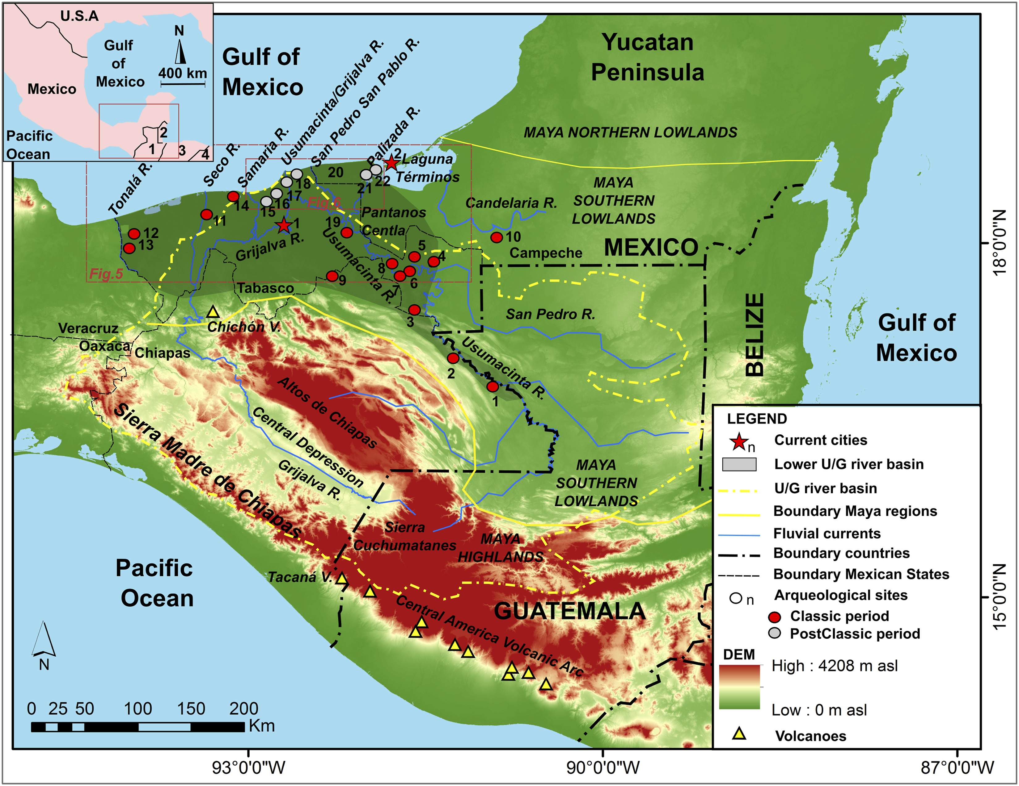
The Usumacinta and Grijalva rivers flow separately until they join ∼15 km from the Gulf of Mexico. Both rivers rise in the Sierra de los Cuchumatanes, in Guatemala, but their pathways divert downstream. The Usumacinta River abruptly descends the Sierra de los Cuchumatanes towards the north, into the lowlands, where it flows down to the coastal plain of Tabasco, having a length of ∼ 1100 km (Day et al., 2003). The Grijalva River flows westward, through the Central Depression of Chiapas, to the lowlands very close to the state of Veracruz, with a ∼ 640 km length (Hudson et al., 2005). Together the rivers produce a mean annual discharge of ∼ 2678 m3 s−1 from a basin area of ∼112,000 km2 (Benke, 2009).
The climate of the lower Usumacinta–Grijalva River Basin is humid tropical (AM in the Köppen classification) with annual rainfall highly concentrated in a May to October rainy season (Grodsky and Carton, 2003). During the summer season, the lower Usumacinta–Grijalva River Basin is affected by tropical storm activity (Rosengaus-Moshinsky et al., 2002). The mean annual rainfall is ∼ 3 m in the upper basin and ∼2 m in the lower basin (Andrade-Velázquez and Medrano-Pérez (2020). Dinerstein et al. (2017) defined three main ecoregions in the region: the tropical and subtropical moist broadleaf forest in the floodplains of the Usumacinta and Grijalva rivers and in the Tabasco Delta, the tropical and subtropical coniferous forest in the most elevated parts of the mountain ranges of Sierra Madre de Chiapas and Altos de Chiapas, and tropical and subtropical dry broad leaf forest in these mountain ranges piedmonts.
Cultural history and settlement patterns of the lower Usumacinta–Grijalva River Basin
Prehistoric and historic cultural periods of the lower Usumacinta–Grijalva River Basin according to Demarest (2004) and Sharer (2006).
The archaeological and paleoecological records of the lower Usumacinta–Grijalva basin show that humans had influence on this region since at least the earliest forest clearance and domesticated maize pollen by ∼ 7000 BP and multiple other domesticated crops by 4000 BP in the Grijalva River delta coastal wetlands (Pope et al., 2001). The first complex Mesoamerican society, the Olmec (Coe and Diehl, 1980), developed in the Early Preclassic period, with sedentary communities that inhabited the Gulf Coast region. The Olmec were part of a regional-scale trade system that extended from present-day central Mexico south to Honduras and El Salvador (Rosenswig, 2017). Archaeologists describe early (pre-Olmec) occupation in the region of San Lorenzo Tenochtitlán on the Coatzacoalcos River, around 50 km from the Gulf coast today, by c. 3800 BP (Diehl, 2004). Soon thereafter was the apogee from 3400 to 3150 BP of the Olmec’s large ceremonial and political center of San Lorenzo (Inomata et al., 2021) on elevated (up to 50 m) terrain above the floodplain of the Coatzacoalcos River. By this time, the Olmec started to develop expertise in ceramics, possibly developed early writing (Rodríguez Martínez et al., 2006), and stone carving such as the giant stone head sculptures that epitomize Olmec culture (Coe and Diehl, 1980). By c. 3700 BCE (5650 BP), humans were occupying floodplain levees of the Bari River (a tributary of the Tonalá River) further north, around 12 km from the Gulf Coast, and La Venta became a powerful center with a large population around 2800 BP, situated on elevated terrain on the Tonalá River delta (Rust and Sharer, 1988; Inomata et al., 2013). La Venta arose contemporaneously with many Middle Preclassic Olmec and Maya sites in the Gulf Coast region that mark a new phase of environmental history, featuring the hallmark Mesoamerican organization and architecture of formal complexes of plazas and pyramids as well as extensive land clearance, agriculture, and urbanization (Inomata et al., 2021).
The Maya Classic Period, from 250 to 900 CE (1700-1050 BP) in most locations, developed across much of northern Central America and Mexico’s Yucatan Peninsula and Tabasco and Chiapas States. Evidence for strong hydroclimatic variability starting around 1200 BP coincides with the Maya Late Classic and Terminal Classic (Beach et al., 2015; Cook et al., 2022). Rivers were an integral aspect of the Maya environment, with many key cities established along the Usumacinta–Grijalva River system, allowing the Maya to take advantage of floodplain soils, riverine resources, and transportation. Rivers were a primary form of transport and communication through some parts of the Maya lowlands, though peripheral coastal transport and overland transport prevailed through the karst in Yucatan that has only underground water flow (Cook et al., 2022; Velázquez, 1994) (Figure 1).
The present-day Mexican state of Tabasco, where the Usumacinta meets the Gulf of Mexico, is the northwest limit of major Maya cultural remains (Coe and Houston, 2015). The earliest Maya settlements of this region, often located along riverbanks, date from the start of the Middle Preclassic period, around 1000 BCE (2950 BP). Inomata et al. (2021), for example, identified 478 formal complexes across the lower Usumacinta, Grijalva, and southern Veracruz regions that dated to 1100 to 400 BCE (3050-2350 BP). In the Classic period, settlement patterns favored higher, more easily defensible elevations, above regular flood levels, leaving the lowlands for activities like agriculture and hunting. In the Late Classic period (600-900 CE; 1350-1050 BP), Maya settlements and trading sites existed largely along the main arm of the lower Usumacinta and its tributary from the Petén, the San Pedro River, as well as along the Candelaria River further east. With the end of the Classic period, Maya society in the Usumacinta Basin was greatly transformed, and in the lower coastal regions, the Mayan-Chontales society arose, establishing their capital in Potonchán (Champotón), a port the Conquistadors Hernán Cortés and Bernal Díaz del Castillo mapped and described on first Contact with the region (Chávez Jiménez, 2007). In the Postclassic period, numerous settlements were established across the coastal lowlands, barrier ridges, and coastal islands, much closer to the present-day coastline than earlier Mesoamerican settlements (Thompson, 1964). Major settlements on the coastal plain of the lower Usumacinta and Candelaria, such as Potonchán and Xicalango, and Itzamkanac further upstream in the basin, were occupied up until the time of Spanish Contact. Descriptions of the Chontal Maya and their settlements are detailed in Spanish reports from this time showing settlements situated within (and utilizing) hydrological landscapes dominated by mangroves and swamps, with permanent architecture and infrastructure situated on often isolated elevated sites for settlements (Ruz Lhuillier, 2012). The Spanish settlement of the areas near the mouth of the Grijalva was relatively short-lived. The coastal lowlands around the Grijalva River experienced population declines and settlement abandonments through the second half of the 16th century and into the first half of the 17th century due to illnesses like yellow fewer and malaria (Scholes and Roys, 1968) and pirate attacks and other external threats (Chávez Jiménez, 2007; Koch et al., 2019). Palaeolimnological records from the tropical forests of Guatemala suggest that reforestation in the centuries after the Classic Maya period was swift (Mueller et al., 2010). Moreover, historical records from Spanish conquistadors indicate that by the 16th Century, much of the region from Mexico to Honduras was forested (Turner, 2010).
Since the 16th century, Europeans explored and occupied the well-established indigenous settlements or selected those sites where precious metals could be exploited (Arroyo Abad et al., 2012). During the Colonial period (from ∼1521 to 1820 CE; 429-130 BP), the environment of the Usumacinta–Grijalva River Basin was only slightly modified by humans (Zebadua, 1999). Precious woods were exploited, but in minor quantities. Cacao and coffee plantations were settled in isolated sites along the Central Depression of Chiapas (Weibel, 1998). This period was more catastrophic for the enslaved indigenous people who worked the region’s farms and suffered substantial population declines (Zebadua, 1999).
At the beginning of the 19th century timber throughout the lower Usumacinta–Grijalva River Basin was intensely exploited. Since the rivers were used for timber transportation, the forest was seriously damaged along riverbanks. After 1946 CE (4 BP), timber extraction became more profitable using mechanical devices and more distant areas of forest could be easily removed (Benjamin, 1981). Logging through the 20th century removed nearly all cedar and mahogany species from the Usumacinta and Grijalva basin (West, 1966). Since the beginning of the 20th Century, the petroleum industry initiated around the Usumacinta and Grijalva lowlands (Ortiz Ortiz, 2016), generating intensive environmental impacts with heavy metal contamination of soils (López Morales et al., 2019). Additionally, the control of the water flow of Grijalva River started in 1964 CE with the construction of two large dams: the Netzahualcóyotl dam and the Belisario Dominguez dam, which respectively became the second largest and largest dams of Mexico (http://www.conagua.gob.mx). Since the second half of the 20th century deforestation increased substantially again following modernization of agriculture in the lower Usumacinta–Grijalva River Basin resulting in among the highest deforestation rates in the world (Ochoa-Gaona and González-Espinosa, 2000).
Methods
The first part of our research relies on an integrative literature review of the geomorphological and archaeological papers published on the lower Usumacinta–Grijalva River Basin. To provide a complete view of the landscape evolution of the lower Usumacinta–Grijalva River Basin, we reviewed the fluvial geomorphology literature of the Usumacinta and Grijalva floodplains including documents from the Mexican archives. Additionally, we searched for research published in Spanish in Mexican institutions with special focus on theses and papers published at the database of the National Autonomous University of Mexico.
The second part of our research relies on topographic analyses of digital elevation models using a geographical information system to explore the relationship between past human settlement and landscape accessibility along the coastal plain of Tabasco. We conducted the topographic analyses using a 30 m resolution digital elevation model (DEM) from the ASTER Global DEM dataset freely available at https://earthdata.nasa.gov/ and a 5 m LiDAR DEM freely downloaded from www.inegi.org.mx. The topographic analyses consisted of extracting a topographic profile from the 30 m DEM. Since the DEM data contain errors derived from redundancy of contiguous pixels, the elevation data were smoothed using a moving average window of 300 m. The satellite image interpretation was based on the identification of vegetated and inundated areas using true-color images of Landsat 8 published by NASA, which are available at the USGS webpage (https://earthexplorer.usgs.gov) and from the GoogleEarth® platform. Additionally, we analyzed satellite imagery of the coastal plain of Tabasco, focusing on the understudied easternmost part of the Usumacinta/Grijalva Delta. Locations of Maya settlements were obtained from the Maya map website (www.mayamap.org) and site locations were cross-referenced against various primary and secondary published resources, where possible.
Results and discussions
Integrative literature review of the geomorphological and archaeological papers published about the lower Usumacinta–Grijalva River Basin
Human and fluvial interactions on the Usumacinta and Grijalva floodplains and proximal coastal plain
The Usumacinta and Grijalva Rivers deposited a complex sedimentological record that is the product of climatic variability and coastal dynamics through the late Holocene, but also related to the presence of human activities. These two rivers in the lower Usumacinta–Grijalva River Basin have braided type channels with mobile sand bars and multiple active channels. Both rivers are navigable in their lower courses (Figure 3). Streambanks are in some margins erosive but in others, lateral sediment accretion dominates. Muñoz-Salinas et al. (2016) reported sedimentation rates of 2.94 mm yr −1 (between 1700 AD and 1360 AD; 250-580 BP) for the Usumacinta River and 1.52 mm yr −1 (between 1120 AD and 550 AD; 830–1400 BP) for the Grijalva River in sedimentary margin at the floodplains (sediment rates calculated from full OSL ages published in Muñoz-Salinas et al., 2016). Along the Usumacinta River, Solís-Castillo et al. (2013) described a series of geomorphological units in a sector between the highlands and the coastal plain, where the ancient settlements of Tierra Blanca, Balancan, Vicente Guerrero, and El Pochote are located in different fluvio-terraces levels. Also located in this area is the ceremonial center of Aguada Fénix, the oldest and largest-known Maya construction in the region starting about 1000 BCE (2950 BP) or earlier (Inomata et al., 2020). Different snapshots of the navigable channels of the Usumacinta and Grijalva fluvial system. In A, the Usumacinta channel close to the confluence of the San Pedro tributary; in B, the Grijalva channel close to the bifurcation of the distributary of the Rio Seco and, in C, the channel of the Usumacinta and Grijalva flowing together, very close to the current mouth of these rivers at the Gulf of Mexico.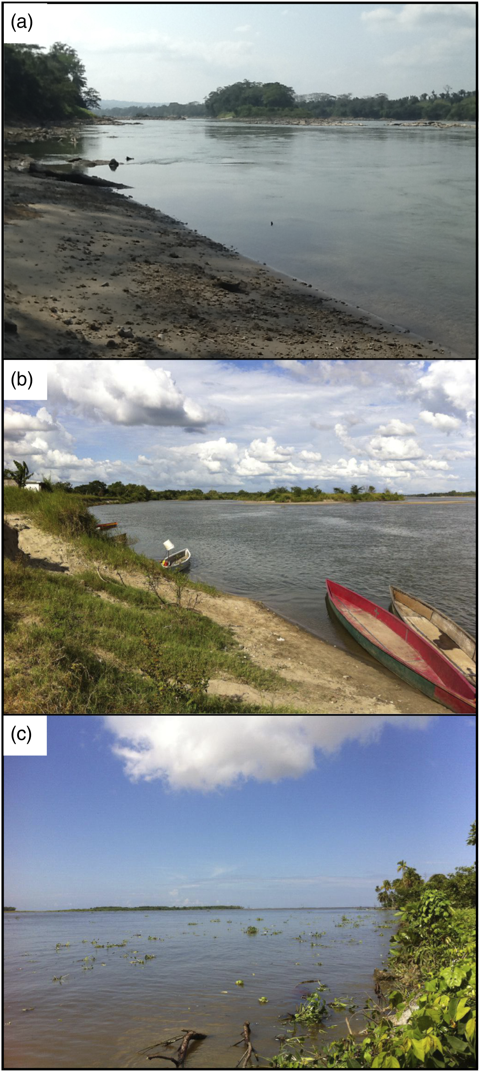
Mendoza et al. (2019) mapped the Pleistocene fluvial terraces of the lowland Grijalva River, where Comalcalco, the largest Classical Maya settlement on the coastal lowlands of the basin sprawled over an area of at least 7 km2 (Priego-Castillo et al., 2009). In the 6–11 centuries CE (1350-850 BP), Comalcalco was the main Maya ceremonial center of the northwestern Maya frontier, and probably connected to the great Maya city of Palenque, c. 150 km south on the Usumacinta River. In the late Classic, Comalcalco was situated on an elevated position somewhat above the floodplain, close to one of the main tributaries of the lower basin, the old Mezcalapa River (the Samaria River today), facilitating transport connections inland and to the coast.
Historical records, which extend back to the 16th century arrival of the Spanish on the Tabasco Gulf coast, show the lower reaches of Usumacinta–Grijalva system to be prone to many avulsions over historical timescales (Mendoza et al., 2019). However, much less is known about the lower river basin’s evolution prior to surveys and mapping in the 16th century, despite a long pre-Hispanic human history of lowland agriculture (especially for Cacao), many minor and several major human settlements, and the use of the natural and artificial canals across the coastal lowlands for transport and agriculture (Siemens, 1983).
To explain the sedimentation of the lower Usumacinta and Grijalva River floodplain, Muñoz-Salinas et al. (2016) used optically stimulated luminescence (OSL) to provide ages for floodplain deposits at different depths, rates of sedimentation, and to help explain the main mechanisms of sediment transport. Samples from the profiles at depths of 1.4 m in both floodplains date to the 5th century BCE (1450 BP). These dates provide a mean sedimentation rate of ∼1 mm yr −1 for the historical period, which agrees with sedimentation rates from other sites in the Maya lowlands (Beach et al., 2015). However, we note that in this study, there has been no clear evidence of enhanced sedimentation dating to the pre-Columbian Maya period (the so-called “Maya Clay” found in deposition basins across Mexico and Central America (Beach et al., 2015; Cook et al., 2022). Three explanations for this disconnect include the coarse chronological resolution of sedimentation studies thus far, the patchiness of sediments from soil erosion (eroded sediments often lie near the site of erosion especially in karst systems that mainly drain underground), and the main sediment sources for the floodplain studied here are in the highlands away from ancient Maya intensive agriculture. An example of sediment patchiness is that much of the karst catchment drains internally with little or no erosion until deforestation but much of this erosion drains locally into nearby water bodies or karst sinks with little or no connectivity to fluvial systems (Beach et al., 2015). Combining the patchiness with the main sources of sediments, Muñoz-Salinas et al. (2016) studied the luminescence resetting of sediment grains transported by the Usumacinta–Grijalva. They observed a general tendency for incomplete resetting of grains that they attributed to low connectivity of fluvial sediment in the lowland environment because of the large volume of sediment mobilized from the highlands that becomes stored for periods in the floodplains. These authors indicate that only during large floods is the sediment likely to be transported downstream, which underscores the importance of large floods in transferring sediments and nutrients to the floodplains (Machain-Castillo et al., 2020).
Flooding is a regular and important part of this landscape with large areas inundated deeply for several months during the summer season in contrast to the areas with “benign” flooding such as the Rio Candelaria, where wetland farming was common (Siemens, 1983). The flood-prone areas were probably well known by the early inhabitants and, today, these areas are occupied mostly by a population living in poverty who have no other land to access (SEDESOL https://www.gob.mx, 2021). This is the case of the contemporary Pantanos de Centla, along the margins of the Usumacinta River (Figure 4), and likely occurred throughout history. Views of houses (in A) and fields (in B) around Pantanos de Centla, a today inhabited area that is located in the floodplains of the Usumacinta River (see Figure 1). This is an area of lower relief and prone to be inundated as can be observed in the pictures that were taken in October of 2015.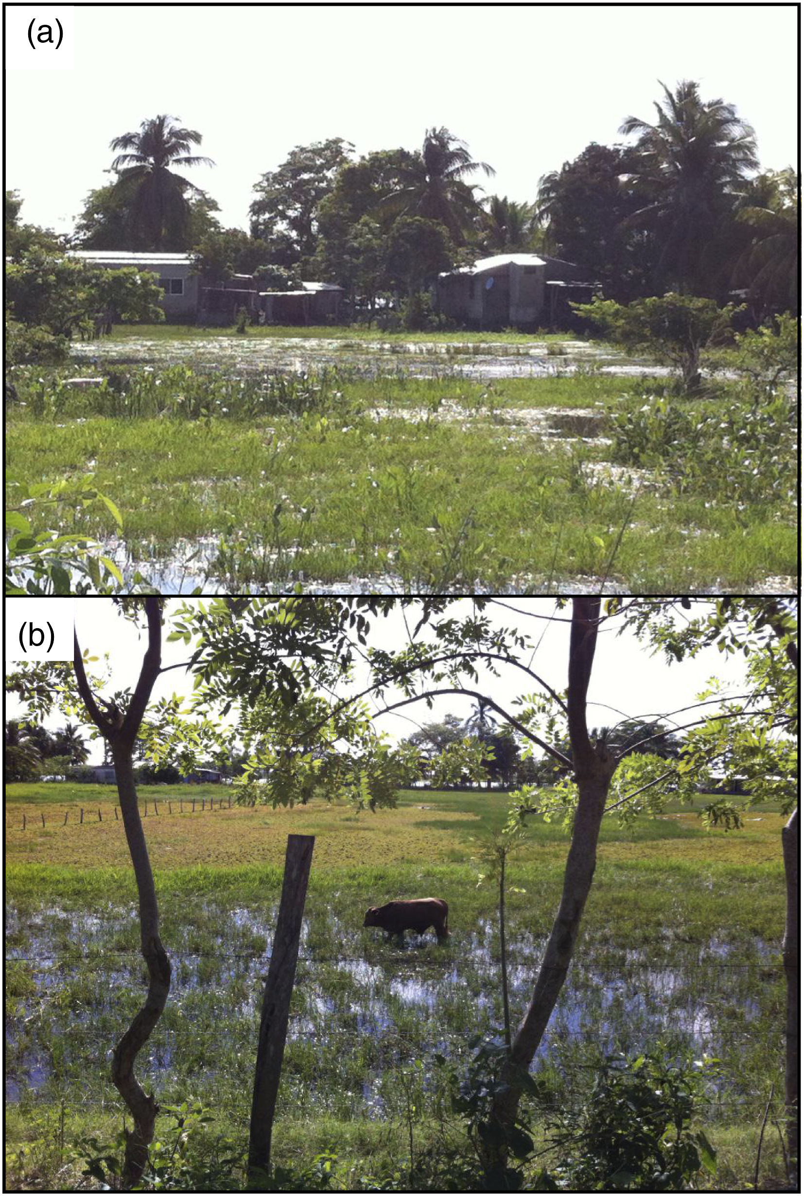
Santos-Reyes et al. (2010) described the most catastrophic flood recorded in the state of Tabasco in recent decades, which left more than 1 million people homeless, caused multiple casualties, and resulted in millions of dollars of damage to infrastructure. Muñoz-Salinas and Castillo (2015) investigated the main cause of the rise of sediment transport and water discharges for the Usumacinta and Grijalva rivers, examining the role played by El Niño-Southern Oscillation (ENSO) and tropical storms. They found that the tropical rainfall and storms associated with the cold phase of ENSO (La Niña), are more important than hurricanes in causing peak sediment and discharge and this may have occurred in the past. For this reason, the Pre-Columbian cultures probably adapted by choosing settlement locations above the fluvial terraces and atop hills, but also modified landscapes with artificial mounds (Ramírez-Núñez et al., 2019).
More broadly, historic floods and avulsions of the Usumacinta and Grijalva Rivers induced major changes in floodplain and delta structure and sources of risk to societies across the region since at least the stabilization of sea-level rise 6–7 ka. A recent example is the city of Villahermosa, the capital of the state of Tabasco. The downtown area of Villahermosa, surrounded by the Carrizal and Mezcalapa Rivers, lies atop the highest local terrain. The effects of La Niña climatic phases and higher precipitation on flooding and geomorphic change are evident in other river basins like the Panuco River in northern Tabasco and Veracruz state (Hudson, 2003; Muñoz-Salinas and Castillo, 2015).
Evolution of the coastline of tabasco and human settlement interactions
The low-lying coastal plains of Tabasco contain a complex system of coastal bars, lagoons, and estuarine environments distributed from the mouth of the Tonalá River (on the boundary between the Mexican states of Veracruz and Tabasco) to the Laguna de Términos (close to the boundary between the Mexican states of Tabasco and Campeche). This complexity is controlled by two factors: (1) lateral shifts in the position of the river mouths of the Usumacinta and Grijalva Rivers since the Pleistocene, and (2) the rise of the sea level in the Gulf of Mexico after the last postglacial marine transgression (West et al., 1969; Psuty, 1967). This coastal environment is rich in nutrients and has extensive mangrove forests, which, in turn, continue to play an important role in regional hydrology and geomorphic evolution (Thom, 1967). These natural resources attracted hunting, fishing, gathering, farming, and navigation around the Gulf of Mexico.
In the Pleistocene, the Grijalva and Usumacinta Rivers flowed into the Gulf of Mexico separately. These rivers had and still have multiple channel bifurcations and delta switching on Tabasco’s coastal plain (West et al., 1969; Psuty, 1965, 1967). The main bifurcations of the Grijalva consisted of an eastward channel migration from the Tonalá River to the Rio Seco River to the San Pedro River. At this point the Usumacinta and Grijalva joined for first time, to the current Usumacinta–Grijalva mouth in the Tabasco Delta (Figure 5). With the Usumacinta River, the river mouth moved from the Palizada River at the Laguna de Términos, to the San Pedro River and to the current mouth in the delta of Tabasco (West et al., 1969). The most recent modification of the Grijalva’s course occurred in 1934 following a partial avulsion of the Grijalva River. This event was due to human activities, for which there are historical precedents of “rompidos” (breaks) (Alatriste Domínguez, 2019) in the Grijalva River channels since the 17th century. Mendoza et al. (2019) described the consequences of the avulsions and the bifurcations of the Samaria River. They calculated the quantity of sediments flowing through the Samaria and the Carrizal distributaries, highlighting the complexity of the sediment discharge in the Grijalva River for the last 50 years. For a better understanding of how the Usumacinta and Grijalva rivers moved to today´s location and to understand preferred settlement by its inhabitants, we performed a simple topographical analysis of situating the main Maya settlements in a long profile extracted from a SRTM DEM across the area, which the next subsection of topographical analyses discusses. Topography and main rivers flowing at the coastal plain of Tabasco. In A is shown the distribution of the beach-dune ridges at the coastal line (yellow lines), together with the location of the Maya settlements (red circles) that are obtained from the website: www.mayamap.org. The base map is from the 30 m resolution ASTER-GDEM obtained from the https://earthdata.nasa.gov/. This map highlights that areas with slightly higher elevation around the coastal plain are (1) between the rivers Tonalá and Rio Seco, old outlets of the Grijalva river, in which deltaic sediments form the areas less prone to inundation and (2) the Palizada River at Laguna de Términos, where the old outlet of Usumacinta River is located. In B, the topographic profile (A to A′) highlights the areas of less elevation around the current outlet of Usumacinta/Grijalva outlet which form a corridor. The arrows indicate the direction of the migration of the Usumacinta and Grijalva rivers since the Pleistocene.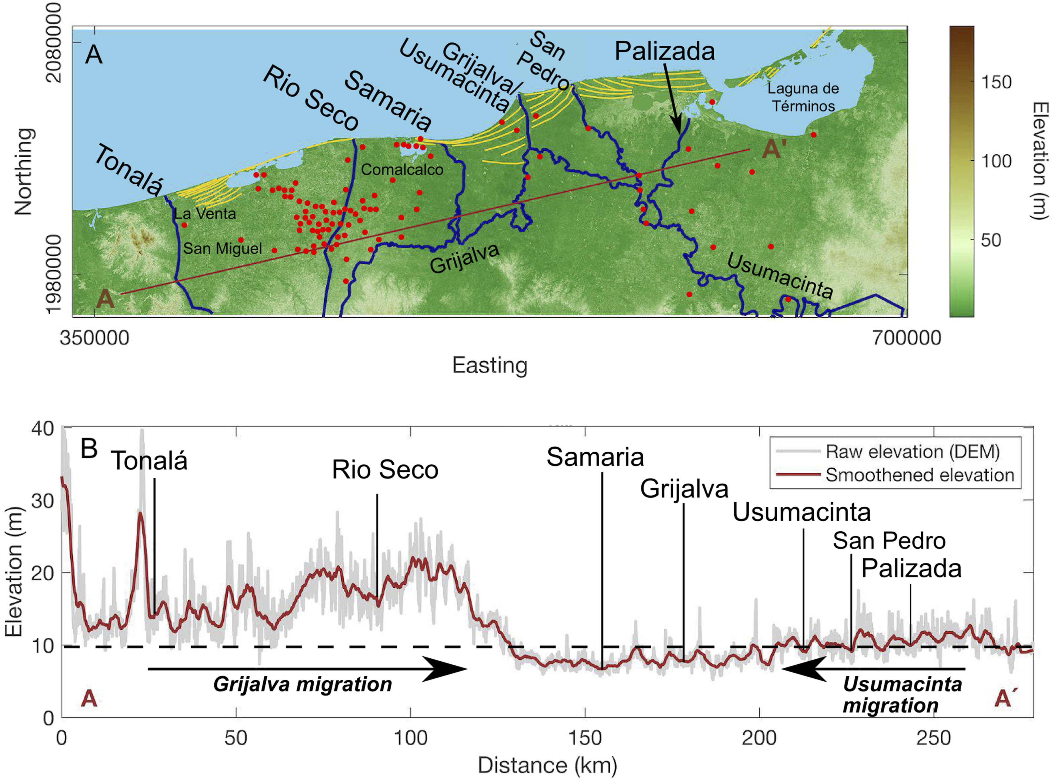
Pope et al. (2001) documented the last postglacial marine transgression in Tabasco’s coastal zone. They analyzed different sediment cores from a lagoon located near the Olmec settlement of San Andrés, close to the Tonalá River mouth (Figure 1). They found that the lagoon formed around 7000 BP when sea level stabilized around the Gulf of Mexico (Balsillie and Donoghue, 2004; Day et al., 2007).
A series of sand bars aligned along the coastal beaches of Tabasco have been forming since the early to mid-Holocene sea-level stabilization (Figure 6). These beach-dune ridges form when the sediment discharged to the sea returns to the coasts by waves and currents and is deposited onshore (Psuty, 1965). The Usumacinta and Grijalva Rivers are the dominant fluvial outlets bringing the catchment’s discharge and sediments to the coast. They have migrated across the delta plain switching from one outlet to another and changing the location of new beach ridges. The abandoned outlets no longer deliver sediment to the coast, which stalls coastal deposition and beach ridge formation, robbing the beach ridges from their fluvial sources and thus waves begin to erode these old beach ridges. On the coastal plain of Tabasco, beach ridges accumulated via the rivers Tonalá, Rio Seco, San Pedro, and Palizada (Laguna de Términos), and they have suffered erosion since they lost their outlet’s sediment discharge. Research on the beach-dune ridges formed along the San Pedro River on the Tabasco coast by Hernández-Santana et al. (2007) used a time series of photographs to estimate an erosion rate is of 8 m yr−1 at the coastline between 1943 and 1995 CE after outlet abandonment. Views of the delta of Tabasco. In A, coastal erosion over beach-dune ridges of San Pedro River generated during the phase 2 of construction of the Usumacinta/Grijalva delta. In B, field with well-conserved beach-dune ridges where swales are inundated, and ridges emerge, the natural vegetation has been anthropically reduced. In C, trees emerge on the drowned area identified in Figure 7(b) in a Google Earth image from 2020.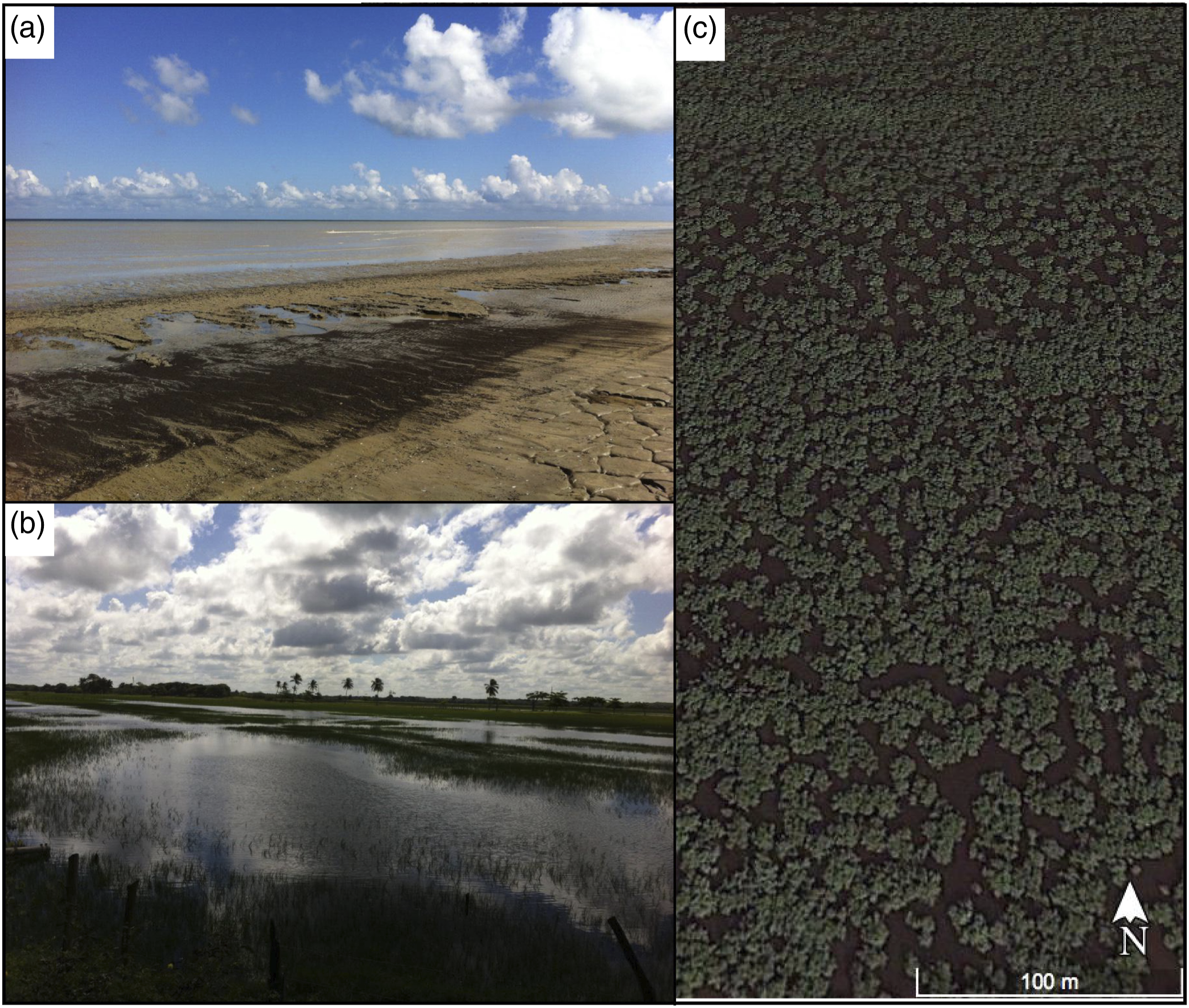
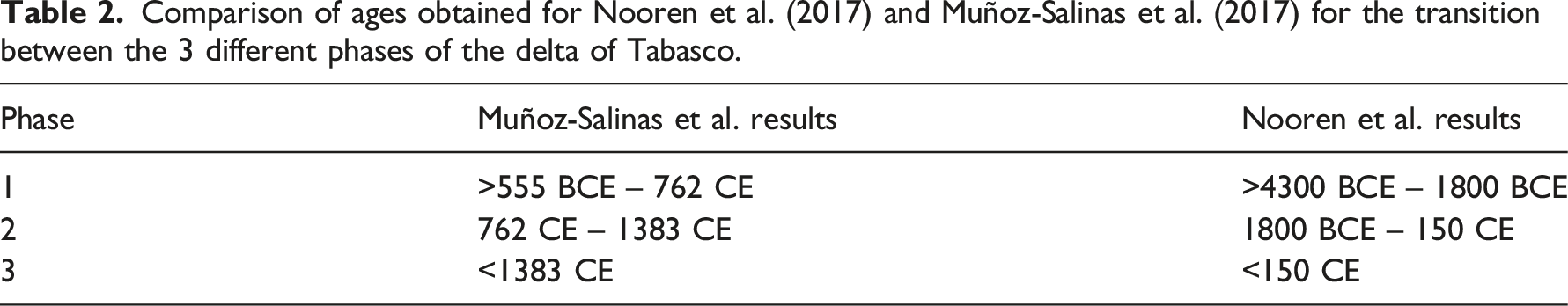
Beach ridge orientation on the Tabasco delta indicates three past changes in the direction of the bars, resulting from geomorphic changes linked to the three bifurcations of the river outlet channels (West et al., 1969; Psuty, 1965; 67; Aguayo et al., 1999; Muñoz-Salinas et al., 2017; Nooren et al., 2017). Phase 1 represents beach-dune ridges located in the inner part of the delta; phase 2 is constituted by sand bars distributed on both sides of the San Pedro River mouth, and phase 3, still in progress, formed the beach ridges on both sides of the current mouth of the Usumacinta–Grijalva outlet (Figure 7(a)). How the evolution of the Tabasco delta relates to the human settlement history is an interesting and unresolved issue. Recent publications about the Tabasco delta provide different geochronologies based on OSL dating. Results of Muñoz-Salinas et al. (2017) indicate that the three-phase Tabasco delta landscape is younger than estimated by Nooren et al. (2017). We present the transitions ages between the three different phases (Table 2). Muñoz-Salinas et al. (2017) showed that the Maya Classic period occurred at the end of Delta phase 1 and beginning of phase 2, c. 1200 BP Geochronolocal model for the three phases of evolution of the strand-plain of Tabasco and main Maya occupation in the delta. In Comparison of ages obtained for Nooren et al. (2017) and Muñoz-Salinas et al. (2017) for the transition between the 3 different phases of the delta of Tabasco.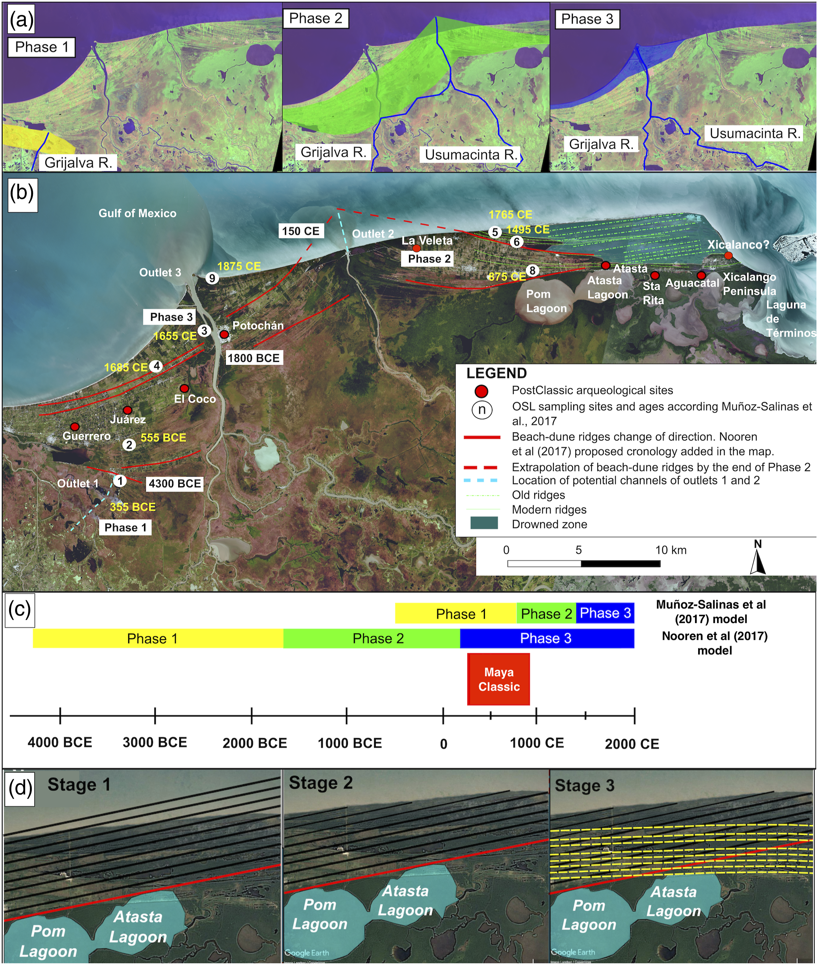
We propose here that if a catastrophic flood occurred during the transition of phase 1 to 2 at 762 CE (1188 BP) as presented by Muñoz-Salinas et al. (2017), this event may have influenced the arrangement of Maya settlements around the lower Usumacinta and Grijalva rivers and the coastal plain of Tabasco. Establishing the chronology of geomorphic evolution in this region has implications for our understanding of early cultural change in the region. Pope et al. (2001), for example, suggested that the development of agriculture in the coastal plain was related to the formation of the beach ridge and lagoon systems due to the presence of soils with suitable drainage and fertility near ample aquatic resources.
Maya settlement and fluvial-deltaic evolution in recent millennia
The archaeology of the coastal delta of the Usumacinta–Grijalva Rivers suggests that the Olmec and Maya (and perhaps other cultures at times) have inhabited the region for about seven millennia (Pope et al., 2001; Gunn et al., 2019b). Contact-era historical records support the notion of a densely occupied coastal zone at the start of the 16th century, with many thousands of Maya settled in a low-lying landscape punctuated with islands of marginally higher terrain. Vegetation was so dense that movement occurred through the myriad of vein-like channels and connected water bodies, as documented in Cortés’ letters on his early encounters with the Maya (Cortés and Gayangos, 1866).
Muñoz-Salinas et al. (2017)’s OSL dating of beach ridges located west of the main channel (sites 3 and 4) (Figure 7) suggest these formed around the 17th century CE (250 BP) during Phase 3 of progradation, likely post-dating the arrival of the Spanish in the early 16th century CE (350 BP). These beach ridges lie c. 1 km (seaward) of a several small Postclassic Maya sites, including Juarez, El Coco, and Guerreros (Figure 1). These Maya sites are likely to have been located near the Postclassic period coastline, and thus coastal progradation since then (including some recent landward erosion) situates them now 5–10 km inland (Figures 1 and 7).
Our comparison of the location and chronology of known pre-Contact sites suggests that the current coastal fringe at the mouth of the Usumacinta, 1–2 km of beach ridges and inter-barrier depressions inland of the present-day coast, is devoid of any known ancient sites. This is best explained by the model of more recent coastal progradation, and that much of the coastal fringe dates to recent centuries, after the Maya period. Munoz-Salinas et al.’s (2017) model suggests that the delta at Phase 2 was building seaward until the Usumacinta–Grijalva moved to the current northern location at outlet 3 in the 14th century (c. 1380 CE; 570 BP). This interpretation is supported by Guevara Chumacero and Pichardo Fragoso (2014) who studied the archaeology and settlement patterns around the Maya site of Centla to the east of the Grijalva River, noting that this same northern region was absent of archaeological sites in their survey. Nooren et al.’s (2017) chronology for these beach ridges places them as much older surfaces (c. 150 CE; 1800 BP), which implies that the delta plain was a well-established terrain more than a millennium earlier. This, in turn, would have provided attractive locations for the Classic and Postclassic Maya to have settled, in addition to (or instead of) those Postclassic locations today found 4+ km further inland.
Importantly, the location and chronology of settlement patterns of the Postclassic Maya sites discussed here (presently located > c. 2 km from the coast) are also easily accommodated within Nooren et al.’s (2017) chronology for the delta’s evolution. Applying Nooren et al.’s chronology here would imply that the beach ridges underlying these Maya settlements had been established for a millennium or more before the settlements were established, but that perhaps the sites in the Postclassic would not have been “waterfront” settlements, but instead located a similar distance from the coastline as they are today. In either case, it can be said the beach ridges and levees were important for pre-Hispanic human settlement. Indeed, in some instances, beach ridges and levees along channels would have been the only suitable landform available for permanent settlements. One such site is Islas de Los Cerros, the Late Classic Port site of Comalcalco, which was built upon a narrow beach ridge that is the only substantial surface topography within a large swath of mangrove swamps (Psuty, 1967; Ensor, 2003). Further support for this model comes from LiDAR-based studies of the broader Tabasco region by Inomata et al. (2021) that found little or no archaeological features in the coastal wetlands and mangrove swamps, only on the beach ridges and levees.
Hinojosa et al. (2016) studied soil chronosequences from across the beach ridge system west of the main channel, showing that soils across the chronosequence had weak pedological development and thus relatively young ages. These beach ridge soils must have had limited use for agriculture for the pre-Contact Maya, but they were a more useful for the rammed earth structures and bricks used at these coastal sites.
For the post-Contact period (after 1518 CE; 432 BP), the geochronological models of the Usumacinta–Grijalva delta reviewed here can be compared with Chávez Jiménez’s (2007) model for the evolution of the Usumacinta–Grijalva delta based on historical map analysis. Chávez Jiménez (2007) estimated that delta progradation has occurred from 1519 to 2000 CE (431-0 BP), extending the mouth of the Grijalva 8–10 km offshore and 20–25 km along the coast, substantially reconfiguring the deltas and bar systems through these centuries. The historical map-based model agrees with the post-Contact delta geochronology of Muñoz-Salinas et al. (2017), with the present-day township of Frontera (considered by some scholars as the approximate location of the important Late Postclassic/Protohistoric site of Pontochán) located on the coastline at the time of Spanish Contact. By contrast, the chronology of Nooren et al. (2017) suggests that the final major phase of coastal progradation had finished by the time of Contact (c. 1500 CE; 450 BP). Further archaeological and chronological research on these less studied minor settlements could reveal further evidence of the geomorphologic and human co-evolution of the coastal plain in the Maya Postclassic.
It is worth examining modern analogs for the type of catastrophic flooding that may have marked the late 8th century CE (1150 BP) delta region. For example, in a 2007 CE flood (Reyes et al. (2004), the coastal bars of the Usumacinta–Grijalva delta acted as a barrier for the evacuation of the water that flooded the coastal plain as beach-dune ridges are up to 3 masl. In 2007 CE, modern machinery was used to pump out the water from the flooded areas, but no such human interventions would have prevailed in the pre-Modern era. This could mean that catastrophic flooding in the pre-Contact historic period could cause an avulsion of the Usumacinta–Grijalva outlet and produce the drowning of large extensions of the coastal plain and river floodplains for several months or even years (Selby, 1985). High-magnitude flooding would readily destroy cultivated fields, inhabited areas, and the complex web of channels across the floodplain swamps and lakes. Mirroring what must have happened for the ancient Maya, Alatriste Dominguez (2019) described how the Samaria River (Figure 1) avulsion of 1932 CE resulted in the inundation of some 20,000 ha of agricultural fields.
In summary, our knowledge of the geomorphic evolution of the floodplain delta region of the lower Usumacinta–Grijalva River system (around a three-phase model of coastal progradation) is now well-established, based on nearly 60 years of scholarship. More recent research has provided the much-needed chronological framework to understand the delta floodplain evolution. In contrast, much is still unknown about the region’s human history, including the chronology and nature of many Maya sites. The human history of the Usumacinta–Grijalva delta for the Maya Classic period (3rd to 8th century CE; 1650-1150 BP) is perhaps the least understood. But based on the archaeology published to date, we propose a pattern of human settlement that is time-transgressive across the delta, with Classic (and earlier) Maya settlement concentrated further away from the modern coast on the periphery of the active beach-dune ridge field (Comalco, Jonuta, and further south, Palenque; or immediately adjacent to the older beach ridges on palaeoshorelines, such as the Xicalango Peninsula), with a Postclassic Maya settlement focused on locations on the floodplain deltas that extended to European contact (e.g., La Veleta). The Xicalango Peninsula contains numerous pre-Contact settlements and it remains unclear which of these may have been the ancient settlement of Xicalango. In this paper, we use the location given for “Xicalango” as recorded by the Mayamaps.org project, on the far eastern side of the Xicalango Peninsula (see also Ruz Lhuillier, 1969).
It is important to stress that these are only a small selection of the many locations of past settlements recorded across the coastal region of the lower Usumacinta–Grijalva River Basin. Jiménez Valdéz (1987), for example, details 45 or more pre-Contact sites between the right bank of the San Pedro River and the western shore of Laguna del Términos (the Xicalango Peninsula), an area of c. 600 km2, with evidence of widespread occupation by the Maya prior to Contact (see also Guevara Chumacero and Pichardo Fragoso (2014)). Advances in remote sensing of the Maya lowlands (e.g., Lidar topographic survey) are expanding not just the number of pre-Hispanic settlements in our records, but also the timing and nature of human settlement and agriculture in the region (Beach et al., 2019; Dunning et al., 2020; Inomata et al., 2020, 2021). Pairing this settlement work with field and dating campaigns (Beach et al., 2019) and new findings on the archaeology of the southwestern corner of the Maya lowlands in Tabasco and Campeche will clarify the temporal and spatial connections between cultural groups (Inomata et al., 2021) and continue to refine our understanding of the long human history of this region.
Exploring relationships between past human settlement and landscape accessibility along the tabasco coastal plain using topographical analyses
We performed two different topographical analyses in the floodplain of Tabasco. The first one consisted of visualizing Maya sites of the coastal plain of Tabasco on an elevation map (Figure 5). On this map we infer that Maya settlements in the area are located above the depressed zones of the terrain. We observe that most of the Maya sites are located along the delta of Rio Seco, which contains the highest elevations around the coastal plain of Tabasco (over 10 m asl). Maya settlements avoided areas prone to floods, which correspond to the lowest elevations, though some sites may have been buried and eroded and thus not mapped. The lowest elevations in the coastal plain of Tabasco are located around the current delta of the Usumacinta–Grijalva Rivers. Elevation here explains why the Usumacinta and Grijalva Rivers have progressively switched to this sector to flow together into the sea, first through the San Pedro River and later to the current Usumacinta–Grijalva outlet (Figure 5). Elsewhere on the coastal plain of Tabasco, the old Usumacinta outlets lie along the southeast of Laguna de Términos. This sector contains less elevated grounds compared to the topography of Tonalá and Rio Seco outlets; however, these elevations are higher than those of the margins and floodplain of the lower course of the Usumacinta–Grijalva rivers (Figure 5). North of Laguna de Términos in the zone of benign flooding, Dunning et al. (2020) documented the largest-known complex of artificial canals for this region near the Maya site of Acalán. These imply a sophisticated, pre-Contact hydraulic infrastructure, probably used for farming, fishing, and transportation.
The second topographical analysis was located at the Laguna Pom–Atasta, located at the inner sector of the strand-plain of Tabasco between the San Pedro-San Pablo outlet and the Laguna de Terminos. For this sector we propose an evolutionary geomorphic model. The location and chronology of several pre-Contact sites were compared to the early and later phases of the beach-ridge chronology of Muñoz-Salinas et al. (2017). The OSL dating of an older (further inland) period of beach ridge construction (adjacent to the northern shoreline of the Laguna Pom–Atasta) provided a calendar year of 875 CE ± 30 (1075 ± 30 BP; see Figure 7, sample number 8). A relatively small Maya site, Atasta, lies c. 13 km further east along the line of beach ridges that Muñoz-Salinas et al. (2017) estimated had formed in the late 9th century CE (1050 BP). Importantly, the OSL-based geochronology here constrains the earliest possible settlement of Atasta to the end of the Terminal Classic Period, while artifacts are Postclassic (Berlin, 1956) and Protohistoric (Ball and Rovner, 1972). In this case, the beach ridges where Atasta was established may have been geomorphically active a century before construction and permanent settlement. Using the beach ridge OSL chronology to inform the settlement history, Atasta was probably established near the end of Maya Terminal Classic or early Postclassic period. The beach ridges on the northern shore of Laguna Atasta represent the current barrier between the water body and other inter-barrier swamps and lakes and the ocean to the north. However, the laguna (or an earlier version of it) is thought to predate this barrier, with the antecedent laguna forming after the mid-Holocene in response to sea-level rise stablization and the onset of beach ridge formation from the palaeo-Usumacinta, whose mouth was further east towards Laguna de Terminos (Figure 7(b) and (d)). The ancient settlement of La Veleta is also located on an area of beach ridges constructed during Phase 2 of our model (Figure 7, location from Jiménez Valdéz (1987). La Veleta has a history of occupation from the Late Postclassic (c. 1250 CE) through to Contact (Fox, 1987), post-dating the estimated phase of dune ridge construction from our model.
The beach ridges on the northern shore of Laguna Pom, which is the lagoon connected to Laguna Atasta to the west, seem to be much older, probably contemporaneous with (and causing) the formation of the lagoons during the mid-Holocene, as described by Gutiérrez-Estrada et al. (1982). Based on the earlier findings of Gutierrez-Estrada et al. (1982) and our analysis and interpretation of the LiDAR-based DEM and Landsat imagery for the coastal plain, we propose a new model for the evolution of the eastern sector of the delta plain that includes the formation and evolution of the large Laguna Pom and Atasta water bodies (see Figure 7(b) and (d)).
We have identified evidence of older beach dunes preserved that have not been eroded or buried by the beach ridges formed by San Pedro River sediment during the Phase 2 (Figure 7(b) and (d)). The former bars have an orientation seaward to the barrier of Laguna de Términos and their age is unknown. Beach ridges close to Isla del Carmen, however, have radiocarbon ages of 400-300 BCE (2350-2250 BP) on the oldest dunes (Thom, 1967), and it is reasonable to assume that old bars of the eastern sector of the Tabasco delta should have broadly similar ages. These bars point to an old delta of the Usumacinta River with its lobe located at the coastal barrier of Laguna de Términos. It is most probable that these bars were closing the lagoons of Laguna Pom–Atasta during their formation (see Figure 7(b) and (d)). The beach ridges pointing to the lobe of the San Pablo River formed during phase 2 of the Usumacinta–Grijalva delta formation. The age of these recent ridges overlapping the old bars should be around 875 ± 30 CE (1075 ± 30 BP) according to Muñoz-Salinas et al., 2017) (Figure 7(b); sample number 8).
For new sand bars to interdigitate with existing ones, we assume a local marine transgression provoked this overlapping of the new ridges over the oldest (Figure 7(b) and (d)). This seems to be the case of these areas based on two lines of evidence: (1) the front part of the eastern lagoon seems to have been reshaped from deposition of the oldest beach ridges of Phase 2 (see Stage 3 in Figure 7(b) and (c)), and (2) most of the area from the Laguna Pom–Atasta to the current coastal line is submerged (Figures 6(c) and 8(a) and (b)). This underwater condition prevailed for enough time to prevent settlements in the area and Landsat images show no human occupation or disturbance other than modern oil pipelines. The LiDAR topographic model does not show particularly lower elevations in this sunken area, which is suggested by the satellite images of dense mangrove forest that emerge over the water, especially at the crests (Figures 6(c) and 8(a), (b)). The extent of well-developed vegetation over beach ridges provides some support for the notion that the area is formed on old sand bars. Nooren et al. (2017) identified compaction and subsidence of the inner sector of the current deltaic lobe of the Tabasco delta, and Gutierrez-Estrada et al. (1982) recognized compaction of the oldest beach ridges found at the Pom–Atasta lagoons. It is reasonable, therefore, that compaction of the oldest bars of this eastern and distal sector of the delta occurred in part due to the marine transgression of this area, which led to the deposition of the beach ridges of Phase 2. This is feasible because ridges form during storms that produce high waves that can easily overtop canopies of the drowned trees. These new ridges have continuity to Punta Xicalango, where there is the Maya site of Aguacatal, near the western shore of Laguna de Términos.
Aguacatal has a site chronology, based on ceramic sequences and several (imprecise) radiocarbon dates, that suggests human settlement started in the Late Preclassic period and continued through to the Late Postclassic (Matheny, 1970: 117–121). Aguacatal lies c. 1 km south of the oldest beach ridges from Phase 2, situated atop the older, southernmost beach ridges from the palaeo-Usumacinta (Figure 8). Accordingly, the archaeology and chronology of Aguacatal (c. 2000 BP) may be considered a terminus ad quem for the initial formation of the earlier beach ridge system associated with the mid-Holocene San Pedro distributary avulsion of the Usumacinta, sometime after 6–7 ka BP. Some evidence that this may be the case comes from the degree of pedogenesis of sand deposits underlying Aguacatal. Houston et al. (2005) discusses this site’s Late Preclassic and later chronology, and we note a similar soil pedogenesis to that of Hinojosa et al.’s (2016) early phase (4500 BP) further northwest on the coastal plain. Hinajoso et al. (2016) show the older soils in the coastal plain formed from 4500 to 5100 BP based on the development of more yellowish-brown color, increased organic matter and clay, more stable structure, and changes in extracted Fe.
Conclusions
In this paper we synthesized and contextualized the available fluvial geomorphological publications on the lower Usumacinta–Grijalva River Basin in a framework of four millennia of Maya, and other cultural, settlements. Our starting point is that the lower Usumacinta–Grijalva River Basin was very attractive for human settlement because it contained extraordinary biodiversity, rich fluvial soils, dense tropical forests and mangroves, and diverse biota. Additionally, the lower Usumacinta–Grijalva River Basin is not affected by the water scarcity experienced in other places, such as the Maya ceremonial centers in karstic environments or the elevation interior region (EIR) high above the water table (Luzzadder-Beach et al., 2016). The major risk for Maya settlements in the Usumacinta Basin were floods and sediment discharge, resulting in fluvial geomorphic forms that, in some cases, were already constituted when the Maya appeared in the lower Usumacinta–Grijalva River Basin and continued developing during the ancient Maya period. Among those important geomorphological units developed before Maya settlement are the Plio-Pleistocene to Holocene terraces along the Usumacinta and Grijalva floodplains and proximal coastal plain. The most important ceremonial centers developed on those: such as Palenque, Tierra Blanca, Balancan, Vicente Guerrero, El Pochote, and Aguada Fénix along the Usumacinta River and Comalcalco, and the Olmec settlement of La Venta, in the Grijalva. All these sites were in the highest and most stable parts of the landscape, avoiding the potentially hazardous flood zones. Along the low-lying coastal plains of Tabasco, the Usumacinta and Grijalva Rivers flowed into the Gulf of Mexico separately until they joined together to form the Usumacinta–Grijalva delta. There are two geochronological models for the evolution of this delta, which formed during three phases that coincide with different locations of the delta´s mouth. The ages provided by these models have implications for how the evolution of this delta affected ancient Maya settlements. We contend that both geochronological models accommodate Pre-Columbian human settlement in the delta. The Munoz-Salinas et al. (2017) model discussed here has important implications for settlement patterns and chronology. First, this model positions the transition of stage 1–2 at ca. 750 CE (1200 BP), the Late Classic period, and catastrophic flooding could have affected the local ancient Maya people in this stage area. Second, the Munoz-Salinas et al. (2017) model explains why there are no known ancient Maya sites along the surface of the delta constructed during the most recent phase, which initiated by the end of the 14th century, during the Maya Late Postclassic and close to European contact and population collapse. Our topographical interpretation of the distal sector of the Usumacinta–Grijalva delta, at the Pom–Atasta lagoons, showed that the most recent development phase of the delta should have occurred very close to the present time, in agreement with the model that positioned the starting point of the most recent stage of the delta in the 14th century. This new analysis of Laguna Pom–Atasta allowed us to propose a mechanism for late Holocene geomorphic evolution and land use of this distal sector of the delta, and the pre-delta located at the Laguna de Términos.
Footnotes
Declaration of conflicting interests
The author(s) declared no potential conflicts of interest with respect to the research, authorship, and/or publication of this article.
Funding
This work was partially supported by the National Geographic Society Committee for Research and Exploration (7506-03, 7861-05), Australian Research Council Discovery Project (DP180101986), National Science Foundation (0924501, 0924510, 1114947, 1550204).