
Abstract
Linear, incised and usually an order of magnitude wider than the Martian valleys, the Martian outflow channels are scoured ground commonly displaying streamlined remnants of the pre-existing terrain. A recent study used an unprecedented dataset of the Martian valley networks to propose that most of the valley networks are a result of combined surface and subglacial runoff. This also prompts to revisit One of the earliest hypotheses that the ancient ice streams might have carved the Martian outflow channels. With an exceptional focus on Mars exploration planned during the next decades, it is important to assess the regional-scale geomorphic processes to better target the future landing and sample return missions.
I Introduction
Studying and understanding the Martian cryosphere has always been an important aspect of our solar system research and exploration (Galofre et al., 2021; Smith et al., 2021). During 1972, the Mariner 9 mission captured ∼85% of the Martian terrain at 100 m–1 km per pixel resolution, and the spotting of apparent water-worn valleys changed our perception of Mars as a perpetually cold and dry planet (Carr, 2007). Two types of such large, linear and incised features observed in the Mariner images were the outflow channels and the valley networks. While the Martian outflow channels are tens to hundreds of kilometres across without any tributaries, the valley networks have tributaries and are much narrower, typically only 1–5 km across. Sharp and Malin (1975) used the term ‘outflow channels’ for the first time to distinguish them from the smaller valley networks. Although initially, several alternative formation hypotheses such as erosion by lava, liquid CO2, hydrocarbons, glaciation and huge mass movements were proposed, soon the similarity of the channels and valleys to terrestrial water-carved landforms and the discovery of evaporites suggested that Mars had probably been warmer and wetter in its geological history (Carr, 2007). However, while liquid water has been presumed as the main sculptor of the Martian valleys and channels, there are several other contemporary perspectives on the possible formation mechanisms for these landforms; glaciation being a prominent one of them (e.g. Galofre et al., 2020; Lucchitta, 2001).
While the Martian valley networks have mostly been believed to be a result of slow erosion by water streams (Carr, 2007), a recent study by Galofre et al. (2020) provides a new perspective to this debate and proposes that most of the Martian valley networks are a result of combined surface and subglacial runoff. Galofre et al. (2020) used an unprecedented data of Martian valley networks compiled by Hynek et al. (2010) and studied six parameters, that is, junction angle between tributaries and main stem, streamline fractal dimension, maximum network stream order, width of first-order tributaries, length-to-width aspect ratio and magnitude of longitudinal profile reversals. The collective morphological statistics of the valley networks and a quantitative classification into physical models of the four erosion processes (i.e. fluvial, glacial, sapping and subglacial erosion) suggested subglacial incision to be the most predominant factor in carving out the studied Martian valleys (Galofre et al., 2020). Their results suggest that ancient Mars might not have been as warmer and wetter as previously thought. Galofre et al.’s (2020) results are also in accordance with the modelled cooler climate during the Late Noachian Icy Highlands (LNIH) period that puts a serious constraint on the more popular interpretations of the geological record requiring precipitation and surface water runoff to form the valley networks. Although another study (Palumbo et al., 2018) suggested that there was still some seasonal melting during the LNIH, in which massive amounts of ice melted and flowed across the surface, creating river valleys.
Galofre et al.’s (2020) findings can have similar implications for the outflow channels on Mars, vastly believed to be formed by large floods and resulting rapid erosion. This prompted us to revisit the earliest hypothesis by Lucchitta et al. (1981) that the ancient ice streams might have carved the Martian outflow channels. Dr Baerbel Kösters Lucchitta is one of the first women astrogeologists who pioneered in proposing the plausible role of ancient ice streams in carving Martian outflow channels through several of her follow-up papers (e.g. Lucchitta, 1982, 2001). Considering that leading space agencies and space companies are investing significant resources in enabling further Mars exploration within next couple of decades, it is important to (re)assess the regional-scale geomorphic processes and better target the future landing and sample return missions. The vast influx of orbiter and rover observations in the past two and half decades has significantly facilitated our understanding of the Martian atmosphere, terrain and subsurface (e.g. Bhardwaj et al., 2017, 2019a, 2019b, 2019c; Sam et al., 2021) and can further help in revaluating the earlier hypotheses concerning Martian geomorphology. Following the concise format of the ‘Classics Revisited’ section of the journal, this article is not intended to prove or disprove Dr Lucchitta’s views on the formation mechanism of Martian outflow channels. Instead, here we aim to emphasise the ice stream hypothesis presented in Lucchitta et al. (1981) and her follow-up works in light of some recent findings and provide a fresh perspective to the debate of how Martian outflow channels might have been formed. We have provided several key references throughout this article which interested readers can further explore to understand the advances on this topic.
II Dr Baerbel Kösters Lucchitta: A short biography
Baerbel Kösters Lucchitta (Figure 1) was born on the 2nd of October 1938 in Münster, Germany. As a Fullbright Scholar, she earned her B.S. degree (Geology) in 1961 from Kent State University in Geology, and her M.S. degree in 1963 from Pennsylvania State University. She received her PhD in Geology, in 1966, at Pennsylvania State University, subsequently working at Astrogeology Science Center as a planetary geologist. From 1995 to 2003, she has also contributed as an adjunct faculty member at Northern Arizona University. She is widely recognised for producing the 1:50,000 geologic map of the Taurus-Littrow Valley site, the landing site for Apollo 17 mission, the last lunar landing of the Apollo Program. The interesting story behind this mapping can be read at the United States Geological Survey (USGS) webpage (https://www.usgs.gov/news/dynamic-career-launched-map). Dr Lucchitta is a Scientist Emerita at the Astrogeology Science Center of the USGS and is widely regarded as one of the first women in the field of Astrogeology. Dr Lucchitta worked extensively on the Valles Marineris region of Mars and has done substantial research on glacial flow and other ice-related features. Most of her career was dedicated to geological studies of the Moon, Mars, Europa and other Galilean moons and Antarctica. Dr Lucchitta in the Cinder Field with a model of the lunar vehicle in fall of 1972 before the Apollo 17 mission. Credit: U.S. Geological Survey (https://www.usgs.gov/media/images/dr-baerbel-lucchitta-during-apollo-days).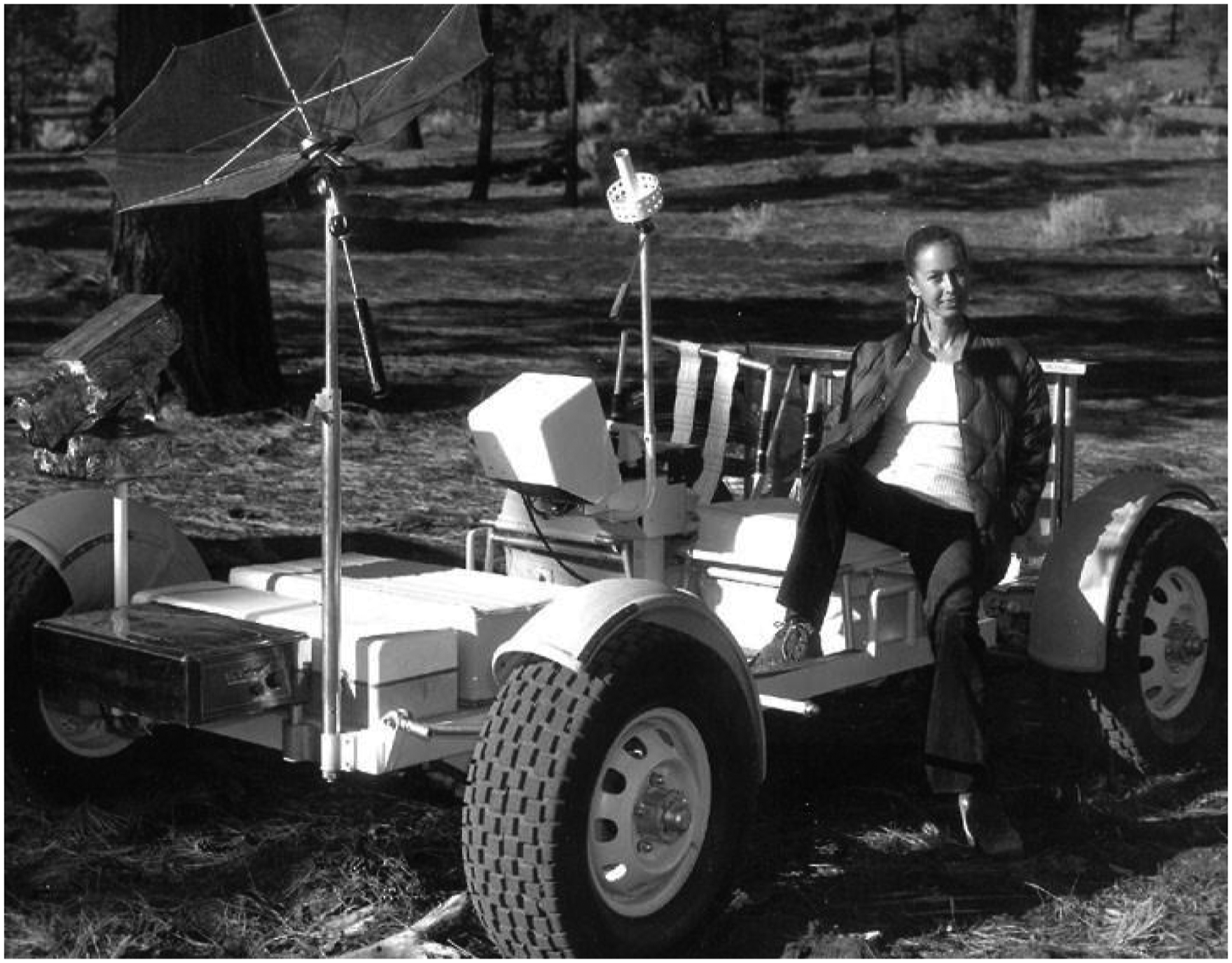
Throughout her inspiring career, Dr Lucchitta has received several prestigious recognitions and awards. In 1979, on the 10th anniversary of the first lunar landing, the group that Dr Lucchitta was a part of received NASA Special Recognition Group Award. She is also a recipient of USGS Special Achievement Award (1983) and U.S. Department of the Interior Meritorious Service Award (1994). In 1995, Dr Lucchitta received G. K. Gilbert Award for the Planetary Geology Division, Geological Society of America. In 1996, she was named the Centennial Fellow in Department of Earth and Mineral Sciences, Pennsylvania State University. Given her significant contribution to planetary glaciology research, the Lucchitta Glacier in Antarctica is named after her. The Asteroid 4569 Baerbel is also named after her, recognising her contribution to planetary geology. Most recently, Dr Lucchitta has been recognised among the top 2% scientists in the world, for her contribution to the field of Astrogeology (Ioannidis et al., 2020).
III Martian outflow channels
Martian outflow channels have widely varying dimensions with the widths differing between less than 1 km across for several of them and over 400 km across for Kasei Vallis, the largest outflow channel (Carr, 2007). Using the data from the recent global geological mapping of Mars (Tanaka et al., 2014), we have presented the global distribution of major Martian outflow channels in Figure 2. Interested readers can find further contextual geomorphic information in the geomorphologic map provided by Bhardwaj et al. (2021), modified from the geological map by Tanaka et al. (2014). Owing to their several characteristics typical of large terrestrial floods, the widely accepted hypothesis is that large ancient floods carved the outflow channels (e.g. Andrews-Hanna and Phillips, 2007; Baker, 1978, 1981; Baker and Milton, 1974). These characteristics are the low sinuosity and high width-depth ratios, streamlined walls, teardrop-shaped islands, longitudinal striae, plucked zones and inner channels on the valley floor (Carr, 2007). However, there are several points related to the flood hypothesis which still need more justification and investigation. For example, the source of the sudden huge volume of flood water is a mystery and multiple flooding events and subsurface cryosphere-confined aquifers have been suggested as additional sources of water (e.g. Coleman, 2003; Harrison and Grimm, 2008). The absence of large ice bodies as marked flood accumulation zones at the ends of the channels is also perplexing (Carr, 2007). The presence of outflow channels in various geological and climatic settings further indicates the possibility of multiple formation mechanisms. Several other such mechanisms in literature refer to tension fracturing (Schumm, 1974), erosion by glaciers (e.g. Lucchitta, 1982, 2001), wind (Cutts and Blasius, 1979), lava (e.g. Leverington, 2004, 2011; Schonfeld, 1976), liquid CO2 (Lambert and Chamberlain, 1978) and liquid alkanes (Yung and Pinto, 1978), while CO2- (e.g. Hoffman, 2000) or water-supported (e.g. Tanaka, 1999) debris flows are other proposed formation mechanisms. A difficulty in establishing any or a combination of these as the formation mechanism arises from the extensive post-formation modification of channel walls and floors by aeolian processes, cratering, thermokarst, sapping, slumping, rilling and debris/talus flows, thus obscuring the signals of the primary formation mechanism (Baker, 1981). This also points to a possibility that the present cross-section of an outflow channel is not necessarily the same as the initial one (Baker, 1981). Global distribution of major Martian outflow channels (data source: Tanaka et al., 2014). The background image is Mars Orbiter Laser Altimeter (MOLA)-derived topography (MOLA data courtesy: NASA/JPL/Goddard).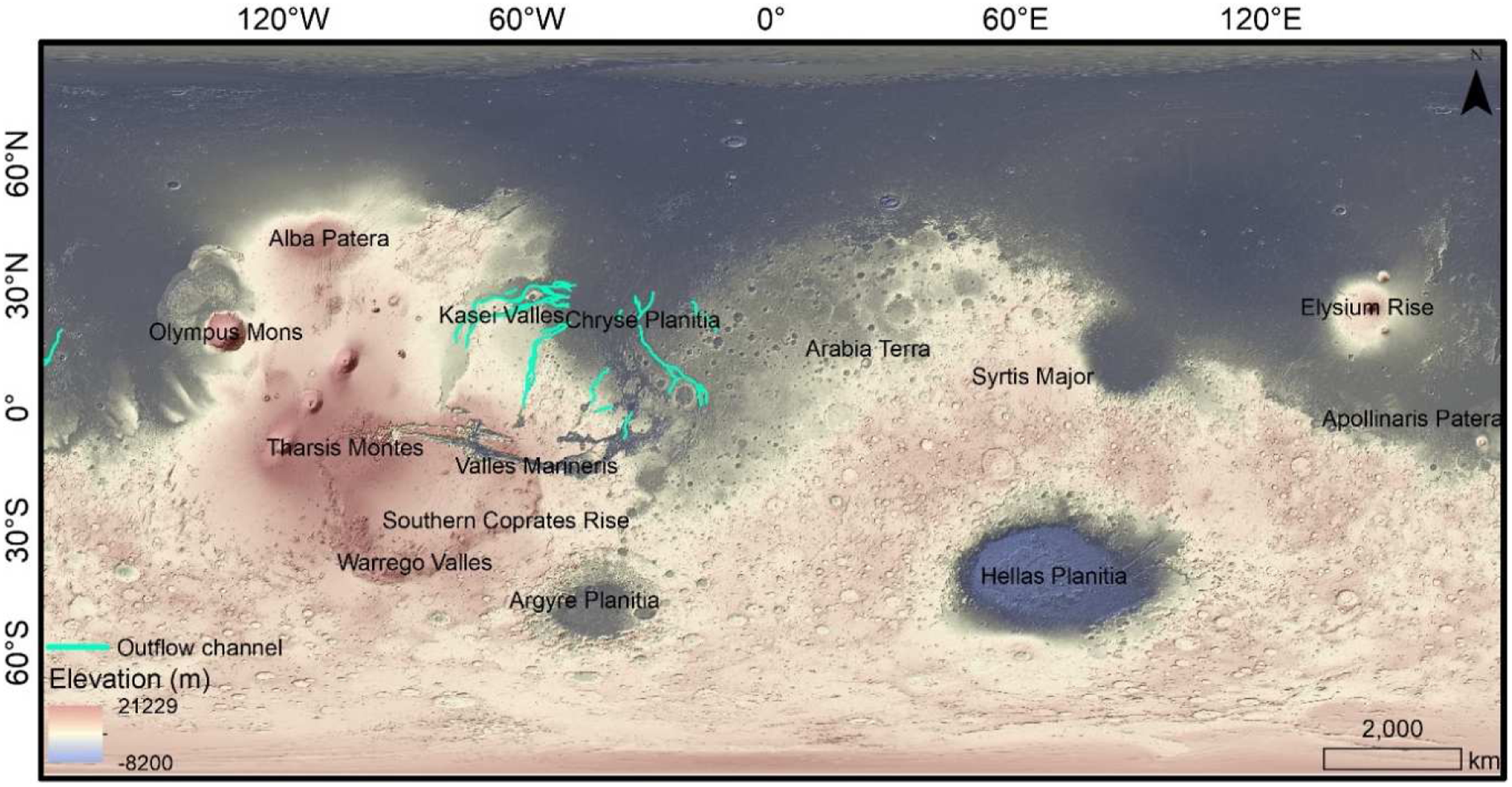
IV Lucchitta’s hypothesis and her follow-up works on Martian outflow channels
The title of Lucchitta et al.’s (1981) paper was, ‘Did ice streams carve Martian outflow channels?’ and was published in the journal Nature. This was the first such substantial work which provided several arguments in favour of glaciation as the forming mechanism for Martian outflow channels. Over the next decades, this work was extended and well-supported by several other papers by Lucchitta (e.g. Lucchitta, 1982, 2001). Lucchitta et al. (1981) adopted a comparative glaciology approach to draw analogy from erosional characteristics and the resultant landforms created by glaciation on Earth for defining the origin of Martian outflow channels. In order to facilitate the comparative study, Luchitta et al. (1981) opted for a classic geomorphologic approach while comparing the terrestrial and Martian glacial landscapes. They interpreted valley cross-sections (U-shaped vs. V-shaped); they studied ridges and grooves on valley floors; they calculated length-to-width ratios and they further compared periglacial landscapes. Lucchitta et al. (1981) start their argument by highlighting the morphological analogies between Martian outflow channels and terrestrial ice streams. While often deeply incised like their terrestrial counterparts, Martian outflow channels expand, constrict and anastomose around the teardrop-shaped islands too, in the same fashion as the Antarctic ice streams flow and anastomose around ice rises (Lucchitta et al., 1981; Lucchitta, 1982, 2001). Lucchitta et al. (1981) extend this analogy to incised glacial valleys in Yosemite Park in California and in fjords in northern Canada, Greenland and Scandinavia. Moreover, Lucchitta et al. (1981) highlight the presence of long even scour marks, hanging valleys and longitudinal grooves along the Martian outflow channels, and the U-shaped cross-sectional profile of the constricted regions of the channels as the features typical of terrestrial glacial environments.
By then, several of Baker’s papers (e.g. Baker, 1978, 1981; Baker and Milton, 1974) had proposed teardrop-shaped streamlined islands on the floor of outflow channels as a crucial marker of catastrophic flooding owing to their analogy with the scablands of Washington State. Lucchitta et al. (1981) proposed an analogy between these teardrop-shaped Martian islands and the ice rises in Antarctica, presently being sculptured by active ice streams. They plotted their dimensions on the graphs presented in Baker’s papers and found that the Antarctic ice rises lie on the same trendline as the scabland and Martian islands. Moreover, Lucchitta et al. (1981) also compared the elongation (length-to-width ratio) of the islands and found that the average elongation of Antarctic ice rises was 2.5, closer to average elongation of 2.7 for Kasei Vallis islands, compared to an average elongation of ∼3.5 for the scabland islands. Providing further dimensional analogy, Lucchitta et al. (1981) compared widths of grooved terrain in Kasei Vallis and the grooved terrain of Laurentide ice sheets in the Northwest Territories of Canada and reported them to be similar, that is, ∼180 km. Along the same lines, Lucchitta et al. (1981) reported the dimensional similarities between the scarp heights of the Martian channels and the terrestrial glacial scarps in Antarctic and Icelandic ice streams. Even the reported Antarctic ice sheet surface gradients range from 0.10° to 0.25°, comparable to the gradients of Martian channel beds (Lucchitta et al., 1981). Lucchitta et al. (1981) also provided some perspectives on the possible flow mechanism and sources of these Martian ice streams, with atmospheric precipitation, wind-drifted frost and dust deposits, and ground springs being the prominent ones. Thus, Lucchitta et al. (1981) provided remarkable geomorphologic evidence in support of their ice stream hypothesis, suggesting ice sculpturing as another probable process responsible for the formation of Martian outflow channels.
Lucchitta (1982) followed up Lucchitta et al.’s (1981) paper and used even more of the comparable satellite images to provide a detailed account of the geomorphological analogies and the ice stream hypothesis. In particular, Lucchitta (1982) investigated the possibility of whether ice could have moved in the past Martian environment. The slopes of the outflow channels on Mars are extremely low or even reversed at several places, and therefore, a certain thickness of ice is required to initiate glacial motion (Lucchitta, 1982). Lucchitta (1982) proved that an ice-fill in the Martian channels to the level of interior plateaus could have been sufficient to enable the flow even under the present cold climatic conditions. This flow could have been easier in the presumably warmer climates of the ancient Mars, and even more prominent if the channel fluids were brines, enabling basal flow. Lucchitta (2001) was another prominent follow-up work in this direction, where contemporary Sound Navigation and Ranging (SONAR) data of the Antarctic sea floor was used to establish morphological analogy between terrestrial mega-scale glacial lineations and longitudinal flutes in Martian outflow channels. This analogy was remarkable as it suggested that the ice in Martian channels might have moved like Antarctic ice streams on deformable debris saturated with water under high pore pressure (Lucchitta, 2001). However, based on this new analogy, another major inference by Lucchitta (2001) in a way reconciled with the mega-flood hypothesis for outflow channel formations. A major constraint for the mega-flood hypothesis has always been the elusive source of the sudden release of massive volumes of water on the ancient Mars. Lucchitta (2001) proposed that if ice or ice-rich debris locally shaped the Martian channels and gave rise to mega flutes and streamlined forms, catastrophic floods which were one-to-two orders of magnitude larger than those on Earth (Baker, 1979) were not needed. Instead, much smaller floods or rivers could have readily emerged and would have flown locally in frozen form on the deformable debris within the outflow channels in the same manner as the Antractic ice stream.
V Perspectives
In the following years, this notion proposed by Lucchitta (2001) further grew that the Martian outflow channels could be a possible outcome of both, fluvial and glacial/subglacial sculpting processes. Pacifici et al. (2009) presented a detailed account of Ares Vallis Complex, one of the longest and ancient of the Martian outflow channels. Ares Vallis originates from Iani Chaos, extending a further 1500 km across Noachian and Early Hesperian cratered plateaus, finally spreading out in Chryse Planitia (Pacifici et al., 2009). While geomorphic features such as grooved erosional terraces, pendant bars, streamlined uplands, and cataract-like features in Ares Vallis are attributed to temporal flooding, other features such as probable kames, thermokarstic depressions, and patterned terrains are suggestive of past ice-masses (Pacifici et al., 2009). However, the ice-masses proposed by Pacifici et al. (2009) corresponded to dead ice and not a flowing ice stream as proposed by Lucchitta (1982, 2001). Pacifici et al.’s (2009) model was based on a plausible cyclic relationship between the catastrophic floods and dead ice-masses, where, multiple subglacial catastrophic floods occurred, followed by grounding of ice-masses and emplacement of ice-contact deposits, finally leading to ice wasting through sublimation.
Rodríguez et al. (2014) used crater-counting to further establish that the southern circum-Chryse outflow channels were locally resurfaced by some of the most recent catastrophic floods coexisting within regional glacier environments on Mars, as recently as during the Middle Amazonian (1.23–0.328 billion years ago (Ga)). Rodríguez et al. (2014) linked their chronology during the Middle Amazonian with the cyclic relationship between the catastrophic floods and dead ice-masses as proposed by Pacifici et al. (2009). Rodríguez et al. (2014) suggested that sublimation as proposed by Pacifici et al. (2009) was not the only ice wasting process, but the Middle Amazonian climate warming might have further led to the melting and flow of ancient relict ice. Head et al. (2005) provided evidence for glaciation at tropical latitudes connected with episodes of climate change during the Late Amazonian. This highlights the Amazonian as an era of extremely cold and dry long periods interrupted by short-duration climatic warming that allowed for glacier formation, in combination with significant meltwater production, suitable for enabling the formation of the Martian outflow channels (Rodríguez et al., 2014). In a follow-up work, Rodriguez et al. (2015) proposed that contrary to previous belief, most of the outflow channels might have been formed during the Early (3.37–1.23 Ga) and Middle (1.23–0.328 Ga) Amazonian, and not during the Late Hesperian (3.61–3.37 Ga), furthering the evidence for plausible cyclic glacial and fluvial events as proposed by Pacifici et al. (2009).
Recently, Galofre et al.’s (2020) findings proposed similar multiple formation processes for the Martian valley networks with subglacial and fluvial erosion being the predominant mechanisms during 3.9–3.5 Ga. Galofre et al. (2020) proposed mainly two evidences in support of the subglacial incision forming valley networks: (1) morphological, and (2) hydrological. Much like Lucchitta et al. (1981) and her other follow-up works (e.g. Lucchitta, 1982, 2001) on analogy between terrestrial ice streams and Martian outflow channels, Galofre et al. (2020) also proposed remarkable geomorphologic analogy between terrestrial subglacial channels and Martian valley networks. However, the even more interesting hydrological argument presented by Galofre et al. (2020) was based on the spatial distribution of classified valley networks with respect to the models of a LNIH ice sheet (Fastook and Head, 2015). The Majority of the characterised subglacial valley networks are located between the equilibrium and terminus lines of a LNIH ice sheet, suggesting the significant role of subglacial melting and flow in carving the valley networks below the equilibrium line (Galofre et al., 2020). Thus, Galofre et al. (2020) hypothesise a mostly cold-based ice sheet with localised basal melting as the most likely scenario to trigger subglacial valley network incision without the challenges related to rainfall and aquifer replenishment.
Considering that the formation period of the majority of the outflow channels has now been constrained between colder Early (3.37–1.23 Ga) and Middle (1.23–0.328 Ga) Amazonian (Rodriguez et al., 2015), the aquifer replenishment source to promote periodic mega-floods is even more challenging to explain. Another notable point is the presence of nearly all the outflow channels within the equilibrium and terminus lines of a LNIH ice sheet, presented by Galofre et al. (2020). An ice stream corresponds to a region of fast-moving ice within an ice sheet, and the colder Late Hesperian and Amazonian climates could have promoted the formation of far smaller (than the Noachian) but basally fluidised ice sheets than LNIH ice sheets, below the LNIH ice sheet equilibrium line. Viscous flow features (VFFs) on Mars represent all glacial-type formations displaying evidence of viscous flow (Souness et al., 2012) and are majorly characterised into lobate debris aprons (LDA), lineated valley fill (LVF), concentric crater fill (CCF) and glacier-like forms (GLF) (Bhardwaj et al., 2016; Bhardwaj and Martin-Torres, 2016; Sam et al., 2021). VFFs are considered as an important proxy for understanding the glaciation and climate change throughout the Amazonian (Brough et al., 2019). VFFs’ contemporary presence is thus attributed to the ice being protected from sublimation by surface debris (Fastook et al., 2014) and Koutnik and Pathare (2021) have recently investigated the analogy of LDA and GLF with terrestrial debris-covered glaciers. While a holistic inventory of all the VFFs is still not available, in Figure 3, we have plotted an updated GLF distribution (Brough et al., 2019) alongside the Martian outflow channels. Although the GLFs clearly mark the Late Noachian ice sheet margin (Galofre et al., 2020), they are remarkably absent from the regions closer to the Martian outflow channels. This can probably be explained by the movements in Amazonian ice streams carving these channels, and avoiding stagnancy in the ice flow and any significant supraglacial debris deposition. This might have further led to the gradual and complete disappearance of the remnants of the ice streams through sublimation, leaving behind a trail of subglacial landforms which Lucchitta observed, studied and described in her papers (Lucchitta et al., 1981; Lucchitta, 1982, 2001). Regional distribution of Glacier-like Forms (Data source: Brough et al., 2019). The background image is Mars Orbiter Laser Altimeter (MOLA)-derived hillshade (MOLA data courtesy: NASA/JPL/Goddard).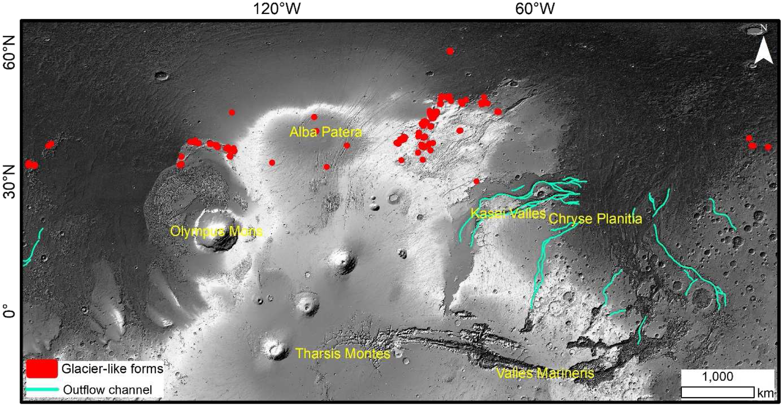
VI Summary
During all these advances in our understanding of the geomorphology and formation constraints on the Martian outflow channels, Lucchitta’s works have certainly been pioneering in proposing glacial/subglacial processes as one of the carving agents. This provided the follow-up workers with another plausible mechanism which could possibly contribute to the formation of at least several of the outflow channels, either on its own or in conjugation with the fluvial processes. This case of Martian outflow channels also reaffirms the possibility that many other enigmatic Martian surface features (e.g. Bhardwaj et al., 2019a, 2019b, 2019c) could also have been formed by multiple geomorphic agents and we should opt for a holistic viewpoint while investigating their geomorphology. With nearly the entire Martian terrain covered at ∼6 m/pixel Context Camera (CTX) resolution, and continuously increasing volume of submeter High Resolution Imaging Science Experiment (HiRISE) images and terrain models, certainly the prospects for performing wide-ranging high-resolution geomorphic analyses have significantly improved. The coming decades are going to be even more exciting in terms of improving our understanding of Mars with planned orbiter, rover and Mars sample return missions, making it even more important to assess and target the regional-scale geomorphic processes.
Footnotes
Acknowledgements
The authors acknowledge the encouragement, helpful suggestions and support from Prof. David R. Butler.
Declaration of conflicting interests
The author(s) declared no potential conflicts of interest with respect to the research, authorship, and/or publication of this article.
Funding
The author(s) received no financial support for the research, authorship, and/or publication of this article.