
Abstract
The current study aims to portray the specific weather patterns associated with hail falls in north-eastern Romania. This was done using multiple hail records data covering a long period of time (1981–2020). COST733 software enabled us to assess objectively the atmospheric circulation classification types for the middle troposphere (500 hPa) and also for the ground level (sea level pressure) over the study region. Based on these, we have identified 5 major weather patterns (MPs) which explain up to 85% of the recorded hail events over the region. In terms of wind vector direction and speed, driving the hailstorm cells, these MPs are represented by two main groups of synoptic patterns. The first one is characterized by weak advective patterns (cut-off lows, north-easterly anticyclonic flow), while the second one is characterized by strong advective patterns (westerly, south-westerly, and north-westerly atmospheric flows). Further, these major patterns are split into 16 combined circulation types (CCTs), as indicated by the atmospheric circulation at the ground level. Our analysis showed that in May and June hailstorms are determined especially by weak advective patterns over north-eastern Romania, while from June to August the strong advective patterns are more common for these extreme weather events. The atmospheric environment associated with these synoptic conditions, as indicated by instability parameters, is also described using a series of atmospheric parameters: sea pressure level, 500 hPa geopotential field, 700 hPa wind vector, and precipitation amount at the continental scale. This analysis indicates that hail occurs in a regional atmospheric environment characterized by a MUCAPE >500 J/kg and high wind shear in the lower troposphere. The results obtained are meant to become a useful tool in regional hail forecast.
Keywords
1. Introduction
Hailstorms are among the weather extremes that cause the most substantial damages to buildings, crops, and vehicles. For example, a unique hailstorm event from 28 of June 2006 in Germany led to economic losses of approximately 250 million euros (Kunz and Puskeiler, 2010). Similarly, in Romania, in recent years there have been hailstorms that caused great damage, especially to crops. For instance, the storms of 30 of May 2013 in southeastern Romania caused an estimated damage of 2 million euros (Cică et al., 2015), while the storm on 18 of June 2016 in the northeast of the country caused damage of approximately 14 million euros (Istrate et al., 2019). Nowadays the complexity of the hailstorms economic impact is increasing since a number of studies indicate that some regions around the world face an increase of the hail occurrence mostly in connection with climate change (Sanchez et al., 2017; Tang et al., 2019). Although, other studies show that trends in hail occurrence are not significant (Punge and Kunz, 2016).
Regardless of its regional trends, hail represents one of the most extreme weather phenomena determined by the severe convective storms (Hoeppe, 2016). Therefore, improving the capacity to forecast this extreme weather phenomenon represents one of the main available tools for the mitigation of its impact. While the meteorological complexity of the hailstorms still limits the possibilities for its accurate spatio-temporal forecast, nowadays the synoptic climatology enables us to understand the atmospheric environment favorable for its occurrence.
At a European scale, studies analyzing the synoptic background favorable for hailfall occurrence have been undertaken using various methods. These methods combined expert knowledge with the description of the atmospheric instability, especially using thresholds of different indices (Costa et al., 2001; Sioutas and Flocaset, 2003; Simeonov and Georgiev, 2003). Costa et al. (2001) identified two types of synoptic patterns associated with hail days for northern Italy, represented by north-westerly cyclonic circulation and convective development during the early stages of cyclogenesis in the area of the Gulf of Genoa. Sioutas and Flocaset (2003) concluded that in the north of Greece (1976–2001), the most favorable synoptic conditions for hail occurrence are represented by south-westerly flow and short-wave troughs, both patterns being associated with an intense cold advection in the middle of the troposphere above the region. Likewise, Michaelides et al. (2008) found an upper level trough as being specific for hail occurrence during the warm semester in Cyprus. Several studies also indicate that it is ideal to approach the problem of hail storm prediction through a combination between mesoscale characteristics, status of convective parameters, and assimilation of radar data (Makitov and Barekova, 2007; Kunz et al., 2009; Merino et al., 2013; García-Ortega et al., 2014).
For Romania, Burcea et al. (2016) identified a relationship between the variability of the number of hail days and the frequency of low-pressure centers of Atlantic origins acting in Mediterranean region. It was also found that the monthly number of convective systems in the eastern side of Romania is positively correlated with negative anomalies in sea level pressure over the Black Sea (Burcea et al., 2019). Additionally, over the entire north-eastern Romania the north-westerly and north-easterly advections in lower troposphere have been found to be associated with convective developments (Ilie et al., 2020). As mechanism of convective developments leading also to hail, convergence at the ground is also known to play a very important role (Stan-Sion and Antonescu, 2006). In this regard, the cut-off lows and the long-wave troughs—inducing strong convergence at the ground level—were identified as the main causes for convective developments during the warm semester in Romania (Dobri et al., 2017).
The understanding of the synoptic background favorable for hailfall occurrence has advanced through the use of objective classification of atmospheric circulation, enabling the possibility to integrate a higher number of thermodynamic variables into analysis (Huth, 1996, 2000; Huth et al., 2008; James, 2006, 2007; Stohl and Scheifinger, 1994). The use of reanalyzes datasets by applying different types of statistical methods, such as the Principal Component Analysis and Cluster Analysis, lead to a clearer image of conditions favorable to hail occurrence.
Through these approaches, the large scale mechanisms reigning over the continent have been accurately described. For instance, it was proven that the blocking centers located over the north Atlantic and Europe induce a hail prone atmospheric environment over northern France and Germany (Mohr et al., 2019). Similarly, 9 types of atmospheric circulations associated with hailfall were identified in Catalonia (Aran et al., 2011), highlighting the role of a very low pressure field inducing a negative pressure anomaly at 500 hPa in the west of the Iberian Peninsula in the occurrence of this meteorological hazard (García-Ortega et al., 2011, 2014; Merino et al., 2019). Actually, most of the studies focusing on western Europe showed that hail is associated with negative pressure anomalies in these regions (Kolendowicz et al., 2017; Sanchez et al., 2017) in connection with strong warm ridges in the eastern part of the continent.
The current study is meant to enlarge the knowledge on the synoptic background associated to hail occurrence in north-eastern Romania by using the results of two objective atmospheric circulation classification. Through this, some major weather patterns are identified and their general synoptic features are outlined in order to serve as a tool for understanding the atmospheric conditions favorable to hail occurrence, which can also improve the capacity to forecast this extreme weather phenomenon.
2. Data and methods
2.1. Study area and hail climatology
The study area represents the north-eastern part of Romania (Figure 1(a)), corresponding with the western part of Moldova historical region (Figure 1(b)). The analyzed region is situated at the outer part of the Eastern Carpathians and the major landforms consist in a sub-mountain strip in the West, peaking at 1000 m, a hilly plateau region in the central-eastern part, and two plain regions in the north-eastern and south-eastern parts with altitudes below 100 m (Figure 1(b)). We excluded the mountainous region due to the fact that, despite the very high number of days with hail recorded here (Burcea et al., 2016; Sandu et al., 2008), the characteristics of land use (Figure 1(c)) determine a very low vulnerability of this region to hailfall, the area being covered mostly by forests (Popovici et al., 2013; Rusu et al., 2020). Moreover, a lack of data concerning hailfall constrains the possibilities for a proper scientific investigation in this area. Geographical position of north-eastern Romania at continental (a) and country (b) scale; the main land use categories according to 2018 Corine Land Cover (c); the share of hail falls on the main land use categories (d).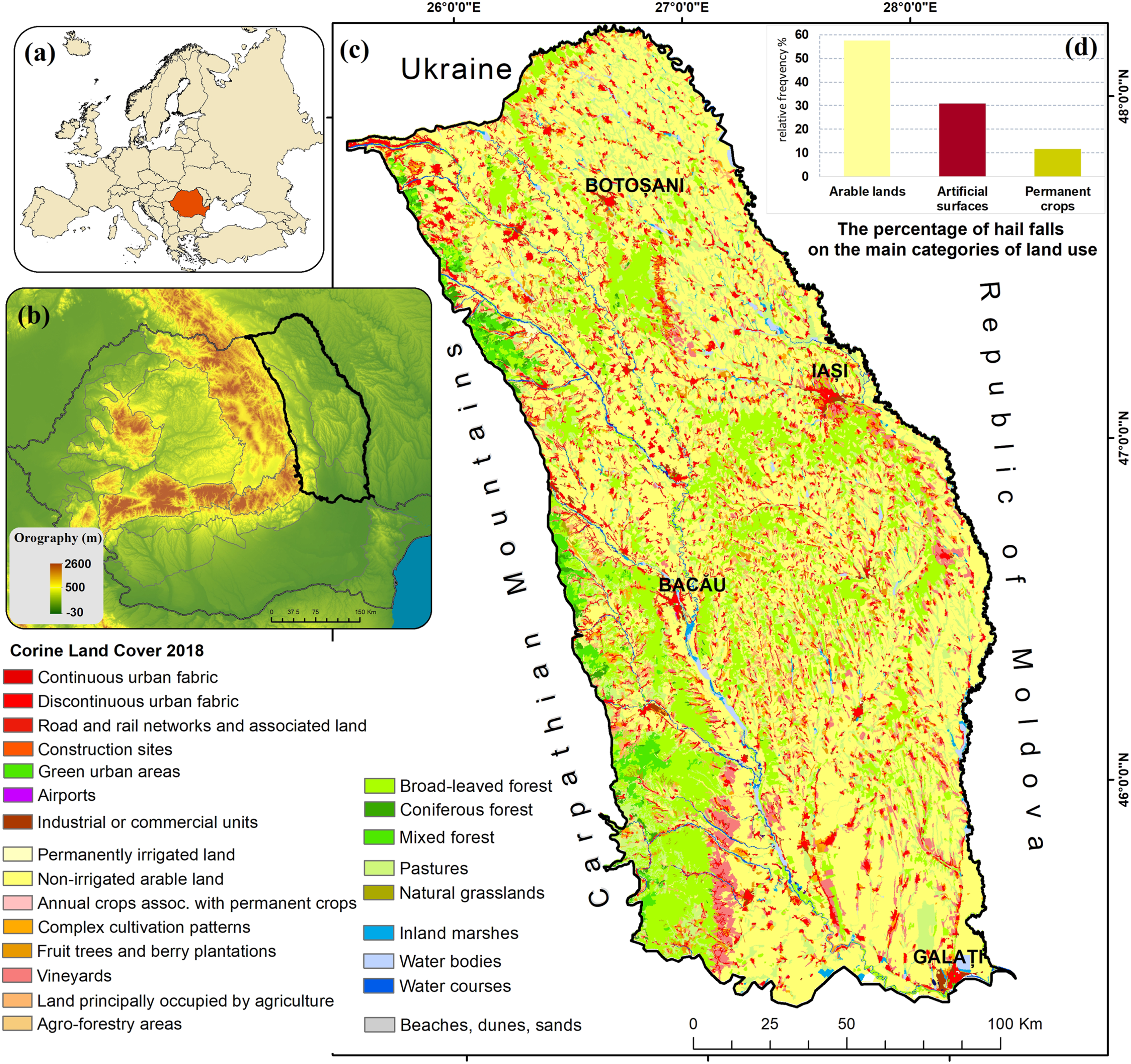
Due to its geographical position within the European continent, the region is sheltered in its western part by the Eastern Carpathians, which induce a series of dynamical peculiarities in regional atmospheric circulation, the Carpathian chain representing an extremely important natural climatic boundary in the region (Apostol and Sfîcă, 2013). Moreover, the major lines of the landforms reflected directly in land use categories (Figures 1(c) and (d)) are oriented from North to South, except for the central and northern parts where a cuesta system is oriented from West to East. This general orientation is very favorable to generate orographic ascension during various types of easterly atmospheric circulations.
The most recent hail climatology for the Romanian territory (Burcea et al., 2016), based on a series of data coming from 105 weather stations (1961–2014), indicate the north-east of Romania as having an intermediate hail day frequency (6–9 days per year). The hail events prevail during April–September (94% of the total mean monthly hail days), reaching the maximum in June (Figure 2(a)). The majority of hail events (78%) occur in the afternoon and evening hours, between 10:00 and 18:00 UTC, while the rest of the hail events (22%) occur in the interval 19:00–10:00 UTC (Figure 2(b)). Using ESWD hail reports for Romania (Istrate et al., 2017), some areas with higher densities are observed, such as the north-eastern and the north-western parts of the country or the Carpathian Curvature area (Figure 2(c)). Spatial distribution of the mean hail days per year (a), monthly distribution of the hail events (b), and hourly distribution of the hail events (c) for 1981–2020.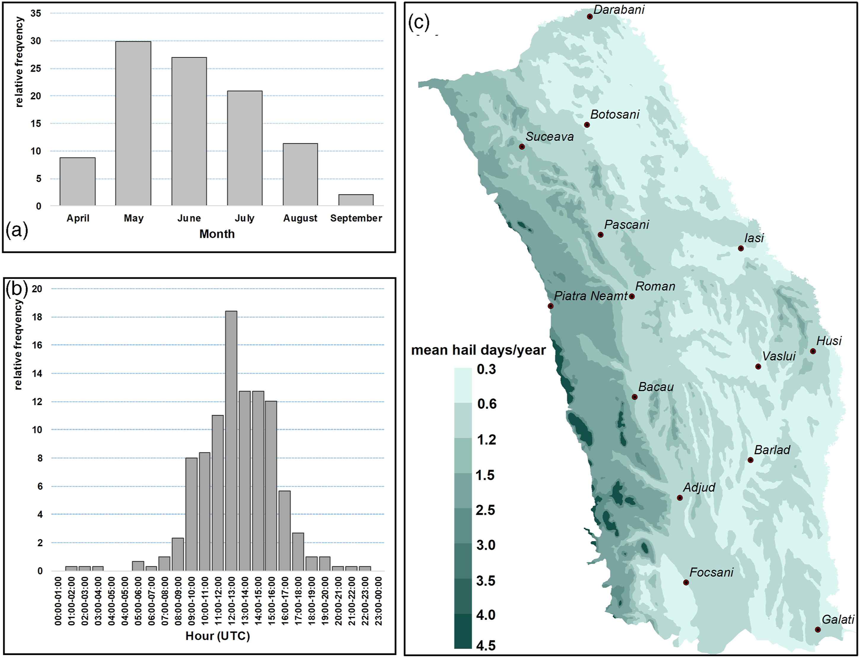
For the extra-Carpathian territory, in the study region, high frequencies of hail days were recorded in the western areas, then on the west-east hills from the north and central parts. High frequencies were also found near some urban centers (Apostol and Machidon 2011; Machidon and Apostol, 2011). The trend analysis of mean number of hail days per year at 15 weather stations from Moldova region during 1961–2014 reveals a statistically significant upward trend only for 8 stations and no significant trend for the rest of the weather stations (Burcea et al., 2016).
2.2. Hail data
The hailfall data were concatenated from three different sources: official weather stations of National Meteorological Administration (NMA), European Severe Weather Database (ESWD) and also from media or ancillary data sources (newspaper reports, social media reports).
The data package from the NMA sums up a number of 242 hail days (hail days) between 1981 and 2017 from 18 weather stations uniformly distributed over the studied region (Figure 3). Spatial distribution of hail records collected from official weather observations, ESWD database and ancillary data between 1981 and 2020.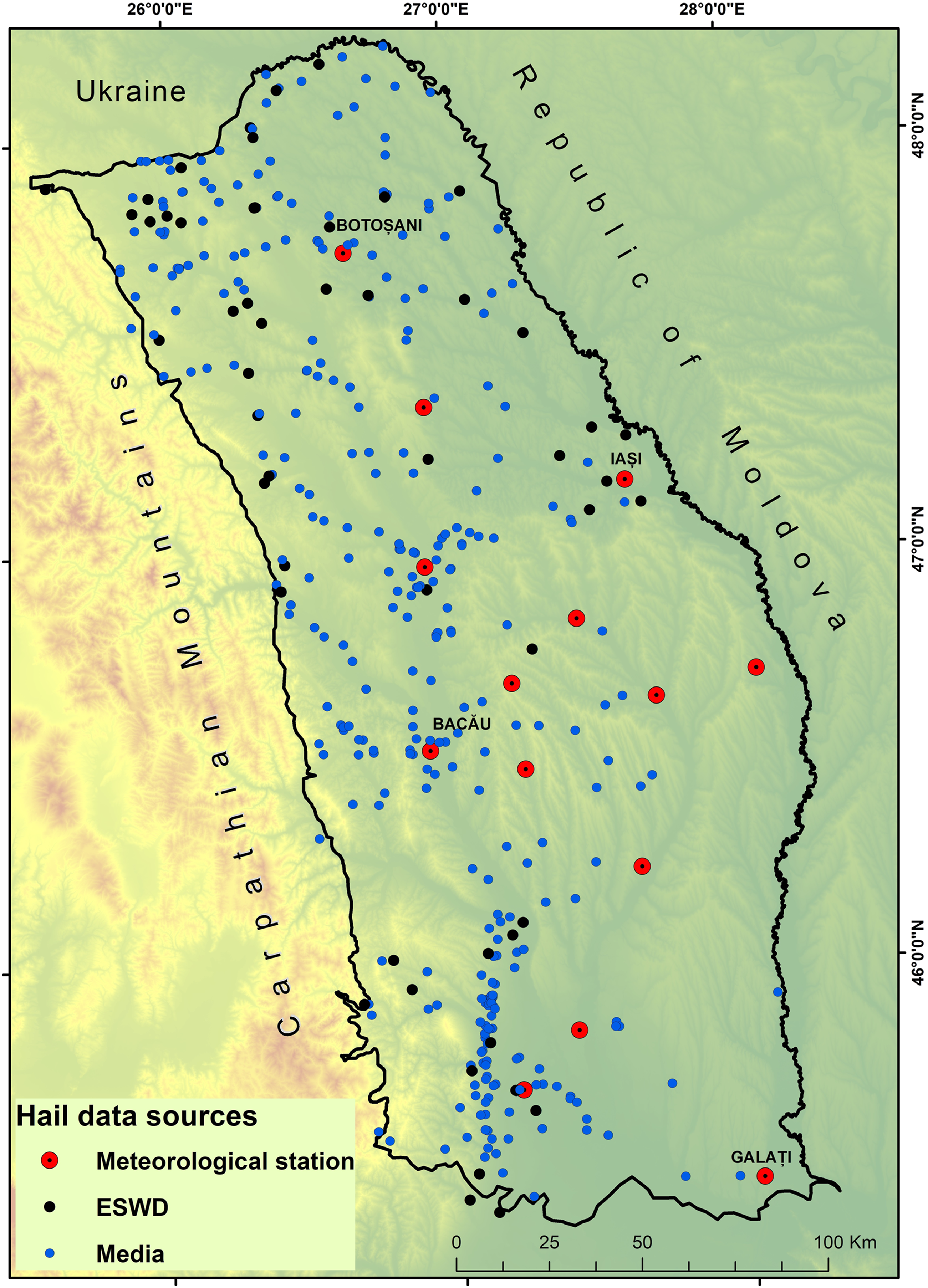
Reports regarding hailfall received from European Severe Weather Database (ESWD) cover the interval 2007–2020. The main objective of ESWD is to collect information regarding weather hazards in Europe, information which subsequently undergo a process of quality control (Groenemeijer et al., 2004, 2017). ESWD uses a homogeneous data format and web-based, multi-lingual user-interfaces where both the collaborating European national meteorological, hydrological services and the public can contribute and retrieve observations (Dotzek et al., 2009). There are numerous studies using data received via ESWD, both on a continental scale (Púčik et al., 2019; Punge et al., 2017; Taszarek et al., 2020a, 2020b) and at a regional level (Dotzek and Forster, 2011). The number of reported weather events with a potential risk is greatly influenced by the phase of evolution of the ESWD network. For the Romanian territory, 40 to 50 reports of hailfall were recorded during the first years (2007–2010), and their number increased in recent years (Istrate et al., 2017). From this database, only the data with a high level of credibility, assessed as QC1 (confirmed report), have been used. This way, a total of 29 hail days was added to the previous dataset from NMA.
The third source was represented by reports of the damaged caused by hailfall from the archive of local newspapers. These types of observations of weather phenomena, including those from past centuries, were used in studies for different climatology studies (Añel et al., 2017; Cheval et al., 2021; Munro and Fowler, 2014). These data went through a process of validation by using the images from the meteorological radars and values of instability indices derived from sounding station for the corresponding days. Those recordings for which no radio locational cells with hail potential were identified were eliminated from the analysis. A total of 86 hail days were identified in this way.
For hail days occurring in multiple locations, one single event was taken into consideration. After qualitative and quantitative analyses, a total of 357 days with hailfall resulted over the studied region (Figure 3), representing a mean of 8.9 events per year.
2.3. Atmospheric circulation classifications
The assessment of atmospheric circulation types was based on the results obtained using cost733 software (Philipp et al., 2010, 2016). The atmospheric circulation types were assessed using two major circulation classification methods implemented in this software. These methods were chosen in order to describe both the synoptic conditions prevailing over the middle troposphere (500–700 hPa), and also those at sea pressure level.
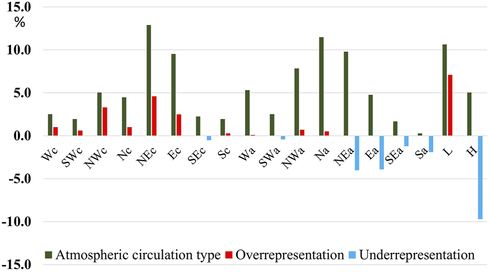
In order to assess the atmospheric circulation patterns in the middle troposphere, we chose the Wetter Lage Klassifikation (WLK) method, which requires as input data the U and V-components of the wind at 700 hPa, and the 500 hPa geopotential height. The atmospheric circulation types are defined according to the dominant wind sector at 700 hPa, and the degree of cyclonicity/anticyclonicity at 500 hPa, which is derived from the mean of quasi-geostrophic vorticity (Bissolli and Dittmann, 2003; Philipp et al., 2010). A weighting mask was applied to the input fields, with higher weights on central grid points. This method classifies the wind field in six main wind sector types, with an additional undefined type when no majority is found, being further discriminated by the degree of cyclonicity, resulting in 14 atmospheric circulation types. The levels of 700 hPa and 500 hPa were chosen since they are regularly used by forecasters to identify the horizontal movement of the convective systems (Corfidi, 2003). Actually, due to this feature, we considered this classification as the base for our final classification of the hailfall days (Figure 4). WLK atmospheric circulation types derived using COST733 software and their relative frequency for April-October (1981–2020).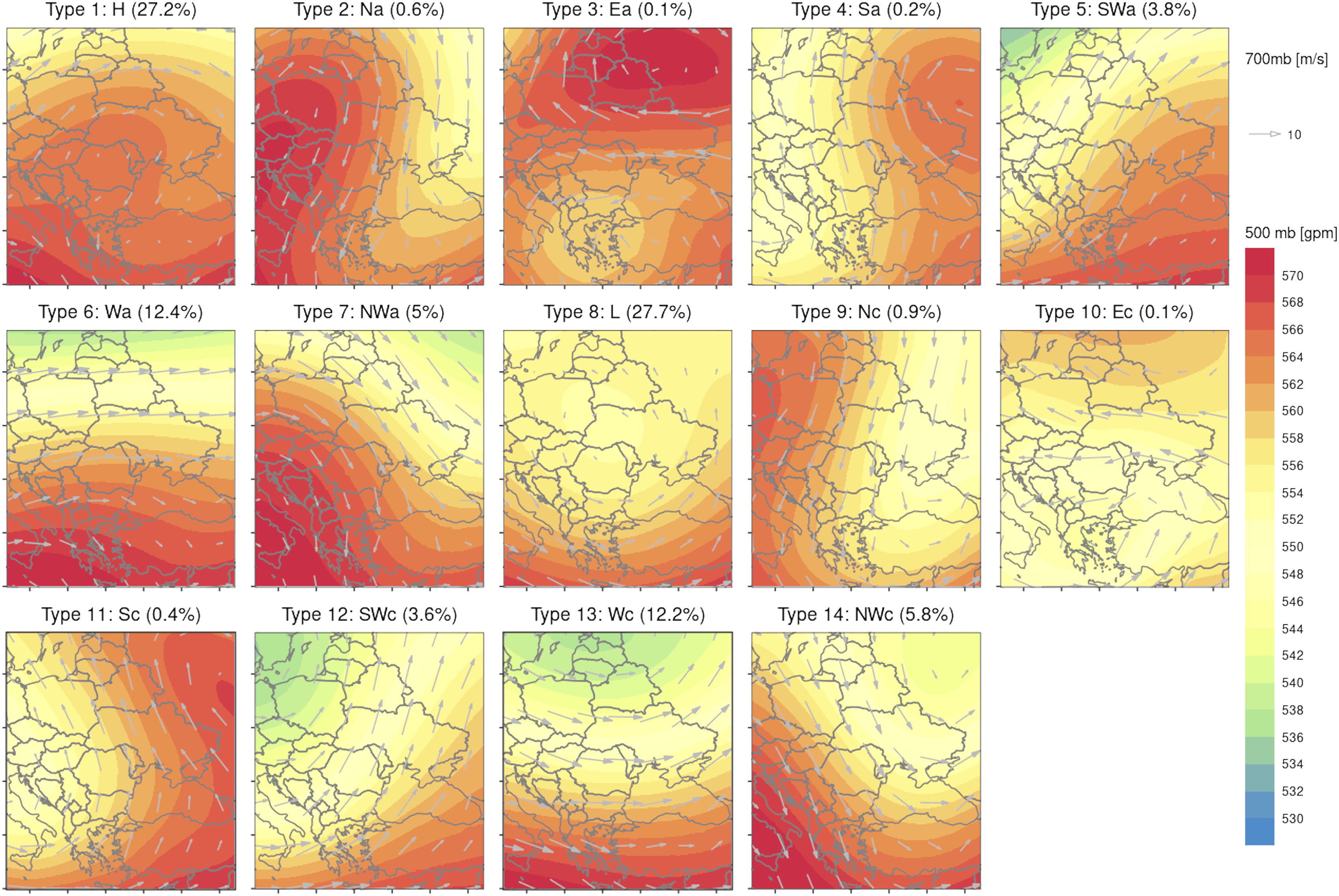
In order to give a more detailed image on the atmospheric circulation conditions associated with hailfalls at ground level, we used the Gross Wetter Typen (GWT) atmospheric circulation method (Beck et al., 2007). For this case, based on sea level pressure, 18 types of atmospheric circulation were obtained (Figure 5), grouped in cyclonic (types 1–8 and 17) and anticyclonic (types 9–16 and 18) conditions prevailing over the selected domain. This way, each of the 357 hail days was assigned to both above presented classifications. GWT atmospheric circulation types derived using COST733 software and their relative frequency for April-October (1981–2020).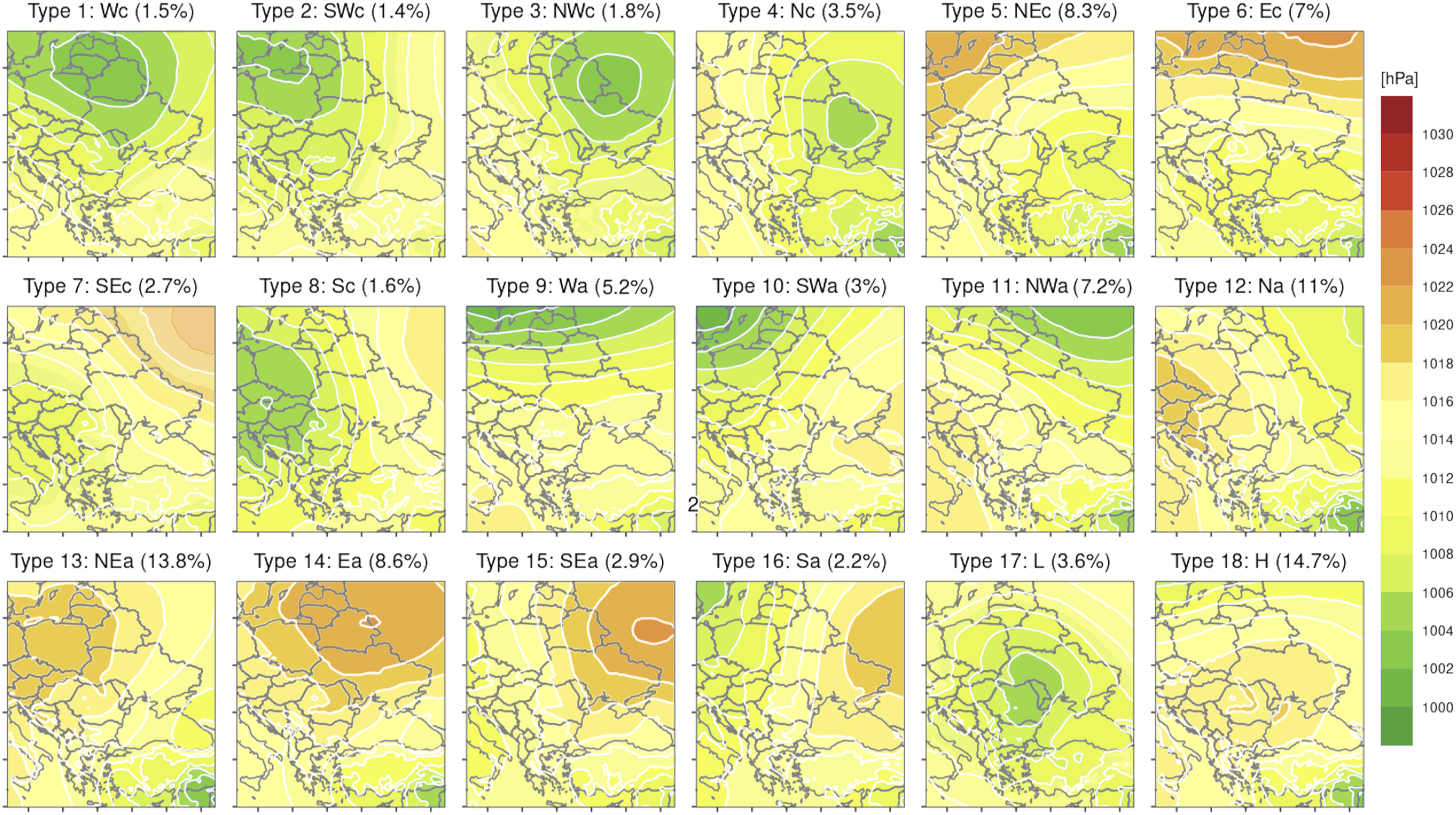
Due to the importance of the domain size selection for the final obtained results (Beck et al., 2016; Barbu et al., 2016), we ran the classifications over a subcontinental domain having in its center the studied region (Figure 4 and Figure 5) increasing the relevance of the results for mesoscale level. Also, these classifications were run only for the convective period during which the hail occurs, namely from April to October and for the 12:00 PM local time of the day, trying to capture the convective developments in the afternoon, the classical daytime period for hail occurrence (as indicated in Figure 2(b)).
Normally, a higher frequency of an atmospheric circulation type automatically induces a higher frequency of hail days during that specific circulation type. Therefore, the relative frequency of hail days for each circulation type was extracted from the relative frequency of that circulation type between April and October. The resulted differences obtained can have positive/negative values, defining the over-representation/under-representation of that atmospheric circulation type in hail occurrence (Figures 6 and 7). The over-representation/under-representation of one circulation type in hail occurrence means that hail is more/less common for the days characterized by that specific circulation type. In terms of predictability, the over-representation/under-representation is directly associated with high/low probability for hail occurrence in those synoptic conditions. Relative frequency of the number of hail days for the 14 WLK atmospheric circulation types (green bars) and their corresponding over-representation (red bars)/under-representation (blue bars) in the relative frequency of hail occurrence during each atmospheric circulation type in north-eastern Romania (1981–2020). Relative frequency of the number of hail days for the 18 GWT atmospheric circulation types (green bars) and their corresponding over-representation (red bars)/under-representation (blue bars) in the relative frequency of hail occurrence during each atmospheric circulation type in north-eastern Romania.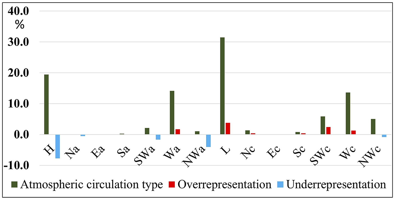
2.4. Atmospheric instability assessment
The atmospheric environment associated with the different synoptic patterns determining hailfall is described in our study using some defining atmospheric parameters for hail occurrence, such as most unstable convective available potential energy (MUCAPE), convective inhibition (CIN), maximum wind shear (WMAXSHEAR05), freezing level (FL) and low level humidity (LLH). All these parameters were extracted from ERA-5 database (C3S, 2017).
CAPE is one of the most valuable predictors of severe storm and hail occurrence worldwide (Doswell and Schultz, 2006; Prein and Holland, 2018). For Europe, the mean CAPE values characterizing the convective environment of middle size hail (2–5 cm) occurrence is around 500 J/kg (Holley et al., 2014; Istrate et al., 2021; Púčik et al., 2015; Taszarek et al., 2017). According to recent studies of large hail occurrence, such conditions are most often found in a significant/moderate CAPE, combined with moderate/high shear environments (Berthet et al., 2013; Craven and Brooks, 2004; Edwards and Thompson, 1998; Groenemeijer and Van Delden, 2007; Kaltenböck et al., 2009; Púčik et al., 2015; Taszarek et al., 2017). MUCAPE is derived from CAPE and represents a vertically integrated index and measures the cumulative buoyant energy in the free convective layer from the level of free convection to the equilibrium level (Doswell et al., 1994). However, MUCAPE alone cannot explain the atmospheric instability, especially due to the fact that thermal stratification can lead to the occurrence of stable layers in the lower troposphere. In order to have information on these stable layers, we added also the convective inhibition (CIN) (Riemann-Campe et al., 2009) in our analysis.
We also used a composite product of instability and vertical wind shear, specifically, a square root of two times CAPE multiplied by 0–6 km wind shear (WMAXSHEAR), as indicated by Brooks (2013), Groenemeijer and Van Delden (2007) and Taszarek et al. (2017). Brooks (2013) and Púčik et al. (2015) found that of all severe weather threats, large hail depends most strongly on high CAPE combined with strong shear between 0 and 6 km above ground level. For Europe and the United States, the probability for large hail increases along with increasing WMAXSHEAR (Taszarek et al., 2017, 2019; 2020b). Also, since it was observed that the probability for extreme hail occurrence is maximized when the mixing ratio is around 15 g*kg−1 (Taszarek et al., 2017), we used the low level humidity in our study (Doswell, 1987; Giaiotti and Stel, 2006). This parameter was obtained from ERA-5 database by averaging the mixing ratio values from 1000 hPa, 975 hPa and 950 hPa geopotential heights.
The fifth parameter, freezing level height (FL) was taken into consideration especially due to its important role for the hail distribution observed on the ground (Fraile et al., 2003). Also, during the current climate change conditions an increase of this parameter values leads to enhanced melting of hailstones and a shift in the distribution of hailstone sizes towards larger hailstones (Dessens et al., 2015; Raupach et al., 2021).
3. Results and discussion
3.1. Middle level flow associated to hailfall in north-eastern Romania
The assignment of the 357 of hail days among the WLK circulation types (Figure 6) indicates clearly some types of atmospheric circulation which are prone to triggering the development of convective cells that can generate hailfall on the ground in north-eastern Romania.
Based on these results, the following synoptic patterns emerge as being specific for hail occurrence in north-eastern Romania: 1. Cut-off lows (L) structures are represented by WLK circulation type 8 (L) (Figure 6). These conditions sum up 33.1% of hail days and 28% of the total number of days, indicating its over-representation in hail occurrence. By far, this represent the most frequent atmospheric circulation type in the middle troposphere associated to hailfalls in the studied region. 2. Weak Easterly or North-Easterly anticyclonic flow is represented by circulation type 1 (H). This indicates prevailing anticyclonic conditions over the region, with a weak north-easterly flow, but strong enough to drive the cell storms towards the eastern flank of the Carpathians. This atmospheric pattern shares 27.2% of the total number of days between April and October, but gathers only 19.5% of hail days. Also said, the hailfalls are rather uncommon for this circulation type and their higher relative frequency in hail occurrence is induced by the fact that these atmospheric circulations are very frequent throughout the year. 3. Strong Westerly flow (WF) is represented by two WLK circulation types that are very similar, the difference being given by the degree of zonality of the middle level flow. For Type 6 (Wa), the westerly zonal flux is very strong and embedded in anticyclonic conditions, with features that are very similar to south-westerly wind vector represented by Type 5 (SWa). For Type13 (Wc) instead, the westerly flow takes the shape of a trough like structure developed over the continent, approaching to north-westerly wind vector represented by Type 14 (NWc). These two circulation types gather together 13.5% of the total number of days between April and October, but they summon 29.1% of the number of hail days. Thus, the hail fall is highly over-represented during these weather patterns, meaning that these conditions are very common for hail occurrence. 4. Very strong South-Westerly flow (SWF) is represented by Type 5 (SWa) and Type 12 (SWc). The frequency of these circulation types in hail occurrence is 8%, with cyclonic type over-represented and the anticyclonic type under-represented in hail occurrence (Figure 6). 5. Strong North-Westerly flow (NWF) is represented by Type 7 (NWa) and Type 14 (NWc). These atmospheric circulation types have a relative frequency of 10.9%, but they concentrate only 6.2% of hail events, from which results a small under-representation of hail in such atmospheric conditions.
In brief, it should be underlined that these 5 major synoptic patterns sum up almost 98% of hail days in north-eastern Romania. Also, from this analysis we can observe that weather patterns characterized by wind vector in middle troposphere from easterly, southerly, and even northerly (Types 2–4 and Types 9–11) directions are rarely associated with hail occurrence.
Not least, this high concentration of hail days during a relatively small number of synoptic patterns characterizing the middle troposphere increase the predictability of hail in relation with large scale atmospheric circulation.
3.2. Atmospheric circulation at sea level pressure associated to hailfall in North-Eastern Romania
Analyzing the weather patterns at ground level, as they are indicated by GWT atmospheric circulation classification (Figure 7), the hail days can be grouped in the following major patterns: 1. North-easterly and easterly atmospheric circulations in cyclonic (Type 5 - NEc, Type 6 - Ec) or anticyclonic (Type 13 - NEa, Type 14 - Ea) conditions. This major type corresponds with persistent anticyclonic blocking over central and eastern Europe that isolate a large low pressure area over south-eastern Europe. These conditions sum up 37.8% of the hail days over the studied region. Not surprisingly, this pattern largely corresponds with the most common synoptic conditions determining hail occurrence in Romania identified by Burcea et al. (2016). Beside their high frequency, the cyclonic conditions are over-represented (NEc, Ec), while the anticyclonic conditions (NEa, Ea) are under-represented in hail occurrence (Figure 7). 2. North-westerly and northerly atmospheric circulation in cyclonic (Type 3 - NWc, Type - Nc) or anticyclonic (Type 11 - NWa, Type 12 - Na) conditions. Generally, these conditions indicate a low pressure area passing from the Atlantic towards the inner part of the continent, the hail being mostly associated with the cold front passages over the region or with squall lines developing just before the cold front arrival, as observed for Poland (Taszarek and Suwala, 2015). Even if the hail occurs more frequently during anticyclonic conditions (Figure 7), one can see that these events are more common for cyclonic conditions, as indicated by their over-representation (especially for NWc). All these synoptic patterns sum up 23.4% of hail days in the studied region. 3. Westerly atmospheric circulations, both in cyclonic (Type 1 - Wc) and anticyclonic (Type 9 - Wa) conditions gather 7.8% of hail days with a certain over-representation in relation to the frequency of these types of atmospheric circulation over the region. 4. Pure cyclonic conditions (L) indicate the presence of a low pressure area over the region and gather 10.6% of hail days. Most probably, this type of circulation can represent the final phase of a cyclone development over south-eastern Europe, having either Icelandic or Mediterranean origins, meaning that it can be associated with all the patterns indicating north-easterly circulation mentioned above.
These 4 major atmospheric circulation patterns sum up 71.4% of the total number of days with hail over the region. Beside these major types, there are also cases of hailfall during south-westerly flow (Type 2 - SWc and Type 10 - SWa), but their relative frequency is small, being however over-represented. The southerly circulations at the ground level instead (Type 16 - Sa, Type 8 - Sc) are the most uncommon weather patterns for the hail occurrence in north-eastern Romania. Somehow surprisingly, GWT classification indicate that hail occurs even during anticyclonic conditions on the ground level (H), this being explained by the frequent association of these conditions with westerly wind vector in altitude, which is able to determine orographic convection over the Carpathian Mountains. The clouds resulted from these convective developments are directed after that towards the north-eastern region of Romania by the middle troposphere flow. This aspect could be explained by the fact that GWT classifies as anticyclonic all the days with sea level pressure higher than 1013 hPa over the domain center, even when the peak pressure value is not very high and the corresponding anticyclonic conditions are not very well expressed. Thus, very often, the degree of atmospheric stability for these anticyclonic conditions is not very high, so that through thermal instability storm cells can easily develop. However, these anticyclonic conditions are largely under-represented in hail occurrence (Figure 7).
3.3. Major synoptic patterns associated with hailfall days
Despite the high concentration of hail days in a relatively small number of atmospheric circulation patterns on a single level (middle troposphere or ground level), as observed and analyzed above, the combined atmospheric conditions between middle troposphere and ground level for each hail event are far more complicated.
To better understand this aspect, we conceived a contingency table where each hail event was assigned to both, middle and ground levels conditions (Figure 8). So, we can observe that the total of 357 hail days are distributed in 252 possible combinations (14WLK*18GWT) of circulation types (CCTs). From all these possible CCTs, the hail occurred at least 1 day in up to 79 CCTs. However, only 35 CCTs gather more than 3 days with hail (Figure 8). The contingent number of hail days between WLK and GWT in north-eastern Romania; colored cells indicate the 16 CCTs explaining approx. 85% of the hail days from 1981–2020.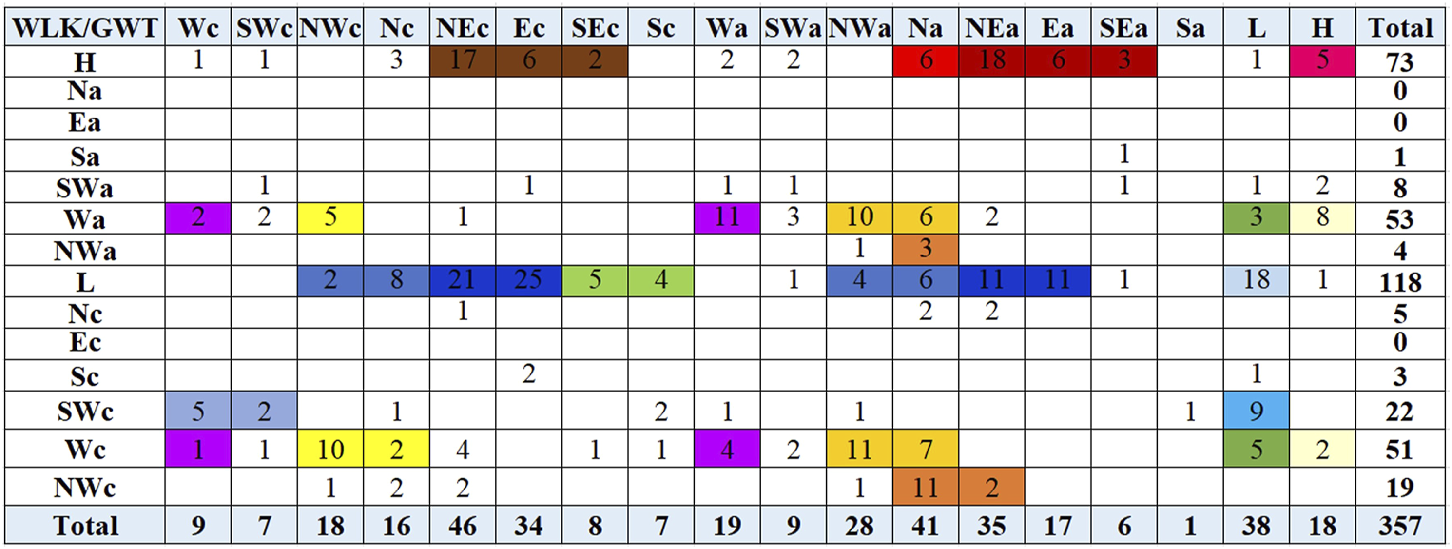
From this high diversity of CCTs, only 16 were identified as being more relevant for hail occurrence due to their higher relative frequency (Table 1). Actually, these 16 CCTs are summing up 297 days, representing 83.1% of the total number of hail days in the studied region. At their turn, these 16 CCTs can be grouped in 5 major weather patterns (MPs), outlined on the basis of the atmospheric circulation in the middle troposphere. 1. Cut-off lows developed in middle troposphere represent the most important MP for hail occurrence over the studied region and, taking into account the ground level conditions, 3 CCTs with different advection directions emerge: north-westerly/northerly (L-NW/N-c/a), north-easterly/easterly (L-NE/E-c/a) and south-easterly (L-SE-c/a) (Table 1, Figure 9). Additionally, the 4th CCT represents the peculiar case when the region is dominated by low pressure centers both at the ground level and in the middle troposphere (L-L). This MP is commonly associated with hail occurrence in the studied region, gathering 24.4% of all hail days (also said 1 in 4 days with hail occur in this MP). Major synoptic patterns (MPs) determining hail occurrence in north-eastern Romania. Composite maps describing mean conditions for SLP, 500 hPa geopotential height, wind vector and speed at 700 hPa and precipitation amount at continental scale for the hail days occurred in cut-off low conditions (L) over the north-eastern Romania.
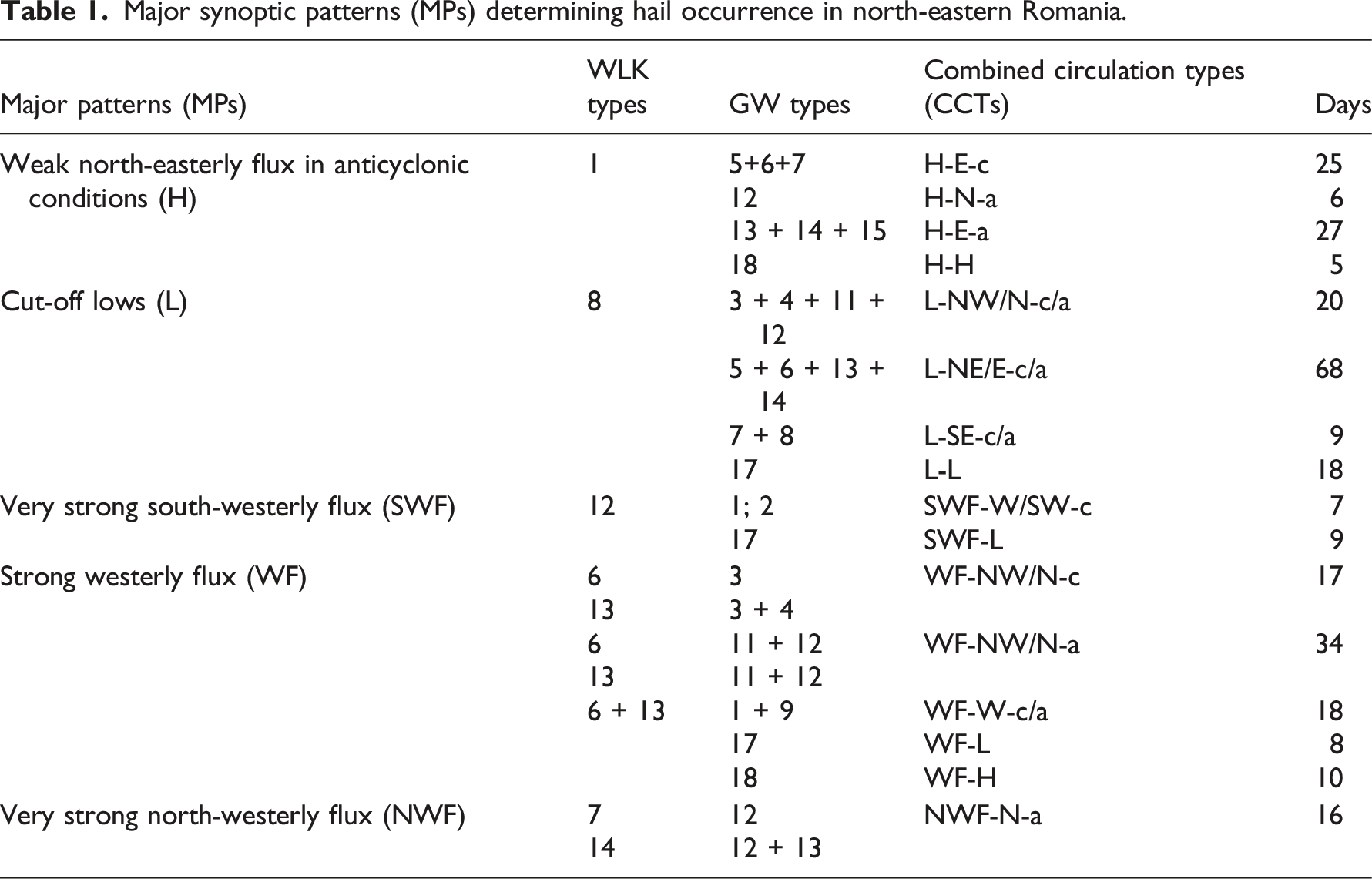
Actually, the cut-off lows acting over the region of Romania (Dobri et al., 2017) are known to be connected with anticyclonic blocking in different regions of central or northern Europe (Mohr et al., 2019), so that our results highlight the importance of these large-scale mechanisms for the hail occurrence in north-eastern Romania.
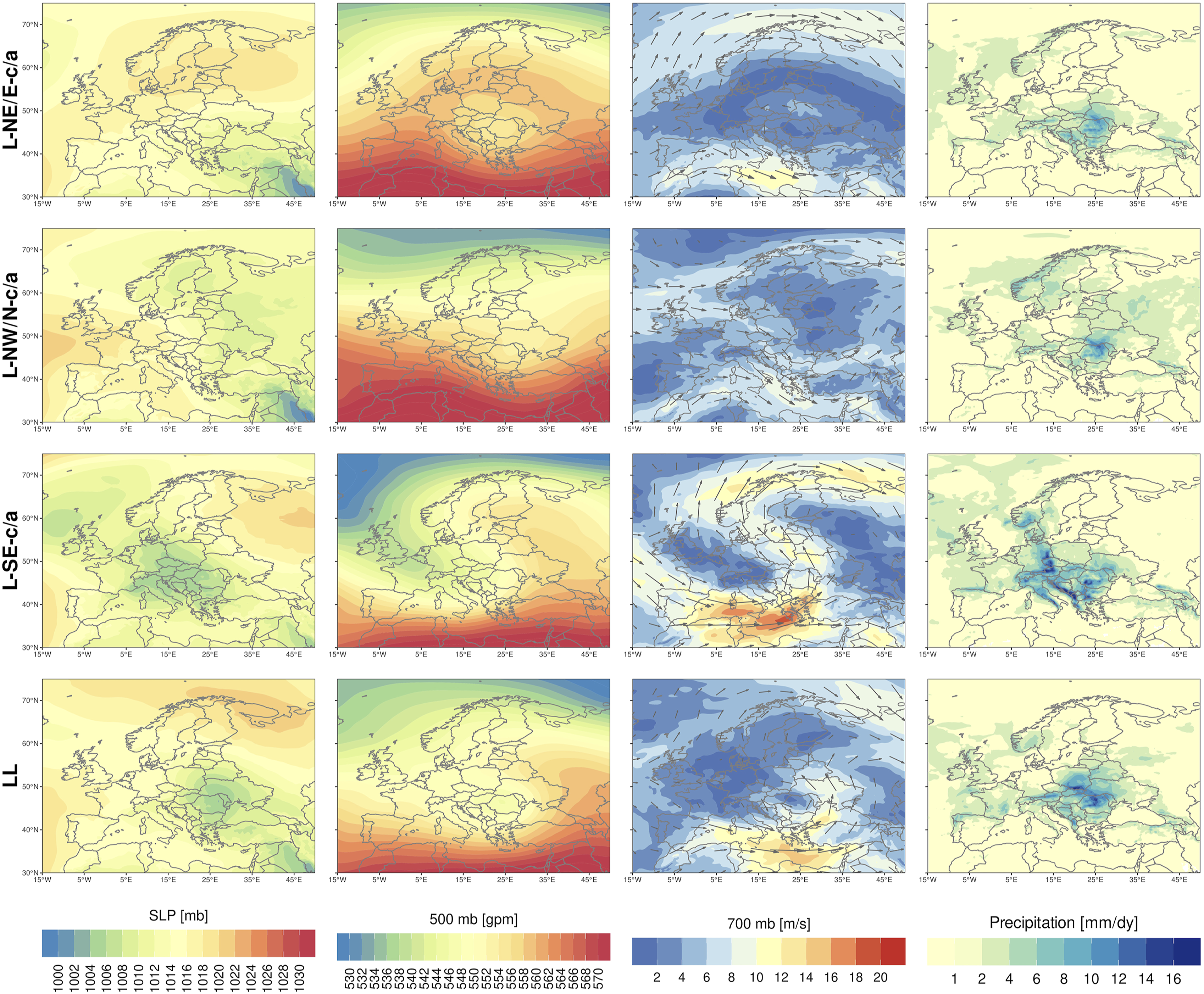
On the composite maps of these 4 CCTs (Figure 9) at continental scale, the cut-off low structures are clearly indicated only for L-NE/E-c/a and L-L for 500 hPa geopotential height. For L-SE-c/a and L-NW/N-c/a instead, the cut-off low structure are weak, long-wave troughs being present in region of Romania. This indicates that this cut-off lows are perceivable only at mesoscale over the region. Also, in the region of Romania low pressures are common in these conditions at ground level, but in connection with high pressure field extended over the north (L-NE/E-c/a, L-L) or over the north-eastern (L-SE-c/a) parts of the continent. For all these CCTs, the Azores High is well developed in its subtropical cradle or even extended to the north (L-NW/N-c/a). The wind at 700 hPa is generally weak, except L-SE-c/a which is characterized by strong winds along the periphery of the long-wave trough extended over the western part of the continent. Generally, the precipitation amount is high for Romania’s territory in all these conditions (Figure 9). 2. Weak easterly or north-easterly flow in middle troposphere in anticyclonic conditions (H) can be classified in 4 CCTs: H-N-a, H-E-c, H-E-a, H-h. Interestingly, this MP includes a cyclonic type of atmospheric circulation at ground level (H-E-c) that manifested even if in the middle troposphere positive anomalies of atmospheric pressures prevail. The most interesting CCT indicates anticyclonic conditions through the entire troposphere (H-H), a situation that can represent an artefact of the atmospheric classifications used. Actually, in some cases anticyclonic types are indicated by WLK as a result of the pressure distribution presenting a small peak above 1015 hPa over the analyzed region, even if the sea level pressure is not sufficiently high to inhibit convective developments. All these CCTs sum up 63 days and share 16.7% of the total number of hail days.
For central Europe, the so-called high pressure convection has been found to be the most important synoptic pattern inducing hail occurrence (Kunz et al., 2009) and is known to play a very important role in hail occurrence on the north-eastern Adriatic (Jelic et al., 2020). Also, Kolkowska and Lorenc (2012) found that for Poland a third of hail events is linked to easterly flow, similar to our results.
The composite maps of each CCT at continental scale (Figure 10) indicate the development of ridges over Romania’s territory at 500 hPa. At ground level, Azores ridges are well developed, being extended on the northern half of the continent (H-E-a, H-E-c), leading to easterly atmospheric circulation over north-eastern Romania. For H-H subtype, as well the Azores high, is extended over the entire southern half of the continent, while for H-N-a subtype the Azores high is present over the western half of the continent. Specific for this MP is that the wind flow at 700 hPa is very weak over the study region and the amount of precipitation is generally weak with a peak over the Carpathian Mountains. Composite maps describing mean conditions for SLP, 500 hPa geopotential height, wind vector and speed at 700 hPa and precipitation amount at continental scale for the hail days occurred in north-easterly anticyclonic conditions (H) in north-eastern Romania.
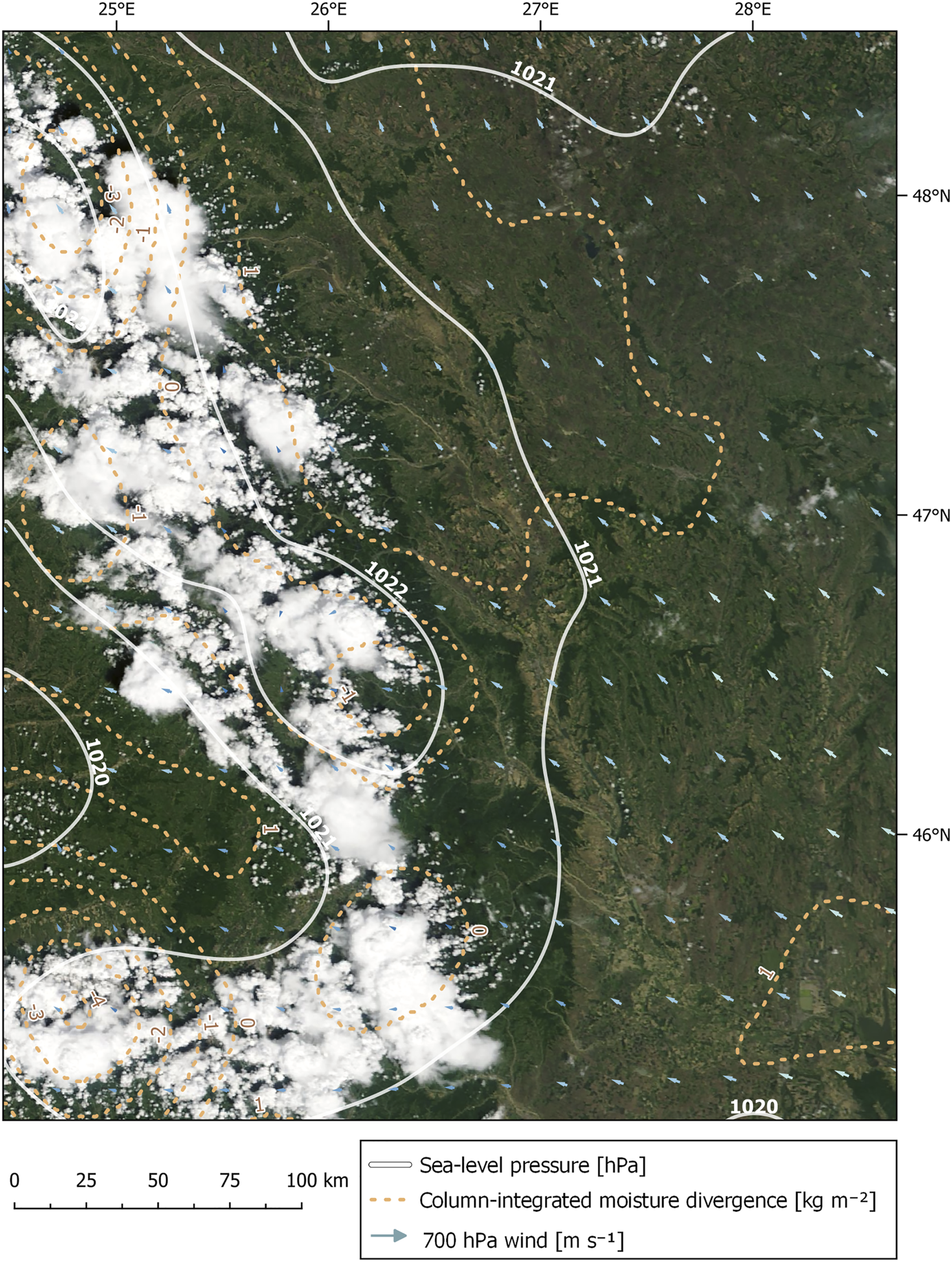
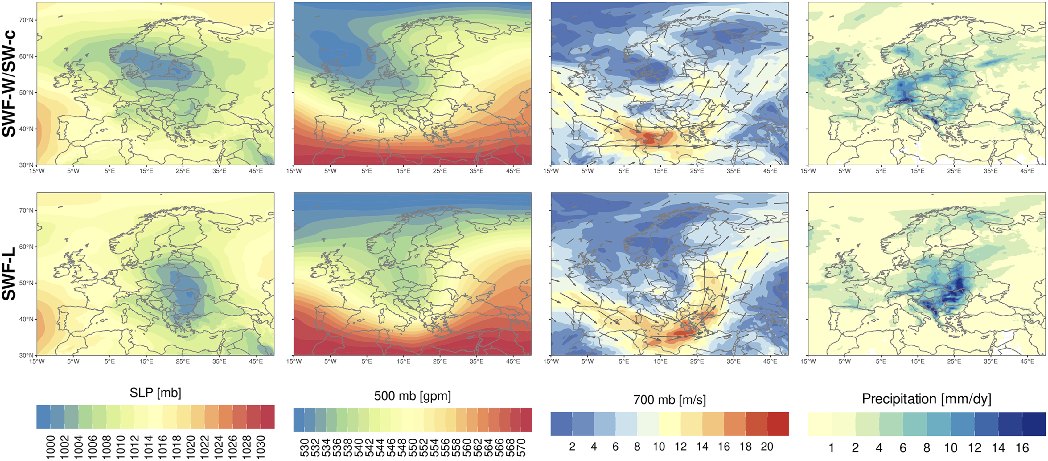
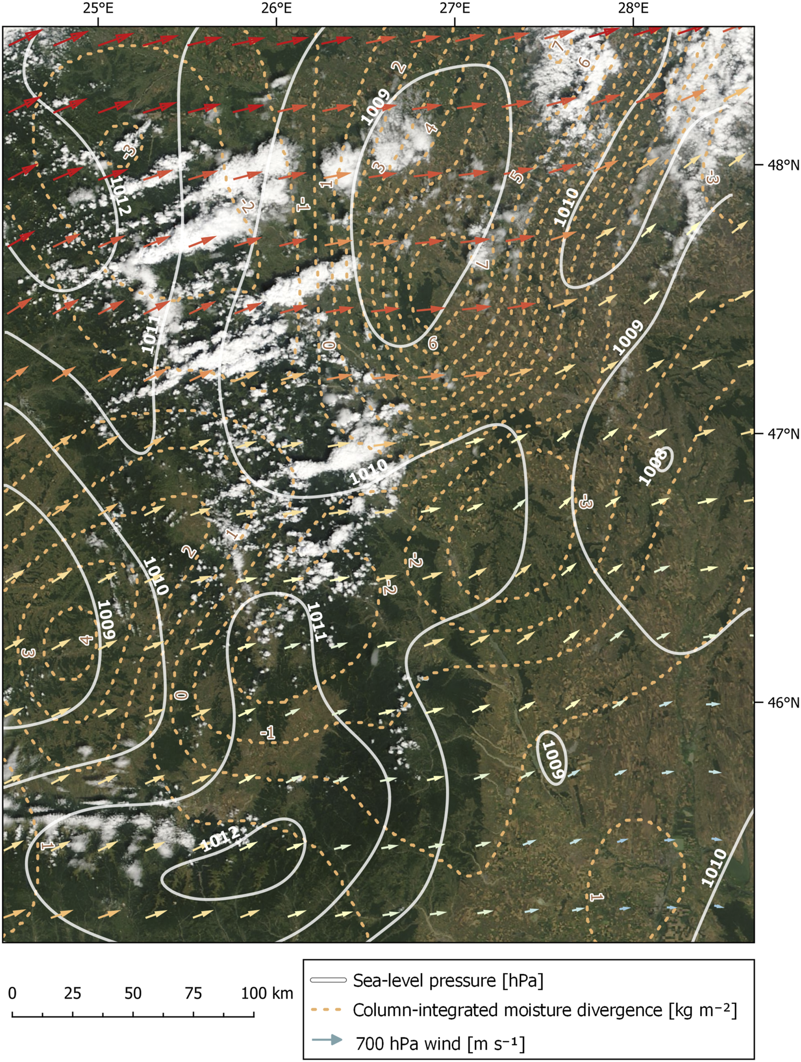
Actually, Carpathian Mountain play a triggering role in convective developments that can affect also the north-eastern Romania. As we can see for 24 of May 2011 (Figure 11), a day recording hailfall in north-eastern Romania in H-H conditions, despite high pressure conditions indicated by values >1020 hPa and weak convergence conditions over the region, a weak wind vector at 700 hPa is capable of driving the air mass towards the line of eastern Carpathians from the east. This determines forced lifting on the easterly flank of the Carpathians and leads after that to cell storm development that propagates over north-eastern Romania. 3. South-westerly flow in altitude (SWF) comprises 2 CCTs, either from the combination with a westerly or south-westerly atmospheric circulation at ground level in cyclonic conditions (SWF-W/SW-c), or from the association with a low pressure center over the region (SWF-L). Only 4.5% of hail days are concentrated in this MP. Convective clouds developed during HH CCT under weak south-easterly advection as effect of orographic lifting over Carpathian Mountains (24.05.2011/MODIS Terra image).
For these cases, long-wave troughs of Icelandic origins are well developed over the western part of the continent (Figure 12), reaching the Mediterranean domain and deep cyclones are indicated at the ground level both for SWF-W/SW-c and SWF-L. The wind vector is very strong in both subtypes, with the study region in the upward side of the troughs, along the south-westerly wind vector. Also, the precipitation amount over the study region is considerable, especially for SWF-L. 4. The strong westerly flux (WF) can be split into 5 CCTs, as described in Table 1: northerly or north-westerly advection on the ground level, either in cyclonic (WF-NW/N-c) or anticyclonic (WF-NW/N-a) conditions, westerly advections on the ground (WF-W-a/c) and prevalence of low pressure (WF-L) or high-pressure (WF-H) centers over the region. Composite maps describing mean conditions for SLP, 500 hPa geopotential height, wind vector and speed at 700 hPa and precipitation amount at continental scale for the hail days occurred for south-westerly flow conditions (SWF) in north-eastern Romania.
All these CCTs sum up 63 days representing 24.3% of the total number of hail days. The prevalence of westerly flow as background for hail occurrence was observed previously for the studied region using Hess-Brezowsky method (Ilie et al., 2020) and represents a common synoptic background leading to hail occurrence in other regions of the continent (Blair et al., 2017).
When high pressure prevails on the ground level (WF-H) the convective inhibition is high, as a result of the low amount of humidity at ground level and the warming at 700 hPa (Myoung and Nielson-Gammon, 2010) so that the convective development will be inhibited. In this case, only a strong convective initiation enabled by high values of MUCAPE over the mountain range can disrupt the stable layer, leading to strong development of deep moist convection. When the disruption of the stable layer succeeds, supercell storms occur, being associated with a disproportionate fraction of severe weather hazards, including extreme hailfalls (Rasmussen and Blanchard, 1998). This represents the most favorable environment for the largest hail size due to long sustained updraft movements (Blair et al., 2017). Our results are in line with the results obtained for Germany by Wapler and James (2015) indicating that those types of atmospheric circulations associated to western circulation tend to have a high moving horizontal speed which induces a higher probability to cause hailfall.
The composite maps of all WF CCTs (Figure 13) show a strong zonal flow at continental scale with high wind speeds at 700 hPa also over the study region. The wind vector shifts from WNW for WF-NW/N-a and WF-NW/N-c to WSW for WF-W-a/c, WFH and WFL. At ground level, the study region is placed between the high pressure field placed over the southern part of the continent and lows with Icelandic origins acting over the Scandinavian region or over the north-eastern parts of the continent. For WF-L, the pressure low is centered right over Romania. The precipitation amount is moderate over the study region and always higher over its northern parts. Composite maps describing mean conditions for SLP, 500 hPa geopotential height, wind vector and speed at 700 hPa and precipitation amount at continental scale for the hail days occurred for westerly flow conditions (WF) in north-eastern Romania.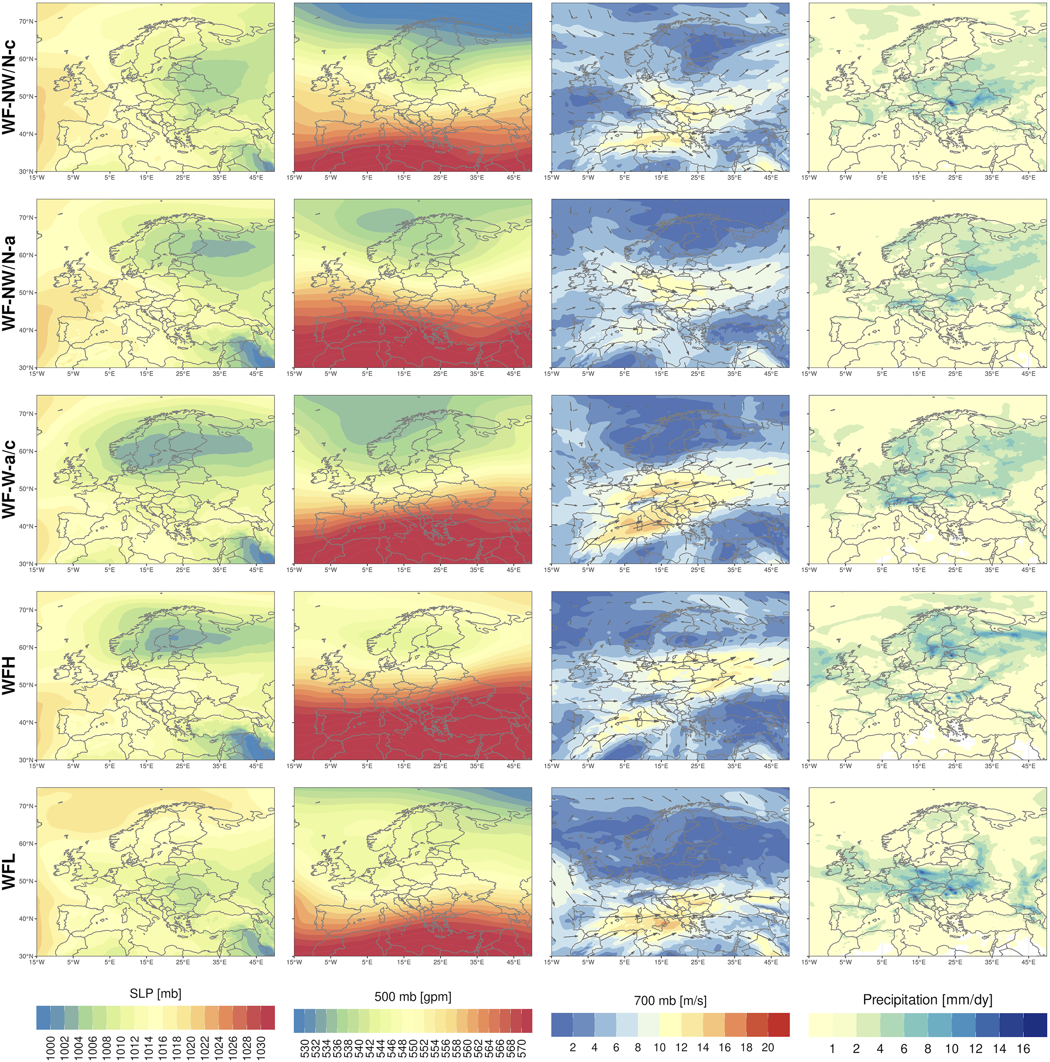
For westerly flow conditions, the Carpathians seem to play a major role in enhancing high values of MUCAPE, which is capable of initiating convection firstly on the mountain range. The convective cells developing during such conditions (low sea pressure and high convergence) on the mountain range are moving after that towards the east, being driven by the strong westerly flow, as observed for 15 of July 2012 in WF-H conditions (Figure 14). In this way, the cell storms can generate hailfall especially on the western side of the study region. This distribution pattern explains the higher frequency of hail occurrence in the proximity of Eastern Carpathians observed by other authors at continental (Punge et al., 2017) and national (Burcea et al., 2016) scale for the north-western part of the studied region. Moreover, the penetration of cold air in altitude during intense westerly circulation—while the lower warmer and moist layers of the troposphere are sheltered by the mountain range—is able to induce high potential instability over north-eastern Romania, similarly to other regions situated in the proximity of the mountains (van Delden, 2001). 5. North-westerly flow (NWF) in altitude is combined with northerly atmospheric circulation in anticyclonic conditions (NW-N-a) at ground level as a single CCT. This MP shares 10.1% of the hail days in the region. Obviously, this MP can be subsumed to the westerly types, the difference being given by a shift from zonal to meridional atmospheric flow in altitude, corresponding to the downward side of jet-stream along the long-wave trough propagating towards the east of the continent. Convective clouds tilted in altitude towards ENE—corresponding with the WSW wind vector in altitude—developed as effect of orographic initiation over Carpathian Mountains during WF-H CCT (15.07.2012/MODIS Terra image).
The composite maps of this pattern indicate a strong Azores ridge developing a high pressure center over the southern part of the North Sea, while the eastern side of the continent is dominated by a low pressure area. The Azores ridge develops in connection with a strong and large ridge at 500 hPa in the same area, Romania being placed on its forward flank dominated by north-westerly flow at 700 hPa. The precipitation amount reaches its maximum along the Carpathian Mountains (Figure 15) due to orographic lifting. Composite maps describing mean conditions for SLP, 500 hPa geopotential height, wind vector and speed at 700 hPa and precipitation amount at continental scale for the hail days occurred for north-westerly flow conditions (SWF) in north-eastern Romania.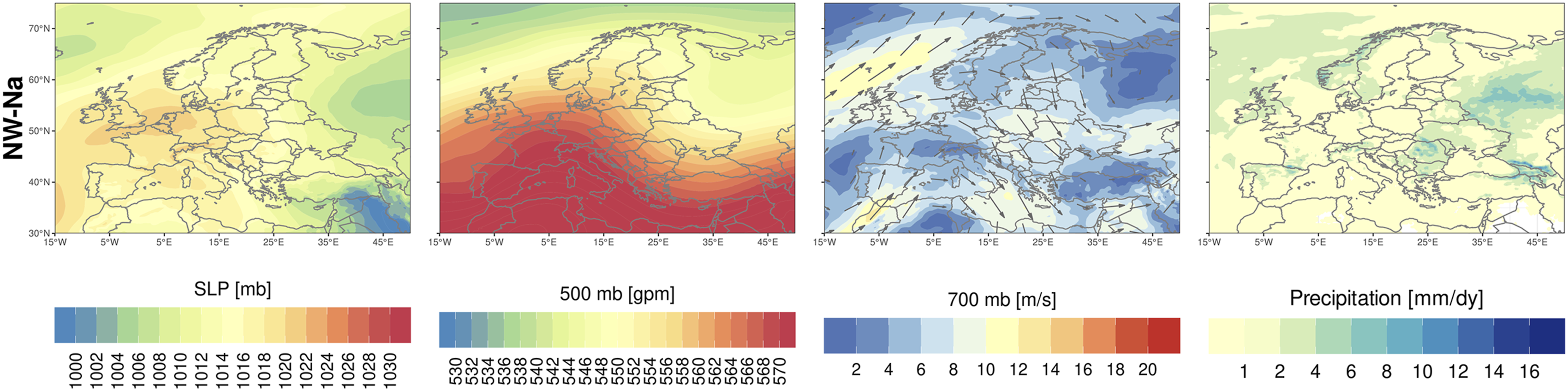
These conditions were indicated also as a main synoptic background for convective manifestations in central Europe (Piper et al., 2019). Moreover, we assess that these conditions are under-represented in hail occurrence for the north-eastern Romania as effect of the orographic sheltering of the region. During the manifestations of these atmospheric circulations, downward movements over the region are induced, especially close to the mountain range, and these are capable of inhibiting convective developments.
At a seasonal level, we can observe that May records the highest incidence of the hail days, followed closely by June and July (Figure 16(a)). Also, cut-off lows structures represent the main cause for hail occurrence seconded by westerly flow (Figure 16(b)). It is worth mentioning that instead of the May peak in hail occurrence, it is the June-July period that records the highest diameter of hailstones on the ground. The monthly number of hail days for the 16 CCTs (a) and the relative frequency of hail occurrence for the 5 MPs (b) associated with hail fall during the convective season (April-September) in north-eastern Romania; the number of hail days per month for each CCT (c) in north-eastern Romania (1981–2020).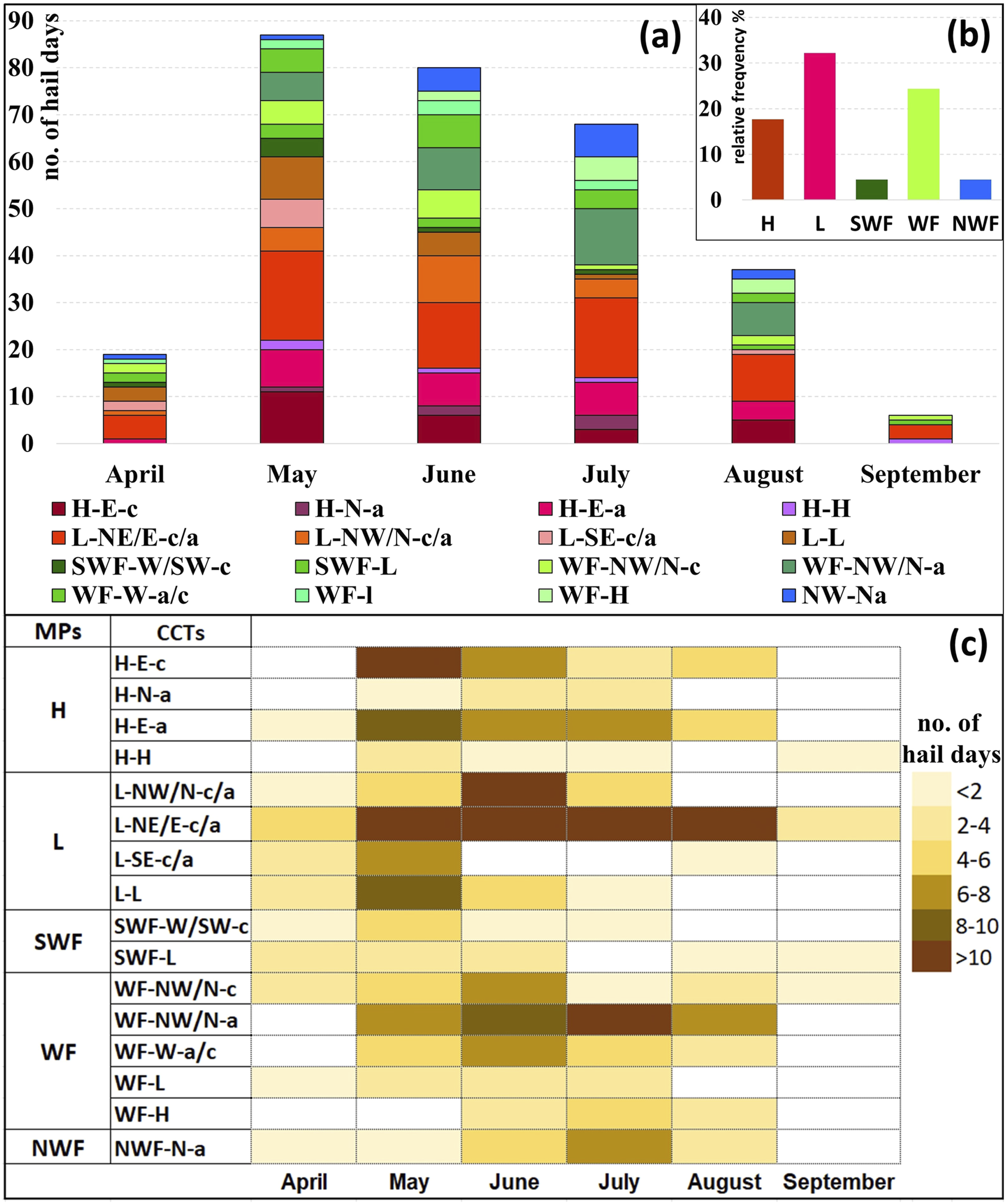
The beginning of the hail season in April starts mostly under cut-off lows conditions, associated especially with easterly advections at ground level (L-NE/E-c/a), but also by south-westerly and north-westerly MPs. The annual maximum from May is sustained mainly by cut-off lows (L) or anticyclonic (H) patterns. The anticyclonic patterns reach their maximum as background for hail occurrence in May, due to the fact that during this month the high amount of water vapor makes even a weak anticyclonic environment unstable. In June and July, the hail occurs during westerly flow (WF) gains importance, together with the cut-off low conditions. The WF reaches the maximum in July, especially in connection with north-westerly/northerly advections at the ground level (WF-NW/N-a). Overall, the westerly and south-westerly flows are mostly associated with extreme hail events during summer. For instance, the record of 9 cm in diameter of the hail stone from 18 of June 2016 (Istrate et al., 2019) is assigned in our classification to the south-westerly flux (SWF-H). Also, in July, the north-westerly flow in altitude (NWF) is one of the main synoptic pattern leading to hail (Figure 16(c)). Towards the end of the season, in September, the synoptic conditions inducing hail occurrence are quite similar with those from the beginning of the convective season (L, SWF).
According to previous results, the 5 MPs related to hail occurrence can be separated into weak advection patterns (H and L) and strong advective patterns (SWF, WF, NWF). Since these two major patterns associated to hailfall in north-eastern Romania represent different types of atmospheric circulation, we tried to investigate the trend in the occurrence of these atmospheric circulation conditions for the studied period (1981–2020) (Figure 17). Annual frequency of the main weather patterns associated to hail occurrence in north-eastern Romania (1981–2020).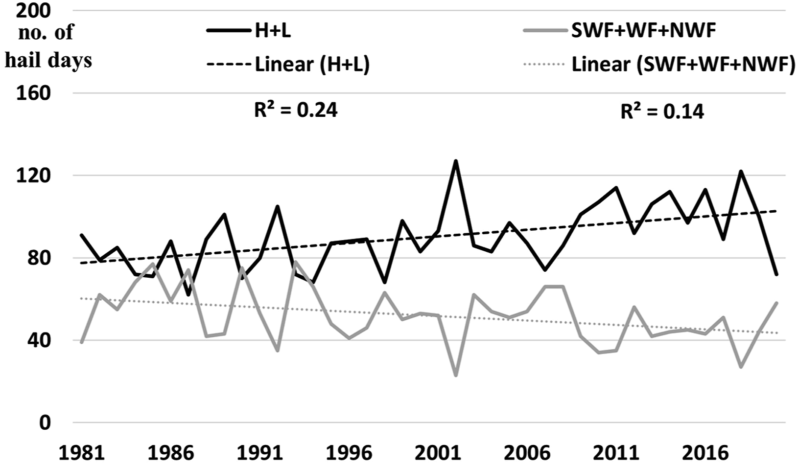
In this way, we can observe an opposite trend in the annual frequency of these weather patterns. While the weak advection patterns present an increasing trend (Sen’s slope = 0.71; significance at p-value < 0.05), the strong advection patterns follow a decreasing trend (Sen’s slope = −0.40; significance at p-value < 0.10). Thus, overall, during the analyzed period the atmospheric circulations offered the same chances for hail occurrence, even if strong advection patterns tend to fade in front of weak advection patterns in the last decades.
3.4. Convective environment associated to main hail prone synoptic patterns
It is well known that CAPE is one of the main ingredients indicating atmospheric instability, but our results show that in most cases even a quite limited CAPE can be sufficient for hail occurrence, as for north-westerly flow (Figure 18). Generally, the north-easterly anticyclonic pattern (H) is characterized by the highest mean MUCAPE, indicating that pronounced atmospheric instability is needed in order to generate storm cells in an inhibiting anticyclonic environment. In addition, the high level of instability over the mountain region in these conditions (Figure 18) supports the orographic convective initiation of these events. Moreover, the cell storms development in this case is favored by low levels of CIN and high level of humidity in the lower troposphere. In the case of cut-off lows CCTs (L) instead, the higher values of MUCAPE characterize the lowland regions. Anticyclonic conditions are also characterized by low wind shear and high freezing levels, while the cut-off low conditions are characterized by moderate wind shear and low freezing level (Figure 18). Spatial distribution of the atmospheric environmental parameters representative for instability (MUCAPE, CIN, wind shear, low level humidity and freezing level) for the 5 MPs.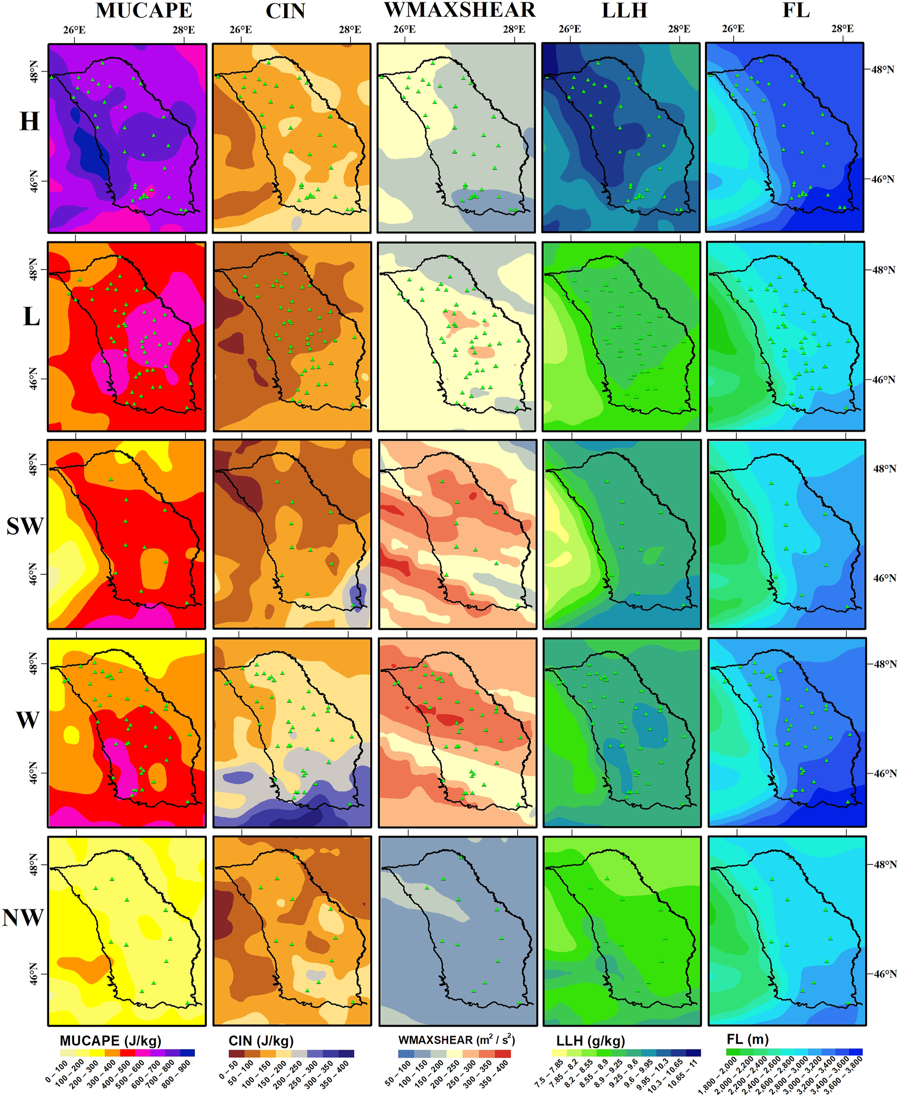
WF and SWF patterns are characterized by intermediate values of MUCAPE (500–1000 J/kg), but with higher/lower CIN for SWF/WF. The highest values of CIN associated with WF hail days indicate that in these conditions the cell storms develop explosively if the convective initiation succeeds to disrupt the stable layer related to higher CIN (WF-W-c/a and WF-NW/N-a indicate the highest value of CIN in Figure 19). These conditions generally correspond with storms developed in the warm air sector of Atlantic cyclones following easterly tracks, being known that the warm region of an active cyclone is characterized by high values of CAPE (Holley et al., 2014; Sulik, 2021). Instead, hail days occurring with a background given by NWF are characterized by the lowest values of CAPE (Figure 18, Figure 19). One important ingredient for large hail events occurring during WF and SWF MPs is represented by the highest values of wind shear (Figure 18 and Figure 19). Atmospheric environmental parameters (MUCAPE, CIN, wind shear, low level humidity and freezing level) corresponding to the main 16 CCTs.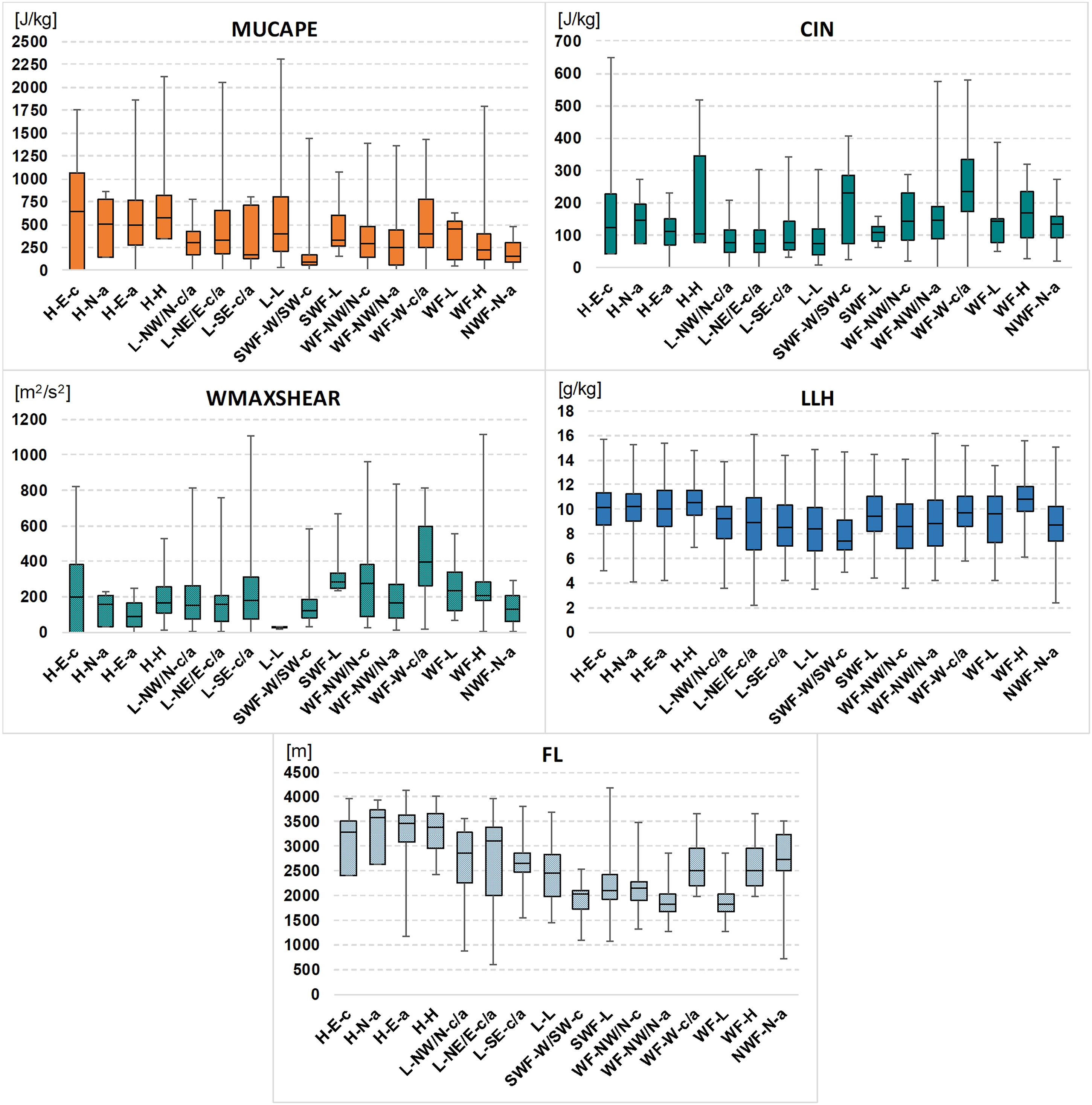
One major problem for interpreting these results is given by the temporal resolution of the images which corresponds with the 12 PM of each day, while the hail occurred generally during the afternoon, but at a different moment—for instance between 05 and 07 PM (Machidon and Apostol, 2011)—so that our maps cannot picture out exactly the conditions during the hail occurrence.
The maximum hailstone diameter is the lowest for the NWF, H and L MPs, while the largest hailstone occurred during SFW and WF MPs (Figure 20). However, the differences in this regard between major patterns are not very high, but these results indicate that extreme events occur mostly during SWF and WF patterns. Maximum diameter of hailstones for each MP types in north-eastern Romania (1981–2020).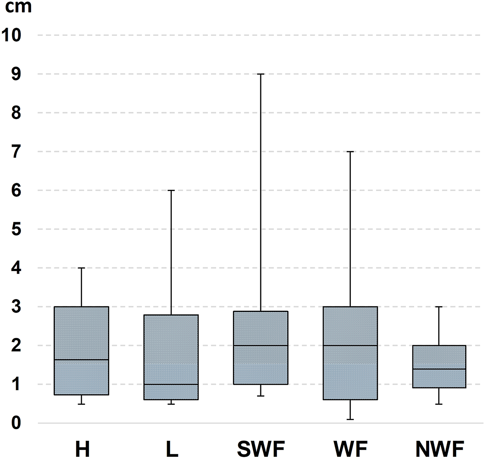
In order to better underline the mesoscale conditions of hail occurrence over the study region, we have analyzed as well the daily synoptic maps of Deutsche Wetterdienst archived on wetter3.de available period (2003–2017). This analysis indicates that 27 from the 47 days with hailfall (58%) during strong advective patterns (SWF, WF, NWF) were associated with cold front passages over the studied region. Instead, for the weak advection patterns (H, L) only 14 from the 70 days with hail (20%) were associated with cold front passages. Moreover, for weak advection patterns, 30 days (31%) indicate on these maps no frontal structures, the cell storms generating hail being developed in an unstable environment induced by high lapse rate and high amount of humidity.
4. Conclusions
Using two objective classifications of atmospheric circulation, applied for the middle troposphere (WLK) and ground level (GWT), respectively, 16 combined circulation patterns—grouped in 5 major circulation patterns—were identified over the north-eastern Romania as being associated with approximately 85% of hail days between 1981 and 2020. Moreover, the 5 MPs can be grouped in 2 main synoptic patterns taking into consideration the cell storms horizontal speed of movement: weak advection patterns and strong advection patterns. While the first one generates most of hail days during the convective season and prevails during May-June, the second one is associated with extreme events and prevails in July and August, but it gains in importance starting June, being associated in more than 60% to cold front passages. In fact, the most extreme hail events are related to cold fronts passages embedded in north-westerly circulation on the ground enhanced by very strong westerly or south-westerly flows in altitude.
The Carpathian Mountains play a complex and bidirectional role in hail occurrence over the region. On the one hand, the mountain chain is able to trigger the development of convective cells that generate hail in the extra-Carpathian region during very strong westerly flows. On the other hand, during easterly flow orographic convection can propagate the instability over the plateau region leading as well to hail occurrence.
Each circulation type is characterized by specific conditions of atmospheric environment with highest MUCAPE characterizing the north-easterly anticyclonic flow pattern, the highest wind shear for the south-westerly and westerly patterns, and the lowest CIN and freezing level for cut-off low pattern.
The results of this study are recommended to improve the efficacy of new intervention points in atmosphere, making part of the system on hail control implemented in Romania during the last decade.
Footnotes
Acknowledgments
This work was supported by the infrastructure of the Department of Geography of “Alexandru Ioan Cuza” University of Iasi, Romania, and it was provided through the CERNESIM Research Centre [Project nos. 257/28.09.2010, POSCCE-O 2.2.1, SMIS-CSNR 13984-901].
Declaration of conflicting interests
The author(s) declared no potential conflicts of interest with respect to the research, authorship, and/or publication of this article.
Funding
The author(s) disclosed receipt of the following financial support for the research, authorship, and/or publication of this article: This work was financially supported by the Department of Geography of “Alexandru Ioan Cuza” University of Iasi, Romania,