
Abstract
Coastal erosion and flooding are hazards that, when combined with facilitative pathways and vulnerable receptors, represent sources of coastal risk. Erosion and flooding risks are often analysed separately owing to complex relationships between driving processes, morphological response and risk receptors. We argue that these risks should be considered jointly and illustrate this through discussion of three ‘expressions’ of this interactive relationship: coastal morphology modifies flood hazard; future flood risk depends on changing shoreline position; and the simultaneous occurrence of erosion–flooding events. Some critical thoughts are offered on the general applicability of these expressions and the implications for coastal risk management policy.
I Introduction
Risks relating to water oversupply (e.g. extreme flood events) and undersupply (e.g. drought) first appeared in the World Economic Forum’s ‘Top 5 Global Risks’ in 2011 and have persisted ever since (World Economic Forum, 2018). These water risks arise from the interaction of socio-economic and environmental forcings. Coastal water risks are poised to be amongst the most severe global impacts, presently up to 75% of coastal regions vulnerable to ‘very large flooding events’ (Rueda et al., 2017). Furthermore, there have been assertions of a multiplicative relationship between sandy beach erosion and sea level rise (Zhang et al., 2004). These global assessments manifest locally during extreme events such as Superstorm Sandy (US east coast), Typhoon Haiyan (Philippines) and Cyclone Xaver (North West Europe) but also possess a more generic and permanent impression through reports of chronically eroding coastlines (Bird, 1985; EUROSION, 2004) and increasing flood losses (Hallegatte et al., 2013; Kron, 2013; Vitousek et al., 2017).
Coastal erosion and flooding are hazards which, when combined with facilitative pathways and vulnerable receptors, represent sources of coastal water risk. Coastal erosion can be defined as net removal of material from one coastal location to another. It is driven by many natural factors include changes in wave energy, sediment supply, global sea level change and regional / local land subsidence (Penland et al., 2005; Wong et al., 2014). Erosion results in a changing position of the shoreline, both in the vertical in relation to a particular datum (such as mean high water springs; Taylor et al., 2004) or, in the case of cliffed foreshores, in a migration of lateral position. Erosion is often accompanied by deposition, and changing shoreline position, elsewhere (e.g. Montreuil and Bullard, 2012), though material may be lost to suspension, solution and offshore below wave base. Coastal flooding is defined as temporary inundation of a terrestrial area that is not normally submerged. Trends contributing to a likely future increase in coastal erosion and flooding risk include: increasing population density (Hanson et al., 2011), asset concentration in coastal areas (Hinkel et al., 2014), accelerating sea level rise (Hay et al., 2015), potential changes to storm surge climate (Bader et al., 2011; Lewis et al., 2014) and declines in sediment supply (Syvitski et al., 2005). Considering these trends, the ability of decision makers to take appropriate (politically salient, publicly acceptable and financially sustainable) mitigation and adaptation management decisions relies critically on knowledge about the functioning of coastal systems and the risks that they present.
In spite of the availability of holistic management frameworks (e.g. Narayan et al., 2014; Sayers et al., 2002), erosion and flooding risks are often analysed and managed separately owing to the complex relationships between driving processes, morphological response and risk receptors (Dawson et al., 2009). We argue here that these risks should be considered jointly and illustrate this argument through the discussion of three ‘expressions’ of this interactive relationship: coastal morphology modifies flood hazard; future flood risk depends on changing shoreline position; and the simultaneous occurrence of erosion–flooding events. A final section takes a critical stance towards these expressions, the extent to which they are generally applicable, and the implications for future coastal risk management.
II The interactive relationship between erosion and flooding risk
The diversity of coastal systems is matched, in equal measure, by both the variety of interventions and the policies devised to manage them. Contemporary approaches to coastal hazard assessment and management are unified by the overarching concept of risk. The risk-based approach recognises that it is not cost effective, desirable, or feasible to protect all areas to the same standard, necessitating risk-based methodologies to determine which areas require protection and what standard of protection should be afforded. One such risk-based methodology is the source-pathway-response-consequence (SPRC) framework (Holdgate, 1979). This highlights the need for explicit attention to each part of the risk chain. By breaking down coastal risk into ‘sources’ (waves, surge, rain), ‘pathways’ (nearshore bathymetry, shoreline morphology), ‘receptors’ (residential and commercial property, critical infrastructure, people) and ‘consequences’ (flooding, erosion, increased insurance premiums, loss of life), the framework can be used to pinpoint areas contributing to overall risk. The SPRC framework is contextualised within a broader ‘flood system’ which includes global environmental drivers such as climate change and policy responses (Evans et al., 2006; Narayan et al., 2012; Sayers et al., 2002; Thorne et al., 2007).
Accepting the flood system as context for the discussion of coastal risk, this paper argues that coastal erosion and flooding should be analysed jointly, because although each represents a stand-alone hazard, they also interact (Figure 1) as follows. Erosional (and depositional) processes modify the nature of the coastal zone with implications for susceptibility to elevated water levels and resultant flooding; and The elevated water levels necessary to generate flooding hazard possess the ability to effect erosional (and depositional) change.
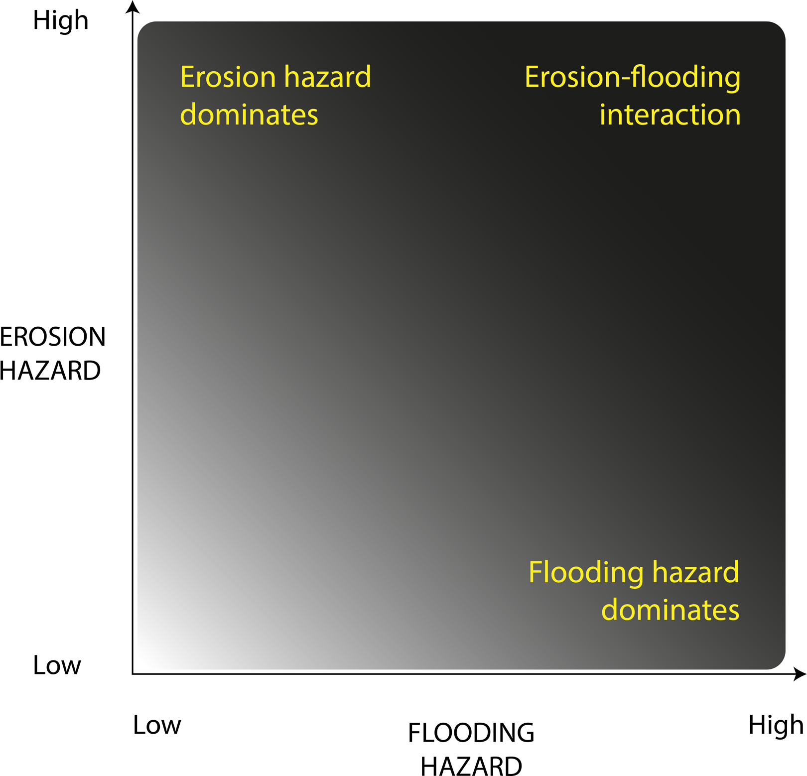
A conceptual diagram to visualise coastal erosion–flooding hazard interaction.
This review of coastal erosion and flooding literature directs its attention towards the top right corner of Figure 1, where the combination of high erosion and high flooding hazard, confers importance on erosion–flooding interaction. In doing so, this paper identifies three ‘expressions’ of the interactive erosion–flooding relationship.
Each expression is now elaborated in turn, conveying the varied nature of erosion–flooding interactions and the necessity of addressing these risks jointly to enable effective coastal management.
1 Coastal morphology modifies flood hazard
Coastal morphology refers to co-evolution of the coastal zone and the hydrological, atmospheric, terrestrial and anthropogenic processes responsible for contemporary coastal character. The unique combination of processes at any one point in space gives rise to locally-specific morphologies. Additionally, temporal changes in these processes, and their relative importance, means that coastal zone morphology alters through time. Coastal erosion is one example of morphological change and its spatial and temporal manifestations have implications for flood risk.
The influence of morphology on spatial variation in coastal water levels is well known on low-lying sedimentary coasts (e.g. role of coastal wetlands in surge attenuation in Louisiana, Gulf coast (e.g. Loder et al., 2009) and Chesapeake Bay, mid-Atlantic coast, USA (Glass et al., 2018). On cliffed coasts, the linkages between beach morphology and cliff erosion are important as changes in beach level affect water levels at, and wave energy flux to, the cliff toe, and hence cliff retreat rates, in both hard rock (e.g. SW Peninsula, UK: Earlie et al., 2018) and soft rock (e.g. Suffolk coast, UK: Brooks et al., 2012) settings. The localised nature of these controls was well illustrated following Cyclone Xaver which impacted northwest European coasts in December 2013. High resolution surveying of 250 points along the 45 km barrier coastline of England’s North Norfolk coast revealed variation in the importance of coastal setting in determining maximum water level heights associated with Xaver’s storm surge; at one location, maximum heights varied by 1.91 m between an embayment open to the sea and a comparatively sheltered pine forest dune slack (Spencer et al., 2015). Such observations may help validate models seeking to resolve alongshore variations in maximum water heights. For example, Lewis et al. (2011, 2013) developed a storm surge model that incorporates the spatial variation in surge peak water levels as observed in local tide gauges. These data were then used to interpolate water levels for locations between tide gauges where observational information was lacking. Due to a lack of storm tide height data between tide gauges, validation relied upon synthetic aperture radar (SAR) imagery from which shoreline position was extracted (Lewis et al., 2013). The value of modelling water level differences between tide gauges was demonstrated by the SAR imagery which recorded differences up to 70 cm between beaches of differing orientation (Lewis et al., 2013). Future work seeks to apply the validated model to predict maximum water height variations for future storm events. At present, predictions of future extreme water levels are characterised by high levels of uncertainty (Wahl et al., 2017), both because the records themselves are based on single point gauge locations (Brakenridge et al., 2013) and because different statistical methods (annual maxima, r-largest and joint probability) cope differently with data frequency, length, paucity, and the treatment of tidal and non-tidal components of extreme water levels (Haigh et al., 2010). Extreme water level modelling, carefully validated by high spatial resolution observations, is an important step in quantifying and ultimately reducing this uncertainty.
Establishing how temporal changes to coastal morphology modify flood risk is a substantial challenge given the lack of datasets characterising historic coastal morphology. The impact of Cyclone Xaver on England’s east coast and high resolution water level surveying thereafter provides an opportunity for comparison with the 1953 storm surge (Spencer et al., 2014, 2015). It is noted that during the 60-year period between these events, and in certain locations, the natural pathways between the surge and receptor changed considerably (Spencer et al., 2015). Examples from England’s east coast include changes in coastline orientation, ness dynamics and offshore bank growth and decay (Brooks and Spencer, 2010). Associated release of sediment to the nearshore zone and modification of nearshore bathymetry has the potential to influence water depths, wave run-ups, and resultant water levels (Spencer et al., 2015). However, the challenge of attributing water level differences to natural morphological change alone is complicated by variation in the respective characters of the two events, changes in mean sea level over 60 years, and changes to the artificial coastal defences, primarily in the form of extensive raising and strengthening of clay embankments after the catastrophic UK east coast storm surge of 1953 (Baxter, 2005). It is important to recognise that morphological change does not occur in isolation of the coastal management regime to which it has been subjected. This is especially relevant to English coastlines at present given the focus of second-generation shoreline management plans on managed realignment rather than hold the line approaches (Defra, 2006).
Numerous morphological features likely contribute to spatial and temporal water level differences. One area of progress in quantifying the relationship between morphology and water levels is the interaction between hydrodynamics and vegetated intertidal and supratidal platforms. Building on work that has established the wave attenuation potential of vegetation under ‘normal’ conditions (Mazda et al., 2006; McIvor et al., 2012a; Möller, 1999; Möller and Spencer, 2002), there is a growing body of work that looks at how habitat types may contribute to surge attenuation (McIvor et al., 2012b; Möller et al., 2014; Paul et al., 2016; Spencer et al., 2016). This suggests that the return period in a given locality may also change. It is conceivable, for example, that deterioration of a protective saltmarsh results in a 1:100-year event today occurring with greater frequency in the future. Changes to these local return periods are far less predictable than those resulting from sea level rise, and, arguably more important given that flood impacts are ultimately felt at a local scale. Finally, there is evidence from the past for such changes. Thus, for example, and in the context of the evaluation of the return period for superstorm Sandy (Brandon et al., 2014), numerical modelling, sediment core stratigraphy and historical records all support the argument that the loss of extensive oyster reefs was the most likely cause of increasing storm overwash sedimentation in the in the outer harbour New York between 1600 and 1800. These results suggest that Staten Island is currently experiencing between 30% and 200% higher wave energy from extreme storms than was the case prior to oyster reef destruction (Brandon et al., 2016).
2 Future flood hazard depends on shoreline position
Coastal flooding events occur on a timescale of hours to days, and we have already seen that through interaction with shoreline morphology, flood magnitudes can be significantly altered by spatially specific and temporally variable morphological change. Therefore, to determine future flooding hazard requires information about the future shoreline that any given flood-generating event will encounter (Grilli et al., 2017).
Numerous studies have analysed historic shoreline change with a view to forecasting future shoreline position (Crowell et al., 1997; Davidson et al., 2017; Moore et al., 2006; Spirandelli et al., 2016). Brooks and Spencer (2012) evaluated a range of shoreline response models using historical shoreline change data (Brooks and Spencer, 2010) for cliffed sections of the Suffolk coast, England. Modelled cliff retreat rates in response to expected sea level rise acceleration led them to suggest sediment release for this region during the twenty-first century could reach 300,000 m3 a−1 (Brooks and Spencer, 2012). Building on this work, a subsequent study identified decadal periods of accelerated retreat which could be correlated with variations in the North Atlantic Oscillation (NAO), suggesting an important role for storms in the observed change (Brooks and Spencer, 2014; Hurrell, 1995). Elsewhere, establishing robust relationships between forcing variables and morphological responses has proven more challenging, lending weight to the suggestion that certain criteria (high quality datasets, including a quantitative record of sediment budget and large signal:noise ratio) must be satisfied to enable informed forecasting (Burningham and French, 2013; Esteves et al., 2011; Thieler and Danforth, 1994).
One of the earliest studies to integrate erosion-driven morphological changes with flood risk also focussed on the East Anglian coast where rapid cliff erosion releases large quantities of sediment into the nearshore zone (Dawson et al., 2009). Here, morphological connectivity of the coast, facilitated by longshore sediment transport, means that this sediment provides a degree of buffering from storm-driven tidal flooding (Dawson et al., 2009). A key challenge going forward surrounds attributing specific nearshore sediment accumulations to specific regions of cliff retreat. Even at the location of cliff retreat (and depending on the location of risk receptors), flooding risk will not necessarily increase. In some locations, cliff retreat gave rise to increased cliff height (from 11 m in 1947 to 15.5 m in 2008 at Covehithe), for example (Brooks and Spencer, 2010). Placing such findings within the broader flood system, Dawson et al. (2015) advocate an ‘integrated systems approach’, through which it is possible to establish how global climate trends may influence the local relationship between erosion and flooding. More recently, and with a focus on the flood event itself, Grilli et al. (2017) acknowledge that a 1:100-year event is equally likely to happen this year and in 100 years and that in each instance, the storm will interact with a different shoreline position and morphology. In reality, taking sea level rise into account, the 1:100-year return water level today will occur with greater frequency in the future (Vitousek et al., 2017), lending further support for this kind of shoreline forecasting approach. Dealing specifically with a section of barrier coastline on the US eastern seaboard, Grilli et al. (2017) simulate future shoreline position under a range of sea level scenarios. Furthermore, to provide some indication of morphological change, they consider a series of possible ‘dune states’ (intact, eroded, retreated or drowned) at the point of event impact. Holding sea level rise constant, erosion of the dune ridge is found to result in a 20% increase (compared to a scenario in which dunes remain intact) in the proportion of houses suffering damage during a 1:100-year flooding event. These figures rise to as high as 55% when sea level rise, dune recession and dune erosion are jointly considered (Grilli et al., 2017). Through inclusion of both recession and dune state, the study indicates that both shoreline position and morphology exert important influences on flood risk.
For Grilli et al. (2017), considering erosion and flooding risks jointly can alter risk assessment outcomes. This suggests that there is value in developing generic frameworks to encourage joint erosion–flooding risk assessment. Such a framework was developed and applied regionally across Europe by the RISC-KIT (Resilience Increasing Strategies for Coasts) project. RISC-KIT attributes explicit attention to the interactive nature of erosion and flood risk through its coastal regional assessment framework (CRAF) (Viavattene et al., 2018). CRAF consists of two phases: Phase 1 seeks to broadly identify erosion and flooding hotspots at the regional scale, followed by Phase 2 which implements detailed modelling at the hotspot locations themselves (Viavattene et al., 2018). This is exemplified for the Tordera River Delta, Spain (Jiménez et al., 2018). Having identified ‘highly sensitive’ areas, deemed to be vulnerable to both storm-induced flooding and erosion (Phase 1), Jiménez et al. (2018) employed the X-Beach numerical model (Roelvink et al., 2009) to simulate the two hazards (Phase 2). The interaction of erosion and flooding is illustrated through comparison between a partially sheltered, low elevation southern beach and a more exposed northern beach. The shelter granted by the orientation of the southern beach reduced storm-driven erosion, and yet the low elevation meant that overwash remained a frequent occurrence. In terms of flooding, orientation of the southern beach resulted in wave direction exerting a relatively greater influence compared with the northern beach, which was prone to flood regardless. Furthermore, this event-scale analysis was placed in the broader context of chronic erosion that had seen beach retreat over the past forty years, removing a vital protective buffering function and increasing the exposure of onshore settlements and infrastructure to extreme events (Jiménez et al., 2018).
3 Simultaneous erosion–flooding events
Elevated water levels are required for coastal flooding to occur, particularly where coastal hinterlands are fronted by defence structures. Given that elevated water levels tend to be associated with high-energy hydrodynamic conditions, erosional impacts are likely to coincide with coastal flooding events. This represents an instantaneous alteration to the SPRC framework. Establishing erosion–flooding interactions during these events is especially important given that low frequency, high magnitude events can possess disproportionate erosive and flooding potential (Callaghan et al., 2009). Phillips (2014) refers to geomorphic state transitions, suggesting the existence of threshold(s) within the geomorphic system that must be surpassed to deliver state change (Schumm, 1973, 1979). An important, albeit largely unanswered, question is how threshold exceedance and resultant state change maps onto coastal erosion and flood risk.
One example of morphological threshold exceedance with implications for flood risk is barrier breaching. Such breaching occurs when the barrier ridge is eroded to such an extent that a new channel is formed between the open-water seaward side and the back-barrier bay (Davis et al., 1989). Breaching events are sometimes preceded by or associated with overwash in which sediment is transported from the seaward, over the crest, to the landward side (Schwartz, 1975). Breaching and overwash represent a direct pathway through which water flows can propagate, resulting in potentially increased water levels in back-barrier areas representing a source of flood hazard for landward receptors. Numerous morphological controls on barrier breaching and overwash have been identified (Hayes, 1979; Leatherman et al., 1977; Sallenger et al., 2006). For example, the importance of foredune morphology is demonstrated by the predominance of washovers where the dune ridge is lower and more likely to breach (Houser et al., 2008; Orford et al., 1995; Schwartz, 1975; Suter et al., 1982). Implications in terms of flood risk have inspired (largely descriptive) reports dedicated exclusively to barrier breaching from the US Army Corps of Engineers (Kraus and Wamsley, 2003, 2005). However, few studies have established whether breaching and overwash during an event directly increases the resultant flood risk. Those that have done so tend to apply numerical modelling techniques to the problem. Cañizares and Irish (2008) modelled two historic coastal storms that caused widespread overwash, breaching and landward flooding at Long Island, New York. They simulated the 1938 storm surge event responsible for the opening of the Shinnecock Inlet which persists today, finding that the model reproduced the opening of the inlet at the same actual time as maximum water levels in Shinnecock Bay. Comparison to a model run in which morphological change was ‘switched off’, revealed that barrier island overflow (resulting from breaching and overwash) contributed 0.75 m to the total water level of the bay. Grzegorzewski et al. (2011) also deployed a modelling approach to quantify the potential impact of restoring the Plaquemines and Ship Island barriers in the Gulf of Mexico. They suggest that, if restored, additional water flow over the barrier crest during a surge event would decrease by 40% and 60% respectively compared to an unrestored scenario.
One of the challenges of jointly analysing erosion and flooding risks is the need to harmonise quantitative and qualitative datasets of varying type, structure and accuracy. This is an area where Bayesian networks have been shown to perform well (Poelhekke et al., 2016; Uusitalo, 2007). Plomaritis et al. (2018) trained a Bayesian network to incorporate both overwash (flooding) and erosion hazards for a barrier island setting. They found that erosional impacts were only significant during extreme events. Attempts to explain when such changes occur have led to the identification of storm threshold characteristics for a given coastal area. This was achieved for the Belgian coast using a 24 year record to suggest that storms characterised by a significant wave height of >4 m, water level >5 m and duration of >12 h were likely induce significant morphological change (Haerens et al., 2012). Establishing storm characteristic thresholds such as these is important given that a lack of erosional impacts during moderate ‘below-threshold’ events might lead coastal managers to neglect this hazard, leading to maladaptation to more extreme water level events capable of delivering both erosion and flooding.
III Discussion
This paper presents an explicit treatment of the interactive relationship between erosion and flooding with implications for future management and research. The expressions elaborated above illustrate strong interactive relationships between erosion and flood risk. Erosion–flooding interactions can be represented as a spectrum of intensity mediated by the coastal setting in question (Figure 2). For example, when considering very short timescales and chronic inundation threat, there may be insufficient energy intensities for extensive erosion to occur. Alternatively, on hard-rock coasts, erosional change may occur extremely slowly by comparison to flooding events. Elsewhere erosional processes may have been artificially halted by extensive coastal engineering. The dominant effect of structures such as movable barriers on their morphological setting is likely to present unique erosion–flooding interactions that must be considered in the light of defence longevity. Erosion risk may also persist in the absence of significant flooding risk, for example, where rapid retreat of high cliffs dominates the landward environment. Furthermore, given that this paper has only considered a limited number of case studies, it is likely that numerous other expressions of erosion–flooding interaction exist with lesser or greater dependence on specific coastal settings. Given the complexities of erosion–flood interactions and the time and skill investments required to unpack them, a precursory assessment of the degree of interaction is a valuable starting point.
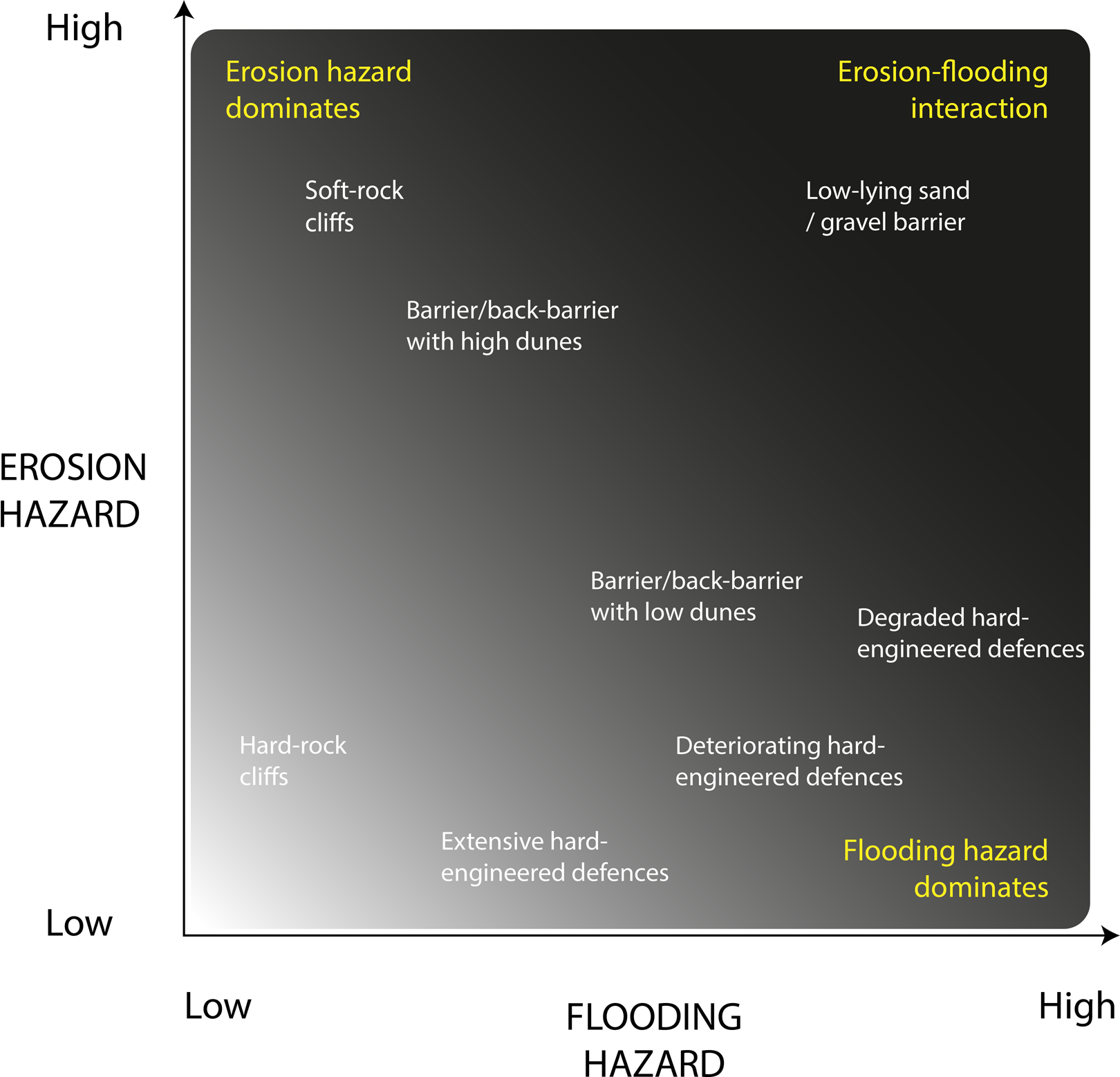
Coastal erosion–flooding hazard interaction diagram populated with representative coastal settings.
Coastal zones have been described as displaying strong human-landscape interactions which give rise to instabilities in the response of the coastal zone to forcing, such as from sea level rise (Lazarus, 2014; Lazarus et al., 2016; McNamara and Werner, 2008). It is therefore possible to conceptualise erosion–flooding interactions as occurring in the broader context of human–landscape interactions in which risk receptors exert a degree of agency over the hazards to which they are exposed. Two critical insights stand out as priorities for the development of coastal risk management policy. First, is the recognition that future extreme events will encounter future coastal morphologies that may differ significantly from the present. When combined with modelled extreme sea levels, the inclusion of (possible) future shoreline characteristics enables an assessment of future erosion–flooding interactions without the simplifying assumption of static shorelines. Second, is the reality that erosion and flood risk is determined and experienced at the local scale. This supports approaches to coastal risk assessment that address nested scales, by identifying hotspots of risk at coarser national or regional scales which then feed into more detailed local scale assessments.
IV Conclusion
Erosion and flooding risks are often analysed separately owing to complex relationships between driving processes, morphological response and risk receptors. We argue that these risks should be considered jointly as illustrated through discussion of three ‘expressions’ of this interactive relationship. This interactive relationship is expressed when: coastal morphology modifies flood hazard; future flood risk depends on future shoreline position; and the simultaneous occurrence of erosion–flooding events. While the argument here has focussed on instances when the coupling of erosion and flooding is relatively strong, we also recognise that this viewpoint is mediated by individual coastal setting. Furthermore, it is necessary to consider the relationship between human activities at the coast and how this may influence the strength of erosion–flooding interactions, both now and in the future. These insights have clear relevance to coastal risk management policy and should be incorporated where necessary. This will ensure that policy reflects the complexities of coastal change and acknowledges the implications of this change for future coastal erosion and flood risk.
Footnotes
Declaration of conflicting interests
The author(s) declared no potential conflicts of interest with respect to the research, authorship, and/or publication of this article.
Funding
The author(s) disclosed receipt of the following financial support for the research, authorship, and/or publication of this article: This work was funded through the NERC/ESRC Data, Risk and Environmental Analytical Methods (DREAM) Centre, Grant/Award Number: NE/M009009/1.