
Abstract
This paper introduces the concept of “bypass urbanism” to account for a process of urbanization that is reordering center-periphery relations of urban regions into new hierarchies. Bypass urbanism became visible through a comparison of large-scale urban transformations at the peripheries of Kolkata, Lagos, and Mexico City by zooming out and considering their impacts on the socio-spatial structure of the extended urban regions. Bypass urbanism is not emerging from the construction of a singular new town or real estate project, but is the result of the simultaneous development of an ensemble of various independent but related projects. Therefore, bypass urbanism usually does not emanate from a coherent planning initiative, even less so from a hidden “master plan” at the hands of any single developer or state agency, but it emerges through a convergence of interests over large areas of land at the geographical periphery of urban regions that have been made available for new urban developments by various measures. We understand bypass urbanism as a multidimensional process that includes material-geographical bypassing, the bypassing of regulatory frameworks, and socio-economic bypassing in everyday life. It results in the creation of exclusive and excluding spaces that enable middle and upper-class lifestyles, at the same time leading to the peripheralization of extant urban areas that are bypassed and neglected. The massive scale of bypass urbanism that we have observed represents a new quality of urban development resulting not in isolated urban enclaves or archipelagos, but in the fundamental restructuring of the extended urban region with far reaching and incalculable repercussions.
Keywords
Introduction
Something astonishing is happening in the urban peripheries, or what were once the peripheries, of Kolkata, Lagos and Mexico City. Developments such as highways, airports, tunnels, toll roads and bridges, private schools, universities and hospitals, business districts, office complexes, industrial parks, malls, gated communities, condominium towers, luxury residences and other real estate projects of various scales have been rapidly built in the past decades over huge areas that once were sparsely settled agricultural lands, wet lands, nature reserves, terrains vagues or even contaminated areas and dumpsites at remote locations of the three urban regions. The massive scale of these transformations became apparent in our research through a comparison of the these extended urban regions, and particularly through mapping, which revealed situations that are not easily visible from the ground alone. In each of these urban regions, we observed conglomerations of large-scale real estate megaprojects, new centralities and newly constructed urban infrastructure in certain sectors of the urban periphery resulting in huge affluent and exclusive urban zones that are bypassing the extant urban areas. We name this process “bypass urbanism”. Similar terms have already been used, such as “bypass-implant urbanism” (Shatkin, 2008) and “bypass approach to urbanization” (Bhattacharya and Sanyal, 2011) to characterize certain aspects of individual large-scale urban projects at the urban periphery. We use “bypass urbanism” here to conceptualize an urbanization process that goes beyond the reach of even the largest new town or urban megaproject, with impacts that extend to a regional scale, reorganizing and reconfiguring entire urban regions.
Until recently, analyses of such urbanization processes have focused mostly on individual projects. In Mexico City, Santa Fe has been mainly analyzed as an emergent business district, and the adjacent neighborhood Interlomas is famous for the proliferation of gated communities (Jones and Moreno‐Carranco, 2007; Parnreiter, 2011; Tamayo, 2001; Valenzuela, 2007). In Lagos, the rapid urbanization of the Lekki corridor between Lekki Phase I estate and Epe, is gaining increasing attention for its private housing estates, violent forced evictions and negative environmental effects (Heinrich Böll Stiftung Nigeria, 2014; Lawanson and Agunbiade, 2018; Uduku, 2010). The adjacent new town Eko Atlantic is noted as one of the new “megaprojects” of sub-Saharan African cities (Mendelsohn, 2018; Murray, 2015; Watson, 2014). In Kolkata, there is a growing literature on the “new town developments” of Salt Lake and Rajarhat New Town (see e.g. Das, 2020; Dey et al., 2016; Rumbach, 2014, 2017; Sen, 2017). However, these projects need to be embedded in a comprehensive analysis of the extended urban region by scrutinizing the combined effects of new transport connections and the interplay of various megaprojects which are transforming entire sectors of the urban periphery into a kind of new ‘parallel city’ that bypasses large parts of each urban area under study. These findings were stimulated by the decentering perspective of the concept of planetary urbanization (Brenner and Schmid, 2015; Schmid, 2018): by positioning ourselves not in the center of the urban areas, but at the peripheries, it was possible to invert the usual centripetal perspective and to look from emerging urban territories on the outskirts towards the extant urban center.
The conceptualization of bypass urbanism presented here is an outcome of a research project that systematically compared urbanization processes in eight large urban regions: Tokyo, Kolkata, Hong Kong/Shenzhen/Dongguan, Istanbul, Lagos, Paris, Mexico City and Los Angeles (Schmid et al., 2017). The goal of this project was to propose a new vocabulary of urbanization, which could allow a more nuanced analysis of urbanization processes. Our comparative strategy was strongly inspired by postcolonial approaches and the new comparative urbanisms (see e.g. Robinson, 2004, 2016; Roy and Ong, 2011). At the same time, we drew on the process-oriented epistemological perspective offered by planetary urbanization, and were informed by Lefebvre’s theory of the production of space (see Lefebvre, 1991; Schmid, 2014, 2015). The methodology was based on iterative rounds of field research in each urban region by individual researchers, applying mobile and multi-sited ethnography, interviews with inhabitants and a comprehensive consideration of a broad local scholarship, (Kallenberger, 2018; Sawyer, 2016; Streule, 2016, 2018, 2019a). Mapping was a key tool of comparison, as it allowed us to move analytically and imaginatively across different contexts to identify emergent similarities. Mapping sessions with local experts helped to identify the key characteristics of each urban region. They were complemented by mixed data from a variety of sources including participant observation and census data. This information was integrated through triangulation to produce a mapping of each urban region that showed areas where certain urbanization processes were dominant. We used these maps as heuristic devices in the comparative procedure. We finally identified and conceptualized a series of new urbanization processes through a total of twelve intensive comparative workshops of one to two weeks each involving the entire research team (for a more detailed account on the methodology see Schmid et al., 2018). Bypass urbanism is one such specific urbanization process that emerged in our comparison in three of our eight case studies, namely in Kolkata, Lagos and Mexico City. In the following, we will explore the characteristics of bypass urbanism and propose an analysis which we see as a revisable conceptualization, open to further examination and discussion.
Lekki corridor and Eko Atlantic in Lagos, Rajarhat and Salt Lake City in Kolkata, Santa Fe and Interlomas in Mexico City, together with a range of infrastructural projects constitute almost huge parallel cities on their own. The maps of the bypass processes (see Figures 1 to 3) reveal the scale of peripheral transformation. It looks almost as if a ‘new city’ is coming into existence that is bypassing the existing urban areas, in terms of the material structure of the urban fabric, territorial regulations, and socioeconomic characteristics. It is thus our hypothesis that the entire urban region is being reconfigured through the production of various emerging centralities and new transport networks with a resulting off-centering of the urban structure. The emergence of heterogeneous but powerful alliances of various state and private actors and the concomitant transformation of regulatory systems are also shaping and defining a process of urbanization that bypasses conventional modes of urban and regional governance. Our study shows that these actors are not following a clear, predefined master plan or overarching strategy, but rather that a certain logic of capital accumulation and commodification is resulting in a new kind of urbanism that affects people inside and outside the bypass areas. The comparison of these three very different contexts suggests that the process also leads towards a peripheralisation of other parts of the urban region as socioeconomic inequalities are deepened and enshrined in the reordering of the urban fabric.
The following section will explore the idea of “bypassing” in the emerging literature on urban megaprojects and new towns in large and fast-growing ‘southern’ urban regions. We focus particularly on the deepening of sociospatial segregation and the reinforcement of socioeconomic inequality; the transformation of planning practices to incorporate complex alliances of actors in the public and private sectors; and the increasing role of (global) corporate power and private investors in the urbanization process. We will then develop our specific understanding of bypass urbanism by bringing together a range of aspects to conceptualize a multidimensional process of urbanization. The following sections will present detailed discussions of bypass urbanism in Kolkata, Lagos and Mexico City, which the final section will draw together to propose a more detailed and nuanced definition of bypass urbanism.
Urban megaprojects and new towns: Bypassing as metaphor in urban studies
Large-scale urban developments in urban peripheries are not a new phenomenon. They have been framed through terms such as “new towns” and “satellite towns”, usually without distinguishing whether they are state or privately built, or considering their specific spatial forms and concrete locations in the respective urban regions (see Gotsch, 2009). As Murray (2017: 55) pointed out, such concepts were originally deeply rooted in modernist planning principles, which aimed at taming and controlling the chaos of urban life and the haphazard mixture of people and situations in large metropolises: new planned towns at the urban periphery should create ideal urban landscapes with a rational order imposed by professional expertise and legitimized by public authority. In the last decades, however, the character of such urban megaprojects profoundly changed. In the context of neoliberalized urban governance, they are increasingly developed as privatized and gated “luxury enclaves”, reflecting world class aspirations of real estate developers and corporate elites (Murray, 2017: 165). They are usually located at geographical peripheries, clearly and intentionally segregated, attract new urban middle classes and exclude other parts of the population. Developers sell an image of prestigious and exclusive, modern, healthy lifestyles in highly securitized, green surroundings, for which there is a growing demand (see e.g. Datta and Shaban, 2017).
The metaphor of bypassing is alluded to in various contributions on these developments. Chakravorty (2000: 71) stated that Kolkata’s New Towns Salt Lake and Rajarhat would “bypass the city’s ills – poor infrastructure, slums and poverty”. Referring to Jakarta, Firman (2004: 358) highlighted the choice many people make to move to a new town reflects a desire for new modes of everyday life, separate from, but close to, the amenities of the existing city, thus avoiding congestion, pollution and lack of space. For Metro Manila, Shatkin described a “bypass-implant urbanism” understood as an “imperative of the private sector to seek opportunities for profit by cutting through the congested and decaying spaces of the ‘public city’ to allow for the freer flow of people and capital and to implant spaces for new forms of production and consumption into the urban fabric” (2008: 388). By analyzing new towns on the outskirts of major urban regions in India, Bhattacharya and Sanyal (2011: 42) observed the emergence of a “bypass approach to urbanization” where “older metropolitan centers are ceded to the existing mix of wealth and squalor, while new towns are developed as the location of a new economy and a new class of producers and consumers” with the consequence that people are thereby displaced to make way for the new urban elites. Rumbach (2014: 118) writes of Salt Lake in Kolkata that “this ‘bypass urbanism’ seeks to create new zones of exclusivity, where urban elites can, from a comfortable distance, enjoy the amenities of the metropolis, and its informal labor force”. However, as various researchers have observed (see e.g. Bhattacharya and Sanyal, 2011; Datta and Shaban, 2017; Rumbach, 2014; Shatkin, 2008, 2017), the advertised and desired modes of segregation might undergo significant transformations in the wake of the translation into reality: there are a range of contradictory effects such as new towns worsening the commuter congestion they are supposed to alleviate and escape, or built forms that do not live up to shiny brochures, and plans that are only partially implemented. These “urban fantasies” (Watson, 2014) collide with the deep poverty of everyday realities and emergent economic and financial crises, and entire new towns remain unfinished and appear more like ghost towns than new middle-class paradises.
The construction of new towns usually reinforces uneven urban development and uneven access to public infrastructure, reconfiguring the urban fabric and exacerbating sociospatial inequality and segregation (Wang et al., 2010). These large-scale projects are seen to divert public (and potential private) investment away from the existing urban areas and its lower income groups, compounding the problems that arise from longstanding infrastructural deficiencies (Bhattacharya and Sanyal, 2011; Firman, 2004; Ghertner, 2014; Shatkin, 2008; Siemiatycki, 2011). The market-driven rationality of these developments (for example privately-funded toll roads) gives privileged access to those who can afford the associated charges of use for accessing purportedly public services (Ong, 2006). As enclaves built by profit driven and politically influential actors, these projects exhibit an inherent tendency toward exclusion and elitism, as developers seek to create self-enclosed spaces of corporate capital accumulation (Shatkin, 2017: 214). These mechanisms are working to widen pre-existing socioeconomic disparities, and while sociospatial segregation is not new in most of these urban regions, it is being reinforced on an unprecedented scale by the development of such new towns (Datta, 2017; Firman, 2004; Garrido, 2013; Shatkin, 2008; Wang et al., 2010).
These large-scale urban projects can only be realized with new modes of urban governance, in which privatized regulatory regimes shield wealthy enclaves from public oversight and interference, leading to an “urbanism of exception” (Murray, 2017). Such projects often violate existing master plans and land use plans, and are very poorly executed with only short-term profit-oriented goals in mind. Many researchers observe the increasing power of (global) private developers in urban and regional planning, and the reconfiguration of public-private sector relationships to implement large-scale developments, what Shatkin (2008) called “the privatization of urban and regional planning”, and Garrido (2013) “corporate planning”. In China, state entrepreneurialism promoting urban projects on the outskirts of major urban regions has been a prominent theme for quite some time (Lin, 2014; Shih, 2017; Wu and Phelps, 2011). In a more general way, Shatkin (2017: xiii) identifies a “real estate turn” in urban politics as a result of a range of reforms in urban governance, land management and state-community relations, whereby state actors play a much more active role in the mobilization of land for urban development as a means of power and authority. He raises the hypothesis that in an era when state actors face intense fiscal constraints and are exposed to vacillations of global investment and finance, they are increasingly seeking to exploit opportunities to monetize urban land. He sees these tendencies as the result of a convergence of state, corporate and real estate interests leading to new strategies of rent seeking and land commodification (Shatkin, 2017: 214).
These new modes of governance involve controversial methods of land acquisition, which are often seen as masking predatory land grabs. In order to consolidate large tracts of land, state actors and private developers often apply unscrupulous and unfair strategies, against which local actors are relatively powerless and disorganized (Bhattacharya and Sanyal, 2011; Firman, 2004; Ghertner, 2014; Rumbach, 2014). Sometimes violent displacement of residents living and working in the area can become a major source of conflict, leading to various forms of resistance, contestation and subversion (Shatkin, 2011; Wang et al., 2010). While megaprojects are usually justified as bringing economic growth, environmental sustainability, and the provision of much-needed infrastructure, there is little accountability for achieving these goals, and even less so for the evaluation of long-term effects (Datta, 2017). It is important to acknowledge that the concrete social and environmental impacts and the roles of various actors involved in the development process vary hugely in different contexts and must be carefully differentiated (see also Hogan et al., 2012: 61).
The scholarly work discussed so far predominantly refers to discrete urban developments, such as specific real estate or infrastructure projects. While the massive restructuring impacts of such projects are often clearly seen and stated, most analyses focus on individual projects that are often treated as isolated islands – as terms such as “satellites”, “new towns”, or “luxury enclaves” clearly indicate – while the broader spatial context is often not analyzed. Only very recently has the larger territorial scale of urban development come into perspective. Thus, Datta and Shaban’s (2017) edited volume presents various observations about the emergence of unprecedented modes and scales of peripheral transformation in urban regions in Asia and Africa. These new urban zones, which they term “fast cities” emphasizing the rapidity of development, materialize at the scale of regional urbanization. They bypass the pressing challenges of existing megacities, and may lead to the development of urban mega-clusters and new industrial corridors (Datta, 2017: 9).
Throughout the literature discussed here, the notion of “bypass” appears quite often as a metaphor, mostly in the sense of bypassing planning instruments and territorial regulations, local actor constellations, and existing modes of everyday life. During our own comparison of Kolkata, Lagos and Mexico City, we came to the notion of bypass urbanism in a much more literal sense. We used it to describe the material urbanization process unfolding along the Eastern Metropolitan Bypass in Kolkata, which became the backbone of the development of a large urban corridor of varying width including new shopping malls, private hospitals, business centers and condo towers. The obvious result of this kind of urban development is not the production of an isolated enclave or an archipelago of wealth and luxury, but a fundamental restructuring of the entire urban region with far reaching and incalculable repercussions. Therefore, we extend the range of meanings expressed by the term “bypass urbanism” to conceptualize a multidimensional urbanization process that includes material-geographical bypassing, bypassing of territorial regulations and socioeconomic bypassing in everyday life.
Bypass urbanism involves the realization of a series of projects that together initiate the development of an entirely new urban configuration at the edge of an urban region. This includes new infrastructures such as airports, ports, highways, tunnels, toll roads and bridges; urban amenities such as private schools and hospitals, malls, private universities, golf courses, recreation facilities; as well as real estate projects, new towns, technology centers etc. All these projects together have the effect of materially bypassing the extant urban area. In this way, a fundamentally new model of urbanization is introduced (unevenly) into the extended urban region. In order to be implemented, the production of these large-scale urban projects usually cut short or circumvent existing territorial regulations and planning procedures and/or take advantage of certain ‘flexibilities’ and legal ‘grey spaces’ in the regulatory system. These projects involve alliances of various private and state actors, often expand the reach of the private sector and reinforce the entrepreneurial role of the public sector. Bypass urbanism offers an alternative to the ‘messiness’ of the existing urban space with the creation of exclusive and excluding urban spaces that enable more comfortable or prestigious lifestyles. In terms of everyday life, they bypass large parts of the urban region, reinforcing tendencies of uneven urban development, socioeconomic segregation and peripheralization.
We now discuss each of our case studies in turn, and will then return to the elaboration of ‘bypass urbanism’ as an emergent urbanization process.
The Kolkata eastern bypass: More than just a highway
Travelling from the central Bazar area to Salt Lake, we left the dense and congested urban core and drove slowly eastwards, noticing a strong gradient in urban wealth. The roads became smaller and bumpier, and the majority of vehicles changed from the yellow Tata Indigo cabs to motor- and cycle-rickshaws. Suddenly, the road turned into an unpaved track, leading through a poor popular neighbourhood. Just as we thought we were driving in the wrong direction, the scenery abruptly changed and we arrived at a highway bordered by shiny glass facades and skyscrapers under construction. We had reached the Eastern Metropolitan Bypass (see Figure 1). While the urban centre of Kolkata is slowly decaying, new projects of an immense scale and scope are emerging on the eastern urban edges. In the East Kolkata wetlands, a roughly 30 km long urban corridor has been developed from the International Airport in the North, passing the rapidly developing Rajarhat New Town and the modernist satellite town of Salt Lake and following the Eastern Metropolitan Bypass all the way to the south-eastern outskirts of Patuli Township and New Garia area. Along this corridor, hundreds of condominium towers and office blocks, and a wide range of private hospitals, shopping malls, luxury hotels, private high schools, universities and a science museum have been built. Many more such projects are under construction or being planned.
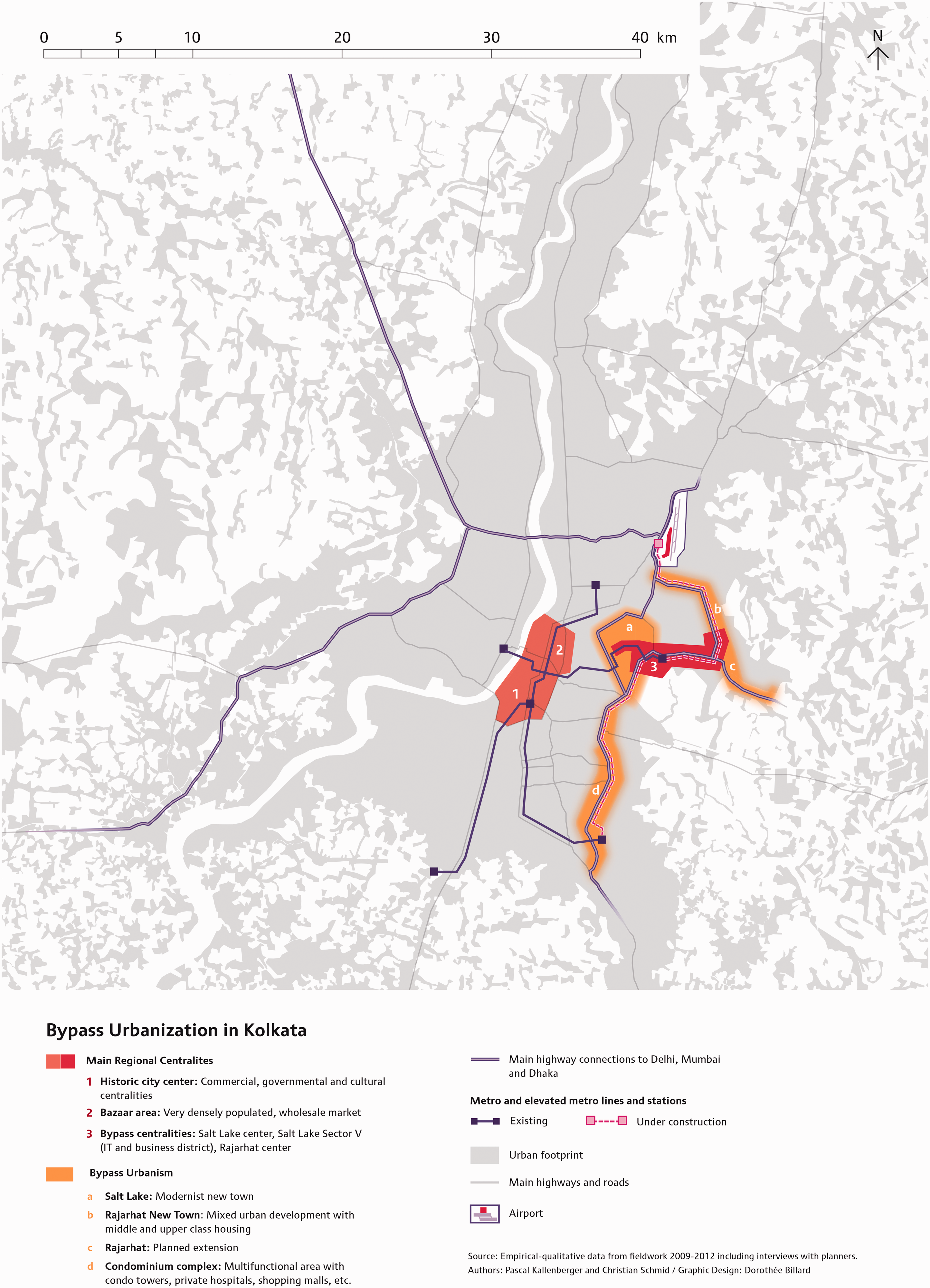
Bypass urbanization in Kolkata in relation to the metropolitan scale (map design by Dorothée Billard, based on Kallenberger, 2018).
The beginnings of Kolkata’s bypass urbanism have somehow remained obscure. Chakravorty recalls how he became aware of the existence of the Eastern Metropolitan Bypass in the early 1980s, when he took it regularly to reach his new home in Salt Lake. When his friends found out that he used the bypass – just a two-lane road then – as late as eleven at night they were “foreboding and solicitous”, warning him about “dacoits” (armed robbers) (2014: 184). The construction of the new town in Salt Lake where he lived was just in its first stage. Until the mid-20th century, Kolkata had developed mainly along the Hooghly river, one of the many distributaries of the Ganges. Towards the east, the land gently declines to marshes, jungles and tidal lakes, forming an important nature reserve, as well as an economically and ecologically vibrant region (see Bose, 2015: 91). Through a unique ecological system domestic wastewater from Kolkata is cleaned in these wetlands and becomes nutrients for the production of vegetables and fisheries (Dey and Banerjee, 2017). The first plans by the state to build an urban extension for Kolkata’s fast growing lower and middle-class population in the municipality of Bidhannagar date back to the late 1940s. They followed the tabula rasa planning model of the modernist new towns of the time, such as Chandigarh or Brasilia. Land reclamation began in 1962, the first houses were ready in 1970, but further development proceeded only slowly; it was only as late as 1981 that the population of Salt Lake exceeded 10,000, but by 2011 it had reached about 276,000 (see Rumbach, 2017: 5). Already during the planning process, multifamily apartment buildings for the middle-class were shifted towards more exclusive detached single-family houses, and plots originally intended for civic amenities and green spaces were illegally transferred to well-connected individuals and commercial developers. Furthermore, state actors were responsible for recurrent demolitions of villages and continuous evictions of hawkers and street vendors from public spaces, often with the argument that they would contradict the desired aesthetic and function of a modern and planned city (Rumbach, 2017).
From a broader perspective, this change can be seen as the result of a paradigm shift from a developmentalist towards a neoliberal or “Post-Marxist” (Sen, 2017) planning regime. From 1976–2011, the state of West Bengal was governed by the Left Front led by the Communist Party of India-Marxist (CPI-M). Its main focus was on land reform and reduction of rural poverty (see e.g. Bose, 2015: 81; Sen, 2017: 193). Urban development policies were neglected and limited to the improvement of bustees (poor tenement settlements). This changed around 1986, when internal restructurings within the CPI-M prefigured a “neoliberal turn.” 1 On a national level, this turn fully unfolded only after the strong economic crisis of 1991, when a negative Indian trade balance and a massive fiscal deficit led to a strong devaluation of the Indian Rupee, and the IMF and World Bank forced India’s government to undertake wide-ranging economic and financial “adjustments” to access emergency loans. The urban development of Kolkata was severely slowed down by this economic crisis. It had already been held back for decades by Kolkata’s weak economy, 2 and it was further hampered by a “politics of deliberate uncertainty” (Roy, 2003) in relation to landownership. This politics was used by the Left Front as a strategy for state control of urban development, in a situation where most of the urban and agrarian land was marked by multiple ownership claims(see also Shatkin, 2011).
At the beginning of the new millennium Kolkata started to catch up with the booming Indian economy and experienced strong growth in financial and producer services. As a result, the last undeveloped part of Salt Lake was developed into an IT hub. At the same time, the West Bengal government moved toward a much more ‘business-friendly’ attitude. Sen (2017: 195) mentions “Operation Sunshine”, an urban regeneration program from 1996 directed against hawkers and street vendors as a turning point. Roy (2004: 152) notes that “the New Economic Policy of the Left Front has taken hold most vigorously on the eastern fringes of Calcutta”, and that the urban developmentalism of the “new communism” remained Marxist only in its radical rhetoric while starting to enact a neoliberal agenda by bypassing its own regulations, most notably restrictions on the urbanization of agricultural land (Roy, 2004: 153). Shatkin (2017: 160) explains this policy change with the growing interest of the Left Front in fully seizing the opportunities for economic growth through land monetization and commodification of urban space in order to strengthen its political-economic influence.
After the development of several upper-income housing projects through public private partnerships the Government of West Bengal launched the Rajarhat New Town project adjacent to the IT hub in Salt Lake, on fertile agricultural lands with entrenched villages, orchards, ponds and wetlands. 3 The new town was announced as a green, eco-friendly and socially inclusive smart city in the 1993 concept plan of the Kolkata Metropolitan Development Authority. In 1999, the execution of the project was handed over to the development corporation WBHIDCO, a public private partnership between the State of West Bengal (with 51% of the shares) and private investors, which acquired the land and leased it to developers and private owners, secured funds from capital markets and built the necessary infrastructure. Based on a law from 1894, the government enforced the direct purchase of the land from farmers. The forced acquisition of the land, the lack of transparency, poor negotiations and unfair compensation which generated huge windfall profits for the government and its partners, and finally a range of forced evictions and demolitions created widespread resistance and controversies (see e.g. Das, 2020; Dey et al., 2016; Kundu, 2016; Sengupta, 2013). However, due to the piecemeal procedure of the project, and the low level of organization of the poor farmers with mostly small landholdings the new town project proceeded relatively quickly.
The Left Front’s model of land acquisition came under serious pressure in 2006, when the government of West Bengal tried to acquire about 400 hectares of agricultural land in Singur, in the north-western part of Kolkata, for the development of a factory and a related settlement for the production of the Nano, the new low-cost car of Tata Motors (see Shatkin, 2017: 157). After the project met with strong and widespread opposition of farmers, activists, NGO’s, academics, and oppositional political parties, Tata decided to relocate the factory site to Ahmedabad (Mallik, 2017). As a long-term fallout of this and other scandals, the Left Front lost its majority in the West Bengal Legislative Assembly to the new All India Trinamool Congress in 2011 (see e.g. Das, 2020; Sen, 2017).The overall plan and development pattern for Rajarhat New Town did not change substantially with the new government. The first part of about 2700 hectares is now (2020) near to completion, comprising the usual gated high-rise residential complexes, an important number of global and regional IT and real estate companies, higher educational institutes, luxury hotels and several big malls. In contrast, the second part of Rajarhat New Town still looks like a splintered and scarred landscape, with some patches of new high-rise apartment buildings, scattered construction sites and fallow lands. The proudly announced Kolkata Museum of Modern Art, designed by Swiss star-architects Herzog and de Meuron is just a building pit. The rest of the designated new town area contains 16 remaining village pockets, some recent popular settlements, agricultural lands with herds of cattle, and the last remaining wetlands and ponds (see also Basu et al., 2020; Mitra and Banerji, 2018).
There are several reasons for buying an apartment in the bypass area 4 : On the one hand, Kolkata’s emerging middle and upper middle-class residents are looking for fashionable apartments and less crowded and less noisy lifestyles. On the other hand, there are a large number of individual and corporate investors who are buying for speculative reasons. Some of them, mostly “Non-Resident Indians” living in North America or Europe, are looking for apartments as potential residences for their retirement. Others, such as immigrants from other parts of India who work for a few years in Kolkata’s IT sector are buying (instead of renting) apartments as an investment. Additionally, some companies acquire apartments as potential housing for their staff. It is telling that the luxury speculative tower developments in Rajarhat were until recently only sparsely occupied, whereas smaller condominium towers produced for the local market were sold much more quickly, particularly if developers accepted compromises with local residents (see also Shatkin, 2017 for the Bata Riverside Project).
The construction of Rajarhat New Town in an already densely populated area (with about 250’000 inhabitants in 1991, see Basu et al. (2020) had massive consequences: it led to the displacement of residents and farmers from their land and their concomitant dispossession of livelihoods (Das, 2020), to cultural marginalization (Huque, 2018), to ambivalent changes in gender relations (Dhar, 2016), and to the loss of livelihood security, and increasing dependence upon vulnerable sources of income (Mallik, 2017). Kundu (2016) shows in detail the contradictory relationships, which have emerged between the newcomers and the old-established residents in this area. Many of those who lost their land now work as servants, housekeepers, security guards, drivers or cleaners for the wealthy newcomers. Others opened shops and food stalls in front of the new office towers, or are renting out parts of their residences to poor migrants from other parts of the country: “Though villagers agreed that some job opportunities had opened up, these were few and far between and gave them little dignity” (Kundu, 2016: 97).
A similar situation developed along the southern part of the Eastern Metropolitan Bypass, where all sorts of private real estate projects mushroomed, creating massive intrusions into the wetlands with new office blocks, hotels, private hospitals and amusement parks. They could only be realised through various deals, involved the illegal landfills of ponds and lakes, and were accompanied by demolitions of popular settlements and evictions, affecting often poor migrant communities (see Bose, 2015: 91; Mukherjee and Chakraborty, 2016). Thus, a massive urban belt of about 30 km in length and varying width developed in the eastern fringes of Kolkata. This bypass urbanism is currently gaining even more traction, further propelled by the recent extension of Kolkata’s metro line 2 from the centre to Salt Lake and the construction of the new elevated line 5 along the entire Eastern Metropolitan Bypass. These investments at the urban edge are going hand in hand with disinvestment in central Kolkata, not only because of the congested urban situation, but also because many houses in the inner city have multiple ownership claims, which stall reinvestment. Urban development is thus figuratively and literally bypassing the historical centre and diverting most of governmental and private investments towards the bypass area, creating a new kind of social segregation (see also Antenucci, 2017).
As has become evident, bypass urbanism in Kolkata has not followed a predefined path. Despite the fact that the State of West Bengal took the lead, it was not guided by a clearly defined master plan and a coherent development strategy. The underlying logic of bypass urbanism in Kolkata was the political change from a developmentalist strategy focusing on rural areas towards a neoliberal urban policy. This change was not expressed in new investments in the urban centre, but materialized in the urban periphery, where new urban projects were easier to realize. Bypass urbanism was the result of several, sometimes haphazard attempts by West Bengal’s government to urbanize rural land in various locations of the urban region. While some of these attempts failed badly, others took hold. Facing strong opposition in some places, the government developed those areas where the lowest resistance occurred – in the eastern wetlands. Thus, behind the back of individual actors and state planners, a range of projects developed, resulting not in a patchwork of urban enclaves, nor in an archipelago of wealth and modernity, but condensing into an entirely new urban configuration. The Kolkata Eastern Bypass can almost be seen as a paradigmatic case of a new kind of urban corridor, bypassing large parts of the urban region with their vivid and rich cultural, political and social urban life.
The Lekki corridor: “This is Lagos!” “This is NOT Lagos!”
To leave the Lekki peninsula located between the Atlantic and the Lagos Lagoon, residents suddenly had choices: they could either take the toll Lekki-Epe-Expressway to reach Ikoyi and Victoria Island, Lagos’s major centers, or the toll Lekki-Ikoyi Bridge to bypass them to get directly to mainland Lagos, where the main part of the metropolitan region is located, as well as the city government, airport and university. This is a novel luxury in Lagos, where a chronic lack of connections across the waterways and marshy terrains has contributed to its infamously bad congestion. 5 The toll expressway from 2012 and the toll bridge from 2014 were the first major pieces of infrastructure to be built in Lagos for two decades, almost exclusively servicing the wealthier residents on the Lekki peninsula (see Figure 2).
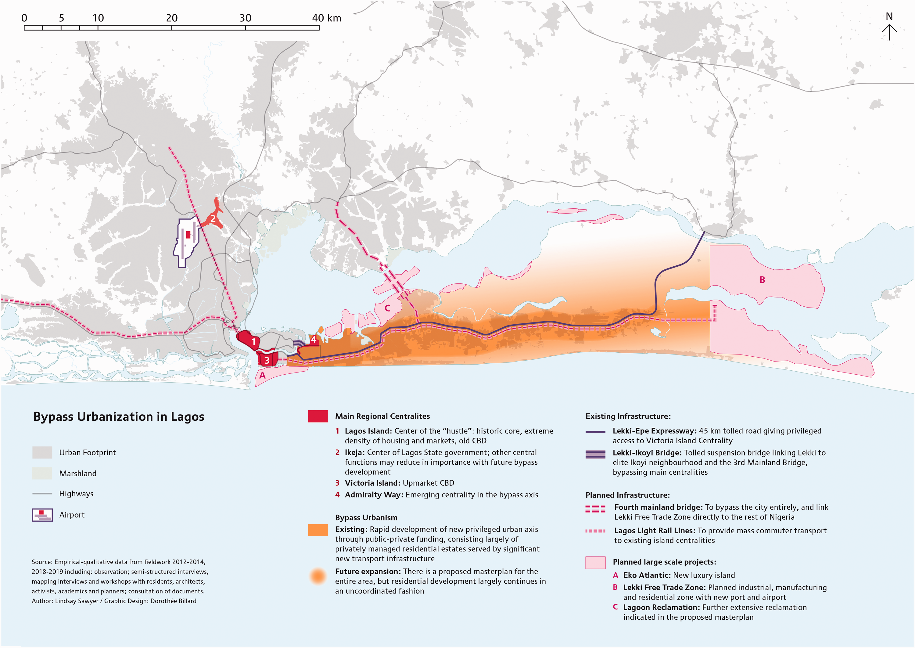
Bypass urbanization in Lagos in relation to the metropolitan scale (map design by Dorothée Billard, based on Sawyer, 2016).
Today, the Lekki corridor is of a massive scale: it stretches along the Lekki-Epe-Expressway from the settlement “Lekki Phase I”, with its high end housing estates and commercial areas adjacent to Lagos’ central islands, through the more mixed areas of Ajah and Ibeju-Lekki, to the fast growing Lekki Free Trade Zone near Epe, some 45 km down the expressway. 6 In only one decade, the Lekki corridor has become the new place for high-income private residential estates, private schools, and new industrial developments (Lawanson and Agunbiade, 2018). Lagos’s privileged areas have ballooned from small elite strongholds such as Ikoyi or Apapa in central areas to the almost open-ended expanse of the Lekki corridor. Government layout Lekki Phase I is emerging as a new centrality in its own right, and is hugely popular with Lagos’s elites and upper middle classes. This leads to an ambivalent situation where, as expressed in an exchange between a resident of Lekki and a resident of Ikoyi, the Lekki corridor can be seen as an extension of Lagos or decried as “not Lagos”: 7 On the one hand, this kind of urban development is what people have been waiting for for a long time: readily available land and housing, with direct and faster links to the centers, and with easier and more secure procedures for renting and buying houses (This is Lagos!). On the other hand, Lekki is a world away from the defining hustle and energy of Lagos (This is NOT Lagos!). From whichever perspective, this kind of urban development is changing the structure and dynamics of the entire urban region. Bypass urbanism is producing an urban fabric of a different material, regulatory and everyday logic to the rest of Lagos.
The territorial regulation in the bypass area is quite different from the “usual way” of urban development in Lagos, which we have called “plotting urbanism”(Karaman et al., 2020; Sawyer, 2016): the unplanned, plot-by-plot development of land where statutory and customary rights are intertwined in a dual land regime, causing widespread contestations and fraudulent activities over landownership, land divisions and property transfers (Sawyer, 2014). In contrast, in 2003 almost the entire Lekki corridor underwent what remains the largest government land acquisition in Lagos to date. In the acquisition, powerful traditional landowners retained some key areas of prime land and smaller traditional landowning families were able to claim back land through a process of land excision (Lagos Development Envision Lab, 2020). Thus, traditional landowners kept control of developing their land, but nominally have to comply with statutory regulations. This procedure has led to new power relations between the state and powerful landowners and to different patterns of urban development than elsewhere in Lagos. Statutory and customary landownership regimes are more clearly delineated, and the availability of large swathes of state owned or excised undeveloped land has led to the proliferation of large housing estates. Private developers do not have to go through protracted negotiations for each individual plot (as described in detail in Karaman et al., 2020; Sawyer, 2016), but can obtain legal titles for large pieces of land in one fell swoop, either directly from the government or from traditional landowners with officially excised land. Some powerful landowners with prime locations, such as the Oniru and Elegushi Families, have profited massively from developing their excised land in Lekki, even though it was only a fraction of their original holdings. 8
The Lekki peninsula is very marshy and requires much investment for infilling. It has a vulnerable topography; prone to flooding, with ocean surges on the Atlantic coast, and very serious coastal erosion that is threatening existing coastal communities (Mendelsohn, 2018). It was therefore only sparsely populated at the time of the government’s acquisition, with the exception of Maroko a vibrant popular settlement of 300,000 which was situated in the western part of the Lekki peninsula on land of the Oniru family from the 1950s until its destruction in 1990 (see also Streule et al., 2020). In the early 1980s, both the Oniru family and the government began to develop plans for the Lekki corridor, and to agitate for the clearance of Maroko. The Oniru family sought the eviction of Maroko’s residents by citing non-payment of rents and the end of a 25-year lease agreement. 9 The military government then razed Maroko in 1990 with no notice or compensation, claiming it was the source of an attempted coup (Agbola and Jinadu, 1997). The violent clearance of Maroko remains an infamous event in Lagos’s history (Soyinka, 1999), and represents a blatant example of collusion between the interests of the state and powerful customary families. Violent forced evictions have continued along the Lekki corridor until today, with one of the most recent examples being the neighborhood Otodo Gbame (Amnesty International, 2018; Mendelsohn, 2018). Lekki has become infamous once more, as peaceful protestors of the #EndSARS movement were shot and killed at Lekki toll gate in October 2020 by soldiers, allegedly sanctioned by Lagos State government (Busari et al., 2020).
However, little development happened following the clearance of Maroko due to the continuation and deepening of Nigeria’s social, political and economic crises during the 1990s. Despite the state encouraging urban development with subsidies, levies, and the release of newly acquired government land (Al-Handasah, 2011: 82), private developers and even customary landowners were reluctant to invest in Lekki, and the government had little financial capacity or political will to carry out its plans (Kuris, 2014). It wasn’t untilthe government acquisition of 2003 that the development of Lekki began in earnest. After the return of a civilian democratic government in 1999, Lagos entered a period of unprecedented stability and growth: during the course of six consecutive terms of the same political party, 10 Lagos State Government has focused on reengineering its internal sources of finance, gained access to the global financial markets and maintained an agenda of infrastructural development and public service reform (Cheeseman and de Gramont, 2017).
A further catalyst for bypass urbanism has been the construction of the new transport infrastructure. The Lekki-Epe Expressway and Lekki-Ikoyi bridge were constructed and are operated through public-private partnerships. Rapid development around the western part of the expressway on land owned by Lagos State (Lekki Phase I) and the Oniru Family (Oniru Estate) helped to jumpstart urbanization. The continuous political stability, proven commitment of the state, and visible progress encouraged a range of additional actors to invest in properties in Lekki, such as middle-class residents, the diaspora, companies seeking accommodation for their expat workers, and developers. In retrospect, bypass urbanism needed just the right conditions to flourish: available land, clear land tenure regimes, political stability, political will, a middle-class housing deficit, public financing mechanisms and more efficient tools of urban governance to enable private investment.
While the development of the Lekki corridor marks a significant departure from the usual process of urbanization in Lagos, it also reproduces some existing patterns. The same infrastructural deficiencies exist in Lekki as in the rest of Lagos: no piped water, no centralized sanitation, sparse electricity from the grid (Adedire and Babatunde, 2018). In this way, rivate developers,residents’ associations or individuals are responsible for infrastructure provision in their estates. Additionally, despite being under stronger government control and receiving more investment, the effects of poor planning are painfully obvious: building regulations and development controls are frequently circumvented; natural drainage channels are often blocked contributing to bad flooding; many roads, even in the government schemes, are still unsurfaced; and the Lekki-Epe Expressway is already clogged with congestion.
Nevertheless, Lekki offers the possibility of a relatively high quality of living and a desirable lifestyle for those who can afford it. The expressway, the choice of housing, and new centralities are making Lekki into an extremely privileged location. The Lekki-Ikoyi Bridge has a particularly strong impact: it is hugely popular with residents as a photogenic icon and something of a promenade. Admiralty Way, where the bridge meets Lekki Phase I, has been redeveloped into a new upmarket commercial zone, with malls, bars, galleries, boutiques, restaurants and event spaces. Initially unregulated, the state government not only tolerated this conversion from residential to commercial uses but encouraged the emerging centrality by increasing the permitted building height and essentially rezoning it. It is perhaps no coincidence that Lekki tollgate became an important site in the #EndSARS protests of 2020, driven by young Nigerians protesting police brutality and, amongst other things, being targeted for being “fresh” – having phones, laptops, natural hair and nice clothes.
The advantages and amenities are highly exclusive, entrenching stark socioeconomic and sociospatial inequalities. The Lekki-Ikoyi Bridge, for example, does not allow public transport and the high tolls make it prohibitively expensive for many despite being a significant example of public investment and infrastructure. Housing estates are heavily guarded and gated by both the state police and privately organized security, limiting and controlling access not only to estates but to supposedly public areas and streets (Uduku, 2010). However, there is also an entire population of service workers very visible in the high-end estates: housekeepers, security guards, guards of empty plots, construction workers, tailors etc. The small provision stalls that crop up to cater for their needs introduce a contrasting rhythm and character to the locked-down streets, bringing a bit of ‘old Lagos’ to ‘new Lekki’.
Currently, two additional megaprojects are already underway that further expand bypass urbanism: the Lekki Free Trade Zone (LFTZ) at the eastern end of the Lekki corridor promises to be a “model mega-industrial city” 11 with a new deep-sea port, new industrial and manufacturing zones, residential development and tourism – and even a new airport (see Lawanson and Agunbiade, 2018), displacing key functions from existing urban areas. Further, Aliko Dangote, known as one of Africa’s richest businessmen, is rapidly constructing a new oil refinery near LFTZ, which is already increasing land speculation and investor confidence. On the opposite side, at the very western edge of the corridor, the new town Eko Atlantic is steadily becoming a reality. This new exclusive enclave, planned for 250,000 residents and 150,000 commuters is built on reclaimed land in the Atlantic Ocean directly south of Victoria Island. The government has had little to do with the project besides granting permission; there have been few controls placed on this project, and a report that warned of serious environmental consequences of the landfill (especially for tidal patterns) was ignored. 12 The masterplans of Eko Atlantic and LFTZ exist separately from the 2012 masterplan for the “Lekki sub-region” (Al-Handasah, 2011), which has already been outpaced by urbanization and poor planning. Current plans for the Lagos metropolitan region are further entrenching the logic of bypass urbanism: a proposed mass transit light rail line along the Lekki peninsula will strengthen the corridor, and a 4th bridge to the mainland from LFTZ will bypass the center and provide a direct link to the rest of Nigeria.
In summary: despite the fact that Lagos State has played a key role in supplying land and transport infrastructure for decades, bypass urbanism in Lagos is not the result of an overarching master plan; it developed gradually, involving varying power and actor constellations. Private public partnerships, private developers, but also powerful traditional landowning families all play influential roles. Despite the seemingly haphazard circumstances of the different projects, the current transformation of the Lekki corridor constitutes a process of unprecedented force, exacerbating to new extremes existing historical tendencies for the segregated and unequal production of space in Lagos, and the effects of weak planning controls. It not only gives direct and privileged access to the main centralities of Lagos, but is also gradually adding new urban functions and centralities, insulating its residents – to a certain extent – from the challenges the rest of the urban region continues to face, and displacing key functions from other areas, to unknown effect. As bypass urbanism spreads east, taking up a significant proportion of the remaining well-located and well-connected available land in Lagos, it spurs further peripheral urbanization in other areas. The people who are routinely excluded from privileged developments – who are actually the significant majority – are forced to continue living in the ever-expanding north and west of Lagos, even further from centralities and the new opportunities developing in the Lekki corridor. The increasing competition over land and housing continues to push up prices along the corridor, creating new divides between ordinary urban areas and the exclusive bypass corridor.
Santa Fe and Interlomas: “What’s the view from your apartment: San Diego or Tijuana?”
To reach the western periphery of Mexico City, we leave the circular highway Periférico. Gaining altitude, we cross high bridges over deep canyons, and finally arrive at one of the largest and most luxurious shopping malls in Latin America. In this one-hour drive, the urban landscape changed profoundly: densely urbanized neighbourhoods with two or three-storey houses suddenly gave way to skyscrapers and condominium towers. This area is known as Central Business District Santa Fe, where transnational corporations like Hewlett Packard, Chrysler Group or Telefónica (Movistar) have their headquarters (Jones and Moreno‐Carranco, 2007).
Santa Fe’s urban transformation of the last four decades is spectacular: what used to be a dumpsite and landfill of former sand mines at the periphery of Mexico City, is today a Central Business District, surrounded by condo developments, gated communities and country clubs (see also Duhau and Giglia, 2008). This area is commonly known as the most western extension of Mexico City’s linear central business district stretching from the historical center of Mexico City Centro Histórico 13 all along the east-west axis of Paseo de la Reforma, a boulevard cutting through the affluent residential neighbourhoods of Polanco and Lomas de Chapultepec (Graizbord et al., 2003; Tamayo, 2001). However, such a conventional imagination of the connections between the periphery and the established centralities obfuscates an alternative perspective, one which focuses instead on the numerous luxury residential and office areas in the western urban periphery and their various internal connections. In this way, a hardly recognized but huge emerging urban configuration comes into view that encompasses not only the areas of the business district Santa Fe and Interlomas, the adjacent residential and commercial area in the State of Mexico, 14 but also includes well-known high-income residential estates like Herradura, Bosques and Lomas as well as residential areas located further north, such as the continuously extending gated communities of Arboledas, Esmeralada, Sayavedra or Valle Escondido (see Figure 3). 15
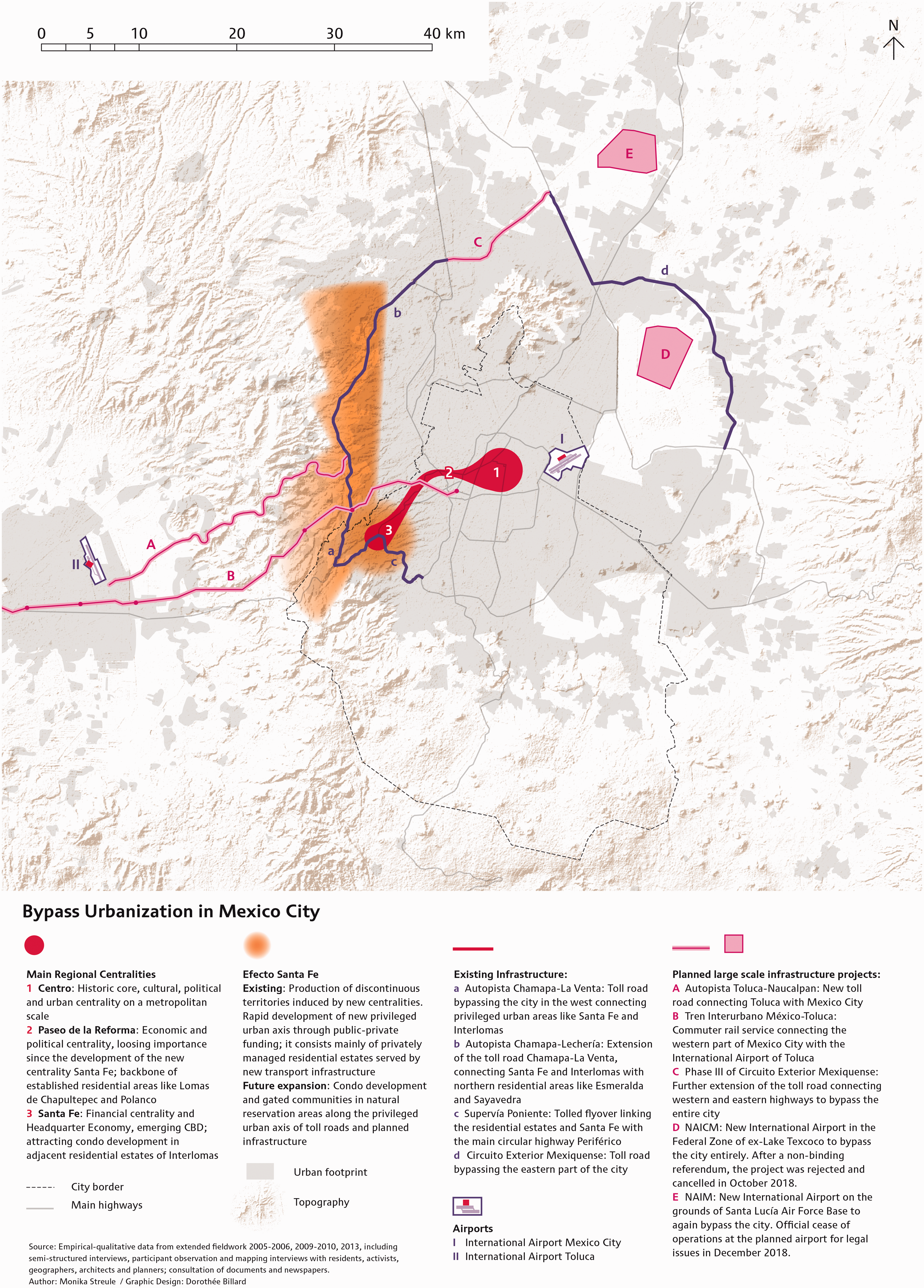
Bypass urbanization in Mexico City in relation to the metropolitan scale (map design by Dorothée Billard, based on Streule, 2018).
The full dimension of this emerging urban configuration becomes discernible through newly built transport infrastructure, such as the toll highway Autopista Chamapa – La Venta (and its prolongation, the Autopista Chamapa – Lechería) leading to the north, one of the most expensive highways in Mexico, 16 and the toll flyover Supervía Poniente, which bypasses the wiggly roads in the western hills for rapid connection to the wealthy southern areas of Mexico City. 17 There are even more projects still in the planning stages, such as the toll road connecting Toluca and Naucalpan or the Mexico City-Toluca commuter rail Tren Interurbano. Toluca, the nearby capital of the State of Mexico, is important to the residents of Santa Fe and Interlomas mainly because of its international airport, which offers a much faster alternative to the Mexico City international airport located in the east of the vast metropolis. Thus, far from creating an isolated enclave, bypass urbanism in Mexico City is profoundly restructuring the entire metropolitan region, resulting in a fundamental sociospatial reorientation towards the western periphery.
All these new infrastructures change the mobility patterns of people who can afford to pay the tolls, while it excludes less wealthy people (Streule, 2018). Thus, the new urban configuration offers affluent people a range of amenities, such as the direct link to the airport, private universities, malls and hospitals, and at the same time allows the avoidance of certain urban threats and nuisances found in more central areas that are located in an earthquake zone and plagued with chronic traffic jams and air pollution (see also Bayón and Saraví, 2013; Ortiz Guitart and Mendoza, 2008). However, even in this privileged area, Mexico City’s different social realities cannot be fully erased and the immediate proximity of wealthy and popular neighbourhoods is still part of everyday life. For residents of the luxury condominiums of Interlomas it is common to ask: “What’s the view from your apartment: San Diego or Tijuana?” 18 Depending on whether they see Santa Fe or the popular neighborhoods of Naucalpan, they indeed could imagine living in two different worlds. Although the imaginary of upper-class white Mexican residents may refer strongly to the image of a ‘first world city’, the area suffers severe infrastructural deficiencies. Urban services are limited and infrastructure problems like water shortages, or erosion of soil walls are common. In 2015, for instance, buildings in a central area of Santa Fe nearly collapsed in a spectacular landslide. And even if such real estate developments are sought after to bypass the existing urban structure, accessibility to established centralities remains crucial for many functions and therefore this kind of bypass urbanism is still connected to the vast majority of Mexico City’s territories (for a broader discussion see Hiernaux Nicolas, 1999; Lindón, 2006; Müller, 2014).
The government of Mexico City launched the large-scale real estate project Santa Fe in 1987, in the wake of Mexico’s dramatic economic crisis and after the major earthquake that destroyed large parts of the central areas of Mexico City in 1985. The project was intended to follow the global trend set by urban megaprojects such as La Défense in Paris and Docklands in London (Moreno-Carranco, 2013). 19 In order to bypass the usual urban planning procedures, the government declared Santa Fe a “special zone of controlled urban development” (Zona Especial de Desarrollo Controlado) ZEDEC Santa Fe. This zone covers around 940 hectares and incorporates land in the two boroughs (alcaldías) of Álvaro Obregón and Cuajimalpa. An urban development project that transcends administrative borders was a novelty at the time and still is extraordinary for Mexico City today. ZEDEC Santa Fe was thus located on administrative ambiguous terrain, establishing a grey zone for planning and administration.
The government assigned a newly founded semi-private company, Servicios Metropolitanos (SERVIMET), to manage the special development zone and gave it the responsibility for constructing the necessary infrastructure, the marketing and the sale of the land. The company was also responsible for the implementation of the master plan and thus de facto for most planning-related tasks. In 2002, due to operational irregularities and various corruption charges, SERVIMET was liquidated. It was replaced by the Fideicomiso Colonos de Santa Fe, a public-private trustee company, which incorporated representatives of both the government and the main private investors, but was fully financed through public funding. Its task was to manage the official public budget for Santa Fe, to plan the infrastructure and to implement safety programs. The government argued that this de facto privatization of the local administration was necessary because the ZEDEC Santa Fe stretches across two boroughs, and therefore the responsibility for the whole zone was not clearly defined. However, after 2010, protests arose and popular neighborhood residents of the same area questioned the unilateral state financing and the exclusive public agenda of the trustee company based largely on self-interests. The protesters thus demanded financial transparency and a re-nationalization of public services. In 2013, the city government finally transferred the public administration back to the two corresponding boroughs.
This privatized layout of institutions was key to successfully bypassing ordinary planning procedures and turning Santa Fe into the first and only privately managed territory in Mexico City (see also Valenzuela, 2007, 2013). The government created new planning mechanisms in order to foster a faster, more flexible and site-specific handling of large building projects (Parnreiter, 2011, 2015). However, manifold contestations and protests arose against this exclusive and segregated urban development, further fueled by state led land expropriations, displacements due to privately developed infrastructure projects and rising land prices (Castañeda, 2014; Pérez Negrete, 2013, 2017). Whereas in the first phase of the construction of Santa Fe residents of popular neighborhoods were evicted and their livelihoods based on the former dumpsite were ruined, today Indigenous villagers forcefully struggle against other effects of this bypass urbanism, such as the privatization and extraction of natural resources like water or land. One example is San Francisco Xochicuautla, an Indigenous village of the Hñähñu-Otomí people north-west of Mexico City, where the attempted expropriation of common land to build the toll road Autopista Toluca–Naucalpan provoked still ongoing strong local resistance (González Reynoso, 2014; Streule, 2019b).
As has become evident, bypass urbanism in Mexico City is not the result of a top down planning process but of converging interests of a variety of influential governmental and private actors, such as federal states, local governments, private national and international investors and developers, particularly transnational real estate groups. 20 Although the state played a key role for initiating bypass urbanism, private investors strongly determined this process not least through their major influence on planning bodies, as shown above. The massive change of territorial regulations mainly to the benefit of private interests unleashed an unprecedented urban dynamic: office towers, apartment blocks and gated communities are becoming predominant not only in Santa Fe and Interlomas, but in a vast area of the western periphery including boroughs of the City of Mexico such as Álvaro Obregón, Cuajimalpa and Magdalena Contreras as well as municipalities in the State of Mexico like Huixquilucan, Naucalpan or Ocoyoacac. Thus, a regional effect of spontaneous speculation has unfolded, that we call “Effecto Santa Fe” (Streule, 2018). Real estate prices in Santa Fe are in US Dollars and the monthly rent is among the highest in Mexico City, exceeding prices in prestigious neighbourhoods in the vicinity of the Paseo de la Reforma like Polanco, Lomas de Chapultepec or Lomas de Tecamachalco. This emerging high-end real estate market is attractive for expats and for very well situated Mexican families, who prefer the safety of a gated community compared to those more central affluent residential areas (see also Angotti, 2013; Roitman and Giglio, 2010; Sheinbaum, 2008).
In the broader perspective, the bypass effect in Mexico City is less marked than in Kolkata and Lagos, mainly because the peripheralization of the historically entrenched centralities is less evident. After decades of neglect and decay, the Centro Histórico, for instance, has recently seen strong urban transformation. There, successive city governments have implemented a multi-faceted program of revitalization, beautification, policing and social cleansing, in partnership with private investors, most notably billionaire Carlos Slim (Hanakata et al., 2020; Streule, 2008). The Centro Histórico has thus regained importance as cultural and political center, yet it is still only a partial centrality and thus not challenging Santa Fe as a financial and commercial center and as a headquarter economy.
Bypass urbanism: Commodification and peripheralization
What are the specific characteristics of bypass urbanism? The analysis of the three case studies allows us to refine our initial definition:
Bypass urbanism implies the material production of a relatively dense, affluent and exclusive urban landscape in a remote sector of the urban region. At the core of the process could be one or several large infrastructure or real estate projects (such as Rajarhat New Town and the Eastern Metropolitan Bypass highway in Kolkata, the financial centrality of Santa Fe in Mexico City or the Lekki-Epe Expressway in Lagos), which are complemented by various additional infrastructure projects (such as toll highways or bridges), and attract business districts, exclusive residential areas, shopping malls, private schools, hospitals etc. Bypass urbanism is thus not arising from the construction of a particular new town or megaproject, but is the result of the simultaneous development of an ensemble of various independent but related projects, which together have the potential to profoundly restructure the entire urban region. This form of urbanism bypasses existing territorial regulations. It does not usually emanate from a coherent planning initiative, even less so from a hidden ‘master plan’ at the hands of any single developer or state agency, but emerges through a convergence of interests over large areas of land at the geographical periphery of urban regions that have strategically been made available for urban development. In most cases, it is put forward by multiple alliances of public and private actors: private corporations and developers acting for profit as well as various state actors making use of private capital to achieve infrastructural and financial gain, additional prestige and political power. Bypass urbanism is also an often-desired form of urban development for emerging middle-classes and globally-versed elite urban populations, fulfilling their demands for housing, more comfortable and prestigious lifestyles, better transportation and investment opportunities. The resulting urban configuration generates a sociospatial separation from existing urban areas and instantiates a socioeconomic segregation at a very large scale. It partially links to the existing urban fabric through newly built transport infrastructure and thus takes advantage of existing centralities, at the same time redirecting investments towards the emerging centralities. Bypass urbanism, as the outcome of a wide range of individual initiatives and decisions thus incorporates a fundamental logic of uneven urban development through the reordering of center-periphery relationships.
In this concluding section, we compare the different experiences collected in the three case studies and discuss specific conditions and outcomes of bypass urbanism, such as the formation of territorial alliances underpinning bypass urbanization and the continuous struggles over land that accompany this process. We then look at the results and consequences of bypass urbanism affecting the entire urban region: the commodification of the urban periphery, the production of new centralities, the process of large-scale peripheralization and changing center-periphery constellations.
Territorial alliances: Bypass urbanism is based on pragmatic but not necessarily coordinated decisions by a variety of public, parastatal and private actors that can also intersect and overlap. The role of the state varies strongly over time and context: state actors are neither the only significant actors, nor are they merely facilitators for private investment. They intervene into bypass urbanism as regulators, landowners, and financiers. They exploit their legislative and administrative powers to intervene into real estate markets and they also acquire and consolidate large areas of land. However, in a situation in which the potential to generate value and to extract profit from urban land has increased dramatically, corporate actors and private finance influence the development of urban space at much larger scales. In Mexico City, the government and private actors were explicitly intertwined, and private interests were incorporated into the planning process through the creation of parastatal agencies and semi-private management bodies. Private actors, including transnational corporations and investors, played a direct role in the management of public funds for urban development, and at the same time developed their own major projects in the area. In Lagos, although the management of urban development remained more clearly in the purview of Lagos State, due to the massive infrastructural deficits and the limitations in state finances, private actors played a significant role in the provision of public infrastructure and the development of prime urban land. While the roles of parastatal and non-state actors were formalized through various acts of legislation across different contexts, negotiable regulatory systems opened up myriad opportunities for exploitation and unplanned development. Powerful traditional landowning families have colluded with the state to maximize the value of their land and became influential actors in the urban development of the Lekki corridor. In Kolkata, the State of West Bengal played a key role in the development of the infrastructure, such as the Eastern Metropolitan Bypass highway and the metro system. It also took the lead in the planning and realization of the new towns of Salt Lake and Rajarhat, and was responsible for acquiring and expropriating the land. Private investors and individual landowners took advantage of these state initiatives and projects in many ways, by exploiting various opportunities for construction, often through illegal practices, such as encroaching into the wetlands or filling up ponds and waterbodies. As these examples show, the roles of state and private actors in bypass urbanism cannot be assumed: in every case specific territorial alliances were forming seeking to take maximal advantage of their power and resources to exploit the urbanization process.
Struggles over land: The acquisition and consolidation of land is a highly contested process in all three urban contexts, because developers and state agencies are often operating in a legal ‘grey space’. In Kolkata, the State of West Bengal took the lead in providing the land for urban development, by expropriation of designated “rural” land for urban development, maintaining and exploiting a “deliberate uncertainty” about land tenure and acquisition (Roy, 2014). In Mexico City, the bypass area extends across municipal and state boundaries, creating uncertainty over jurisdiction and responsibility that is open to manipulation. The government of Mexico City also expropriated land in the initial phases of establishing the special development zone Santa Fe. In Lagos, after a protracted legal battle with traditional landowners, the state government took control of almost the entire Lekki corridor, but left key areas of prime land in the control of some of the powerful landowning families. The resulting increase in land tenure security unleashed the urbanization process and allowed state actors, some traditional landowners as well as private developers to fully exploit the opportunities of bypass urbanism. In Kolkata and Mexico City, there was strong contestation of the expropriation of private and communal land, the skewing of access to centralities, the destruction of livelihoods and ecosystems, and environmental degradation. In Kolkata, various projects have been stalled or even stopped due to popular protests. However, the lack of transparency in the land acquisition process, and the bypassing of formal planning procedures hampered organized resistance. Further, in terms of its “unintentional” impacts on a vast scale and without an overall masterplan, bypass urbanism might slip under the radar of public attention, leading to public unawareness that further inhibits mobilizations.
The commodification of the urban periphery: A key feature of bypass urbanism is the fact that it plays out at the urban periphery and turns large expanses of “non-urban” peripheral land into prime urban land with a much higher market value. This land was originally peripheral in a double sense: it was a) geographically peripheral at the outskirts of urban regions and b) peripheral in socioeconomic terms, because it was relatively sparsely populated land, designated as agricultural land, nature reserves, or land considered unsuited for urbanization, such as wetland, steeply sloped or unstable land, or land that had become dilapidated and contaminated. Bypass urbanism is thus a process that produces new privileged urban spaces out of peripheries: the eastern wetlands in Kolkata, the sparsely populated and flood prone Lekki peninsula in Lagos, and the unstable sand mines filled with contaminated waste in the western hills of Mexico City. In all three cases peripheral land with little value was transformed into “urban” land and thus into a commodity that can be used for urbanization. In this logic, the realization and extraction of the potential rent gap inherent in these lands is a key aspect of bypass urbanism(see also Shatkin, 2017: 214; Smith, 1996).
The production of new centralities: Bypass urbanism goes far beyond the process of commodification of land, though, as it also entails the production of new centralities in these peripheral areas. This process has far-reaching implications and impacts outside the areas directly concerned, because it fundamentally alters the center-periphery constellation of the entire region. Only in a relational understanding of urban space do the full dimensions of this process come to light. In this context, it is useful to recall Lefebvre’s reflections on centrality as a basic condition of the urban. He understands centrality as a key resource, as it condenses the wealth and the potential of an urban society, and creates a situation in which different elements no longer exist separately and separated from one another. Centrality therefore promotes exchange, convergence, gatherings, encounters and meeting (Lefebvre, 2003: 39). In this light, bypass urbanism fundamentally alters the configuration of centralities in an urban region, because it not only has the effect of relocating centralities, thus depriving entire parts of the urban region of this crucial resource, but it also alters the quality of the existing centralities. Bypass urbanism thus means the strategic production of new centralities and an establishment of a reciprocal relationship with existing centralities.
Analyses therefore need not only to focus on the newly built areas, but also take into consideration the effect bypass urbanism has on the wider urban context. In Mexico City we could observe a “Santa Fe effect”, where a large area at the western fringes was upgraded as a result of the development of the financial centrality of Santa Fe and the concomitant construction of toll roads, bridges and tunnels. Bypass urbanism also creates the potential for functions of existing centers to be displaced to the bypass area, such as new government agencies or corporate facilities. In Kolkata, important public institutions and even state functions were relocated to Salt Lake and Rajarhat, while the existing centralities in the inner city are facing disinvestment. In Lagos, the planned industrial developments at the eastern end of the Lekki corridor will displace key functions from existing centers, leading to a massive draw for labor and investment.
Large-scale peripheralization: It is thus the process of peripheralization that is set in motion through bypass urbanization. We use this notion here to highlight the reordering and reconfiguration of sociospatial relations. Sassen (1994) applied it in the context of global city formation, in which the production of new strategic centralities led to a process of devaluation of other economic sectors and hence also of other urban spaces. In the context of bypass urbanism, however, it means a devaluation of entire parts of urban regions. In Lagos and Kolkata, reinvestment into innercity areas is hampered by congestion, density of people, strong socioeconomic inequalities with large poor majorities and multiple claims over land. In Mexico City, the redevelopment of the Centro Histórico was restrained for a long time. Only after policy reforms eliminated rent caps in the early 1990s, massive reinvestments by state and private actors became possible.
This process of peripheralization of central urban areas marks a main distinction to other processes of urban restructuring. Bypass urbanism thus designates a clear difference from the well-known restructuring processes that were conceptualized under terms like “edge city” (Garreau, 1992), “exopolis” (Soja, 2000) or “in-between city” (Sieverts, 2003). While many new centralities emerged in the urban peripheries through these processes, the metropolitan centers were strengthened simultaneously. The result could be seen as “regional urbanization” (Soja, 2000) with a strong tendency towards poly-centrality and densification of the urban peripheries. However, in the process of regional urbanization, the existing hierarchy of centralities persists, and sometimes is even reinforced: while new centralities are emerging in the urban peripheries, they are neither replacing nor bypassing the existing centralities in the urban cores.
Changing center-periphery constellations: The distinction between bypass urbanism and other forms of peripheral urban restructuring can be illustrated by our own comparative research: while in all our eight case studies massive transformations of urban peripheries occurred, only three of them experienced bypass urbanism. This can be illustrated by the case study on Paris in our comparative analysis, where many centralities in the banlieue were planned and realized since the 1960s, including the famous villes nouvelles (new towns) with their newly developed centers, and the spectacular business district La Défense that served as a role model for Santa Fe in Mexico City. However, these peripheral centers did not become an alternative to the main central area of Paris, which developed into an even more attractive and privileged urban space in the meantime (Wong et al., 2020). A different constellation developed in Los Angeles with its entrenched polycentric urban structure, also a case study in our project. While Downtown L.A. struggled over decades to become a major centrality, countless new centralities emerged scattered across the extended urban region. In the last decade, however, Downtown L.A. was turned into a renewed and refurbished centrality, attracting new businesses and affluent middle-class populations in the search of urbanity (Hanakata et al., 2020)
These observations based on our own comparative research illustrate the wide range of different possible center-periphery constellations and highlight one crucial aspect of bypass urbanization: it goes hand in hand with the peripheralization of extant centralities. Thus, with bypass urbanism a new kind of disparity appears, which leads to an inversion of the center-periphery relationship. In this decisive respect, bypass urbanism represents an opposite development to current trends in most large metropolitan regions across the world where central areas are upgraded through flagship projects, urban regeneration strategies and large-scale redevelopment efforts, intensifying gentrification and socioeconomic upgrading of entire innercity areas. With bypass urbanism, however, it is the geographical periphery that is made into a privileged space, avoiding the messiness of existing urban situations, their complex urban structures, entangled land regulations and endless negotiating processes with its various stakeholders. Thus, the former edge becomes the center with a reciprocal and privileged relationship to existing centralities.
Bypass urbanism is thus leading to a fundamental structural transformation of urban regions on an unprecedented scale. The production of huge exclusive territories with privileged access to efficient infrastructure and various urban functions and amenities is intensifying existing inequalities, strengthening sociospatial segregation and reconfiguring center-periphery constellations. These tendencies are often difficult to discern; the excentric perspective of planetary urbanization allowed us to grasp this specific urbanization process and to contextualize various urban projects in the context of the entire region. The main goal for the introduction of the concept of bypass urbanism is to highlight and create awareness of this regional scale of urbanizationthat is occurring in and beyond the three cities presented here, and that adds an additional layer to the wide range of important contributions on megaprojects and new towns. Further, this awareness might enable more critical interventions in the process that respond to the large scale of the process, and might make isolated local struggles more visible to one another.
Footnotes
Acknowledgements
This article is a result of the collaborative research project Patterns and Pathways of Planetary Urbanization conducted at the ETH Future Cities Laboratory Singapore (FCL) and the Chair of Sociology, Department of Architecture at ETH Zürich. We thank all our colleagues from the Future Cities Laboratory for their support, advice and inspiration. We express our special thanks to the project team members Naomi Hanakata, Pascal Kallenberger, Ozan Karaman, Anne Kockelkorn, Kit Ping Wong and Rob Sullivan who contributed substantially to the development of the concepts of urbanization presented here. We would like to thank the two anonymous referees for their careful reading and constructive suggestions. For the design and production of the three maps, we thank Dorothée Billard, Roger Conscience, Philippe Rekacewicz, as well as Tobias Kugler and Daniel Zielinski. Furthermore, we would like to thank Jennifer Robinson for her careful reading of the text. Last but not least, we are grateful to all researchers and urbanists from Kolkata, Lagos and Mexico City who kindly participated in our mapping workshops and generously shared their knowledge in the earlier stages of the project. All errors and omissions remain our responsibility.
Declaration of conflicting interests
The author(s) declared no potential conflicts of interest with respect to the research, authorship, and/or publication of this article.
Funding
The author(s) received no financial support for the research, authorship, and/or publication of this article.