
Abstract
The related concepts of 15‐minute city and 20‐minute neighbourhood have gained increased attention, contributing to planning and transport strategies and policies in many cities with the objectives of reducing car use, boosting local economies, improving liveability of places and the health of those who live there. However, there has been relatively little consideration of whether and how the 15/20‐minute place concept can be applied beyond world cities to the towns and suburbs where many people live. Taking the example of Wales, the paper develops empirical analysis to explore the nature of and variation in car-dependence in a range of different places, from densely populated city centres to residential suburbs and small towns. This analysis shows that the potential for developing more liveable, less car-dependent places exists not only in central cities but in some smaller places where there is a resident live-work population and relatively short commuting distances. For places like Wales, which has already incorporated the 15/20‐minute place ideal into its planning framework and transport strategy, the aspiration to reduce car dependency will require policies that reflect the very different starting points in Welsh places.
Keywords
Introduction
The 20th century view of habitation as inevitably intertwined with the car has been challenged at the turn of 21st century by the cognate concepts of 15‐minute city and 20‐minute neighbourhoods (Capasso Da Silva et al., 2019; Moreno, 2019; Moreno et al., 2021). These are redefining the imaginary of modern life around local living, active travel – walking, wheeling and cycling – and public transport. The 15/20‐minute place concept has articulated and reinvigorated established planning ideas around ‘human scale’ (Gehl, 2006), ‘compact urbanism’ (Jenks et al., 1996), ‘proximity’ (Silva et al., 2023), the ‘neighbourhood unit’ (Kissfazekas, 2022) and territorial/spatial justice (Boyne and Powell, 1991) into a transformative vision of a different urban future, where opportunities and amenities are more accessible and environmental impact is meaningfully reduced. This has the potential to change the character of local economies, with significant implications for planning and the local delivery of public services.
Embraced and promoted by world capitals such as Portland (Portland, 2012), Melbourne (Victoria Department of Transport and Planning, 2023) and Paris (Hidalgo, 2020), this broad vision has galvanised mayors and practitioners, as well as providing an accessible label for actions that some cities were already taking (see, e.g., Barcelona City Council, nd). But if the objectives encapsulated in the 15/20‐minute vision are laudable in relation to social and environmental crises, can they be socially transformative through extension of the concept beyond a few, high-density cities? In particular, to what extent is it feasible to significantly increase active travel journeys by reducing car use in countries like the UK? In the context of the car-dependence of high-income countries, is the idea of large-scale modal shift away from car use fantasy or part of the solution to the sustainability and liveability puzzles?
Questions have also been raised about the wider applicability of the concept in relation to the design of neighbourhoods. For example, the UK Royal Town Planning Institute notes that: implementation [of the 20 minute neighbourhood] is likely to be easier in settlements that pre-date the 20th century, which were created in an era when most journeys were made on foot and development was compact - and yet just 20% of homes in Britain today were built before 1919. If 15 minute cities are to be equitably implemented, we need to understand how to apply the concept to existing 20th century neighbourhoods (Royal Town Planning Institute, nd).
Taking a cue from such considerations, this study explores the possibilities and challenges of reducing car use outside major metropolitan area, with the aim of understanding the possibilities of a major modal shift in less densely populated places. To do so, the paper focuses on Wales, a small country where most of the population lives outside large dense cities. The research takes a meso-perspective (Boussauw et al., 2023) on car-dependence, considering mobility patterns in relation to the settlement structure of different Welsh places.
In Wales, there has been a shift in policy thinking towards encouraging more active travel since 2013 (Senedd Research, 2023). More recently, reducing car use has become an explicit goal (Welsh Government, 2021a), with a target of increasing the proportion of journeys by public transport or active travel from 32% to 45% by 2040 (p. 48). Such high level statements are inevitably spatially blind, abstracting from the diversity of places and their specific opportunities and challenges. In looking at how this target could be met, the Centre for Cities think tank has argued that it is only in the capital, Cardiff, where significant modal shift from car use to public transport can be achieved (Coombes and Rodrigues, 2023). Even in the three other (relatively) major cities, population size and densities make the economics of public transport challenging.
As will be argued in this paper, mobility patterns vary substantially across Wales – not only between but also within places. This has important policy implications for shaping the nature and extent of a desired modal shift in travel. The implication is that a spatially sensitive strategy to reducing car use will need to reflect the specificities of different places across urban, peri-urban and rural areas, including the extent to which ‘live-work’ places already exist.
The increased interest in the idea of 15/20‐minute places by authorities at national, regional and local level make this an important issue, relevant to many areas of decision making including development planning, transport, health and leisure. It is also connects to issues of social justice given the inequalities that have resulted from increased car-dependence when a significant minority have no access to a car. If there is already some agreement about the potential benefits of proximity to amenities, this implies the need to explore whether and how those benefits could be realised outside of major cities, in the places where the majority of the population in countries like Wales live.
The paper is organised as follows. In the next section we explore the concept of the 15/20‐minute place in the context of the literature on car dependency and the notion of metrophilia. Following this, we introduce the exploratory research design, the choice of cases, variables and data sources. The fourth section analyses the mobility patterns of different Welsh places – from small towns to central districts of the major urban areas – considering settlement structures, mobilities and the wider territorial context. The fifth section discusses these findings, the relevance for developing 15/20‐minute places in Wales and the implications for policy, before a conclusion in the final section.
The 15/20‐minute place in the context of car-dependence: Socially transformative vision or metrophilia?
The cornerstone of the 15/20‐minute place concept is of polycentric and compact settlements where neighbourhoods contain the amenities essential for liveability so that living, working and socialising can be accessed by active travel (Capasso Da Silva et al., 2019; Moreno et al., 2021). Public transport allows longer journeys to reach specialised services, such as a large hospital serving multiple neighbourhoods, while the car is relegated to occasional use. This form of spatial organisation is seen as creating more equal places – with amenities more evenly distributed and accessible – while reducing environmental impact as car use is reduced.
Against the background of social and environmental crises, in the UK the concept of the 15/20‐minute place has gained some traction as a socially transformative vision of spatial development. Cities such as Oxford (Oxford City Council, nd), Bristol (Bristol City Council, nd), Sheffield (Sheffield City Council, 2022) and Birmingham (Birmingham City Council, 2021) are exploring and/or developing plans that incorporate the principles of 15/20‐minute city/neighbourhoods, or simply ‘liveable neighbourhoods’. In Scotland, 20‐minute neighbourhoods have been included within the Programme for Government 2020–21 and explicitly mentioned in the National Planning Framework 4 Position Statement’ (RTPI Scotland, 2021). Even universities have started to think about their campuses as a 15‐minute place (Barratt and Swetnam, 2022).
In Wales, in the context of the of the Wellbeing of Future Generations Act, the ‘20-minute neighbourhood’ concept has been recognised in the latest version of the National Development Framework where the stated aim is, ‘building sustainable places that support active and healthy lives, with urban neighbourhoods that are compact and walkable’ (Welsh Government, 2021b: p. 65). It has also been explicitly incorporated into the Welsh Transport Strategy, which has the ambition of ‘bringing services closer to people’ while achieving a ‘modal shift’ where the ‘proportion of trips made by sustainable modes increases and fewer trips are made by private cars’ (Welsh Government, 2021a: p. 48).
If the notion of the 15/20‐minute place is animating policy hopes for a more sustainable future, its large-scale deliverability is far more complex. Experiments with 15‐minute approaches in the UK and elsewhere have encountered popular resistance in some cities; even if this is based on misunderstandings (Silva, 2023), it can undermine political commitment even to the idea of reducing car dependency. As Hewett and Koksal (2023) note, the ‘constructive ambiguity’ of the concept adds to its attractiveness but creates practical problems about exactly which amenities should be included and how/how easily they should be accessed. More significant for the purposes of this paper, however, is the issue of its applicability beyond dense urban neighbourhoods to lower density, peri-urban and suburban places, because of the extent and embeddedness of car dependency (Urry, 20024; Newman and Kenworthy, 2013). In effect, there is a hardwired reliance on cars that reflects the interplay of urban planning, mobility infrastructures, distributed employment sites and cultural norms.
Following Boussauw et al. (2023) and Mattioli et al. (2016), the problem of car-dependence can be approached at different scales. The micro scale considers this as an individual problem of cultural orientations and capacities; while the meso-scale conceives car-dependence as an attribute of place, where the built environment, transport infrastructures and zoning together create a situation where the car is the most convenient – if not the only – way to reconcile living and working. In contrast, the macro perspective sees car-dependency as a wider societal or political-economic problem.
The macro perspective offers little prospect for the large-scale application of the 15/20‐minute place vision, as the system of automobility in Europe appears entrenched. At the turn of the century, car use had seemed to level off in many European countries – and even to show some decline in a few cases, notably Sweden, United Kingdom, Netherlands, Luxembourg and Italy (Focas and Christidis, 2017). This prompted a debate about the possibility of reaching ‘market saturation’, ‘interrupted growth’; or indeed suggested an early sign of ‘peak car’, a ‘long-term decline in car use due to a complex combination of drivers in which economic influences are modified by policy, attitudinal, social, technological and cultural changes’(Focas and Christidis, 2017: p. 535). However, recent trends in car use have ruled out the peak car thesis. In the UK since 2015, car ownership has started to rise again (Department for Transport, 2023) while across Europe the average motorisation rate increased from 501 to 563 vehicles for every 1000 inhabitants between 2013 and 2022 (Eurostat, 2023a). Country-specific trends show consistent increases in motorisation rates across all EU member-countries between 2001 and 2021 (Eurostat, 2023b).
At the micro scale, research attention has focused particularly on millennials, who have lower car use and ownership rates compared to previous generations, which some have interpreted as an emerging cultural shift in preference towards active travel and public transport. However, empirical research shows that on an aggregate level the lower car use of this generation is related to conjunctural economic and social factors – such as income stagnation or delayed entrance into the labour market – with limited evidence of a cultural change (Venu et al., 2016). Indeed as millennials grow older they tend to adhere to the cultural patterns of high car use of previous generations.
If achieving the 15/20‐minute place vision outside dense cities looks unlikely from these micro and macro perspectives on car-dependence, the meso-perspective offers more hope as place-based studies show that substantial modal shifts can be achieved at the local level. Despite some scepticism (Gomez-Ibanez, 1991; Saedizand et al., 2022), a large and diverse body of research over the past three decades has shown that the structure of settlements is a key variable influencing travel behaviours (see, e.g. Buehler et al., 2016; Camagni et al., 2002; Lee et al., 2017). In particular, dense and mixed-used settlements are a structural precondition for reducing car-dependence and promoting active travel and public transport. For example, European cites which have consistently promoted the development of compact settlements, along with active travel and public transport infrastructures, have been able to achieve substantial modal shifts. Dutch and Scandinavian cases are perhaps most well-known (Buehler and Pucher, 2021; Gössling, 2013), but car use reduction in major cities has also been observed in Germany, Austria and Switzerland (Langeland, 2015). The German case is of particular interest because, although car ownership in Germany is much higher than in the UK, the proportion of journeys made by bicycle is almost 10 times greater (Pucher and Buehler, 2008).
However, studies focused on the meso-perspective on car-dependence also highlight that substantial modal shifts have been limited to cities (or at least such studies have only been conducted in cities). This insight seems consistent with Pozoukidou and Chatziyiannaki’s (2021) argument that the 15-minute neighbourhood is not a ‘fit for all-idea’ but requires ‘a mix of physical and non-physical attributes based on the unique urban and social form… of each city’. Indeed, recent studies on cities that have been discussing the adoption of 15-minute place policies, including Barcelona (Ferrer-Ortiz, 2022), Milan (Abdelfattah et al., 2022), London (Jain and Bhatnagar, 2022) and Utrecht (Knap et al., 2023), show that these already have the spatial preconditions of high density, mixed-use and developed public transport; indeed, many of their neighbourhoods already operated as such before 15-minute policies were enacted.
The finding from the literature review that so far a modal shift away from car use has only been demonstrated in dense cities poses a major challenge to the large-scale adoption of the 15/20‐minute place agenda. Most Europeans do not live in dense cities but in rural areas, towns and suburbs. According to Eurostat in 2021, only 39% of Europeans lived in cities, defined as high-density (at least 1500 residents per square km) settlements with at least 50,000 inhabitants. In contrast, 25% lived in rural areas and another 36% in places of intermediate density classified as towns and suburbs (Eurostat, 2022), which are highly car dependent and where enacting a modal shift is inherently difficult (European Environment Agency, 2006).
Given the formal recognition of the 15/20‐minute place in Wales as elsewhere, the question arises: is the 15/20‐minute concept a transformative vision with the potential for large-scale application, or is applicability limited to dense urban areas. The latter would imply that the current enthusiasm for liveable neighbourhoods is a case of what Waite and Morgan (2019) have termed ‘metrophilia’, that is ‘an uncritical embrace of city-centric spatial policy paradigms’ (p. 383). The notion of metrophilia is relevant to the interest in 15/20‐minute places in Wales because it highlights both the aspiration to adopt progressive ideas but also a failure to recognise the structural problems that would need to be addressed to realise their aims.
Methodology
The aim of this paper is to explore the possibilities and challenges of realising the transformative modal shift encapsulated in the 15/20‐minute place vision, using Wales as an example. It takes the meso-perspective on car-dependence outlined in the previous section, focusing on the relation between settlement type and structure and mobility (Boussauw et al., 2023; Newman and Kenworthy, 1989). The key research questions are as follows: How are the settlements structures of different places in Wales related to everyday mobility patterns? How do these settlement structures define possibilities and difficulties for reducing car use? To what extent are there the preconditions for a substantial decrease in car use? Given the current policy interest in the 15/20‐minute, we present an exploratory study that considers key territorial and social structures, and contributes to an understanding of strategic possibilities and challenges around reducing car use.
The study focuses on Wales, a nation in the UK with 3.1 million inhabitants and a diverse territory comprising urban, peri-urban and rural areas and a mix of larger and smaller settlements. As such Wales provides a case study with broader implications for the many territorially mixed regions across Europe. The territorial diversity of Wales is downplayed in the official categories of the UK’s Census, which simply classifies 67% of population as ‘urban’ but does not recognise that this includes a significant amount of peri-urban areas with intermediate density (Bibby and Brindley, 2017). This does emerge, however, from a review of the size distribution of Welsh settlements shown in Figure 1. The distribution of the built-up area population in Wales for towns above 11,000 population, 2011.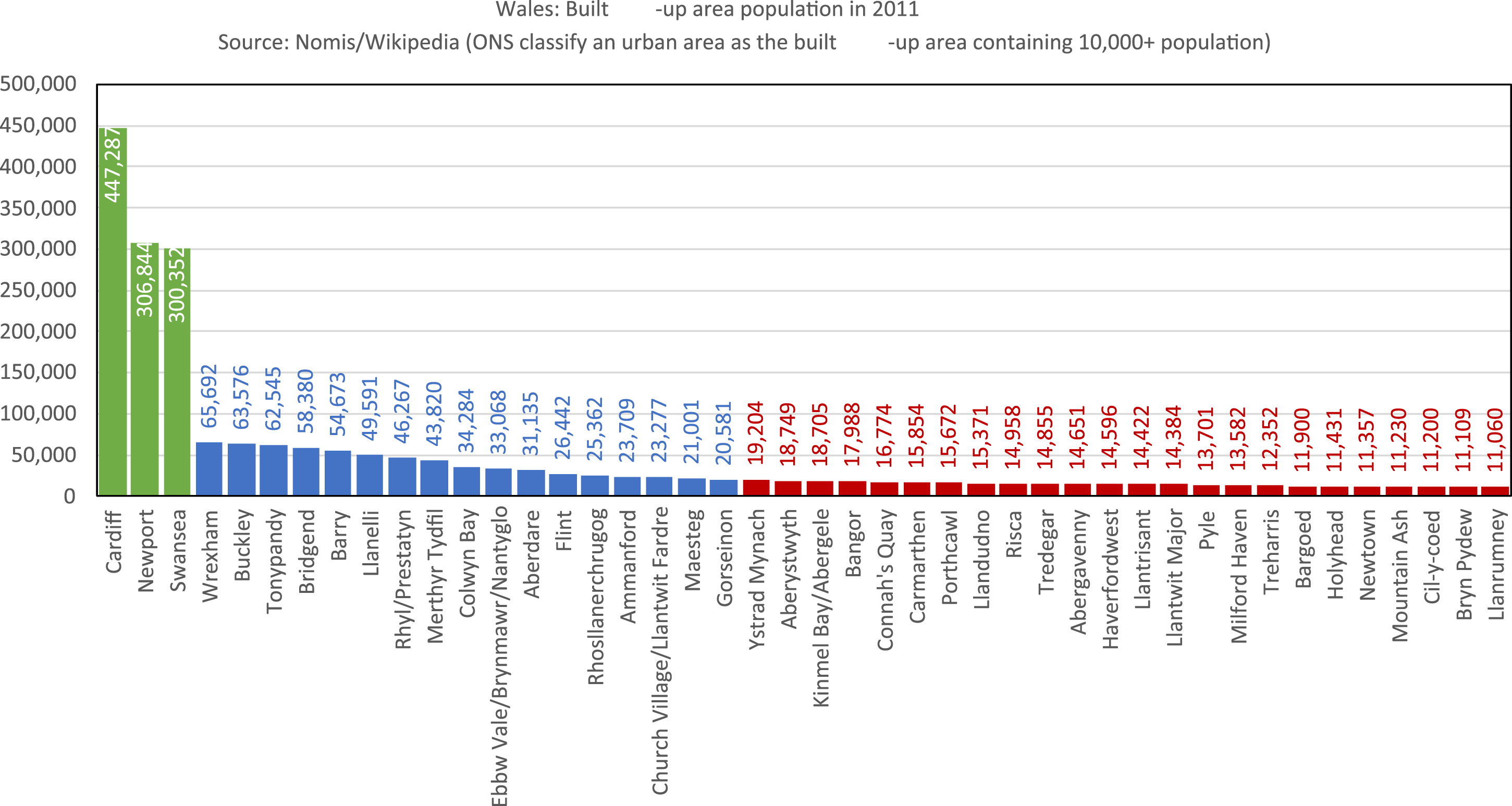
Wales has three mid-sized cities with built-up area of over 300,000 inhabitants: Cardiff, Swansea and Newport. These are located in an urban corridor in the south of the country along the coast. There is then a significant step down to a group of much smaller cities and larger towns, each with between 65,000 and 20,000 inhabitants, like Bridgend or Llanelli in the south or Wrexham and Buckley in the north. These ‘in-between’ cities and towns (Sieverts, 2004) are mostly located in peri-urban territories and make up another 20% of the total Welsh population. However, the largest share of Welsh population (46%) lives in the small towns below 20,000 inhabitants that punctuate the mostly rural Welsh hinterland in the hilly west, centre and north of the country.
Given this pattern of settlement size in Wales, the paper will investigate two key aspects – settlement structure and everyday mobility – to understand the potential for a shift towards active travel, in line with the 15/20-minute place idea. Terms like settlement structure (Brunotte, 2002), urban form (Kropf, 2009), and built environment (Lee et al., 2017) are broadly used as synonyms in urban and regional studies to describe structures of human habitation, with reference to features such as density of buildings and/or population, mix of land uses, design of streets, buildings and public spaces, and transport infrastructures (Kropf, 2009). We use the term settlement structure because it explicitly reflects both the physical buildings and structures and their functional uses, while recognising a range of settlements from the dense urban to the more suburban. To operationalise the idea of settlement structure we use two variables: density and functional mix. Population density is measured using 2021 Census data, while the functional mix has been assessed via fieldwork observation and analysis of online maps, to explore the extent to which places for living, working and shopping overlap.
‘Everyday mobility’ refers to journeys made for shopping, leisure, care, work, education and health, though these can be hard to separate out using existing data. Mobile phone data can provide information on visits to all kinds of different places, such as a shopping centre or hospital. However, this is proprietary data which is not available on open access. The National Travel Survey (Department for Transport, 2023) provides comprehensive data on different kinds of trips on a yearly basis, but this data does not allow the small area analysis that would be relevant to a 15/20-minute place.
For pragmatic reasons then, the empirical analysis focuses on travel to work journeys because this data is available for small areas or districts within a larger town or city. This is not as limiting as it may initially appear because, while travel to work is only the second most common purpose for trips in the UK (Department for Transport, 2023) these trips have a structuring quality. As the literature on ‘trip chaining’ (Primerano et al., 2008) has showed, everyday movements are not atomised, independent practices but structured within a system of movement where some trips depend on others. For example, a ‘mandatory trip’ (Primerano et al., 2008), like travel to work, may then determine which supermarket is visited. Schneider et al. (2022, p. 856) note that ‘research has shown that work seems to be the activity type that stably structures tours in time and space’. Therefore, in the absence of comprehensive data on all kinds of everyday trips, travel to work provides a good working proxy to understand patterns/structures of everyday movements. Moreover, work is one of the six functions that Moreno (2019) included in his explanation of the 15-minute city.
As settlement structures can vary between the same city and town, the unit of analysis is the ‘small area’: specific neighbourhoods, or districts in the case of cities and larger towns; or stand-alone towns in the case of smaller settlements below 20,000 inhabitants. These small areas were approximated using MSOAs (middle super output area) data for neighbourhoods and districts, while for stand-alone small towns the built-up area was used. Small areas differ in size, depending on the density of housing, but in a city district they would be walkable within 15/20 minute and for a less dense small town, the outer to central area would fall within the 15/20 minute walking range. The small areas were selected to reflect a variety of settlement structures in different ‘spatial contexts’ (Wiersma et al., 2016); this is because small areas are functionally integrated into and interact with larger ones. This larger spatial context has been approximated as the county or local authority to which the settlements belong.
The small areas selected for analysis of settlement structure and mobility.
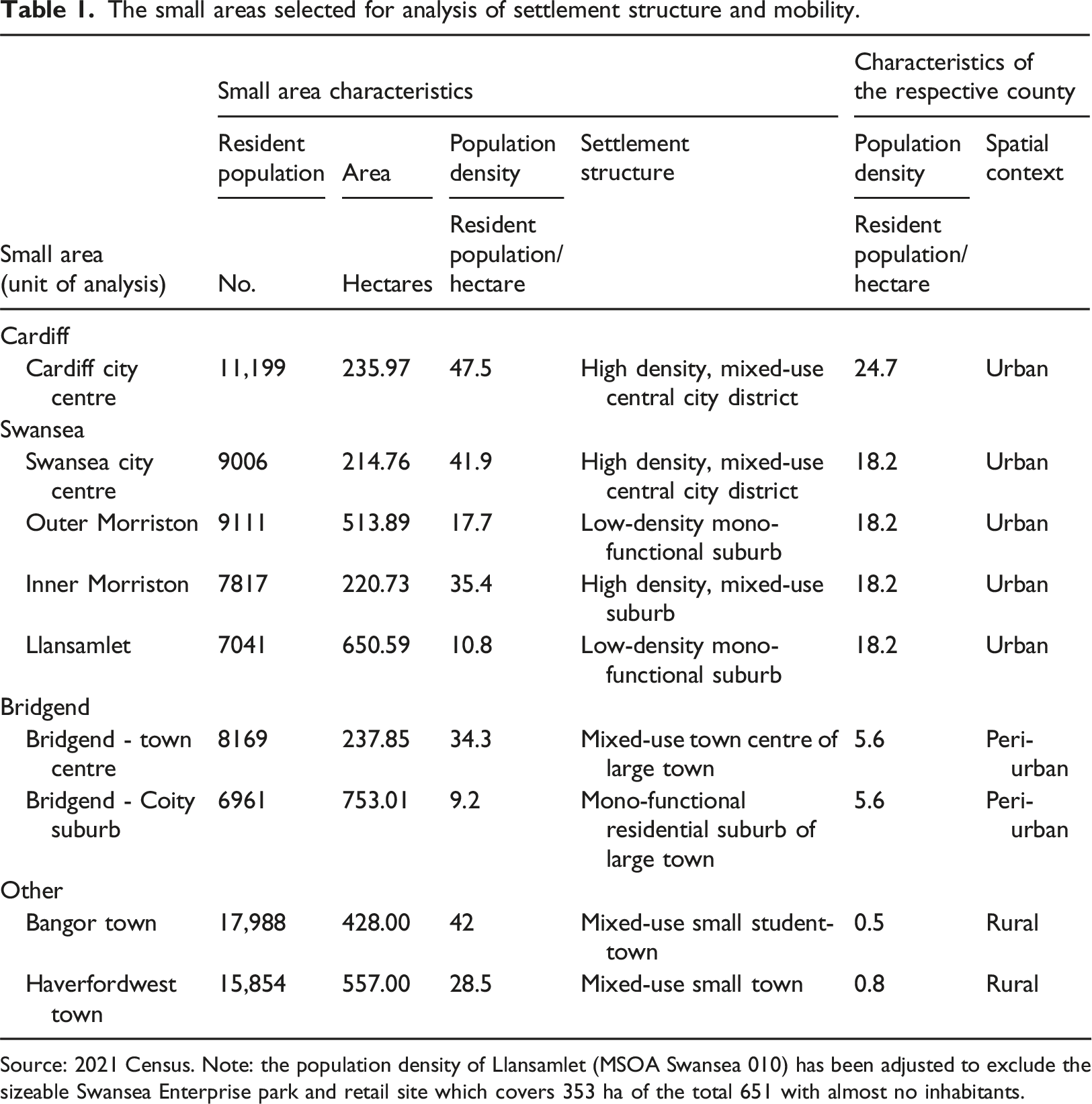
Source: 2021 Census. Note: the population density of Llansamlet (MSOA Swansea 010) has been adjusted to exclude the sizeable Swansea Enterprise park and retail site which covers 353 ha of the total 651 with almost no inhabitants.
The obvious source of data on mobilities for each of these small areas would have been the 2021 Census, but this took place during a national lockdown where the ‘government advice at the time was for people to work from home (if they can) and avoid public transport’ (ONS, 2022). As a result, this introduced a strong conjunctural bias in the 2021 Census with respect to travel to work, with an estimated 5.6 million UK inhabitants on furlough during the census period and major changes in transport behaviour as a consequence.
As a response to this data problem, the ONS is working out alternative, more up-to-date travel to work statistics, but these were not published at the time of writing. The ONS notes that in the 2021 Census travel to work data, it is ‘difficult to know whether patterns detected are concentrations of a) furloughed populations b) pandemic-related changes in behaviour and c) longer-term trends’ and advise ‘extra care’ in interpreting the data for any areas smaller than ‘region’ (ONS, 2022). As our analysis requires reliable data at the neighbourhood level, the 2011 Census data is used. Although it is not very recent, it is certainly still informative as 2011 data reflects the outcomes of consolidated long-term trends over several decades and there are unlikely to have been major structural changes in these small areas that will affect mobility patterns.
Analysis
Most Welsh towns and city centres predate widespread car use and were built for active travel and public transport. Over the past century they have partially maintained these characteristics, with a relatively high density of buildings and residents and a mix of live, work, shop and leisure functions. They are typically the hub of public transports networks and have pedestrianised areas in and around the main high streets, squares and shopping areas. As such they already to some degree possess a 15/20-minute place infrastructure and partially function on that basis. In this section we will explore the two aspects outlined above – settlement structure and everyday mobility – in relation to the nine small areas in Table 1. The analysis of travel to work journeys addresses our first question: how are settlement structures of different places related to everyday mobility patterns. This analysis then leads into the second and third questions: how do these different settlement types define the possibilities and challenges for reducing car use, in line with Welsh Government targets; and to what extent are there preconditions for a major shift towards 15/20-minute places through car use reduction.
Methods of travel to work in Cardiff city centre (MSOA Cardiff 032), 2011.
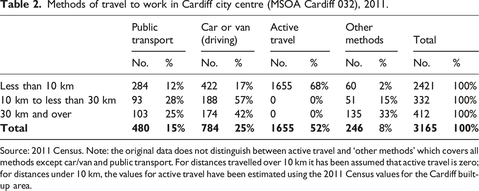
Source: 2011 Census. Note: the original data does not distinguish between active travel and ‘other methods’ which covers all methods except car/van and public transport. For distances travelled over 10 km it has been assumed that active travel is zero; for distances under 10 km, the values for active travel have been estimated using the 2011 Census values for the Cardiff built-up area.
Similarly, in Swansea city centre, there are the partial preconditions for 15/20-minute living. Swansea city centre has a comparable mix of work, live and shop functions to Cardiff although it has a lower density of 35 people per hectare. Its greater urban area is also less dense compared to Cardiff with approximately 18 people per hectare. Nonetheless, Swansea city centre is a mixed-used central urban district and part of a relatively high-density urban area which should make 15/20-minute living possible for many residents. In practice, there is quite a difference between Cardiff and Swansea centres in the extent of car use. In 2011, 37% of residents used active travel to get to work and 11% used public transport; but 50% used a car to travel to work, suggesting that Swansea centre has been partially remade around everyday car use for residents, and to a greater extent than in Cardiff.
While there are signs of 15/20-minute living in both city centres, central Cardiff and Swansea are by no means representative of their larger urban areas. As we move to the edge of these cities, we see settlements increasingly organised for the car with spatial divisions between work-live-spend functions, an overall low density of settlements and road infrastructures that make active travel to work, shop, play and socialise difficult and often dangerous. In Swansea we can see that car use for travel to work is already important in the centre and becomes practically inescapable at the edge of the urban area.
Figure 2 shows the proportion of journeys to work by private car, public transport and active travel in the greater Swansea area. The 50% car-dependence for travel to work journeys in central Swansea contrasts markedly with outer areas where car-dependence is generally at least 75% and often closer to 90% (Figure 2). Llansamlet, a mid/low-income suburb in the northern edge of Swansea built after the 1990s, is a good example of a suburb designed for car use. Llansamlet has a population of 7,000, the size of many Welsh smaller towns. However, unlike small towns – or central urban districts – the area is organised in large monofunctional zones. On one side a large low-density residential area of single family homes with population density of 10.8 residents per capita, almost three times lower than in the city centre or in small towns like Haverfordwest or Bangor. On the other side of the suburb is the Swansea business district, the largest retail and employment hub in the urban area of greater Swansea. Llansamlet has a train station at one edge of the settlement and a few buses that connect with the city centre but with a long ride of 30–45 minute, but there is no quick public transport link from the residential side of the suburb to the business and retail district, which reinforces car-dependence. Share of travel to work by car by medium super output areas (MSOA) in the Swansea local authority area, 2011. Source: The spatial data – the MSOA 2011 boundaries and the local authority boundaries – have been accessed via https://datamap.gov.wales_[datamap.gov.wales]. Car use data is from the 2011 Census accessed via Nomis.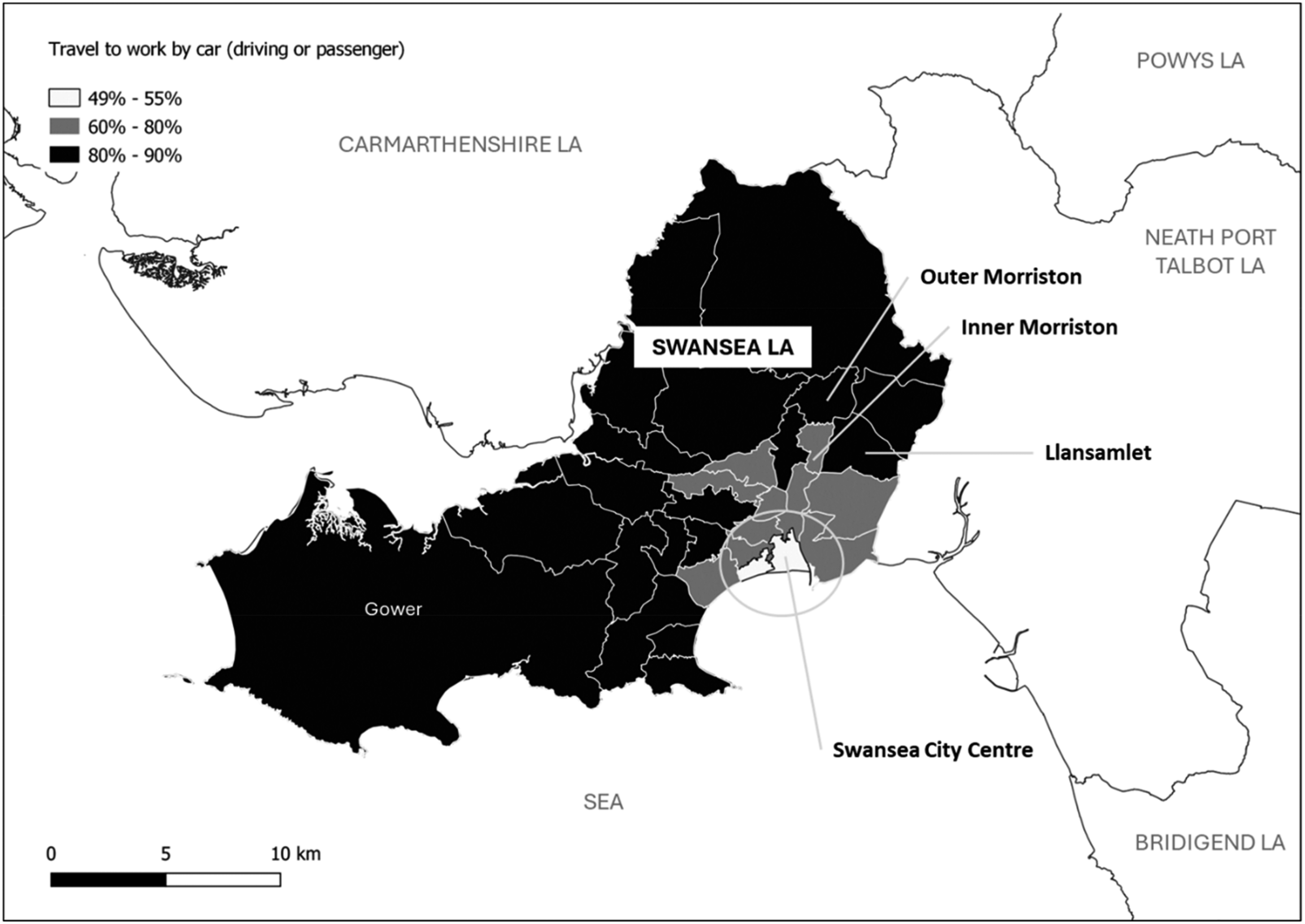
Methods of travel to work in selected areas of Swansea, 2011.
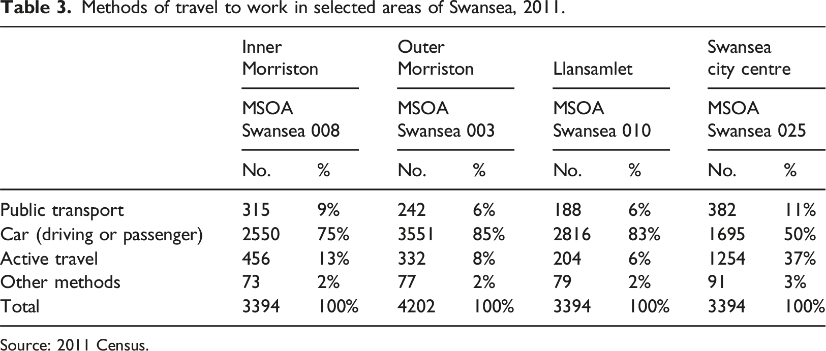
Source: 2011 Census.
The dominance of the car for mobility in the edge of Swansea’s urban area is evident even in the peripheral centres that have a partial 15/20-minute neighbourhood infrastructure. A striking example is Morriston at the northern edge of the Swansea built-up area. Morriston grew historically as a self-contained settlement and its legacy is a dense, mixed, urban infrastructure. The old town – which we have called inner Morriston – has a relatively high density of 35 residents per hectare. At the heart of the settlement is a long high street with shops and services, and homes adjacent. There is a regular bus service along the high street connecting Morriston to Swansea city centre, about three miles in one direction, and Morriston Hospital, about two miles in the other.
In terms of travel to work in 2011, there are signs of a more urban, localised lifestyle in inner Morriston, with 13% of residents using active travel. This is twice as high as in the adjacent outer Morriston suburb, which was designed for car access and has only 6% of residents commuting by active travel. Similarly, the inner Morriston area has greater use of the bus for travel to work at 9%, compared with both outer Morriston and Llansamlet (6%), where bus services is more limited and less accessible (Table 3). However, the overwhelming majority (75%) of Morriston residents commute to work by car, only slightly less than in the outer suburbs at 85%.
If car use is central to mobility in urban areas beyond city centres, a similar picture emerges in towns big and small in rural and peri-urban areas. Bangor in the north-west of Wales, Bridgend in the south-east and Haverfordwest in the south-west are the administrative and/or economic centres of large counties. The three towns are relatively compact and high density. The entire towns of Haverfordwest or Bangor occupy a smaller area then the urban suburbs of outer Morriston or Llansamlet in Swansea. Haverfordwest has an average density of 32 residents per hectare (the same density as the urban mixed-use neighbourhood of inner Morriston) while Bangor, which has a university with student accommodation, has an even higher average density of 42 residents per hectare. Bridgend combines a middling town centre density of 34 per hectare in the core and a much lower level in the outer areas, such as the suburb of Coity with a density of only 9.2 per hectare.
Methods of travel to work in selected areas, 2011.
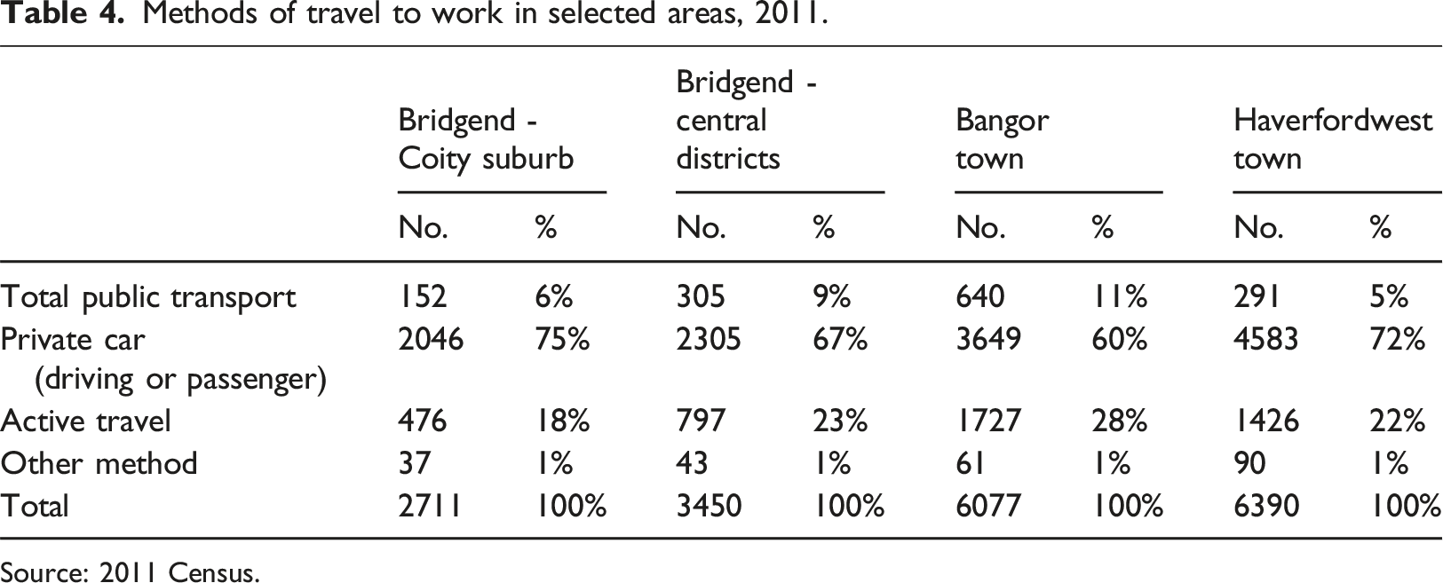
Source: 2011 Census.
Resident workers and commuting movements in and out of the built-up areas of Bangor, Bridgend and Haverfordwest in 2011.
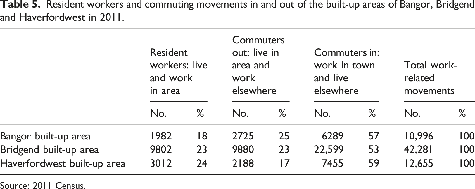
Source: 2011 Census.
Secondly, however, between 18 and 24% of movements were within the area and thus suggests a small base for the further development of a 15/20-minute place. While it is not clear which of the journeys in Table 5 are by active travel, looking at the county-level data it is interesting that active travel is more significant than public transport with 10% of Bridgend County journeys by active travel, rising to 14% in Pembrokeshire and 17% in Gwynedd. This suggests that there is indeed scope for 15/20-minute living in Welsh towns for the significant minority of those living and working in the same town.
Discussion
The concept of the 15/20-minute place is a compelling one, offering not only contributions to ‘social cohesion and interaction’ and a ‘sustainable eco-system in cities’, but also an ‘economic boost’ resulting from residents spending more time in and travelling through their neighbourhoods (Moreno et al., 2021). As noted earlier, the concept is informing the development of transport and related national policies in Wales, with the Future Generations Commissioner identifying this as consistent with the aims of the Wellbeing of Future Generations Act. Moreover, below the national level, the concept is also cited by local authorities including Bridgend (Gavaghan, 2023) and Cardiff (Cardiff City Council, nd) in the development of urban plans, suggesting its resonance in aspirations to address car-dependence and the environmental and social problems that result.
The COVID-19 pandemic spurred new interest in the notion that neighbourhoods should be liveable. The immediate impact of lockdowns – and the legacy effects – on working patterns show a sustained increase in remote working. In 2019, around 5% of GB workers worked only or mainly at home; this rose to over 35% in spring 2020 with lockdowns and remained at around 25% by 2022 (De Fraja et al., 2022). This shift in working brings a redistribution of an estimated £3bn spending on hospitality and retail away from employment sites like central cities to a multitude of smaller places where workers live (De Fraja et al., 2022). Significantly, the Welsh Government has set a target of 30% of the workforce to work at or near home by 2026, citing environmental, social, economic and cultural benefits from this shift (Welsh Government, 2022). Realising this would make a significant contribution to reducing car use, while also increasing demand for neighbourhood amenities.
However, if there is a convergence of interest in the potential benefits of moving towards 15/20-minute places, the analysis presented in the previous section illustrates the very challenging starting point for policy ambitions, given the embeddedness of car-dependence. The Wales Transport Strategy aims to make changes to ‘reduce the need for people to use their cars on a daily basis’ (Welsh Government, 2021a, p. 15). Using travel to work as a proxy, it is clear that only the larger city centres in Wales are currently capable of sustaining relatively high rates of active travel and public transport use. In dense urban centres like Cardiff and Swansea, cars are used for around 50% of travel to work journeys. Here, active travel is feasible for many internal movements, and proximity to public transport hubs allows movements to other places too. In effect, these places already meet the 45% of journeys by active travel or public transport by 2040 Welsh Government target, at least in relation to this key set of journeys.
However, these relatively dense urban centres are not typical of Welsh settlements and mobility patterns as a whole. Active travel and public transport use is structurally limited by the functional integration of these places in low density, car-dependent territories – be it in rural, urban or peri-urban contexts. A lack of good public transport infrastructure to connect where people live and work in particular contributes to a car-dominated society. As car use is normalised, this has secondary impacts on the siting of retail and leisure amenities, as well as some public services; this further compounds car-dependence and the inequalities that arise for the significant numbers of households without access to a car (Lucas et al., 2019).
While car use dominates at the national level in Wales, it is possible from the analysis to distinguish different types of settlement in terms of the extent of car use for travel to work. First, town centres – like Bangor, Haverfordwest and Bridgend – which have a base of live-work populations (of between 18 and 24% for these three towns). Second, urban districts – like Morriston in Swansea – which were initially developed as 15/20-minute neighbourhoods and retain some of that character. Third, mono-functional settlements – urban suburbs like Llansamlet – or residential-only villages and hamlets – like Coity on the edge of Bridgend – which were built in a low-density format assuming that the car would be the main form of transport.
In the first and second groups of places, the material preconditions of 15/20-minute living do partially exist: a significant proportion of intra-place movements are already taking place via active travel and some movements to other places can be made by public transport. The signs of this relatively local working and living in Table 5 provide a base from which active travel and/or public transport could develop further, even without major changes in the urban fabric or transport provision. Relatively small increases in the in-town live-work population, or in the proportion of those working remotely, can contribute to reducing car-dependence.
Distance travelled to work in selected areas of Wales, 2011.
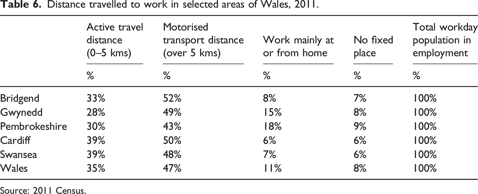
Source: 2011 Census.
These findings fit with the idea of meso-scale approaches to reducing car-dependence, introduced earlier in the paper. On this basis, what are the policy implications in thinking through where and how to move in the direction of 15/20-minute places? Given the variabilities in settlement and mobility patterns that we have highlighted in this analysis, the policy and actions developed to enhance active travel and public transport in Wales need to reflect these varied starting points. For example, in the most car-dependent places in our analysis, like Llansamlet and Coity, a different approach is appropriate, compared with the legacy 15/20-minute places.
Overall, reducing car use by modal shift to active travel and/or public transport is likely to require combinations of actions to make different choices possible and attractive. These will shape location and movement choices. In relation to location, planning policy and practice in Wales is mostly focused on adaptation of existing settlements rather than design of new ones, but actions can be taken, for example, on prioritising in-town brownfield sites, rather than edge or out-of-town sites for increases in housing stock. Increases in housing density and variety to encourage more (and a more diverse) in-town population expands the possibilities for 15/20-minute living. The siting of retail, leisure and public services are also key decisions with lasting impacts on future transport choices for residents.
In relation to movement choices, reducing car use will depend on the availability and attractiveness of alternatives, as well as disincentives to use a car. The Centre for Cities report (Coombes and Rodrigues, 2023) exploring the prospects for meeting the Welsh Government target on reducing car use has focused on public transport as the alternative. The report argues that given low population densities in much of Wales, most of the contribution to modal shift will come from the cities, especially Cardiff. This would require ‘a set of bold interventions designed to both change the urban form of its cities and expand transport infrastructure’ (Coombes and Rodrigues, 2023: p. 3), including improving the capacity, network coverage and reliability of public transport, as well as locating homes around transport hubs. While the argument developed makes sense in relation to improving public transport in cities, it ignores the possibilities for a more distributed set of modal shifts across many, smaller places. As we have shown, the large number of journeys less than 5 km suggests potential here for shifting some of those relatively short trips from car to active travel. There are, of course, significant challenges in relation to safety and terrain. Safer routes for active travel – including those that connect to public transport infrastructure – are a pre-requisite, while increasing availability of e-bikes can make cycling more accessible, especially in more hilly places.
Encouraging modal shift away from cars will depend on the co-ordinated use of policy and implementation in relation to planning, transport and public services locations. In deciding where best to target such measures, better information is required. While we have been able to use travel to work data from the UK Census in the analysis for this paper, this would be more meaningful alongside other data that covers journeys for other purposes and also the way that journeys are linked or chained. On this basis, the current plan to develop a new National Travel Survey for Wales (Transport for Wales, 2022) provides an opportunity to improve the range of data for small as well as large areas, as well as its relevance for encouraging modal shift. However, there is also potential to use deep-dive, place-based studies to understand travel decisions by different groups in a specific locational context. As well as a better understanding of the scope for modal shift, this would allow experimentation with co-ordinated policy and actions to support a move towards 15/20-minute living. Choosing places which start with some of the preconditions, especially a live-work base of residents, would allow better understanding of whether and how this can be built upon, rather than relying on high level strategies and targets.
Conclusion
In line with current global interest in 15/20-minute neighbourhoods and sustainable transport, Wales has an ambitious policy agenda to reduce car use, by promoting active travel and improving public transport, as well as by encouraging remote working. Yet like many other countries with substantial rural and suburban populations, it starts from an unfavourable base of high car use. Moreover, Welsh Government forecasts show that the overall distance travelled by private car will increase by a further 16.7% by 2030, if no meaningful action is taken (Welsh Government, 2020). The objective of this research was to explore Welsh mobility patterns in the context of different kinds of places, including the small towns, urban districts and suburbs in which most of the Welsh population live. This has allowed insights into the potential to reduce car use to apply the 15/20-minute place vision in ordinary places outside large, relatively densely populated cities.
It is not possible in this paper to provide a comprehensive analysis of all Welsh places or even types of place, but rather to examine a selection of representative neighbourhoods in order to open up a discussion about the possibilities for implementing a concept which has gained widespread currency and is now informing the development of strategies and policies in Wales. While more detailed cases would no doubt uncover more nuance, the analysis presented already highlights key points with relevant policy implications.
The paper has confirmed that car-dependence is a structural feature of Welsh settlements: not only across rural and peri-urban areas, but also in urban areas. Low density, dispersion between work, live and shop amenities, car-centred workplace locations and residential areas make the car not only the most convenient but often also the only means of transportation. Yet the analysis also suggests that Wales has a range of settlements – mainly towns centres, city centres of major urban areas and some mixed-used urban neighbourhoods – which are high density or mixed-use. Some of those places – like the city centres of Cardiff and Swansea – already work as fairly liveable places with high rates of active travel and public transport usage close or beyond the national policy target of 45% of journeys. Others – like mixed-use towns centres and urban neighbourhoods – are largely car-based because of their integration in wider car-dependent territories, but do possess the spatial precondition to increase the proportion of public transport use and active travel and move in the direction of a 15/20‐minute place.
From a policy perspective we see this research as having three key implications. The first is that policy needs to embrace a more discriminating view of places while focusing on the relation between settlements structure and transport patterns. Current high level conceptualisation of transport patterns in Wales are either ‘spatially blind’ or based on simple dichotomies; this risks the persistence of metrophilia (Waite and Morgan, 2019) and a lost opportunity to develop a more nuanced understanding of how car use can be reduced in a variety of ways in different places. The background report of the Welsh transport strategy (Transport for Wales, 2020) offers a thorough analysis of transport patterns with in-depth discussion of the relation between transport and variables such as the environment, health, gender, culture and economic development. However, there is no equivalent analysis for the relation between mobility patterns and place.
While we would agree that the Cardiff urban area is the most suited for a modal shift, due to higher densities, a centralised employment base in the city centre, a larger (almost metropolitan) size and a stronger public transport network, as argued by the Centre for Cities, this reading is based on significant limitations. Most immediately, following the analysis in this paper, it downplays the differences within places. This risks both over-estimating the potential for a sustainable modal shift in urban areas like Cardiff because of the car-dependent nature of the suburbs; while also ignoring possibilities for more sustainable travel in towns and city centres all across the country. This argument also leaves unanswered the question of how to promote sustainable mobilities – and in doing so reduce the significant inequalities that result from lack of access to cars – for the majority of the population of Wales who do not live in the core of the major urban areas.
The second policy implication is the need for Welsh policy to align transport policy and town planning. This research shows that Wales is a mosaic of places with very different transport challenges, which are largely place-related. Some already work as 15/20-minute places; others could work better with some key improvements, while others lack the minimum requirements for active travel based living and public transport provision. In this context, shifting mobility patterns is partly a matter of providing good quality alternatives to car use. But, the scale of the potential shift would be magnified by also increasing the number of people who live, work or shop in places which are not structurally dependent on cars. In this, the role of town planning will be crucial in preventing new out-of-town developments that only worsen car-dependence, by encouraging creative re-use of urban spaces for living and for working, and by developing new approaches to existing suburban areas to bring more amenities – including remote working sites – to places where people live.
The third implication is the need to also discourage car use more explicitly, and this may appear to present the most difficulties. Even with better public transport and more active travel, car use may still be considered more attractive or convenient and modal shift may be limited. There is much to be learnt about how measures to discourage or restrict car use can be employed in parallel with actions to enhance alternatives. There is evidence about the effectiveness of a range of actions to reduce car use in cities (Kruss and Nicholas, 2022), including congestion charges, workplace parking levies, car sharing and work or school transport planning. The adoption of electric vehicles offers some general benefits, such as reduced air pollution, though take-up is slow and spatially uneven. However, even with more widespread use, electric vehicles offer very little to the objective of making places more liveable by reducing car-dependence: in terms of the hierarchy of ‘avoid, shift, improve’ (IPCC, 2022: pp. 508-09), they are part of the third-best, improvement, as they represent a technology change not a change in movement patterns or modes of travel (UNECE, 2020: pp. 178-81). This only reinforces the need for creative thinking about measures to reduce car-dependence specifically for smaller towns, urban districts and suburbs.
Footnotes
Declaration of conflicting interests
The author(s) declared no potential conflicts of interest with respect to the research, authorship, and/or publication of this article.
Funding
The author(s) received no financial support for the research, authorship, and/or publication of this article.