
Abstract
While a rich body of work on nations and national borderlands has demonstrated how the ideal of the nation state resulted in ever greater (and often violent) demands for geographic fixity, this article shows how territorial visions of regional communities permitted a tremendous level of flexibility and were able to hold highly divergent geographic imaginings in suspension. The article seeks to demonstrate this by looking at a unique moment in post-war West German history when spatial planers, parliamentary committees, regionalists and an army of experts sought to determine the boundaries of regional belonging in preparation for a planned redrawing of the West German federal map. Many believed that a viable federalist democracy required stronger federal states rooted in a sense of regional community. The states created by the Allies were initially seen as temporary, and Article 29 of the new constitution required that states be redrawn by considering boundaries of regional belonging. The intense efforts of experts, politicians, and regionalists, however, ultimately failed and revealed widely diverging ideas about which territories corresponded to a common sense of regional community. Conflicting historic state borders, the historic force of physical geographies, confession, orientation to urban centres, a profusion of dialect borders, and regional cultural practices all shaped geographic visions of region, but simultaneously underpinned widely-variant cognitive maps. While the failure to redraw the West German map resulted in this episode of history largely being forgotten, I argue that it speaks volumes about how forms of community beyond and beneath the nation state have been imagined in territorial space.
Keywords
The question of ‘where’ a particular nation could be found in geographic space has long played a central role in a range of national historiographies. This is perhaps nowhere truer than for German history. Few scholars will be unfamiliar with the iconic question of Goethe and Schiller posed in 1797: ‘Germany? But where is it? I know not how to find such a country’. 1 As Helmut Walser Smith has recently shown, efforts to map ‘Germany’ began already in the early modern period, though such maps were filled with shaded areas, dotted lines, and representations of ambiguity. Demands for absolute fixity, he concludes, were the product of a modern age when the idea of nation was wedded to that of the modern state. 2 Over the past several decades, historians have devoted much attention to modern conflicts over the geographic contours of national communities – and for good reason. Such contestations underpinned histories of violent struggle throughout the nineteenth and twentieth centuries. For the historian Charles Maier, the pursuit of an overlap between national ‘identity space’ and ‘decision space’ was one of the foundational trends of modern history and the hallmark of what he refers to as a ‘territorial age’. 3
The nation state, however, was not the only form of territorially imagined community. Much evidence, moreover, suggests that the modern ideal of the national community as the primary source of political sovereignty made the dynamics of imagining it in territorial space rather unique. Instead of focusing on territorial imaginings of national community, this article looks to modern regional communities, which help shed light on what cognitive mapping of modern communities looked like with absolute claims to political sovereignty taken out of the picture. More specifically, this article looks at a revealing moment in modern German history when experts and regionalists sought to ‘discover’ the borders which separated regional communities and cultures.
The history of regions and regionalism in modern Europe has long been a rich field of research. While many works have shed light on the relationship of regional and national identities, less attention has been devoted to how modern regional communities were cognitively mapped. 4 One of the few possible exceptions can be found in studies of nationally contested border regions, which have provided some examples of how national contestation reshaped ideas about which territories belonged to a common region. 5 Unlike modern nation states, however, regions laid claim at most to partial forms of sovereignty and sometimes were only cultural ideas without any correspondence to national territorial subdivisions. The idea that regional ‘decision spaces’ should overlap with regional ‘identity spaces’, moreover, was far weaker and often inconsistent. But how did modern denizens forge cognitive maps of regional communities? Can we see the same impulses towards ‘fixity’? What role did geography, dialect, religion, or political borders past and present play in shaping cognitive maps? Did the interplay of these factors yield stable and commonly shared cognitive maps? If any nation in modern European history had clearly defined regions, Germany would seem a prime suspect given its strong federalist histories.
Regional political borders in German history, however, were never formed by first looking descriptively at which peoples saw themselves as belonging to a common region. The re-drawing of the map under Napoleon is a classic example, with random states drawn according to raw power politics followed by subsequent efforts to instil denizens with regional identities. 6 This article, however, examines a telling moment in the early post-war years when experts and regionalists in West Germany sought to work the other way around: asking first what territories corresponded to regional feeling in preparation for an anticipated redrawing of the federal map. While the history of these efforts has largely been forgotten, appearing chiefly on the margins of political histories of West German federalism, they offer rich insight into how modern regions were imagined in geographic space. 7
The federal states which eventually became permanent fixtures of the new Federal Republic traced back, for the most part, to the interim states created by the allies based on temporary administrative considerations. Both the Allies and the West German state saw them as temporary. Many federalist enthusiasts, meanwhile, maintained that decentralizing the new republic required not only a sub-national division of power, but also federal states rooted in regional community. In 1948, the Allies issued guidelines for the formation of a West German state, which included directives that a new federal government must redraw its regional state borders. 8 The Parliamentary Council which drafted the ‘Foundational Law’, in turn, included Article 29 which declared that the new republic must redraw the federal states according to regional feeling, historical connections, and social and economic viability. 9
The constitutional requirement triggered the mobilization of a vast scholarly and bureaucratic apparatus to determine the boundaries of regional belonging. It included politicians, geographers, historians, political scientists, linguists, folklorists, and dialect experts, among others. It saw the drafting of hundreds of reports on different aspects of regional belonging submitted to a new parliamentary committee tasked with redrawing the entire map. The issuance of the committee report was followed by a brief legal window in which regionalists in a portion of the country were allowed to gather signatures to hold referenda on creating new states.
This article probes these attempts to find the borders of regional belonging. It begins with a reflection on cognitive mapping, earlier territorial patterns in German history which would shape the debates, and an assessment of the historical context in which the post-war re-bordering efforts unfolded. It continues by examining the diverse approaches which post-war experts took, from examination of dialect borders to physical geography, ancient ‘tribal’ borders, confession, shifting political borders, memory of past state forms or the radiating influence of cities. The final part of the chapter looks at how regionalists themselves advocated for their own conflicting maps of regional belonging.
As such efforts illustrated, the potential factors which could influence territorial imaginings of region was staggering. It is not the intention of this article, however, to integrate these myriad forces into a universal model which claims to explain how every potential imagining of region worked. Needless to say that simplistic explanations would hardly do, and the study of individual regions reveals the complex and inevitably contingent nature of such processes. This article is instead interested in the degree to which regional communities required uniformity in their imagined geographic contours.
The history of efforts to redraw the West German map, this article concludes, ultimately demonstrated how modern regional communities permitted far greater diversity in understandings about their contours, defining characteristics, and geographies compared to modern nation states. Neither experts nor regionalists were able to find commonly agreed upon borders because such borders did not exist. Cognitive maps of region often proved even more variant than the earliest territorial imaginings of nation in previous centuries, with conflicting geographic imaginings crisscrossing the core point of other cognitive maps of region. While the West German state would quickly abandon efforts to redraw its interior borders according to regional feeling, the fleeting history reflected how regional communities lacked the same impulse towards fixity which could be found on the level of the nation state.
Cognitive Maps and ‘Partial Sovereignties’
In using the term ‘cognitive maps of region’ this article refers quite simply to those regional geographic spaces with which individuals consciously identified. The term ‘cognitive map’ was itself first coined in the late 1940s, and the earliest thinkers who used it thought not of nation or region but rather about individual engagement with everyday spaces. First used in psychology, the term was increasingly taken up by geographers by the 1970s. In a joint work on the concept from the decade, the geographer Roger Downs and the psychologist David Stea asked how similar individual maps of the same places were. Cognitive maps, they argued, were tools used to deal with the ‘staggering volume of potential spatial information’ and were necessarily selective, involving a mixture of fact and fiction. 10 While earlier scholars had asked how ‘accurate’ cognitive maps were, Downs and Stea pointed out that the question problematically posited an accessible ‘objective’ map of place against which cognitive maps could be measured. While similar cognitive abilities and behaviour patterns would result in some similarities, they concluded that cognitive mapping was deeply subjective given the personal nature of experiences and the meanings attributed to them. 11
Historians, though seldom engaging with the earlier work of psychologists or geographers, increasingly took up the term in research into the larger-scale ‘imagined community’ of the nation. 12 The forces pushing for collective agreement in ‘cognitive maps’ of the nation were hardly restricted to similar ‘cognitive abilities’ or patterns of behaviour. Such processes were embedded within powerful political movements, the emergence of ideas of the nation as the fundamental source of political legitimacy, and the ‘totalizing classification’ of nation-building processes. 13
In terms of scale, regions lay somewhere between the kind of everyday spaces which the first theorists of the concept considered and the nation states which so preoccupied historians. Unlike nationalists, political regionalists laid claim at most to what in the German context has been referred to as ‘partial sovereignty’ (Teilsouveränität). 14 By its very nature, ‘partial sovereignty’ cannot be precisely delineated for the simple reason that it was defined by ambiguity and historical contestations about what it should entail. It can perhaps best be defined ex negativo: it did not involve claiming to be a nation state but was also not fulfilled by a purely cultural form of regionalism in which the region relinquished claims to accommodation within state structures.
There is little reason to think that determining the borders of regional feeling would be any more difficult in the German lands than in other national contexts. But the longer tradition of thinking about Germany as a ‘federative nation’ meant that Germans tended to face the ‘where is the region’ question more often. 15 Revolutions and the aftermath of wars particularly represented moments when Germans confronted changes or proposed revisions to its interior state borders. 16 To fully understand the post-1945 debates, a brief glimpse at these longer histories is needed. The territorial history of the German lands offered post-war regionalists a dizzying array of contradicting borders and reference points. Going back to the early Middle Ages, the Germanic tribes and medieval tribal duchies had left an imprint on regional cultures and dialects but had broken down in the late Middle Ages. The fragmented borders of early modern states, meanwhile, fluctuated at a bewildering pace and had witnessed dynamic processes of confessionalization and state-building. In the early nineteenth century, Napoleon's sweeping territorial revisions of the German lands particularly reduced fragmentation and substantially consolidated states. Given how these states were drawn purely based on politics, dynasts and provincial elites made great efforts to subsequently promote regional identities for their new territories. They continued to advance them after national unification, during which Bismarck adroitly used federalist structures to keep a lid on potential regionalist conflicts. 17
Regionalism, however, was not simply a top-down phenomenon, and scores of different groups promoted regional consciousness after the birth of the ‘Heimat movement’ in the late nineteenth century. The term ‘Heimat’ which gained tremendous popularity in regionalist movements, referred to a sense of home and belonging in local and regional places, and represented a key word in the articulation of ideas about Germany as a nation of diverse regions. Prominent actors in regionalist movements included the educated bourgeoisie, hobby historians, local teachers, clerics, local notables, folklorists, and a range of others, while regionalists often framed themselves as bridging narrow partisan camps. 18
If any period pre-figured the post-1945 confrontation with the ‘where is the region’ question, it was the Weimar years, during which many proposed redrawing the federal states. The turbulence of the period threw up regionalist questions in a major way, with a decade-long debate over proposed ‘Imperial Reforms’. As Jasper Heinzen has demonstrated, many of the regional conflicts which the Second Empire had effectively contained erupted. 19 Interwar proposals to redraw the federal states were complex and were embedded in proposals to fundamentally overhaul national constitutional structures. 20 The dominant position of Prussia was a particularly contentious issue. As Heinzen demonstrates, federalists who argued for Prussia's dissolution often pursued ideas of redrawing German states according to ‘tribe’ – an imprecise concept whose borders regionalists were unable to agree upon, all the while insisting on them as the basis of regional self-determination. 21 Given the breadth and complexity of the proposed Imperial Reforms, however, it can be easy to miss the extent to which it revealed conflicting territorial imaginings of region. 22
After the seizure of power, Hitler sought to shut down these territorial debates after overhauling the administrative structures of the state. 23 The network of regional Gauleiter and Reichstatthalter, however, evoked and sometimes invented regional concepts to solidify their own positions or increase the territories under their jurisdiction. 24 As several scholars have demonstrated, the regime often sought to use regionalism in propaganda and made great efforts to channel its energies outward. 25 Still, it did not hesitate to push against strains of thinking about regionalism which it saw as too inward or detached from the war effort. 26
A Nation of Regional ‘Heimat States?’
The German people, so an early post-war Heimat society in the town of Oldenburg argued, needed to create a federalism based on ‘Heimat states’. Thrusting citizens into random states, they argued, would leave them only with national feeling but deprive them of the crucial mediating feeling of Heimat. 27 Oldenburgers were not the only ones after 1945 who advocated for states based on Heimat feeling. Many regionalist federalists throughout the early Federal Republic argued that it was crucial for building a new democracy. As one Baden town mayor argued, federalism was not simply a technocratic project, it must also be the subject of ‘feeling’ (emphasis in original). They had had enough of ‘choking unitarism’ during the Nazi regime, he argued, and needed regionalist states to resist the threat of a centralist Bonn. 28 Many federalist politicians similarly argued that avoiding a backslide into dictatorship required a robust federalism rooted in regional community. 29
Post-war West Germany, as Yoshiro Iida has argued in his study of interwar Imperial Reforms, enjoyed a much a stronger consensus in favour of federalism than Weimar Germany. 30 Both the allies and many West Germans described federalism as a counterpoint to centralism as a ‘Prussian’ tradition which needed to be abandoned in the wake of National Socialism. As Siegfried Weichlein has noted, West German sentiments and allied interests very much dovetailed in the construction of new federalist structures. 31 The geometry of discussions about redrawing the federal map in West Germany, moreover, was not as entangled in many of the intractable issues which dogged the Weimar Republic. The Prussian state, whose dominance had been such a thorny issue, disappeared. The question of redrawing state boundaries was also not as enmeshed in proposals to totally revamp constitutional structures as it had been in the Weimar years. The post-1945 period was also more defined by centrism and consensus politics. Questions of what territories constituted the ‘region’, though still quite contentious, could thus be confronted in a somewhat more disentangled way and with a bit more sobriety than in the Weimar years. Disaggregating regional border questions from many of these contested issues also made it all the easier to see how territorial imaginings of belonging diverged.
Anticipations that the entire federal map would be redrawn were also higher in early post-war West Germany. The Allies ordered a future West German government to redraw its borders, though they left it to the Parliamentary Council, which drafted the new state's ‘Foundational Law’, to hammer out the details. The council included vocal advocates of creating states based on regional feeling, including the Rhenish politician and avid federalist, Adolf Süsterhenn. 32 Süsterhenn played a key role in drafting Article 29, which mandated that new states must be delineated based on ‘cultural and historical connections’ and what drafters referred to as ‘landsmannschaftliche Verbundenheit’ – a peculiar and virtually untranslatable phrase which suggested a sense of connection and togetherness with people in a particular landscape. Economic factors, social structures, and administrative aspects of geographic scale were also to be considered. 33 Nearly all noted the peculiarity of the term landsmannschaftliche Verbundenheit. 34 Constitutional drafters, legal experts, and academics, however, all confirmed that the term was legalese for a common sense of regional Heimat. 35
Academics, constitutional commentators, and spatial planners all therefore approached the term as referring to a sense of regional belonging. 36 The Academy for Spatial Research and State Planning (Akademie für Raumforschung und Landesplanung), for example, argued that the outlined requirement referred to regional spaces shaped by feelings of Heimat, tradition, and belonging. 37 Werner Münchheimer, a scholar deeply involved in plans for border redrawing, concurred, arguing that landsmannschaftliche Verbundenheit was an emotional principle informed by subjective factors and lived experience, including childhood memories, domestic warmth, and consciousness of the past. It was a ‘superordinate term’ for all ‘feeling of belonging in Heimat’. Such entities, he argued, had the right to be states. 38
The Parliamentary Council made one exception to Article 29, which applied to the three awkwardly-shaped and unsustainable states of the German Southwest, whose borders the French and American occupiers drew according to a motorway (Figure 1). Article 118 held that their three state minister presidents could determine new state configurations through common agreement. Since they failed to agree, the second clause mandated a vote. The subsequent Southwest State debates of the early 1950s demonstrated how regionalists in the area had scores of conflicting cognitive maps of region. Debates over restoring or unifying Baden and Württemberg in the Southwest also involved heated debates about the importance of region to democracy. 39
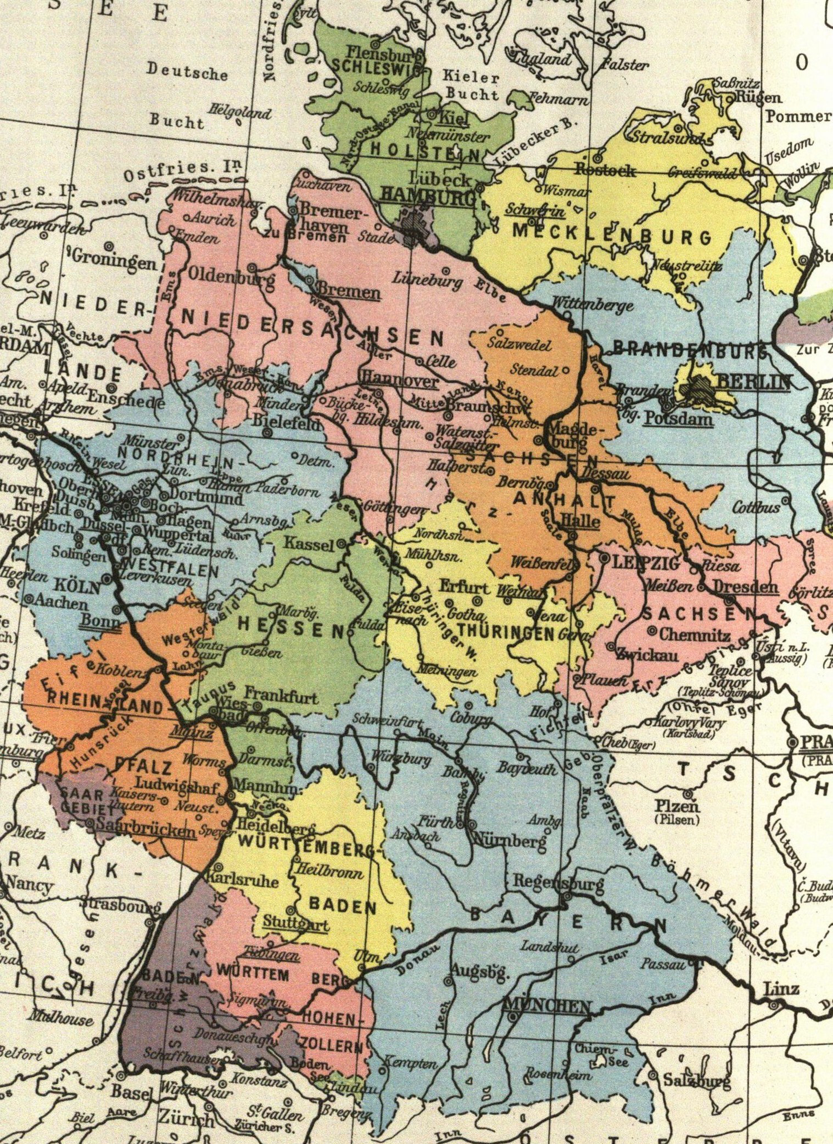
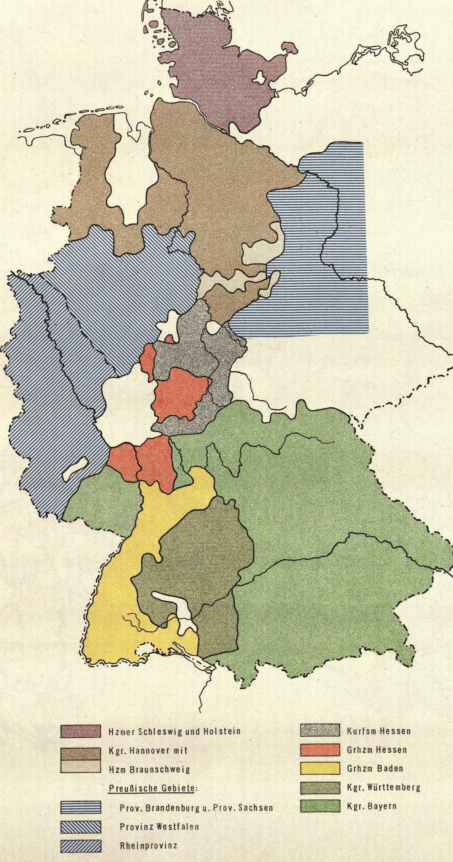
The federal states of West and East Germany in 1949
Efforts to redraw the federal map began with a series of state minister conferences. Preparing for the conference, Münchheimer looked back to proposals to redraw the map of the Weimar Republic. Laying diverse Weimar-era proposals onto one another, he sought to discover ‘core landscapes’ that could act as starting points. 40 The minister conferences, however, failed to reach any consensus. Two subsequent parliamentary committees were then called to address the issue. The first, the Euler Committee existed from 1949 to 1950, but also failed to present a map proposal. The committee merely outsourced its work, contracting reports from two competing geographic institutes, the newly-minted Institute of Spatial Research in Bonn and the Academy for Spatial Research and State Planning. The former reported that no single ‘useable map’ existed which reflected borders of regional belonging. It produced a massive list of 226 historical and cultural regional maps and atlases, drawn according to different principles. A new map, they insisted, had to be created. 41 After a year, no closer to a solution, the committee dissolved, presenting a list of the 14 most intractable problem areas. 42
The Euler Committee was replaced by the Luther Committee, which was given three years to draft a new map for an up or down vote in the Bundestag by January 1955. The committee consisted of an army of 40 members and associated experts and was headed by the former Weimar-era chancellor, Hans Luther. While his direct ancestor, Martin Luther, had notoriously traversed Germany on foot, Hans Luther and his fellow committee members did so by train, often noting how they saw regionalists waving flags along the train route as they passed. 43
The Luther Committee assembled a massive list of scholarly literature on regional histories, politics, dialects, and traditions, and contracted hundreds of expert reports, none of which brought clear answers. 44 In contracting reports, the committee drew on academic geographers throughout West German universities and did not exclude unsavoury figures who successfully re-established their careers after working for the Nazi regime. This included Hermann Aubin and Erwin Scheu. Aubin, who preferred the idea of ‘tribe’ to regional Heimat, sought to pre-empt notions that he would produce ‘blood and earth’ propaganda, while his colleague Scheu held that regional Heimat feeling should only be spared when preponderant practical considerations did not indicate otherwise. 45 The committee and its army of experts, however, did not control the conversation. In the academic realm, federal states contracted their own reports, while other academics took up the study of particular regions of their own volition. In the popular realm, discussion about regional belonging took place across newspapers, regional journals, Heimat societies, and referendum debates.
The work of the Luther Committee would ultimately fail. While its reports demonstrated extreme variances and inconsistencies in cognitive maps of regional community, it would rubber-stamp the legality of the random states created during occupation as fulfilling the obligations of Article 29. In making sense of the flurry of studies and contracted reports that its work generated, insight can be most easily gained by looking thematically at the different factors which experts focused on to discover the boundaries of regional belonging. What influence, for example, did dialect borders, confession, or the settlement patterns of the Germanic tribes have on regional culture? What was the influence of nineteenth-century states which had pushed their own regional propaganda? What of physical geography? While experts had their own opinions on the subject, so too did regionalists at the ground level.
The Slippery Concept of ‘Stamm’
If the drafters had anything to look back on, it was proposals to redraw Weimar-era states according to ‘tribe’ (Stamm). The term ‘tribe’, however, does not accurately capture the fluid meaning of the German term ‘Stamm’. On the one hand, the word was used to refer to the ancient Germanic tribes and the influence of their settlement patterns on regional culture. The tribal duchies shaped medieval German history and strongly influenced modern German dialect borders. (Figure 2) But Stamm also implied a general sense of common origins. In the popular realm, the term became a synonym for a sense of regional belonging projected into a vague past which sometimes had nothing at all to do with the Germanic tribes.
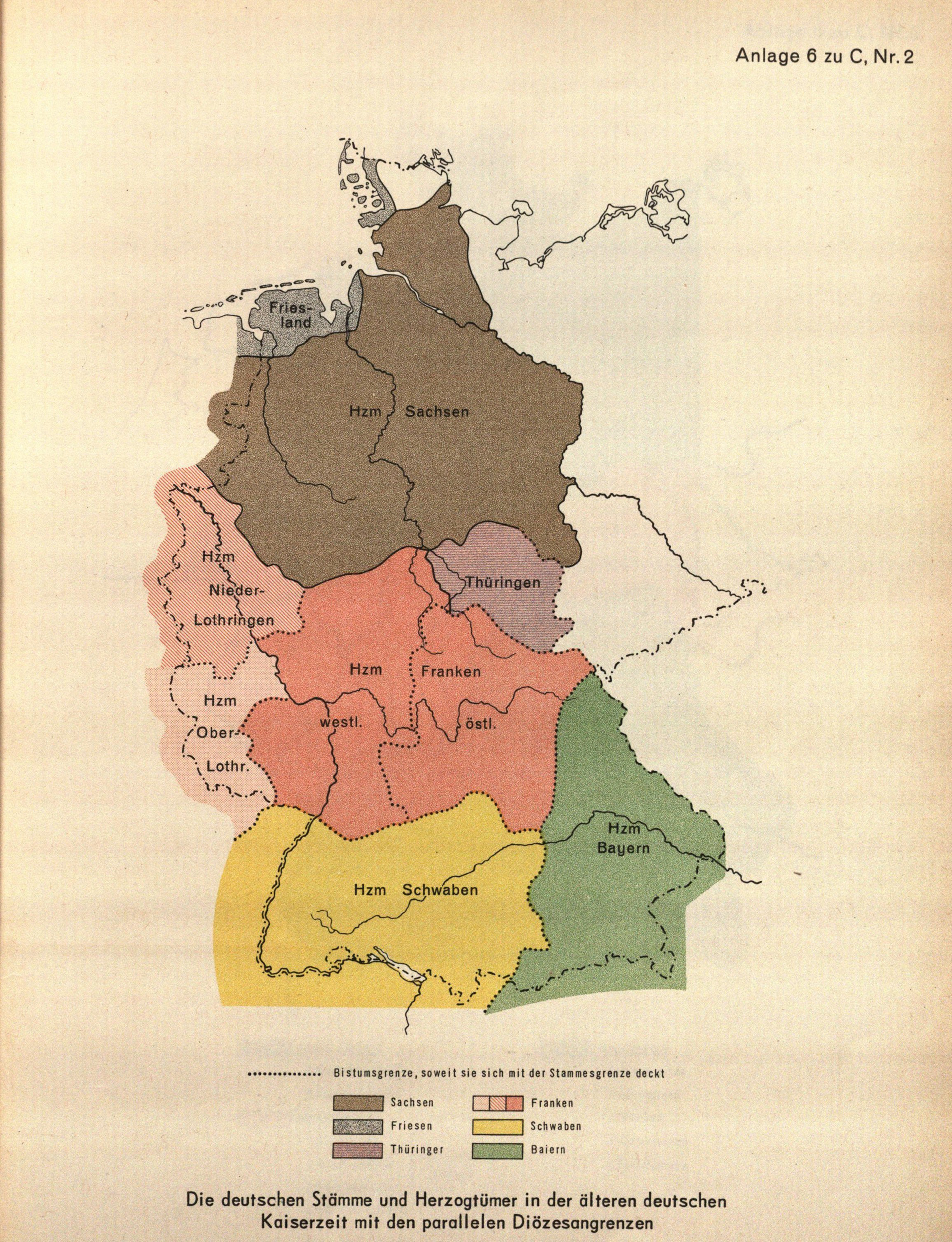
Early Medieval tribal duchy borders as mapped in the final Luther Committee report (Friesland, Saxony, Upper and Lower Lorraine, Thuringia, Franconia, Swabia, and Bavaria). Colours represent tribes, while light dotted lines represent diocesan borders
While ‘Stamm’ found appeal amongst diverse political groups in the Weimar era, few had clear answers about which ‘tribes’ constituted the nation. As the Hamburg scholar, Kurt Stavenhagen, noted, almost no one in the Weimar era seemed able to list them. Are the Prussians a Stamm? he asked, reflecting on the fact that there had been no Germanic tribe by that name. What about so-called ‘sub-Stämme’? Tribal settlement patterns, he pointed out, no longer reflected notions of regional community in many areas, such as that of the Franconian Stamm which included the Rhineland and the Palatinate, where denizens no longer identified with the idea. Nor could one easily find exact borders between the settlement areas of the Germanic tribes, which had intermingled and overlapped. 46
In the Weimar Republic, Hugo Preuß and other democratic thinkers supported creating new states based on Stamm but did not delineate them beyond noting that they were not the nineteenth-century dynastic accidents of birth. 47 Coming from a more reactionary and nationalist perspective, the literary scholar, Joseph Nadler, did list them. He delineated a ‘German-Roman’ group including Thuringians, Bavarians, Alemanni, and Franconians, and a German-Slavic group made up of Saxons, East-Middle Germans, and East-Lower Germans. Some historic factors, he noted, appeared to tear these groups apart, like the Rhine carving ‘Rhinelanders’ out of the Franconian Stamm or the Swiss abandoning ideas of themselves as Alemanni. But consciousness of belonging was, for Nadler, irrelevant. 48 Other Weimar-era scholars denounced such racial interpretations. 49 The geographer Hans Schrepfer noted the same inconsistencies in identification with Stamm and argued it should only be considered where they remained in popular consciousness. 50 The interwar Austrian-Jewish scholar Friedrich Hertz, meanwhile, argued that the concept was extremely flexible and immensely difficult to delineate. 51
Experts in early West Germany found the same inconsistencies, uneven identifications, and clefts in usage of the term. 52 In his report on Lübeck, for example, the Hanseatic historian, Ahasver von Brant, reported that the town culturally belonged to the same Stamm as the rest of Schleswig-Holstein, but did not identify with it. 53 Yet another report held that Schleswig-Holsteiner did not even belong to a common Stamm and were shaped by different Stämme whose vague borders could be seen in fuzzy zones of transition of regional culture, dialects, place names, and building styles. 54 Curiously, one report noted that Lippe, in the Teutoburger forest, was part of the Westphalian Stamm (an ancient ‘Westphalian’ tribe never existed). The report concluded, however, that Lippe did not identify with it, having developed a separate ‘Heimat feeling’. 55 The German Southwest reflected the same indeterminacy. While the committee determined it was unified by a Swabian-Alemannic Stamm, they noted how consciousness of this had blurred. Many in the nineteenth-century ‘accidental state’ of Baden, moreover, began to identify their state with what they described as a separate ‘Alemannic’ Stamm. 56 Other vagaries came from the fact that early medieval tribes had themselves not had clear dividing lines. Reports, in turn, referred to ‘partial Stämme’, ‘young Stämme’, ‘new Stämme’, and ‘intermediate Stämme’. 57
Given the conflicts and disparities around Stamm, the Luther Committee's final report referred to the term inconsistently when describing the boundaries of regional belonging. In rubber-stamping the legality of the state of Rhineland-Palatinate – a state that a host of regionalists were eager to tear apart – the committee signed off that the state technically fulfilled the constitutional requirement given that all its territories were within the boundaries of the old Franconian Stamm. West Franconian areas, however, spread much beyond the state borders and committee members confessed privately that little joined the state together culturally. 58
If identification with ‘tribe’ proved inconsistent, their settlement areas had influenced modern dialects. Dialect boundaries, however, proved even more unwieldy. As Luther Committee reports held, dialects often did not have clear borders and were separated by broad segue areas. Linguistic analysis merely bundled together diverse but related variations to establish simplified categories. 59 For linguists, literally thousands of dialect borders could be found. Many, but not all, were recognizable by everyday denizens. The appropriation of dialect borders as a marker of regional identities, moreover, proved inconsistent.
Drawing on the work of the nineteenth-century folklorist, Wilhelm Heinrich Riehl, the committee divided Germany into three broad cultural and dialect groups: Lower, Middle, and Upper German. At the same time, they noted tensions of such a model in public conception. The nineteenth-century Prussian influence in the north and memories of southern resistance had, in some areas, shaped a binary notion of southern and northern German cultures. 60 The relationship between Stamm and dialect families also proved controversial. A study commissioned by the state of Hessen, for example, claimed that Hessian dialect borders corresponded with Stamm and came close to its current state borders. A committee expert, Heinrich Landahl, however, rejected the assessment, pointing out that the northern and southern halves of the state spoke different dialects. The southern half, meanwhile, spoke a west Franconian dialect which spilled over its eastern border into the town of Aschaffenburg, which had been part of Bavaria for over a century. This evoked the question of whether Aschaffenburger identified with Hessians based on dialect or with Bavarians based on a century of dynastic statehood. The Spessart mountain chain directly east of the city formed a major dialect border within the entire Franconian dialect family, separating Rhine and Mosel Franconian to the West from the East Franconian dialects spoken in the rest of the northern Bavarian state. A common dialect, however, was not enough to forge full regional identification with Hessen, since Bavarian identity had made inroads over the last century. 61 Neither Stamm nor dialect, in short, offered conclusive answers in Hessen, Bavaria, or elsewhere.
The Power of Physical Geography or the Influence of Cities?
A toolbox of other factors remained to be considered. Several experts looked to physical geography, given how it shaped historical, cultural, and linguistic developments across the longue durée. The early post-war scholar, Wolfgang Bolten, in a work on redrawing regional borders, particularly promoted attention to physical geography. Rivers and drainage divides, he argued, did not constitute borders but rather ‘axles of collection basins’. In plain areas, he argued, forests and lowly-populated spaces acted as natural borders. 62 The report of the Institute for Spatial Studies similarly emphasized natural borders in finding ‘core landscapes’. 63 Others, however, were more critical. Münchheimer argued that drawing regional boundaries according to physical geography was a ‘Sisyphean task’. Nevertheless, when geography was considered, he advised long mountain chains as useful borders. The flow of water, Münchheimer argued, never determined ‘organic political borders’ in Central Europe, though tributary systems could be collective points of common regional cultures. 64 The final Luther Committee report also eschewed focus on physical geography, concluding that the idea of ‘natural borders’ was a cultural construct. The influence of a sea, mountain chain, moor, or forest landscape, the report maintained, was always situational. They agreed, however, that rivers were not proper borders, as they disrupt organic state foundations and regional orientation toward urban centres. Instead, borders should be placed in lowly populated areas. 65
Individual reports on geographic features’ impact on regional culture, moreover, often contradicted empirical observations of regional sentiment. In the Luther Committee report on Baden-Württemberg, for example, it was argued that the Black Forest did not represent a boundary between a Swabian and Alemannic regional culture, categorizing both sides as belonging to a single regional cultural space. 66 The Southwest state debates of the early 1950s, however, revealed that a number of regionalists saw it as a border. For Badenese regionalists, the nineteenth-century dynastic state border that ran through the forest fused with a weak dialect border, becoming the basis for imagining a new ‘Stamm’. (Figure 3) Other geographic features brought the same ambiguity. Peter Schöller, a geographer who conducted research on the Westerwald, a low forested mountain chain, found similar problems. It was, he argued, a fluid geographic area which was in tension between Rhine Franconian and Mosel Franconian dialects and the pull of competing cities. For his part, Schöller believed regional building styles and art offered a better means of determining boundaries. 67 The Luther Committee, meanwhile, concluded that the nature of regional belonging in the Westerwald would permit unification with territories in any direction. 68
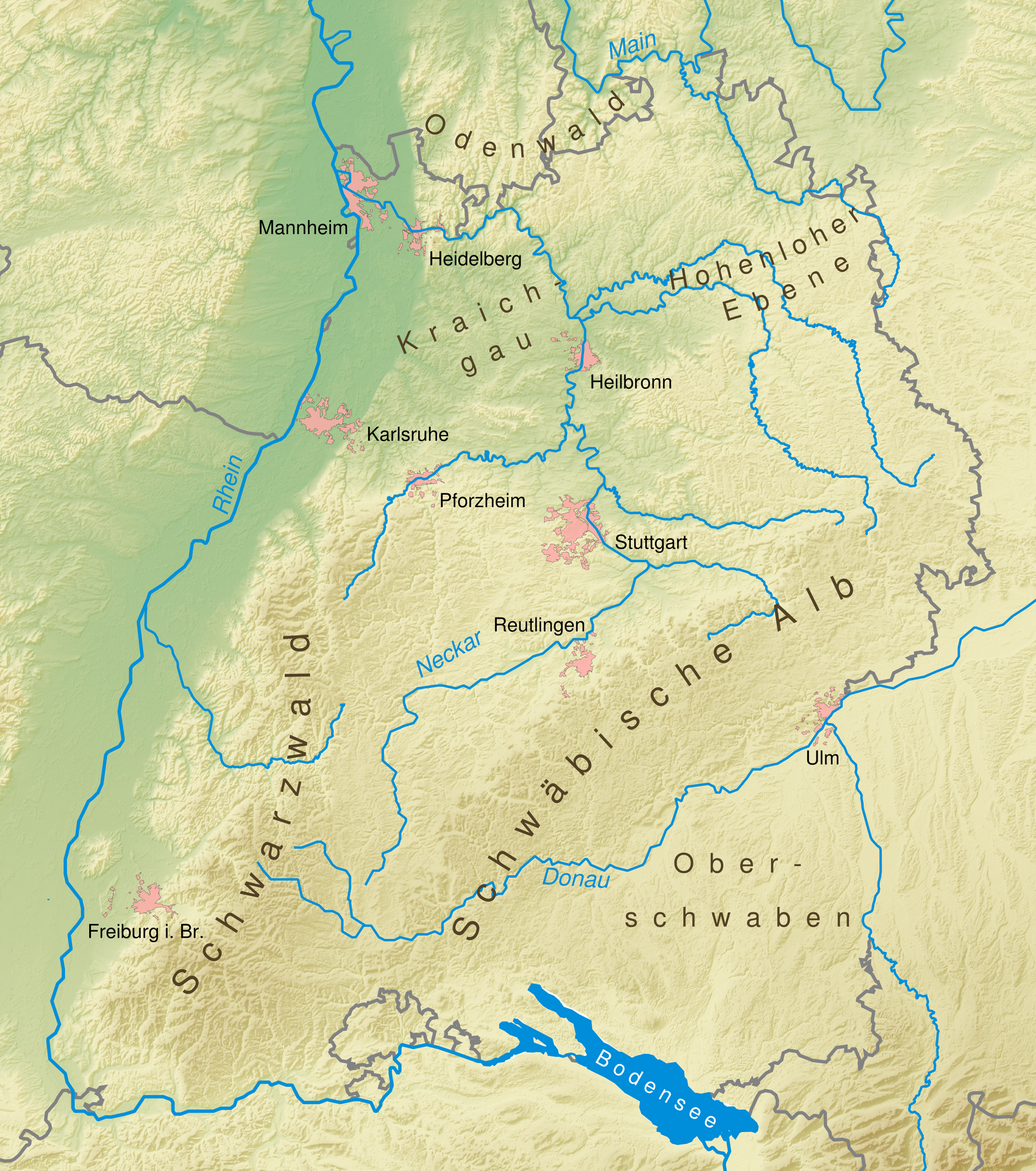
Topographical Map of Baden-Württemberg. The Black Forest (Schwarzwald) separated Baden and Württemberg at the southern end. Compare with dotted-line boundary between Baden and Württemberg in Figure 6
The committee report looked more favourably on what it referred to as the ‘City Principle’ – the idea that regional belonging was shaped by orientation to cities. The committee’s final report held that regional cultural spaces were not ‘isolated, full spaces’ but rather ‘radiating areas’ that emerged from urban nodes. 69 Such descriptions, however, also reflected a sense of fluidity and imprecision. The committee's use of the principle also left much unsaid. The region of Hessen, for example, represented, according to a committee report, the radiating influence of Frankfurt, Kassel, Wiesbaden, and Darmstadt. 70 No explanation was offered on why the radiating influence of these cities belonged in a common regional basket. The committee report did concede that some regions were difficult to conceive of in terms of urban influences, such as the German Southwest. Here the committee, determined that the Southwest was not oriented to cities but rather to three geographic radiating zones: Lake Constance, the Upper Rhenish lowlands, and a ‘Swabian core area’ (where this core lay they left undefined). 71
The City Principle, however, proved even more problematic than the committee was willing to publicly concede. Orientations to urban centres were overlapping, imprecise, reduced gradually in strength, and varied across different demographic groups. The City Principle proved particularly ineffective in rural areas. The Westerwald again offered a good example, being pulled in every which direction by the overlapping pull of urban centres. (Figure 4). The City Principle also could not explain cognitive maps of region which stretched across large spans of territory, nor could it account for identification with regions whose perceived borders ran through the centre of urban conglomerations. The population conglomeration of the Ruhr and Northern Rhine, including Essen, Dortmund, Duisburg, Bochum, Düsseldorf, Cologne, and Bonn provided a prime example. Denizens of the latter three cities traditionally identified themselves as Rhenish, while the former identified themselves as either Westphalian or more narrowly as Ruhrpottler. Ideas about what territories belonged to the Rhineland or Westphalia, however, remained tremendously unstable. The need to define a border through the middle of the conglomeration, however, was obviated by a consensus that they could share a common state for economic and administrative reasons while maintaining separate regional identities.
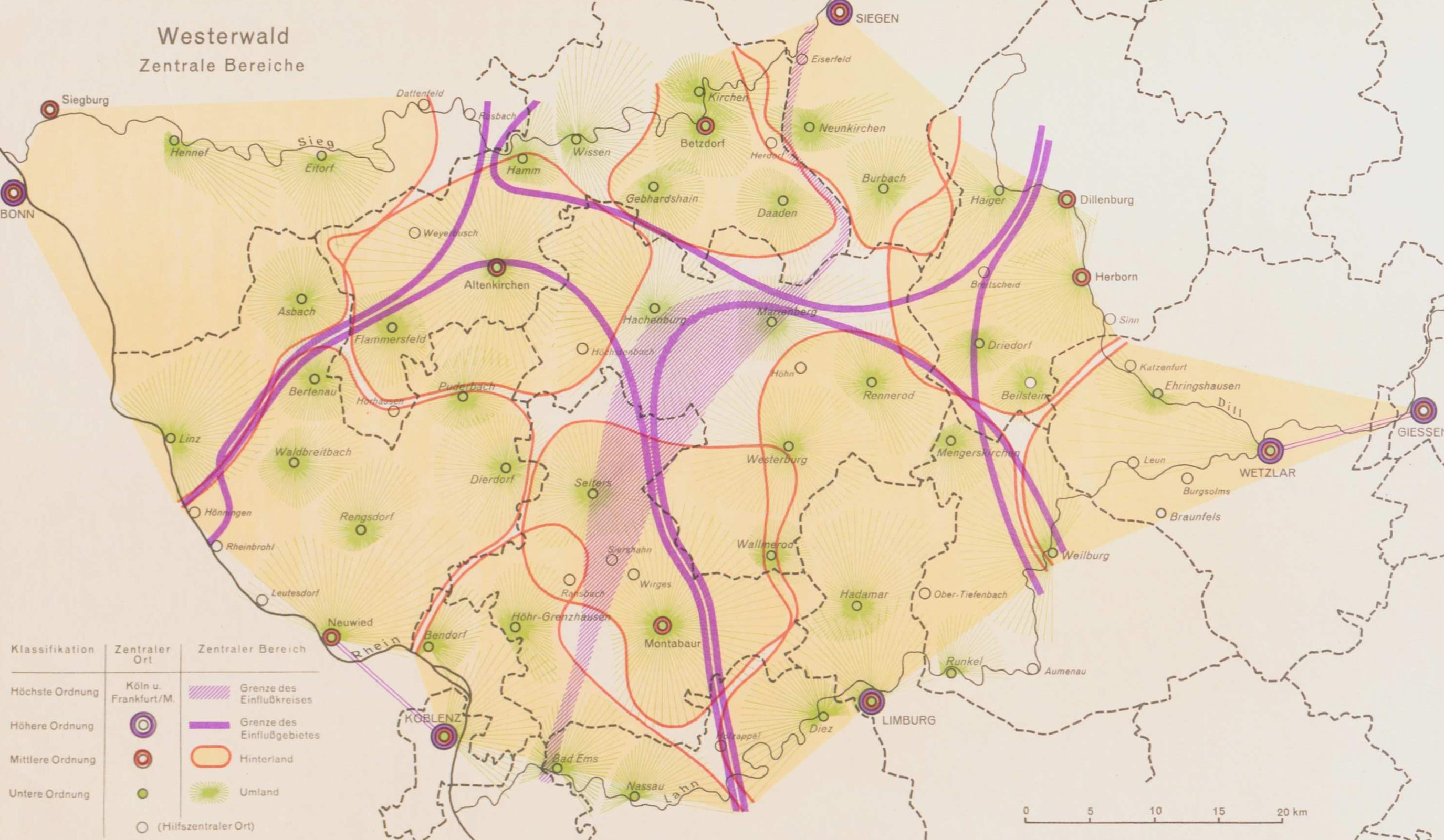
Map of cities in the Westerwald and urban zones of influence. Thick lines represent the pull of five medium-sized cities at its edges. The shaded zone in the middle represents the boundary between the zones of influence of Cologne and Frankfurt
Some looked to yet other factors. Confession, for example, had shaped the German map for much of its history. Regional enthusiasts of Bavaria, the Rhineland, Upper Swabia, and Baden often affiliated regional natures with Catholicism, while many northern German territories identified regional culture with Protestantism. Nevertheless, confession proved of limited usefulness, given how nineteenth-century regional states mixed confessional populations and later population movements variegated confessional geographies. Yet other cultural factors could be considered, including regional food and drink, regional dress, flora and fauna, or regional art styles. 72 The geographic borders of private societies, institutions, and publications could also influence cognitive maps of region. The Luther Committee recognized this, drawing up a 40-page list of private organizations and their institutional borders. 73
The Force of Regional Decision Spaces
One of the most contentious factors with which experts grappled was the role of modern dynastic states and other regional decision spaces. The dynastic states of the nineteenth century had been shaped purely according to political consideration, while eager dynasts had subsequently pushed new regional identities. Even Prussian provinces managed to shape cognitive maps of region. Still, such states had failed to eliminate competing identifications, and they brought together random territories with no correspondence in terms of dialect, confession, or regional cultural practices. As Münchheimer noted in his advice to politicians tackling the state issue, regional states from 1789 to 1949 had brought together peoples into ‘historically coincidental relationships’. 74
At Luther Committee meetings, experts bickered about the influence of nineteenth-century ‘accidental states’. This included debates about whether region was a subject of observed practices or ‘psychological facts’. Some even suggested that regional identity was partially hidden within different ‘layers of consciousness’ which could emerge spontaneously. 75 The committee posited six periods of territorial history which influenced regional belonging: the medieval period of tribal states, a period of splintering from 1250 to 1648, a period of early-modern confessional statehood, an era of territorial consolidation under Napoleon and the Congress of Vienna, a period of dynastic state building (1815–1918/1945), and finally, the post-war period. But what periods were most influential? Given that territorial histories conflicted, some argued that the constitution should have stipulated that states be drawn according to ‘living’ historical connections. 76 To simplify Germany's ‘monstrous’ territorial history, the committee created a three-page fold-out chart giving a rough convoluted sketch of which territories went where in respective periods. They ultimately privileged two periods as the most influential on regional community: the period of tribal duchies and the nineteenth-century history of regional dynastic states. (Figures 2 and 5) They also noted that conflicting identifications with different historical states could exist simultaneously in the same places. 77
Luther Committee Map of territories and provinces of the nineteenth century which it believed influenced contemporary regional identities
Disagreements about dynastic states particularly came out at committee meetings. When the subject of the dynastic state of Bavaria arose, for example, Jakob Kratzer, a Bavarian jurist, presented the state as a place that developed a common ‘feeling of belonging’ that crossed different lines of Stamm, bringing together Franconians, Swabians, and Old Bavarians. These individual groups, he opined, did not have their own sense of regional feeling. Hans Luther rejected this view, arguing that there could be ‘double feelings of belonging’. This could also be seen, he argued, in places like Osnabrück which identified with both Westphalia and Lower Saxony. The SPD parliamentarian, Hermann Heimerich, who grew up in Bavarian Franconia and had been Lord Mayor of Mannheim until 1933, supported his view, pointing out that many Mannheimer did not identify with the state of Baden to which they had belonged since the Napoleonic era; many identified with Palatinaters across the Rhine. 78 Kratzer's argument that all in the Free State identified with Bavaria was demonstrably false. While some regionalists in Bavarian Swabia were declaring ‘never again Munich’, Franconians regionalists in the northern half of the state created their own ‘Franconian Working group’ which demanded cultural autonomy and denounced Old Bavarians in the south who conflated the state with their own Stamm. 79
Still, the Bavarian state did have significant appeal and both the conservative Christian Socialist Union and the Bavaria Party avidly fought to restore its pre-1933 form, which would include the Palatinate with which the rest of the state did not share a border. The Bavaria Party notably flirted with separatism from West Germany, though more as a ‘thought experiment’ than as an explicit plan. 80 Had they followed through, they certainly would have further inflamed those Franconians and Bavarian Swabian groups who wanted to leave the Bavarian state. National separatism, however, did not represent a real threat in West Germany. Separatists, moreover, would have had to confront the same territorial ambiguities faced by early nationalists. This could perhaps best be seen in the work of the Swabian-Alemannic separatist, Otto Feger, who waffled on whether his proposed Swabian-Alemannic state would include Bavarian Swabia, where its border vis-à-vis northern Franconian areas lay, and whether it should include Alsace. One thing was clear: for Feger it was not based on the ‘accidental states’ of Baden and Württemberg. 81
Ambiguities about nineteenth-century ‘accidental states’ also emerged elsewhere, including in the former Prussian provinces of the Rhineland and Westphalia. The committee noted how the provinces had influenced mental maps of region. 82 Süsterhenn, a committee member from Cologne, asserted that many of the North and South Rhine identified with the territories of the old Rhine province, even though a significant dialect border ran through its centre. 83 Regionalist groups certainly reflected this, including the Rhenish Heimat Society, which rallied against ideas that the Rhineland referred only to the northern Rhenish cities. Still, its society boundaries did not perfectly overlap with the old Rhine Province, leaving out the Saarland while adding Mainz and Worms. 84 In a study of the Westphalian province, the legal scholar, Karl Hall, found equal variance. The idea of ‘Westphalia’ had, throughout its history, corresponded to five different regional maps whose borders fluctuated tremendously. Those redrawing regional borders, he insisted, needed to ‘redefine’ where Westphalia was. 85
Complicating matters further, some cities had not historically belonged to territorial states at all. The Hanseatic cities of Hamburg, Lübeck, and Bremen represented a case in point, though the Nazis had eliminated seven-hundred years of Lübecker independence, making it a part of Schleswig-Holstein. The cities’ influence certainly radiated beyond their federal state borders, and they shared common dialect and cultural practices with adjacent areas. Reports on the identification of Lübeck and Hamburg with Schleswig-Holstein, however, conflicted. 86 The Hanseatic historian, Ahasver von Brandt, argued that the three cities had a ‘baffling’ level of identification with each other and less with their hinterlands. 87 The Hamburg Senate, for its part, insisted that all three of the ‘emotional principles’ of Article 29 meant that their city should retain its statehood. 88
Regional Referenda and Divergent Mental Maps
The committee rushed to complete their report by the January 1955 deadline, though they abdicated their charge to present a new map for an up or down vote. Instead, they simply added to the previous committee's laundry list of problem areas, concluding that there were numerous ‘over-cuttings and combination possibilities of the most different types’. 89 To give the current states a veneer of legality, they rubber stamped them as fulfilling Article 29. 90 The content of their report, however, presented a different picture. The descriptive language used itself revealed the indeterminate nature of cognitive maps of region. Cities and ‘core spaces’ were described as ‘radiating’ a common feeling of regional belonging into zones of influence. Certain localities ‘tended’ or ‘were turned’ to certain regional constructions, while other localities or sub-regions were described as ‘transitional spaces’, ‘overlayered’, ‘overlapping’, or as ‘in tension’ between different regional constructs. Some reports to the committee openly stated that their task was not possible. As von Brandt reported, feelings of regional belonging were too complicated to enshrine in a single map. 91
By 1955, the path of least resistance meant leaving the temporary states of the Allies in place. Regional state minister presidents resisted the dissolution of their power bases, and the committee's work made it clear that redrawing the map would open up intractable disputes throughout the Federal Republic. Vituperative regionalist debates had already erupted in the Southwest in the 1951 referenda, which resulted in the unification of Baden-Württemberg. While regionalists had a brief legal window in 1956 to collect signatures to hold re-bordering referenda, the federal government sought to make requirements prohibitively steep. Signature collection could only occur in areas whose boundaries changed after May 1945, regionalists would have to gather signatures from 10 per cent of the voting population within a two-week period, and signatures were only collectable at city halls. Successful signature collection would require the federal government to schedule a referendum, but the results would not be legally binding. 92
The rules ultimately restricted signature collection to groups seeking to leave the states of Rhineland-Palatinate and Lower Saxony. Other petitions stretching from Lübeck to the Southwest were rejected based on technicalities. Two signature collections were approved from the small northern territories of Oldenburg and Schaumburg-Lippe which sought to restore their local independence. Five, however, were approved in Rhineland-Palatinate, where the competing efforts of regionalist societies offered a vivid perspective from below on how denizens had divergent maps of region (Figure 6). Proposals included one from the Middle Rhine to reunite with northern Rhenish cities by joining the state of North Rhine Westphalia. Two others sought to unify the territories of Rheinhessen and Montabaur with Hessen. The Palatinate saw three competing visions of regional belonging: one to reunify it with the Electoral Palatinate by joining Baden-Württemberg; one to maintain the status quo; and another to re-unify with Bavaria which shared no border with the Palatinate. In arguing for different cognitive maps of region, denizens drew on conflicting memories of historical states, dialect spaces, ideas of Stamm, and arguments about geography.
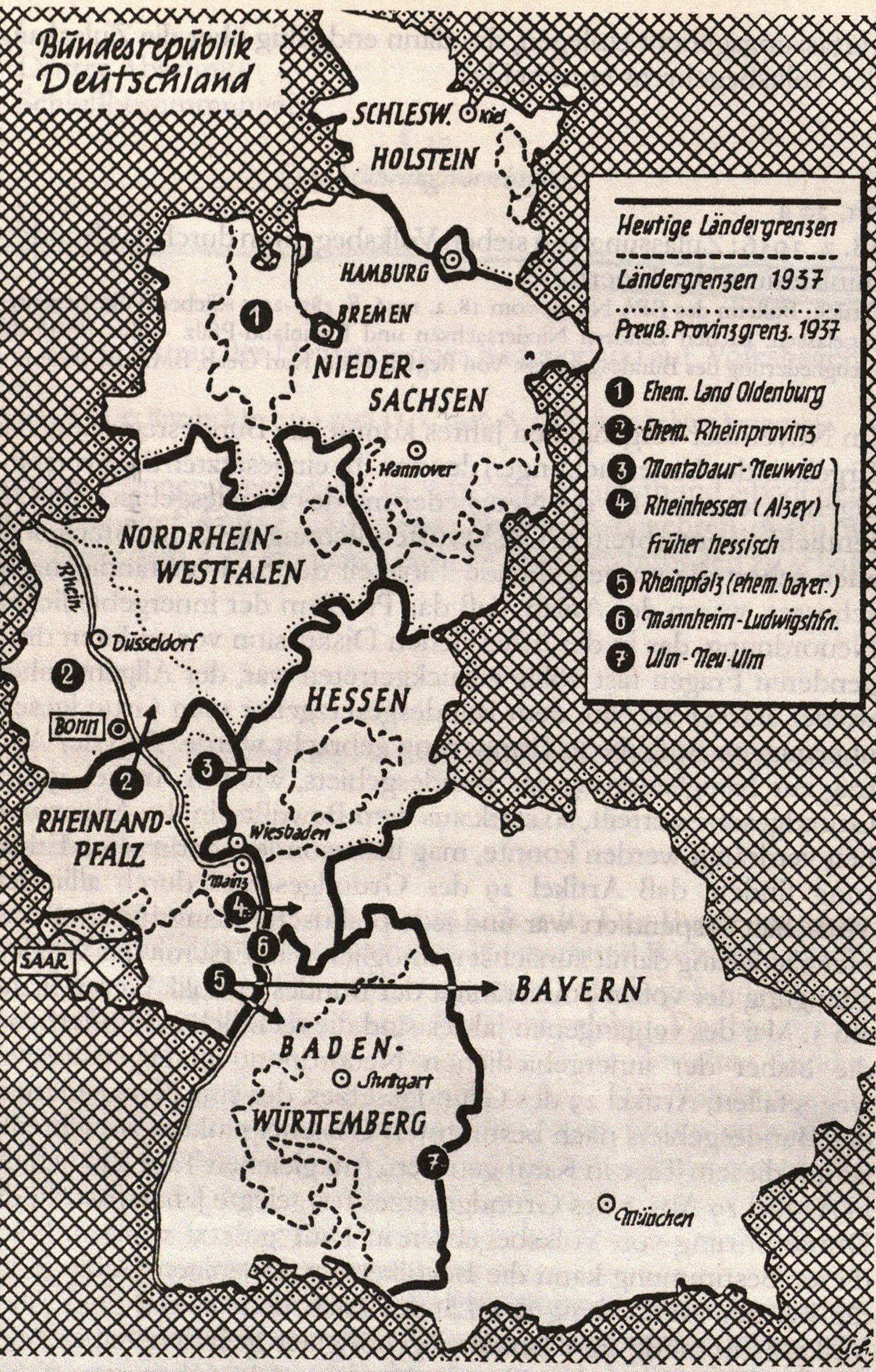
Territories which sought to change their statehood. Trier and Koblenz districts (2), Montabaur-Neuwied (3), Rheinhessen (4), Left-Rhenish Palatinate (5). Thick dotted lines are borders of former dynastic states and thin dotted lines are borders of former Prussian provinces
Even before the committee began its work, competing regionalists groups had formed in the Palatinate to advocate for different states. The committee subsequently travelled to the region in 1954, arriving at Neustadt, a town on the ‘Wine Street’ (Weinstraße), where they offered an audience to two competing regionalist societies. The first to present their case was the ‘Electoral Palatinate Society’ formed in 1949 to promote unification with a larger German Southwest state to eliminate a border that separated the Palatinate from the territories of the Electoral Palatinate in Heidelberg and Mannheim. 93 A society representative offered a cogent presentation on why a reunified Palatinate represented a common region. He began by noting how redrawing ‘inner-German’ borders democratically was unprecedented. 94 He continued by arguing that the two parts of the greater Palatinate had been in a common state from 1329 to 1797, after which its ‘middle point’ in Mannheim and Heidelberg had been ripped away, while the Congress of Vienna gave the parts of the Palatinate west of the Rhine to Bavaria. Palatinaters, he insisted, had hated their distant Bavarian overlords. He further argued that it was equally absurd to imagine that Rhinelanders and Palatinaters belonged in a common state. Inventing a new Stamm concept, he insisted that the Palatinaters were ‘Upper Rhine Franconians’. 95
Even within the Electoral Palatinate Society, however, divergences in regional cognitive maps could be found. While signature collection posters only depicted a re-unified Palatinate, several articles in their publications argued that they further shared regional cultural connections with the rest of the Southwest which they would be joining in a common state. 96 Others argued that they were simply part of an Upper-Rhine region which stretched down through Baden. This region, one article argued, was a land of wine and confessional tolerance and not the Bavarian land of beer, centralism, Catholicism, and conservativism. 97
The regionalist society ‘Bavaria and the Palatinate’, the second to present their case, had over 9000 members and supported reunification with Bavaria. 98 The society's case was bolstered by an aggressive campaign of support by the Bavarian state. Bavaria funnelled funds to the organization, founded a supporting sister institution in Bavaria, created mass propaganda, placed pressure on Konrad Adenauer, and established a new ‘Palatinate Committee’ in the Bavarian Parliament which toured the region, holding Heimat evenings. 99 Bavarian propaganda pushed bogus narratives about the Palatinate being integrally attached to Bavaria since the late Middle Ages. 100 The signature campaigns also saw the creation of the ‘Federation Rhineland-Palatinate’ – a group which argued for the extant state and the neighbouring Saarland as a common region, though many suspected it was financed by the state of Rhineland-Palatinate. Both signature collection efforts in the Palatinate, however, failed to reach the steep targets in the time allotted. The Bavarian side acquired signatures from 7.6 per cent of the voting population, compared to 9.3 per cent for unification with the Electoral Palatinate. 101
The remaining signature collection efforts succeeded, but also revealed divergences amongst co-regionalists. The efforts of the Heimat Society Hessen-Nassau to unify the town of Montabaur with Hessen represented a case in point. The territorial history of the areas had fluctuated at a dizzying pace. While it had been part of the Duchy of Nassau from 1806 to 1866, it subsequently became part of the Prussian Province of Hessen-Nassau until 1944. The new state of Hessen which they sought to join, however, was unprecedented and much larger than former states which bore the name. Members of the society diverged about whether they identified with the former Nassau Duchy, a larger Hessian regional idea, or both. The society's official platform pushed a narrower identification with Nassau, though some of its members also identified with a broader Hessian region. 102 As one member rhapsodized, the Hessian regional tradition had a ‘spirit of progress and tolerance’. 103 Yet, as one local postman asked at the society's founding meeting, was not the current state of Hessen just as unprecedented and artificial as Rhineland-Palatinate? 104
The efforts of denizens in Rheinhessen, the territories west of the Rhine around the historic towns of Mainz and Worms, demonstrated equal divergences. Luther Committee presentations, travel notes, and reports all noted the area's historic and cultural connections to other areas west of the Rhine. 105 The Rheinhessen Society, however, argued that their area was part of a greater Hessian region which belonged with the territories east of the Rhine. As one of their advertisements insisted: ‘We are Rhenish Hessians … Our name tells us to which state we belong. For us there is no question that we must again return to our Heimatland Hessen’. 106 The society denounced Rhineland-Palatinate as an ‘accidental state’ of French creation, a statement not without irony given that Rheinhessen had been drawn by the Congress of Vienna based on political calculations. 107 They ultimately acquired signatures from 20.3 per cent of voters, while those near Montabaur reached 25.4 per cent. 108
Regionalists from the wine-growing areas of the Middle Rhine around Trier and Koblenz collected signatures from 14.2 per cent for unifying with North Rhine Westphalia. 109 The ‘Union Rhineland’ Society attacked ideas of the Rhineland as only including the northern Rhine and drew on the memory of the Prussian Rhine Province, created in the early 1800s, which stretched along the Rhine and the drainage basin of the Saar and Mosel rivers. As the mayor of Trier argued, there could be ‘no Rhineland without Wineland’. 110 Prominent politicians had previously pushed the Rhine Province's restoration, including Adenauer, a Cologner who saw the region as a bridge between Germany and France. 111 Some Luther Committee members argued that regional cultures cut across the Rhine rather than following its flow, though others noted the strength of regional identification with the old Rhine Province. 112 The Union Rhineland also drew on physical geography, asking in one leaflet: ‘Where does all the water of the Saar and Mosel flow? To Cologne and Düsseldorf’. The southern areas of Koblenz and Trier, they insisted, shared a common cultural tradition and similar dialects with the North Rhine. 113
In the end, the Federal Government refused to schedule the legally-required referenda, though the state of Hessen brought a court case against Bonn for inaction. By 1961, the Constitutional Court declared that the Federal Government had flouted its constitutional obligation to redraw the federal map, but also dismissed the standing of federal states or regionalist societies to appeal. 114 Bonn would continue to resist until the new government of Willy Brandt in 1969, which saw scheduling the referenda as a legal obligation. The government revised Article 29 to set time limits on referenda scheduling, which meant they would have to be held by the mid-1970s. 115 By the 1960s and 1970s, however, the culture of West German federalism had shifted. As the legal scholar Helmut Quartisch argued in 1968, the federal states had increasingly become ‘entities of utility’ rather than ‘entities of feeling’. 116 This was well-reflected in the ‘Ernst Kommission’, a new committee which set out its own proposals in 1973 for redrawing state borders. The committee jettisoned consideration of culture and regional belonging as a secondary factor, proposing simply to create larger states based on technocratic and administrative considerations. 117 While their work is certainly interesting in terms of the broader history of West German federalism, these subsequent debates tell us relatively little about cognitive maps of regional belonging, which had proven a central question in earlier years.
Despite waning interest, the referenda would finally be held in 1975. In Rhineland-Palatinate, 33.2 per cent in the Koblenz and Trier districts voted for reunification with the Rhineland, while 24.7 per cent in Rheinhessen and 30.9 per cent in Montabaur voted for joining Hessen. 118 The votes in Oldenburg and Schaumburg-Lippe, however, became proxy votes for expressing anger against the Lower Saxon government's recent series of communal reforms which consolidated local governments against the will of many residents. 119 Around 80 per cent of participants in both referenda voted against Lower Saxony, though this was less than 40 per cent of the total eligible voting population. 120 Such anger at communal reforms in states throughout the Federal Republic had become more of a source of public ire than earlier concerns about redrawing federal states according to regional feeling. 121 The Federal Government, however, responded to the referenda by simply unbinding itself from earlier constitutional obligations. It revised Article 29 to read that the states ‘can’ be reshaped according to the outlined criteria. 122
The prospect of redrawing the map would again raise its head with national reunification in 1990. Few, however, suggested redrawing the East German states based on regional belonging. Some West German experts in the 1950s, anticipating an earlier reunification, had already considered how the states of East Germany could be redrawn according to regional belonging. The results, however, revealed the same points of conflict and ambiguity about where such regions could be found in geographic space. 123 In the case of Thuringia, such ambiguities could already be seen in the Weimar-era efforts to unify the region, with divergences between identification with Prussia and Thuringia in the north and Bavaria and Thuringia in places to the South like Coburg. 124
While regional belonging did not represent the main factor in thinking about the recreation of East German states in 1990, the moment provided ample evidence of divergent regional imaginings. Under pressure to achieve rapid national reunification, the newly elected Volkskammer rushed to restore the East German states abolished by the Soviets in 1952. The importance of speed meant they could only approximately recreate them by hobbling together the extant administrative districts (Bezirke) whose borders often did not align with those of the former states. Informational referenda were held in counties (Kreise) who found themselves in new states, whose councils were empowered to vote to join neighbouring states. The referenda revealed divergences in regional belonging along all the borders of the five recreated states of Mecklenburg-Vorpommern, Saxony, Saxony-Anhalt, Brandenburg, and Thuringia. 125 Beyond border areas, other divergences could easily be found. Lusatians, for example, diverged between those who identified with Saxony and those who argued for a separate Lusatian regional idea rooted in the area's Slavic Sorbian histories. 126 The loss of parts of former regions along the new Polish border and earlier German divisions also created new ambiguities. Areas like the Eichsfeld had been split in half by the iron curtain, while regions like Pomerania had been cut in half along the new border with Poland. Many West Pomeranians, however, still asserted a Pomeranian regional identity and some believed they should have their own state. In the town of Görlitz, the last speck of the Silesian region still in Germany, many Görlitzer held to a Silesian regional idea despite being part of Saxony. 127 More practical considerations, however, proved more decisive in the shaping of the ‘new’ federal states.
Conclusion
Intense West German efforts to find the borders of regional belonging revealed how regions were remarkably able to hold diverging cognitive maps of community in suspension. Post-war politicians, spatial planers, geographers, and other scholars uncovered tremendous divergences. Dialect spaces, confessional identities, conflicting maps of past territorial states, diverse notions of ‘Stamm’, orientation to urban centres, and the historic force of physical geography could all influence imaginings of region but failed to create commonly agreed upon maps. These patterns ultimately revealed how the dynamics of imaginings of modern regions and modern nations in territorial space were both different. The modern idea that national communities represented the ultimate source of political sovereignty underpinned ever growing efforts to discipline and fix the geographic contours of the nation to achieve an exact overlap between national decision-space and identity-space. While regional states undertook their own state- and identity-building projects, their ability to force a consensus on imaginings of regional community proved more limited.
The German lands offer us examples of such divergent imaginings in a place with deep federalist histories. Studies of historically centralist countries would certainly offer an interesting cross-comparison. Given the role of sub-national decision-spaces in shaping regional identities, it would seem likely that cognitive maps of regions would be even less defined in these cases. Some evidence confirms this suspicion. In Italy, which did not have the same federalist traditions, early post-war efforts to introduce new federalist structures failed in part given conflicts over what territories constituted ‘regions’. 128 While orientation towards cities often overshadowed a sense of region in the Italian tradition, a ‘city principle’, it would appear, offered no more conclusive answers than it did in the West German case. In the English case, proposals to introduce new federalist structures have also continually failed to answer intractable questions about what areas represent coherent English ‘regions’. 129 Ambiguities can also be seen in Eastern European contexts, with one recent study of regional identity in the traditionally-centralist Czech lands demonstrating how the redrawing of provincial borders in the late twentieth century has informed divergent generational imaginings of regional belonging. 130
Federalist states provide similar examples, and Spain, with its hybrid constitutional structures, offers a case in point. While Spain has seen more examples of separatism, it too has confronted a lack of consensus on where its communities lie in geographic space. Territorial imaginings of Greater Catalonian or Basque nations, for example, have conflicted with narrower Valencian and Navarrese regional ideas. Identifications with the latter two have often aligned with a rejection of separatism. 131 Very small groups of separatists in West Germany, as we have seen, also confronted divergent cognitive maps. Perhaps because separatism did not represent a true threat in the West German case, we do not find equivalent examples of support or opposition to separatism informing the appeal of different maps.
On the whole, the efforts to redraw the federalist map in early West Germany provide insight into the dynamics of federalist reform – whether in Germany or elsewhere – and the conflicting territorial imaginings of regional community which reforms will often have to confront. Most importantly, the history of these efforts sheds light on how forms of community beneath the nation state have been cognitively mapped. Rather than taking modern nations as representative, more attention is needed to how cognitive maps of modern territorial communities have been forged in contexts where such communities did not lay claims to absolute political sovereignty. Regions, which laid claim at most to partial forms of sovereignty, offer a unique lens into these processes. If, as Charles Maier has argued, the late twentieth century marked the beginning of a slow decline of a ‘territorial age’, defined by absolute demands for an overlap between ‘decision space’ and ‘identity space’, it would seem all the more important to consider the potential consequences such a divergence could have on geographic imaginings of belonging. 132