
Abstract
This article explores the co-production of wind energy resources and UK maritime territories in the North Sea. It shows how endeavors to map wind for energy are shaped by specific spatial imaginations, which are in turn making it possible for the UK to advance sovereign claims over volumetric spaces offshore. This follows a long history of efforts to study and map wind movements alongside significant chapters of colonialism, imperialism, and territorial dispossession. The practices involved in the transformation of atmospheric circulations into territorial claims center on what I call ventography: the systematic study and cartographic representation of wind in relation to political boundaries, a project which is shaped by, and subsequently enrolled in, territorialization, sovereign performances, and border regimes. In this vein, the intangible nature of wind, often thought to be beyond the grasp of spatial politics, is being transformed into a resource that is coming to play a role in the production and reconfiguration of space in altogether new ways. Through a focus on the UK’s attempts to transmute wind power into territorial power, this article traces how ventography is reshaping the scales and configurations of contemporary political geographies.
Introduction: ventography and the spatial politics of wind
The North Sea has long been a vital hub for oil and gas production for the United Kingdom. Since the discovery of significant hydrocarbon reserves in the 1960s, the British sector of the North Sea has been a cornerstone of the nation's energy industry. Over the last 50 years, advanced drilling technologies and offshore platforms have enabled the extraction of substantial quantities of oil and gas from the Sea's subterranean depths. However, while it is debated how much oil and gas remains, it is clear that North Sea reserves have already passed their peak. Some estimates suggest that there are only between 10 and 20 years’ worth of fossil fuel stores remaining (Macdonell, 2023). While not appearing to slow down offshore oil and gas production, the UK and other North Sea petrostates 1 have at the same time increasingly invested in alternative energy experiments (e.g., Watts, 2018), aiming to transform the North Sea into a renewable energy hub. These projects include plans to repurpose oil platforms and even create artificial islands for wind, solar and wave energy production. Moreover, the entire maritime region, once synonymous with fossil fuel extraction, is now undergoing a large-scale transformation with the installation of vast offshore wind farms and electricity interconnection projects. Currently, the UK is a global leader in offshore wind development, producing approximately 20 percent of global offshore wind capacity. 2 This island nation will soon be home to the world’s largest offshore wind farm and continues to expand wind development into new maritime territories. 3
Although represented in some arenas as a seamless transition from one kind of energy extraction to another, this article contends that the widespread development of renewable energy is a useful site to explore both the extent to which fossil fuel extraction has shaped the contours of contemporary political geographies, as well as how political space is reconfigured through the cultivation of new energy resources. In this article, I argue that the contemporary study of wind as a source of energy is not merely a neutral project to facilitate energy transitions, but is deeply intertwined with historically-specific conceptions of territory and the spatial configurations of empire. Specifically, this article focuses on the observation, measurement, and mapping of wind in the context of the energy transition, and the spatial imaginaries that shape this work in the United Kingdom. It traces how wind – through its cartographic representation and imagined relationship to political space – comes to be grounded and claimed as both a national and ‘natural’ resource. It further demonstrates how national wind resources are co-produced alongside conceptions of territory, which are in turn making it possible for the UK to advance sovereign claims over new maritime spaces in the North Sea. More broadly, this article illustrates how states around the world are nationalizing wind resources in offshore areas through wind maps, forwarding claims to the very edges of continental shelves as well as contested archipelagic waters, extending de facto national sovereignty over sea- and airspaces that has previously been limited.
The practices involved in this transformation of atmospheric circulations into territorial claims center on what I call ventography 4 : the systematic study and cartographic representation of wind in reference to political boundaries, a project which is shaped by, and subsequently enrolled in, the production of territory, sovereign performances, and bordering regimes. Ventographic practices work to ground what are inherently transboundary atmospheric phenomena to specific locations, thereby naturalizing them as a part of evolving visions of territory. Conceptually, ventography not only challenges the seeming ‘objectivity’ or ‘placelessness’ of the practices involved in the study and representation of atmospheric currents, but adds a further layer of politicization, drawing attention to how certain ways of imagining wind in relation to political space both forward arguments about space and in turn shape how wind is perceived and engaged. This concept differs from the larger framework of meteorology (the broader science that encompasses the study of all aspects of the atmosphere) under which studies of wind are typically categorized, as well as the more narrow ‘aeropolitics’ (Nieuwenhuis, 2016) that has focused on how atmospheric spaces have become the sites of different kinds of politics. Rather, ventography focuses explicit attention on wind, and on the practices that inscribe atmospheric movements with political significance and territorial imaginings. In separating out engagements with wind, I do not suggest that the practices involved in meteorological knowledge production or aeropolitics are not themselves imbued with certain spatial imaginations or are engaged in territorial agendas. However, these broader classifications do not allow us to tease out the specific materialities of wind and its particular spatial politics.
I draw on work that has explored the specificities of different kinds of resource materialities, for instance, in identifying how the materialities of oil or water produce distinctive spatial politics (Bakker and Bridge, 2006; Mitchell, 2011). This follows a suite of scholarship in geography and anthropology that has challenged conceptions of ‘natural’ resources as inherently existing in specific geographic areas, demonstrating instead how resources are socially constructed and produced within economic and political contexts, fields of power, and temporal frameworks (e.g., Bakker and Bridge, 2006; Ferry and Limbert, 2008; Li, 2014; Richardson and Weszkalnys, 2014). While socially produced, attention to matter and materiality highlight how biophysical properties of various ‘natural’ resources ‘make a difference in the way social relations unfold’ not as ‘pregiven substrates that variably enable and constrain social actions’ (Bakker and Bridge, 2006: 18) but as historically-specific products of certain ways of knowing, seeing, and doing. It is likely that attention to other atmospheric phenomena may reveal distinctive scales and conceptions of political space that differ from engagements with wind (i.e., rain, solar irradiation, clouds). Moreover, as I demonstrate in this article, wind resources have different kinds of spatial politics than other energy resources like oil and gas. As such, distinguishing the practices of ventography from meteorology and aeropolitics opens up a site of inquiry that more systematically interrogates the intersections between resource-making, materiality, and contemporary political geographies.
The arguments I advance in this article depart from conventional characterizations of wind as an elusive force that cannot be bound or owned, a view that permeates approaches to wind energy. This widespread perspective is advanced, for example, by Finserås et al., (2024: 3) in stating that, wind does not have an adherence to artificial, jurisdictional boundaries. […] Due to its natural features, it is therefore fungible, intangible and not exclusive. Wind energy, like solar energy, may be described as a common resource; it is incapable of physical possession or to be rendered excludable, either by way of proprietary ownership or by sovereign claims.
This is reiterated by Degani et al. (2020: 11), who argue that ‘unlike oil, gas or coal, no one “owns” wind.’ While for many, wind, ‘refuses to be represented – only becoming visible through its effects on other beings and other things’ (Howe, 2015: 203), this article aims to bring into focus the practices that do represent wind, as well as how these representations are engaged to produce wind as a form of property that can be grounded to specific territories.
In the UK, the recent expansion of wind mapping follows a long history of British attempts to study and map wind movements alongside significant chapters of colonialism, imperialism, and territorial dispossession. Observations and cartographic representations of wind have structured and made possible the trans-oceanic movements that have shaped and re-shaped the contemporary political geographies of our world (Bankoff, 2017). Early European maritime trade, ‘New World’ economies, settler colonialism, transatlantic slavery, and imperial circuits were not only made possible through efforts to know and leverage wind as a source of energy for sailing, but the cartographic practices of mapping wind both emerged from and helped produce a vision of space – of land, sea, skies – as territory (cf. Grossman, 2023). Territory, as a historically-specific conception of space that emerged alongside colonial and imperial projects, is dependent on ways of measuring and mapping that make it possible to codify territorial control. In this vein, territorialization is a way of conceiving of geographic space as something that can be owned, controlled, and administered (Elden, 2013b; Storey, 2001). In the UK, the mapping of wind has long been engaged in the co-production of both territory as well as ideas about its rightful use, possession, and appropriation. The formal organization of meteorology as a discipline emerged as an integral part of territorial expansion by European powers (much like anthropology and geography) (Burton, 1986; Walker, 2011), and the study of atmospheric circulations, ‘presented claims about geographical control that connected science firmly with the enterprises of an imperial state’ (Anderson, 2005: 243).
At the same time, the emergence of national and imperial weather geographies was not solely driven by the intentions of elite actors seeking to gain economic and political power; rather, it emerged from a diverse array of individual observations, practices, and situated projects that laid the foundations for the production of weather knowledge. In this vein, the work required to produce the daily observations needed to generate forecasts and wind maps was beyond the scope of state power alone. Instead, the British Meteorological Office in London relied on an expansive network of farmers, fishers, pub owners, shepherds, boat deckhands, colonial settlers, and merchants to record their perceptions of weather on a regular basis. 5 As a result, rural, coastal, and colonial sites became central nodes in the expanding network of weather knowledge, remaking ‘weather’– once imagined to belong primarily to specific regions (Jankovic, 2000) – into imagined national and even transnational geographies (Slonosky, 2018) through cartographic representations. By capturing wind data from disparate regions and incorporating it into a unified map, these observations did more than just provide meteorological insights; they contributed to the construction of the territorial identity of the British Empire (cf. Grossman, 2023; Slonosky, 2018). Thus, weather observation and mapping was a key technology that emerged from and served multiple colonial interests beyond state administrative agendas (Golinski, 2007; Williamson, 2015).
These historical entanglements between the production of territory and weather observations have shaped the practices of contemporary meteorological knowledge production, which continues to be entangled in uneven geographies of power and imperial expansions (Wright and Tofa, 2021). As the global focus on renewable energy development continues to grow, there has been a significant increase in attention directed towards wind for its capacity to generate electricity. In this context, new efforts to map and know wind have emerged en force. At the same time, it is important that these projects are considered alongside longer histories of colonial and imperial engagements with wind, and how those histories have shaped the current infrastructures and geographies of atmospheric knowledge production.
Below, I demonstrate how wind is both naturalized and nationalized as a resource through specific spatial imaginaries and cartographic representations. I then demonstrate how the production of wind resources through ventographic practices are coming to play a key role in the UK’s aspirations to extend state territory and sovereign claims into entirely new spatial domains, marking a shift in the evolving dynamics of territorialization and maritime governance in the North Sea. However, the state in this analysis is not an autonomous actor pursuing its interests in a coherent way (Agnew and Kuus, 2008). Rather, the state is constituted and continuously enacted through a range of practices and processes (Trouillot, 2001), in which, I argue, ventography plays a role. At the same time, just as the weather knowledge that made it possible to envision the geographies of the British Empire relied on a diverse array of actors, so too does the imagination of national wind resources by non-state actors contribute to the contemporary enactment of the state. Before turning to a discussion of these projects to know and map wind, I first provide a brief overview of the theoretical and empirical bases of this article.
Territory and volumetric sovereignty
The idea of a nation-state as a fixed territory exercising absolute sovereign power within its geographic boundaries – which has remained a powerful core assumption of international relations – has become increasingly difficult to defend. Far from a world of equally sovereign and territorially delimited states, anthropologists and geographers have challenged presumptions about the alignment between territory, sovereignty, and state power, while also tracing how ideas about the spatial arrangements of political authority are enacted, contested, and reconfigured. In this article, I follow political geographers and anthropologists who have come to see sovereignty as a fragmented performance linked to a series of material and discursive practices (e.g., Agnew and Kuus, 2008; Edkins and Pin-Fat, 1999; Sidaway, 2003). As a historically specific and ongoing project that emerged from colonial and imperial projects (Bonilla, 2017), sovereignty is ‘a tentative and always emergent form of authority grounded in violence’ (Hansen and Stepputat, 2006: 16.3). Moreover, sovereignty is not only constructed and contingent, but it is also situated within uneven global flows (Emel et al., 2011), extending the geographies of sovereignty necessarily outside the imagined boundaries of states (Sidaway, 2003). In this vein, sovereignty is more often performed through attempts to control flows and networks rather than an exercise of complete power over national blocks of space (Agnew and Kuus, 2008). Ong’s concept of ‘graduated sovereignty’ (2006) is particularly evocative of the uneven distribution of sovereign power across territories, such as in maritime zones, which I expand on below (cf. Havice, 2018).
Moreover, the ‘volumetric turn’ (Billé, 2020b; Squire and Dodds, 2020) in political geography has brought attention to the ‘three-dimensional realms’ (Billé, 2020a: 4) of sovereign claims, triggered in part by Elden’s (2013a) argument for rethinking geography in terms of volumes rather than areas. Attention to volume has challenged representations of politicized space as horizontal, terrestrial, and flat, instead inviting examinations of how sovereign claims are extended vertically into subterranean, sea, ocean, and atmospheric spaces. With the development of new technologies that make extraction possible in areas previously beyond the reach of state and capital (Billé, 2020b) maritime areas have become the frontier of state territorial expansions (Østhagen, 2021). As a result, roughly half of all maritime boundaries around the world are in dispute (Østhagen, 2020, 2021; Schofield et al., 2022). This has emerged as part of what Ong (2020) calls ‘blue territorialization,’ in reference to the more recent production of sea, ocean, and sky zones over which states are attempting to flex their sovereign ambitions. Attention to volume has similarly helped draw out the specificities of the entangled relationship between the contemporary formation of the nation-state and the environmental sciences that make it possible to conceive of space as volume in the first place (A. H. Li, 2024).
As such, the production of the territorial state has increasingly come to be seen as a series of ongoing (and unstable) encounters between political regimes, scientific knowledge, technology, and socionatural entanglements (e.g., Braun, 2000; Carroll, 2006; Scaramelli, 2021). Environmental knowledge production and the calculative rationalities that enable the quantification of landscapes, species, and ‘natural’ resources to be measured as forms of property that can be claimed, managed, and disposed of are directly implicated in the production of the nation-state. Resource-making and resource imaginaries have played a significant role in the production of political geographies and spatial imaginaries (e.g., Bridge, 2014; M. Huber, 2019; Koch and Perreault, 2019; Wainwright, 2005), and resource-making is itself a project of territorialization (Bridge, 2010) that sustains empire (Blair, 2023). In this sense, ‘far from being merely incidental features of national identity,’ Koch and Perreault note, ‘resources are fundamentally constitutive of the material and ideological nature of nations and states’ (2019: 616). The production and management of ‘natural’ resources is similarly a frontier for the contestation and performance of state sovereignty (Bigger and Neimark, 2017; Havice, 2018). As such, attempts to map resources and environments are useful sites of inquiry into the formation and reconfiguration of contemporary political geographies.
These dynamics are exemplified par excellence by the petro-state, where a socially and politically produced nature has become central to the imagination of the nation, such that nation and nature appear inseparable (Coronil, 1997). This process not only involves the nationalization of resources, but also justifies territorial expansions and sovereign claims into new spaces through various resource imaginaries (Fry and Delgado, 2018). The production and exploitation of fossil fuel resources have been one of the major catalysts behind the production of borders, territory, and the expansion of volumetric sovereignty over the last century (e.g., Bulkan, 2021; Schritt and Andrea, 2018). The discovery of oil and gas deposits, and efforts to extract them, introduced novel ways of envisioning territoriality that extended into subterranean spaces (Billé, 2020a). Later, the identification of fossil fuels below ocean and sea floors led to new conceptions of resource geographies that made it possible for states to extend claims to sovereignty over areas beyond territorial waters (namely, through the notion of the continental shelf, which I expand on below) (Stevenson and Oxman, 1994). Given their specific spatial focus on the production of, and claims over, subterranean territory (Appel et al., 2015), we might even name these processes ‘petro-territorialization.’ 6 As opposed to oil and gas, I show how the more recent interest in mapping wind has made it possible to reconfigure national space as consisting of much larger volumes of water and air, necessarily working to expand the territories and limits of sovereign claims previously shaped by fossil fuel resource imaginaries. While the geographies of volumetric sovereignty in maritime spaces have been focused on the subterranean (where hydrocarbons are imagined to be present), I show how attention has now turned to the airspace above.
As such, this article adds to more recent work (e.g., A. H. Li, 2024) that focuses closer attention on how specific forms of environmental knowledge make it possible to produce territory as voluminous. As Li notes, we do not simply see the voluminousness of a territory’s materiality through our own bodily or cultural registers, but also through a socionatural assemblage that also involves technological, infrastructural, and scientific apparatuses which bring specific material properties into being. (2024: 3)
It is thus not only wind’s materiality that comes to shape how it is engaged and known, but that its materiality is similarly produced and represented in specific ways through wind maps. Moreover, the nation as a ‘reference grid’ to measure and map environments and biophysical processes (e.g., Scott, 1998; Whitehead, 2009) does not just provide a framework for observation and knowledge production, but itself works to invoke and reinscribe the idea of the nation-state. Yet, in recent discussions of wind and solar resource mapping (e.g., Avila, 2018; Castán Broto and Baker, 2018; McCarthy and Thatcher, 2019) there has been a tendency to focus on the state in functional terms, as an actor that advances projects of capital accumulation rather than a focus on how the state itself is constituted through these projects.
Additionally, several of these treatments of energy resource mapping assume that such representations merely ‘identify’ resources for extraction. Yet, far from objective representations, maps are propositions (Kitchin et al., 2009; Wood and Fels, 1992). They are ‘performative, participatory and political’ (Crampton, 2001), forwarding claims, advancing arguments, and betraying specific ideologies (Harley, 1988). Resource maps do not in and of themselves identify existing deposits of ‘resources,’ but instead come to play various roles in structuring relationships, technologies, and forms of knowledge that contribute to the conditions of possibility for resource-making. As such, resource maps do not just claim to reflect reality, but actively shape it (Mano et al., 2011). It is thus the premise of this article that the assertions embedded in wind maps require further explication: what kinds of arguments do resource maps advance beyond claiming to ‘identify’ resources? How do they envision political boundaries? What kinds of volumetric space do they produce? Why and how is the state identified as the rightful agent who should map and administer these resources? What other kinds of claims are rendered invisible (such as Indigenous or communal ownership)?
Here, I avoid assumptions that the national scale is the obvious spatial referent for studying and mapping atmospheric processes. Rather, I draw on recent work that has brought the question of how such scales are produced and acted on through engagements with environments and resources (Harris and Alatout, 2010; Perreault and Valdivia, 2010). Following from the observation that the cultivation of new forms of energy involves the production of space in altogether new ways (Baptista, 2018; M. T. Huber and McCarthy, 2017; Zimmerer, 2011) this article explores how space is constituted and mobilized politically in and through efforts to know and map wind. Finally, by tracing how the UK engages ventographic practices to claim territory and perform sovereignty, I do not suggest that these projects are always successful. The materialities of ‘volume’ present unique challenges (Squire and Dodds, 2020), as well as the unexpected, fluid, and dynamic qualities of environmental forces (Steinberg and Peters, 2015) that are difficult to control and police. At the same time, while such attempts may be unevenly effective, they are nonetheless consequential in important ways.
Analytical approach
This article draws on over two years of ethnographic research in the UK renewable energy industry. During this time, I worked as an unpaid intern for a multinational renewable energy developer (which I call TEC, “The Energy Company”), focusing on site identification and resource development. Studying the practices of energy companies presents challenges due to the restricted and often secretive nature of the industry. Access to company operations, decision-makers, and everyday practices is closely guarded, and the bulk of employees’ work is often not accessible to participant observation (cf. Coleman, 2008; Gusterson, 1996; Müftüoglu et al., 2018; Nader, 2010). This lack of access can often extend to relationships and engagements between energy company employees and actors outside the company, for instance, relationships and arrangements with state administrative offices and utility companies. Yet, the practices involved in developing renewable energy sites are often based on unwritten rules and shaped by unspoken power dynamics, making ethnographic research and participant observation some of the only ways to understand certain aspects of the work to develop new forms of energy. Ethnographic research is thus a valuable tool for tracing the processes and relations that cannot be grasped through short-term engagements or through documentary sources alone. By taking on an internship at one multinational energy company, I was able to both observe and participate in these practices firsthand.
During this time, I was trained to read, interpret, and produce various kinds of maps used in the developing of renewable energy sites, including resource maps, infrastructural maps, and maps representing various governance regimes (including conservation zones). In my engagement with wind resource mapping in particular, I found that it went beyond a mere documentation of physical attributes or atmospheric circulations. Rather, these maps became powerful tools for communicating ideologies, claims, and vested interests related to energy production and territory. Engaging with, and sometimes even producing, energy resource maps myself alongside co-workers provided insight into the different kinds of assumptions and visions of space that were informing this work. By immersing myself in the process of map creation, I gained firsthand insights into the various political and economic projects – as well as everyday practices and assumptions – that structured engagements with wind.
In tracing how these maps were used in practice in the energy industry, I was able to identify initial connections between wind resource maps and UK territorial ambitions. I then assembled and closely ‘read’ maps of wind resources produced by industry, academia, and state offices, paying attention to how these visualizations have changed over time, which allowed me to identify trends, shifts, and advancements in the conceptualization of wind resources. I similarly tracked the narratives they forward about the utilization and governance of the newly imagined resource spaces they purportedly represent. In formulating this analysis, I further draw on documentary sources including news articles, academic papers, industry reports, and legislation to identify the spatial arrangements that these maps have made possible. I similarly document the relationships between wind maps and new legal instruments that have been central to expanding sovereign claims over newly produced maritime territories, which in turn facilitates the work of renewable energy companies to develop renewable energy sites. This approach to 'reading' wind resource maps combined with ethnographic research produced a nuanced understanding of the spatial politics of wind, to which I now turn.
Wind maps and territorial imaginations
Melissa, 7 an engineer hailing from the Scottish Highlands, was one of my co-workers at TEC and predominantly focused on offshore wind development. Her workspace in the corner of the office was messy, although there seemed to be a certain logic to its organization, especially when she would reach deliberately for a chart tucked under a pile of folders, knowing exactly where to look. This was an ordinary day for her, collecting data from disparate sources to try to map out ideal locations for wind farms in British waters in the North Sea. As she flipped through visualizations on her computer, she paused at a simulation of wind behavior in one particular area, which was circumscribed by lines demarcating the UK’s territorial waters, its Exclusive Economic Zone (EEZ), and the continental shelf (Figure 1), each zone indicating areas where the UK exercises varying levels of sovereignty. The wind's pattern emerged on Melissa’s screen, displayed in real-time – threads of air currents, each one linked to a specific spot on a geographic map, colored by wind speed intensity. Despite the fact that wind is a global phenomenon, the wind visualized on Melissa’s screen stopped abruptly at the UK’s outer maritime border, where the territory of neighboring countries began. It was only after several months of working in the energy industry that it occurred to me that this was an odd way to think about wind. One day I asked Melissa why the wind stopped so suddenly, wondering if perhaps the company simply did not have information about the larger transnational paths the wind took. Melissa shrugged, ‘if it’s across the border, it’s not British wind, so we’re not really interested.’
These specific visions of wind and its relationship to space were highly normalized in the energy industry, so much so that it had taken me months to recognize and deconstruct the idea that wind should normally stop at national borders. In the energy industry, wind was apprehended not as a global or regional atmospheric system, but as a resource belonging to the UK. We did not, however, use national-level resource maps for identifying pre-existing ‘wind resources.’ In fact, most wind farms are being developed in areas determined to have relatively minimal wind potential by these maps (see Figure 2). Rather, these specific visualizations of ‘national’ resources were used in the energy industry to identify and invoke the political and legal regimes that made large-scale offshore wind development possible. Until fairly recently, most energy companies were reluctant to site wind farms outside of territorial waters (roughly 12 nautical miles from the shoreline). 8 This was largely because of ambiguity regarding the right of the state to approve wind farms outside of territorial waters in the EEZ, as well as whether or not domestic law would apply to (and protect) wind development in these areas. As I expand on below, the UK government did not technically ‘own’ maritime space beyond its territorial waters; under international law, states only retain rights to resources in subterranean spaces and the water column in the EEZ, rights that coexist with some public access (Andreone, 2015). For this reason, it was debated whether or not the UK could in fact lease space in the EEZ to energy companies for the extraction of resources above the water (K. N. Scott, 2006). However, the geographies of wind energy production, and the territorial and legal regimes shaping these new energy regimes, are being reconfigured.
As I show in detail below, national resource maps have made it possible to conceive of both wind and maritime space as national territory that could be leased as property with exclusive possession to corporations for energy extraction, as well as the extension of legal regimes over these territories in order to protect company investments. This vision of resources and territories overwrites other kinds of claims, such as communal wind ownership (e.g., Wade and Ellis, 2022), and instead champions state ownership and corporate extraction. When applying for permits or lobbying for political support for the development of wind farms in maritime areas, industry actors would routinely leverage these maps as political tools for reiterating state ownership of wind and territory (for the benefit of the energy industry). While not depictions of inherently existing resources, national wind maps advance a ‘resource ontology’ (Nadaï and Labussière, 2010) that produces wind as property, similarly claiming maritime space as state territory in the process.
These national imaginaries of wind resources are not only a result of the more recent concerns of a growing renewable energy industry, however. The interest in mapping wind as a national resource exploded in the 1970s as a result of both Cold War competition as well as the 1970s energy crises. 9 From the outset, these studies focused on country-level wind analyses in an attempt to understand the potential for wind energy, to both reduce vulnerability to energy supply disruptions and diversify power sources. What is remarkable about the cartographic mapping of wind resources over the past 50 years is that the wind is consistently imagined to abruptly stop at national borders (e.g., Figures 3 and 4). In the 2000s, advancements in wind energy technology coupled with increasing clean energy goals led to an international expansion of wind mapping efforts, and just about every country in the world can now claim ‘national wind resources.’
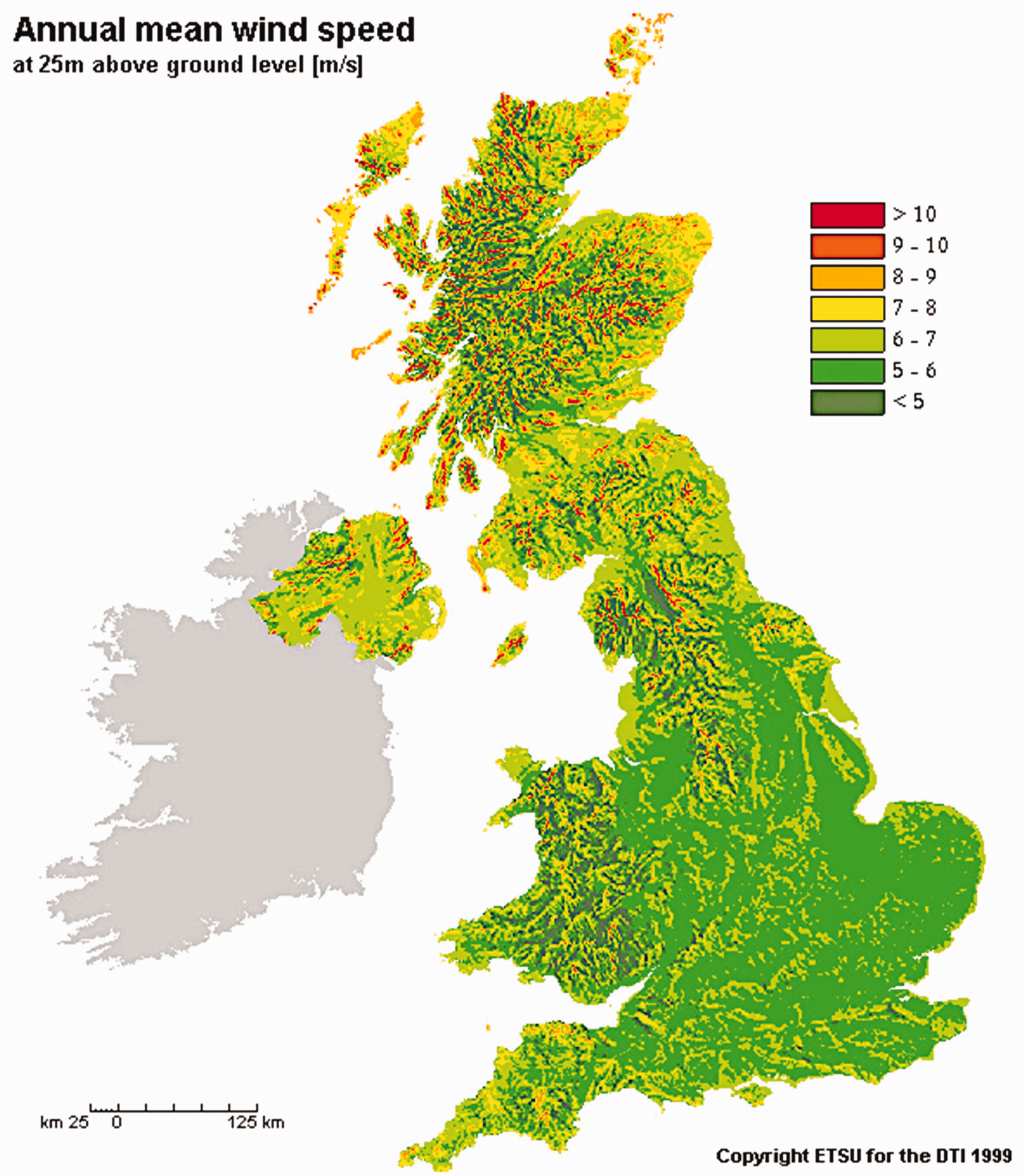
Wind resources are here imagined as part of national territories, ceasing at national borders, despite wind’s transboundary and global characteristics. In this rendition, British national wind extends to UK territory in Northern Ireland (to the left). © The Energy Technology Support Unit.
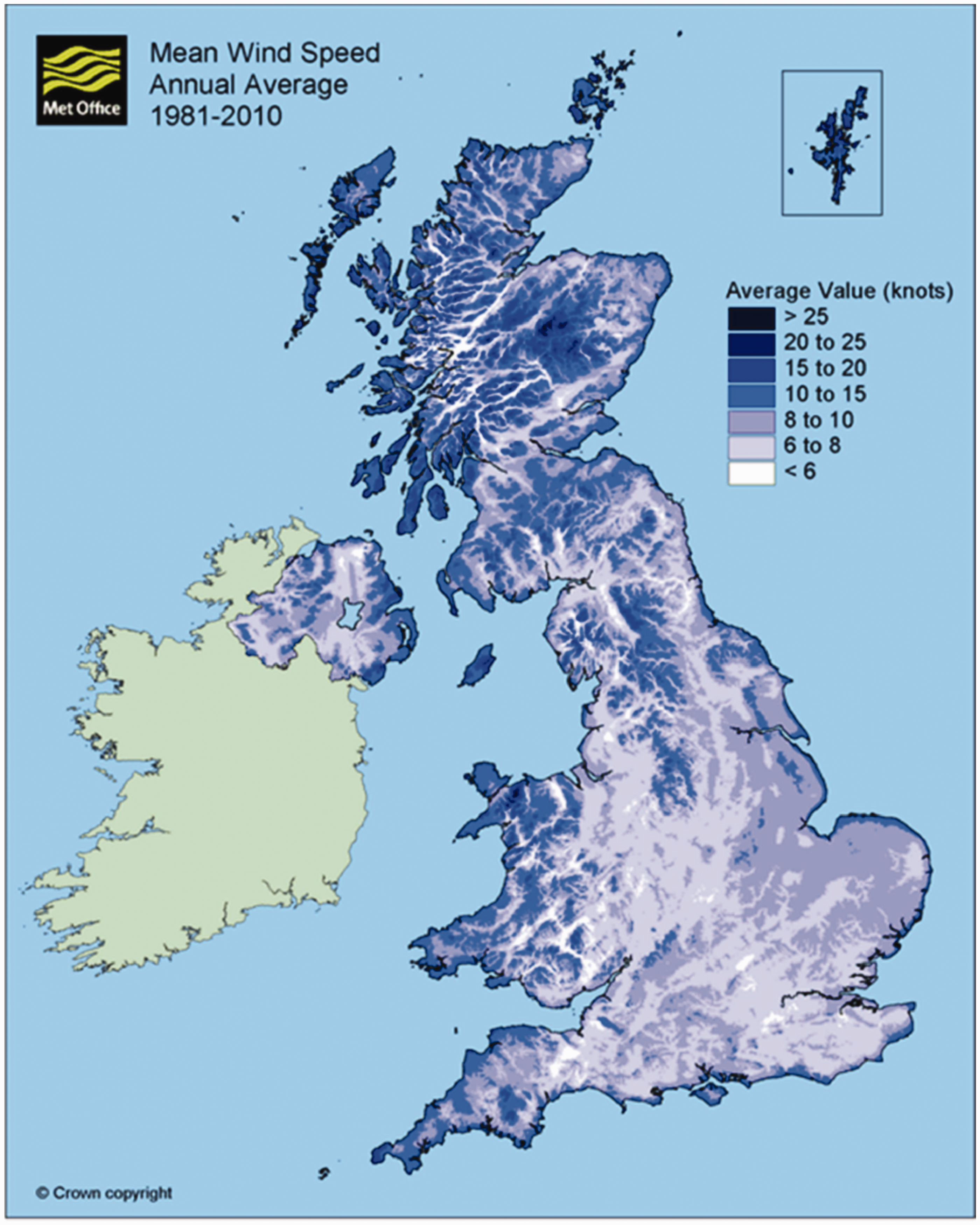
A map of UK wind resources produced by the UK Meteorological Office. © The Crown Estate.
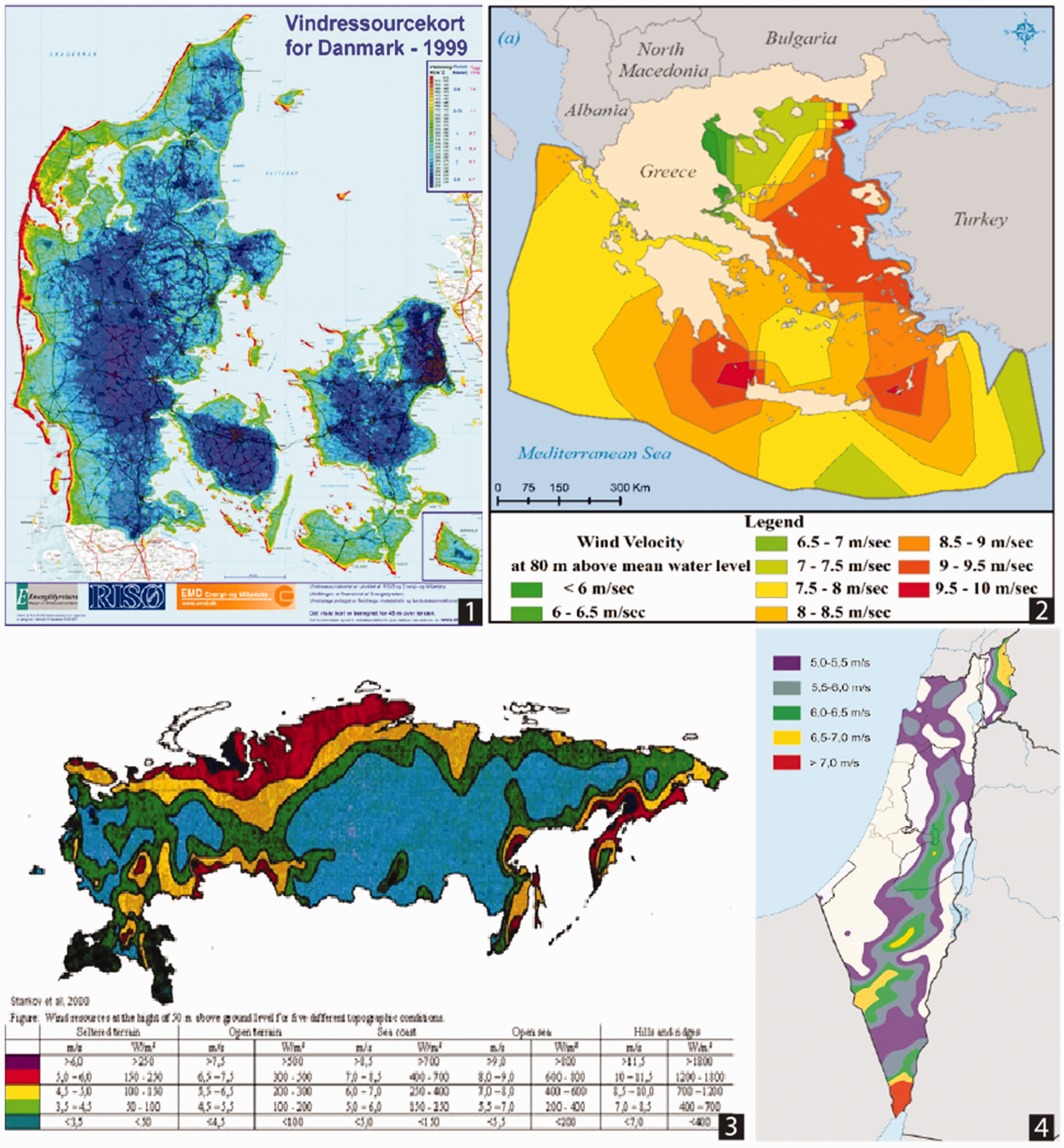
The naturalization and nationalization of wind resources through cartographic representations of atmospheric movements. Wind resource maps not only transform wind into a national asset, but advance claims to territory and space. Clockwise from top left: 1) Danish wind resource map. © Danish Energy Agency,, 2) Greek wind map (Source: Spyridonidou, Vagiona, and Loukogeorgaki (2020)), 3) Russia wind resource map (Source: Starkov et al., 2000), 4) Israel wind resource map (Source: Staselnik CC-BY-SA-3.0, available at https://commons.wikimedia.org/wiki/File:Map_of_wind_power_in_Israel.jpg#filelinks).
Wind maps, color-coded for varying wind strengths, have played a pivotal role in the naturalization and nationalization of ‘wind resources’ around the world (Figure 5). Such visualizations range from basic black and white depictions to complex scenarios like those informed by real-time data that Melissa worked with on her computer, but their characteristic boundedness by national borders makes it possible to group these cartographic artifacts into a single class of maps that advance similar arguments. Such visualizations lend a sense of tangibility to an otherwise invisible force, and the representation of wind patterns in vibrant colors convey wind's behavior (albeit a simplified rendition) and its geographical variations. This visual representation helps naturalize the idea that the wind is an inherent, localized component of the environment. Further, by color-coding the wind strengths across the country, the maps frame wind as a quantifiable resource – much like oil or gold – that can be measured and owned. These maps similarly immobilize wind, anchoring it to certain spaces on a map, making the argument that wind does not move across space but rather varies in quality. Through these maps, wind does not have an origin, a trajectory, or a destination; rather, it is grounded in place. As a result, wind is no longer an abstract concept or transnational force; through these maps it becomes a characteristic of the nation's natural landscape and a tangible part of its national heritage.
Initially, wind was mapped onto land territories claimed by states, but with the advancement of offshore wind technologies, wind resource maps have been expanded into territorial waters (for those countries with coastlines), claiming coastal environments as energy resources. Within the last decade, most coastal states have produced maps that extend to the very edge of the continental shelf – and sometimes beyond. This co-production of wind maps and spatial visions of territory has also provided the foundation for the expansion of legal geographies and state administrative capacities to govern these novel resources. In turn, as I demonstrate below, these legal provisions have buttressed sovereign claims to volumetric spaces below and above waters. In this vein, wind resource maps have contributed to conceptions of territory as voluminous, making it possible to extend claims over large blocks of space – above and beyond the subterranean territories of fossil fuels.
Making British wind
In the UK, attempts to expand sovereign claims beyond what has been established under international law began with the development of offshore wind analyses in the early 2000s when the Crown Estate 10 and the British Wind Energy Association co-produced maps of wind resources in the UK’s offshore territory, some of which extends hundreds of miles from its northern shore (Figure 6). 11 The Crown Estate then claimed wind as the property of the Sovereign (the royal household) and established itself as the sole authority over wind development in offshore areas under the Energy Act of 2004. These claims to resources as property have been facilitated through wind resource maps that can be interpreted as delineations of ‘national resources,’ providing the material and ideological basis for sovereign performances and expansions of national space. The fact that much of this space is too far away and entirely unfeasible for wind farms hints that this is not a neutral project of measuring wind resources for wind energy production, but a project aimed at forwarding territorial arguments. In the UK, wind resource maps made it possible to produce both ‘resource spaces’ (Nuttall, 2016) as well as new ‘governance spaces’ (Bulkeley, 2014) in offshore areas, making it possible to expand the territorial ambit of UK domestic law over these newly claimed territories.
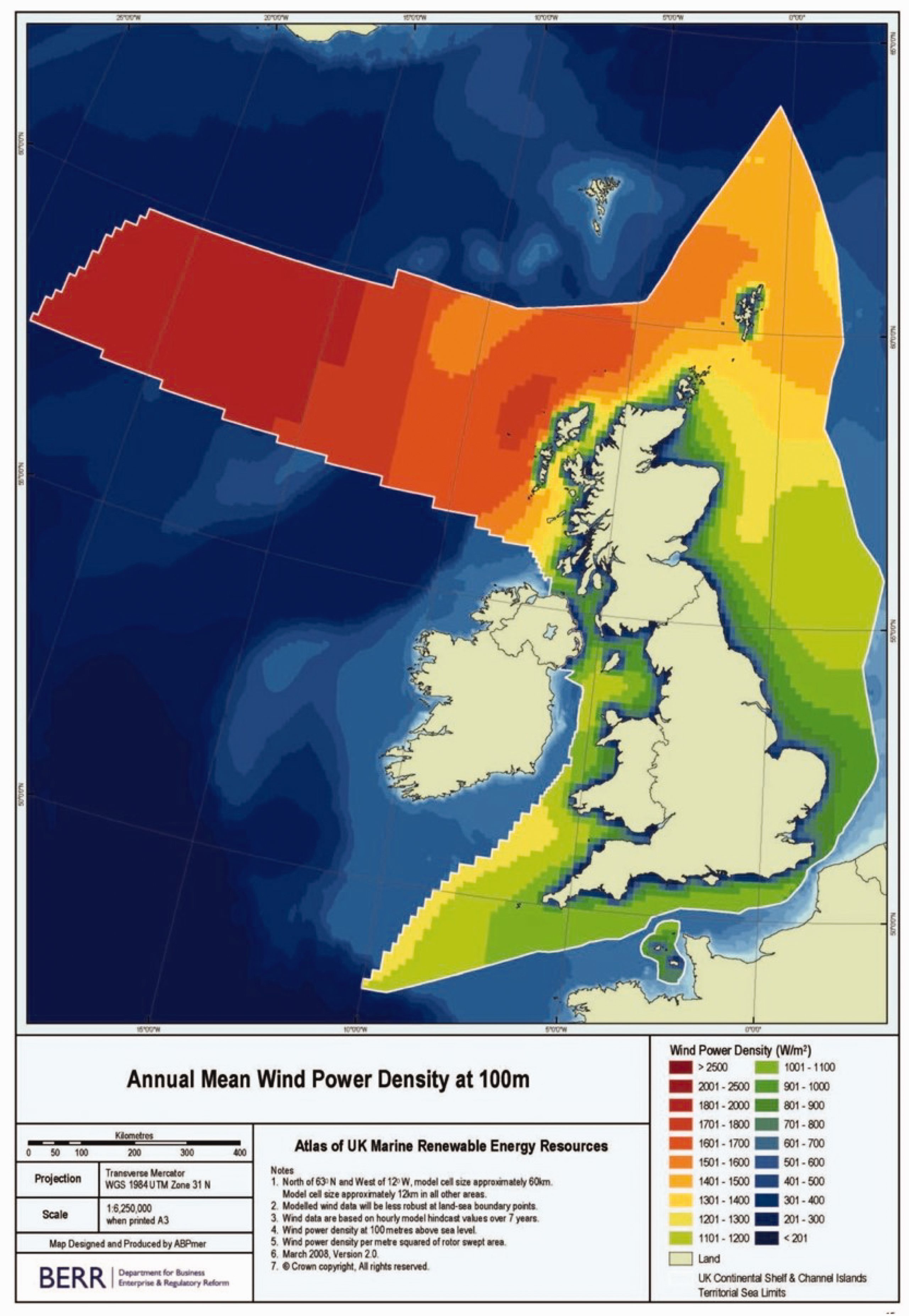
Map of UK wind resources that are imagined to extend to the edge of the continental shelf, expanding claims to territory in areas where states are normally not assumed to exercise full sovereign power under international law. Source: Atlas of UK Marine Renewable Energy Resources Project, © The Crown Estate.
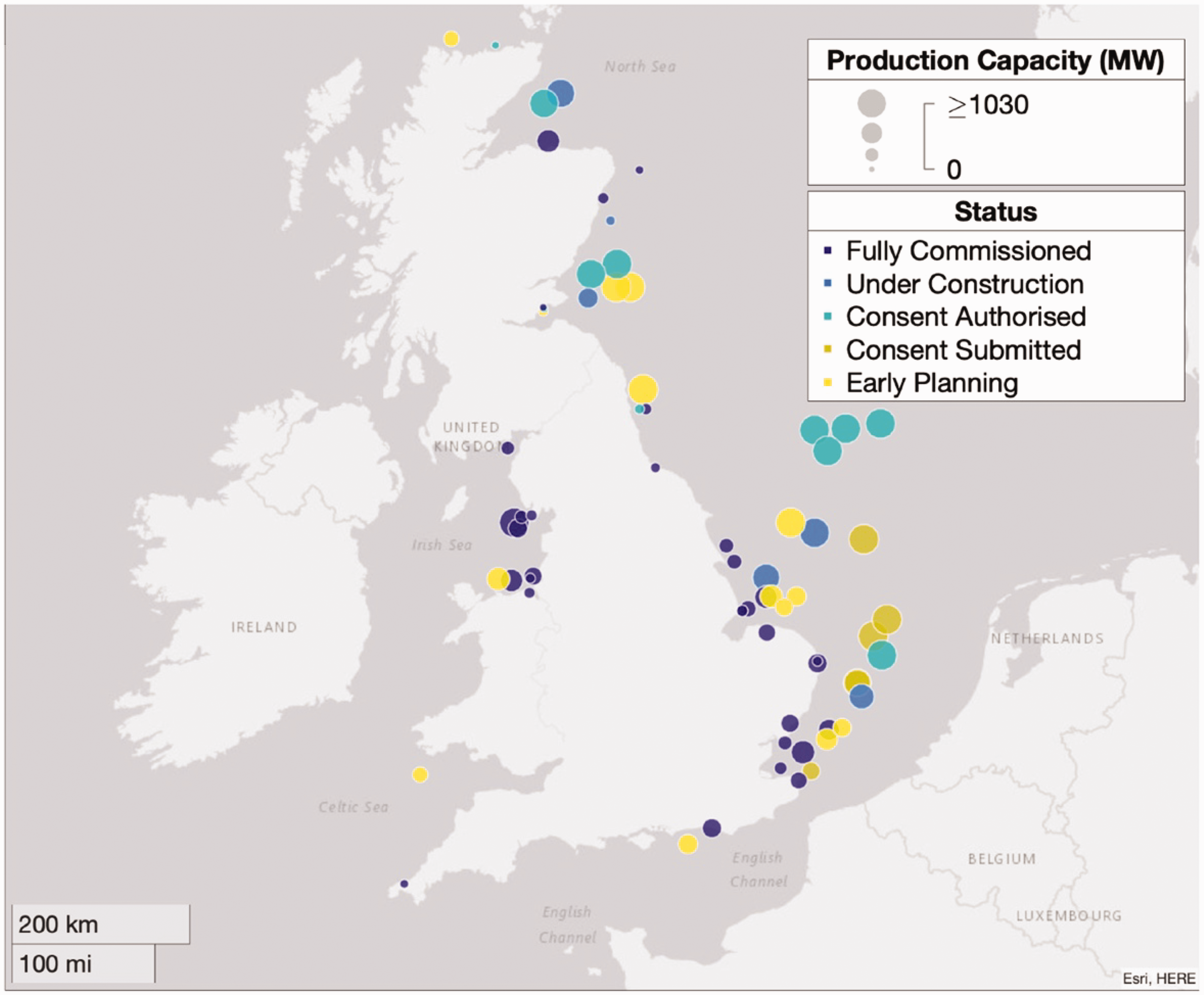
Location of offshore wind farms in the UK as of 2021. Source: Potisomporn and Vogel (2022).
Under international law, states have limited claims to sovereignty over maritime spaces outside of territorial waters (see Figure 1). The major convention, to which all North Sea countries are parties, the United Nations Convention on the Law of Oceans and Seas (UNCLOS), establishes that states have the right to natural resources within EEZ waters, and in subterranean spaces under the continental shelf. In the EEZ, states have the right to the extraction and exploitation of ‘the waters superjacent to the seabed and the seabed and the subsoil’ (Art. 56). This does not include the right to police movement on or above EEZ waters, so long as air or sea travel does not involve natural resource extraction. State sovereignty over the area extending to the edge of the continental shelf, however, is strictly limited to subterranean space (Art. 76). Moreover, the ‘natural resources’ of the continental shelf consists of ‘mineral and other non-living resources of the seabed and subsoil together’ (Art. 77). Similarly, a state does not have the right to police travel on or above waters over the continental shelf (Art. 78).
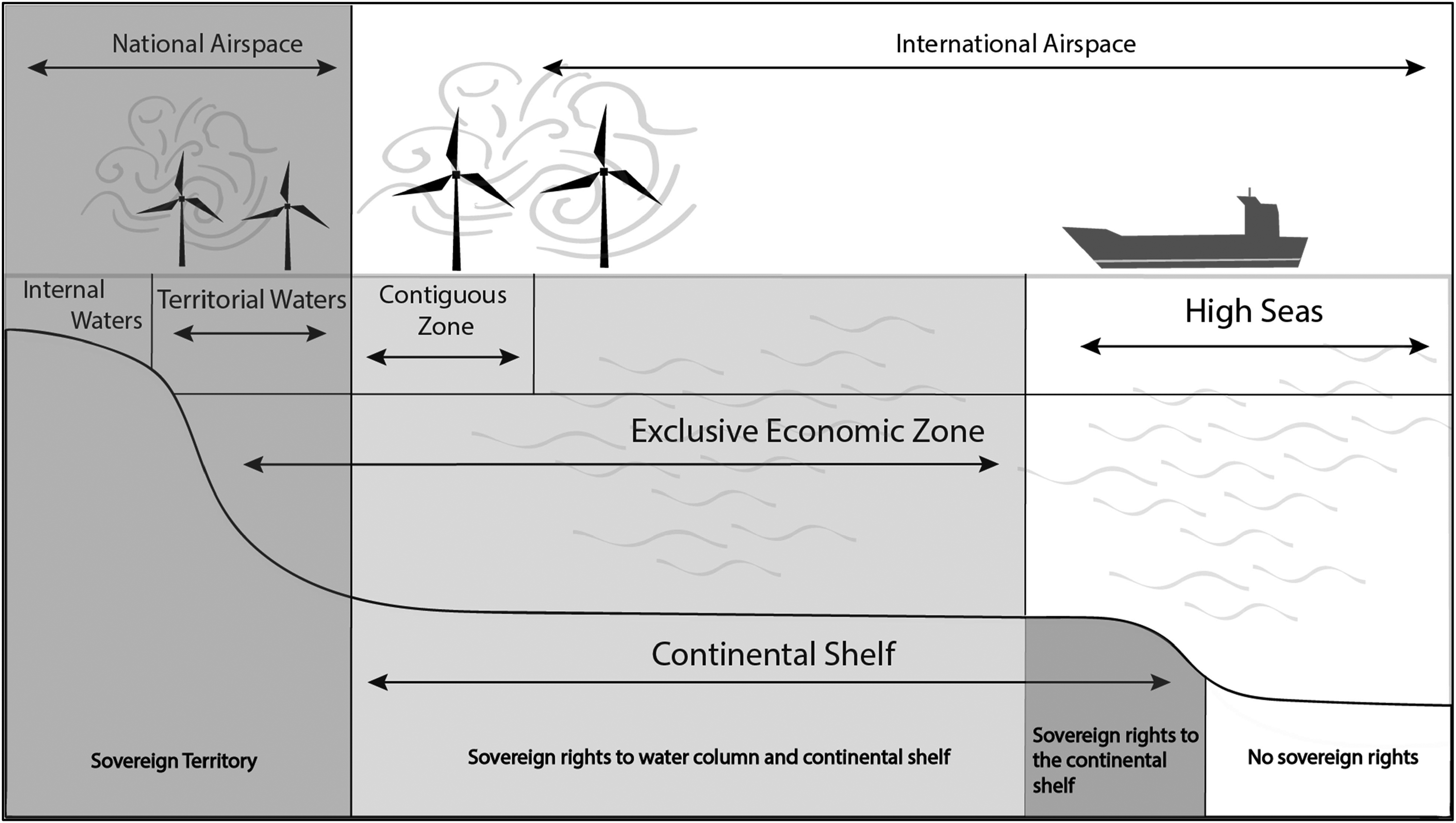
Graduated sovereignty of British maritime territories in the North Sea according to international law. Shaded areas represent different zones of sovereignty. Figure by author.
The Law of the Sea is very clearly oriented towards subterranean spaces, having been shaped extensively by fossil fuel extractivism and its spatial contours, while also establishing that states do not have claims to full sovereignty over airspace and waters beyond the territorial sea. This has been acknowledged in UK legal geographies, and historically UK civil and criminal law was only extended across land and to the edge of territorial waters. 12 In offshore areas beyond territorial waters, the territorial ambit of select laws has been extended to specific areas of fossil fuel extraction and the exploitation of natural resources (such as oil platforms). 13 This, however, is changing. Since 2000, the UK has used wind maps to designate an EEZ (one of the last countries to do so), as well as a ‘Renewable Energy Zone.’ 14 The Renewable Energy Zone maps onto the borders of the EEZ (making the two essentially the same), and is defined as a territory where the UK Crown Estate can exercise its rights to produce energy from water and wind. 15 It is also defined as an area governable by UK law, and the UK has extended legal geographies over surface and atmospheric territories in the EEZ/Renewable Energy Zone beginning in 2004. This was realized through a series of legal provisions, including the Energy Act of 2004, the Marine and Coastal Access Act of 2009, and the EEZ Order of 2013, effectively extending criminal and civil law to the EEZ/Renewable Energy Zone, with the option to extend the territorial ambit of national law to the edge of the continental shelf.
Specifically, the Energy Act of 2004 expanded national law to all acts that take place ‘on, under, or above’ waters around renewable energy sites as if ‘they took place in a part of the United Kingdom.’ 16 At first glance, the language of the Energy Act suggests that the North Sea would be governed by temporary sovereign areas, determined by the presence of renewable energy installations, where national law could be applied flexibly. 17 In theory, once the energy installations were removed, national law would cease to apply to these specific sites (much like how law was previously selectively applied to oil and gas activities). Yet, on closer inspection, it is clear that the Energy Act laid the foundations for the permanent extension of these legal geographies and sovereign performances, including surveillance, the policing of water and air traffic, and the extension of civil and criminal law into the EEZ/Renewable Energy Zone. This was done through the designation of somewhat vague ‘safety zones,’ defined as ad hoc zones determined to be necessary for the production of wind and wave energy, zones over electricity transmission lines (the area of which is undefined), as well as those areas that are being explored for new energy resources (the area of which is similarly unlimited). Together, these provisions make it possible to effectively extend volumetric sovereignty over the entire offshore space, above and below the water, in ways that have not been imaginable before.
These legal provisions further construct the idea that energy resources and energy infrastructures are at risk, and thus require the expansion of national security mandates to conduct surveillance and protection (cf. Bridge et al., 2018). To this end, the Energy Act also included provisions for policing and surveillance of air and sea traffic to ensure the safety and protection of energy resources and infrastructures. The energy industry has worked to interpret these security measures in their favor, with companies attempting to forward arguments that offshore wind projects in the EEZ are located in ‘de facto territorial’ waters that require protection from states, precisely because wind projects are integrated into the national energy infrastructure that link offshore sites to the mainland (Gronholt-pedersen et al., 2023). Energy companies are similarly expanding their own surveillance infrastructures. Wind turbine manufacturers are installing radars to detect passing sea traffic and employing drones to survey activity around sites, data which in turn is shared with the UK coast guard and used to expand the surveillance of seaspaces. More recently, the UK has expressed concerns over Chinese and Russian monitoring of North Sea energy infrastructure, which has further invigorated arguments for the rights of the state to limit free movement in areas containing energy resources or infrastructures. 18 For the UK, energy resources now exist across the entire maritime space.
Wind maps, territorial imaginations, and legal instruments effectively extended the UK legal geography to an additional 298,718 square miles of seaspace, while also expanding claims to sovereignty over new maritime and atmospheric areas (see Figure 7). Through wind maps, the UK delineated new governance spaces, reflecting previous approaches to regulatory frameworks and policies governing fossil fuel extraction, only this time in a far more expansive way. Thus, cartographic representations of wind reveal far more than mere meteorological observations, but rather betray conceptions of space that structure how wind is perceived and represented. Conceptions of space not only influence how wind is imagined to interact within national borders, but also facilitate the envisioning of novel spaces for territorial exploits and the expansion of legal geographies.
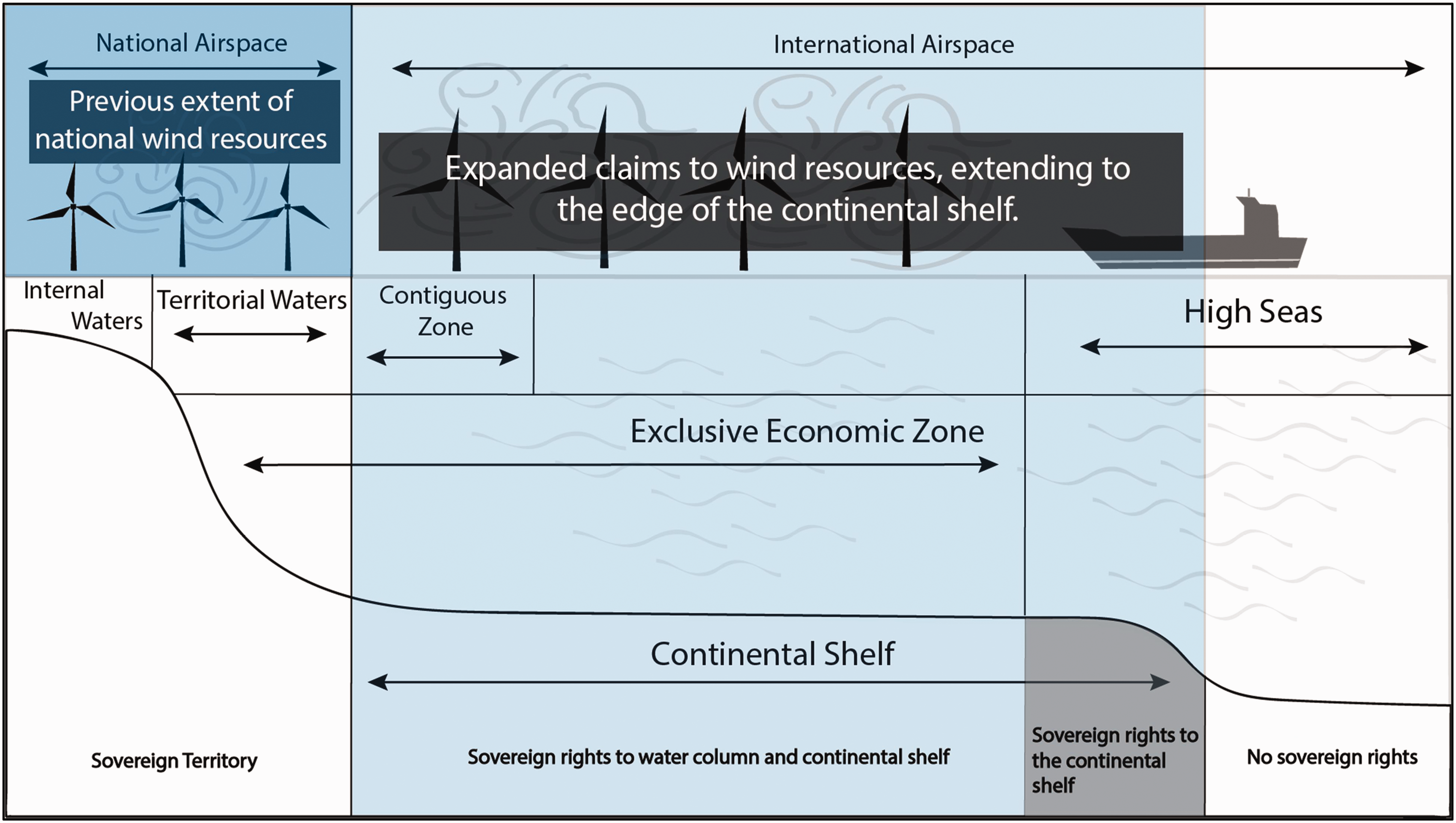
Previous extent of British wind resource claims (left) and expanded state claims to wind resources (right) that extend to the edge of the continental shelf. Figure by author.
Moreover, maps and conceptions of wind resources they produce have also contributed to a new kind of geopolitical and legal problem. Namely, the production of wind resources as the property of specific countries has also given rise to a novel predicament that has come to be called ‘wind theft.’ Wind theft refers to the appropriation of wind from one territory by another actor. When wind farms are built too closely together, power generation can be impacted through wake effects, especially in offshore environments (Frandsen and Barthelmie, 2002). If wind turbines are installed upwind from existing wind farms, they can significantly impact the downwind farm’s power generation by slowing wind speeds. These wake effects can lead to significant losses in power generation for downwind farms (El‐Asha et al., 2017). If these interactions occur between wind farms owned by different companies, individuals, or states, wake effects can result in cases of ‘wind theft’ where a wind generation facility is deprived of wind speeds that were present during the time of construction (Finserås et al., 2024). Because wind farms can ‘steal’ wind from certain areas, they can deprive adjacent areas of future wind development potential by deterring countries and companies from building farms that could be impacted. The possibility of neighboring countries ‘stealing’ wind is contributing to new attempts to map wind in more precise ways in order to trace losses incurred to wind farms, including the expanded (and expensive) use of satellite data to forensically trace wind currents. It has also led to an increasing preference for building wind farms as close to international borders as possible in an attempt to capture both the most wind possible within national boundaries (and potentially a neighboring country’s wind resources), while also reducing the chance that a neighbor would build in that area given the existence of a wind farm that could interfere with electricity production.
The territorial politics of wind resources are not limited to the UK and the North Sea, and similar strategies are being pursued by states around the world. Wind resource maps are invoked to advance certain geopolitical claims, particularly around disputed boundaries and territories, by producing resource spaces that are naturalized as part of state territories. For instance, academics, state actors, and energy companies are advancing competing claims to the South China Sea through maps of national wind resources that represent their particular vision of maritime boundaries. 19 In another example, Greek wind resource maps similarly represent Greek wind resources in areas that are also claimed by Turkey (and where hydrocarbons are known to be present) (Figure 8). The manipulation of supposedly neutral natural resource maps has reached such an extent that some academic journals have voiced their concerns over the territorial projects at work in academic studies. Several journals now have policies regarding the claims made through maps, particularly in disputed border areas, and policies for which sources can be used for ‘official’ borders (Frost et al., 2021). This, however, has not impeded the wide-spread production of wind resource maps, and the spatial visions that both inform their construction and the territorial arguments they forward.
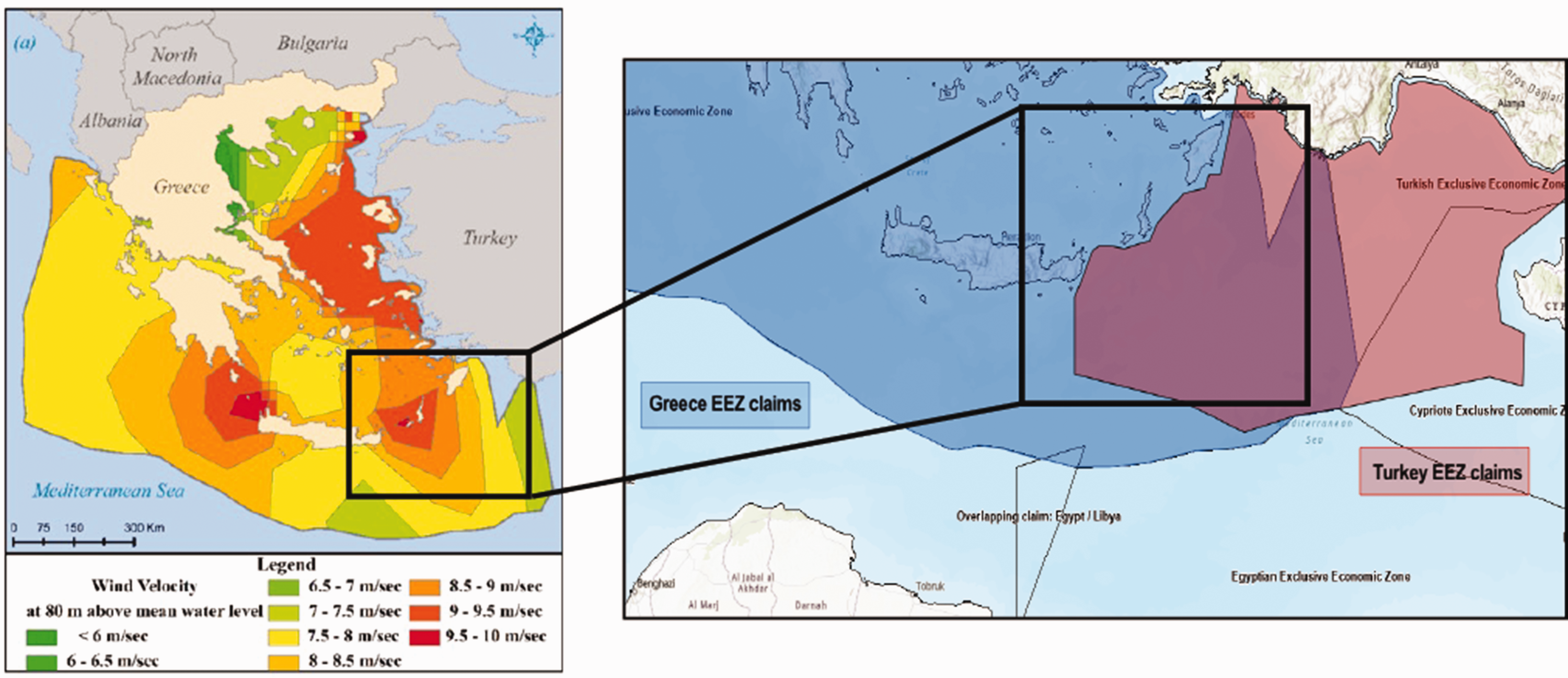
Greek wind maps (left) lay claim to contested marine territories claimed by Turkey (right). Left image source: Spyridonidou et al. (2020). Right figure by author..
Finally, while this article has focused on the production and expansion of territory and sovereign claims through ventographic practices, ventography may have the potential to shape different visions of energy futures. In relation to energy, differently positioned stakeholders are asking critical questions regarding the ownership of wind resources, and how the benefits of wind energy development might be more equitably distributed, including through countermapping efforts (e.g., Avila et al., 2022). It may be that with the rise of ventographic practices, new kinds of throughlines and connections between specific actors and processes can be visually apprehended to advance claims and resource ontologies that can challenge further expansions of imperial power.
Conclusion
In the future we will talk about ecopolitics rather than geopolitics, because geographical limits will be less important than ecological ones in defining areas of interest and power relationships. – Ricardo Navarro 20
Ricardo Navarro, quoted above, imagined that a day would come when natural resource boundaries would overtake the importance of political ones. However, what Navarro perhaps did not envision was how the boundaries of ‘natural’ resources are as much a social production as political borders, or how resources and borders are co-produced. As I have demonstrated here, imaginations of wind resources are shaped by historically-specific conceptions of space. Such representations are in turn lending to the reworking of political boundaries and claims to sovereignty. In tracing UK attempts to transmute wind power into territorial power, it becomes clear that the work to harness wind resources is deeply entangled with territorial ambitions and geopolitical maneuverings. Through resource maps, wind can be claimed as a form of property, that in turn can be owned, leased, and even stolen. These conceptions of wind and its relationship to space are making possible the specific kinds of energy regimes unfolding in the North Sea and around the world. In this vein, the intangible nature of wind, once thought to be beyond the grasp of human spatial politics, is coming to play a role in the reconfiguration of political geographies in altogether new ways.
Moreover, the spatial politics of wind extend beyond the immediate border projects of nation-states, highlighting the geopolitical ‘thickness’ of energy projects (Sneddon, 2015: 2). The competition for newly minted ‘wind resources’ and the strategic positioning of wind energy infrastructure are contributing to the reshaping of larger geopolitical spatial reorientations. State administrations are seeking to extend claims over both their own wind territories as well as neighboring wind resources in attempts to capture wind through spatial strategies of wind farm siting. In this way, the conceptualization, measuring, and utilization of wind resources are taking on new stakes. As wind energy projects undergo expansive global proliferation, ventographic practices will likely intensify, producing new kinds of political geographies in the process. Wind, all too often imagined as the background upon which the social unfolds, is thus coming to play a central role in the evolving dynamics of territorialization and volumetric sovereignty.
Footnotes
Acknowledgements
This article is indebted to those interlocutors who have opened up their worlds and allowed me to take part, particularly those working in the renewable energy industry. Research and writing were made possible through the support of the Social Science Research Council, the Stanford Institute for Research in the Social Sciences, and the Stanford Europe Center. Paulla Ebron, Sylvia Yanagisako, James Ferguson, and Kabir Tambar provided crucial guidance for my research throughout the process. Sharing this article at the Society for Social Studies of Science Annual Meeting in 2023 helped it take shape. Special thanks to Sungeun Kim, Chihyung Jeon, Jesse Rodenbiker, and Fran Meissner for our discussion on the intersections of territoriality and environmental sciences which helped me refine my arguments. Comments and suggestions from two anonymous reviewers and editor Andrew Curley helped strengthen the article. All remaining oversights and errors are my own.
Declaration of conflicting interests
The author(s) declared no potential conflicts of interest with respect to the research, authorship, and/or publication of this article.
Funding
Research for this article was generously supported by the Social Science Research Council, the Stanford Institute for Research in the Social Sciences, and the Stanford Europe Center.