
Abstract
The Jin77 well block is a highly promising area in the Hangjinqi region of the Ordos Basin. However, there were few wells and little geological research in this area. In order to better understand the sequence and depositional characteristics of the Xiashihezi Formation 1 Member (also known as the He1 Member) in the Jin77 well block, as well as to describe the sedimentary microfacies distribution of the development Sublayer unit, a thorough integration and calibration of core, logging, and seismic data were conducted. By analyzing the comprehensive response characteristics of logging and seismic data, we were able to subdivide the strata of the Xiashihezi Formation and establish a high-frequency sequence framework within the study area. The He1 Member was found to consist of 4 Sublayers, each with a consistent thickness. Based on the analysis of fine cores, it was determined that the dominant sedimentary type in this area was that of a wandering, shallow braided river. This conclusion was supported by the observed lithofacies marks, vertical facies sequence, and horizontal distribution of sandstone bodies. By combining the analysis of logging and seismic data with the results of the detailed Sublayers subdivision, the relative isochronous boundaries were able to be identified. The use of geophysical slicing technology, along with well and seismic data, it was allowed to effectively characterize the microfacies boundary of the braided river within the H1-1 sublayer unit. The findings show that the H1-1 sublayer contains approximately four to five braided river channels, with widths ranging from 1.5 to 6.5 km. These results provide valuable information for reservoir prediction and the detailed description of Sublayer units.
Keywords
Introduction
The Jin77 well, located in the Jin77 well block of the Hangjinqi area in the northern part of the Ordos Basin, demonstrated a high-yield industrial gas flow of 33,000 m3 per day during the productivity testing of the Xiashihezi Formation 1 Member (also known as the He1 Member). This indicated potential for exploration and development (Fu et al., 2019; Hao et al., 2016; He et al., 2020; Sun, 2016; Yao et al., 2018; Zhang et al., 2021, 2024). The adjacent Jin72 and Jin58 gas reservoirs of the He1 Member on the west side of this area are mainly composed of low-permeability and tight lithologic gas reservoirs and structural-lithologic gas reservoirs (Sun, 2016; Zhang et al., 2021). Therefore, sedimentary microfacies play a significant role in controlling reservoir development and distribution (Li et al., 2020; Zhang et al., 2021). However, previous studies have not conducted detailed research on the stratigraphy and sedimentary characteristics of the target layer in the Jin77 well block. Only a few scholars have analyzed the deposition of the He1 Member in the Hangjinqi area, and have concluded that the sedimentary facies types are fluvial facies and delta facies (Li et al., 2013). Given the close proximity of the Hangjinqi area to the northern edge of the basin, with a significant East-West span, and the varying paleogeomorphological influences across different regions, the stratum thickness and sedimentary characteristics are likely to vary. As a result, the aforementioned studies on the sedimentation of the He1 Member in Hangjinqi may not accurately represent the stratigraphy and sedimentary characteristics of the target layer in the Jin77 well block.
Currently, the predominant development well type in the Hangjinqi area is a horizontal well. However, the gas reservoir description and evaluation are conducted with the He1 Member as the development target, which presents challenges in meeting the needs of field horizontal well deployment or evaluation. As a result, the research focus has shifted to the sublayer and single sandstone body. However, the Jin77 well block has numerous sets of sandstone bodies, characterized by a complex sedimentary structure and rapid lateral facies transition. The conventional sublayer division and correlation method has been found to be ineffective in this area (Han et al., 2018). For low-permeability tight gas reservoirs, fine division of development units is not only the basis for geological analysis, but also enables the extraction of geophysical attributes based on sublayer framework constraints. This can be combined with geostatistics inversion and other methods to more effectively and reliably predict sedimentary facies and reservoirs, and improve the accuracy of reservoir prediction (Liu et al., 2020; Nunes et al., 2017; Wei et al., 2002). The classical sequence stratigraphy theory has achieved considerable success in the division and correlation of thick layer units based on the concept of “Formation or Member.” However, it has rarely been applied to the division and correlation of sublayers or single sandstone bodies in the development (or development evaluation) stage. High-frequency sequence stratigraphy provides a novel theoretical basis for the division of sublayers. The term “high-frequency sequence” is used to describe a stratigraphic sedimentary sequence formed by fourth-order or above high-frequency cycles (Mitchum and Van Wagoner, 1991; You et al., 2006). The fundamental reason for its formation is that it was controlled by the Milankovitch astronomical cycle of different scales and levels (Brett et al., 1990; Mei et al., 2000; You et al., 2006). The high vertical resolution of logging curves provides the basis for the study of high-frequency sequences and makes up for the lack of coring restrictions (Moradi, 2019a, 2019b). However, the finer the division of high-frequency sequences, the more influencing factors, and the greater the difficulty of cross-well horizontal correlation. Vail et al. (1977) proposed that seismic reflection interfaces usually represented chronostratigraphic interfaces such as bedding interfaces and unconformities, and the continuity of their distribution could reflect the horizontal distribution of strata (Vail et al., 1977), which had become an indispensable technology in the description of oil and gas reservoirs.
In the study of plane sedimentary microfacies distribution of clastic rocks, single well microfacies were typically employed as a primary data source, in conjunction with sandstone body distribution direction, sedimentary facies type, and sedimentary mode, and inter-wells difference method was frequently employed to analyze the distribution of sedimentary facies (Li et al., 2020). However, the accurate characterization of plane sedimentary microfacies distribution often required a substantial amount of well data. The sedimentary characteristics of the He1 Member in the Jin77 well block are complex, with an average of one well within 20–30 km². It is evident that it is challenging to describe the plane microfacies boundary of the He1 Member at the sublayer level in a less well-studied area using limited well data. In these cases, a comprehensive characterization of sedimentary microfacies through a combination of well and seismic data may be a promising solution (Li et al., 2016). However, the vertical resolution of seismic data in the study area is limited, making it difficult to distinguish between sublayers. While acoustic impedance geostatistics inversion can enhance vertical resolution, the heterogeneity of channel sandstone bodies and lithologic assemblage types can complicate the seismic response of sandstone bodies. Additionally, the overlap of sandstone and mudstone impedance in the target layer in the study area can lead to uncertainty in the inversion results (Li et al., 2020; Ling et al., 2010; Xia et al., 2013; Xi et al., 2009). It is important to note that while the vertical and horizontal resolutions of three-dimensional (3D) seismic data are approximately equal, the horizontal distribution of sedimentary geological bodies is typically much larger than the vertical distribution. This means that it may be easier to identify sedimentary bodies in the horizontal or plane rather than the vertical direction (Galloway and Hobday, 1983; Li et al., 2022; Zeng et al., 2012; Zhu et al., 2019). In conclusion, the seismic profile can be calibrated in detail through the identification of sequence interfaces in a single well. By combining well and seismic data, the high-frequency sequence interface can be accurately identified and used to establish a framework for sublayer division and relative isochronous surface definition. This method is one of the most effective ways to solve the issue of sublayer correlation and the planar distribution of sedimentary microfacies in less well-studied areas (Xie, 2021).
This paper employed the core log consistency calibration of the high-frequency sequence interface to identify the whole well section (high-frequency) sequence, in conjunction with the horizontal continuity of seismic data. The sublayer correlation was carried out under the constraint of seismic reflection (Xie, 2021). The study of lithofacies marks, vertical facies sequence, and other factors determined the type of sedimentary microfacies of the target layer in this area. Furthermore, through well seismic calibration, the seismic reflection characteristics of the wells sidetrack were counted, and the geophysical attributes of the favorable sandstone body distribution were determined. In the context of a high-frequency sequence framework, relative isochronous surfaces were employed to extract the seismic attributes of the H1-1 sublayer of the He1 Member. This was achieved through the use of stratigraphic slicing technology, which enabled the comprehensive determination of the plane distribution of sedimentary microfacies of the Sublayer units. The resulting geological basis provided a foundation for the evaluation and deployment of horizontal wells. Furthermore, the research outcomes could serve as a framework for evaluating the distribution of reservoirs and predicting the geophysical characteristics of facies-controlled reservoirs, offering significant theoretical and practical insights.
Geological background of the study area
The Hangjinqi area is situated at the northern margin of the Ordos Basin, which exhibits a monoclinal structure with a high NE and low SW trend. The area is characterized by three major faults, namely Sanyanjing, Wulanjinlimiao, and BoerjiangHaizi, which run in an EW and NE direction (Luo et al., 2021). The Jin77 well block is situated to the north of the Yishan slope structure and in close proximity to the Jin72 well block to the west. The study area, which is represented by the yellow area shown in Figure 1, covers an area of ∼ 540 km2 (Cao et al., 2021).
The structure characteristics of the Hangjinqi area, the location of the Jin77 well block, and the comprehensive column of the Upper Paleozoic strata (modified according to Li et al., 2021).
During the late Caledonian movement, the Guyinshan Mountain in northern Ordos was uplifted and folded, providing provenance for the deposition of Carboniferous and Permian clastic rocks (Cao et al., 2021). The Carboniferous Taiyuan Formation is a set of interbedded (gravel-containing) quartz sandstone and dark mudstone, and intercalated with thin carbonaceous mudstone and coal interbeds (Guo et al., 2009). It is a transgressive sedimentary sequence developed on the Caledonian ancient erosion surface. During the sedimentary period of the Shanxi Formation, the sedimentary environment transitioned from marine to terrestrial, with a predominant composition of sandy conglomerate, sandstone, mudstone, and coal seams, reaching a thickness of 50–80 m (Zhao et al., 2020). During the sedimentary period of the Xiashihezi Formation, there was a significant difference in elevation and subsidence between the North and South, resulting in the uplift and southward tilt of the northern margin of the Ordos Basin. This also led to a gradual change in paleoclimate from semi-arid to arid conditions. In the Hangjinqi area, an alluvial fan to braided river sedimentary system developed (Chen et al., 2011) with the Xiahehezi Formation reaching a thickness of ∼ 120 m. The predominant lithology consists of light grey gravelly coarse sandstone, gray-white medium-coarse sandstone, and light gray-green quartz lithic sandstone, interspersed with gray-green silty mudstone, reddish-brown mudstone, and variegated mudstone. The He1 Member, He2 Member, and He3 Member are the three main gas-bearing reservoir development intervals, with He1 Member being the most significant (Cao et al., 2021) (Figure 1).
Establishment of a high-frequency sequence framework
The establishment of a high-frequency sequence framework is crucial for accurately describing gas reservoirs. This framework is based on the division of gas reservoir development units within the high-frequency sequence. The reliability and precision of this framework directly impact the accuracy and precision of gas reservoir description (Jia and Cheng, 2012). To establish this framework, the theory of sequence and high-frequency sequence was used, and the core interface, logging interface, and seismic interface were calibrated with each other. Additionally, the integration of well seismic data was used to enhance the accuracy of seismic horizon interpretation and the isochronism of seismic attribute slices. The identification and division of key boundaries of the third-order sequence were crucial in establishing the high-frequency sequence framework.
Identification and division of key boundaries of third-order sequence
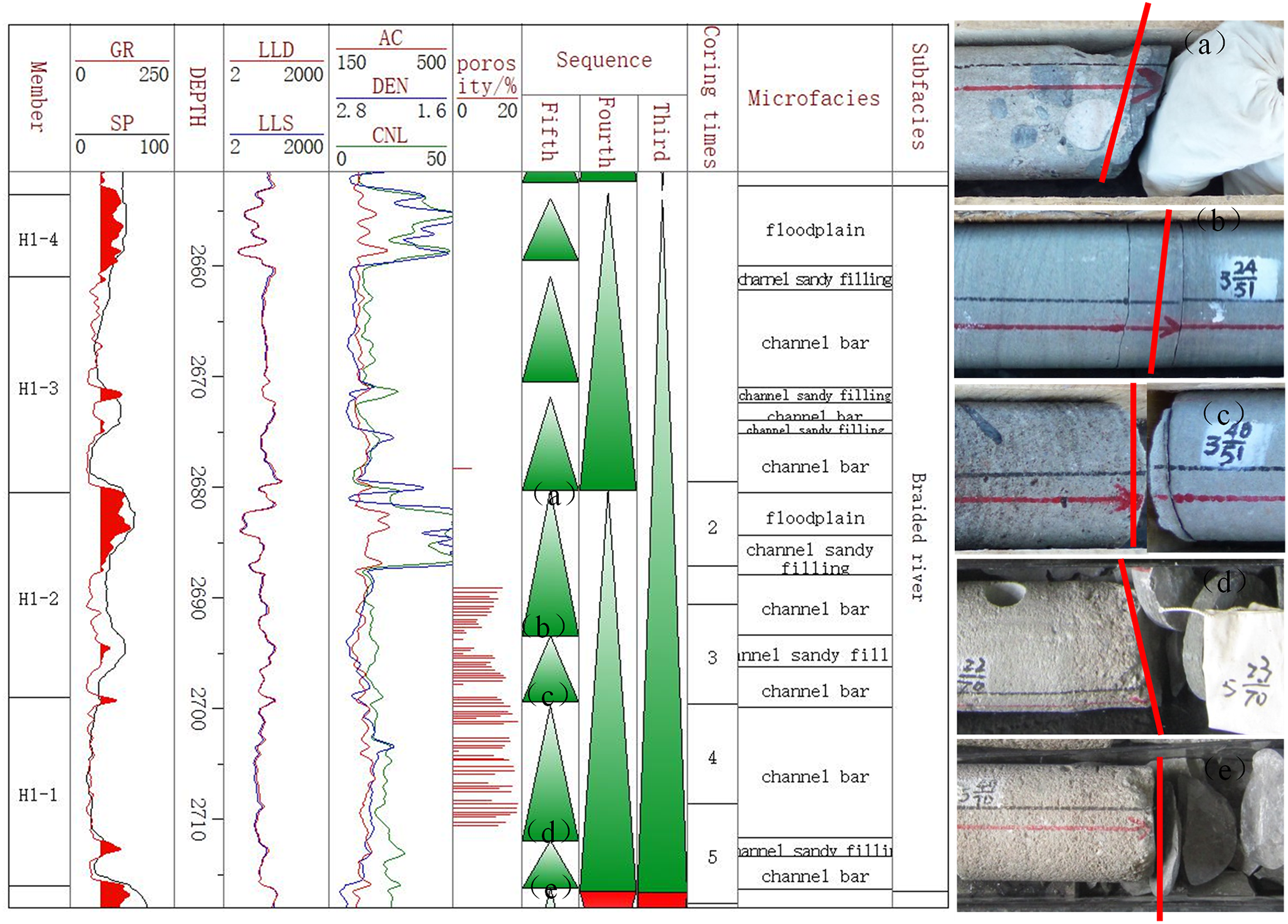
In the study area, the Xiashihezi Formation has a thickness of ∼ 120 m. The sequence boundary of this formation was identified using detailed logging description data, core observation, calibration logging curves, and a combination of lithologic and electrical response characteristics of electrical logging curves. The well Jin77 was used as a representative. The Xiashihezi Formation was divided into a complete third-order sequence, designated SQ1, with SB2 and SB1 as the top and bottom boundaries, respectively (Figure 2). The SB1 interface (Xiashihezi Formation (H)/Shanxi Formation (S) interface) represents the boundary between the “camel neck sandstone” of the Xiashihezi Formation and the gray-black mudstone of the plain marsh microfacies at the top of the Shanxi Formation. This interface is a typical undercut scouring surface, formed by the river undercutting when the sedimentary base level of the Xiashihezi Formation dropped. This resulted in the scouring and erosion of the underlying Shanxi Formation's dark mudstone formation to varying degrees (Li et al., 2023; Shao et al., 2008). The natural gamma (GR) curve displays an abnormally low value, and there are significant differences in lithology and lithofacies marks above and below the interface (Li et al., 2023; Moradi, 2019a, 2019b; Shao et al., 2008). The natural gamma (GR), deep lateral resistivity (LLD), and three porosity curves exhibit clear mutation characteristics, making them easily identifiable within the study area. The top boundary SB2 of the third-order sequence represents the interface between the Shangshihezi Formation (P2 s) and the Xiashihezi Formation (H). The lithology of the Shangshihezi Formation base is predominantly gray-purple lacustrine mudstone interbedded with variegated sandstone. The spontaneous potential (SP) is clearly positive on the logging curve, while the deep lateral resistivity (LLD) is low, in contrast to the mudstone or sandstone of the underlying Xiashihezi Formation He3 Member (Figure 2). The third-order sequence boundary is a typical sedimentary exposed surface, formed by the decline of the sedimentary base level, insufficient sediment supply, and the exposure and oxidation of mudstone (Li et al., 2023; Shao et al., 2021).
Comprehensive analysis column of sedimentary facies and (high-frequency) sequence from the Xiashihezi Formation in well Jin77, the Ordos Basin.
The sedimentary paleotopography of the Hangjinqi area does not exhibit a discernible slope break, and no lowstand system tract (LST) deposition can be identified in the traditional sense. As a result, the third-order sequence is mainly composed of ascending and descending cycle system tracts (Li et al., 2020). In most of the study area, the top of the He1 Member is typically developed with a low-resistivity mudstone layer, ∼ 5–10 m thick. The natural gamma (GR) logging response shows relatively high values, and the medium to low resistance (LLD) is clear (Figure 2). This layer can form a relatively obvious lithologic interface with the overlying He2 Member, which is a better recognizable local marker layer. This interface has a clear lithological property of transforming the system tract from coarse to fine and then to coarse (Figure 2), making it suitable as the system tract interface of the third-order sequence (Li et al., 2023). Therefore, in this third-order sequence, the He1 Member of the Xiashihezi Formation is primarily composed of an ascending cycle system tract, while the He2 + 3 Member is composed of a descending cycle system tract, resulting in a symmetrical cycle.
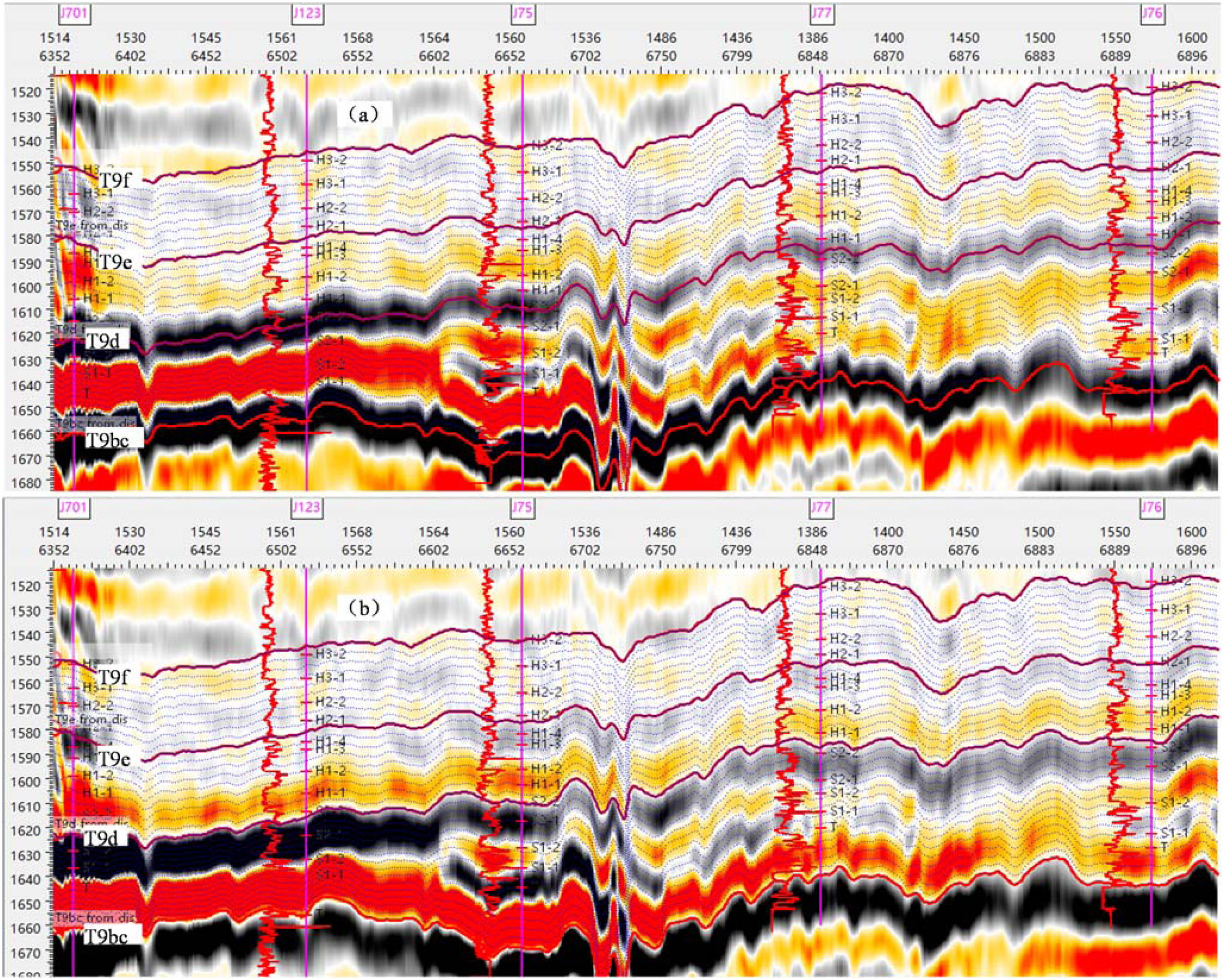
The seismic reflection of SB1 at the bottom of the third-order sequence is a continuous strong wave peak (T9d), which serves as a regional seismic reflection standard interface. This is clearly displayed on the seismic profile and can be continuously tracked in the study area (Figure 3). It is generally accepted that the top boundary SB2 of the third-order sequence in most areas of Hangjinqi is characterized by a weak peak reflection on the seismic profile. However, in the study area, the actual well seismic calibration results indicate that the majority of the boundary is located at zero phase, resulting in the actual tracking being zero-phase T9f. The energy and phase of the T9f wave in the study area vary considerably, and the lateral stability of the wave group is poor, making it challenging to identify and correlate. To address this issue, the correlation method of approximately equal thickness and formation thickness trend should be adopted for identification and tracking (Figure 3). The maximum flooding surface (MFS) of the system tract interface represents the top and bottom interfaces of the He1 Member and He2 Member. It can be calibrated and tracked on the majority of seismic sections, exhibiting medium to weak energy and intermittent moderate-intensity peak reflection (T9e) (Figure 3). Although there may be some cross-merging of seismic reflection events, the MFS is still a relatively good recognizable local marker layer interface.
Sequence and system tract division through the Jin74–Jin77 well on seismic profile in the Jin77 well block, Hangjiqi area (see Figure 1C and D for profile lines).
In order to accurately correlate the sequence boundary and system tract interface, the seismic reflection characteristics of the well seismic calibration results should be used as an important reference. This involves cross-well tracking and correlation of the sequence boundary and system tract interface to avoid the correlation of cross layers (Li et al., 2016, 2020). During this process, the sequence and system tract interfaces identified by logging should be mutually constrained and verified with the corresponding interfaces on the seismic profile to avoid large contradictions and errors. The results of the well-to-well correlation of the third-order sequence and system tract interfaces, when combined with well seismic data, show that the thickness of the Xiashihezi Formation in the study area has relatively small changes. In the vertical provenance EW direction, the thickness of the formation is consistent, with slight thickening in the south and thinning in the north along the provenance SN direction (Figures 3 and 4). This is mainly influenced by the sediment provenance in the study area from the north of the basin.
East-west high-frequency stratigraphic correlation of the Xiashihezi Formation crossing Jin701-Jin76 wells (see Figure 1A and B for profile lines).
Identification and correlation of high-frequency sequence interfaces
This article focuses on the identification and correlation of high-frequency sequences, which are sedimentary responses generated by fourth-order and above-base-level cycles. These cycles were first described by Milankovitch (Li et al., 2017; You et al., 2006) and are roughly equivalent to Brett's parasequence set (Brett et al., 1990; Li et al., 2017; You et al., 2006). The fifth-order high-frequency sequence, formed during shorter Milankovitch periods, is also comparable to Vail's single-layer sequence or Brett's parasequence (Brett et al., 1990; Li et al., 2017; You et al., 2006). To identify and divide the high-frequency sequence interfaces in the study area, multi-well correlation results of third-order sequence interfaces were used. Detailed core observations were then conducted to analyze lithologic mutations, scouring, and erosion above and below the fourth- and fifth-order high-frequency sequence interfaces. Logging curves were calibrated using the high-frequency sequence interfaces, and their variation characteristics were summarized. This allowed for the identification and division of high-frequency sequence interfaces in all wells within the study area (Moradi, 2019a, 2019b). Detailed core observations revealed that the high-frequency sequence boundary of the He1 Member in this area was primarily composed of channel scouring surfaces, lithologic lithofacies transition surfaces, and flooding surfaces.
Channel scouring surfaces: they were formed by strong erosion and undercutting of the river on underlying mudstone or (silty-fine) sandstone (Figure 5(a), (c) and (e)). These surfaces were typically found in the early formation of river channels and were characterized by obvious lithologic mutation at the upper interface of the core. This type of interface was common in the study area and was the most important high-frequency sequence interface type.
Identification and delineation of high-frequency stratigraphic interfaces based on cross-calibration of cores and logging curves in Jin77 well. (a) Interface between channel scouring lag conglomerate and siltstone; (b) Interface between sandstone and siltstone; (c) The interface between gravelly sandstone on the channel scouring surface and underlying fine sandstone; (d) Interface between coarse sandstone and argillaceous siltstone; (e) The interface between gravelly coarse on the river scouring surface and underlying mudstone. All cores are 10cm in diameter.
Lithologic lithofacies transition surfaces: they were also prevalent in the study area. These interfaces were formed by a decline in a sedimentary base level that was either greater or less than the subsidence rate of the basin. This results in a positive rhythmic structure from coarse to fine or a reverse rhythmic structure from fine to coarse in lithologic grain size. An example of this was the lithologic lithofacies transition surface with a positive rhythmic structure from coarse to fine in the He1 Member (Figure 5(b) and (d)).
Flooding surfaces: they were formed when the baseline cycle reached its maximum and began to decline or transition. These surfaces were characterized by mudstone deposits in the middle and top of the He1 Member.
Based on the core identification of the main high-frequency sequence interfaces in the study area, logging curves were calibrated in detail and their response characteristics were summarized. This allowed for the division of high-frequency sequences in all target intervals within the study area. The logging curve mutation characteristics of high-frequency sequence boundaries formed by river channel scouring were obvious, particularly in the gamma curve. This showed a low gamma mutation at the high-frequency sequence boundary, with similar characteristics seen in the resistivity and three porosity curves. In each high-frequency sequence, the logging gamma curve gradually increased with the increase of shale content, forming a normal cycle sediment with finer grain size upwards (Li et al., 2017) (Figure 5(a), (c) and (e)). While the mutation characteristics of resistivity and other electrical logging curves might not be as obvious, the high-frequency sequence boundary formed by lithologic transformation still had a response in the natural gamma (GR) curve, which could be divided according to the lithological change trend reflected by the logging curve (Figure 5(b) and (d)). Thick mudstone was typically found under the high-frequency sequence boundary formed by flooding surfaces, showing “two highs and two lows” characteristics of abnormally high natural gamma (GR), high neutron porosity (CNL), low resistivity (LLD), and low density (DEN) on the logging curve (Figure 5).
A comprehensive analysis of sequence boundaries and well logging has led to the conclusion that the Xiashihezi Formation can be divided into a complete third-order sequence (Figure 2). The He1 Member primarily consists of an ascending cycle system tract. Further analysis of well logging data has identified high-frequency sequence boundaries, such as channel scouring surfaces, lithology lithofacies conversion surfaces, and flooding surfaces, indicating that the He1 Member can be further divided into two fourth-order sequences and seven fifth-order sequences. The high-frequency sequence framework was established using seismic profiles and third-order sequence correlation profiles (Figure 4). The seven fifth-order sequences of the He1 Member were then divided into four sublayers based on the high-frequency sequence framework and field development needs. Among these sublayers, the H1-1, H1-2, and H1-3 sublayers contain well-developed sandstone bodies with a consistent thickness of 15–20 m. The horizontal correlation between high-frequency sequences is relatively stable. The H1-4 sublayer primarily consists of mudstone (Figure 4).
Comprehensive analysis and boundary characterization of sedimentary microfacies
Analysis of rock sedimentary structure and sedimentary facies indicators
Observation of cores in this area revealed the presence of gravelly coarse sandstone and coarse sandstone in the He1 Member of the Xiashihezi Formation. Conglomerate, glutenite, and medium-fine sandstone were also found in localized areas. The composition of the rock particles was complex and variable, with poor sorting. The glutenite was relatively well-rounded, indicating near-source traction flow sedimentation. Conglomerate and glutenite were typically found at the base of the sedimentary cycle. A directional (fine) conglomerate was observed to erode the underlying mudstone or fine-grained oblique bedding fine sandstone. High-energy sedimentary structures, such as massive bedding, trough cross-bedding, and plate cross-bedding, were developed in gravelly coarse sandstone. The lithological and sedimentary structural characteristics of the area suggest the presence of strong hydrodynamic river channel lithofacies (Figure 6). This included bottom-scoured river channel (sandy) conglomerate lithofacies, large trough cross-bedding (gravel-containing) coarse sandstone lithofacies, and medium-sized plate cross-bedding coarse sandstone lithofacies (Figure 6(a) to (e)), occasionally mixed with thin argillaceous siltstone and mudstone deposition in the layer strip. This reflected the repeated superimposition of channel bars in the braided river center. At the top of the upward fining sedimentary cycle, sandstone lithofacies in oblique bedding, medium-fine sandstone lithofacies in parallel bedding, and fine sandstone in sand-striated bedding were typically observed (Figure 6(f) and (g)). This cycle was likely formed by river diversion or sandy filling during the dry season. Additionally, grayish-green mudstone, brown mudstone, and variegated mudstone were observed in the He1 Member, with a thickness of 5–10 m. This deposit was muddy and occurred in the floodplain. Plant charcoal fossils were occasionally found in partial sections of the mudstone (Figure 6(h)).
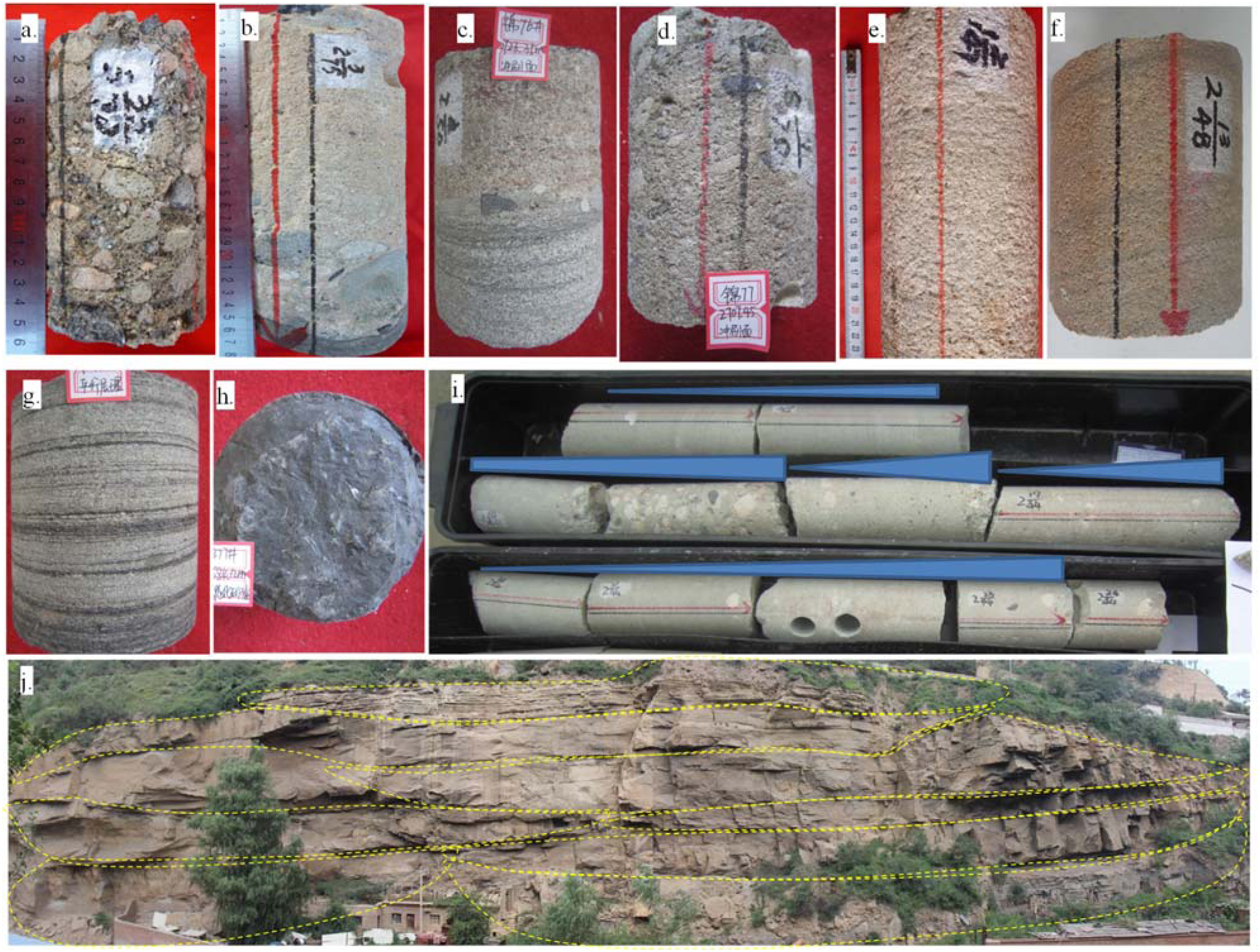
Characteristics of sedimentary structures of cores from the Xiashihezi Formation 1 Member in the study area. (a) Jin77, 2712.2m, grayish white glutenite, channel lag sedimentation; (b) Jin74, 2678.6m, The structure of scouring surface, gray white sandy conglomerate, quartz gravel, debris gravel and mud gravel on the interface, with the maximum gravel diameter of 60mm, and dark gray mudstone at the bottom; (c) Jin76, 2723.35m, scouring surface; (d) Jin77, trough cross bedding gravelly coarse sandstone; (e) Jin56, 2707.45m, large trough cross bedding, 2720.15m; (f) Jin75, 2774.59m, gray white medium sandstone mixed with gray argillaceous strips, presenting oblique bedding; (g) Jin.76, medium fine sandstone with silty mudstone strips, parallel bedding; (h) Jin 77, 2684.12m, plant fossil impression; (i) The braided channel has an atypical binary structure, and the sediment thickness of the lower riverbed is much greater than that of the upper embankment and overtopping, Jin75, 2774.6-2776.8m; All cores are 10cm in diameter. (j) The multi-stage stacking characteristics of the sandstone body in the channel bar of the He1 Member, the Baolou Gou outcrop profile, Baode county, Shanxi Province.
The vertical combination of the entire core section revealed the positive rhythmic sedimentation of multi-stage superimposed coarse sandstone rock in the He1 Member of the area. This reflected the formation process of shallow braided river sedimentation under the action of strong hydrodynamic forces. The coring section of the He1 Member (2774.6–2776.8, with a cumulative length of ∼ 2.5 m) of the Jin75 well primarily consisted of four normal cycle deposits, with a thickness of 0.3–1 m, forming four upward shallowing meter-scale channel sedimentary sequences (Figure 6(i)). At the base of each cycle, there was typically a distinct channel scouring surface, comprising the lowermost glutenite section, the middle and lowermost (gravel-bearing) coarse sandstone section, and the uppermost medium-to-fine sandstone section (Figure 6(i)). This formed a sedimentary sequence of (sandy) conglomerate, gravel-bearing coarse sandstone, coarse sandstone, medium sandstone, or fine sandstone. The sequence exhibited an evident asymmetric “binary structure” indicative of a river environment. The thickness of the riverbed subfacies was considerably greater than that of the embankment subfacies, indicating a typical “sandstone-wrapped mudstone” sedimentary structure. This intermittent positive rhythm reflected the shallow river water body, strong hydrodynamic force, wide river channel, easy migration, underdeveloped bank subfacies, and vertical cutting and stacking of sandstone bodies in each stage. Additionally, the sedimentary period was characterized by underdeveloped mudstone interlayers. The field outcrop Balougou profile of Baode county in Shanxi Province also shows that the sandstonebody in the channel bar of the He 1 Member has obvious characteristics of multi-stage stacking (Figure 6(j)).
The sedimentary microfacies and their logging response characteristics
The cores from the study area indicated that it was a wandering braided river deposit with low accommodation space and high deposition rate (Eaton et al., 2010; Wang et al., 2017). The vertical combination of superimposed lithofacies was used to calibrate the logging curves in detail, and the logging response characteristics of braided river sedimentary microfacies were analyzed. Based on the sedimentary model and microfacies types of wandering shallow water braided rivers, it was believed that the He1 Member in this area mainly contained three microfacies: channel bar, channel sandy filling, and floodplain.
The channel bar microfacies were primarily developed in the middle and lower parts of the vertical facies sequence. At the base, a thin layer (generally < 30 cm) of conglomerate or sandy conglomerate of channel lag deposit was formed due to channel scouring surfaces. This gradually changed upward into a trough or plate-shaped cross-bedding (gravel-containing) coarse sandstone lithofacies (Figure 6(a) to (e)). Some coarse sandstone cores might exhibit relatively uniform massive bedding. The predominant lithology of the channel bar microfacies was (gravel-containing) coarse sandstone, intercalated with thin layers of silty mudstone or argillaceous siltstone. These layers represented suspended deposition formed by the decline of hydrodynamic force at the end of each flood. The shallow and wide braided river environment allowed for the formation of the channel bar by vertical accretion or downstream accretion of coarse-grained sediments during repeated periodic floods. These deposits were cut and overlapped in the vertical direction (Yu et al., 2004). The natural gamma curve of the channel bar microfacies was predominantly characterized by high amplitude, medium-high amplitude toothed box type, with the majority of bottom mutations attributed to scouring surfaces, while the top mutations were largely the result of the development of muddy deposits in the floodplain following the sudden diversion of the river (Figure 7).
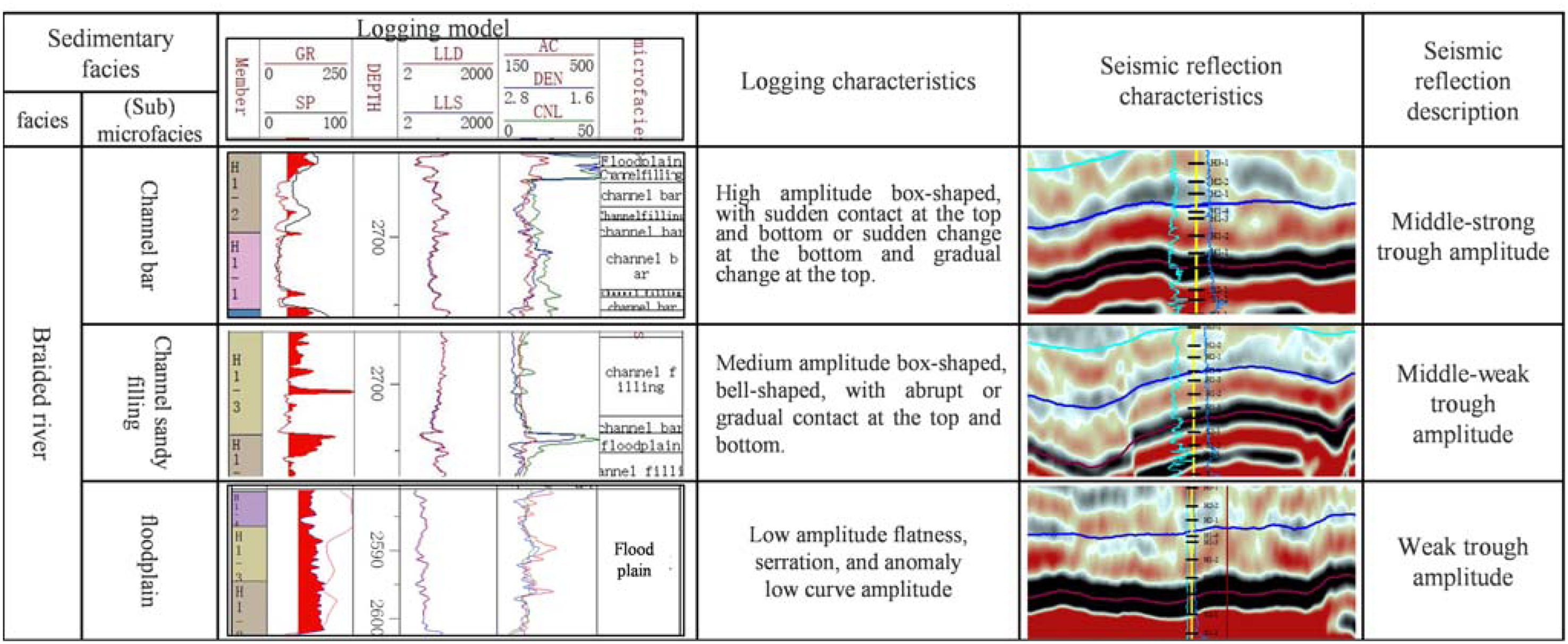
Integrated response model of logging and seismic facies corresponding to the sedimentary microfacies from the Xiashihezi Formation 1 Member in the study area.
The channel sandy filling microfacies were characterized by the presence of an erosion surface under scouring, the development of thin-layer glutenite channel lag deposits, and the gradual development of inclined bedding medium-fine sandstone facies upward (Figure 6(f) and (g)). This facies was distinguished by positive rhythmic deposition with a gradually finer grain size. It was evident that the channel sandy filling microfacies were the result of the gradual weakening of hydrodynamic forces, such as the diversion of the river or the dry season. The silt carried by the water flow was deposited in the river channel on both sides of the channel bar, resulting in a gradual thinning of the lithology. The corresponding natural gamma curve was characterized by a high medium amplitude toothed bell type (Figure 7).
The floodplain microfacies were characterized by a lithology of mudstone (Figure 6(h)), with the presence of deformation bedding in a limited area and the occasional occurrence of plant carbon debris in the section. The upper part of the vertical facies sequence was more developed, exhibiting thin parallel bedding, medium-fine sandstone lithofacies, swash bedding fine sandstone lithofacies, and wavy bedding siltstone lithofacies. The corresponding logging curve amplitude was markedly low, exhibiting the characteristics of low amplitude and straightness (Figure 7).
A logging-responsive model of sedimentary microfacies for the He1 Member could be constructed based on the sedimentary microfacies types and corresponding logging response characteristics. This model provided a basis for the analysis of sedimentary microfacies of a single well (Figure 7).
Characterization of sedimentary microfacies plane boundary of H1-1 sublayer
The identification and division of single-well sedimentary microfacies in the area were carried out using logging facies. The seismic facies were then calibrated using single-well facies according to the following procedure. To optimize the seismic attributes that best match the single-well sedimentary microfacies, a detailed calibration of single-well synthetic seismic records was undertaken. Additionally, a comparative analysis of the sedimentary microfacies of the He1 Member in the study area was conducted (Li et al., 2016, 2020). In the seismic profile corresponding to the sedimentary microfacies correlation of the connected well, three types of sedimentary microfacies could be identified in the seismic facies reflection. The channel bar microfacies were characterized by a strong trough amplitude short axis reflection (Figures 7 and 8(a)), which was the response characteristic of the strong acoustic impedance reflection interface formed by the channel bar sandstone body and the underlying mudstone. The floodplain microfacies were discontinuous weak trough amplitude seismic facies, primarily composed of mudstone, sandstone, and thin interbeds of mudstone and other sedimentary combinations with low hydrodynamic energy (Li et al., 2020). The channel sandy filling microfacies were primarily medium weak trough, medium short axis reflection seismic facies (Figures 7 and 8(a)). The correlation of sedimentary microfacies in the connected well profile was completed by taking full advantage of the high lateral resolution of 3D seismic data and analyzing the response characteristics of the above sedimentary microfacies on the seismic profile (Figure 8) (Li et al., 2020). The results indicated that the initial to intermediate stage of the He1 Member in the study area was characterized by braided river channel sandy filling and channel bar deposition, while the subsequent stage exhibited the emergence of muddy deposition in the floodplain. This suggests that the energy of the sedimentary water body generally diminished in an upward direction (Figure 8(b)). Among these, the H1-1 sublayer was notable for its substantial sandstone body thickness, developed reservoir, and relatively stable distribution, making it the primary target sublayer (Figure 8(b)).
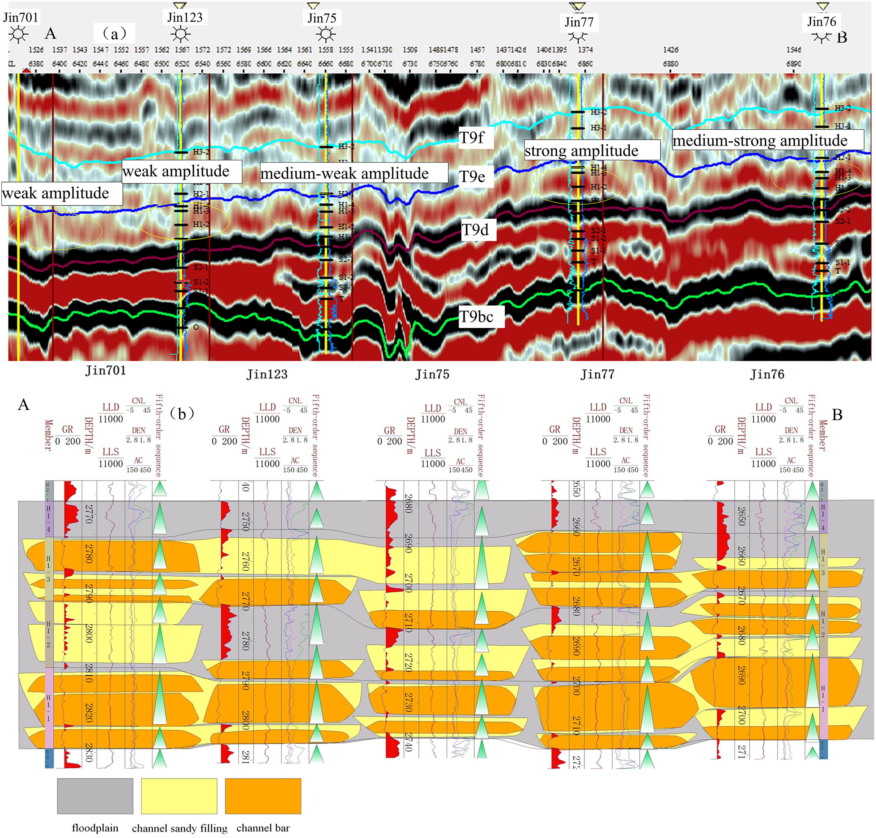
Correlation of crossing wells seismic profiles and sedimentary microfacies from the Xiashihezi Formation 1 Member of the Jin77 well block (see Figure 1A and B for profile lines).
The distribution and superimposition of channel sandstone bodies in the He1 Member of the study area were complex. The continuity of the channel bar was poor, and the average well spacing was > 5–10 km. For the study area with large well spacing, it was difficult to accurately describe the plane boundary of microfacies using only well data. Therefore, it was necessary to carry out a plane distribution analysis of sedimentary microfacies combined with well seismic. The relationship between sandstone body thickness and the maximum trough amplitude attribute of the target layer in the study area and adjacent areas was statistically analyzed based on the above well seismic fine calibration results. It was found that sandstone body thickness had a positive correlation with the maximum trough amplitude attribute value in the He1 Member (Figure 9(a)), providing a basis for determining the channel sandstone body boundary. Furthermore, the maximum trough amplitude values of different depositional microfacies were quantified, and the attribute relationship between sedimentary microfacies and trough amplitude (Figure 9(b)) was delineated to determine the amplitude value interval of corresponding sedimentary microfacies. The results indicated that the maximum trough amplitude was above 2500, and the channel bar microfacies were predominantly developed, with a lithology primarily consisting of gravel coarse sandstone. The value was distributed in the range of 1250–2500, with the medium-fine sandstone of channel sandy filling microfacies being developed. Conversely, a value below 1250 indicated the deposition of mudstone floodplain (Figure 9(b)). It could be observed that the correlation between the maximum trough amplitude attribute and sandstone body thickness could be employed to reflect the relative content of sandstone and mudstone, thereby enabling the detailed description of channel morphology and boundaries. Furthermore, the boundary characterization of sedimentary microfacies, such as channel bars and channel sandy fillings, could be completed according to different threshold values of maximum trough amplitude (Chen et al., 2019; Han et al., 2007; Li et al., 2020; Zeng and Ambrose, 2001). Therefore, in less well-studied areas, this study employed the maximum trough amplitude attribute of the target layer as a constraint to facilitate the detailed characterization of the plane distribution of sedimentary microfacies.
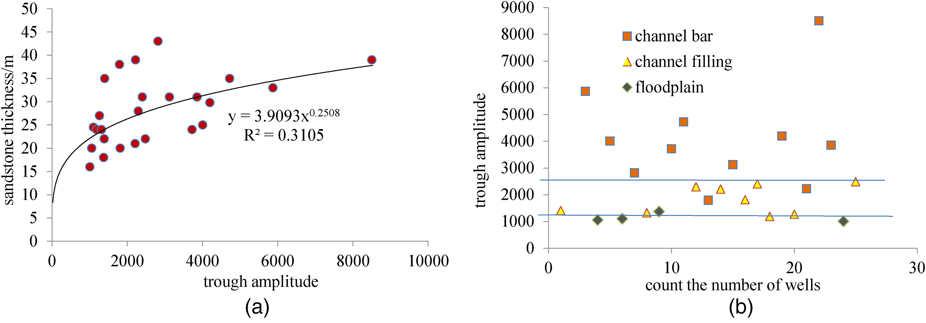
The relationship of the maximum wave trough amplitude with channel sandstone body thickness (a), and sedimentary microfacies (b) in the He1 Member of the study area.
The key objective of extracting objective sublayer seismic attributes is to obtain information on the seismic isochronous surface. This is achieved by resolving the longitudinal contact of different sandstone bodies and transverse “time crossing” and obtaining the plane distribution image of sedimentation (Gui et al., 2020). Currently, the most commonly used methods for reflecting the plane seismic attributes of sedimentary bodies are time slice, horizontal slice, and stratigraphic slice. In comparison to the time slice and horizontal slice, the stratigraphic slice is more closely aligned with the seismic attributes extracted from the geological age interface (isochronous interface) (Gui et al., 2020; Zhu et al., 2019). This is a crucial aspect in optimizing the stratigraphic slicing technology, as it allows for the selection of a reference seismic event with clear geological age interface significance (Gui et al., 2020). The seismic wave sets T9e and T9d represent the top and bottom interfaces of the He1 Member, respectively. The seismic reflection characteristics of the bottom interface T9d are particularly stable, with clear geological age significance. It serves as the regional standard reflector and has the property of a relative isochronous surface (Gui et al., 2020; Zhu et al., 2019). It is also close to the H1-1 sublayer, which has relatively stable stratum development in the study area. By interpreting the horizon based on the high-frequency sequence framework, the sedimentary microfacies of this layer can be effectively reflected through the extraction of the attributes of the stratigraphic slice of the target sublayer, combined with the sedimentary environment characteristics and logging interpretation results in the study area (Gui et al., 2020). This method allows for a more accurate reflection of the geomorphic characteristics of common sedimentary systems while tracking isochronous geological interfaces (Zhu et al., 2019).
In conclusion, the constraints of the high-frequency sequence framework and the fine correlation of the sublayers, together with the consistency analysis between the well horizon and the seismic horizon, indicated that the seismic trough amplitude attribute profile was consistent with the lithologic profile by a 90-degree phase conversion of the original seismic data (Figure 10). The maximum trough amplitude of the target sublayer H1-1 was extracted from the stratigraphic slice using the stratigraphic slice attribute extraction technology. This allowed for a clearer and more targeted extraction of the geological significance of the attribute. Furthermore, the distribution of sedimentary microfacies was constrained by the plane distribution of the maximum trough amplitude attribute of the H1-1 sublayer (Figure 11(a)). The plane distribution of sedimentary microfacies of the H1-1 sublayer in the study area was described in detail using the multidimensional interactive research method (Li et al., 2020). The results of the plane microfacies distribution (Figure 11(b)) indicated the development of four to five braided channels in the H1-1 sublayer, distributed in a north-south direction. The width of these channels was primarily between 1.5 and 6.5 km, with the west and north channels appearing to be particularly conducive to the development of channel bars.
Stratigraphic slice characteristics of 0° phase (a) and converted 90° phase (a) seismic profile in the East-West direction from Jin77 well block (see Figure 1A and B for profile lines).
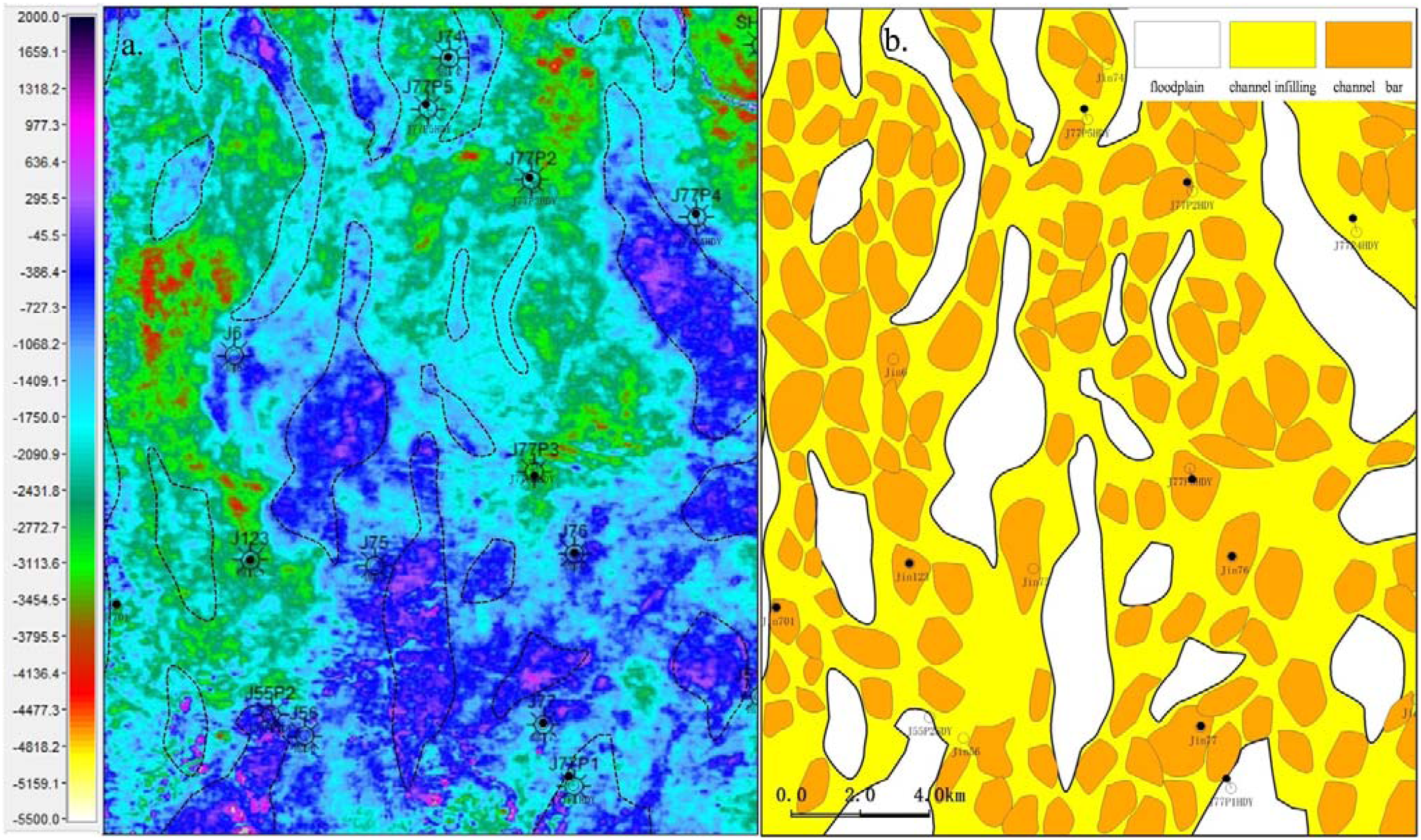
Planar distribution of seismic slice attribute (a) and sedimentary microfacies (b) of the H1-1 sublayer in the study area.
Conclusions
The He1 Member in the Jin77 well block was composed of the ascending cycle system tract of the third-order sequence. Based on the distribution of the fourth-order and fifth-order high-frequency sequences, it could be further divided into four sublayers. The main sandstone layer was distributed in the H1-1–H1-3 sublayers, with each sublayer being ∼ 15–20 m thick. The core log consistency calibration of the high-frequency sequence interface enabled the identification of the high-frequency sequence interface of the entire well section by analyzing the change in response characteristics of the logging curves. The combination of well and seismic data, step-by-step constraint, and utilization of the advantages of good horizontal continuity of seismic data were effective methods for solving the correlation between the high-frequency sequence and the sublayer of braided river multi-stage channel cutting superimposed strata.
The analysis of lithology, sedimentary structure, sedimentary facies signs, vertical combination, and sandstone body plane distribution of the He1 Member indicated that the target layer was mainly composed of wandering braided river deposits with low accommodation space, sufficient provenance supply, and unstable river channels. The channel bar, channel sandy filling, and floodplain were the three main sedimentary microfacies. The main target sublayer H1-1 comprised approximately four to five braided river channels, which were distributed in a north-south direction. The width of these channels was typically between 1.5 and 6.5 km, with the west and north river channels being particularly conducive to the development of channel bar microfacies.
The lithofacies were used to calibrate the logging facies, which were then used to identify and divide the sedimentary microfacies of the target interval. The single well facies were then used to calibrate the seismic facies, optimize the sensitive seismic attributes, and conduct research on the vertical and horizontal distribution of sedimentary microfacies. The relatively high horizontal resolution of seismic data allowed for the extraction of the seismic attributes of the target sublayer slice, constrained by the high-frequency sequence framework and the relative isochronous surface. The plane distribution of sedimentary microfacies could be effectively determined through the multidimensional interactive research method and the integrated calibration and analysis of geology and geophysics.
Footnotes
Acknowledgements
We are grateful to editor-in-chief professor Yuzhuang Sun, associate editor(s), and reviewers for their effort in reviewing our paper and their positive suggestions.
Declaration of conflicting interests
The author(s) declared no potential conflicts of interest with respect to the research, authorship, and/or publication of this article.
Funding
The author(s) disclosed receipt of the following financial support for the research, authorship, and/or publication of this article: Financial support of this study by the Ministry of Science and Technology of Sinopec project “Research on the Development Potential of Dense and High Water-bearing Gas Reservoirs in Dongsheng Gas Field” (P23133) and National Major Special Project “Development of Large Oil and Gas Fields and Coalbed Methane” (No. 2016ZX05002-006).