
Abstract
Germanium (Ge) is an excellent organophilic and dispersed semiconductor resource, which is irreplaceable in emerging industries such as new materials, new energy, aerospace, industrial smelting, national defense, military industry, and modern information technology, it has become an important direction of mineral resources exploration. Therefore, it is urgent to carry out research on the collaborative exploration model of coal and Ge deposits from a technical and economic perspective to lay a theoretical foundation for the collaborative exploration of coal and Ge. In this study, the Wulantuga coal–Ge deposit is taken as an example, according to the distribution characteristics of coal–Ge deposit and the response effect to the exploration technical means, the economical and effective exploration technical means, reasonable exploration project layout and resource estimation parameters of coal–Ge deposit are put forward, and the cooperative exploration mode of coal–Ge deposit is determined, it provides an important scientific basis for improving the strategic coordination ability of Ge mineral resources.
Keywords
Introduction
Germanium (Ge) is a typical dispersive element with stable abundance variation in the crust, and it has the characteristics of lithophilic, ferrophilic and organophilic (Huang et al., 2007; Jiu et al., 2021). Ge is an important semiconductor material, with a high infrared refractive index, low optical properties and excellent mechanical properties, it is used to prepare nuclear fuel elements and alloy with many metals to improve the hardness, strength and corrosion resistance of the alloy, so Ge is widely used in new materials, new energy and industrial smelting and other important fields (Gupta et al., 2023; Tayaba et al., 2023; Zhai et al., 2019; Wang et al., 2023a). Ge-containing fiber is the only fiber in engineering application at present, and it is also the main body of optical communication network. At the same time, Ge as an infrared optical material is suitable for military and major civil thermal imager and infrared radar. Ge is also considered to have anti-inflammatory, antiviral and anti-tumor effects in medical and health fields. Ge is a strategic metal designed to protect national economic security and military security, and is a necessary material for the preparation of high-tech products. In addition to the above applications, Ge is also widely used in solar cells, polymerization catalysts, information communication, bioscience and high-tech energy and other fields. Wulantuga is a super-large Ge deposit found in coal, which occupies a great advantage in resource reserves. Ge has a very important application potential in the strategic information industry in the future, the contribution of the information of Wulantuga coal–Ge deposit to the strategic coordination ability of Ge mineral resources is mainly reflected in the production of chips, solar cells, sensors, light filters and other industries.
With the rapid development of modern industry, the demand for Ge is gradually increasing, and there is a high risk of supply restriction. Therefore, it's of great significance to find and develop Ge mineral resources to ensure national security (Zhai et al., 2019; Dai et al., 2012a, 2015). Coal has become an important raw material for industrial extraction of Ge in many countries, Ge extraction address the gap related to the mobility and dispersion of Ge in the Earth's crust (Kumar et al., 2023; Seredin and Finkelman, 2008; Dai et al., 2014; Huang et al., 2007; Dai and Finkelman, 2018; Vyalov et al., 2020, 2021; H¨oll et al., 2007; Seredin et al., 2013). Countries around the world focus on the origin, distribution and the importance of Ge. Coal is a special sedimentary organic mineral which enrich strategic metals after special geological and geochemical conditions during its formation (Qin et al., 2015; Hao et al., 2023; Gopinathan et al., 2022a, 2022b, 2022c; Nath et al., 2023; Santosh et al., 2023; Wei et al., 2020, 2022), which is comparable to traditional metal deposits in abundance and forms large or super-large deposits in scale (Seredin and Finkelman, 2008; Sun et al., 2016; Dai and Finkelman, 2018), so it becomes an important supplement to traditional metal deposits. It is very important to study the cooperative exploration model of coal and Ge deposits to ensure the safe supply of Ge mineral resources and develop a circular economy.
Under certain geological and geochemical conditions, Ge is abnormally enriched and large deposits are formed, the discovery of the Wulantuga super-large deposit in the Shengli coalfield of Inner Mongolia in recent years has attracted the attention of experts on Ge in coal and related research. Researchers have summarized the occurrence state of Ge in coal, and believed that the organic affinity of Ge was strong, most of Ge in coal occurs in organic matter (Qi et al., 2007a, 2007b; Li et al., 2011a; Hower et al., 2002; Yudovich, 2003, 2004; Huang et al., 2008; Jiu et al., 2021; Du et al., 2004; Wei and Rimmer 2017; Liu et al., 2021; Etschmann et al., 2017; Shen et al., 2023), and a small part occurs in Ge-containing minerals (Zhuang et al., 2006). The enrichment of the Wulantuga Ge deposit is the main source of Ge provided by the adjacent granite hydrothermal solution. Coal is an extremely favorable place for Ge mineralization, and its humus is easy to fix the Ge in the surrounding solution (Zhuang et al., 2006; Qi et al., 2007a; Du et al., 2009; Dai et al., 2012b, 2015). The Wulantuga coal–Ge deposit is located at the edge of the fault depression basin, and the stagnant swamp environment with insufficient hydrodynamic supply, weak groundwater influence and strong reduction promotes the enrichment of Ge in coal (Du et al., 2003, Huang et al., 2008).
The dispersion and trace of strategic metal elements in coal-bearing strata and the characteristics of symbiotic co-existence with coal determine that it is difficult to explore and develop as an independent mineral. Therefore, the cooperative exploration of coal and strategic metal resources in coal-bearing strata is a theoretical, economical and technically feasible way. At present, the technology and method system of coal resources exploration has been relatively mature and combined with the exploration project practice, a new technology system of coal resources comprehensive exploration has been proposed, and corresponding exploration modes such as the combination of exploration means, exploration procedures and exploration project layout have been established (Xu et al., 2009; Cao et al., 2011; Wei et al., 2014). Some researchers have discussed the technical methods of comprehensive exploration/cooperative exploration of coal-bearing minerals, and proposed corresponding collaborative exploration methods according to the metallogenic background, characteristics, occurrence characteristics and other cooperative exploration areas of multi-energy minerals in the Ordos Basin (Yang et al., 2010; Wang et al., 2014). At the same time, from the two aspects of the coordination of multi-mineral exploration and various exploration technologies, the basic ideas and technical framework of the cooperative exploration of different strategic metal minerals of coal and coal measures are put forward (Li et al., 2011b, 2018; Wei et al., 2023, Cao et al., 2024; Zhang et al., 2024), and stressed that while paying attention to coal, strengthening the research on the accumulation law of multi-mineral resources and various resources in the whole coal measure (Wang et al., 2020, 2023b; Li et al., 2024).
However, researchers have not studied the cooperative exploration model of coal–Ge deposits, so this study takes the Wulantuga coal–Ge deposit as an example to analyze the distribution characteristics, review and optimizate the original exploration technology, exploration engineering layout and resource estimation, and then the collaborative exploration model of coal–Ge deposits is proposed. The Wulantuga Ge deposit is a very large Ge deposit found in coal seam with obvious enrichment law. The establishment of the cooperative exploration model of the Wulantuga coal–Ge deposit is expected to provide a theoretical basis for the cooperative exploration of coal–Ge deposits in China, and is a prerequisite for realizing the transformation of Ge element from coal measures to Ge minerals. It is of great significance to realize the accumulation, resource evaluation, development and utilization of strategic metal minerals in coal measures.
Geological background and methodology
Shengli coalfield
The Wulantuga coal–Ge deposit is located at the southwest end of the Shengli coalfield (Figure 1(a)). Shengli coal basin is an early Cretaceous fault basin in the Unite depression at the eastern end of the Erlian Basin group in the western foot of the Greater Hinggan Mountains, where the Bayanhua Group coal-bearing strata were deposited. The formation and development of the basin were controlled by Ft1 and Ft2 normal faults located on both sides of the basin margin (Figure 1(b)), graben-type faulted basins formed by have been recharged by clastic sources for a long time, and huge thick coal-bearing strata have been deposited (Huang et al., 2008). The interior of Shengli Coalfield is a wide and gentle syncline structure, with the overall direction of the synclinal axis from NE to SW, and the strata are flat and undulating (Zhuang et al., 2006).
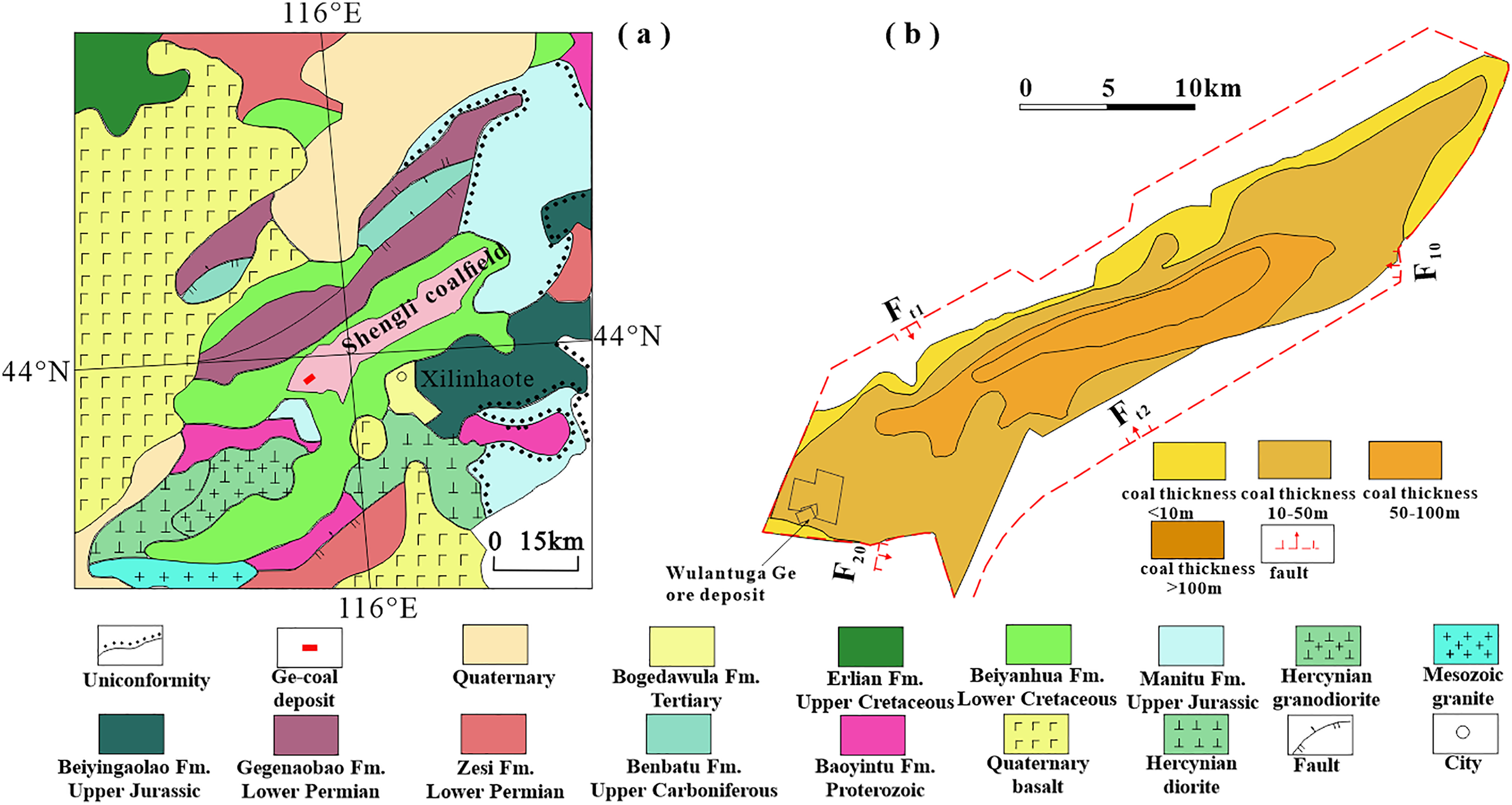
Geological background (a) and basin structure (b) of the Wulantuga coal–Ge deposit (modified after Wang, 1999; Dai et al., 2012b).
Wulantuga coal–Ge deposit
The Wulantuga coal–Ge deposit area is covered by Quaternary loess and aeolian sand, and the outcrop strata in the area include Lower Cretaceous Bayanhua Group (K1b) and Cenozoic group (Q) from old to new (Du et al., 2009). The main coal-bearing strata in this area are the upper 6, 6-1, 6-2 coal seams in Saihantala Formation (K1bs) of the Lower Cretaceous Bayanhua Group, the upper 6 and 6-2 coal seams that are locally occurring and sporadically recoverable, and 6-1 coal seams that are distributed in the whole area and have stable bedding, which are symbiotically associated with Ge ore and are the main ore-bearing layers. The occurrence of strata in the mine area is relatively gentle, slightly inclined to the northwest, with a dip Angle is less than 5°. It is a near-horizontal to slightly inclined monoclinal structure with developed faults and medium structural complexity. There are two normal faults Ft1 on the east and west sides, and Ft2 disrupts the continuous distribution of the 6-1 coal seam and Ge deposit (Miao et al., 2017).
Research methodology
A comprehensive analysis of the geological data in the study area, this paper is based on relevant standards such as specifications for coal exploration, specifications for rare metal mineral exploration, classification for Ge in coal, guidance for utilization and classification of content of valuable elements in coal, referenced to the original survey on the approval of detailed inspection of industrial indicators of Ge ore in Wulantuga mine II mining area, Xilingol League, Inner Mongolia. The exploration technical means and the layout of the exploration project are analyzed according to the actual situation of the site. The Wulantuga coal–Ge deposit is taken as an example, the technical method is tracked, the exploration project is arranged, and the technical means and the exploration project layout are reviewed and compared. The main method is to extract Ge through petrogeochemistry technology to find out the occurrence and change of Ge grade. In different exploration stages, follow the principle of targeted and progressive, collect coal samples, and test the Ge grade of each sample.
Distribution characteristics of coal–Ge deposits
The Wulantuga Ge deposit is a very large Ge deposit found in the coal seam, and the enrichment law is obvious. The Ge content on the plane shows a gradual decrease from southwest to northeast, while the coal seam thickness changes in the opposite trend, and the coal seam thickness shows a gradual thickening from southwest to northeast. Vertical Ge content is not evenly distributed in the coal seam, and there are enrichment in the top, middle and bottom of the coal seam.
Coal seams
Shengli Coalfield is a Mesozoic Early Cretaceous coalfield, the Bayanhua Group (K1b) is a set of continental coal-bearing formations thousands of meters thick, which is deposited in the giant fault basins of the Cathaysian system. The Tengger Formation and Saihantala Formation are developed in the Beiyanhua Group in the Shengli coalfield basin. The upper 6, 6-1 and 6-2 coal seams of the Wulantuga coal–Ge deposit are lignite in the upper coal section of the lower part of the Saihantala Formation. 6-1 coal seam is the main ore-bearing layer of the Ge deposit, which exists in the whole region. The buried depth is 4.25–150.60 m, and the thickness of the coal seam is 0.82–32.32 m, with an average value is 14.02 m, it gradually thickens from southwest to northeast (Figure 2).
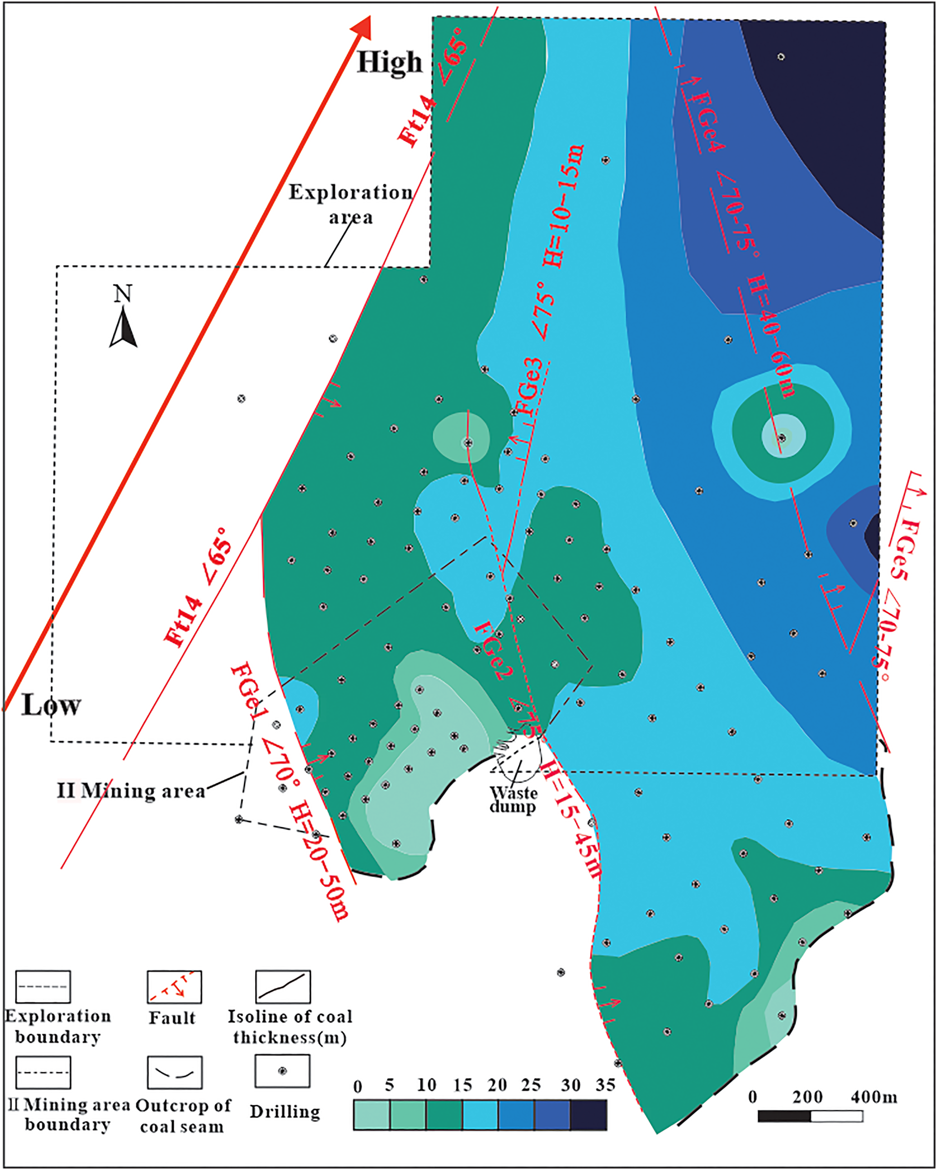
6-1 coal seam distribution of Wulantuga coal–Ge deposit.
Plane of Ge deposit
The Wulantuga Ge deposit is mainly hosted in the 6-1 coal seam in the area and is symbiotic with the coal seam. Ge content in coal is unevenly distributed and gradually changes in a certain direction. On the plane, Ge content ranges from 1 to 820 μg/g, with an average value of 133 μg/g, which gradually decreases from southwest to northeast (Figure 3). In the southwest corner of the study area, the Ge content in the open pit area is above 400 μg/g. The average Ge content outside the boundary of the II mining area in the northwest is between 101 and 147 μg/g.
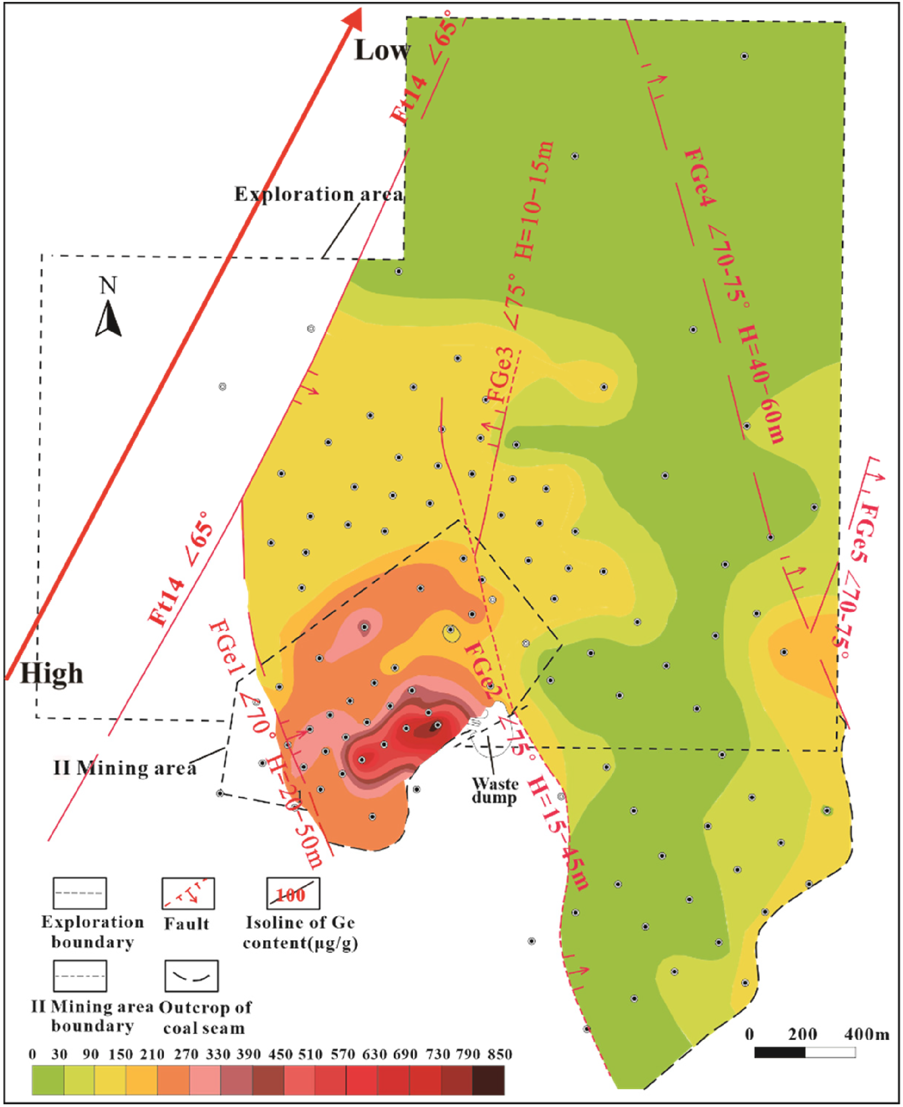
Ge content in Wulantuga coal–Ge deposit.
The Ge grade of the layers in the area changes greatly, and the Ge layer reaching the cut-off grade (Ge = 30 μg/g) has a smaller distribution range than that of the 6-1 coal seam. The Ge grade reaching the cut-off grade in the Ge layer ranges from 30 to 820 μg/g, with an average of 187 μg/g, as the content of Ge reaching the cut-off grade gradually decreases from southwest to northeast (Figure 4(a)). The Wulantuga coal–Ge deposit shows a continuous distribution of layers on the plane, and the horizon is relatively stable, with the coal seam slightly inclined to the northwest. The thickness of the layer reaching the cut-off grade is 0.55–16.6 m, with an average of 9.74 m, which is thicker in the southwest and southeast of the study area, and thinner in the northwest (Figure 4(b)). The law is obvious and the shape is simple, Ge content at the top and bottom of the coal seam is low and has no industrial value.
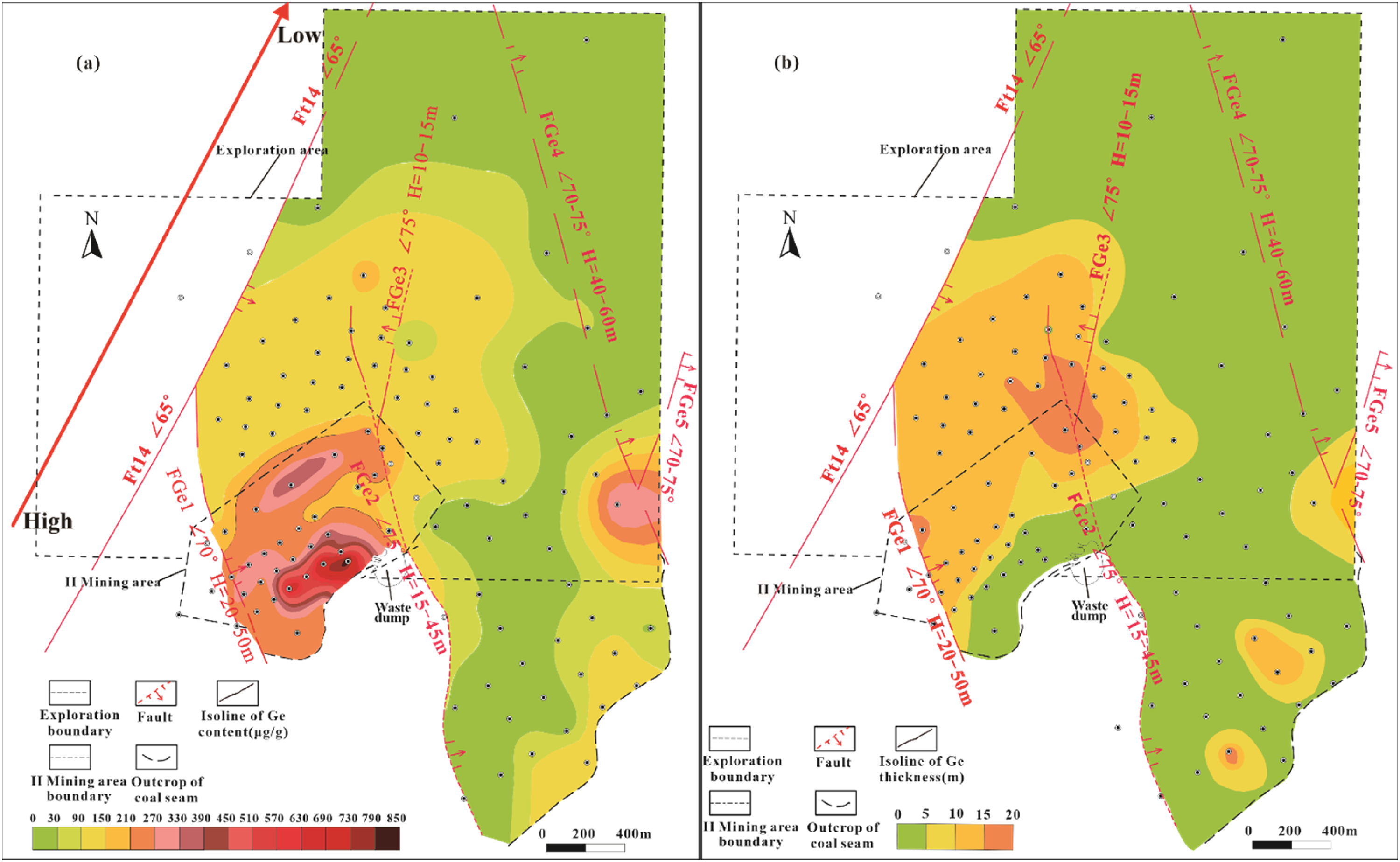
Ge content (a) and Ge layer thickness (b) at the cut-off grade (Ge=30μg/g) in the Wulantuga coal–Ge deposit.
Vertical direction of Ge deposit
The structure of the 6-1 coal seam is simple and the change of coal rock and coal quality is little. The vertical variation of Ge content in 6-1 coal seam of 78 boreholes is calculated. There are four types of Ge content: gentle type, unimodal type, bimodal type and trimodal type, and the peak mainly appears at the top, middle and bottom of coal seam, but the distribution of different peak types is not uniform and mutation in space, and there is no obvious regularity. The content of Ge in the same coal seam or different layers of coal seam with adjacent boreholes is different. The weighted average Ge content in the borehole of the IV exploration line in the northeast direction has great mutability (Figure 5), borehole 403 is 101 μg/g, and adjacent borehole K11 is only 3 μg/g, and variation of Ge content in borehole is large. The distribution of Ge content in different layers of the same coal seam in the K18 borehole is uneven and the vertical change is significant.
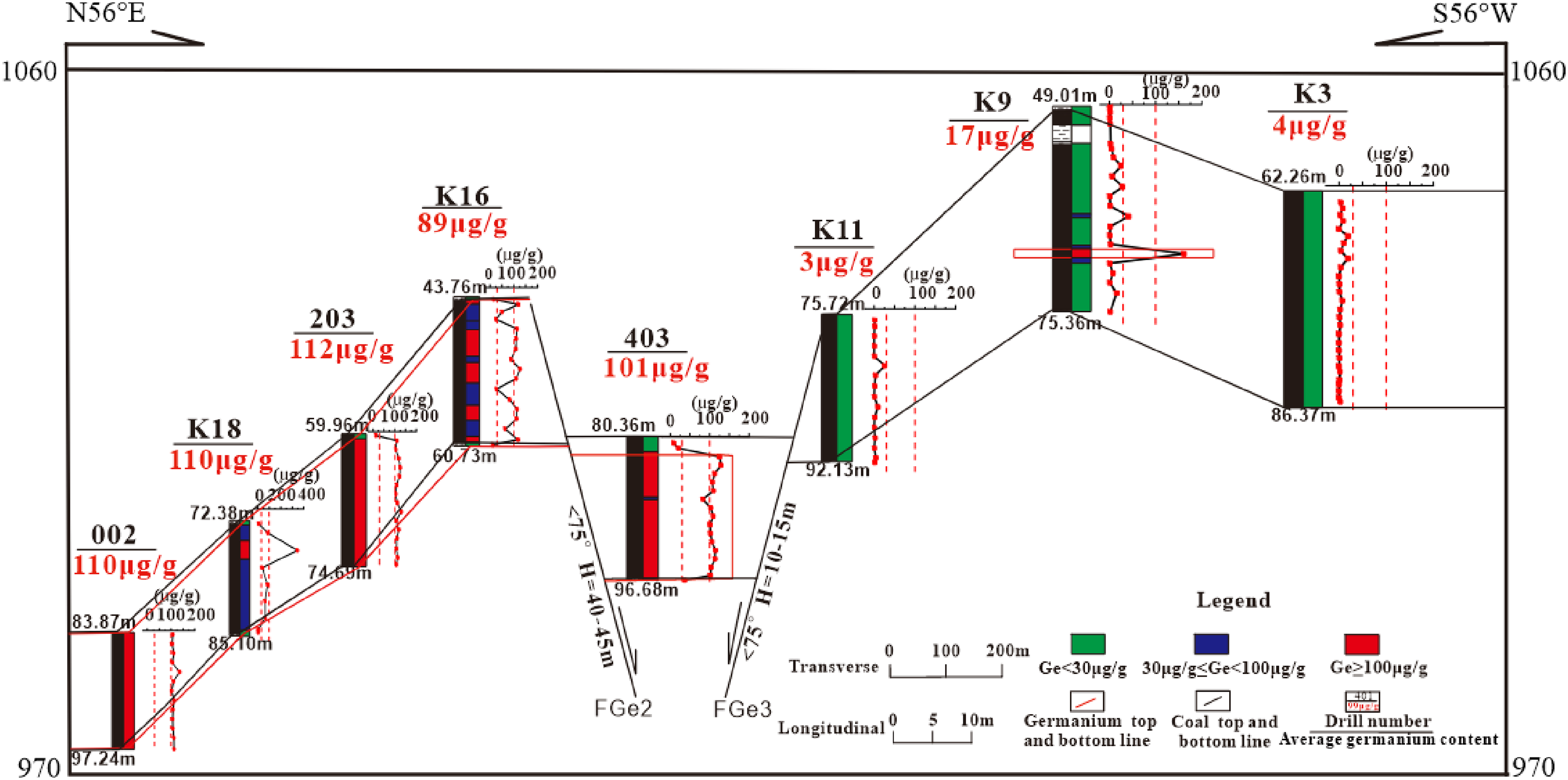
Distribution characteristics of Ge content in exploration line section IV.
Enrichment genesis of Wulantuga coal–Ge deposit
Researchers have analyzed the Ge deposit in Shengli Coalfield and found that the formation of Ge-rich coal requires abundant Ge sources and a suitable sedimentary environment (Zhuang et al., 2006; Huang et al., 2007). The main source of Ge was provided through the granite at the edge of the basin, which formed a Ge-rich solution under the repeated leaching of hydrothermal fluid and entered the peat bog, where it was adsorbed by organic matter and formed the enrichment of Ge in coal (Dai et al., 2012b). The basin is a fault-depression margin deposit, favorable topography and hydrogeological conditions make Ge-containing hydrothermal fluid flow into the coal-forming basin, and a stagnant swamp environment with strong reduction promotes the enrichment of Ge in coal (Huang et al., 2008; Du et al., 2004). Huang et al. (2007) concluded that the granite at the edge of the basin is the main source of Ge. The uneven vertical distribution of Ge content in the Wulantuga coal–Ge deposit is caused by the fluctuation of Ge enrichment in coal seam due to the change of the sedimentary environment and geological structure in the basin (Du et al., 2004; Huang et al., 2007). The fault zone of the Wulantuga coal–Ge deposit is developed on the edge of the basin, which provides a channel for hydrothermal circulation from the surface to the deep. The syngenetic faults that control the basin pattern not only affect the thickness of the coal seam, but also ultimately affect the distribution characteristics of the coal–Ge deposit (Dai et al., 2012b, 2015).
The metallogenic model of the Wulantuga coal–Ge deposit was proposed by researchers based on the content, distribution characteristics, occurrence state and geological origin of germanium in the Wulantuga coal–Germanium deposit (Figure 6) (Dai et al., 2015). During the period of peat accumulation, atmospheric precipitation circulated repeatedly through the ground, the granite in the southwest of the basin was subjected to leaching for a long time, forming a Ge-rich solution, which migrated along the groundwater to the edge of the basin, and was adsorbed and enriched by the peat at the edge of the basin. The peat in this part hindered and screened the further migration of the Ge-rich solution into the interior of the basin. After the Ge in the Ge-rich solution was adsorbed by peat, the concentration of Ge decreased and continued to migrate into the basin. Finally, the Ge content in the coal seam gradually decreased from southwest to northeast.
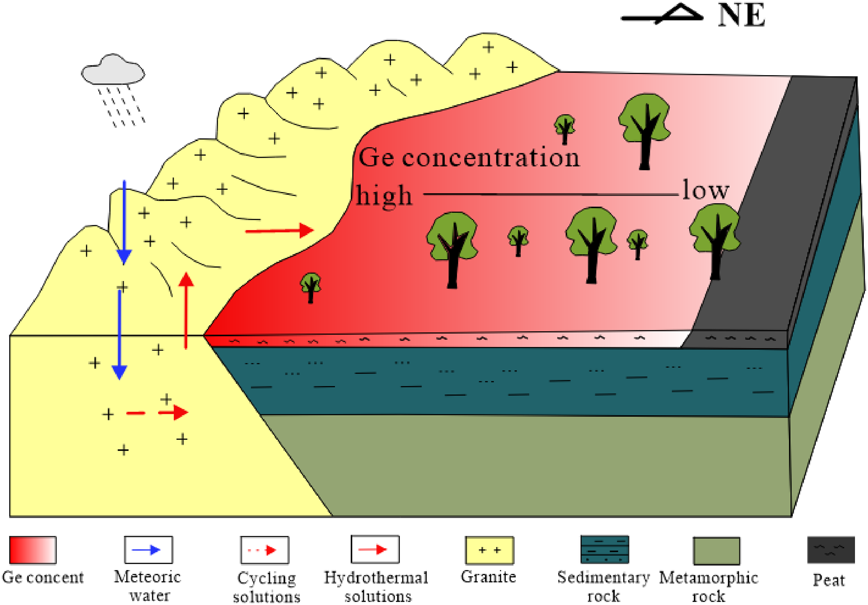
Formation models of coal-hosted Ge ore deposits in the Wulantuga (modified after Dai et al., 2015).
Collaborative exploration model of coal–Ge deposit
The exploration technical means, exploration project layout and resource estimation in the original exploration are described. On this basis, the technical means, exploration engineering layout and resource estimation parameters are reviewed. The method of petrogeochemistry sampling in the exploration technical means of the Wulantuga coal–Ge deposit is unreasonable, which violates the principle of economic rationality and gradual progress. The selection of geological mapping, drilling engineering and logging technology is more appropriate. In the original exploration, the layout of coal exploration engineering meets the line distance requirement of coal geological exploration standard, while the spacing of Ge exploration engineering violates the line distance requirement of the exploration standard. The classification of coal resources violates the requirements of the coal geological exploration standard.
The original report was further optimized for different exploration stages when adopting petrogeochemical exploration techniques, followed the principle of zoning, and divided into different blocks in the study area using different engineering layout schemes. For the optimization of resource parameters, the scope of 30–50 m on both sides of the fault was divided as inferred resource blocks according to the requirements of the code. And the potential resources between 30 μg/g ≤ Ge ≤ 100 μg/g are calculated. According to the geological, geochemical and geophysical conditions, a reasonable cooperative exploration model for coal and Ge minerals is established from the two aspects of the coordination of multi-mineral exploration and the coordination of various exploration technologies, and by the principle of maximizing economic benefits and optimizing exploration methods.
Original exploration technical means, exploration project layout and resource estimation
Exploration technical means
In the original exploration of Wulantuga coal–Ge deposit, the occurrence state, content and resources of coal and Ge deposit were ascertained using drilling, well logging, geological mapping, and petrogeochemistry.
Layout of exploration engineering
The square exploration network system was selected for the exploration layout, and the exploration line direction was arranged along the coal seam trend and inclination. The amount indicated resources of coal are defined by 800 × 800 m grid degree, and measured resources are defined by the 400 × 400 m net degree. The indicated resources of Ge were determined by 200 × 200 m grid between the exploration area and II mining area, and measured resources of Ge were determined by 200 × 200 m plus central borehole and 100 × 100 m grid.
Resource estimation
For the determination of Ge grade, the minimum minable boundary of Ge content in the plane was 100 μg/g in the original exploration, and the vertical Ge samples with Ge ≥ 30 μg/g were calculated by weighted average grade of a single project. The geological block method was used to estimate the resource reserves in the original exploration. The amount of coal and Ge resources were determined by parallel equidistant exploration coils with corresponding mesh.
Review the original exploration
Review of exploration technical means
The topographic geological mapping in the original exploration was reviewed. The exploration area is a vast grassland, the surface is covered by the quaternary system without bedrock exposure. Several normal faults were found in the exploration, so a simple hydrogeological mapping was carried out by supplementing the quaternary overburden. Therefore, it is more appropriate to choose topographic geological mapping in the original exploration.
The buried depth of coal seam in the exploration area is 26.80–150.60 m, and the drilling controls the coal and Ge layer well and the engineering amount is small, and the exploration cost is low compared with the earthquake. From the perspective of economic rationality, it is reasonable to choose drilling directly instead of seismic exploration in the original exploration, which better reflects the maximization of economic benefit and the optimization of exploration effect.
The shallow buried depth of coal seam in the exploration area is a typical full cover area, and it is more optimized to use drilling engineering technology to expose the coal and Ge layers, control the layers, sample collection and delineation of resources. Therefore, drilling engineering is the exploration technology that must be selected in the exploration.
In the general exploration, one full-layer sample was taken when the seam thickness was less than 3 m, and one sample was taken every 3 m when the seam thickness was more than 3 m, with individual samples up to 4 m, the Ge content of each sample was tested. In the detailed exploration, coal seam samples were taken every 1 m, and the Ge content of coal seam samples, coal seam top, bottom and dirt samples were tested. In the advanced exploration, one full layer sample was taken when the seam thickness was less than 3 m, and one sample was taken every 3 m when the seam thickness was more than 3 m. The sample collection length in the detailed exploration was longer than that in the advanced exploration, which violated the gradual improvement of the exploration accuracy in the three stages from general exploration to detailed exploration to advanced exploration, and the sample collection method did not follow the principle of economic rationality and gradual progress, which was obvious that the sampling method in the original survey was unreasonable.
The logging parameters were used to classify lithology, distinguish coal seam and qualitatively determine the thickness of coal seam. The logging curve reflects the different geophysical characteristics of coal and rock strata. The coal seam in the exploration area has obvious physical properties different from sandy mudstone, mudstone and siltstone, showing high resistivity, low density and low natural radioactivity, the sonic time difference is generally positive and abnormal. In the original exploration, the conventional parameters of coal logging were used to distinguish lithology and coal seam, but the response characteristics of Ge in various logging curves were not obvious. Because coal is the carrier of Ge, coal and Ge coexist, so the choice of logging technology and logging parameters in the original exploration is reasonable.
Review of the layout of exploration engineering
The original exploration determined that the structural complexity of the exploration area was of medium type according to Specifications for coal exploration, the main recoverable coal seam 6-1 was of stable type, and the coal exploration type was of class 2 and type 1. The measured resources are delineated by 400 × 400 m grid degree, the indicated resources are delineated by 800 × 800 m grid degree, and the inferred resources are delineated by sections larger than 800 × 800 m or controlled by only sparse drilling holes, which meet the line distance requirements of Specifications for coal exploration.
In the case that there is no standard to follow, the type of Ge exploration is determined to be type I by specifications for rare metal mineral exploration. and the layout of the original exploration project is detailed in section 5.1.2. The specifications for rare metal mineral exploration stipulate that when the exploration type is type I, the basic exploration project spacing along the strike is 160–200 m, and along the trend is 120–160 m to delineate the indicated resources. The spacing of exploration in the original report was not by the requirements of relevant specifications.
Review of resource estimation
In the original exploration, the lowest cut-off grade of Ge is 30 μg/g, and the lowest industrial grade is 100 μg/g. Ge grade greater than 20 μg/g is high Ge coal by the classification for Ge in coal. The minimum grade of Ge extracted from coal is 30 μg/g according to the guidance for utilization and classification of the content of valuable elements in coal. It is necessary to discuss whether it is reasonable to determine the cut-off grade and minimum industrial grade of Ge in the original exploration.
When calculating the average Ge grade in a single hole in the original exploration, the cut-off grade of 30 μg/g was used as the dividing standard, and all samples greater than 30 μg/g were included in the calculation of the average grade of the whole layer. The minimum minable boundary of Ge ore plane was determined by the minimum industrial grade of 100 μg/g. The inconsistencies in the vertical and plane grades lead to a large deviation in the estimated resource quantity.
The specifications for coal exploration stipulate that when delimiting measured and indicated resources blocks across large faults, a range of 30–50 m is divided on both sides of the fault as inferred resources. It is not allowed to delimit measured resources and indicated resources across faults when faults are dense. In the original exploration, the exploration network degree near the fault is classified as inferred resources, which violates the requirements of the resource level of the coal geological exploration standard.
Optimization of coal–Ge deposit collaborative exploration
Optimization of cooperative exploration technology means
According to the characteristics of the topography, surface, regional geological background, structure, coal seam and Ge layer of the Wulantuga coal–Ge deposit, the technical means of topographic geological mapping, drilling, geophysical logging and petrogeochemistry are used in coordination, and the technical means of petrogeochemistry exploration are optimized for different exploration stages, follow the principle of pertinence, step by step and economic rationality. In the general and detailed exploration, when the thickness of coal seam is less than 3 m, one full-layer sample is taken, and when the coal seam exceeds 3 m, one sample is taken for every 3 m, one coal sample is taken every 1 m in the advanced exploration.
Optimization of cooperative exploration project layout
In the cooperative exploration of coal and Ge mineral resources, the non-uniformity and mutability of metal element distribution are fully considered, and different engineering layouts are adopted in different blocks in the study area according to the principle of zoning. The layout system of the exploration engineering is determined according to the occurrence of coal-bearing strata, Ge content distribution and regional characteristics. The general exploration is a square exploration network system, and the detailed and advanced exploration is a rectangular exploration network system. The trend of coal seam and the variation of Ge content are analyzed comprehensively to determine the direction of the exploration line. The direction of the long side of the rectangular exploration network is northeast (coal seam and Ge deposit towards), and the direction of the short side is northwest (coal seam and Ge deposit trend).
The stability degree of coal seam in the exploration area is stable, the structural complexity is medium type, and the exploration type of coal is class 2 and type 1. The sum of the type coefficients of 5 geological parameters of Ge deposit is 2.9, and the exploration type of Ge deposit is type I. The exploration types of coal and Ge deposits are analyzed comprehensively, and the layout plan of coal–Ge deposit cooperative exploration project in the exploration area is determined. In the general exploration, the square survey network system 1600 × 1600 m was used to understand the coal seam and Ge, and the high Ge area was divided. In the detailed and advanced exploration, a rectangular exploration network was used to determine that the net degree of coal indicated resources was 800 × 600 m, and the net degree of coal measured resources was 400 × 300 m. The net degree of Ge indicated resources was 200 × 150 m, and the net degree of Ge measured resources was 100 × 75 m. The layout of coal and Ge exploration engineering meet the requirements of exploration standards.
Optimization of resource estimation
Based on the comprehensive analysis of previous research results, and referring to the specifications for coal exploration, specifications for rare metal mineral exploration stipulates, classification for Ge in coal, guidance for utilization and classification of content of valuable elements in coal and the determination of grade in the original exploration report, the minimum cut-off grade was selected as 30 μg/g, the minimum industrial grade is 100 μg/g for resource estimation. After optimization, the minimum estimated boundary on the Ge ore plane is 100 μg/g, and vertical samples ≥100 μg/g are used to calculate the average Ge grade in a single hole to estimate the resource amount. The Ge is bounded by 30 μg/g and 100 μg/g on the plane, and the Ge is bounded by 30 and 100 μg/g in the vertical calculation of the average Ge grade in a single hole, and the samples with 30 μg/g ≤ Ge ≤ 100 μg/g are used to calculate the average grade of the whole layer to determine the potential resources. The geological block method is used to estimate the coal and Ge resources. When the measured resources and indicated resource blocks are delimited across the fault, the range of 30–50 m is divided on both sides of the fault as the inferred resource blocks.
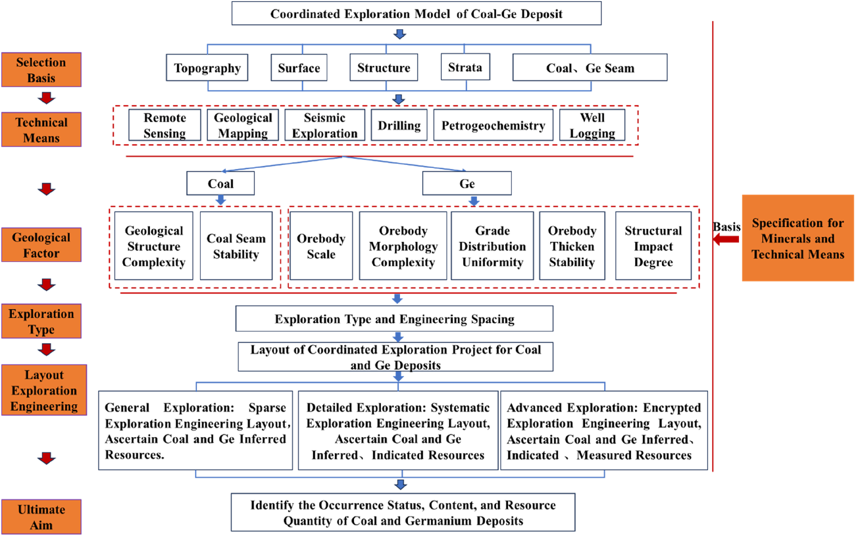
Coal–Ge deposit cooperative exploration model
Ge is difficult to explore and develop as an independent mineral because of its microtrace, dispersibility and co-existence with coal. It is a theoretical, economical and feasible way to carry out cooperative exploration of Ge minerals while coal mineral exploration. The distribution characteristics of the Wulantuga coal–Ge deposit and the effectiveness of its response to exploration technical means, the economical and effective exploration technical means, reasonable exploration project layout and determination of resource estimation parameters for coal–Ge deposit collaborative exploration are proposed. The collaborative exploration model of coal–Ge deposit is determined, which includes economical and effective technical means and reasonable exploration project layout (Figure 7). The cooperative exploration of coal–Ge deposits is based on the study of Ge enrichment metallogenic mechanism and occurrence law. The theoretical basis is based on interdisciplinary theories such as coal field geology, geochemistry, mineral deposit science, and exploration engineering. Technical means are collaborative exploration technologies composed of key technologies such as precision drilling, fine geophysical exploration, and fine geochemical exploration. The exploration engineering layout and resource estimation are reasonably carried out based on standards such as single mineral exploration specifications to achieve the collaborative exploration of coal and Ge minerals.
Coal–Ge deposit collaborative exploration model.
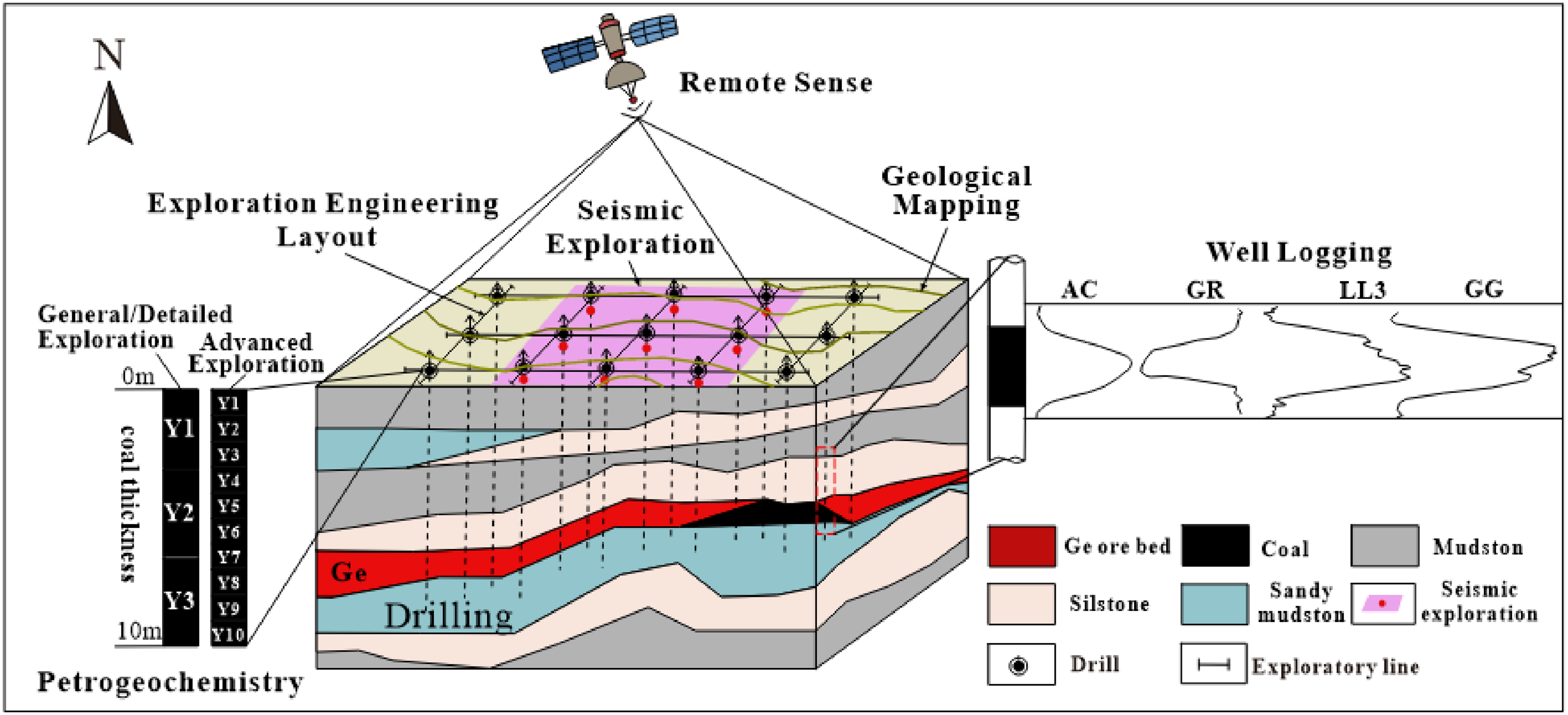
The process of coal–Ge deposit collaborative exploration model follows the principle of research first (Figure 8). Based on a comprehensive analysis of topography, surface, regional geological background, structure, coal seam and Ge ore layer, the collaborative application of economic and effective technical means such as remote sensing, geological mapping, drilling, logging technology, earthquake and petrogeochemistry are strengthened.
Flow chart of collaborative exploration model of coal–Ge deposit.
Through image interpretation and systematic analysis obtained by remote sensing technology, surface system analysis, observation of related structural cracks in underground coal fields, basic data of coal seam development are obtained, main geomorphic morphology is determined, lithologic combination types are divided and coal seam distribution is divided. The stratigraphic sequence, geological characteristics of coal-bearing strata, geological structure morphology, characteristics of coal seam and associated minerals are preliminarily ascertained by geological mapping. The drilling project revealed the ore-bearing strata of Ge minerals, the depth of borehole layout is 15∼20 m in the lower part of the ore layer. Well logging is performed in all boreholes in geological exploration, the selection of logging parameters is mainly to divide lithology, distinguish coal seam and qualitatively determine the thickness of coal seam. Seismic exploration is used to infer the nature and form of underground rock strata, find out its distribution range, horizon and other information. Petrogeochemistry is an important basis for the correct evaluation of mineral resources. It studies the content, occurrence state and resource amount of coal and Ge.
The stability of coal seams, complexity of geological structures and ore body size, complexity of ore body morphology, uniformity of distribution of main useful components, stability of thickness, and degree of structural influence are geological factors that determine the exploration types of coal and Ge minerals. A reasonable collaborative exploration engineering layout plan is proposed. The occurrence state, content and resource amount of coal and Ge deposits have been ascertained, it provides the geological basis for the comprehensive development and utilization of coal and Ge mineral resources.
Conclusions
The enrichment regularity of Wulantuga coal–Ge deposit is obvious. The Ge content in the plane gradually decreases from southwest to northeast, and the changing trend of coal seam thickness is opposite, which shows that the coal seam gradually becomes thicker from southwest to northeast. Vertical Ge content is not evenly distributed in the coal seam, and it is enrichment in the top, middle and bottom of the coal seam, the content of Ge in the roof and floor is low, while is rich in some parts.
Based on the distribution characteristics of coal and Ge in Wulantuga and the effectiveness of the response to the exploration technical means, the exploration technical means, the exploration engineering layout and the resource estimation of the original report are reviewed and optimized. The economic and effective exploration technology, reasonable exploration engineering layout and resource estimation parameters are determined, and the collaborative exploration model of coal–Ge deposit is determined.
The collaborative exploration model of coal–Ge deposits includes economical and effective technical means and reasonable exploration engineering. The research on the enrichment and mineralization mechanism and occurrence rule of Ge element is the prerequisite, the multi-disciplinary theories of coal geology, geochemistry, mineral deposit science and exploration engineering are the basis, the key technologies of precision drilling, fine geophysical exploration and fine geochemical exploration are the cooperative exploration means, and the standards of single mineral exploration norms and other standards are the working basis. The exploration project is reasonably arranged, and the resource quantity is estimated to achieve the goal of collaborative exploration of coal and Ge minerals.
Footnotes
Declaration of conflicting interests
The authors declared no potential conflicts of interest with respect to the research, authorship, and/or publication of this article.
Funding
The authors disclosed receipt of the following financial support for the research, authorship, and/or publication of this article: This work was supported by the National Key Research and Development Plan of China (2021YFC2902004), National Natural Science Foundation of China (42372187, 41972174).