
Abstract
The various types of reservoir space in carbonate reservoirs make the process of hydrocarbon migration and accumulation very complex. How to quantitatively characterize the characteristics of hydrocarbon migration and accumulation in carbonate reservoirs is one of the key problems for carbonate hydrocarbons exploration and exploitation. Taking the Ordovician in the Daniudi area of Ordos Basin as an example, three types of source rock-reservoir-cap assemblages, namely upper-generation assemblage, lateral variable assemblage, and self-generation-reservoir-cap assemblage, were determined by characterizing the forming elements of carbonate reservoirs. Petromod software is used to build a two-dimensional profile model, and vitrinite reflectance of source rock and porosity of the reservoir were used as correction parameters, and the hydrocarbon migration and accumulation process was simulated by the invasion percolation algorithm. It is confirmed that the Ordovician Majiagou formation in the study area has three periods of hydrocarbon charging and three periods of hydrocarbon adjustment. The hydrocarbon migration pathways in carbonate rocks include lateral contact in the pinch-out area, source rock-reservoir contact in the trough area, fault-connected, and source rock-reservoir superposition. The source rock-reservoir-cap assemblages of upper-generation assemblage and lateral variable assemblage correspond to the lateral contact in the pinch-out area, source rock-reservoir contact in the trough area, fault-connected, while self-generation-reservoir-cap assemblage corresponds to the fault-connected, and source rock-reservoir superposition. The high part of the structure and fault zone are the strongest structural deformation parts, whose fractures are relatively developed, controlling the location of hydrocarbon accumulation, meanwhile, the reservoir quality directly controls the degree of hydrocarbons saturation. The research results are beneficial to establish a more accurate quantitative evaluation method of hydrocarbon migration and accumulation in carbonate rocks and to understanding the controlling factors of hydrocarbon migration and accumulation in carbonate rocks.
Keywords
Introduction
Carbonate rock has always been a key field of hydrocarbons exploration and exploitation (Brigaud et al., 2014; Li et al., 2021; Wannier, 2009). Although carbonate rocks account for only about 20% of all sedimentary rocks, they contain more than half of the world's proven hydrocarbon reserves (Ahr, 2008; Deng et al., 2020; Jia, 2012). However, the process of sedimentation and diagenesis of carbonate reservoirs is very complex, which leads to the development of complex reservoir spaces such as pores, caves and fractures in carbonate reservoirs (Flügel and Munnecke, 2010; James and Jones, 2016; Liu et al., 2018; Moore and Wade, 2013; Wang et al., 2021). These reservoir spaces are also important pathways for hydrocarbon migration, resulting in a very complex process of hydrocarbon migration and accumulation. How to quantitatively characterize the characteristics of hydrocarbon migration and accumulation in carbonate rocks is one of the key problems for hydrocarbons exploration and exploitation.
Basin simulation is based on physical and chemical principles and geological processes, it could quantitatively simulate the formation and evolution of petroliferous basin, as well as the generation, migration, and accumulation of hydrocarbons (Shi, 2009a; Tissot and Welte, 1984) that plays an important role in modern hydrocarbons exploration, petroleum geology comprehensive research and hydrocarbons resource evaluation (Liu and Liu, 2017). Hantschel and Kauerauf (2009) and Shi (2009b) believe that basin simulation is a great progress in modern earth science and a popular means of quantitative research of petroleum geology, which can help geologists to understand hydrocarbons systems (Shi, 2009b; Wendebourg, 2003; Zhang et al., 2001). It can also be seen in practical applications that one-dimensional simulation is mostly used to analyze the thermal history and hydrocarbon maturity history of drilling wells, while two-dimensional (2D) and three-dimensional (3D) simulation related to hydrocarbon migration is relatively rare, which affects the quantitative analysis of the hydrocarbons accumulation process (Duran et al., 2013; Liu et al., 2016).
Basin simulation softwares such as PetroMod, TemisPack, and Trinity are often used for hydrocarbon migration and accumulation simulation (Guo et al., 2020; Liu and Liu, 2017), and the PetroMod simulation software is considered one of the most advanced of its kind, with the most extensive geological templates and empirical parameters, and a highly integrated, personalized operating interface.
PetroMod software has four petroleum migration modeling methods: Darcy flow, Flowpath, Hybrid (Darcy, Flowpath), and invasion percolation (IP). The Darcy flow method is suitable for simulating oil and gas migration in poorly permeable strata (Baur et al., 2011), while the Flowpath method is mainly applicable to the stratum with good permeability, it takes buoyancy as the main driving force and takes less time to calculate. The hybrid method is a combination of the Darcy flow method and Flowpath method, in which the Darcy flow method is used under low permeability conditions, while the Flowpath method is used under high permeability conditions (Liu and Liu, 2017). The IP method is suitable for simulating oil and gas migration under the condition of complex formation geometry and high mesh density. The simulated oil and gas migration is instantaneous and the calculation speed is fast (Carruthers, 1998), so the model of complex petrographic reservoirs with strong heterogeneity and large number of grids can be established to simulate the history of fluid charging, overflow and leakage (Kauerauf et al., 2016; Kleine et al., 2016). The basic rule of IP is the relationship between the resistance of oil and gas migration and the driving force. If the driving force is greater than the resistance, the oil and gas can migrate forward; otherwise, the migration will stop (Guo et al., 2020)
Compared with clastic rock-reservoir, carbonate reservoir has stronger heterogeneity, oil and gas transportation system leads to obvious differential migration and accumulation of oil and gas (Wang et al., 2010). Especially for complex superimposed basins, carbonate reservoir presents several periods of hydrocarbon migration, accumulation and adjustment, it is difficult to characterize hydrocarbon migration and accumulation. To illustrate the complex hydrocarbon migration and accumulation process in space, the aid of advanced basin numerical simulation technology is essential.
The Ordovician carbonate rock in Ordos Basin is an important hydrocarbons replacement area, but there are controversies about the hydrocarbon migration and accumulation process of Ordovician Majiagou formation. Daniudi area, located in the north of Ordos Basin, is an important hydrocarbon-producing area in the basin and has made a great breakthrough in the Ma5 member of the Ordovician Majiagou formation. The controlled reserve of Ma5_5 is 178 × 108 m3, and the test production effect of Ma5_6–10 is good, with daily gas production of 3 × 10⁴ m3/d per well (Lei et al., 2020), while the exploration degree of Ma4 to Ma1 is still low. The main purpose of this paper is that: based on describing the hydrocarbon accumulation factors of carbonate reservoir, Petromod software was used to establish a 2D profile model. And with vitrinite reflectance of source rock and reservoir porosity as model correction parameters, the IP hydrocarbon migration algorithm for complex reservoirs was used to accurately simulate the process of hydrocarbon migration and accumulation and to reveal the controlling factors of hydrocarbon migration and accumulation. The research results are of great significance for quantitative evaluation of hydrocarbon migration and accumulation process and understanding of controlling factors of hydrocarbon migration and accumulation in carbonate rocks.
Geological setting
Ordos Basin is located in the west of the North China Platform, extending across Shaanxi, Gansu, Ningxia, Inner Mongolia, and Shanxi provinces, covering an area of 37 × 104 km2. Daniudi area is in the northern of Ordos Basin and the northern of Yishan slope, covering an area of about 2000 km2 (Figure 1(a) and (b)). It is a gentle uplift in the direction of northeast–southwest (Bai, 2016). It has a low structure in the west and a high structure in the east, and many faults are developed but with short extension lengths (Figure 1(c)).
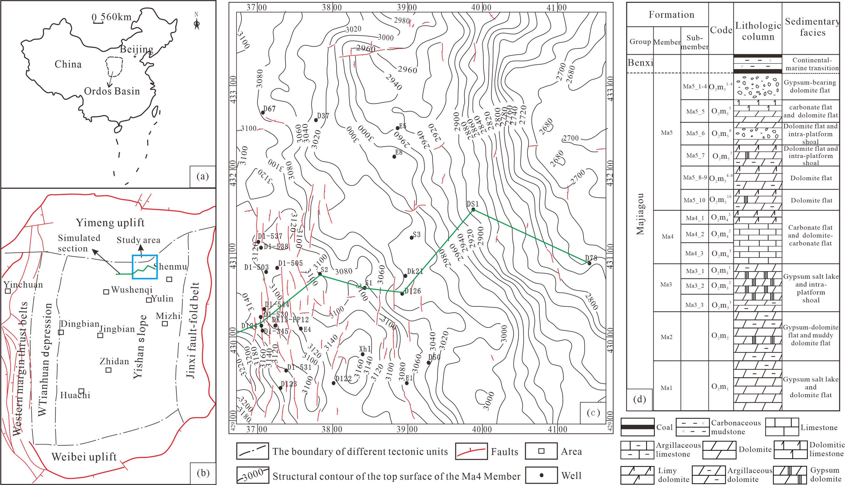
Tectonic location of Daniudi area in Ordos Basin (a, b), structural characteristics of the top surface of the Ma4 (c), and stratigraphic distribution in Benxi formation and Ordovician Majiagou formation (d).
Majiagou formation in Ordos Basin is a set of carbonate rocks with evaporites (Feng and Bao, 1999; Fu et al., 2017; Zhao et al., 2015). The sedimentation of Majiagou formation has three large-scale transgression and regression cycles. The transgression period is dominated by open platform deposits, while the regressive period is dominated by confined platform deposits and evaporative platform deposits (Feng and Bao, 1999; Fu et al., 2017). From bottom to top, Majiagou formation in Ordos Basin can be divided into six members from Ma1 to Ma6. Ma1, Ma3, and Ma5 members were deposited in large-scale regressive period. The rock types are mainly microcrystalline dolomite with gypsum-salt rock, and Ma5 member is subdivided into 10 sub-members from Ma5_1 to Ma5_10 from top to bottom (Bai, 2016), and Ma3 member is subdivided into three sub-members from Ma3_1 to Ma3_3 from top to bottom. Ma2, Ma4, and Ma6 members were deposited in the period of large-scale transgression and mainly deposited limestone (Bao et al., 2017; Fu et al., 2017). Ma4 member is subdivided into three sub-members from Ma4_1 to Ma4_3 from top to bottom. Dolomite is mainly developed in Ma2, and Ma6 is absent due to denudation. The Carboniferous—Permian Benxi Formation—Shanxi Formation is dominated by weathered bauxite, coal rock and coal measure claystone in continental—marine transitional facies (Figure 1(d)).
Data and methods
Data and samples analyses
Source rock, reservoir, well, and seismic data were collected from Petro China Huabei Oil Field Company. The source rock data collected include organic carbon, pyrolysis S1 + S2, organic matter type, and bitumen reflectance (Rb) of Carboniferous and Majiagou formation source rocks. We use these data to analyze the basic characteristics of source rocks in the Carboniferous and Majiagou formations. The bitumen reflectance was calculated by the formula (Ro = 1.125 × Rb − 0.2062) proposed by Wang et al. (2020), and the corresponding vitrinite reflectance (Ro) was calculated. Based on the collected data of reservoir porosity and permeability, the characteristics of reservoir porosity and permeability were compared and analyzed. The reservoir space types were analyzed by core observation from five wells and casting thin section observation from 21 wells. The instrument for identification of thin sections is a ZEISS AXIO Imager D1m digital polarizing microscope.
The wells’ data collected include stratification, lithologic composition, and logging data such as gamma, spontaneous potential, acoustic time, resistivity, and so on. We compared the formation and lithology of different wells and classified the types of source rock-reservoir-cap assemblages. The analysis of faults was based mainly on interpreted seismic profiles and fault types were divided. For fractures observed in cores and thin sections, observations of inclusions in fracture cements and measurements of homogenization temperature were carried out, and the formation time of inclusions was analyzed in combination with burial thermal evolution history. Fluid inclusions observation and the test of homogenization temperatures (Th) of inclusions were carried out using a ZEISS AXIO Imager D1m digital polarizing microscope and a Linkam THMS600 type hot and cold stage, respectively, which were performed at the Key Laboratory of Wuxi Institute of Petroleum Geology.
Simulation method of natural gas migration and accumulation process
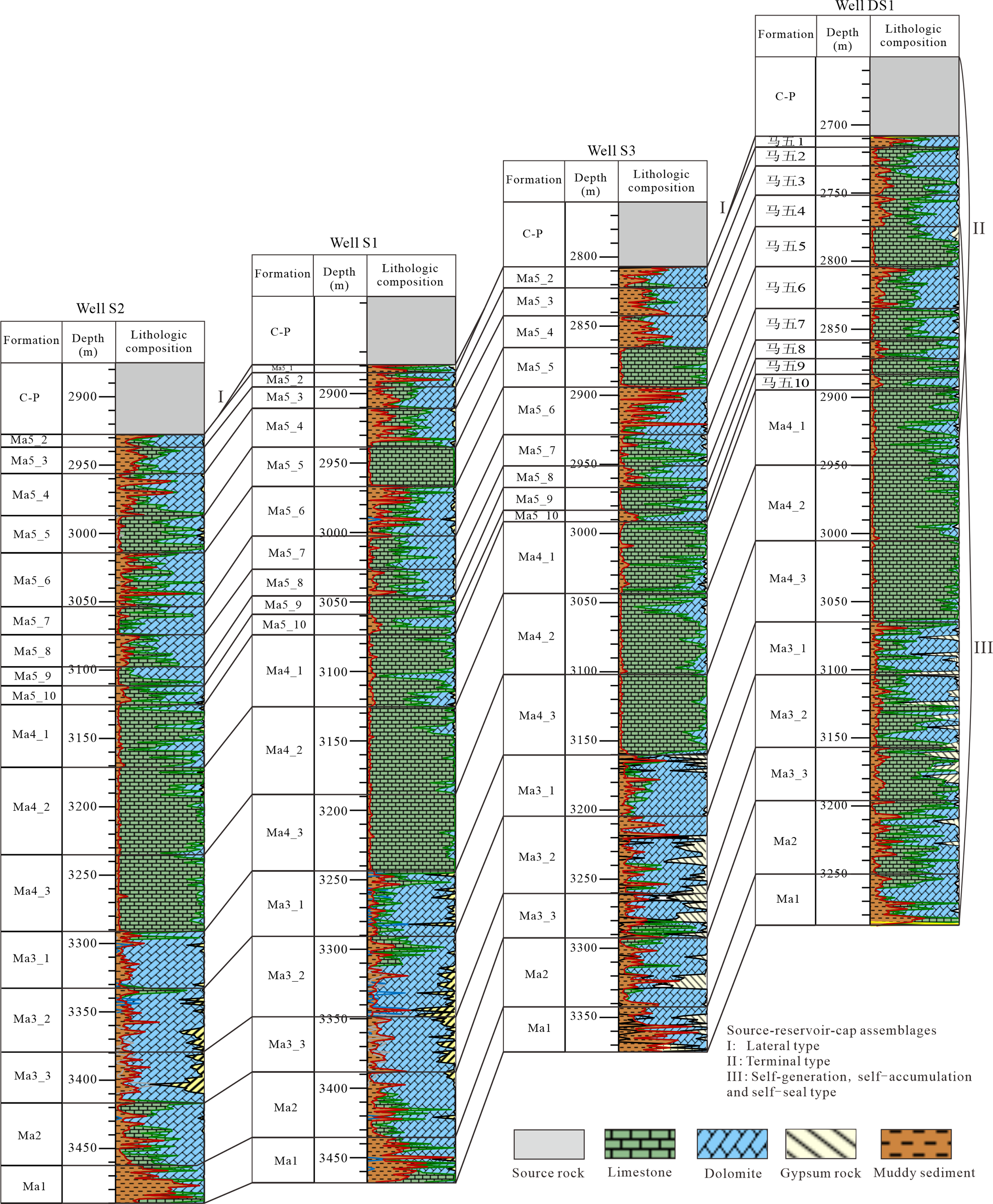
According to the structural characteristics of the Daniudi area in Ordos Basin, an east–west direction section in the study area was selected as a typical section (Figure 2). The location of the section is shown in Figure 1(b) and (c). The length of the section is about 80 km, covering different palaeogeomorphic units such as karst highland and karst slope, and the strike of the section is basically perpendicular to the current tectonic strike. First, the strata and faults of the above section were digitized using the PetroMod 2D software module, and the lithology of the section was constrained by the lithology data of nine individual wells in Figure 2. Then, the geological age, source rock, reservoir and cap elements, denudation thickness, fault activity, fracture distribution, paleo-heat flow, paleo-surface temperature, and paleo-water depth were set. Then, the IP algorithm is used for quantitative simulation of hydrocarbon migration and accumulation. The thermal history and pore evolution history play an important role in controlling the process of hydrocarbon generation, migration, and accumulation, so the measured vitrinite reflectance of source rock and reservoir porosity were used as correction parameters of simulation results. The calculation of vitrinite reflectance in the simulation is based on the EASY%Ro model, while the porosity calculation is based on the compressibility model for different lithologies. Reservoir heterogeneity is mainly reflected by the porosity corresponding to different lithologies. The simulation results were consistent with the actual results at last by repeatedly adjusting the model, and then the simulation results of hydrocarbon migration and accumulation process were analyzed.
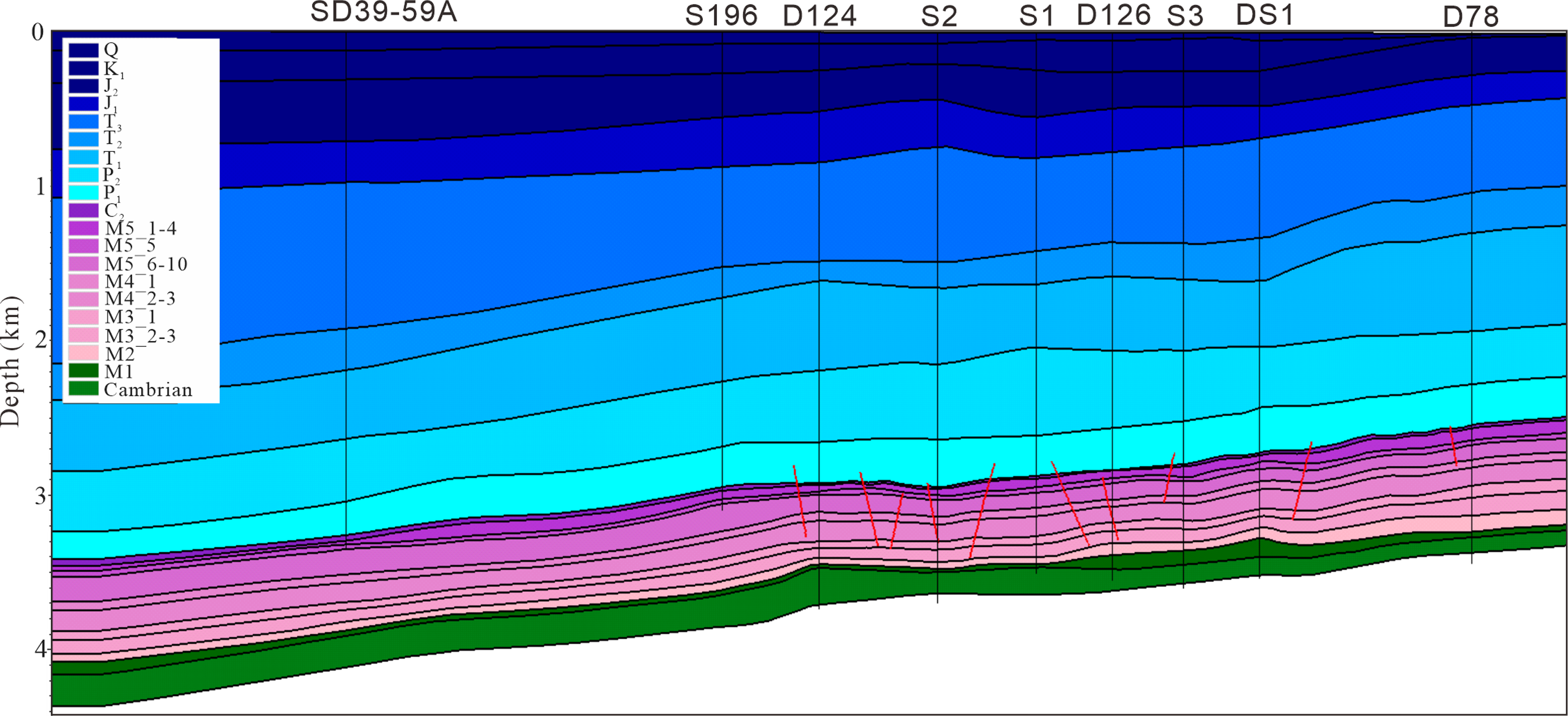
Two-dimensional profile used in the quantitative simulation of hydrocarbon migration and accumulation in the Daniudi area, Ordos Basin.
Results
Source rocks
The source rocks related to hydrocarbons in Majiagou formation in the study area include Upper Paleozoic Carboniferous–Permian and Lower Paleozoic Ordovician Majiagou formation. The geochemical characteristics of source rocks are shown in Table 1. The Carboniferous–Permian source rocks are widely distributed, mainly coal and dark claystone, and the organic matter is medium to good grade abundance, mainly type III, which is in high to over-mature stages.
Statistics of organic matter abundance of Paleozoic source rocks in the Daniudi area
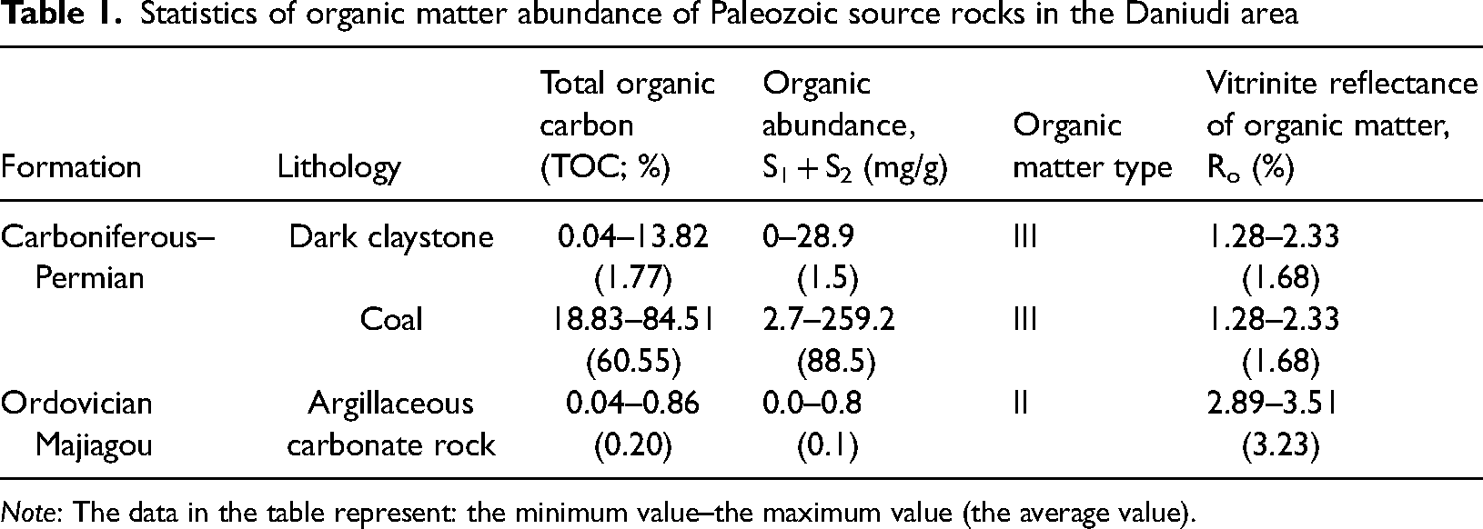
Note: The data in the table represent: the minimum value–the maximum value (the average value).
Tu et al. (2016) showed that the effective source rocks (total organic carbon (TOC) >0.5%) in the Ma3, Ma4, and Ma5 members were the most developed based on the data of Lower Paleozoic Ordovician source rocks in the middle and east of Ordos Basin. Our statistical analysis also shows that the Lower Paleozoic source rocks are mainly distributed in Majiagou formation, mainly in Ma3, Ma4, and Ma5 members. The source rocks are mainly marl and argillaceous limestone, with medium abundance of organic matter and type II as the main organic matter type, which has entered the over-mature stage.
Reservoir rock types and physical characteristics
The rock types of Majiagou formation in Daniudi area are diverse, including karst breccia, mud-microcrystalline dolomite, argillaceous dolomite, calcareous dolomite, and gypsum dolomite. Statistical results (Figure 3) show that Majiagou formation reservoir's physical properties are generally poor, most of porosities are <6%, and the average is 2.0%, belonging to ultra-low porosity to low porosity level. Most of the permeabilities are <0.5 mD, mainly in ultra-low permeability to low permeability levels, but there are fracture reservoirs with permeability more than 1 mD, and the maximum permeability can reach 663 mD. Through the comparison of reservoir physical properties of different members, it is concluded that the physical properties of Ma5 and Ma3 are the best. The pore–permeability relationship of Ma5 member is complex, and multiple reservoir types such as pore type, cavity type, and fracture type are developed, while the fractured reservoir is dominated in Ma3 member. The other reservoirs have relatively poor physical properties and are dominated by pore type reservoirs.
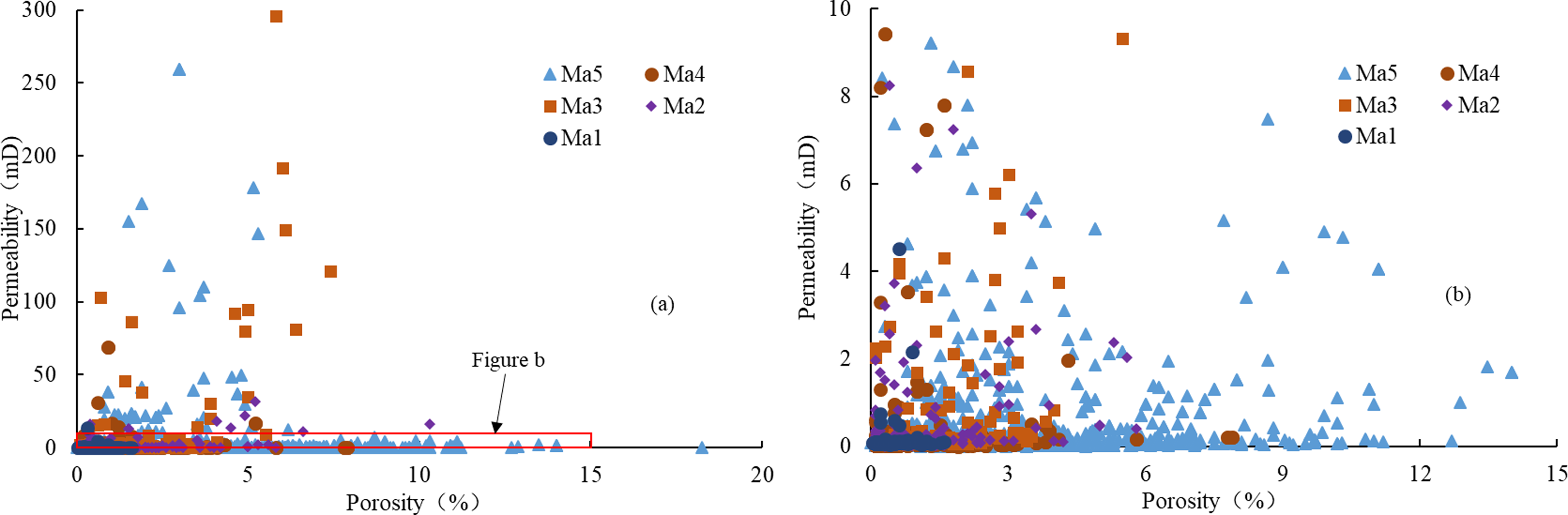
Comparison of porosity and permeability of Majiagou formation in the Daniudi area.
Reservoir space
The reservoir space types of Majiagou formation in Daniudi area include intercrystal pores, dissolution pores, and fractures. Intercrystal pores are mainly distributed in powder and fine crystal dolomite, with pore sizes ranging from 10 to 20 μm and some of them can reach 50 μm (Figure 4(a) and (b)). Dissolution pores are often distributed in groups. The dissolution pores observed in the core are mainly gypsum dissolution pores in Ma3 member, which are distributed along the layer, in the shape of round or pinhole, with different sizes, and most of them are not filled (Figure 4(c) to (e)). Karst caves mainly exist in Ma5 member. The largest diameter of karst caves observed in cores is more than 20 mm, and most of them are completely or partially filled with calcite (Figure 4(f)). Fractures mainly include bedding fractures, karst fractures, and structural fractures. Bedding fractures are mostly distributed at the top and bottom interface of argillaceous carbonate intercalation, partly filled with calcite (Figure 4(g)). Dissolution fractures are widely distributed in Ma5 member, forming a dissolution fracture–cave system together with the caves. Most of them are filled with calcite, but some of them are not filled (Figure 4(h)). Structural fractures include calcite filled high-angle fractures, unfilled network fractures and high-angle fractures, which are widely distributed in Ma4 and Ma5 members (Figure 4(i)).
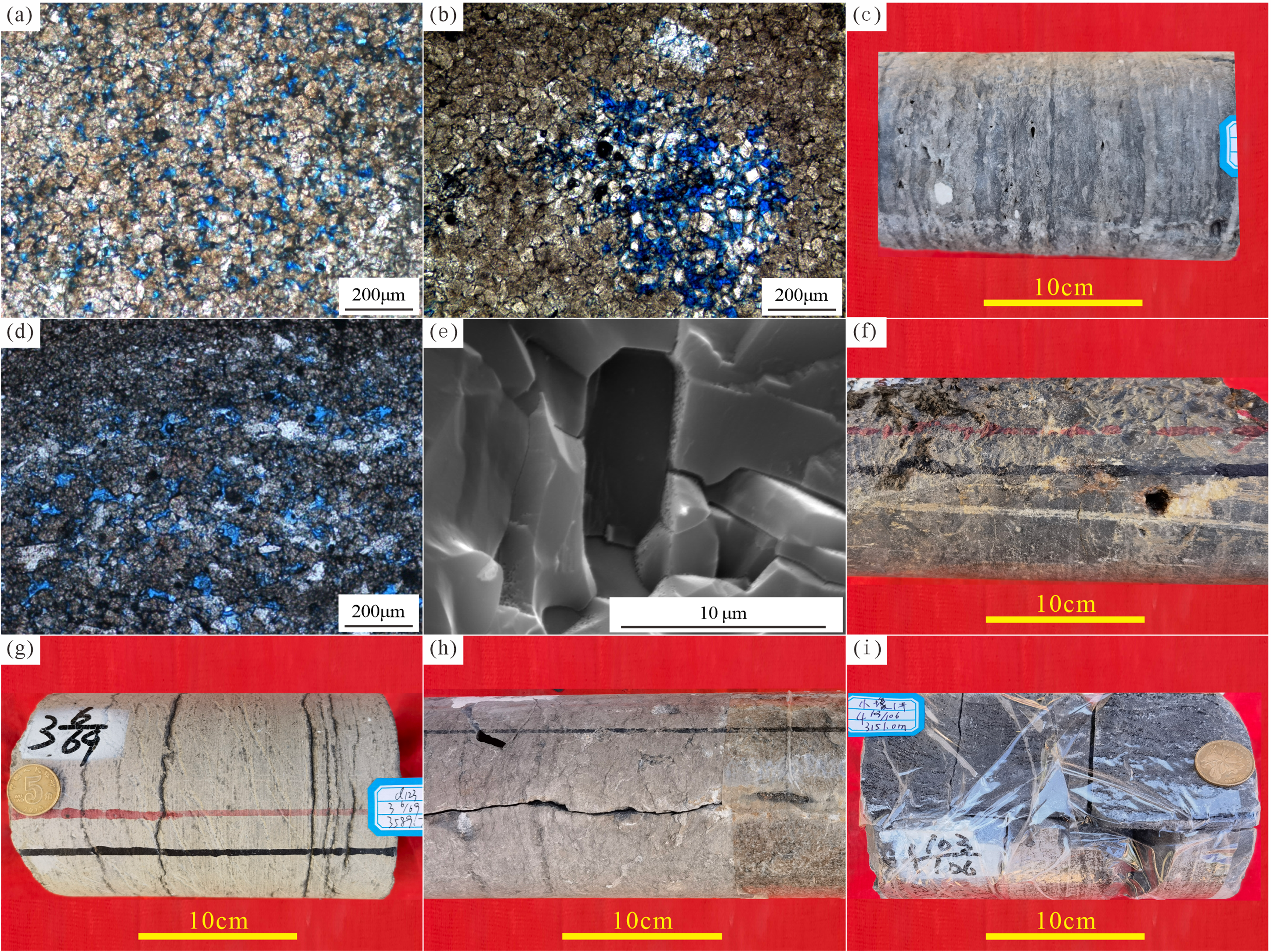
Photographs of reservoir space of Majiagou formation in the Daniudi area. (a) Well D81, Ma5_7 sub-member, powder crystalline dolomite, intercrystalline pores. (b) Well DK13-FP8, Ma5_7 sub-member, powder-fine dolomite, intercrystalline pores. (c) Well XH1, Ma3 member, gypsum dolomite, gypsum karst holes. (d) Well XH1, Ma3 member, gypsum dolomite, gypsum karst holes. (e) Well S2, Ma3 member, gypsum dolomite, gypsum-model dissolution pores. (f) Well D123, Ma5_6 sub-member, limestone, karst cave, partially filled with calcite. (g) Well D123, Ma3 member, limestone, bedding fractures. (h) Well S2, Ma5_7 sub-member, dolomite, high-angle fractures enlarged by dissolution. (i) Well XH1, Ma4 member, limestone, network fractures.
Source rock-reservoir-cap assemblages
The assemblages of Majiagou formation reservoir and Carboniferous–Permian source rock in the study area include upper-generation assemblage and lateral variable assemblage. Hydrocarbon generated from the Carboniferous–Permian coal and dark claystone migrated downward through the fault zone to the karst reservoir and dolomite reservoir of Ma5 member, and bauxite and claystone of Benxi formation were used as cap rocks to form the upper-generation assemblage (Type II in Figure 5). Because the pinch-out zone of Majiagou formation distributes in the west of the study area, and also karst troughs are developed in the study area, so the Carboniferous–Permian source rocks are in direct contact with Majiagou formation reservoir in the lateral direction, resulting in lateral migration of hydrocarbons, forming lateral variable assemblage (Type I in Figure 5).
Types of source rock-reservoir-cap assemblages in Majiagou formation in the Daniudi area.
The hydrocarbon generated from argillaceous carbonatite in Majiagou formation migrated to the reservoirs in Majiagou formation through dolomite reservoirs, fractures, or faults, and the carbonate rocks with poor physical properties are used as cap rocks to form the self-generation-reservoir-cap assemblage (Type III in Figure 5).
The fault to transport hydrocarbon
Faults in the study area were divided into four types, represented by A, B, C, and D in Figure 6. Type A extends from the basement to the Ma3 member but does not break through the Ma3 member, Type B extends from the basement and terminates at the Carboniferous bottom, and it is speculated that both A and B are basement faults activated during the Caledonian period. Type C extends from Majiagou formation through Carboniferous bottom to the Carboniferous system and is presumed to form in the Early Hercynian period. Type D extends from Majiagou formation to the Jurassic system, mainly formed in Indosinian and Yanshanian Periods.
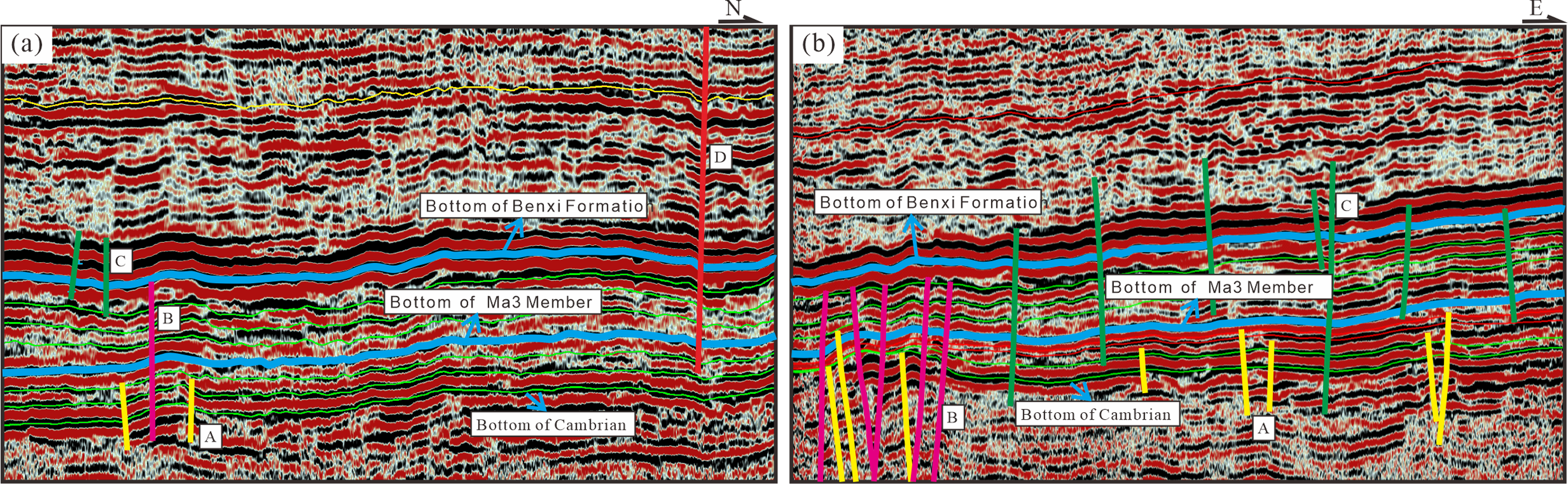
Fault classification of Majiagou formation in the Daniudi area: (a) north–south profile and (b) east–west profile.
Thin section observation shows that there are multi-period fractures in Majiagou formation reservoir in the study area. The early-period fractures are filled with calcite, while the late-period fractures are not filled. The gas–liquid two-phase saline inclusions are developed in the calcite cement of fractures. The homogenization temperatures of the inclusions are between 141 °C and 185°C. Judging from homogenization temperature of inclusions in fracture cements and burial thermal evolution history of reservoir, the early-period fractures are mainly formed in Late Triassic and Early-Middle Jurassic (Figure 7). This is similar to the results of Zhao et al. (2018) on fracture formation time. The late-period fractures have not been filled and are presumed to have formed in the Himalayan period.
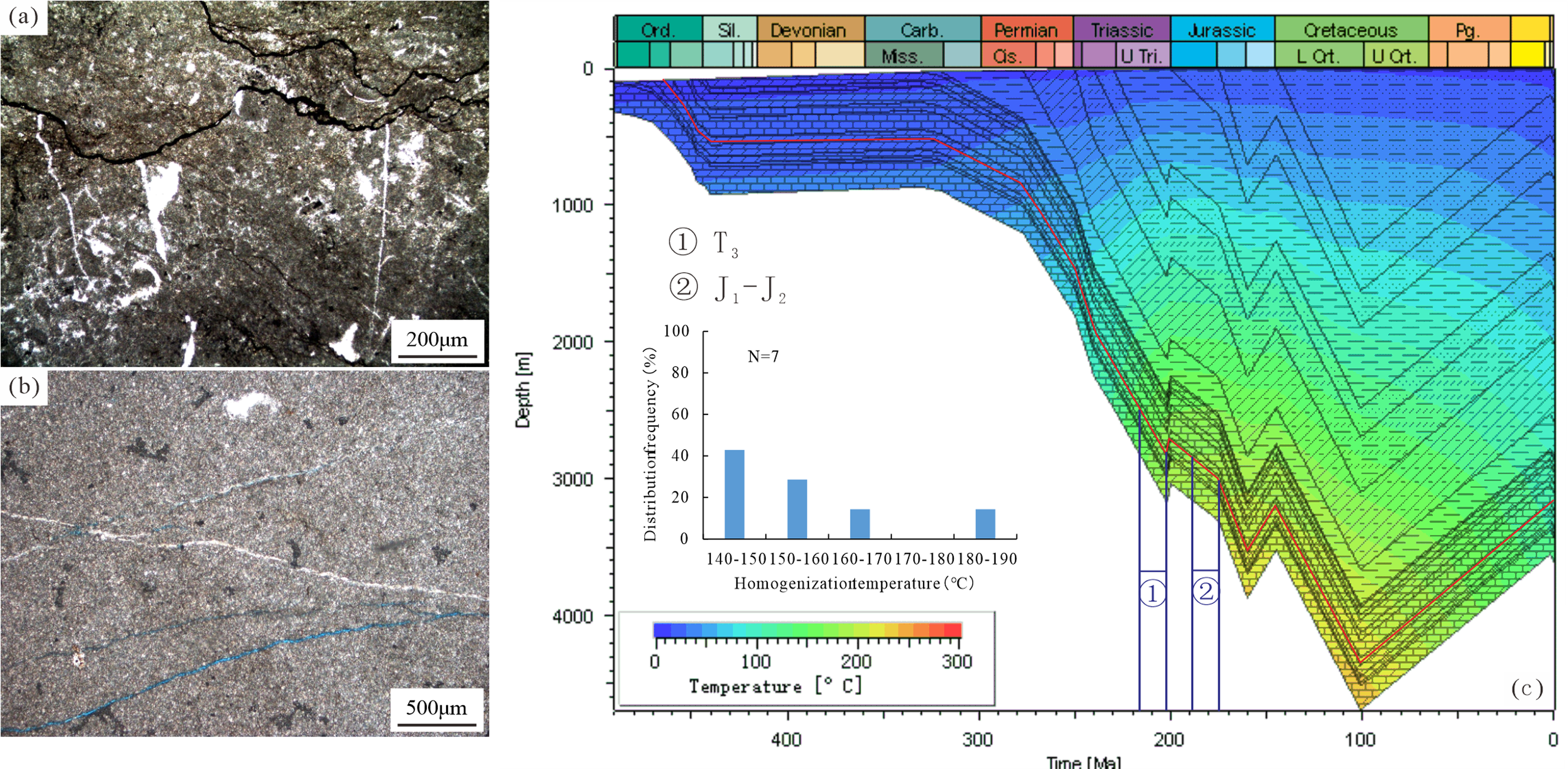
Identification of formation periods of fracture in Majiagou formation in the Daniudi area. (a) Well S1, Ma4 member, calcite filling fractures, their extension terminated at the stylolite. (b) well D53, Ma 5_6 sub-member, at least two periods of fracture, the early one filled with calcite, while the late one unfilled. (c) Well S1, Ma4 member, identification of formation periods of fluid inclusion in the fracture calcite cements.
Numerical simulation results of hydrocarbon migration and accumulation
Model calibration
Through 2D simulation of hydrocarbon migration and accumulation of Majiagou formation in the Daniudi area, the simulation results of vitrinite reflectance (Ro) of Well D124 and porosity of well DS1 were output. Compared with the corresponding actual vitrinite reflectance and porosity (Figure 8), the simulation results are found to be in good agreement with the actual data, which proves that the simulation results are accurate.
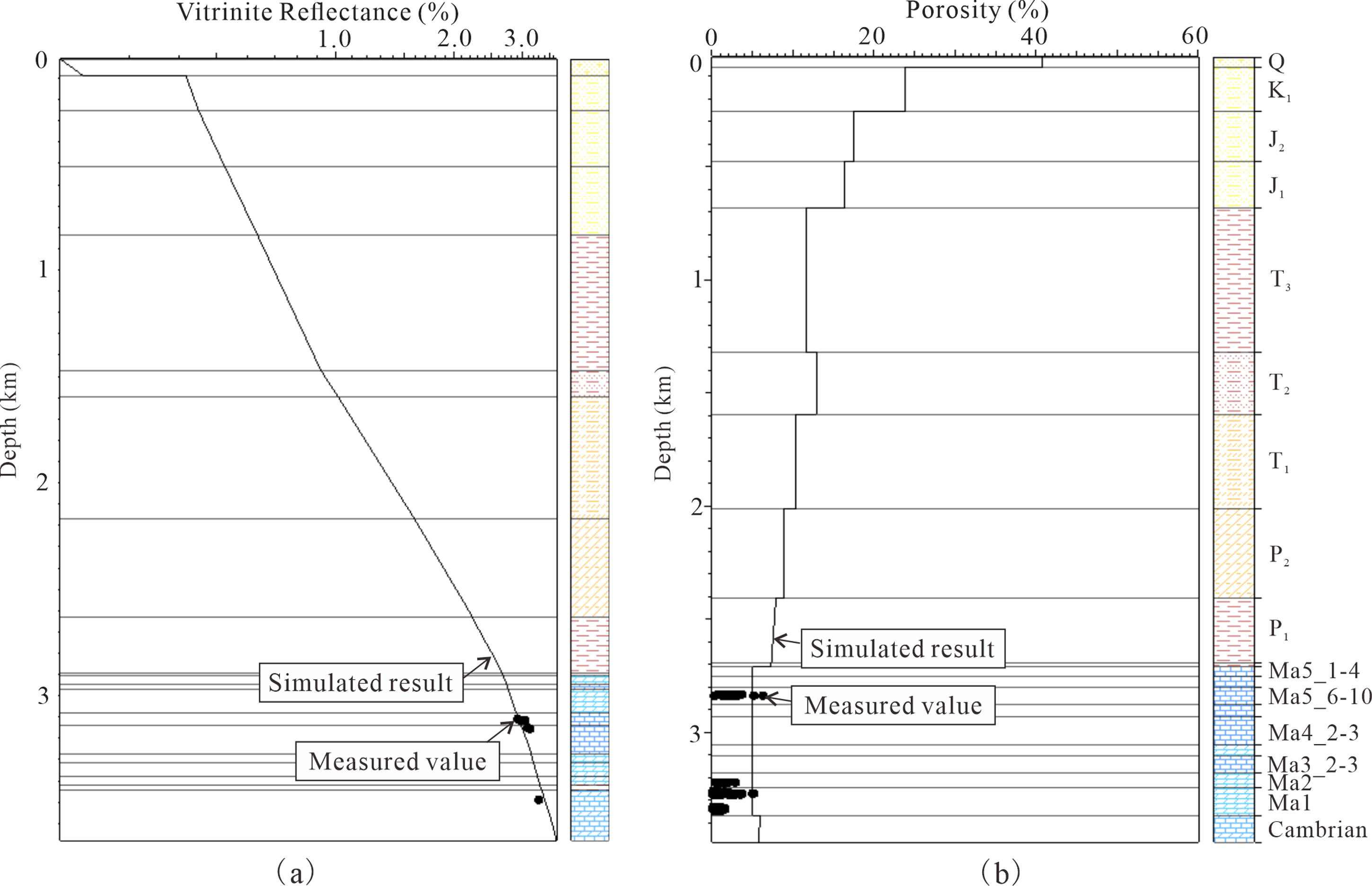
Comparison between simulated results and measured values of vitrinite reflectance of source rock in well D124 (a) and the porosity of reservoir of well DS1 (b).
Hydrocarbon migration and accumulation process
According to the simulation results of hydrocarbon migration and accumulation process, multi-stage hydrocarbon charging and adjustment occurred in Majiagou formation in the study area (Figure 9). At Late Triassic (202 Ma), Majiagou formation began its first hydrocarbon charging, then vertical adjustment or destruction of hydrocarbons occurred due to tectonic uplift at the end of Late Triassic (200 Ma). At the middle Jurassic (160 Ma), due to the increase of burial depth, hydrocarbons were charged into the reservoir again, and hydrocarbon accumulation occurred in the high position, then the hydrocarbons in the area adjusted or destroyed again during the denudation period at the end of middle Jurassic (145 Ma). At the Early Cretaceous (101 Ma), the burial depth of Majiagou formation reached the maximum, and the gas continued to be generated and charged for the third time, which migrated to the structural high parts and fault zones. Then, tectonic uplift occurred in the study area until now (0 Ma), and the natural gas was constantly adjusted or lost, and finally became the present state of natural gas distribution.
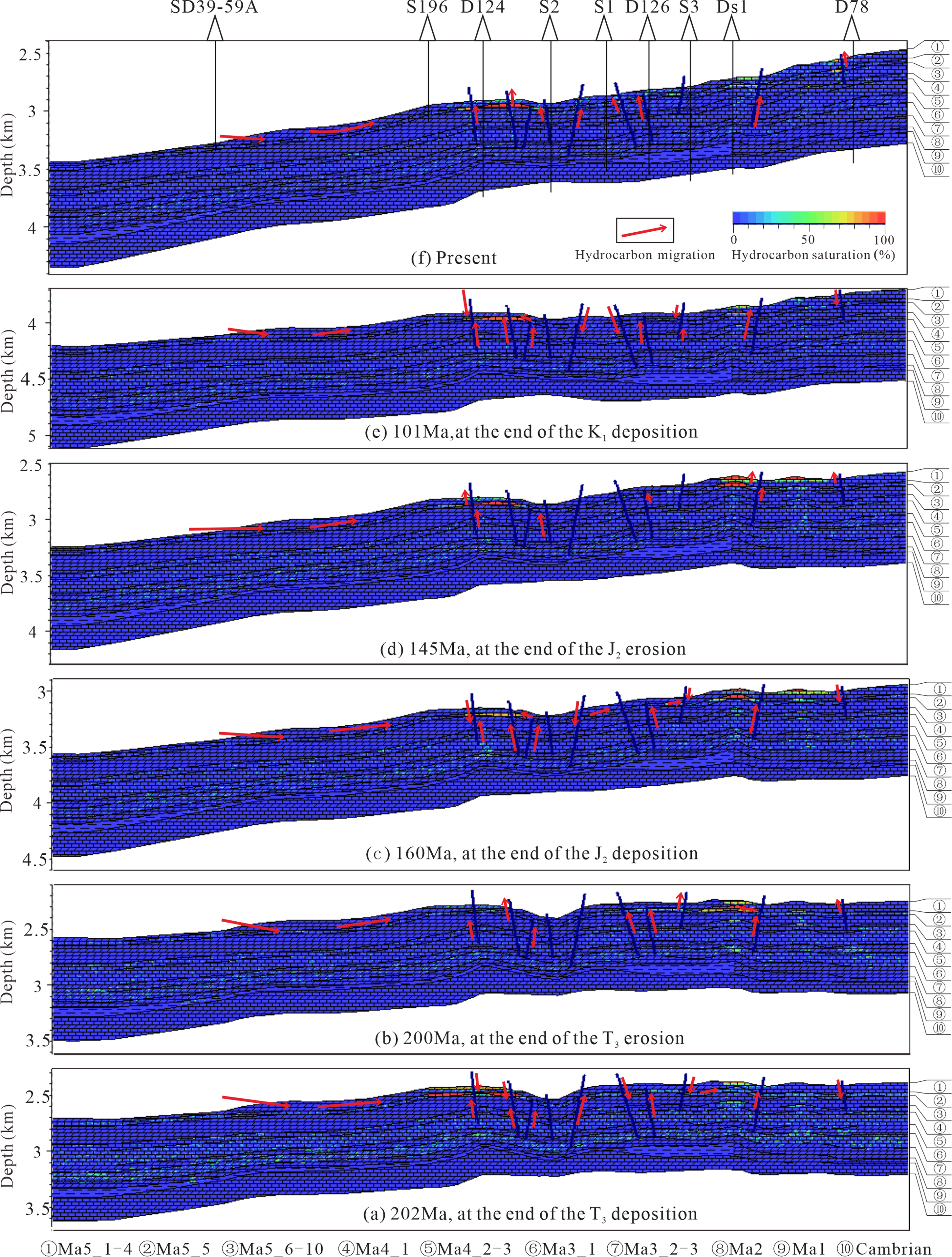
Simulation results of two-dimensional (2D) hydrocarbon migration and accumulation process of Majiagou formation in the Daniudi area.
Discussions
Traditional hydrocarbon migration and accumulation models mainly use the “simple stratification model,” which uses the current large-layer sedimentary facies map for lithology assignment, and only considers the simple lithofacies heterogeneity (Liu and Liu, 2017), which can only simulate the macroscopic hydrocarbon migration and accumulation rules, and it is difficult to characterize the differences in hydrocarbon migration and accumulation. In this model, the lithologic compositions of wells were used to assign lithologic values in small layers to achieve the heterogeneity of the reservoir in the horizontal and vertical directions, with greater accuracy, and the current porosity is used to constrain the results as close as possible to the reality. The method used to simulate hydrocarbon migration and accumulation is the IP method suitable for a heterogeneous geological model, which improves the accuracy of migration and accumulation process compared with traditional Darcy flow and Flowpath methods. From the simulation results (Figure 9), the space for oil–gas migration and accumulation also shows the characteristics of non-uniform, reflects the characteristics of a multiple small layers model. And the hydrocarbon migration, accumulation, and escaping process in different geologic periods is consistent with the actual tectonic evolution. Therefore, the simulation result of the model is closer to the actual geological exploration of oil and gas, which can better predict favorable hydrocarbon accumulation locations.
Type of transportation system
The variation of oil and gas saturation in Figure 9 is the result of oil and gas migration and accumulation along different migration pathways. The study area has four basic migration pathway types: (a) lateral contact in the pinch-out area, (b) source rock-reservoir contact in the trough area, (c) fault-connected, and (d) source rock-reservoir superposition. Because of the Carboniferous–Permian and Ordovician source rocks, there are transport pathways for natural gas from the Carboniferous–Permian and transport pathways for natural gas from the Ordovician Majiagou formation. The formation and evolution of different migration pathways play different roles in the migration and accumulation of natural gas. In contrast, lateral contact in the pinch-out area and fault-connected migration pathways are the most developed in the study area, which connected the largest source rock area, and are believed to play a major role in oil and gas transport.
Transport pathways for natural gas from the Carboniferous–Permian
At the end of middle Ordovician, Ordos Basin experienced a hiatus lasting about 130 to 150 Ma due to the overall uplift because of the Late Caledonian movement (He et al., 2013; Wang et al., 2014). During this period, the Ordos Basin was characterized by karst highland, karst slope, and karst basin from west to east, showing the palaeogeomorphic characteristics of high in the west and low in the east, resulting in the gradual decrease of the denuded strata of Ordovician Majiagou formation from west to east (Wang et al., 2014). The study area is mainly located in the karst highland and karst slope in the north of the basin (Ding et al., 2016). The formation of Ma5 member in the west of the study area is subjected to different degrees of denudation, while part of the Ma5_1 to Ma5_4 sub-members was denudated in the study area, resulting in the lateral contact window between the Carboniferous–Permian source rock and Ma5 member in the pinch-out area of the study area and its west Since the Triassic, the Ordos Basin has experienced a seesaw-like tectonic pattern change from “high in the west and low in the east” to “low in the west and high in the east,” resulting in the lateral contact window between the Carboniferan–Permian and Ma5 member in the west of the study area becoming favorable pathways for gas migration and accumulation (Figure 10(a)). The natural gas generated from the Carboniferous and Permian source rocks can migrate directly into the reservoirs of Ma5 member and also migrate to the east to some extent.
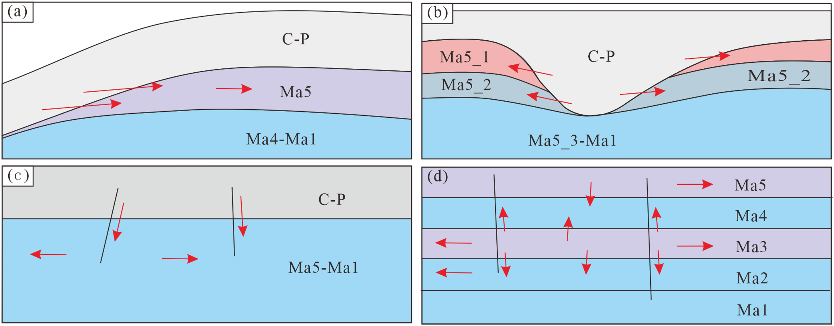
Classification of natural gas transport pathways of Majiagou formation in the Daniudi area: (a) lateral contact in the pinch-out area, (b) source rock-reservoir contact in trough area, (c) fault-connected, and (d) source rock-reservoir superposition.
Due to differential karstic processes at the top of the Ordovician Majiagou formation, uneven characteristics were developed and strong karst occurred in low-lying areas. The Ma5_1 and Ma5_2 sub-members were denuded and directly filled by the Carboniferous–Permian strata, thus forming a trough-type transport pathway (Figure 10(b)). The natural gas generated from Carboniferous and Permian source rocks in the trough directly migrated laterally into the Ma5_1 and Ma5_2 sub-member reservoirs.
The study area experienced multi-stage tectonic movements such as Indosinian, Yanshanian, and Himalayan (He et al, 2021), forming different periods of faults and fractures, and the faults formed in the early stage would be activated in the later stage of tectonic movement, thus having a certain transport capacity. The Carboniferous–Permian system in the study area formed strong abnormal high pressure during the hydrocarbon generation period, which could drive natural gas to migrate vertically downward along the fault (Figure 10(c)) and accumulate in favorable reservoirs of Majiagou formation.
The tectonic uplifts in the Indosinian, Yanshanian, and Himalayan periods, accompanied by denudation and fracture formation, are the reasons for the loss of natural gas in the Ordovician Majiagou formation. As can be seen from the 2D profile simulation results, the accumulation scale of natural gas in the reservoir during the tectonic uplift period becomes smaller, indicating the escape and adjustment of natural gas. Sun et al. (2009) also showed evidence that natural gas was released to the surface in the northern Ordos Basin.
Transport pathways for natural gas from the Ordovician Majiagou formation
In the study area, both source rocks and reservoirs are developed in the Ordovician Majiagou formation, which are superimposed vertically. Hydrocarbons generated from source rocks can directly migrate vertically to the dolomite reservoir or migrate from source rock to the reservoir through faults (Figure 10(d)), and then the natural gas migrates laterally along the dolomite reservoir. According to the tectonic evolution of the study area, Majiagou formation source rocks in the southwest and south of the study area are relatively developed (Tu et al., 2016), which may be the main source area for Majiagou formation to generate natural gas.
Main controlling factors of hydrocarbon migration and accumulation
According to the hydrocarbon accumulation process and the difference in final hydrocarbon saturation of Majiagou formation in the Daniudi area, it is believed that the main controlling factors of hydrocarbon migration and accumulation in the study area are structural morphology, fault zone, and reservoir quality.
Majiagou formation in the study area is low in the west and high in the east, and there are local structural high positions under the macro structural background. These structural high positions are the strongest structural deformation area, which is conducive to the formation of fractures. These high positions are also relatively low distribution areas of fluid mechanical energy, which is conducive to the accumulation of hydrocarbons. This was confirmed by the hydrocarbon saturation distribution of simulation.
The fault zones of different grades were formed in the positions of strong tectonic activity in the study area, which not only connect Majiagou formation reservoir with Upper and Lower Paleozoic source rocks, but also become important pathways for hydrocarbons transport. In addition, there are often many fractures in or near the fault zone, which become favorable hydrocarbon accumulation places. The simulation results also show that the hydrocarbon saturation near the fault zone is relatively high.
Majiagou formation in the study area has poor physical properties, but there are weathering crust reservoirs of Ma5 member at the top of Majiagou formation and fractured reservoirs of Ma3 member, which become high-quality reservoirs with relatively good physical properties. The simulation results show that the high hydrocarbon saturation locations are distributed in these reservoirs, and the better the physical properties, the higher the hydrocarbon saturation.
Conclusions
This simulation model constrains the heterogeneity of reservoir through the change of single well lithology, and vitrinite reflectance of source rocks and reservoir porosity are used as correction parameters, and the hydrocarbon migration process is simulated by the IP algorithm, which achieves good results.
Three types of source rock-reservoir-cap assemblages are developed in Majiagou formation of the study area: upper-generation lower-reservoir-cap assemblage, source-reservoir-cap combinations with lateral changes, and self-generation and self-reservoir-cap assemblage.
Simulation results show that the Majiagou formation in the study area began to be charged with hydrocarbons at the end of the Late Triassic and has undergone three periods of hydrocarbon charging and three periods of hydrocarbon adjustment. The hydrocarbon migration pathways include lateral contact in the pinch-out area, source-reservoir contact in the trough area, fault-connected and source-reservoir composite, and overlay.
Structural morphology and fault zones are the strongest parts of structural deformation, and the fractures are relatively developed, which control the location of hydrocarbons accumulation, while the reservoir quality directly controls the degree of hydrocarbons saturation.
Footnotes
Declaration of conflicting interests
The authors declared no potential conflicts of interest with respect to the research, authorship, and/or publication of this article.
Funding
The authors received no financial support for the research, authorship, and/or publication of this article.