
Abstract
As an important exploration target in the Sichuan Basin, the Lower Triassic Feixianguan Formation has been previously interpreted to be deposited in the trough-platform margin system according to the genetic model of classic lithofacies paleogeography. However, this model does not apply to the northwestern Sichuan Basin. Accordingly, this study proposed a new genetic model that highlighted the carbonate ramp based on the outcrop sections, drilling and logging data, and seismic sections. A large-scale regional regression was found to occur in Sichuan Basin at the end of the Late Permian, leading to the evolution of the original Kaijiang-Liangping Trough into a very shallow tidal flat/lagoon environment at the beginning of the Early Triassic. The sedimentary pattern during the Early Triassic was different from that during the Late Permian. A total of six long-term cycles (LSC1-LSC6) were identified within the Feixianguan Formation. The deposition of LSC1-LSC3 witnessed the filling of the trough to a large extent, and the depositional periods of LSC4 and LSC5 were the main shoal-forming periods. The Feixianguan Formation in the study area was speculated to be deposited in the continuous continental carbonate ramp. With the intensified uplifting of the Longmenshan island chain and the Kangdian ancient land on the northwestern margin of the Upper Yangtze Platform, a large number of terrigenous materials were input into the study area from west to east, leading to the continuous eastward migration of the carbonate facies belt during the deposition of the Fei 1 and Fei 2 Members. Meanwhile, large-area inner-ramp shoal bodies were formed during the deposition of LSC5. It became possible to find a giant gas reservoir belt in the Feixianguan Formation of the northwestern Sichuan Basin and the results of this study provide a new complement to the existing classic trough-platform margin shoal-forming model.
Keywords
Introduction
As an important petroliferous basin in China, the Sichuan Basin is abundant in natural gas resources, with 85% of them hosted in the marine carbonate strata (Guo, 2011; Ma et al., 2019; Shi et al., 2018; 2020; Xiao et al., 2020; 2021). Specifically, the natural gas resources in the Lower Triassic Feixianguan Formation account for nearly 12% of the total in the marine carbonate strata. Therefore, the Feixianguan Formation has long been an important exploration target, especially in the northeastern part of the basin. A series of large-scale gas reservoirs have been found in the oolitic shoal deposits of the Feixianguan Formation, including Dukouhe, Luojiazhai, Tieshanpo, Puguang, Huanglongchang and Longgang gas fields (Guo, 2011; Liu et al., 2009, 2016; Ma et al., 2005; Zhu and Zhong, 2013).
With recent exploration progress in the deep-buried marine carbonate strata, oil and gas shows have been seen in the northwestern Sichuan Basin, including Shuangyushi, Jiange, and Jiulongshan Areas, which reveals good exploration potential and prospects (Dong, 2019; Hu et al., 2019). It is generally believed in the previous research that the Kaijiang-Liangping Trough was formed during the Changhsingian Period in the northern Sichuan Basin, and the trough-platform differentiation during the late Changhsingian Period was inherited during the early Feixianguan Period (Wang et al., 2002, 2002; Wei et al., 2004). In this geological context, there were still complete facies assemblages that consist of platform, platform margin, slope, and basin facies. The Kaijiang-Liangping Trough was thought to be filled due to the continuous seaward migration of the platform and platform margin facies (Ma et al., 2005; Wei et al., 2004). However, whether this depositional model applies to the entire periphery of the Kaijiang-Liangping Trough remains unknown.
The exploration intensity of the Feixianguan Formation in the northwestern Sichuan Basin is much lower than that in the northeastern Sichuan Basin. It was found in a recent survey that the oolitic shoal deposits in northwestern Sichuan had a relatively thin cumulative thickness, and they were not encountered during the drilling of Well JT1 at the positive synsedimentary-geomorphological position near the platform margin slope break, which was not expected. Therefore, the occurrence and development pattern of the oolitic shoal deposits in northwestern Sichuan may be different from those in northeastern Sichuan. Thus, it is critical to investigate the coupling relationship between the depositional environment during the early Feixianguan Period and that during the late Changhsingian Period as well as reconstruct the sequence filling process and classify the depositional systems during the Feixianguan Period. In this study, various types of data, including 2 D and 3 D seismic volumes, logging data, core data, and outcrop sections, were employed to reveal the sequence filling process during the Feixianguan Period based on the theory of high-resolution sequence stratigraphy and the implementation of well-seismic joint analysis. Furthermore, the lithofacies paleogeography was re-analyzed, results of which were expected to help gain a better understanding of the depositional system during the Early Triassic and guide future exploration in the shoal and reef deposits of the Sichuan Basin.
Geological background
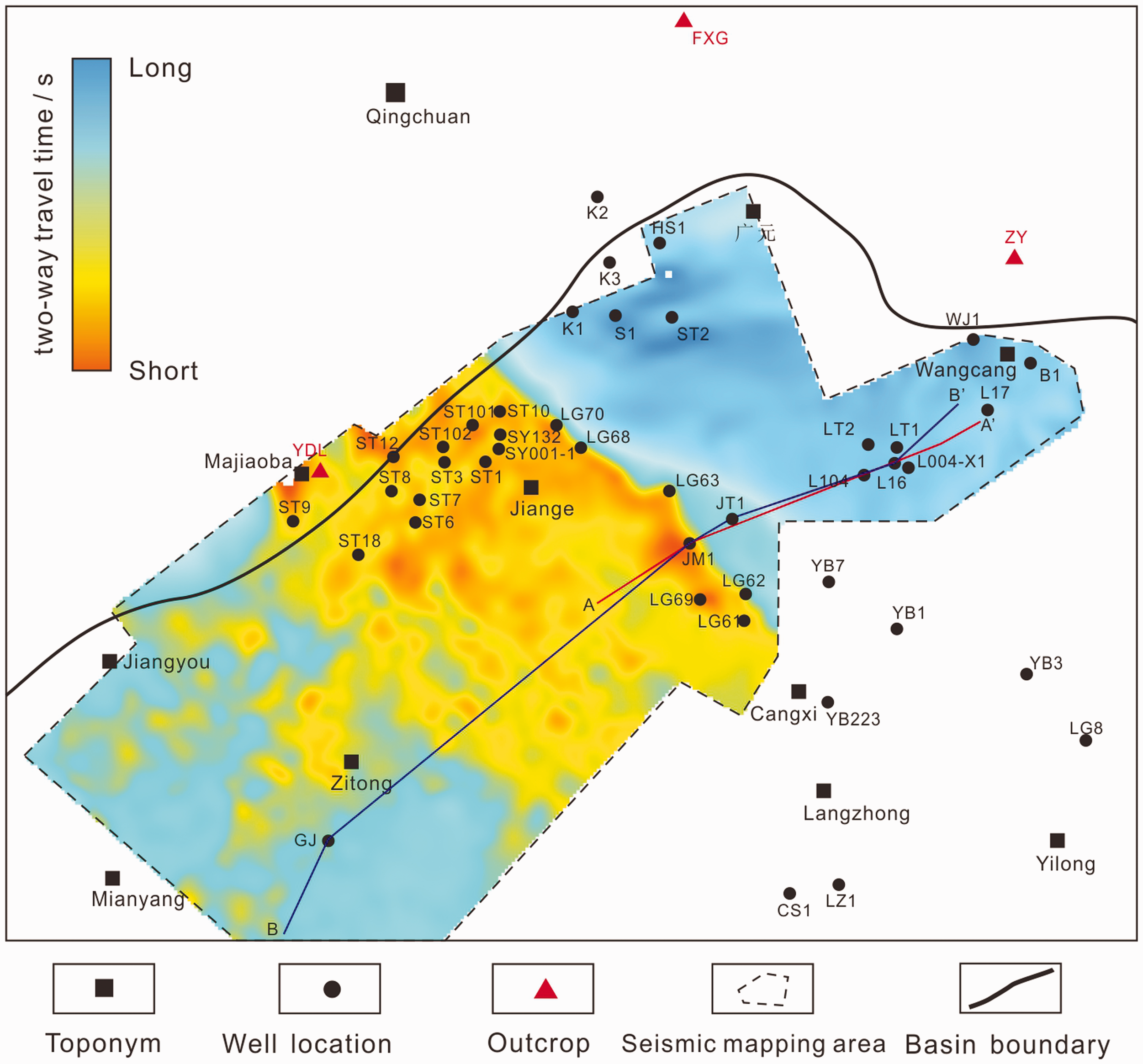
The study area is in the northwest of the Sichuan Basin, and it is located on the northern margin of the Upper Yangtze Craton. It is tectonically in the transition zone between the Longmenshan fault fold belt, the Micangshan uplift, and the low-gentle tectonic belt of the northern Sichuan central paleo-uplift, while it geographically spans Mianyang City, Guangyuan City, Jiange City, and Cangxi County, covering an area of ∼30500 km2. Multiple episodes of tectonic movements resulted in the expansion of the Mianlue Ocean and the Emei taphrogeny, which greatly impacted the depositional pattern during the Middle-Late Permian (Xu et al., 2014). Meanwhile, a rifting complex emerged on the northern margin of the Yangtze Plate (Yao et al., 2011), and the Kaijiang-Liangping Trough was gradually formed under the action of tensile stress in the northern Sichuan (Luo, 1989, 2012; Luo et al., 1988; Wu et al., 2019; Yao et al., 2011), whose dimension reached the maximum during the Changhsingian Period, forming an obvious trough-platform system (Figure 1) and two sets of contemporaneous heterotopic facies deposits (i.e., relatively shallow water Changxing and deepwater Dalong Formations). Subsequently, the Mianlue Ocean began to close during the Feixianguan Period and the trough gradually disappeared, eventually forming a relatively uniform platform environment (Luo, 2012; Wang and Zhao, 2002; Wen et al., 2012; Zhang et al., 2013, 2019). Therefore, the Feixianguan Formation in the northwestern Sichuan Basin witnessed the transition from trough-platform differentiation to platform homogenization. The thickness of the Feixianguan Formation varies from 330 to 920 m, which is complementary to that of the underlying Changxing/Dalong Formation. The Feixianguan Formation was generally deposited in the transition zone from the mixed clastic-carbonate depositional environment to the pure carbonate depositional environment, accompanied by complex lithological features. The Feixianguan Formation can be divided into 4 members based on lithology, with main compositions of gray micrite, marl, gray-white oolitic limestone, purple-red calcareous mudstone, and mudstone. Argillaceous dolomite and gypsum deposits are seen at the top of the Feixianguan Formation (Figure 1).
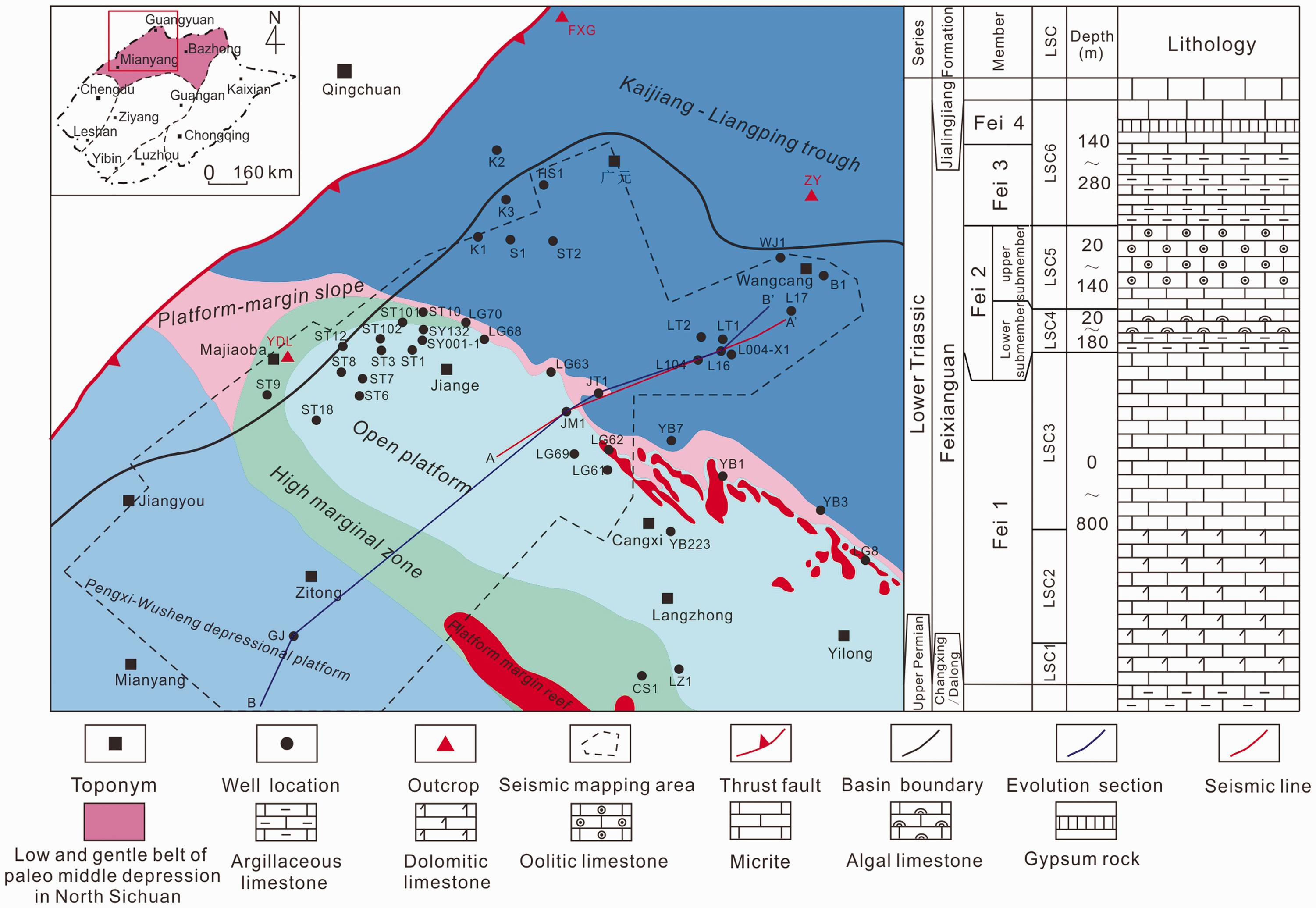
Location and depositional environment of the study area and the stratigraphic column of the Lower Triassic.
Sequence framework of the Feixianguan Formation
Sedimentary pattern before the Feixianguan period
It has been gradually confirmed worldwide that sea level generally declined at the end of the Permian (Deng et al., 2015; Li et al., 2016; Yin et al., 2014). In the previous research, sea level is argued to drop at the end of the Changhsingian Period, and it only results in a brief exposure on the top of some local highlands (such as reefs and shoals). From a regional perspective, inherited continuous deposition was indicated to occur during the Feixianguan Period in the previous research, and thus there should be conformity between the Feixianguan Formation and the underlying Changxing Formation. However, in this study, both direct and indirect evidence was found in northwestern Sichuan Basin that reflected the dramatic drop in sea level at the end of the Changhsingian Period.
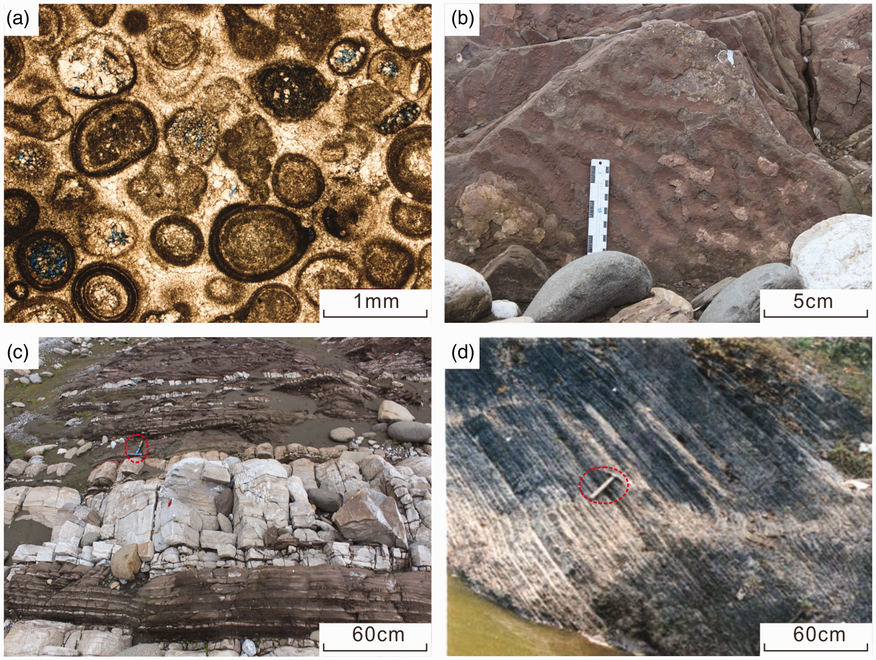
The presence of unconformity or weathered residual layer is the most direct evidence of exposure and sea-level drop. Specifically, the unconformity is seen in the Yudongliang Section on the west side of the study area (Figure 1), which was at the platform margin at the end of the Changhsingian Period. Moreover, both the top of the Changxing Formation and the bottom of the Feixianguan Formation are well exposed and the Permian-Triassic boundary is clear (Figure 2(a)). Triassic microbialite is dominant above the unconformity, while thin-layered sparry bioclastic limestone and coral skeleton rock lens of Changxing Formation take the dominance below the unconformity (Figure 2(b)). The top surface of the unconformity is undulating, with erosion and funnel-like filling structures developed. The main filling materials are earthy-yellow breccia and brown-black carbonic-argillaceous components (e.g., clay and organic matter) (Figure 2(c)). A large amount of carbon and muddy complexes are observed to fill between the breccias under the microscope, and there is a certain transition between the filling and the bedrock in some local areas, which indicates that the breccias are formed by dissolution and detachment of the bedrock (Figure 2(d)). Moreover, the Late Permian Palaeofusulina fossil belt is absent, whereas Codonofusiella commonly seen in the Wujiaping Formation was observed in the bioclastic limestone on the top of the Changxing Formation (Figure 2(e)), indicating the presence of a long-term exposure unconformity at the top of the Changxing Formation in the Yudongliang Area.
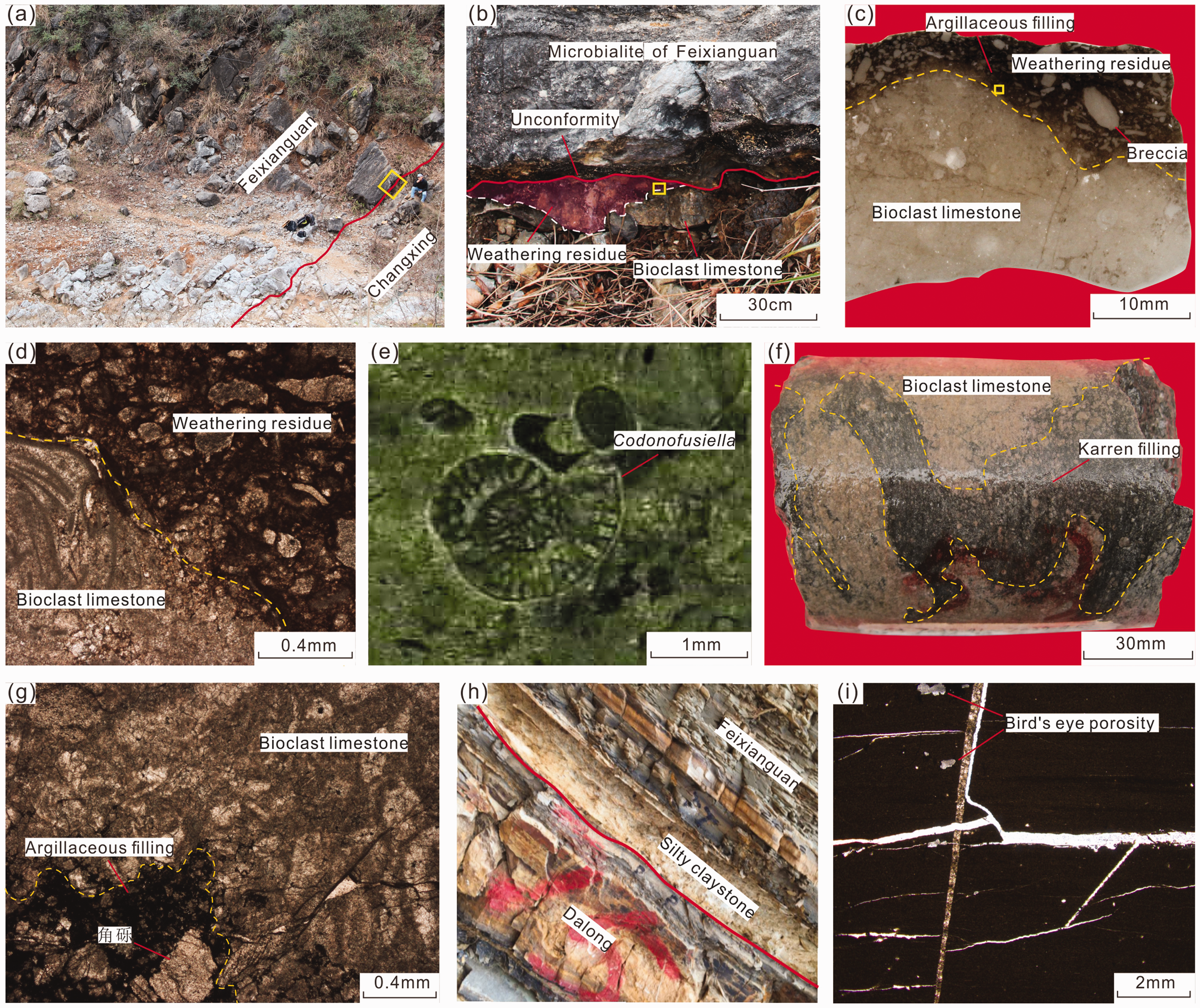
Evidence of exposure and water shallowing at the end of the Changhsingian period in the study area. (a) Yudongliang Section showing the macroscopic characteristics of the Permian-Triassic boundary; (b) A zoomed-in view of the Yudongliang Section (see its location indicated by the yellow rectangular in (a)), where the unconformity between the Changxing and Feixianguan Formations is obvious and filled with weathering remains; (c) A zoomed-in view of the yellow rectangular in (b), showing the clear boundary between bedrock and weathered residual filling; (d) A microscopic view of the yellow rectangular in (c), where the bedrock is mainly bioclastic limestone while the weathered residual filling is composed of carbonic-argillaceous components, biological debris, and broken breccia; (e) Codonofusiella observed in the bioclastic limestone at the top of Changxing Formation under the microscope; (f) Core in Well LG63, the top of the Changxing Formation, developed karst karrens, 7039.41 m; (g) Thin section of core in Well LG63, where the bedrock (i.e. bioclastic limestone) has a sharp contact with the karren fillings (i.e. carbonic-argillaceous components, biological debris, and broken breccia); (h) Feixianguan Section in the Shangsi Area showing the macroscopic characteristics of the Permian-Triassic boundary, above which is the rhythmic interbeds of very shallow tidal flat/lagoon limestone and claystone; (i) Thin section of the rocks from the Zhengyuan Section showing the microscopic characteristics of the Permian-Triassic boundary, above which is the extremely shallow water tidal flat environment with bird's eye structure seen in the micrite dolomite.
Well LG63 was also located at the platform margin at the end of the Changhsingian Period (Figure 1). The palaeokarst characteristics can be clearly observed in the core of the top of the Changxing Formation (Figure 2(f)). Moreover, light-gray bioclastic limestone was observed to be cut by crisscross karst karrens whose boundaries are curved and smooth. These karrens show certain transition relationships with the bedrock locally (Figure 2(f)). Clear boundaries between the bedrock and the karren fillings were seen under the microscope, and the karren fillings are mainly composed of biological debris, crystal grains, clay, and carbonic matter (Figure 2(g)).
As a Global Boundary Stratotype Section and Point (GSSP) for the PT boundary, the Feixianguan Section in the Shangsi Area was located inside the trough at the end of the Changhsingian Period (Figure 1). In the previous research, claystones above and below the boundary were believed to have completely different sedimentary backgrounds. Specifically, thin-layered limestone and claystone are interbedded in rhythm above the PT boundary. The claystone is yellow-green and brown in color and contains silty and illite components (Figure 2(h)), with horizontal bedding, occasionally seen thin volcanic ash and gypsum layer, and mixed terrigenous clastics (e.g. quartz and feldspar). Therefore, it could be inferred that the claystone should be transported by surface runoff and formed in the shallow tidal flat or lagoon environment in an arid climate. In contrast, the claystone below the boundary was formed in the Dalong Formation, with dominant gray-black color. It is mainly composed of irregular illite/smectite mixed layer, with rare terrigenous clastics. Therefore, this claystone should be the product of normal chemical precipitation in the deep-water environment. The Zhengyuan Section in the Wangcang Area was also located inside the trough at the end of the Changhsingian Period (Figure 1), and it has the same petrological characteristics at the PT boundary as the Feixianguan Section in the Shangsi Area. Moreover, the bird’s eye structure was seen in the micrite dolomite above the boundary, which was a typical indicator of the shallow-water tidal flat environment (Figure 2(i)).
Meanwhile, extremely shallow water characteristics were observed in the Lower Feixianguan Formation in Well L16 (Figure 3), which was drilled in the trough area. In terms of the features in the logging curves, the Dalong Formation is characterized by relatively high GR and AC values, while the bottom of the Feixianguan Formation is characterized by relatively low GR and AC values and flat curves. It was found in the thin sections that the bottom of the Feixianguan Formation is mainly comprised of dolomitic micrite limestone and micrite dolomite, indicating the restricted depositional environment with extremely shallow water bodies. These shallow-water features remain until the core depth reaches 5752 m, and this interval primarily consists of dolomitic micrite limestone, micrite dolomite, calcareous mudstone, and silty mudstone.
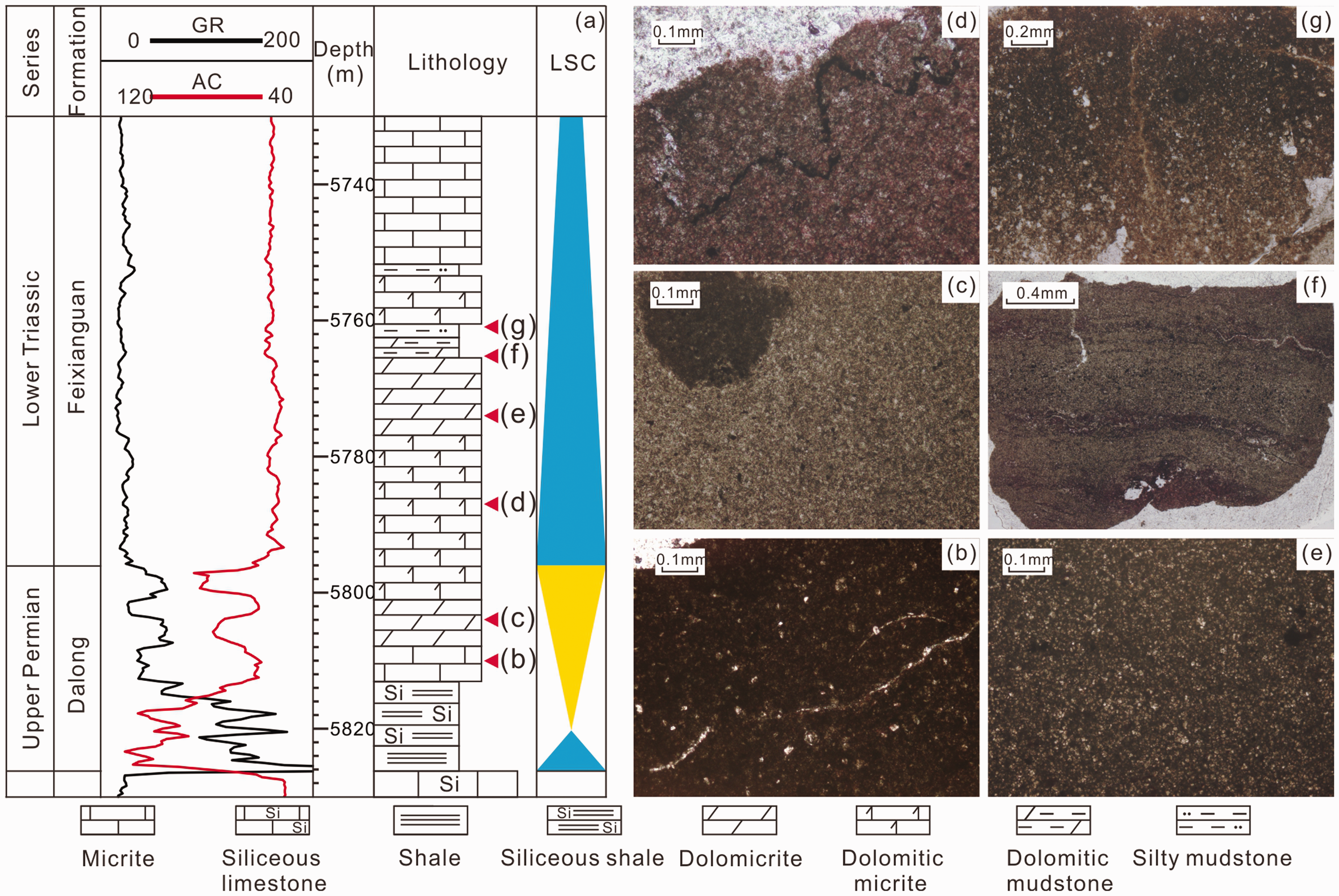
The upward-shallowing cycle at the end of the Changhsingian period and the extremely shallow-water characteristics at the beginning of the Feixianguan Period as recorded in Well L16. (a) Stratigraphic column including the Changxing-Feixianguan Formations in Well L16 and comparison between the old and new schemes on the bottom boundary of the Feixianguan Formation; (b) Dolomitic micrite limestone with a small number of organisms, 5810 m; (c) Micrite dolomite, 5804 m; (d) Dolomite micrite dolomite, with bioclastics, 5787 m; (e) Micrite dolomite, 5774 m; (f) Banded calcareous mudstone, 5766 m; (g) Silty mudstone, 5761 m.
Based on the above analysis, it is concluded that there was a significant sea level decline in northwestern Sichuan at the end of the Late Permian Changhsingian Period, resulting in exposure and subsequent weathering of platform, platform margin, and slope during the Changhsingian Period. The water level was relatively low in the Early Triassic, and a restricted environment (e.g. restricted tidal flat/lagoon) was formed in the original Kaijiang-Liangping Trough area (Figure 4). The deposition of the Feixianguan Formation was initiated in this environment, which determined the fact that the depositional pattern of the Lower Feixianguan Formation was completely different from that of the Middle-Upper Changxing Formation.
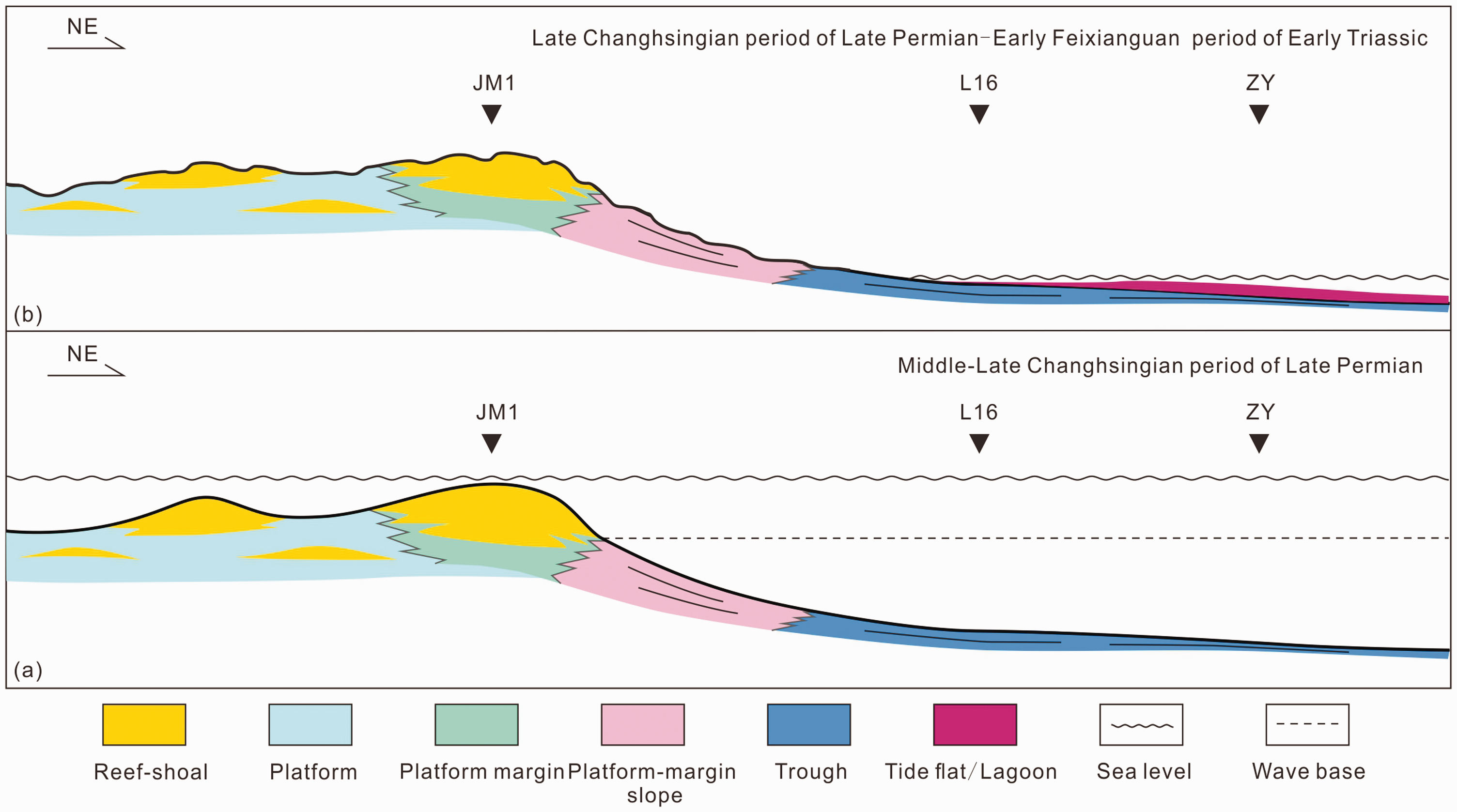
A conceptual model that illustrates the sedimentary pattern evolution from the Middle-Late Changhsingian period to the Early Feixianguan Period in northwestern Sichuan Basin.
Sequence stratigraphic characteristics
Sequence division and analysis of the early filling process
Based on the theory of high-resolution sequence stratigraphy, the Feixianguan Formation is divided into four members, namely the Fei 1 Member that corresponds to three long-term cycles (LSC1-LSC3), Fei 2 Member that corresponds to two long-term cycles (LSC4-LSC5), and Fei 3 and Fei 4 Members that correspond to one long-term cycles (LSC6).
Typical sequence boundaries are mainly exposed in the Yudongliang, Xiaoba, and Zhengyuan Sections. The sequence boundary between the Feixianguan Formation and the Changxing/Dalong Formation has been described above and shown in Figure 2.
Two sets of earthy-yellow calcium crust deposits with thicknesses of about 1 m were observed below LSC1 and LSC4 in the Yudongliang Section, respectively (Figure 5(a) and (b)), and they are very similar to the calcareous nodules in the Tarragona Section of Spain (Mateu and Colin, 1983), both of which provide strong evidence of exposure (Fan and Wen, 1992; Fan and Wu, 2004; Mateu and Colin, 1983; Tandon and Gibling, 1997; Zhou and Chafetz, 2009). The LSC4/LSC5 boundary in the Yudongliang Section separates the underlying earthy-yellow oolitic dolomite from the overlying gray-black micrite (Figure 5(c)); the LSC5/LSC6 boundary in the Xiaoba Section separates the underlying limestone from the overlying purple mudstone and calcareous mudstone intercalated with thin limestone (Figure 5(d)); the boundary between LSC6 and the Jialingjiang Formation in the Xiaoba Section separates the underlying purple-red argillaceous limestone and calcareous mudstone from the overlying gray-brown thin-layer argillaceous limestone, reflecting the transition from base-level fall to rise (Figure 5(e)).
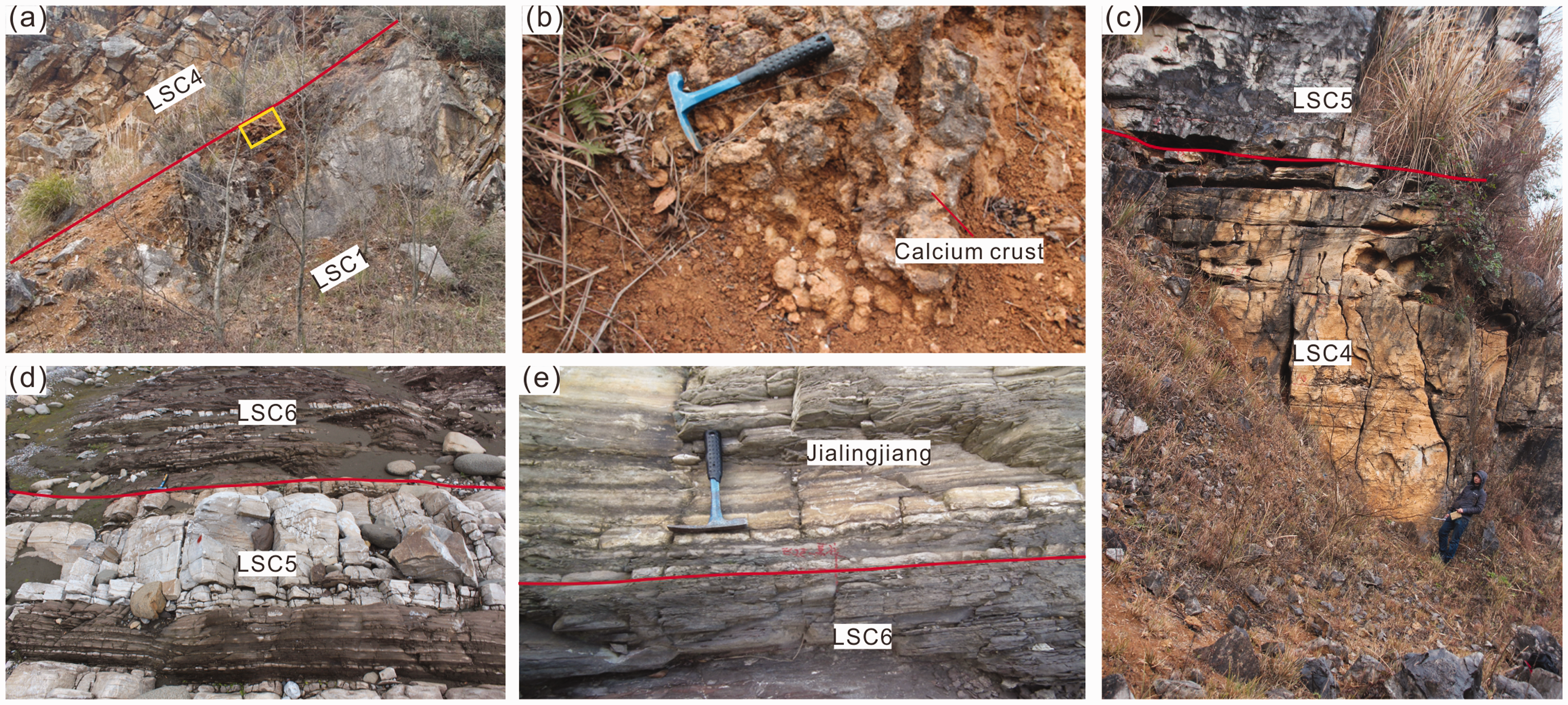
Petrologic characteristics of typical sequence boundaries of Feixianguan Formation in northwestern Sichuan Basin. (a) Yudongliang Section showing macroscopic characteristics of the LSC1/LSC4 boundary; (b) A zoomed-in view of the Yudongliang Section (see its location indicated by the yellow rectangular in Figure 6(a)), calcium crusts on the top of LSC1; (c) Yudongliang Section showing macroscopic characteristics of the LSC4/LSC5 boundary, with earthy-yellow oolitic dolomite on the top of LSC4 and gray-black micrite limestone at the bottom of LSC5; (d) Xiaoba Section showing macroscopic characteristics of the LSC5/LSC6 boundary, which separates underlying limestone from the overlying purple-red mudstone and calcareous mudstone intercalated with thin limestone; (e) Xiaoba Section showing macroscopic characteristics of the boundary between LSC6 and Jialingjiang Formation, with underlying purple-red argillaceous limestone and calcareous mudstone and overlying gray-brown thin-layer argillaceous limestone.
GR logging curves have various forms due to the complexity of topography and provenance of the study area. Meanwhile, seismic events are highly traceable based on the theory of sequence stratigraphy. Accordingly, seismic data were used for constraining the macro-scale framework, while logging curves and lithological changes were analyzed for the sequence boundary identification in the local micro-regions. Taking the section that passes Wells ST18-ST12-SY132-LG69-L16 as an example, certain regularity was reflected by the changes of lithologies, GR curves, and seismic characteristics at the sequence boundary (Figure 6). Specifically, the boundary between LSC1 and the Dalong Formation is accompanied by a transition from finger-like high-GR features to box-like low-GR features as well as strong trough seismic reflection, while that between LSC1 and the Changxing Formation is a set of transgressive argillaceous limestone, which witnessed the rapid positive excursion of GR values and is characterized by strong peak seismic reflection. The boundary between LSC4 and LSC1-LSC3 is also a set of transgressive argillaceous limestone, accompanied by rapid positive excursion of GR values and strong peak seismic reflection. When it comes to the boundary between LSC5 and LSC4, it is a set of transgressive calcareous mudstone, and it is characterized by rapid positive excursion of GR values in all wells except Well L16 as well as strong peak seismic reflection. In terms of the boundary between LSC6 and LSC5, it is a set of transgressive calcareous mudstone, accompanied by rapid positive excursion of GR values and strong peak seismic reflection. The boundary between the Jialingjiang Formation and LSC6 separates the underlying interbedded gypsum and calcareous mudstone from the overlying transgressive calcareous mudstone. This boundary is recognizable in the GR curve, as represented by the transition from the sawtooth-shaped GR curve to the gentle GR curve with low values. However, it is not recognizable in the seismic section due to the unstable seismic reflection.
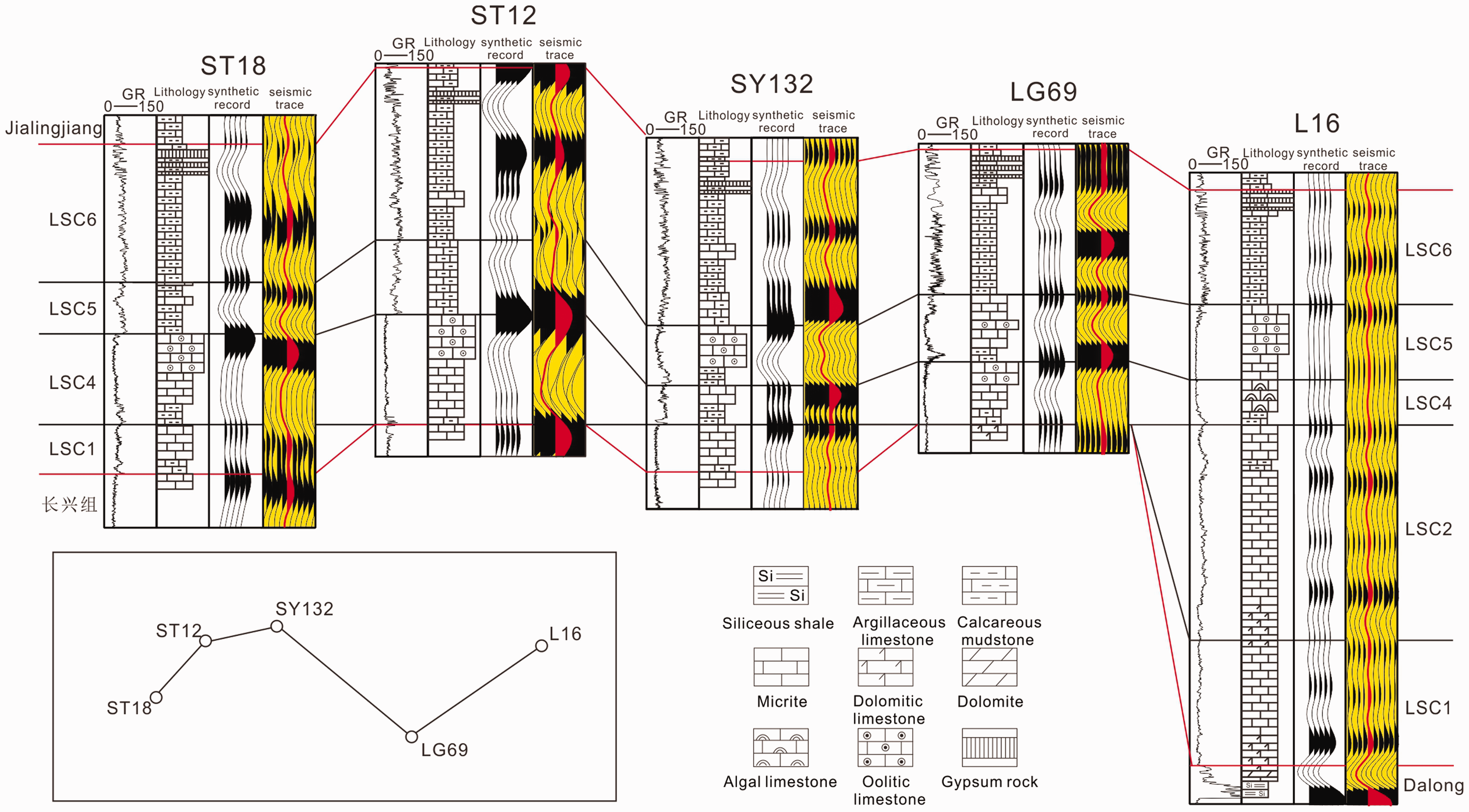
Electrical properties and seismic characteristics of typical sequence boundaries in the study area.
As can be seen from the inter-well correlation, LSC1+LSC2 is thick in the Upper Permian trough area, but its distribution is limited in some depressions in the platform area. Moreover, the top boundary of LSC1+LSC2 is a surface showing filling and leveling-up features. The total thickness of LSC4 and LSC5 varies greatly laterally, and LSC4 and LSC5 present features of complementary deposition. The thickness of LSC6 is relatively stable laterally.
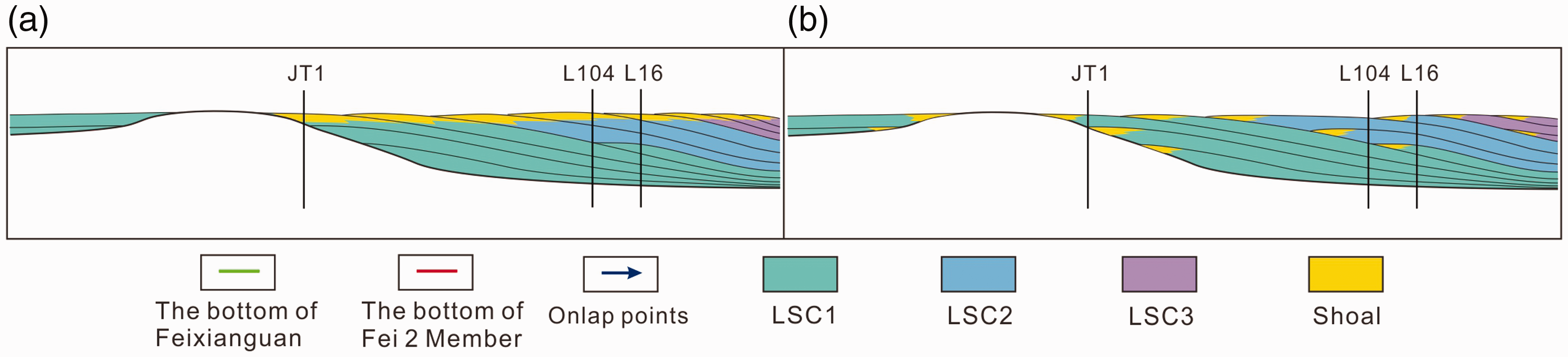
Seismic interpretation is implemented on the line AA’ that passes Wells JM1, JT1, L104, and L16 in the Jiange-Jiulongshan Area(Figures 1 and 7), As the topography was basically uniform at the end of the Feixianguan Period (Ma et al., 2005; Wei et al., 2004), the entire Fei 4 Member was deposited in a semi-confined evaporative environment, with a regionally stable thickness. Therefore, the bottom boundary of the Fei 4 Member has been widely used as the datum to reconstruct the paleotopography before the deposition of the Feixianguan Formation. Taking the AA’ section as an example, it was found through fine interpretation and tracking of seismic events that the bottom boundary of LSC4 (corresponding to the lower sub-member of Fei 2 Member) could be approximated as a filling surface (Figure 7(a)). Below the surface is the Fei 1 Member that corresponds to LSC1-LSC3, whose thickness varies greatly due to the great topographic difference from the platform to the trough during the Changhsingian Period. Beyond this surface lies LSC4 that has a relatively regionally uniform thickness. Furthermore, LSC5 and LSC6 have even more regionally uniform thickness than LSC4.
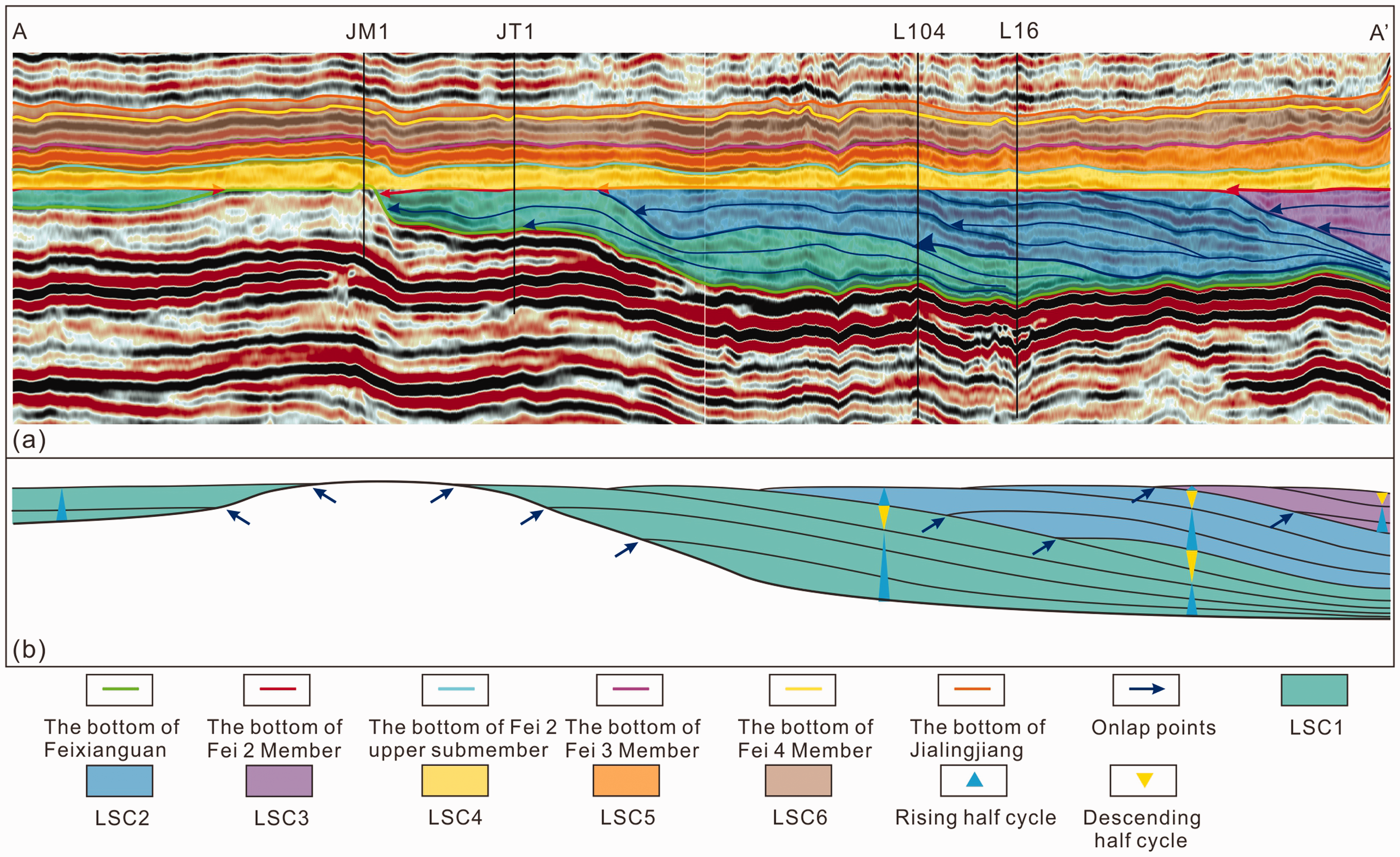
Sequence division of the Feixianguan Formation and the conceptual model of the early filling and leveling-up process. (a) Long-term cycle division in the Feixianguan Formation on the AA’ section and analysis of the early filling process; (b) The slowly rising-fast falling base level that resulted in the Fei 1 Member (LSC1+LSC2+LSC3)
It was found through the further interpretation of the interior of the Fei 1 Member that the slowly rising base level regularly alternated with the rapidly falling base level, and the filling process that reduced the topographic difference at the end of the Changhsingian Period was not the result of continuous aggradation towards the trough. During the deposition of LSC1, the slowly rising base level resulted in the gradual overlapping of the Changxing Formation over the slope and platform. After rising and approaching the platform, the base level started to decline rapidly, reaching a lower level in a short time period. Similarly, this base level rising-and-falling process repeated through time, leading to the gradual filling of LSC2 and LSC3 towards the trough. Eventually, the terrain was filled and leveled up (Figure 7(b)).
Planar distribution of thickness of key sequences
Since the trough developed during the Changhsingian Period was largely filled by LSC1-LSC3, it was feasible to reconstruct the paleotopography prior to the deposition of the Feixianguan Formation using the impression method, which could also to a certain extent reflect the paleotopography before the deposition of the Fei 2 Member. The top and bottom boundaries of the Fei 1 Member were delineated on the high-quality two- and three-dimensional seismic sections (Figure 8), which was then integrated with well data, outcrop sections, stratigraphic-sedimentary correlation (Figure 9), and tectonic setting, to make the thickness map of the Fei 1 Member (Figure 10(a)). In general, the Fei 1 Member is thick (>200 m, with local thickness reaching 800 m) in the Guangyuan-Wangcang Area, Anxian-Yanting Area, and the northwestern part outside the basin, whereas it is thin (<200 m) in the Jiangyou-Jiange-Langzhong-Yilong Area, where the Fei 1 Member is even locally absent.
The thickness map of the Fei 1 Member in the northwestern Sichuan Basin.
Correlation analysis of stratigraphic-sedimentary features.
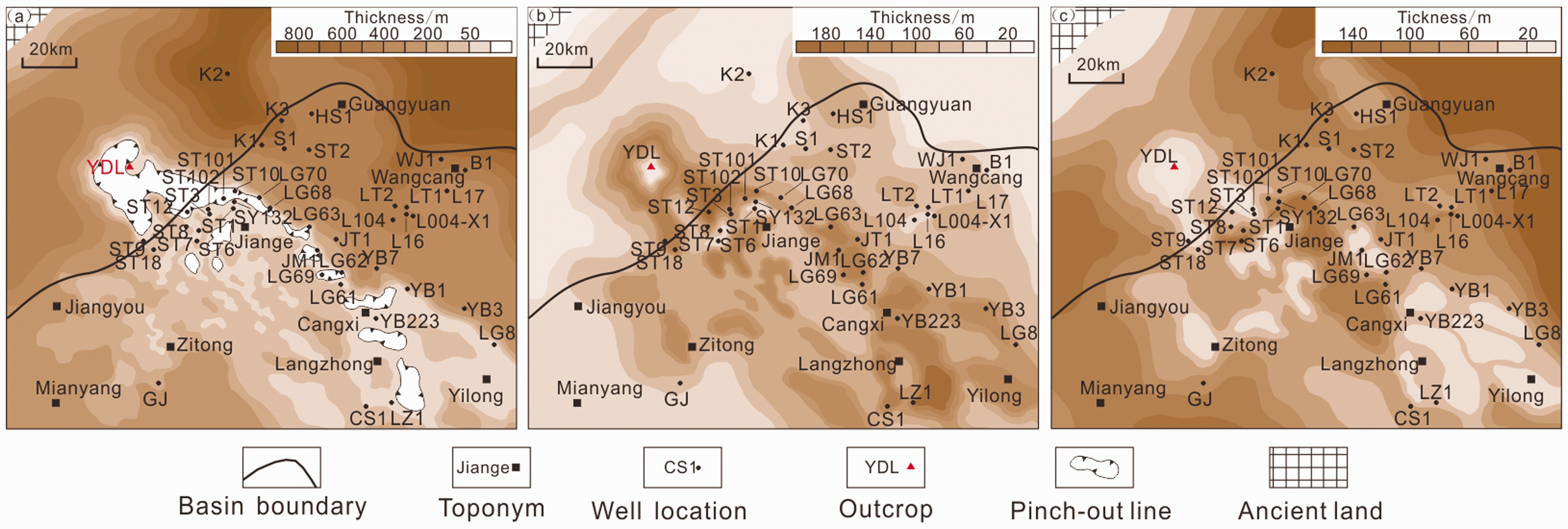
Thickness maps of key sequences of the Feixianguan Formation in northwestern Sichuan Basin. (a) Thickness map of the Fei 1 Member; (b) Thickness map of the lower submember of the Fei 2 Member; (c) Thickness map of the upper submember of the Fei 2 Member.
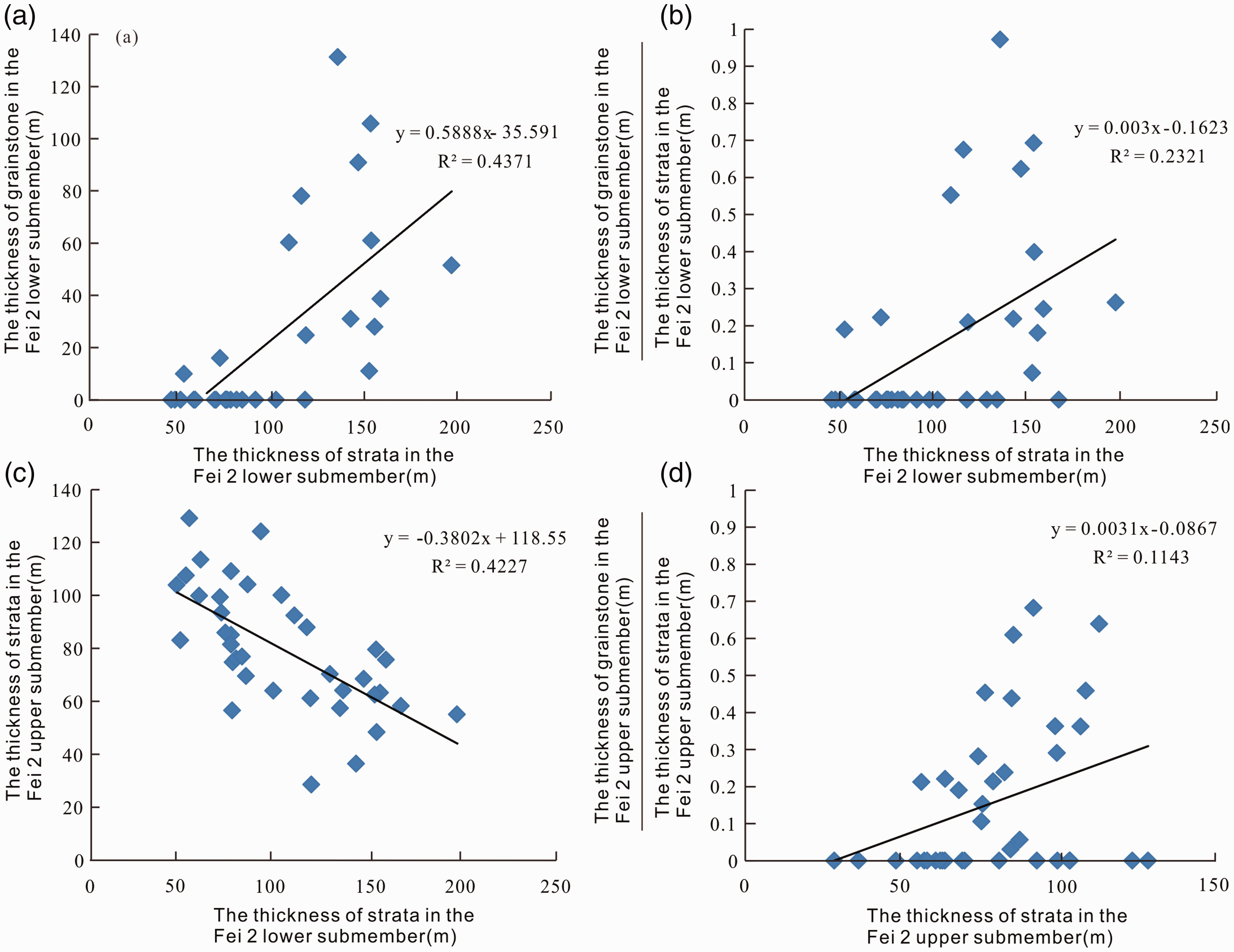
It was found through statistics that the thickness of the lower submember of the Fei 2 Member is positively correlated with both the thickness of the grainstone and its ratio to the total strata thickness (Figure 9(a) and (b)). Therefore, it could be inferred that the water body should be relatively open during the depositional period and the hydrodynamics at the locally present highlands should be strong, which contributed to the large total strata thickness and the thick shoal body thickness. The thickness map of the lower submember of the Fei 2 Member was made based on the paleotopography after the deposition of the Fei 1 Member (Figure 10(b)), which shows an opposite trend to that of the Fei 1 Member. Specifically, the Fei 2 Member is thick (>60 m, with local thickness reaching 180 m) in the Jiangyou-Jiange-Langzhong-Yilong Area, whereas it is thin (<60 m) in the Guangyuan-Wangcang Area and the area to the north of Anxian-Yanting Area.
The thickness of the upper submember of the Fei 2 Member is found to be negatively correlated with that of the lower submemeber (Figure 9(c)), whereas it is positively related to the proportion of the thickness of the grainstone in the total strata thickness (Figure 9(d)). Therefore, it could be inferred that the sedimentary period of the upper submember of the Fei 2 Member should be a relatively regressive stage, which means limited accommodation in the highlands of the micro-regions and consequent thin strata thickness. As the water deepened toward the seaside, the strata became thicker and the proportion of the grainstone became larger, presenting typical features of the filling and leveling-up process. Subsequently, the thickness map of the upper submember of the Fei 2 Member was made based on the paleotopography before the deposition of the lower submember of the Fei 2 Member (Figure 10(c)), which shows an opposite trend to that of the lower submember of the Fei 2 Member. Specifically, the upper submember is thick (>100 m, with local thickness reaching 140 m) in the Guangyuan-Wangcang Area and the area to the north of the Anxian-Yanting Area, whereas it is thin (20–100 m) in the Jiangyou-Jiange-Langzhong-Yilong Area.
Lithofacies paleogeographic reconstruction
Feixianguan Formation as a possible product in the carbonate ramp
Relatively flat topographical conditions during the early Feixianguan period
The carbonate slope between the platform and the trough was observed to be gentle (0.8°–2.6°) during the Late Changhsingian Period based on the calculation of the slope in the AA’ section (Figure 5(a)). Moreover, the slowly rising base level during the Feixianguan Period gradually filled the topographic difference. Therefore, the sedimentary base for the Feixianguan Formation was very flat.
Absent sedimentary characteristics of platform margin in the progradation of the Fei 1 member
Shoal bodies were not encountered during the drilling of Wells L104 and L16 in the Upper Permian trough area, although there were obvious clinoforms on the top of the Fei 1 member. Moreover, these clinoforms were observed to consist of argillaceous limestone and dolomite limestone that indicate restricted, low-energy environments, which are obviously different from the characteristics of the high-energy clinoforms in the platform margin (Figure 11(a)). It is therefore speculated that the Feixianguan Formation in the northwestern Sichuan Basin should be deposited in the continuous, gentle carbonate ramp (Figure 11(b)), based on the analysis of the filling process during the deposition of the Fei 1 Member. In this context, it is reasonable that high-energy shoal bodies were not encountered in Wells L104 and L16, since they should be developed in the nearshore high-energy zone rather than in the slope area.
Analysis of depositional features and establishment of depositional models for the Feixianguan Formation in northwest Sichuan Basin. (a) depositional model of the prograding shoal body in the platform margin during deposition of the Fei 1 Member; (b) depositional model of the shoal body in the gentle slope during deposition of the Fei 1 Member.
Sedimentary characteristics
Main sedimentary facies types and characteristics
The Feixianguan Formation in the northwestern Sichuan Basin is divided into three main facies belts based on structure and sequence filling features observed in cores, thin sections, and outcrops, namely the inner ramp, mid-outer ramp, and basin facies belts. Specifically, the inner ramp could be further divided into the shoal and tidal flat/lagoon subfacies. Moreover, the tidal flat/lagoon subfacies could be further divided into the mixed type and the carbonate type, depending on the intensity of terrestrial input.
Inner carbonate ramp facies belt. The inner carbonate ramp facies belt is located in the shallow-water area near the shoreline, mainly consisting of shoals and tidal flats/lagoons. Shoal bodies are generally developed in subtidal zones, and they were frequently disturbed by waves to form relatively high-energy deposits. In the study area, oolitic shoals take dominance (Figure 12(a)). Tidal flats/lagoons are generally developed in relatively still-water areas in the intertidal and supratidal zones or in the areas below the wave base. Ripple marks are common. This facies belt mainly consists of micrite limestone, argillaceous limestone, and calcareous mudstone (Figure 12(b) and (c)).
Main sedimentary facies types of the Feixianguan Formation in the northwestern Sichuan Basin. (a) Well LT2, 5361.94–5362.04 m, Fei 2 Member, oolitic shoal, sparry oolitic limestone, plane-polarized light; (b) Xiaoba Section, mixed tidal flat/lagoon, ripple marks; (c) Xiaoba Section, carbonate tidal flat/lagoon; (d) Feixianguan Section in Shangsi Area, mid-outer ramp, dark-gray thin-layer calcareous mudstone and argillaceous limestone.
Middle-outer carbonate ramp facies belt. The mid-outer carbonate ramp facies belt is generally located in a relatively deep water environment below the wave base and facing the open sea. The middle and outer carbonate ramps were analyzed as an entirety since they are not easy to be distinguished from each other in the study area. This facies belt mainly consists of dark-gray, gray-black thin-layered argillaceous limestone (Figure 12(d)).
Basin facies belt. The basin facies belt is mainly located in deepwater environment greater than 200 m, sharing similar sedimentary features with the mid-outer ramp facies belt. This facies belt was speculated to be mainly developed in the northwestern margin of the Upper Yangtze Platform and the northern margin near the open sea area.
Vertical and lateral characteristics of sedimentary facies
It was found through inter-well correlation in the southwest-northeast direction that the deposits from the bottom to the top of the Feixianguan Formation were gradually “homogenized” (Figure 13). Specifically, the trough-platform system developed during the Changhsingian Period was gradually leveled up during the deposition of the Fei 1 Member. At that time, mid-outer ramp deposits took the dominance, and meanwhile, sedimentary hiatus was observed in the paleo-highlands of Wells LG69 and JM1. The topographic difference was further reduced during the deposition of the Fei 2 lower submember, leading to thick, inner-ramp oolitic shoal deposits in the paleo-highlands (Wells LG69, JM1, and JT1) under the background of relative transgression. Relative regression occurred during the deposition of the Fei 2 upper submember. Meanwhile, shoal bodies migrated to the deep-water parts (Wells L104, L16, L17, and B1) as controlled by the change of accommodation, during which the topography was leveled up again. A mixed tidal flat with a relatively stable thickness was formed on the relatively flat terrain due to the input of a mass of terrestrial source during the deposition of Fei 3 and Fei 4 Members.
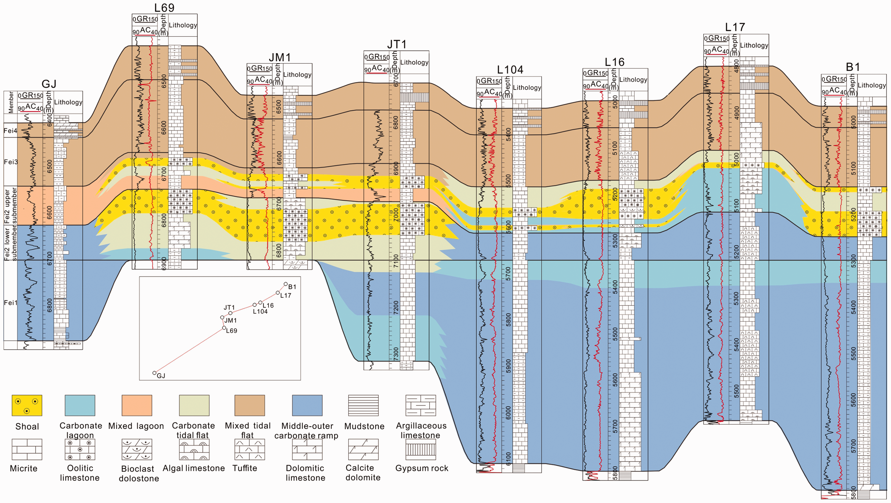
Inter-well correlation of sedimentary facies of the Feixianguan Formation.
Distribution and evolution characteristics of lithofacies paleogeography during shoal-forming periods
Lithofacies paleogeography during main shoal-forming periods was reconstructed using the strata thickness as the main single factor (Zhong et al., 2017) based on considerations of the tectonic background.
Specifically, the Kaijiang-Liangping Trough developed during the Late Changhsingian Period was already filled to a large extent during the deposition of the Fei 1 Member (LSC1-LSC3). Restricted inner ramp with extremely shallow water bodies dominated the highlands in the Zitong, Jiange, and Langzhong Areas, where tidal flats, lagoons, and shoals were developed and some micro-areas were exposed and thus received no deposits. Mid-outer ramp and basin facies belts gradually took dominance towards the lowlands in the northern Guangyuan and Wangcang Areas and the southern Mianyang Area (Figures 14(a) and 15(a)).
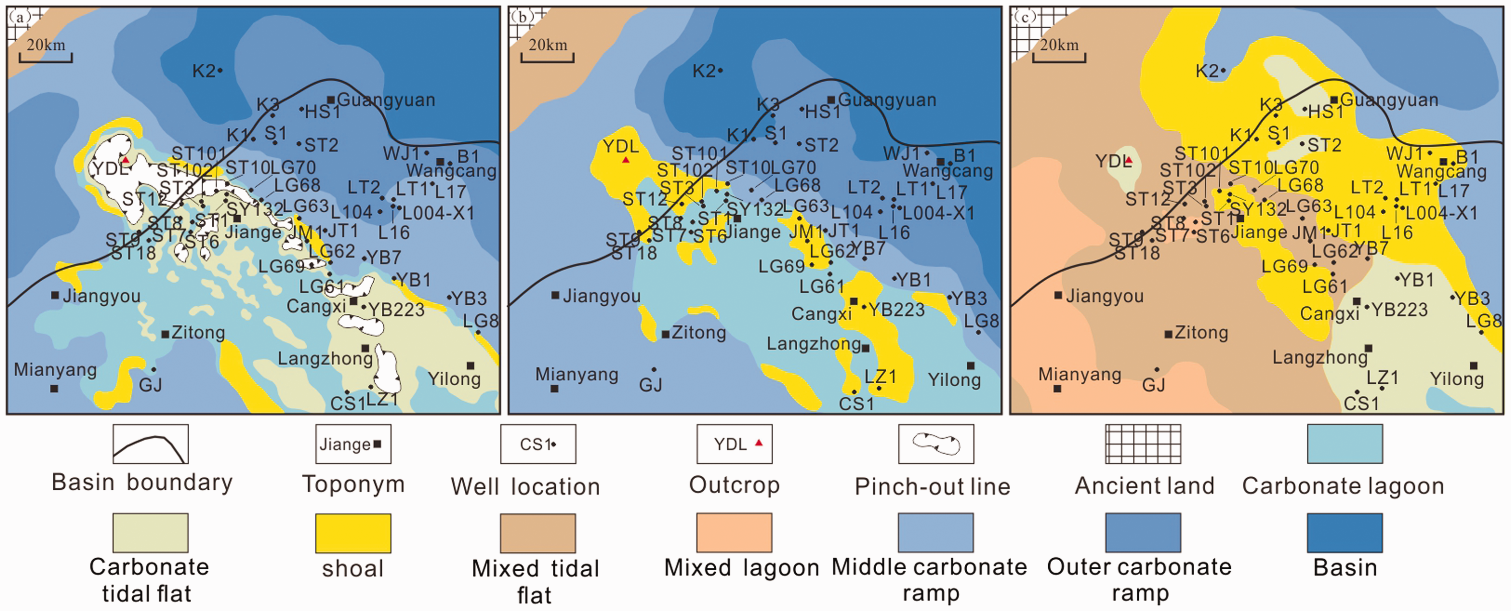
Lithofacies paleogeography in northwestern Sichuan Basin during main shoal-forming periods. (a) Lithofacies paleogeography during deposition of the Fei 1 Member; (b) Lithofacies paleogeography during deposition of the Fei 2 lower submember; (c) Lithofacies paleogeography during deposition of the Fei 2 upper submember.
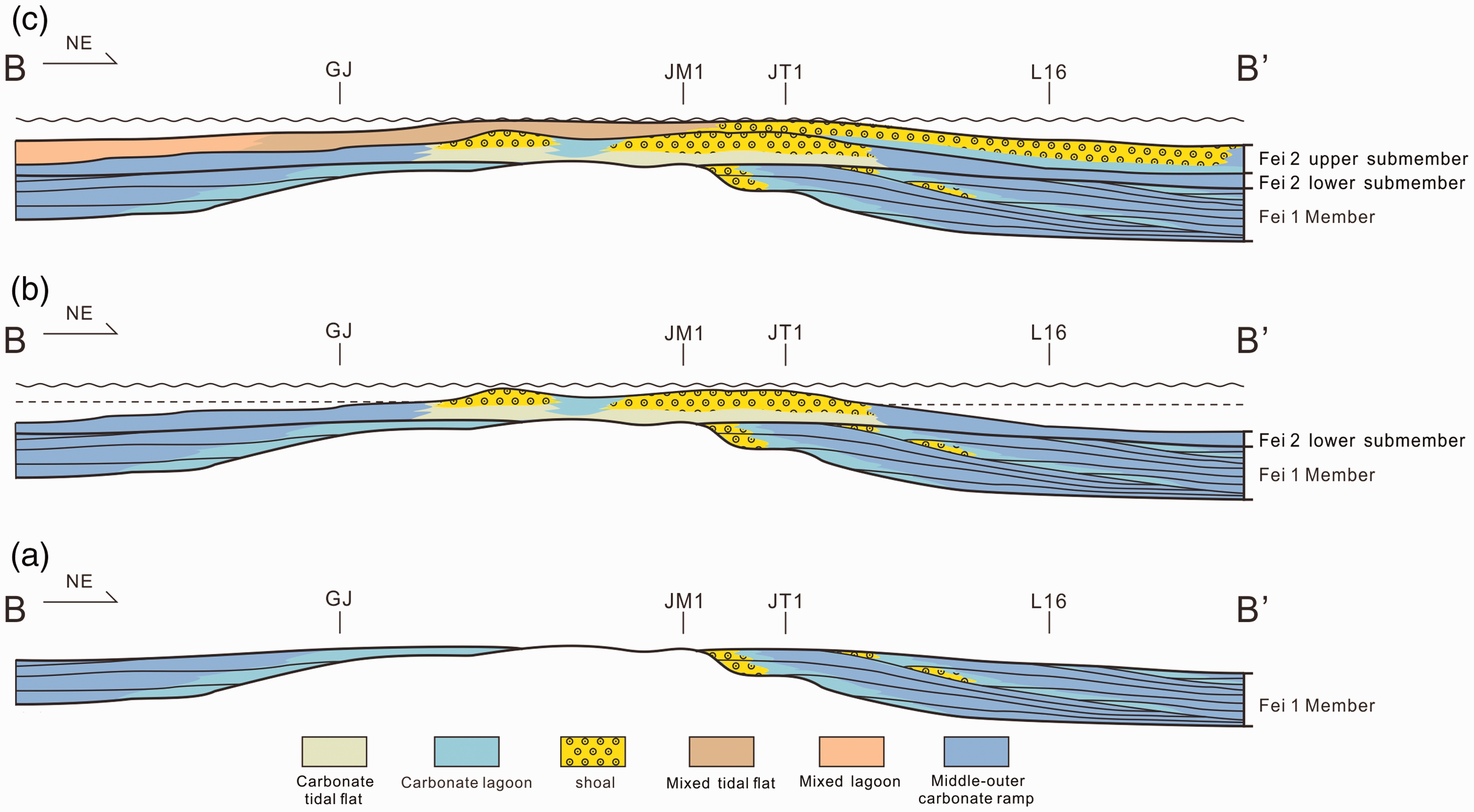
Sedimentary evolution model in the northwest Sichuan Basin during main shoal-forming periods (see section locality in Figure 1).
The tectonic activity was strengthened during the depositional period of the Fei 2 lower submember (LSC4), when the Longmenshan island chain on the northwestern margin of the Upper Yangtze was further uplifted. At that moment, the terrestrial source had already affected the western part of the study area. With the advancement of the relative transgression in the study area, the water body became open and the facies belts retrograded in general. Shoal bodies were inheritably developed on the micro-topographic highlands at the end of the depositional period of the Fei 1 Member. The inner ramp had a smaller area than that during the depositional period of the Fei 1 Member, and it was still concentrated in the Zitong, Jiange, and Langzhong Areas (Figures 14(b) and 15(b)).
During the depositional period of the Fei 2 upper submember (LSC5), the uplifting of the Longmenshan island chain on the west and the Kangdian ancient land in the southwestern Sichuan Basin intensified, leading to an overall regressive process. A large number of terrigenous materials were input into the study area from west to east, causing the mixed tidal flat and lagoon environment in the Mianyang-Zitong-Jiange Area. Meanwhile, the carbonate deposition was shifted northeastwards to the Guangyuan, Wangcang, and Langzhong Areas. Specifically, large-scale ramp shoal bodies were developed in the Guangyuan-Wangcang Areas. The topography gradually became flat after the deposition of the Fei 2 upper submember (Figures 14(c) and 15(c)).
Geological and natural gas exploration implications
Differences in the depositional patterns of the Feixianguan Formation in northwestern Sichuan and northeastern Sichuan were preliminarily analyzed in this study. Under the tectonic background of MianLue Ocean expansion in the northern margin of the Yangtze Plate during the Middle to Late Permian, the northern Sichuan area was in a tensile stress environment. According to the previous research on the distribution of basement faults (Li, 1995), the No. 16 basement fault inside the trough obliquely intersected the trough, and the syn-sedimentation associated with the tension of this basement fault probably determined the landforms of the Kaijiang-Liangping Trough and its periphery. The oblique intersecting relationship between the basement fault and the trough resulted in the uneven force during the extension of the fault, leading to the gentle fault surface in the northwest part of the trough and the steep fault surface in the eastern part of the trough. These fault features controlled the extensional form of the Kaijiang-Liangping Trough, resulting in the small extensional subsidence and thus relatively flat landforms in the northwest part of the trough as well as large syn-sedimentary extensional subsidence and thus relative steep landforms in the northeast part of the trough. Therefore, sedimentary landforms of different slopes were formed in different areas on both sides of the trough under the control of basement faults. Such differentiated landforms were inherited during the Feixianguan Period, forming the ramp oolitic shoals in the northwestern Sichuan Basin and the platform-margin oolitic shoals in the northeastern Sichuan Basin.
From the perspective of exploration, clinoforms in the platform margin belt were suggested to be the most favorable areas for the development of large-scale and high-quality reservoirs in the previous research. Accordingly, existing exploration has been mainly focused on finding multi-stage platform margin belts, the results of which have confirmed the rationality of the deposition model developed in the previous research. However, such a model does not apply to the Feixianguan Formation in the vicinity of the Huankaijiang-Liangping Trough of the northwestern Sichuan Basin. As a countermeasure, this study proposed a continuous continental carbonate ramp model based on the actual geological conditions in the northwestern Sichuan Basin. Specifically, it was explicitly pinpointed that the platform margin belt was not the only favorable belt for the development of large-scale and high-quality reservoirs, while the shoal bodies formed in the filling and leveling-up process were also potential in acting as large-scale reservoirs. Moreover, the oolitic shoals have wider areas than the platform margin belts, revealing the huge exploration potential of the Feixianguan Formation in the northwestern Sichuan Basin. In this context, there could be possibly large-scale gas reservoir belts hosted by the Feixianguan Formation in the northwestern Sichuan Basin. The results of this study act as a new supplement to the existing classic trough-platform margin shoal-forming model, and the exploration direction will no longer be limited to searching for slope breaks at the platform margin. Future research will focus on comprehensively predicting the distribution of oolitic shoals using the information of strata thickness and seismic attributes from the perspective of finely describing the sedimentary micro-topography of each major shoal-forming period. In this way, the probability of success will be greatly enhanced in finding large-scale oolitic shoal reservoirs, which would provide a breakthrough direction for the exploration and development of the reef and shoal reservoirs in the Sichuan Basin.
Conclusions
A large regional regression occurred at the end of the Late Permian, which led to the evolution of the original Kaijiang-Liangping Trough into an extremely shallow tidal flat/lagoon environment in the Early Triassic. The sedimentary pattern of the Early Triassic was completely different from that of the Late Permian. A total of six long-term cycles were identified in the Feixianguan Formation of the northwestern Sichuan Basin, which correspond to the Fei 1 Member (LSC1-LSC3), Fei 2 lower submember (LSC4), Fei 2 upper submember (LSC5), Fei 3 and Fei 4 Members (LSC6), respectively. The topography was already to a large extent leveled after the deposition of the Fei 1 Member, and it was further smoothened after the deposition of the Fei 2 Member. The Feixianguan Formation in the northwestern Sichuan Basin might be formed in the continuous continental carbonate ramp with no high-energy platform-margin belts. The main shoal-forming periods corresponded to the deposition of Fei 1 and Fei 2 Members, respectively. With the intensified uplift of the Longmenshan island chain on the west side and the Kangdian ancient land in the southwestern Sichuan Basin, a large number of terrigenous materials were input into the study area from west to east. Consequently, the mixed depositional features gradually became obvious, and the clear-water carbonate sedimentary facies belt moved eastward, forming large-scale continuously-distributed inner ramp shoal deposits in the Guangyuan-Wangcang Area. Platform margin belt was suggested to be not the only favorable area for the development of large-scale high-quality shoal reservoirs. Instead, the shoal bodies formed in the filling and leveling-up process were speculated to be also favorable for the development of large-scale reservoirs. Moreover, the oolitic shoals have wider areas than the platform margin belts, revealing the huge exploration potential of the Feixianguan Formation in the northwestern Sichuan Basin.
Footnotes
Declaration of conflicting interests
The author(s) declared no potential conflicts of interest with respect to the research, authorship, and/or publication of this article.
Funding
The author(s) received no financial support for the research, authorship, and/or publication of this article.