
Abstract
There are abundant geothermal resources in the Xiong’an New Area, China. However, the thermal state and geothermal energy accumulation mechanism are not clear. Based on the geological conditions and the characteristics of the present geothermal field, a 2D model was established to analyze the process of mantle-derived heat conduction and to predict the distribution of the deep geothermal field. We calculated the terrestrial heat flow for the Rongcheng uplift and Niutuozhen uplift to be 64 and 75 mW/m2, respectively. The geothermal resources in this area are controlled by a four-element model comprising heat conduction, structural uplift, large deep fractures, and convection within the reservoir.
Keywords
Introduction
Geothermal resources are increasingly of interest to diverse communities due to their low-cost, sustainable and eco-friendly characteristics. The development and utilization of geothermal resources is of great significance for improving the energy structure and solving increasingly serious global environmental problems (Wang et al., 2017a). The Xiong’an New Area has the most abundant geothermal resources in eastern China (Wang et al., 2017b; Zheng, 2015). In particular, in the Niutuozhen uplift and Rongcheng uplift, extremely abundant geothermal resources characterize the Xiongxian geothermal field and Rongcheng geothermal field. These resources have created great social and economic benefits with the development of geothermal energy exploitation (Zhang et al., 2013). Scholars have conducted many studies on the geology, geophysics, geochemistry, hydrology, drilling engineering, and other aspects of the geothermal resources in the Xiong’an New Area (Chen, 1988; Li et al., 2014, 2017; Pang et al., 2011). The characteristics of the regional geology, deep fractures, and main reservoir have been clarified. On this basis, Pang et al. (2015) proposed two heat transfer mechanisms for the geothermal resources in the Xiong’an New Area: heat conduction and heat convection. However, the existing research mainly focuses on shallow heat reservoirs, and the scope is usually limited to the periphery of the geothermal field. There are few studies on the deep thermal state and the heat accumulation mechanism at wider and deeper ranges.
Numerical simulation methods can comprehensively study the influence of formation heat transfer, fluid heat transfer and radiative heat generation on the geothermal field and predict the distribution of the deep temperature field. At present, there are few numerical simulation studies on the Xiong’an New Area; only Pang et al. (2011) established the horizontal fracture medium model of the Xiongxian geothermal field and predicted the recovery concentration and peak value of a tracer in well group tracer tests. The above studies focus only on the shallow reservoir system. The mechanisms of thermal conduction from the deep mantle source and the thermal conduction of deep faults remain unknown.
Based on the geological conditions and the characteristics of the present geothermal field in the Xiong’an New Area, we established a two-dimensional hydrothermal coupling model to analyze a four-element model comprising heat conduction, structural uplift, large deep fractures and convection within the reservoir, and we use this model to predict the distribution of the deep geothermal field. The results provide a reference for the development and utilization of the regional geothermal resources in the Xiong’an New Area.
Geological conditions
Geothermal characteristics
The study area is located in the north of the Jizhong depression (III level) in the Bohai North China basin (II level) on the Sino Korean paraplatform (I level), and in term of grade IV structural units, the study area includes the Rongcheng uplift, Langfang-gu’an sag, Niutuozhen uplift and Baxian sag (Yu et al., 2017). The main thermal conductivity fractures in the region are Niudong and Rongcheng fractures (Pang et al., 2018; Wang et al., 2016; Figure 1).
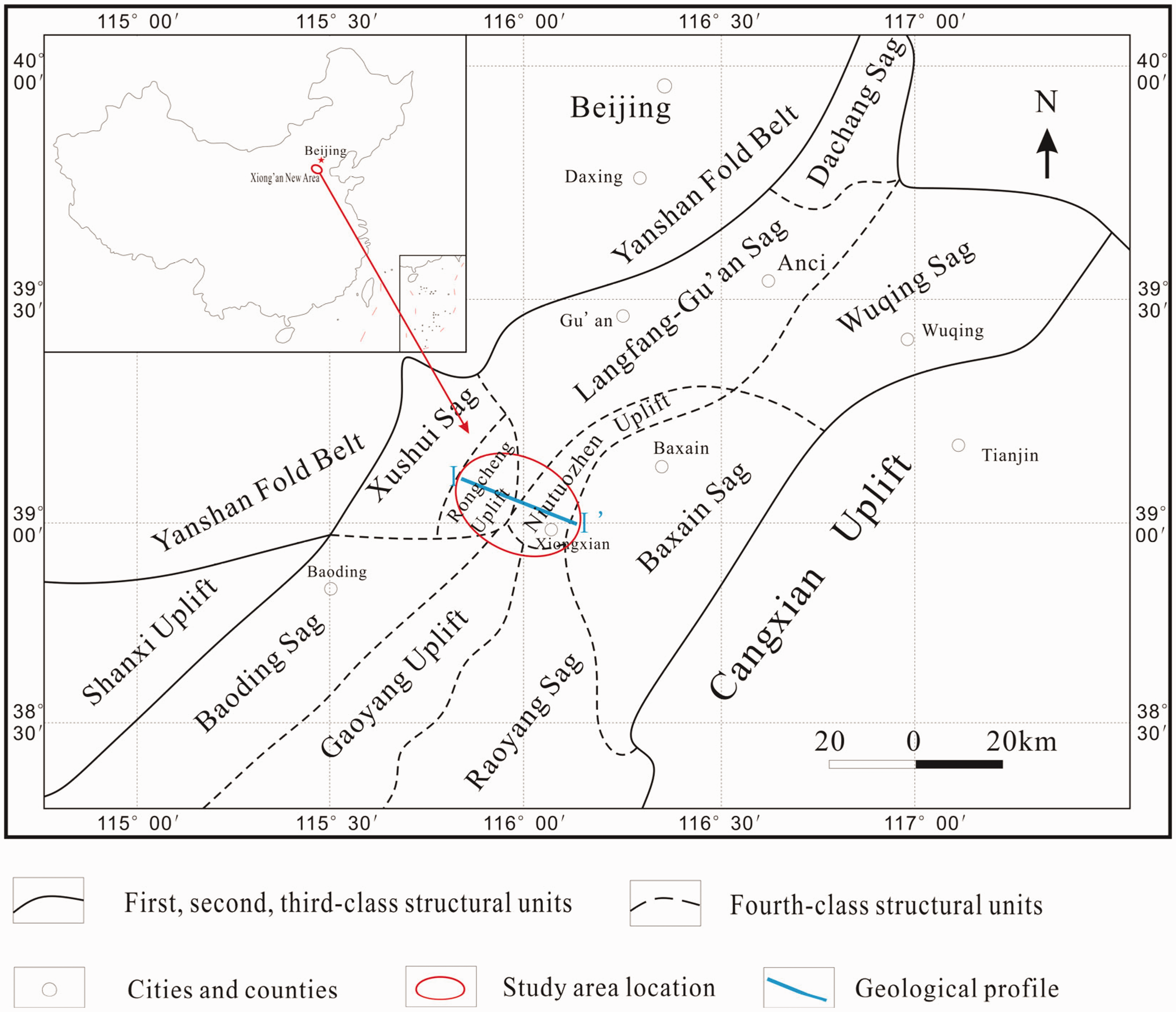
Structural map of the study area (from Zhang et al., 2017).
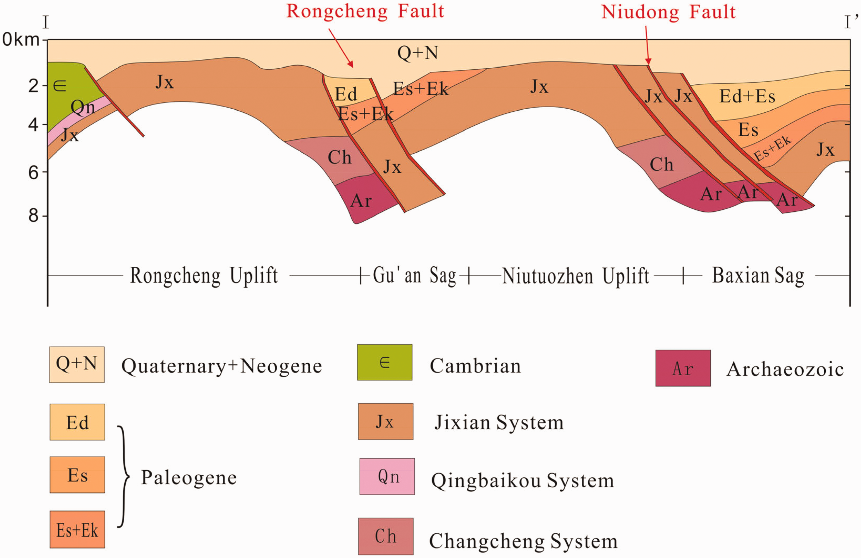
Geological profile of the study area (from Pang et al., 2018).
The depth of the Moho in this area is 35–38 km and gradually becomes shallower from the northwest to the southeast. The depth of the Curie interface is 18–20 km, with shallow burial in the middle and deeper burial at the edge. Preliminary data show that the terrestrial heat flow is between 79.1 and 90 mW/m2, and the geothermal gradient is generally 3.0–8.0°C/100 m, with a maximum value of 12.6°C/100 m (Chen et al., 1995).
The distribution of Cenozoic units in the uplifts and sags shows drape sedimentation. The quaternary and upper tertiary sandstone units are nearly horizontal, and the lower tertiary units have gentle dips. The lower strata mainly include Ordovician, Cambrian, Jixian, and Changcheng limestone and Archean metamorphic rocks (Li et al., 2014); Figure 2.
Geothermal reservoir
There are two types of reservoirs in this area: pore reservoirs and bedrock fissure karst reservoirs. The thermal pore reservoir is mainly composed of the Neogene Minghuazhen and Guantao formations. The Minghuazhen formation has a wide distribution range, while the Guantao formation is only distributed along the edge of the Niutuozhen uplift. The bedrock fissure karst reservoirs are the main reservoirs. In the Niutuozhen uplift, the Jixian Wumishan formation is the main reservoir, and in the Rongcheng uplift, the Changcheng Gaoyuzhuang formation is the main reservoir (Guo and Li, 2013).
The variations in the thermal conductivity of the formations and large deep faults are the main factors controlling the geothermal resources in the study area. The surrounding thick rock cover with low thermal conductivity hinders heat conduction. The high thermal conductivity in the uplift region provides favorable conditions for heat flow and causes the heat to accumulate in the uplift region. The Niudong fault and the Rongcheng fault interact with the deep heat source and play a role in heat conduction. Tertiary and quaternary sediments are caprocks with low porosity, permeability, and thermal conductivity. These factors contribute to the rich geothermal resources in the Xiong’an New Area.
Model building
Hydrothermal migration is a necessary condition for shallow geothermal resources. Based on geological conditions, this study mainly considers the mechanism of deep heat accumulation and the natural density differential convection process and establishes a 2D profile model of the Xiong’an New Area (Figure 3). The top of the model is a constant temperature boundary, the bottom is a constant heat flux boundary and the side boundaries are open boundaries.
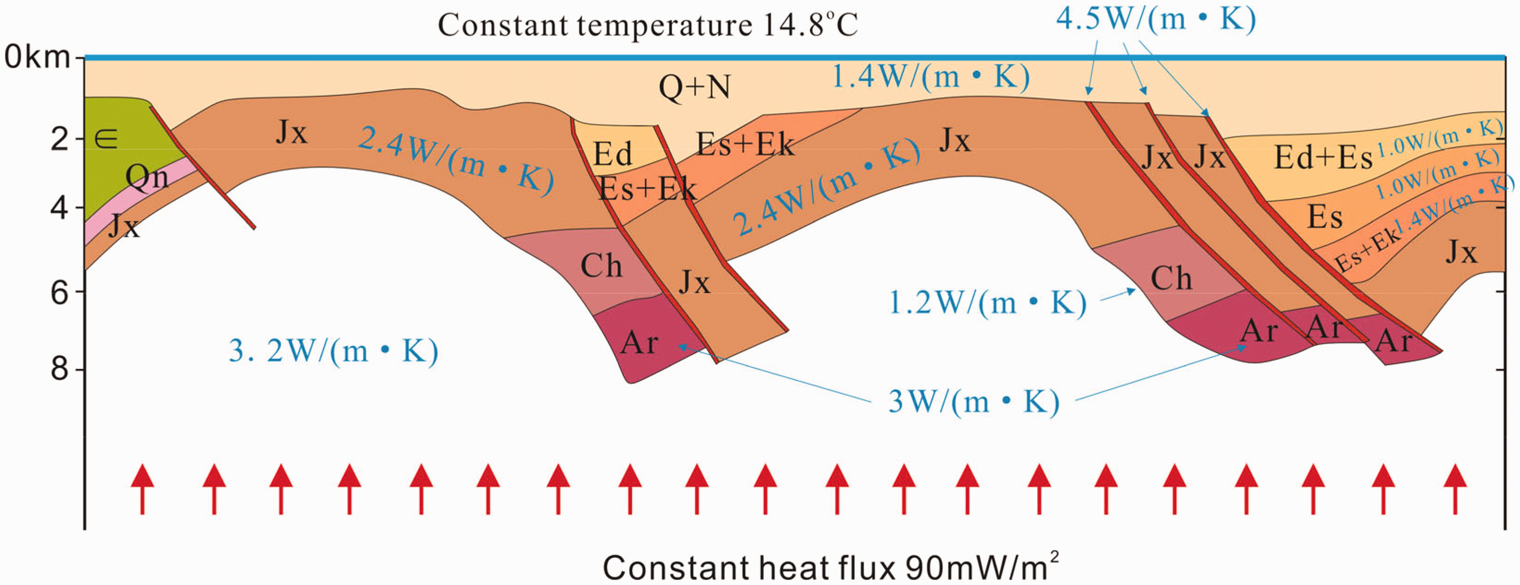
Conceptual model diagram.
Mathematical model
The mathematical model of heat conduction is established as follows


The Brinkman equation is used to describe the water convection

Coupling software
COMSOL is a large and advanced numerical simulation software, which is widely used in scientific research and engineering calculation in various fields, and can simulate various physical processes. It has efficient calculation performance and excellent direct coupling analysis ability of multiple fields, and realizes high-precision numerical simulation.
In this paper, we defined a temperature-dependent force that causes fluid flow, which in turn causes convective heat transfer and affects temperature distribution. Two-way coupling of flow and heat transfer is achieved by COMSOL software.
Critical parameters
The data show that the thermal flow value at the bottom of the study area is 90 mW/m2, which is stable and evenly distributed. The constant temperature is 14.8°C at the top.
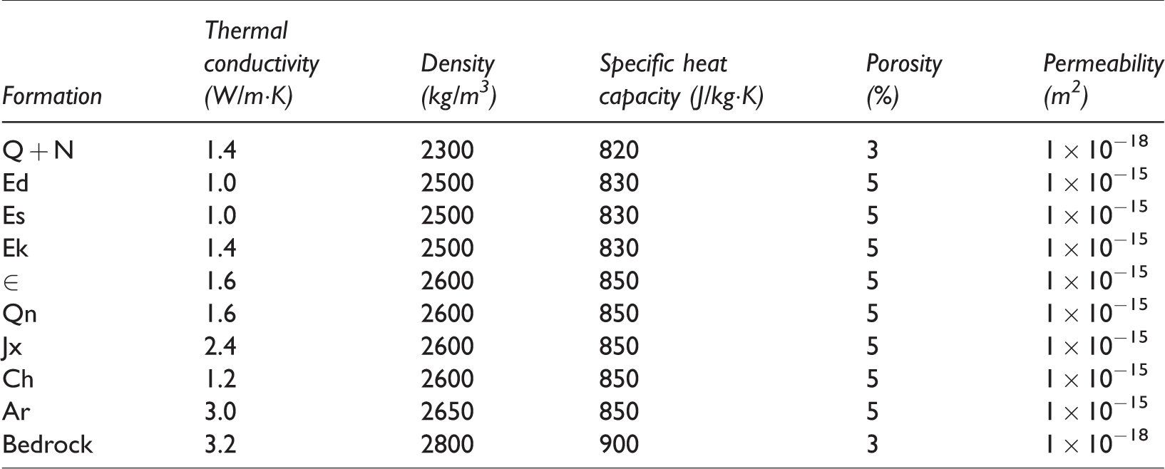
The thermal conductivity of the bedrock, the main heat reservoir, and the caprocks are 3.2, 2.1–2.7, and 1.4 W/m·K, respectively (Wang et al., 2017b). The faults have a higher thermal conductivity of 4.5 W/m·K. The porosity of the main reservoir is approximately 5%, and the permeability is approximately 1 × 10⁻¹⁵ m2. Detailed parameters are shown in Table 1.
Physical property parameters of the formations.
Initial condition and discretization
In this paper, the process of heat transfer from the base to the shallow part is studied, focusing on deep heat conduction, intralayer convection, and the thermal control mechanisms of fractures and uplifts under natural conditions and ignoring the impacts of human activities and geological events such as volcanic eruptions. The initial temperature field model is set at 14.8°C, and the initial pressure is obtained by hydrostatic pressure balance.
We used a triangulation grid to accurately describe the thermal conduction process in the fractures. The mesh was constructed at the fracture site, and a total of 5925 domain units and 979 boundary elements were obtained (Figure 4). The simulated total time was determined according to the results of the ground temperature field calibration (2 million years in this study), and the time step was 10,000 years.
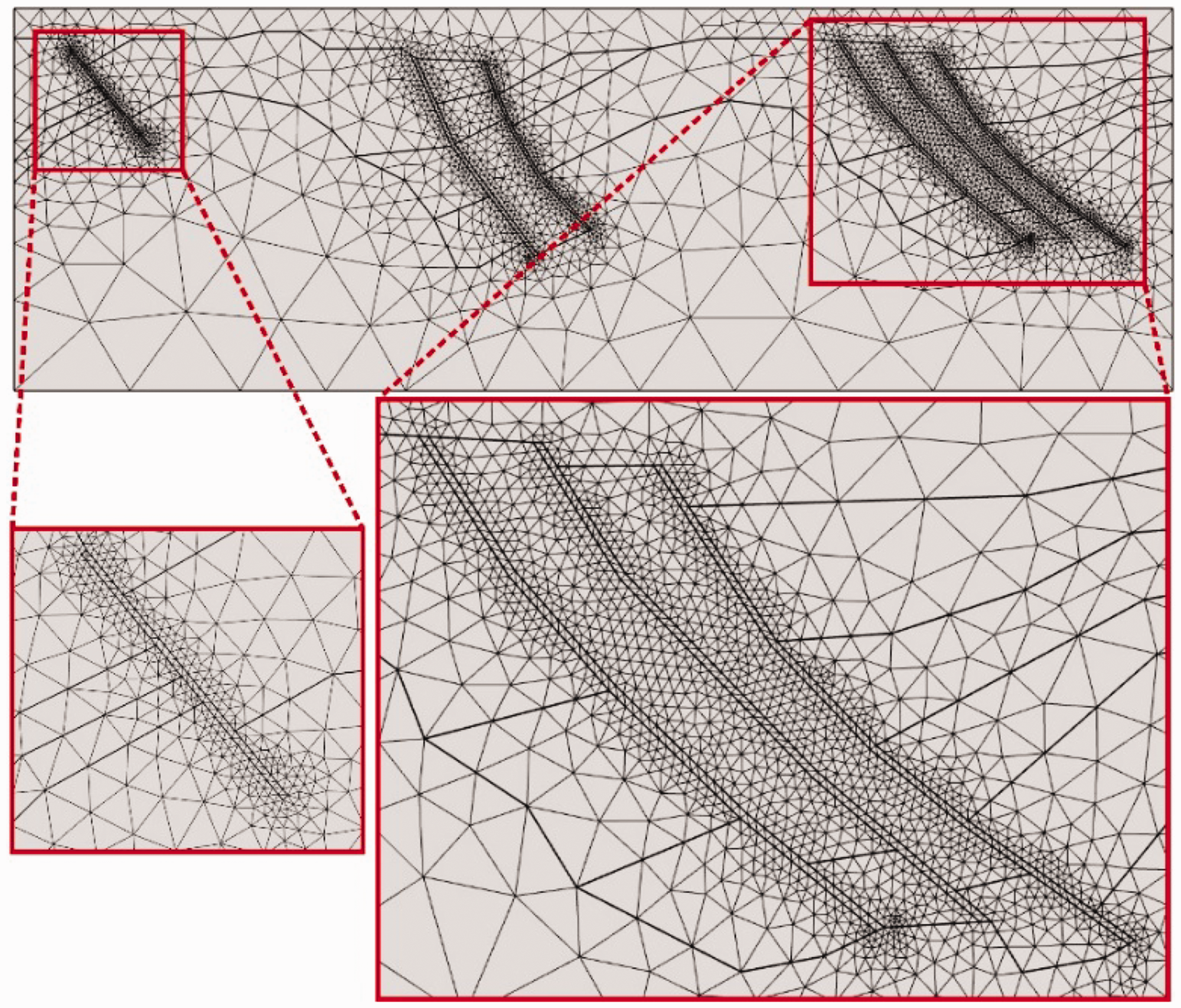
Grid division display diagram.
Results
Model calibration
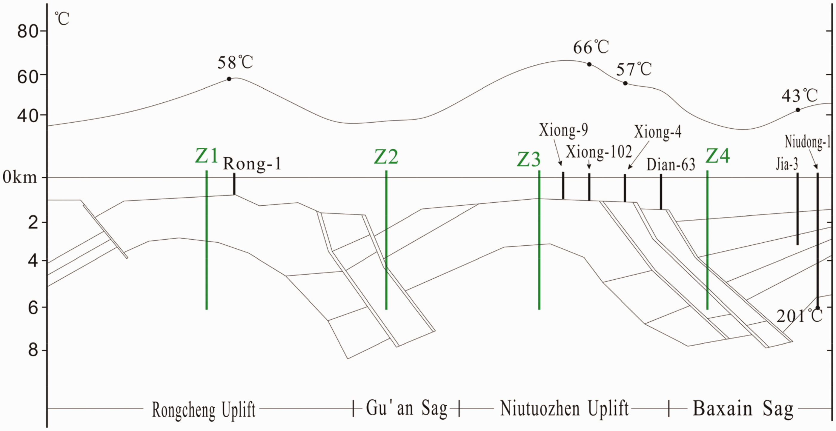
Zhou et al. (1989) studied the distribution of shallow temperature in the Xiong’an New Area and predicted the temperature of important sections based on borehole temperature measurement data. These results can be used as an important basis for our model identification. In general, the shallow temperatures of the Niutuozhen uplift and Rongcheng uplift are higher than those of the Gu’an sag and Baxian sag. The temperatures of wells Rong-1, Xiong-102, Xiong-4, and Jia-3 at 1000 m depth are 58°C, 66°C, 57°C, and 43°C, respectively (Figure 5). In 2011, researchers found a temperature of 201°C at a depth of 6027 m in the Huabei oilfield in the Baxian sag (Zhao et al., 2011). These five main temperature measurement points can control the horizontal and vertical directions and can calibrate the model results well.
Distribution of temperature at 1000 m depth along section I-Iʹ.
Figure 6 shows the temperature distribution at a depth of 1000 m obtained by simulation. The simulated temperature is consistent with the well logging results. The temperatures in the Niutuozhen and Rongcheng uplifts are relatively high, while those in the Gu’an and Baxian sags are relatively low. Based on fitting the simulated temperatures to those observed at the five control points, the simulated and well logging temperatures at Rong-1 and Xiong-4 are consistent, and the temperature differences between the simulated and well logging results at Xiong-102 and Jia-3 are less than 1°C. The simulated temperature in Niudong-1 at a depth of 6027 m is 203.1°C, resulting in an error of only 2.1°C. Taking measurement error into account, our model fitting effect is good.
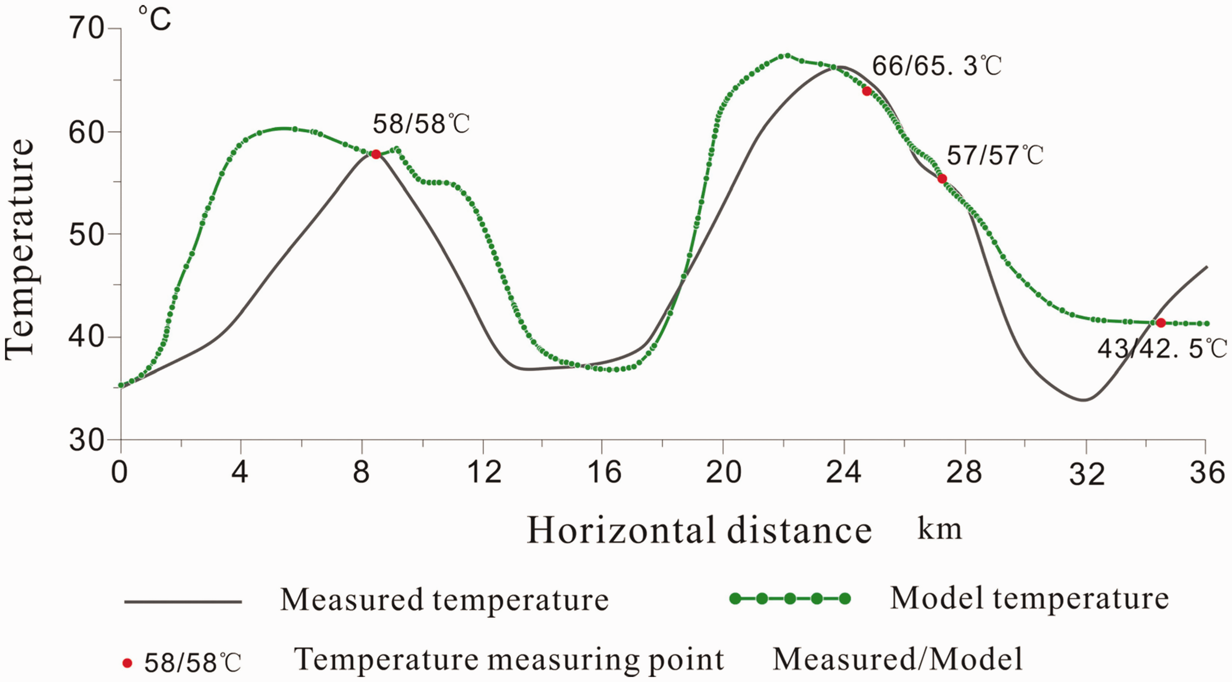
Comparison of simulated temperature and log temperature (1000 m depth along section I-Iʹ).
Temperature distribution
Figures 7, 8, and 9 show the temperature distributions at times of 100,000, 1 million, and 2 million years. In general, all the regional energy comes from basal heat conduction, and the temperature gradually increases over time.
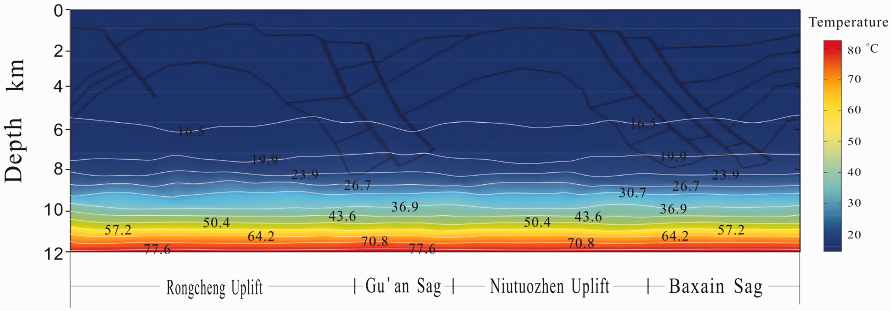
The distribution of temperature at 100,000 years.
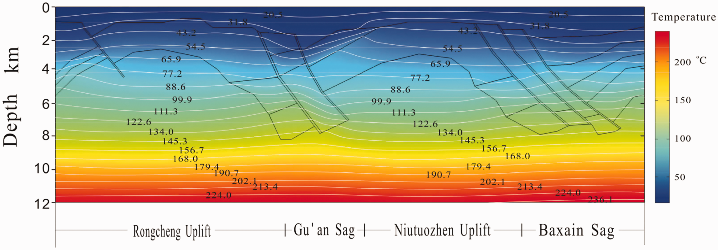
The distribution of temperature at 1,000,000 years.
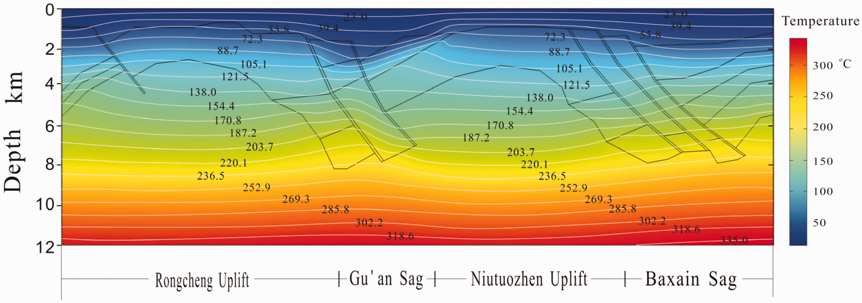
The distribution of temperature at 2,000,000 years (present day).
The influence of fractures is obvious. Due to the high thermal conductivity of fractures, the thermal conduction rate in the fracture channel is faster, and the heat reaches shallow formations more rapidly. Therefore, a geothermal contour bulge forms near the fracture (Figure 9). Figure 10 shows the temperature distribution at depths of 5 and 7 km and demonstrates that the temperature of the fracture is significantly higher than that of the surrounding strata. The temperatures at the Rongcheng fault at 5 and 7 km depth reach 170°C and 225°C, respectively, which are 10–20°C higher than the surrounding strata. The temperature of the Niudong fault at a depth of 7 km is close to that of the strata in the Baxian sag. This pattern occurs because the Niudong fault is close to the basement of the Baxian sag at a depth of 7 km, and the thermal conductivity of the basement is equal to that of the fault.
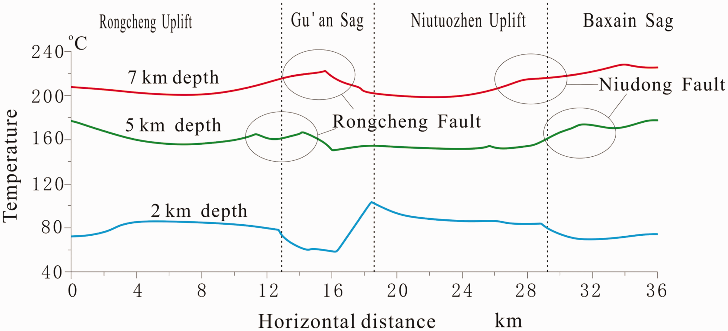
The distribution of temperature at 2, 5, and 7 km depth along transect I-Iʹ.
The temperature distribution at a depth of 2 km shows that the temperature in the shallow uplift region of the model is significantly higher than that in the sag region. The temperatures of the Rongcheng uplift and the Niutuozhen uplift can be up to 83°C, whereas the Gu’an sag and Baxian sag have the lowest temperatures, including the minimum Gu’an sag temperature of 58°C (Figure 10). This pattern occurs because the upper part of the sag features a very thick low thermal conductivity cap, with a slow heat conduction rate, which at the same time receives little heat energy. In contrast, the formations in the uplifts have high thermal conductivity and receive more heat energy. However, a comparison of temperatures at a depth of 5 km with those at a depth of 7 km reveals that the temperature in the deep uplift region is lower than that in the deep sag region, which is contrary to the pattern observed in the shallow region. The temperature in the deep part of the Baxian sag is 234°C (7 km), which is higher than those in the Rongcheng and Niutuozhen uplifts. This elevated temperature is because all formation heat comes from the bottom of the model, and the high thermal conductivity characteristic of the uplift regions is more conducive to the transport of heat to the shallow part. Under the input of set amount of heat, the temperature of the shallow part of the uplift region is relatively high, while that of the deep part is relatively low. Therefore, the shallow part of the uplift and the deep part of the sag are rich in geothermal resources and may represent target areas for future development.
Natural convection in the reservoir
The fluid density decreases with increasing temperature, and the density difference causes convection in the geothermal fluid. Based on the changes in the density of pure water, this study describes the flow driving force caused by the density difference using volume force (which is calculated with the following formula: 0.0005ρg△T).
The fluid streamline distribution in the heat reservoir is shown in Figure 11. The parts in red with larger widths represent high flow rates, while the blue thin lines represent low flow rates. As shown in the figure, under the influence of density differences, the deep high-temperature fluid moves towards shallow formations, but the flow velocity distribution is not uniform. Areas close to a fault, such as the Rongcheng fault and the Niudong fault, have high flow velocities, which can reach 3.5 × 10⁻⁵ m/s, and there is no obvious convection in the reservoir far from the fault. Moreover, areas with high flow velocity have the same strong convection effect and even form vortices of different sizes. This phenomenon occurs because the fracture acts as a heat upwelling channel, and the temperature differences and density differences near the fracture are large, resulting in a larger flow driving force and a higher flow velocity, thereby easily forming vortices. The vortices of different sizes contribute to making the temperature distribution in the reservoir consistent.
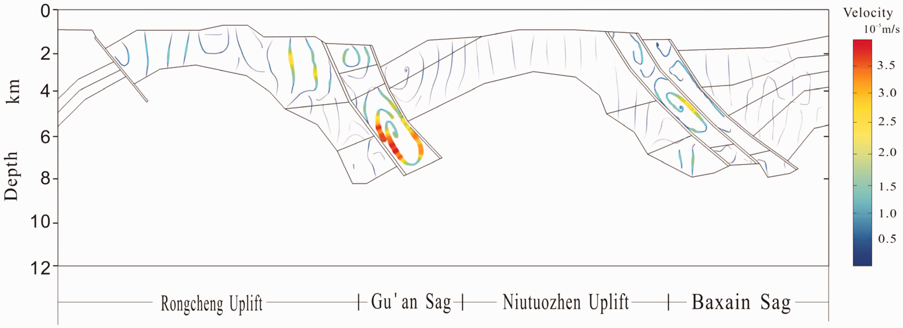
Density flow field distribution at the present day.
Heat flow
The near-surface geothermal heat flow value in the study area is calculated, and the results are shown in Figure 12. The heat flow in the uplifts is higher than that in the sag regions. The heat flow values in the Rongcheng uplift, Gu’an sag, Niutuozhen uplift, and Baxian sag are 64, 32, 75, and 37 mW/m2, respectively.
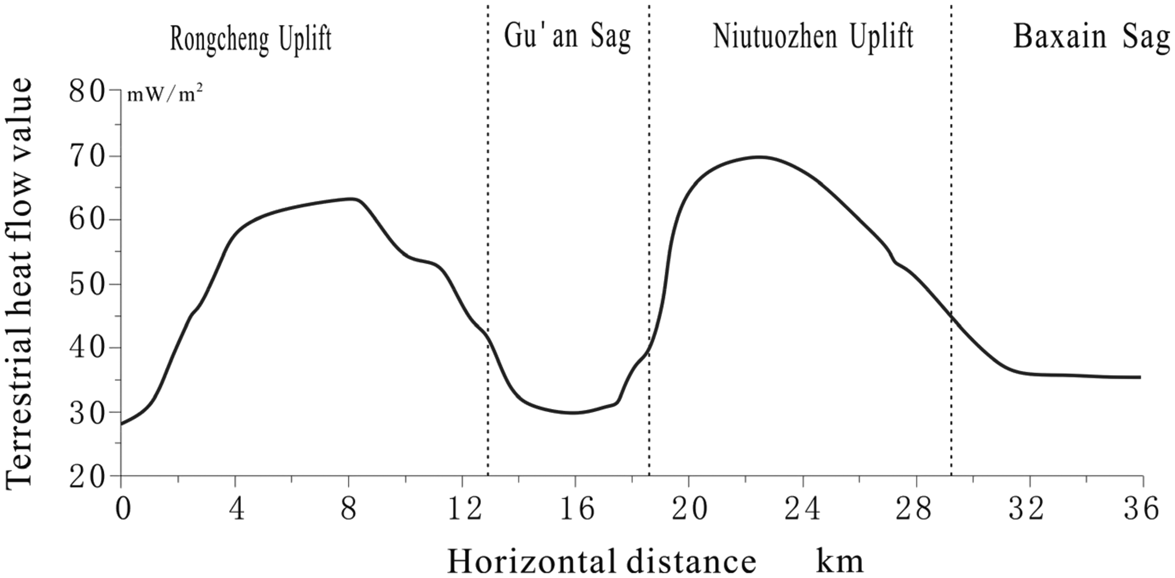
The near-surface terrestrial heat flow along transect I-Iʹ.
According to the research results of Li et al. (2014), the heat flow value in the Niutuozhen uplift is 66.3–113.8 mW/m2, and that in the Rongcheng uplift is 54.01–70.69 mW/m2. The calculated heat flow value is slightly smaller than these results because the data are all from geothermal wells without accounting for the influence of convection factors, and the results from Li are relatively high. This model weakens the influence of convection to some extent. Although the results are slightly low, they still have reference significance.
Well temperature prediction
The Xiong’an New Area is rich in geothermal resources. At present, the Rongcheng geothermal fields and Xiongxian geothermal fields have been identified. The thermal reservoirs are mainly in the Minghuazhen and Guantao formations and represent bedrock fissure karst reservoirs. These reservoirs primarily have development temperatures of less than 100°C and development depths of less than 2000 m. To further enhance the utilization of clean energy by exploiting geothermal energy, it is particularly important to develop deeper and higher temperature geothermal resources and establish efficient cascade development and utilization of geothermal energy. However, deep high-temperature geothermal drilling is difficult and costly, so accurate well location can play a positive role in saving on development and utilization costs in deep geothermal projects.
Based on the temperature distribution from the model, four boreholes were prepared for the Rongcheng uplift (Z1), Gu’an sag (Z2), Niutuozhen uplift (Z3), and Niudong fault (Z4). Considering the current drilling efficiency limit, the temperature distribution is calculated only to a depth of 6 km. See Figure 5 for each drilling location.
Figure 13 shows the temperatures and geothermal gradients of the four wells. There is a positive linear relationship between the well temperature and depth in the four boreholes. Z1 and Z3 have the highest temperature at depths less than 3.5 km, and Z2 has the lowest temperature because it contains the thickest sedimentary cover. Below a depth of 3.5 km, the temperature in well Z4 becomes the highest because well Z4 approaches the Niudong fault, and the high thermal conductivity of the fault transports considerable heat. From the perspective of the geothermal gradient distribution, Z1 and Z3 have the largest geothermal gradients at depths of less than 1 km, which is approximately 5°C/100 m. Below 1 km, the geothermal gradient stabilizes at 2–2.5°C/100 m. Z2 and Z4 are affected by faults, and the variation in the geothermal gradient is complex. In particular, the geothermal gradient of Z2 increases to 5.8°C/100 m at a depth of 2.5–3 km within the range of the influence of the Rongcheng fault. After passing through the fault, the geothermal gradient decreases. Below 5 km, the well approaches a fault again, and the geothermal gradient increases again.
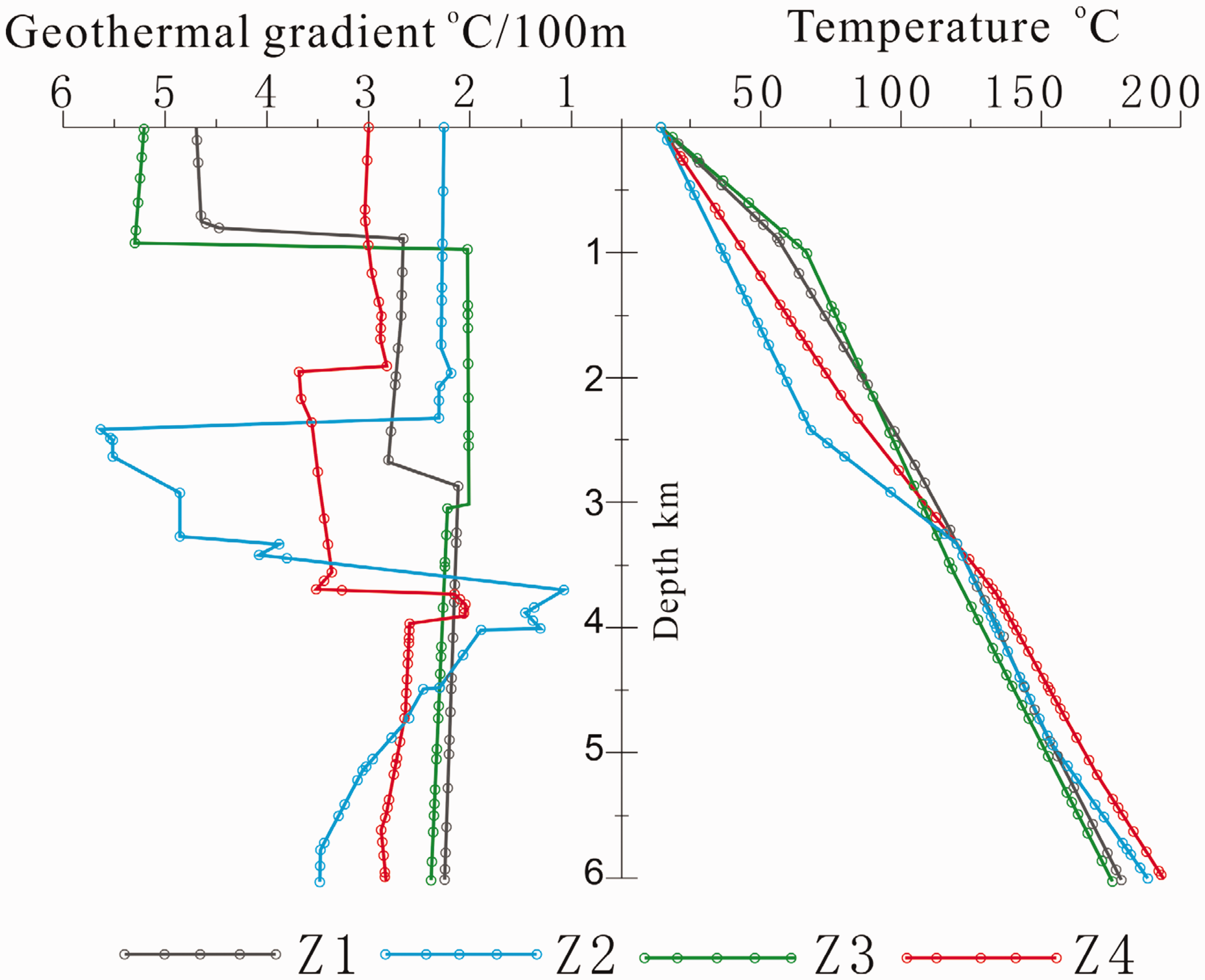
Distribution of borehole temperature and geothermal gradient.
In summary, the most efficient method to obtain high temperatures is to drill the hanging wall of the fracture and to not cross the fracture. The ideal situation is to expose the fracture upon completion of the drilling to obtain the maximum bottom hole temperature.
Conclusions
We established a 2D profile model of hydrothermal transport in the Xiong’an New Area and analyzed the distributions of the geothermal field, thermal flow value, well temperature, and geothermal gradient. The conclusions are as follows:
The geothermal accumulation in the Xiong’an New Area is a four-element model. Deep heat conduction is the source of heat. Deep faults provide an advantageous channel for the upwelling of heat, and the highest temperatures can be obtained near the faults. Geothermal resources are relatively abundant in the shallow parts of uplifts and the deep parts of sags. Intralayer convection occurs at different scales around the fault, which tends to make the temperature distribution in the heat reservoir consistent.
The terrestrial heat flow values we obtained in the Xiong’an New Area are 64 mW/m2 for the Rongcheng uplift and 75 mW/m2 for the Niutuozhen uplift.
The best drilling location is located in the hanging wall of the Niudong fault, and the designed well should terminate at the depth of the fault. In this study, the temperature of the Z4 well at 6 km depth reaches 200°C.
Footnotes
Declaration of conflicting interests
The author(s) declared no potential conflicts of interest with respect to the research, authorship, and/or publication of this article.
Funding
The author(s) disclosed receipt of the following financial support for the research, authorship, and/or publication of this article: This study was funded by National Key R&D Program of China (No. 2018YFC0604306), Special Funds for Basic Scientific Research of the Chinese Academy of Geological Sciences (SK201704, SK201501, YYWF20181101), National Natural Science Foundation of China (NO. 41602271), and a project of the China Geological Survey (DD20189112).