
Abstract
The Mozambique Basin, which occurs onshore and offshore in the central and southern parts of Mozambique, contains a thick sequence of volcanic and sedimentary rocks that range in age from the Jurassic to Cenozoic. This basin, along with the Rovuma basin to the north, has been the main target for hydrocarbon exploration; however, published data on hydrocarbon occurrences do not exist. In this context, the present study aims to contribute to the understanding of the nature of the organic matter of a sedimentary sequence intercepted by the Nemo-1X exploration well located in the offshore area of the Mozambique Basin. The well reached a depth of 4127 m, and 33 samples were collected from a depth of 2219–3676 m ranging in age from early to Late Cretaceous. In this study, petrographic and geochemical analytical methods were applied to assess the level of vitrinite reflectance and the organic matter type as well as the total organic carbon, total sulfur, and CaCO3 contents. The results show that the total organic carbon content ranges from 0.41 to 1.34 wt%, with the highest values determined in the samples from the Lower Domo Shale and Sena Formations, which may be related to the presence of the solid bitumens that occur in the carbonate fraction of those samples. The vitrinite random reflectances range from 0.65 to 0.86%Rrandom, suggesting that the organic matter in all of the samples is in the peak phase of the “oil generation window” (0.65–0.9%Rrandom). The organic matter is mainly composed of vitrinite and inertinite macerals, with a minor contribution of sporinite from the liptinite group, which is typical of kerogen type III. Although all of the samples have vitrinite reflectances corresponding to the oil window, the formation of liquid hydrocarbons is rather limited because the organic matter is dominated by gas-prone kerogen type III.
Keywords
Introduction
Mozambique, as an emerging African country is currently undertaking intense research and exploration of its natural resources, especially for hydrocarbons. Of the six major sedimentary basins in Mozambique (Figure 1) this activity is focused on two large basins: the Mozambique Basin in the central and southern part of the country and the Rovuma Basin in the north (Figure 1).
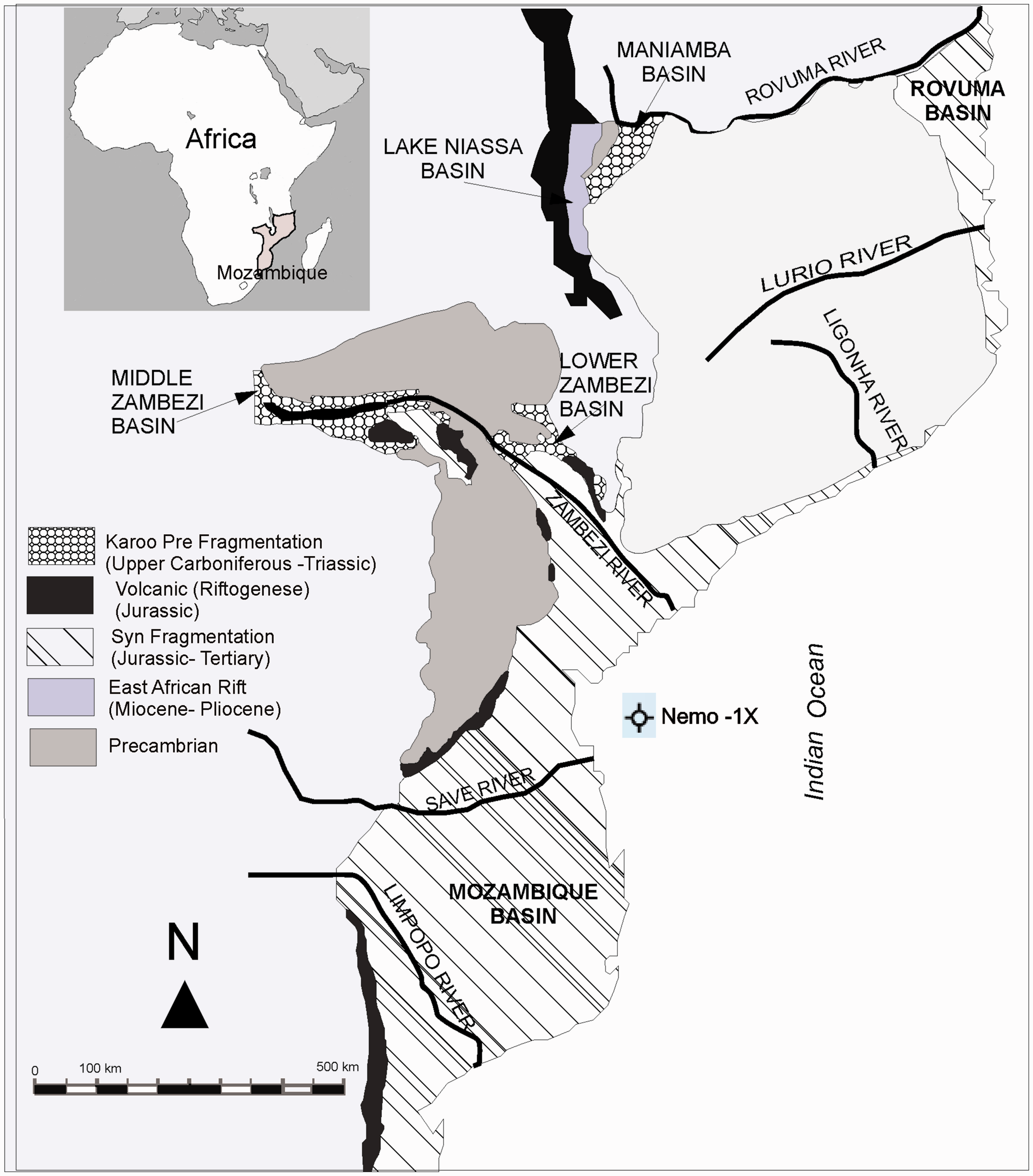
Map showing the six sedimentary basins of Mozambique (ECL, 2000) and the Nemo-1X well location investigated in the present study.
A general discussion on the hydrocarbon potential of the Mozambique Basin was published by Alan et al. (1991) and Iliffe et al. (1991). They used Royden’s model to determine the maturation and concluded that a source rock which reaches maturity for hydrocarbon generation likely lies somewhere within the Lower Cretaceous or Jurassic strata. The probability of such a source rock being present is enhanced by the high marine/terrigenous shale depositional setting envisaged for these strata.
The reservoirs may be present in Cretaceous rocks and regardless of the model used or the heat flow history configuration applied, the basin is expected to have mature hydrocarbon source rocks in the eastern part at depths of 3000–4000 m. The ideal situation of the relative timing of source deposition followed by faulting, seal deposition, and maturation of the source rocks seems to be the case in the South Mozambique Graben (Alan et al., 1991; Iliffe et al., 1991).
According to Michael (2016), the Mozambique Coastal Province contained only five gas accumulations exceeding the minimum size of 30 billion cubic feet of gas. This province is considered to be underexplored on the basis of its level of exploration activity. Using a geology-based assessment, the United States Geological Survey (USGS) estimated mean volumes of undiscovered, technically recoverable conventional oil and gas resources for the Mesozoic–Cenozoic Reservoirs Assessment Unit in the Mozambique Coastal Province. The mean volumes are estimated at 11.682 million barrels of oil, 182.349 billion cubic feet of gas, and 5.645 million barrels of natural gas liquids. The estimated mean size of the largest oil field that is expected to be discovered is 1.041 million barrels of oil and the estimated mean size of the expected largest gas field is 7.976 billion cubic feet of gas. For this assessment, a minimum undiscovered field size of 5 million barrels of oil equivalent was used by Michael (2016).
Published data on the hydrocarbon generation potential in the sedimentary basins of Mozambique are virtually nonexistent, and data are restricted to internal company reports (ECL, 2000; Lineback et al., 1986; Salman et al., 1990).
In the Mozambique Basin previous geochemical studies on the Nemo-1X well (Lineback et al., 1986) indicated the predominance of kerogen type III suggesting a continental depositional environment. This study also showed that based on vitrinite reflectances the thermal maturity of the organic matter in well Nemo-1X ranges from immature to the peak oil generation window.
However, relatively low hydrogen indexes as determined by Rock-Eval Pyrolysis suggest that hydrocarbon generation is restricted to gas generation potential in samples analyzed from the Cretaceous Lower Domo Shale Formation (Lineback et al., 1986).
The main objective of the present study is to add more information on the petrographic and geochemical characteristics of samples collected from the Nemo-1X well (Figure 1) and as such aid in the evaluation of the hydrocarbon generative potential of the Mozambique Basin.
The samples were analyzed using analytical methods of organic petrography and geochemistry. The role of organic petroleum in the exploration of conventional and unconventional hydrocarbon systems was recently reviewed by Hackley and Cardott (2016) and Suárez-Ruiz and Mendonça Filho (2017), including the delineation of organic maturity and the evaluation of organic facies.
In the present study, the petrographic analyses included vitrinite reflectance to assess the maturity of the studied sequence and to identify the petrographic composition, whereas the geochemical analyses included a determination of the total organic carbon (TOC), total sulfur (TS), and CaCO3 contents.
Geological setting
The Mozambique Basin occupies the central and southern parts of Mozambique, extending onto the continental shelf and slope (Figure 1). The sedimentary fill is composed of Upper Jurassic, Cretaceous, and Cenozoic rocks which overlie “Karoo” volcanics. It covers an area of approximately 500,000 km2, of which 275,000 km2 are onshore and 225,000 km2 offshore to the 2000 m isobaths (ECL, 2000). The basin forms a large asymmetric depression, inclined eastward and flanked by crystalline Pre-Cambrian basement or by the Karoo basalts (Salman et al., 1990).
The peculiarities of the tectonic structure are determined by the relationship between the several phases of structural development:
the Mozambique Basin is part of the East African continental margin system, whose formation can be traced from the Late Jurassic/Early Cretaceous; the structures of the basin overlie the more ancient structural elements of the Gondwanaland intracratonic trough and the Karoo grabens; the pericontinental depression overlies the rift structures of the early riftogenic stage (Late Jurassic/Early Cretaceous); the basin is located at the southern end of the East African Rift, which is dated as neo-riftogenic stage (Late Cretaceous–Cenozoic) (Salman et al., 1990).
The following structural stages have been identified in the tectonic structure of the Mozambique Basin, reflecting the main stages in the geological history of the basin:
pre-Cambrian crystalline basement; Gondwana structural stage (Karoo) and post-Gondwana stage (Upper Jurassic Cenozoic) (Salman et al., 1990). The stratigraphic sequence of the basin (Figure 2) is comprised of Cenozoic, Cretaceous, and Upper Jurassic sedimentary rocks, as well as igneous rocks of the Karoo (Salman and Abdula, 1995).
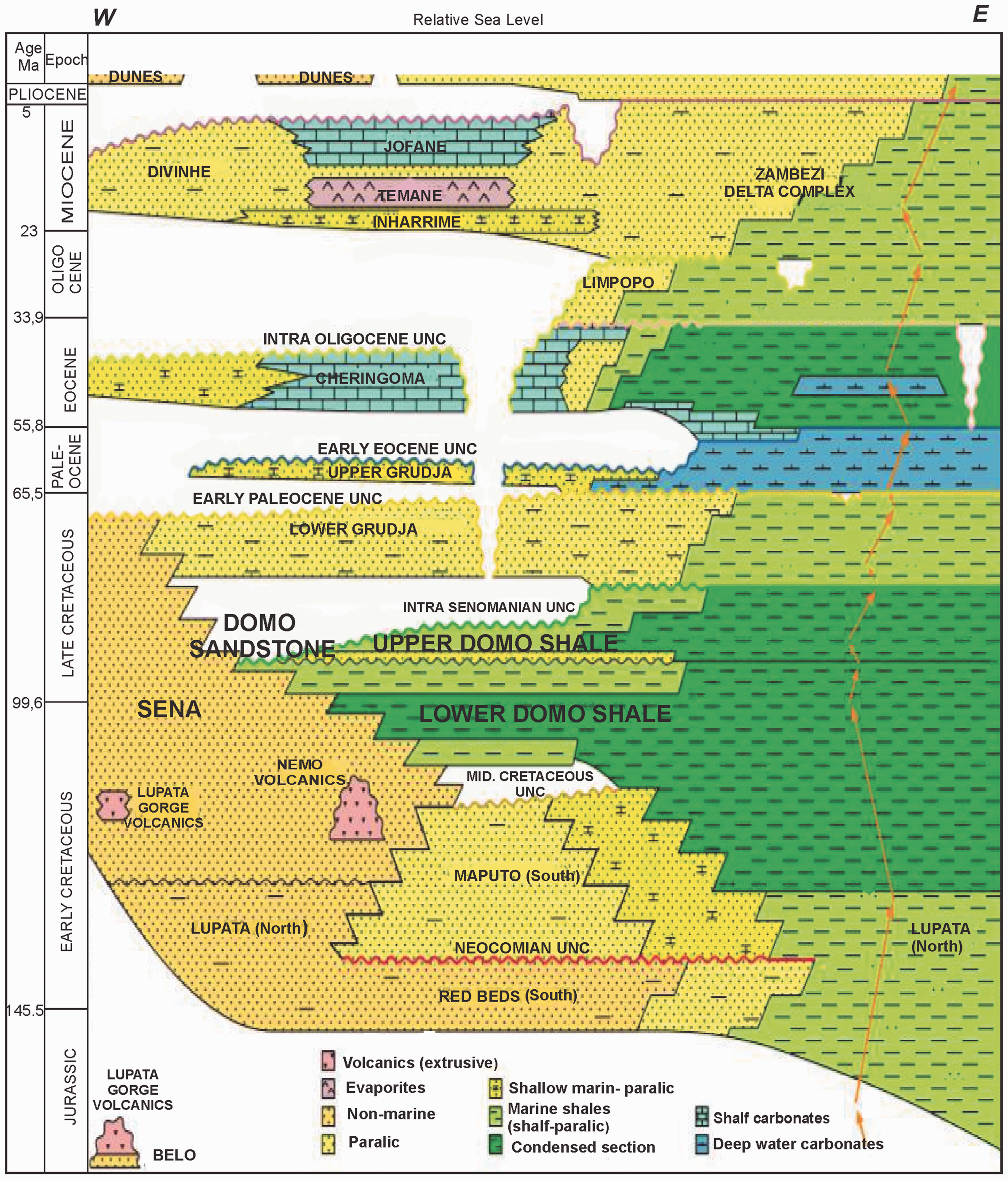
General stratigraphy of the Jurassic to Tertiary strata of the Mozambique Basin (ECL, 2000).
Stratigraphically (from bottom to top), the Mozambique Basin has the following geological formations (Figure 2): Red Beds, Lupata, Maputo, Sena, Lower Domo Shale, Domo Sand, Upper Domo Shale, Lower Grudja, Upper Grudja, Cheringoma, Zambezi Deltaic Complex, Inharrime, Temane, Jofane (ECL, 2000). Lithologies and depositional environments of these formations are discussed briefly below based on studies by ECL (2000), Salman and Abdula (1995), and Salman et al. (1990).
The basal Red Beds Formation (Figure 2) represents the initial flooding of the shelf in the Late Jurassic and subsequent deposition of the first true drift deposits. The top of this sequence is represented by the “brown” horizon designated as the “Mid-Cretaceous Unconformity” which in the Zambezi Depression marks the transition from the Lupata Formation to the Lower Domo Shale (ECL, 2000).
The Lupata Formation (Figure 2) is developed in the NW part of the basin within the limits of the Zambezi Graben. This section is an eroded basalt surface and it comprises multicolored conglomerates and sandstones with large gneiss and Karoo rock fragments. These sediments are interbedded with rhyolite lavas.
The total thickness of this sequence is about 150–200 m, the age of the Lupata Formation defined by K/Ar method ranges from 166 to 106 MA. It was thus deposited between the end of the Middle Jurassic and the Early Cretaceous (Salman et al., 1990).
Maputo Formation (Figure 2) is distributed in the southern and central areas of the Mozambique Basin and occurs as a layer of Glauconitic-quartzose sandstone and arenaceous limestone, interbedded with argillites. Sandstone of the Maputo Formation is deposited on eroded Stromber Basalts or on the Red Beds. The most recent dating of the Maputo Formation suggests that it is of Neocomian stage (Salman et al., 1990).
The Sena Formation (Figure 2) is predominated by arkosic sandstone, pebble, and conglomerate lithologies, representing continental and deltaic sediments.
The Lower Domo Shale Formation (Figure 2) is a thick sequence consisting of dark-colored shale with occasional sandstone interbeds. It is the marine equivalent to the Sena Formation and can be correlated across a lateral facies change.
The sediments of Lower Domo Shale Formation provide a regional cap rock for the reservoirs, and in addition, the thick shale sequence is regarded as the main source for hydrocarbon generation within the Mozambique Basin, with source rock properties improving toward the east (Salman et al., 1990).
The Domo Sand Formation (Figure 2) comprises interbedded quartzose and glauconitic-quartzose sandstone with shale. The sands were deposited within a narrow near-shore zone in a shallow-water shelf environment, which gradually transgressed in a westerly direction. In the east a deeper water environment existed, and in this area the sandstones are thinner and the formation becomes progressively more shaley eastwards (Salman et al., 1990).
The Upper Domo Shale Formation (Figure 2) is characterized by the occurrence of continental clay sands and sandstone. The distribution of the Upper Domo sands and facies relationship within this interval is typical of a transgressive marine sequence. The most favorable conditions for forming sandstones with good reservoir properties are related to the shallow-water shelf zone developed in the southwestern and southern areas of the Zambezi Block (Salman et al., 1990).
The Lower Grudja Fm. (Figure 2) consists of dark gray shale interbedded with beds of glauconitic sandstones originally deposited over the whole basin. This sequence was formed in a shallow-water shelf environment (Salman et al., 1990).
The Upper Grudja Fm. (Figure 2) is a sequence of glauconitic sands, clays, and marls interlayered with bands of limestone (Salman et al., 1990). The Upper Grudja Formation was deposited at a time of transgression and highstand and decreasing siliciclastic input in the Early Paleocene. The total thickness of the formation is 300–400 m (Salman and Abdula, 1995). The formation was deposited in an entirely subaqueous, low-energy offshore marine environment which appears to have occurred over a large area (ECL, 2000).
The Cheringoma Formation (Figure 2) (Middle–Upper Eocene) comprised of limestone with bands of clays and calcareous sandstones. The thickness of the formation is 250 m. Limestone is widespread in the western areas of the Mozambique Basin and were deposited on an unconformity (Salman et al., 1990).
The Zambezi Deltaic Complex (Figure 2) is the largest Cenozoic deltaic complex along the East African coast. The complex consists of Oligocene to recent sediments and exhibits a total thickness of 4000 m. The strata of the Zambezi Deltaic Complex comprise an intercalation of conglomerates, sandstone, and shale with typical deltaic bedding and numerous interfacies hiatuses and ancient erosional canyons (Salman et al., 1990).
Strata of the Inharrime Formation (Figure 2) comprise a sequence of red dolomites, red clays, and sandstones with bands of anhydrite. The Formation thickness is 100–300 m. These sediments were deposited in a restricted lagoonal environment (Salman et al., 1990).
Strata of the Temane Formation (Figure 2) consist of interbedded anhydrite, red clays, and sandstones, which were formed within the central part of a brackish-water lagoon. The Temane anhydrites occupy the central part of the basin and are similar in age to Inharrime beds. The thickness of the formation is up to 110 m.
Strata of the Jofane Formation (Figure 2) occur primarily as marine carbonate facies such as limestone, calcarenite, and arenaceous limestone, attaining a thickness of up to 200 m (Salman et al., 1990).
Tertiary sediments are represented both by shallow-water shelf and deeper-water continental slope deposition. Within the shallow-water shelf area the tertiary sediments are stratigraphically and lithologically subdivided in the following formations: Upper Grudja, Cheringoma, Inharrime, Temane, and Jofane.
Well location, sampling, sample preparation, and analytical methods
Well location and sampling
The Nemo-1X well is located offshore central Mozambique (Figure 1) with a depth of 4127 m. The well intercepted (from top to bottom) the following formations (Figure 2), which ranged in age from the Eocene to Early Cretaceous: the Cheringoma and Deltaic complex, Upper Grudja, Lower Grudja, Upper Domo Shale, Domo Sand, Lower Domo Shale, Sena, and volcanic agglomerates.
The samples were collected by the first author at the National Hydrocarbon Company Mozambique (ENH) in form of dry and nonwashed cuttings.
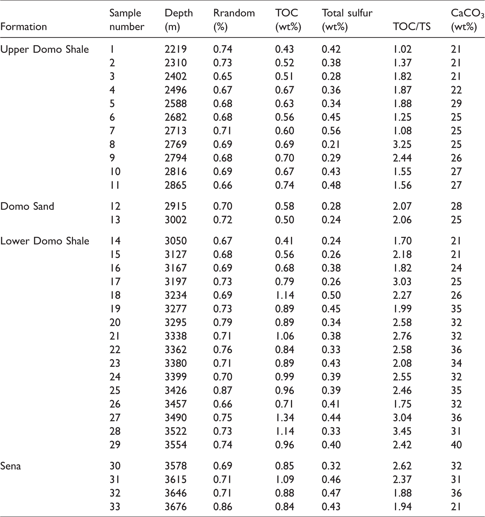
A total of 33 samples (cuttings) were collected from four stratigraphic intervals (Table 1), the Upper Domo Shale, Domo Sand, Lower Domo Shale, and Sena Formations (Table 1), and were submitted to petrographic and geochemical analyses.
Sample identification, vitrinite random reflectances (%Rrandom), total organic carbon (TOC) (wt%), total sulfur (TS) (wt%), TOC/TS ratios, and CaCO3(%) contents of the studied samples.
Sample preparation
The sample preparation included cleaning the cuttings with dichloromethane to remove impurities from drilling, as they were collected dry and not washed prior to preparation for geochemical analysis. Grain size for chemical analyses was <250 µm, whereas grain size for petrographic analysis was approximately 2 mm.
Geochemical analyses (TOC, TS, and CaCO3)
The samples were pulverized (<80 mesh) and 1 g of the pulverized sample was submitted to the TOC analysis. Prior to the analyses the samples were subjected to chemical treatment to eliminate the inorganic carbonate fraction according to the following methodology:
Step 1: About 0.26 g of the sample previously pulverized was weighed into a filter porcelain crucible (of known mass). After weighing, the samples were acidified with hydrochloric acid (HCl) during 24 h to remove the carbonates present; Step 2: The samples were washed with hot distilled water for 1 h to remove the chlorides. The samples were then washed with distilled water at room temperature until the pH was near 6, and finally, the excess water was drained. Step 3: Samples were placed in an oven at 65°C for approximately 3 h for drying. After cooling, the crucibles were weighed again.
After the acidification process, for TOC and TS determinations, all the samples were analyzed using a LECO SC144 analyzer. The equipment was calibrated using standard samples before and after the analyses. A muffle furnace that reaches temperatures of 1350°C was used for the analyses, leading to complete combustion of the sample. The equipment records the concentrations in CO2 and SO2 gases, the result being expressed as a percentage of mass.
The carbonate (CaCO3) content was determined by the following equation

The IR was calculated using

Petrographic analyses
Polished blocks of whole rock samples for petrographic observations were prepared according to American Society for Testing and Materials (ASTM) D2797 (2011) standard.
The mean random reflectance (%Rrandom) was measured on vitrinite and on solid bitumen according to ASTM D2797/D2797M11 (2011) and ASTM D7708-14 (2014) using a LEICA DM 4000M microscope equipped with a 50X oil immersion objective. A Discus-Fossil software was used to determine the vitrinite reflectances. The microscope was calibrated using a YAG standard (0.903%Rrandom) and an optical black (zero) glass.
The identification and characterization of the organic matter were made according to the internationally proposed TSOP-ICCP Dispersed Organic Matter Classification (Stasiuk et al., 2002), using both reflected white light and incident blue light (fluorescence) illumination. The solid bitumens were classified according to Jacob (1989).
Results
The results of the geochemical and petrographic analyses of the samples are listed in Table 1.
TOC, TS, and CaCO3 contents
TOC content
The TOC values in the samples from well Nemox-1X range from 0.41 to 1.34 wt% (Table 1), gradually increasing with depth, most likely related to slightly higher accumulation and preservation rates in samples taken from greater depths.
The Upper Domo Shale and Domo Sand formations have TOC contents between 0.43 and 0.74 wt% (Table 1, Figure 3), with the majority of samples having contents between 0.5 and 1.0 wt%. According to Peters and Cassa (1994) these samples have a fair hydrocarbon generation potential.
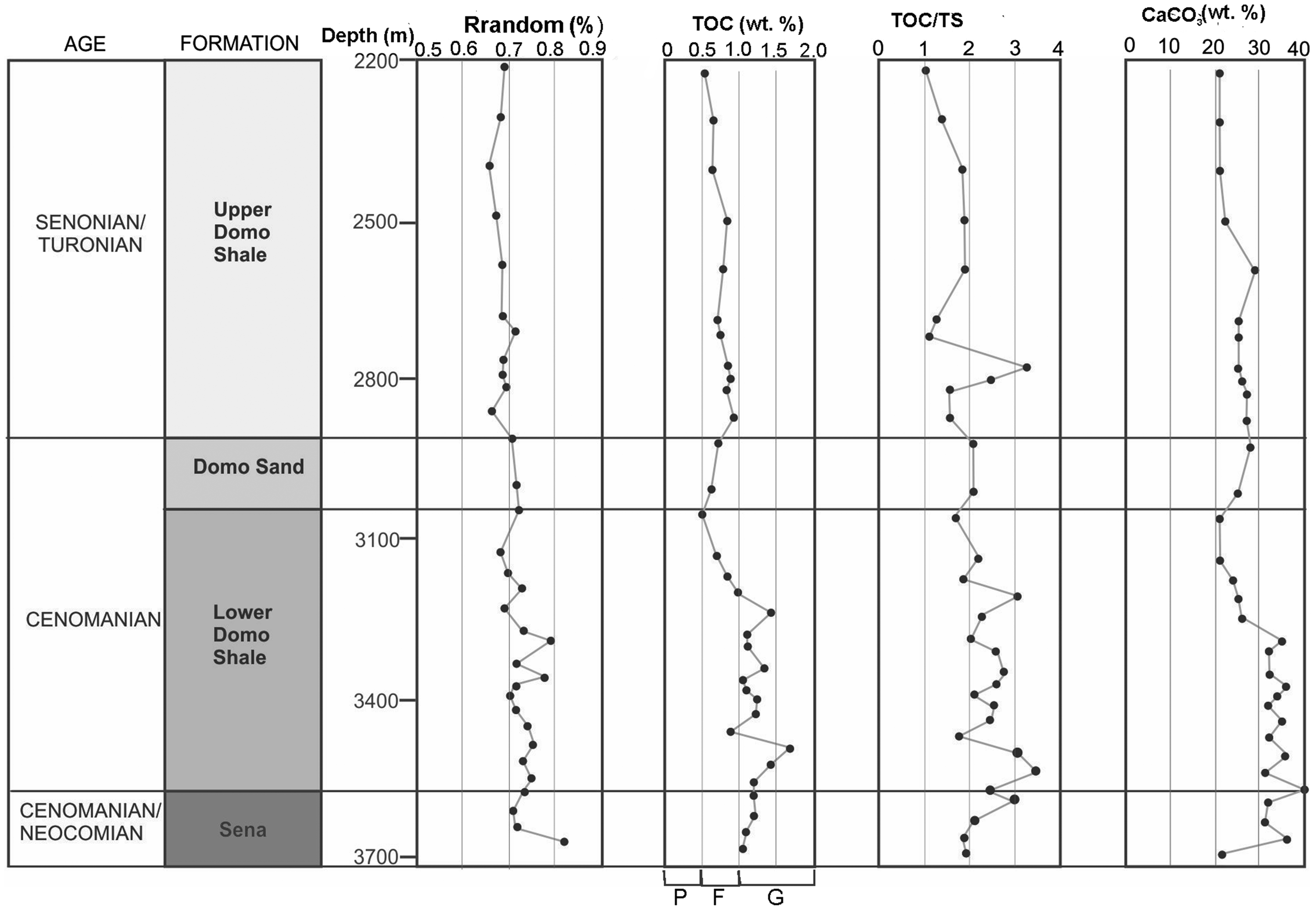
Depth variations of vitrinite reflectances, TOC, and CaCO3 contents and the TOC/TS ratios in the Nemo-1X well. Hydrocarbon generation potential based on TOC contents: P (poor) = TOC< 0.5 wt%; F(fair)=TOC 0.5–1.0 wt%; G (good) =TOC 1.0–2.0 wt%, from Peters and Cassa (1994). TOC: total organic carbon; TS: total sulfur.
The highest values were found in the samples from the Lower Domo Shale and Sena Formations, where most of the samples have TOC values between 0.5 and 1.5 wt% (Table 1, Figure 3). According to Peters and Cassa (1994) this group of samples has a fair-to-good hydrocarbon generation potential. Considering these criteria, the samples with the best hydrocarbon generation potential are from the Lower Domo Shale and Sena Formations, confirming that as suggested by Salman et al. (1990), the strata of the Lower Domo Shale Formation are the main source rocks for hydrocarbon generation within the Mozambique Basin.
TS content
The TS content is considered to give an indication of the physicochemical conditions (oxidation versus reduction) of the depositional environment (Tissot and Welte, 1984).
Microscopic analyses showed the abundance of pyrite in the samples and it is suggested that the majority of the sulfur determined by chemical analysis comes from source.
The TS contents determined for the Nemo-1X well samples were relatively low and did not exceed 0.56 wt% (Table 1).
TOC/TS ratios
The majority of samples analyzed from the Upper Domo Shale, Domo Sand, Lower Domo Shale, and Sena Formations have TOC/TS ratios less than 3 (Table 1), which according to studies by Berner (1995) and Borrego et al. (1998) indicate a reducing depositional environment.
CaCO3 content
The sequence analyzed is essentially siliciclastic with relatively high carbonate contents in certain intervals. The CaCO3 content is minor in the Upper Domo Shale and Domo Sand formations, with values ranging between 20 and 30%, whereas in the Lower Domo Shale and Sena Formations the CaCO3 contents increase gradually with depth reaching up to 40% (Figure 3). The increase of the CaCO3 content in these formations is associated with the presence of solid bitumen, which may suggest a preferential precipitation of the bitumen within the carbonate fraction.
Petrographic composition
According to the petrographic analysis, the dispersed organic matter identified in the samples is essentially comprised of macerals of the vitrinite and inertinite groups, with particle sizes varying between 5 and 50 µm (Figure 4(a) to (c)), corresponding to gelified preserved tissues from higher plants, occasionally preserving the botanical structure. Macerals of the liptinite group, identified using blue light excitation, are very rarely observed (Figure 4(d)) and were identified as sporinite.
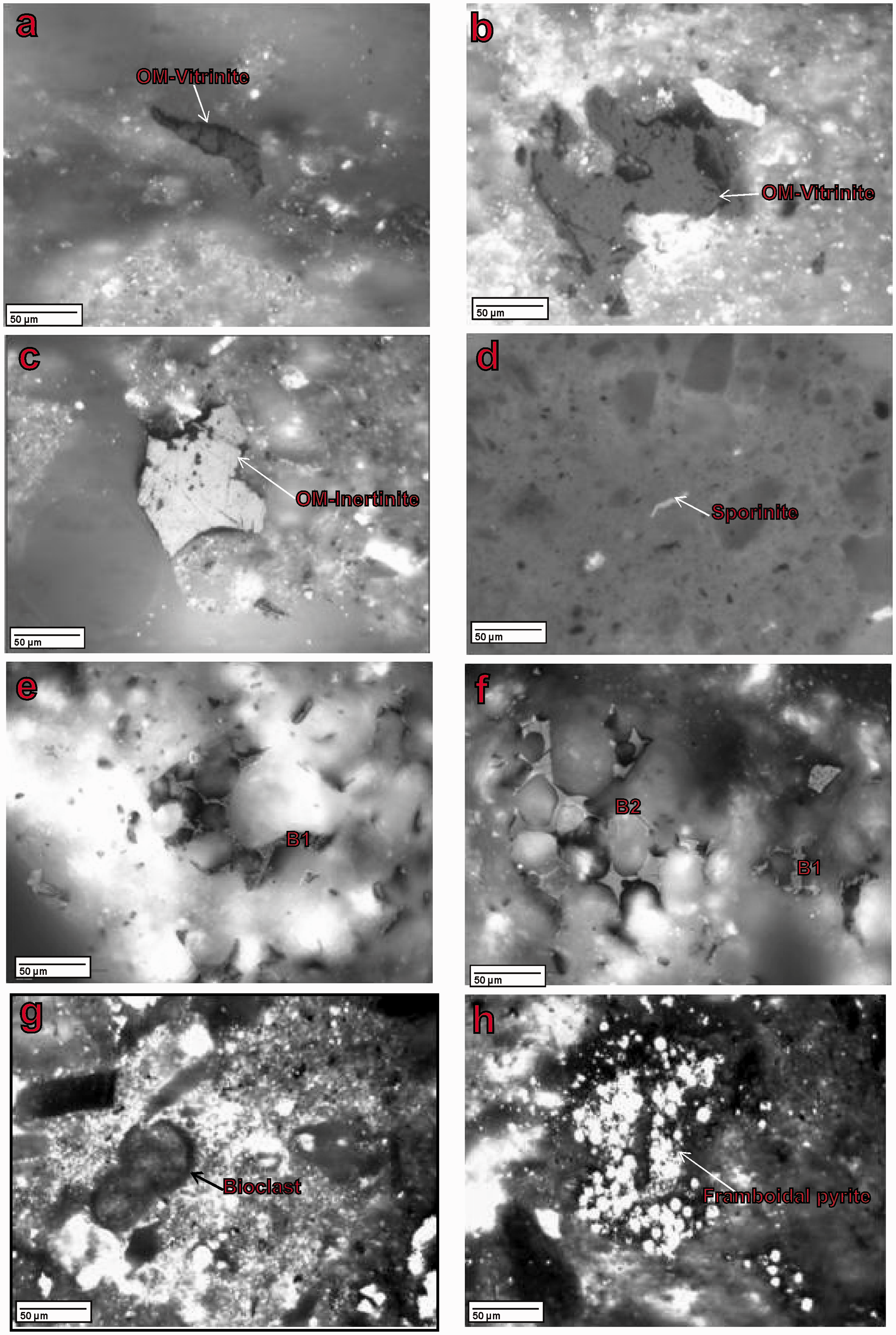
Photomicrographs of organic particles observed in samples from the Nemo-1X well: (a) Vitrinite fragments associated with mineral matter, sample 16, depth 3167 m, Lower Domo Shale Formation, micrograph taken in reflected white light illumination; (b) vitrinite fragments associated with mineral matter,sample 19, depth 3277 m, Lower Domo Shale Formation, micrograph taken in reflected white light illumination; (c) inertinite fragments associated with mineral matter, sample 31, depth 3615 m, Sena Formation, micrograph taken in reflected white light illumination; (d) sporinite, sample 20, depth 3295 m, Lower Domo Shale Formation, micrograph taken under reflected blue light excitation; (e) and (f) solid bitumen (B1—family 1 and B2—family 2), sample 27, depth 3490 m, Lower Domo Shale Formation, micrograph taken in reflected white light illumination; (g) bioclast fragments associated with mineral matter, sample 24, depth 3399 m, Lower Domo Shale Formation, micrograph taken in reflected white light illumination; (h) framboidal syngenetic pyrite associated with mineral matter, sample 17, depth 3197 m, Lower Domo Shale Formation, micrograph taken in reflected white light illumination.
In some samples of the Lower Domo Shale and Sena Formations, two families of solid bitumen (Figure 4(e) and (f)) denominated B1 family and B2 family were observed in the intercrystalline void spaces of the mineral matter essentially associated with carbonates. Their shapes varied according to the pore shapes where they occurred and exhibited optically isotropic homogeneous properties. The B1 family had reflectances between 1.5 and 2.0%Rrandom, and the other family (B2) had reflectances between 2.1 and 2.6%Rrandom (Figure 5). According to Jacob (1989), the bitumen families were classified as epi-impsonite (family B1) and meso-impsonite (family B2), respectively.
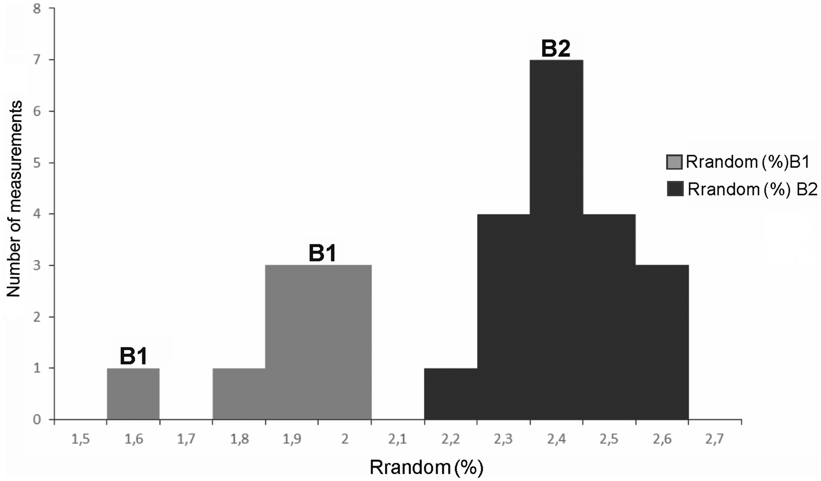
Histogram of the solid bitumen reflectances (B1 and B2) of sample 19, depth 3277 m.
Numerous occurrences of dispersed, low maturity migrabitumen such as albertite, gilsonite, and wurtzilite may indicate the occurrence of petroleum, whereas high maturity dispersed migrabitumen such as impsonite, usually imply that no petroleum can be expected (Jacob, 1989). If suitable trap structures are present, natural gas or condensate can be associated with the occurrences of the high maturity migrabitumen.
Throughout the sequence, some bioclasts (Figure 4(g)) corresponding to fragments of fossil shells and significant quantities of framboidal syngenetic pyrite (Figure 4(h)) were also observed.
In general, the organic matter identified in the Nemo-1X well represented kerogen type III, as indicated by the predominance of vitrinite and inertinite macerals.
Vitrinite macerals originate from land plants and mature along the type III kerogen pathway (Peters and Cassa, 1994). These macerals are considered to be derived from a terrestrial source and are gas-prone constituents. In the Mozambique Basin the organic matter derived from a terrestrial source was deposited in a suboxic environment suitable for its preservation, which is in accordance with the presence of framboidal syngenetic pyrite in all of the analyzed samples. The presence of solid bitumen suggested that some hydrocarbon migration occurred (Jacob, 1989).
Vitrinite random reflectance (%Rrandom)
The vitrinite random reflectances determined from the Nemo-1X well samples ranged from 0.65 to 0.86%Rrandom (Table 1), which places all of the samples within the peak oil window (0.65–0.90%Rrandom) as defined by Peters and Cassa (1994). The vitrinite reflectances show a slight increasing trend with depth (Figure 3), and most values in the upper part of the section (Upper Domo Shale) are <0.70%Rrandom, whereas most samples from the lower part of the section (Lower Domo Shale) have vitrinite reflectances higher than 0.70%Rrandom (Figure 3).
Hydrocarbon potential
The samples analyzed from the Nemo-1X well are characterized by relatively low TOC levels, with kerogen type III (gas prone) predominant. Despite the fact that the organic matter is in the peak maturity stage for liquid hydrocarbon generation, the relatively low TOC contents and the predominance of kerogen type III are not likely to produce a large volume of liquid hydrocarbons. There may be, however, a potential for the generation of gas at higher maturity levels.
Conclusions
The TOC contents of the samples range from poor to good (0.41–1.34 wt%) and show a tendency to increase with depth; the highest values occurring in the Lower Domo Shale Formation. These higher levels appear to be associated with solid bitumen that occurs in the carbonate fractions of these samples.
The analyzed sequence is essentially siliciclastic, although a large part of the Lower Domo Shale and Sena Formation samples had a carbonate fraction (CaCO3) that reached 40%. The organic matter was preserved in an essentially reducing environment that was favorable for its preservation, which was also documented by the presence of pyrite in the entire sequence.
According to the petrographic analyses, the organic matter is dominated by vitrinite and inertinite macerals, with a minor contribution of liptinite (sporinite), which is typical for a terrestrial origin kerogen type III. The solid bitumen identified in samples from the Lower Domo Shale Formation had reflectances ranging from 1.5 to 2.6%Rrandom, which based on Jacob (1989) were classified as epi-impsonite and meso-impsonite.
The vitrinite random reflectances range from 0.65 to 0.86%Rrandom, suggesting that the organic matter for the analyzed depth interval (2219–3676 m) is in the peak hydrocarbon generation stage (catagenesis).
However, hydrocarbon generation potential of the organic matter is limited by the relatively low TOC contents and the predominance of kerogen type III, although there may be potential for gas generation at higher maturity levels.
Footnotes
Acknowledgments
The first author would like to thank the European Commission for the awarded scholarship (Project Mundus ACP2), which allowed the opportunity to attend the Master in Geology Program in the Faculty of Sciences of the University of Porto (FCUP). Empresa Nacional de Hidrocarbonetos (ENH) provided the well samples and all of the company’s data and documentation and provided necessary collaboration during the sampling. This work was performed within the cooperation protocol established between the ENH and the FCUP to perform a Master’s Dissertation for Mozambican students. The authors like to thank Drs. J. Esterle, University of Queensland and N. Wagner, University of Johannesburg for helpful comments on the manuscript resulting in a significant improvement.
Declaration of conflicting interests
The author(s) declared no potential conflicts of interest with respect to the research, authorship, and/or publication of this article.
Funding
The author(s) received no financial support for the research, authorship, and/or publication of this article.