
Abstract
The Zhanhua Depression is a hydrocarbon-rich, fault-generated depression in Bohai Bay Basin, eastern China. Gubei slope zone, located in eastern Zhanhua Depression, is an important oil production region. Drilling cores, logging data, and 3D seismic data were used to identify several depositional system infilling the slope zone, including braided-delta, sublacustrine fans, and deep/semi-deep lake fine-grained deposits and turbidite, all of which are associated with a lacustrine succession belonging to the 3rd member of Shahejie Formation (Es3). Sedimentary rock of Es3 are composed of mudstone, silty mudstone, fine sandstone, coarse sandstones, and conglomeratic sandstones with various structures including massive bedding, parallel bedding, scour-fill structures, graded bedding, and deformed structures. Sandstone distributed in braided-delta front subfacies, lacustrine fans and some turbidite are favorable reservoir facies. Fault system was an important hydrocarbon migration pathway and sometimes a sealing geologic unit, which played an important role in the formation of commercial oil reservoirs in Gubei slope zone. The commercial oil reservoir is dominantly distributed in ridge-like structures in Gubei slope zone, which give an inspiration that ridge-like structure was probably a very favorable area for hydrocarbon exploration in continental basin slope zone.
Keywords
Introduction
Bohai Bay Basin, a lacustrine rift basin formed during the Mesozoic and Cenozoic eras, containing some of the most prolific hydrocarbon source rocks and reservoirs, is located in the eastern part of China. Large volumes of oil and gas were generated from the original deposition of organic-rich mudstone, and subsequently contained in effective reservoirs within the basin (Li et al., 2003). Effective reservoirs in Bohai Bay Basin include sandstones deposited in braided and fan deltas, sublacustrine fans, beach bars, and turbidites (Chen et al., 2009; Feng et al., 2013). Braided-deltas are sand- to gravel-rich deltas that form where a braided fluvial system (including humid-region and glacial outwash fans dominated by fluvial process) prograde into a standing body of water (McPherson et al., 1987). Sublacustrine fan typically consists of poorly sorted and sub-rounded sandy conglomerate that is formed at the canyon mouth of a lake (Dasgupta, 2002; Huo, 1990). A turbidite is a kind of sediment deposited from a turbidity current, which is the current of sediment-charged water that moves under the force of gravity (Shanmugam, 2000). Sublacustrine fans and turbidite usually deposit in deep water. These deposits always deposit interbedded with organic-rich shale, i.e. hydrocarbon source rocks, and hence they often are an important type of lithologic hydrocarbon reservoirs with excellent exploration results throughout the world (Mayall et al., 2006; Shanmugam, 2000; Zhang, 2004). Braided-deltas, composed mainly of sandstone and conglomerate with higher porosity and permeability, are usually located on effective hydrocarbon migration pathway and are a suitable place for hydrocarbon accumulation especially in lacustrine basins (Dong et al., 2011; Huang et al., 2012). These deposits are somehow affected by syndepositional faults and are well developed in syndepositional fault slope zone (Feng et al., 2013; Lin et al., 2000).
The main oil-bearing sequence in Gubei slope zone is Paleogene Shahejie Formation (Es) which is further divided into four members, Es1 to Es4 from top to bottom; Es1, Es3, and Es4 members contain commercial oil. The Gubei slope zone is about 200 km2, and the prototyped reserve of the oil in Es3 and Es4 is 713 m tons (Yang et al., 2008). Although the types of depositional system and their distribution in the Gubei slope zone play an important role in controlling reservoir quality and hydrocarbon accumulation, there has been limited drilling cores, making the relationships between depositional system and reservoir facies unclear. Previous studies have provided slope zone and its controlling effects on depositional system (Liu et al., 2014), but little attention has been paid to its effect on the formation of commercial oil reservoirs. Controlling factors of hydrocarbon accumulation have not been identified systematically in this area, even though there are many oil reserves.
Through detailed depositional system analysis and commercial oil reservoir distribution, this paper highlights the depositional systems of the slope zone in a rift continental basin, and controlling factors of the formation of commercial oil reservoirs.
Geological setting
The Bohai Bay Basin is one of the most petroliferous basins in China, accounting for nearly one third of the total oil production of the country (Hao et al., 2009; Zhu et al., 2014). This basin formed on the top of the North China craton had a complex evolution history (Huang and Pearson, 1999). The basin developed as a back-arc basin during the Mesozoic and evolved into an intracratonic-rifted basin during the Cenozoic. Extensional stress along three mantle uplift belts caused rifting and subsidence and led to the development of a series of grabens and half grabens (Allen et al., 1997; Hao et al., 2007; Huang and Pearson, 1999; Luo et al., 1999). The Zhanhua Depression with an area of 3610 km2 is one of the half grabens within the Bohai Bay Basin, and it is formed by events in late Jurassic and early Tertiary (Shi et al., 2005). The Zhanhua Depression is bounded by the Wuhaozhuang-Changdi uplift in the east, Chenjiazhuang and Kendong uplift in the south, and the Yihezhuang and Chengdong uplift in the north (Figure 1a). The pre-Mesozoic basement of the Zhanhua Depression consists of Upper Paleozoic clastics, Lower Paleozoic carbonates, and Precambrian crystalline rocks. The Tertiary stratigraphy of the Zhanhua Depression consists of the Paleogene Kongdian (Ek), Shahejie (Es), Dongying (Ed), Neogene Guantao (Ng), and Minghuazhen (Nm) formations (Figure 2). These units are made up of sediments whose deposition was controlled mainly by boundary faults and syndepositional fault in the slope zone. The post-rifting tectonic sequence consists of Neogene and Quaternary sediments that occupy the entire basin (Jiu et al., 2013). During the Neogene, sand-rich caprocks, i.e. reservoir rocks were deposited in this depression. A regional unconformity separates the Paleogene and the Neogene strata (Tong et al., 2012). The Ek is overlain unconformably on the Mesozoic strata which consists of molasse clastic red-beds (Figure 2).
(a) Location of the study area; map shows the structural features including uplift, depression, sag, and faults (Wang et al., 1996); (b) location of wells and multi-well section line; (c) a S–N trending structural section (based on seismic line 638.8) showing characteristics of Gubei slope and the vertical strata association, see location shown in (a). Paleogene and Neogene stratigraphy of the Zhanhua Depression (after Jiu et al., 2013).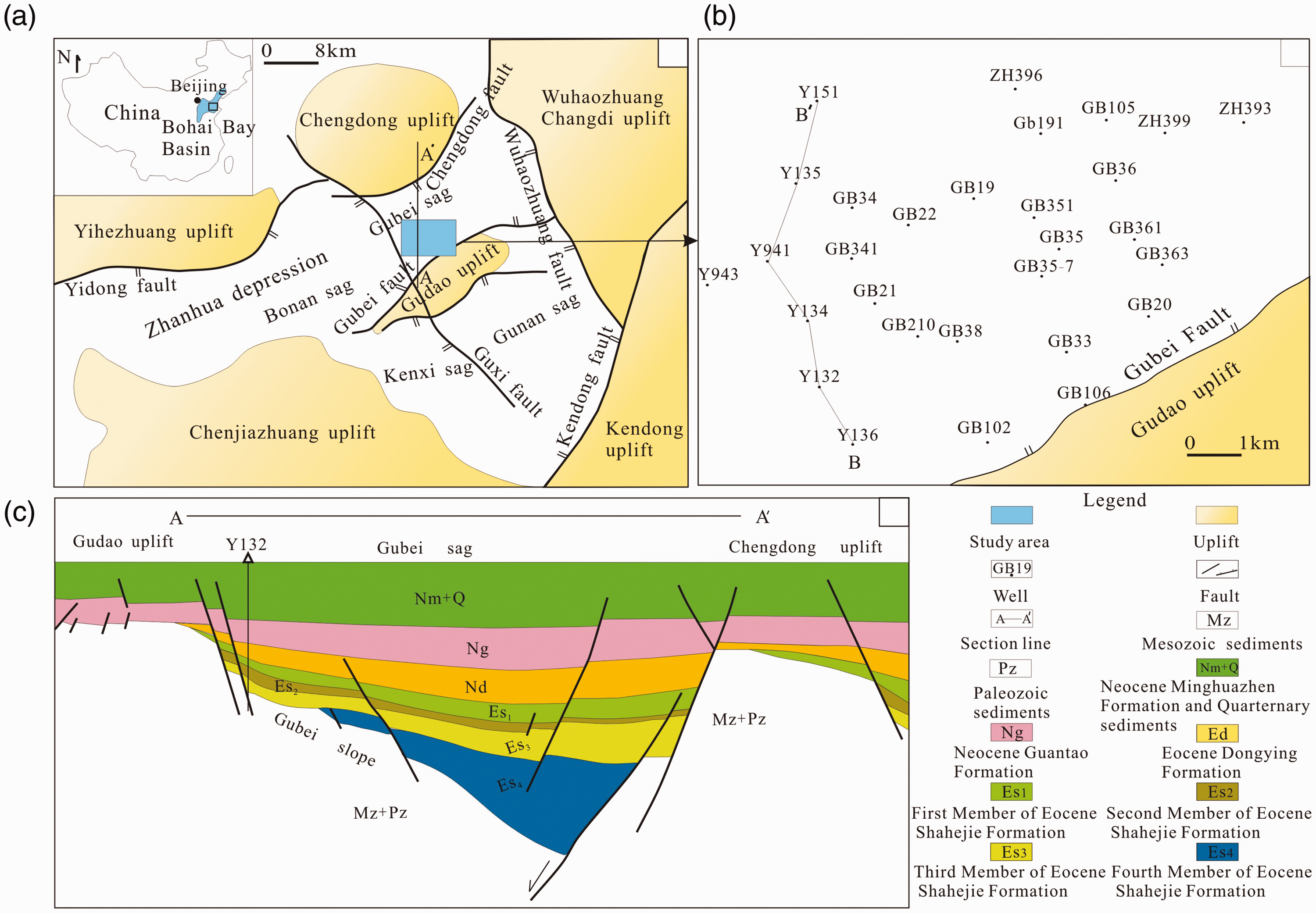
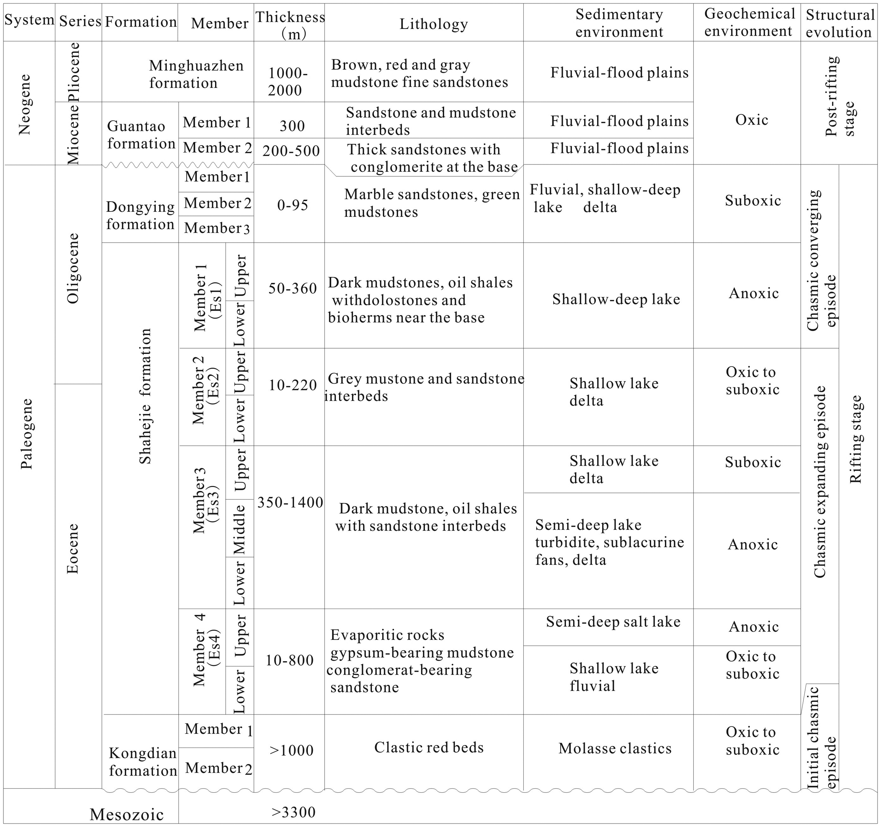
The Gubei Sag is a fault depression located at the northern part of the Gudao uplift (Figure 1a and b). The Shahejie Formation is widely distributed in this area, but is almost absent on structural uplift that separated individual half grabens (Figure 1c). This stratigraphic formation is further divided into four members, Es1 to Es4 from top to bottom as shown in Figure 2 and, among which the Es1, Es3, and Es4 contain commercial oil accumulation. The Es3 was deposited during the early to middle stage of the lacustrine basin development and it is characterized by the different subsidence of the fault depressions (Lin et al., 2004). Rivers originating dominantly from Gudao uplift in the south and Chengdong uplift in the north of Gubei Sag carried clastic sediments into the basin, resulting in delta, sublacustrine fan, turbidite, and lake fine-grained deposits. The Es3 with thickness 350–1400 m is dominated by deep/semi-deep lake organic-rich shale at the base, dark mudstones intercalated with turbidites in the middle section, and fluvial-deltaic sandstones near the top.
Dataset and methods
A combination of drilling cores, logging data, structural data, and 3D seismic data was generated during petroleum exploration and exploitation in Shengli Oilfield. The data were used here to study the depositional system, reservoir facies, and controlling factors of hydrocarbon accumulation. Over 300 m of conventional cores from 14 wells were described. Drilling cores collected from well GB102, GB35, GB38, GB210, GB351, GB341, and GB34 were used to identify sedimentary facies of braided-delta, sublacustrine fans, turbidite, and deep/semi-deep lake deposits.
As drilling cores are limited, lithological, 3D seismic, logging data, and structural data were used to determine depositional system and the controlling factors of commercial oil reservoirs. The logging curves and lithological association from more than 35 wells, including spontaneous potential (SP), natural gamma ray (GR), and true resistivity, were also used to identify depositional system.
After the depositional systems were classified, the multi-well section and contour of sandstone thickness were used to identify distribution of depositional system. Structure contour, distribution of reservoir facies, and faults were applied to assess the controlling factors of hydrocarbon accumulation in study area.
Results and interpretation
Depositional systems
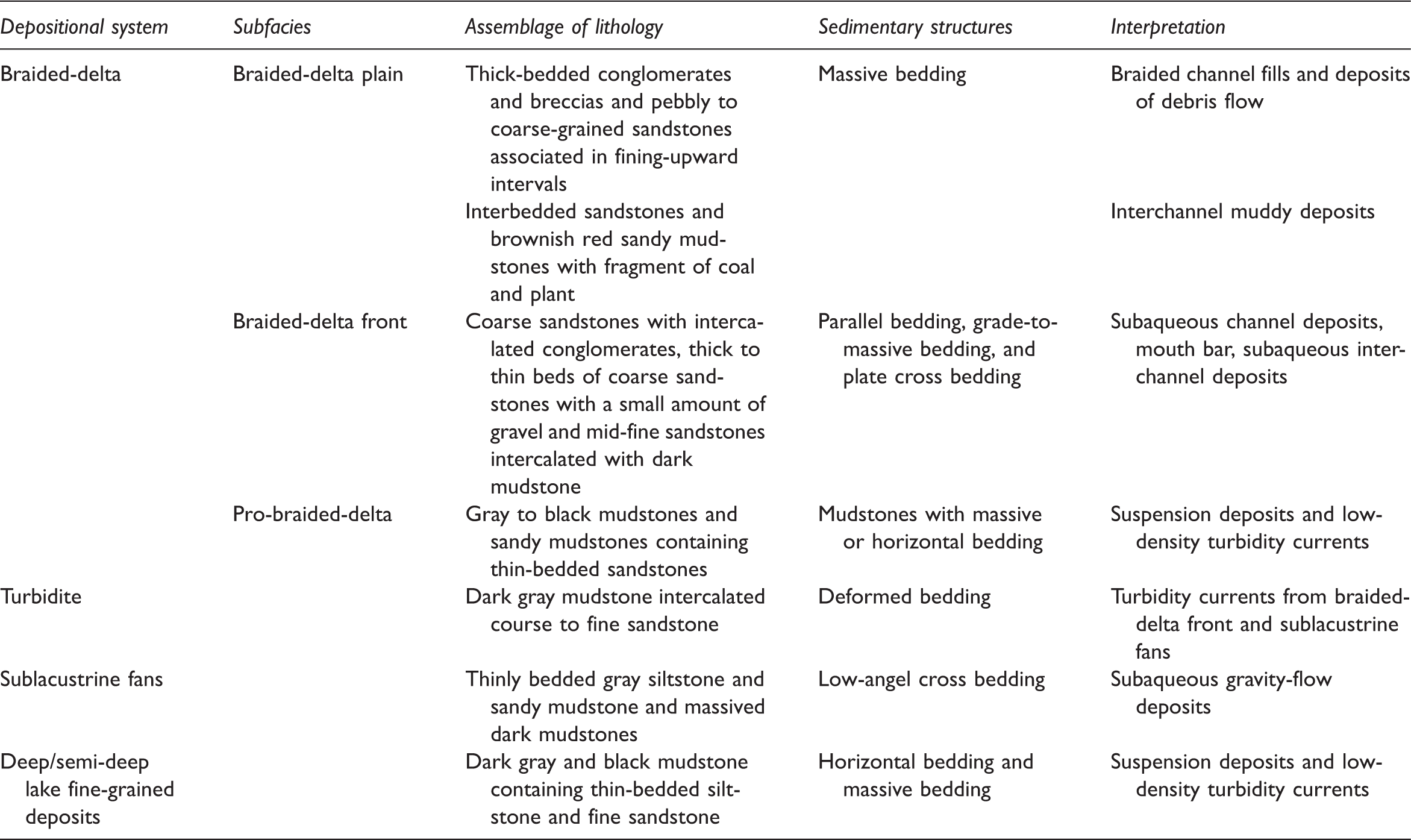
Depositional system, assemblages of lithology, sedimentary structures, and interpretation of sedimentary environments in Gubei slope zone.
Braided-delta deposits
Braided-delta deposits are widely developed in the third member of Paleogene Shahejie Formation (Es3). Braided-delta facies are located mostly adjacent to the southern hinged faulted margin that is located in the northern part of Gudao uplift. The braided deltas are characterized by grossly coarsening-upward successions consisting of subaerial (delta plain) and subaqueous (prodelta and delta front) subfacies (Figure 3) (McPherson et al., 1987).
Vertical successions of braided delta in Gubei slope zone. The figure is based on the observation of drilling cores and logging curves of well Gubei 102 which is located at faulted margin near the Gubei uplift. Well locations are shown in Figure 1(b).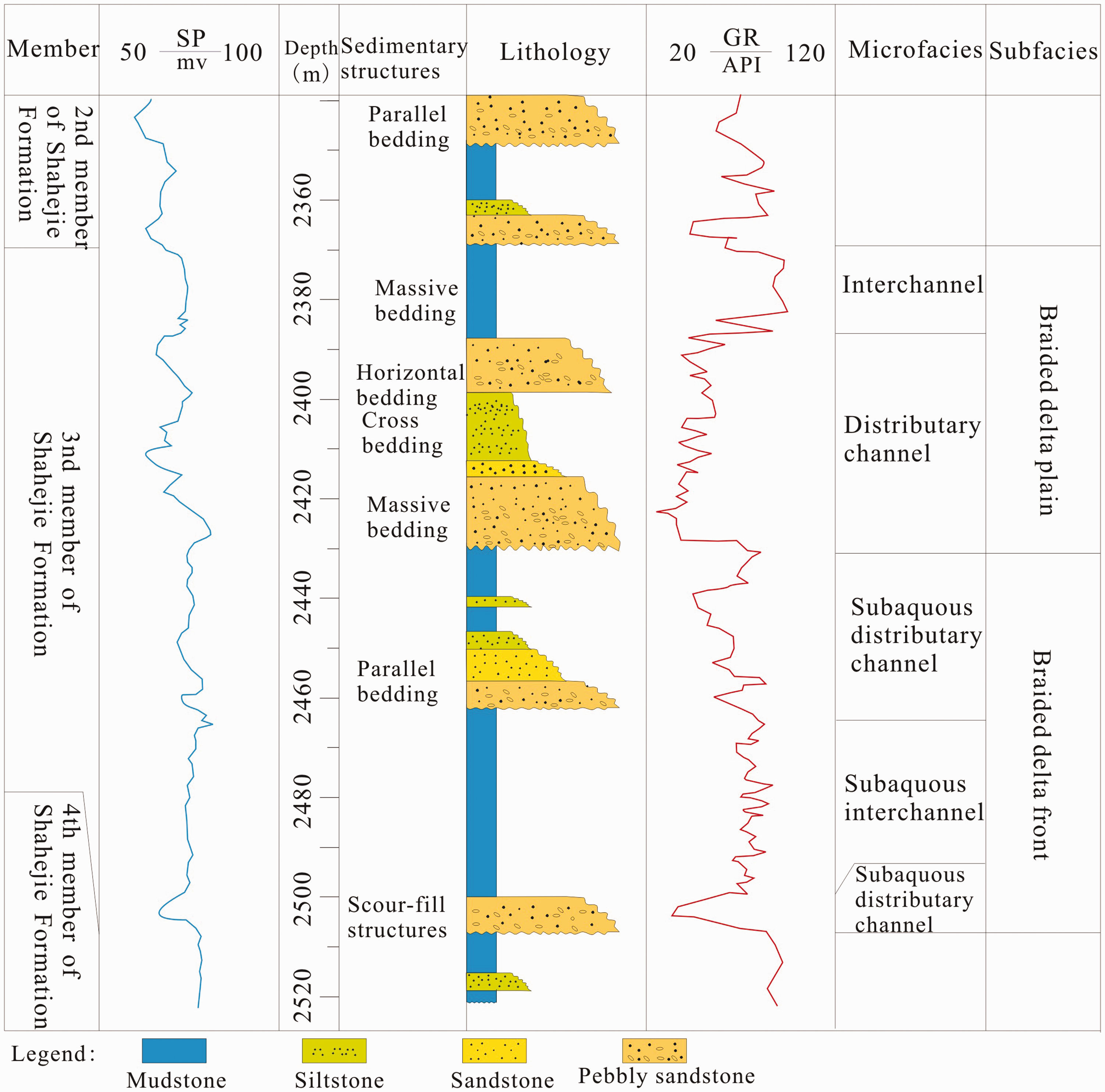
Braided-delta plain subfacies
Distributary channel fills reflect the attributes of the source fluvial system (Galloway and Hobday, 1996), and the colors of fine-grained sedimentary rock subsequently reflect the redox conditions during either deposition or burial. Red, brown, and yellow fine-grained sedimentary rocks are usually formed in oxidizing environments, while black and grey fine-grained sedimentary rocks are usually formed in reducing environments. Delta-plain deposits of braided-deltas in study area include: (1) brown and light grey mudstone with fragments of plant remnants (Figure 4a) and (2) upward-fining, conglomeratic sandstones, pebbly sandstones, and coarse-grained sandstones with parallel bedding (Figure 4b and c). These two lithofacies are interpreted as interchannel deposits that were deposited within distributary channels in braided-delta plain.
Typical sedimentary rocks and structures in Es3 of Gubei slope zone. (a) Brown mudstone with fragments of plant remnants, 2396.3 m, well GB102, located at the margin of the Gudao uplift; (b) grey and massive pebbly sandstones, 2399 m, well GB102; (c) grey coarse sandstones with parallel bedding, 2399.5 m, well GB102; (d) grey conglomeratic sandstones with scour-fill structures, 3005 m, well GB38; (e) grey medium sandstone with parallel bedding and black laminations consisting of carbon, 2955.5 m, well GB38; (f) light grey, pebbly sandstones with graded bedding 3003.5 m, well GB38; (g) grey, fine sandstone with wave bedding, 2794.5 m, well GB35; (h) grey, fine sandstone with some shale, 2791.7 m, well GB210; (i) black mudstone with carbonized plant debris, 2971.5 m, well GB351; (j) dark grey silty mudstone with bioturbation structures, 2977.5 m, well GB351; (k) grey, silty mudstone interbedded with sandstone and deformation structures, 2798 m, well GB35; (l) black mudstone, 3076.5 m, well GB341; (m) dark grey, fine sandstones with parallel bedding, 3462 m, well GB34; (n) poorly sorted, grey conglomeratic sandstones, 3117 m, well GB341; (o) poorly sorted, grey conglomeratic sandstones with large muddy pebbles, 3125.9 m, well GB341; (p) grey, conglomeratic sandstones in top and fine sandstones in bottom with scour-fill structures, 3489 m, well GB34.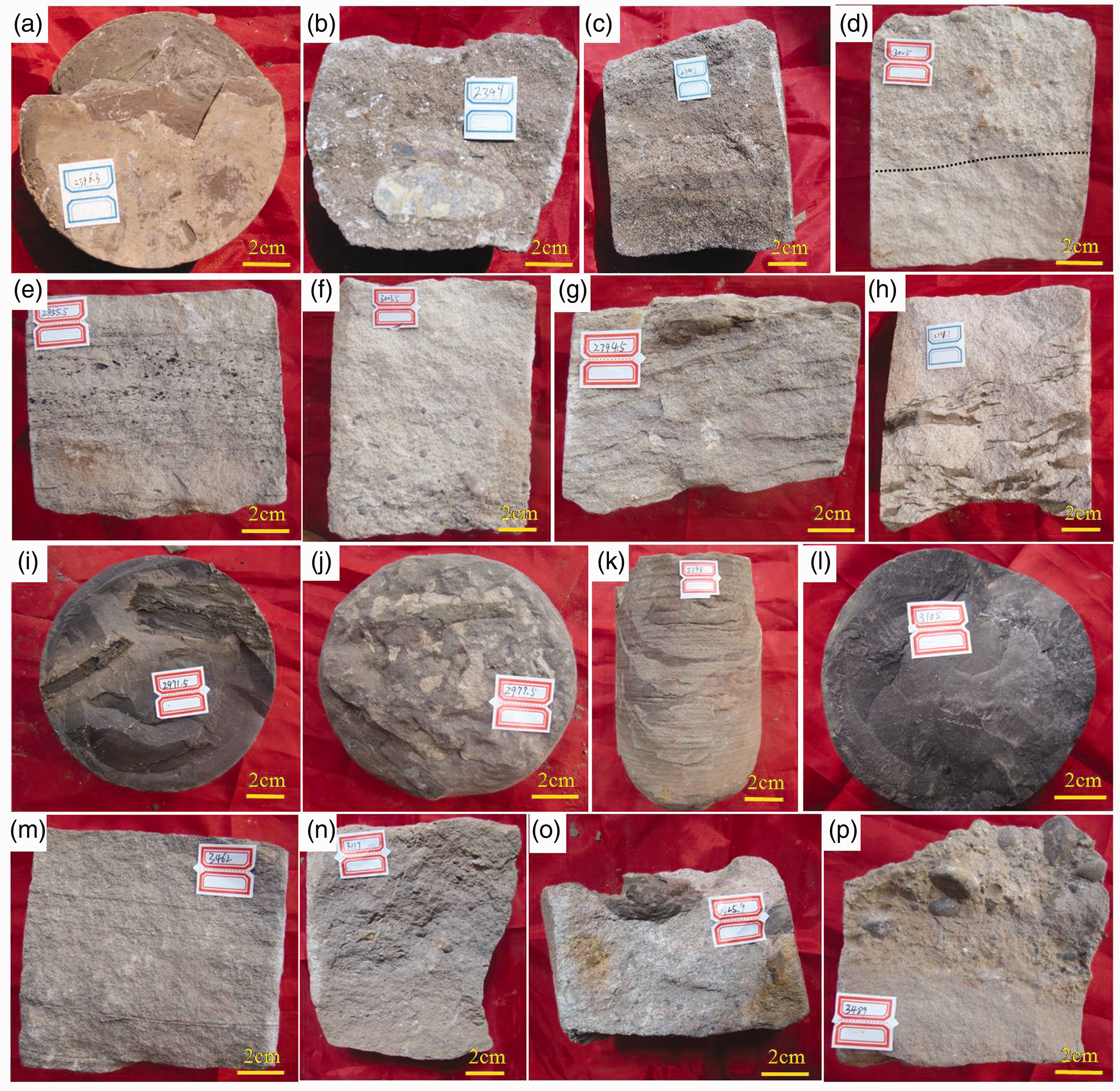
Braided-delta front subfacies
Delta front deposits in Gubei slope zone include: (1) thick-bedded conglomeratic sandstones and fine sandstones (Figure 4d); (2) thinly interbedded siltstones and fine-grained sandstones; and (3) thinly interbedded sandy mudstones and mudstones. The three lithofacies are arranged in 15–30 m thick, fining-upward parasequences that are interpreted as subaqueous channel deposits, and coarsening-upward parasequences that are interpreted as channel mouth bar deposits (Lindsay et al., 1984). In the depocenter, braided-delta parasequences and sublacustrine fans are generally stacked into aggradational parasequence sets up to 250 m thick.
In the study area, subaqueous channels are represented by the most developed microfacies in the braided-delta front. The channel fill deposits consist of interbedded conglomeratic sandstone, medium sandstone, and some mudstone, and the units are lenticular and nearly symmetrical in morphology. Primary structures are dominated by parallel bedding, graded bedding, and scour-fill structures (Figure 4d–f) which reflect the strong hydrodynamic conditions.
A channel mouth bar is typically created in the middle of a channel in a river delta (Edmonds and Slingerland, 2007). As the flow diverges near the lake, sediments settle out in the channel and create an incipient mouth bar. Channel mouth bar deposits are a typical microfacies in braided delta front facies. It consists of interbedded siltstone, fine sandstone, and some mudstone. The primary structures are dominated by wave bedding and massive bedding (Figure 4g and h). Wave bedding and rebuilt mudstone reflect the fluctuation of water flow. Probability cumulative grain size curves display two types of sediment, rolling-grain sediments and saltating sediments in channel mouth bar (Figure 5a). Generally, channel mouth bars are poorly developed in study area for the following reasons: First, the braided delta was controlled by fast-flowing rivers with high mobility which resulted in instability of the channel mouth, and large scale channel mouth bar was infrequently formed. Second, the slope in the north margin of Gubei uplift was separated by a series of faults, and large-scale channel mouth bar cannot deposit in this area.
Probability cumulative grain size curves of Es3 deposits in Gubei slope zone. (a) Probability cumulative grain size curves of channel mouth bar, from well GB341, at a depth of 3180.45 m; (b) probability cumulative grain size curves of turbidite, from well GB351, at a depth of 2800.2 m.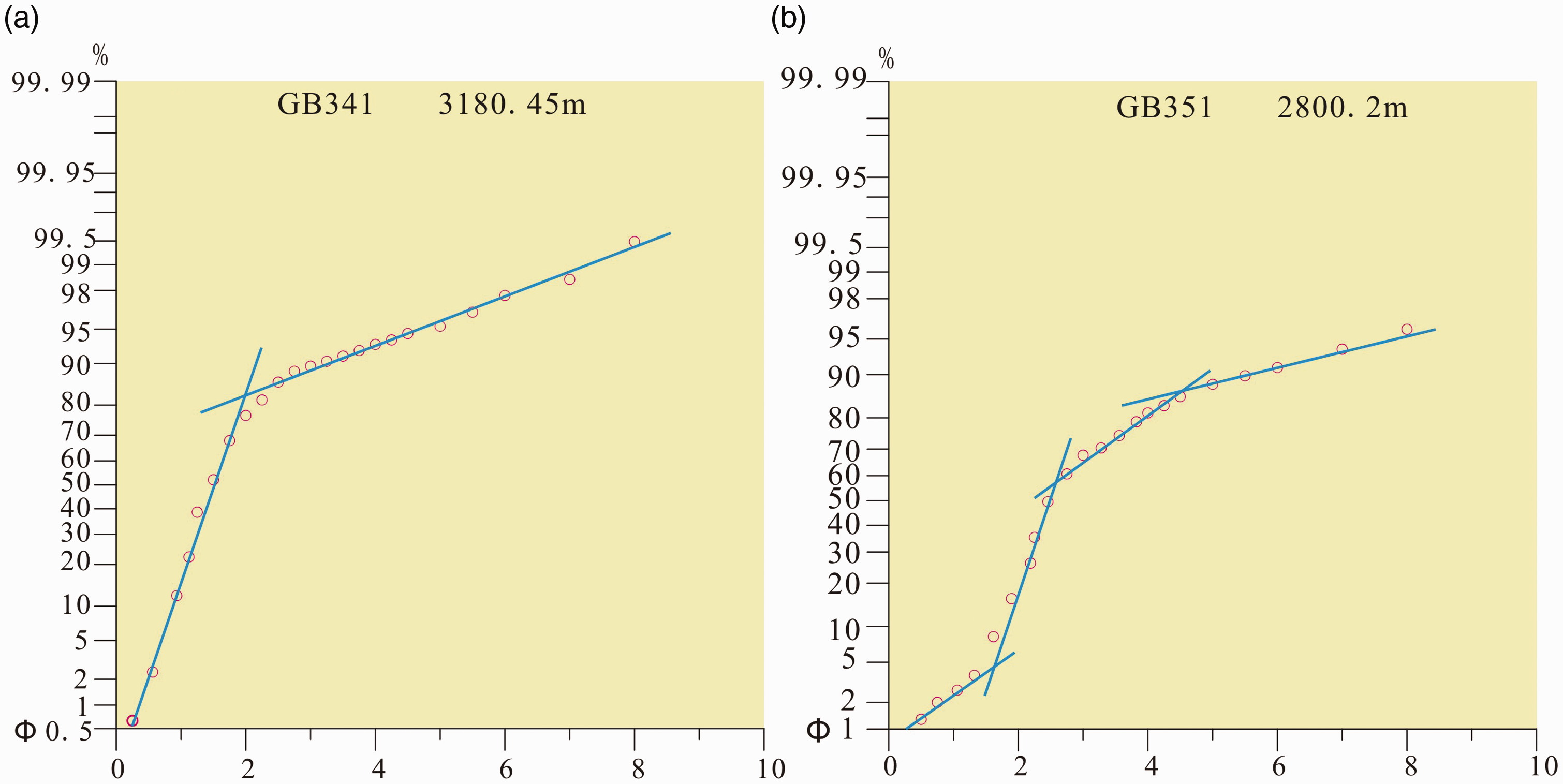
Subaqueous inter-channels that are developed in the braided-delta front consist of interbedded mudstone, siltstone, and some sandy mudstone in Gubei slope zone. Grey black mudstone with carbonized plant debris suggests a reducing sedimentary environment. Plant debris was carried by braided stream and deposited in weak hydrodynamic area. Bioturbation structures and grey color of fine-grained sedimentary rock represent a more oxidizing sedimentary environment (Figure 4j).
Pro-braided-delta subfacies
Pro-braided-delta deposits are dominated by black mudstones sometimes containing thin-bedded silty mudstones and siltstones (Figure 4l and b). The mudstones are massive or horizontally laminated, whereas the intercalated siltstones display graded bedding. Fine sandstones and siltstone beds are tabular to lenticular, 20–40 cm thick, and commonly display soft-sediment deformation (Figure 4k). The dark mudstones represent suspension deposits, whereas the graded sandstones and siltstones are interpreted as the deposits of low-density turbidity currents (Lowe, 1982).
Turbidite
Turbidity currents develop in the lake/sea from some form of catastrophic event that suddenly injects sediment into the water-sediment laden flood water entering the lake/sea (Kneller and Branney, 1995; Mulder and Syvitski, 1995). Causes of formation of turbidite in Gubei slope zone are as follows: (1) when sediment-laden flood water from a braided-delta channel entered deeper water in Gubei slope zone, leading to the deposition of a thick graded bed with basal coarse sand; (2) failure of weakly consolidated sediment in the hanging wall caused by fault activity or sediment load. The thickness of the turbidite range from 0.3 to 2.5 m and they are dominantly distributed in huge bedding of grey to black mudstone. Probability cumulative grain size curves consist of four sections, which indicate that the sediments are poorly sorted (Figure 5b). Sediments transported in the form of skipping and suspending are dominant, while rolling particle account for only a small portion.
Deep/semi-deep lake fine-grained deposits
Deep/semi-deep lake deposits are the predominant subfacies at the base of Gubei slope, near the center of the Gubei Sag. These deposits are tens to hundreds of meters thick, and characteristically display high GR and low resistivity well-log curves (Figure 6a). Their lithology consists mainly of thick beds of black mudstones (Figure 4l) and some thin, silty layers interpreted as low-density turbidity current deposits. Deep/semi-deep mudstones are interpreted as the hemipelagic fallout of suspended terrigenous sediments.
Correlation section from well Y136 to well Y151 (B-B′) (see location in Figure 1b). (a) Multi-well section showing reservoir facies and their distribution of the Es3 in the Gubei slope zone. (b) Tied seismic section B-B′ showing boundary of Es3 and its seismic reflection characteristics. The location of wells is shown in Figure 1(b).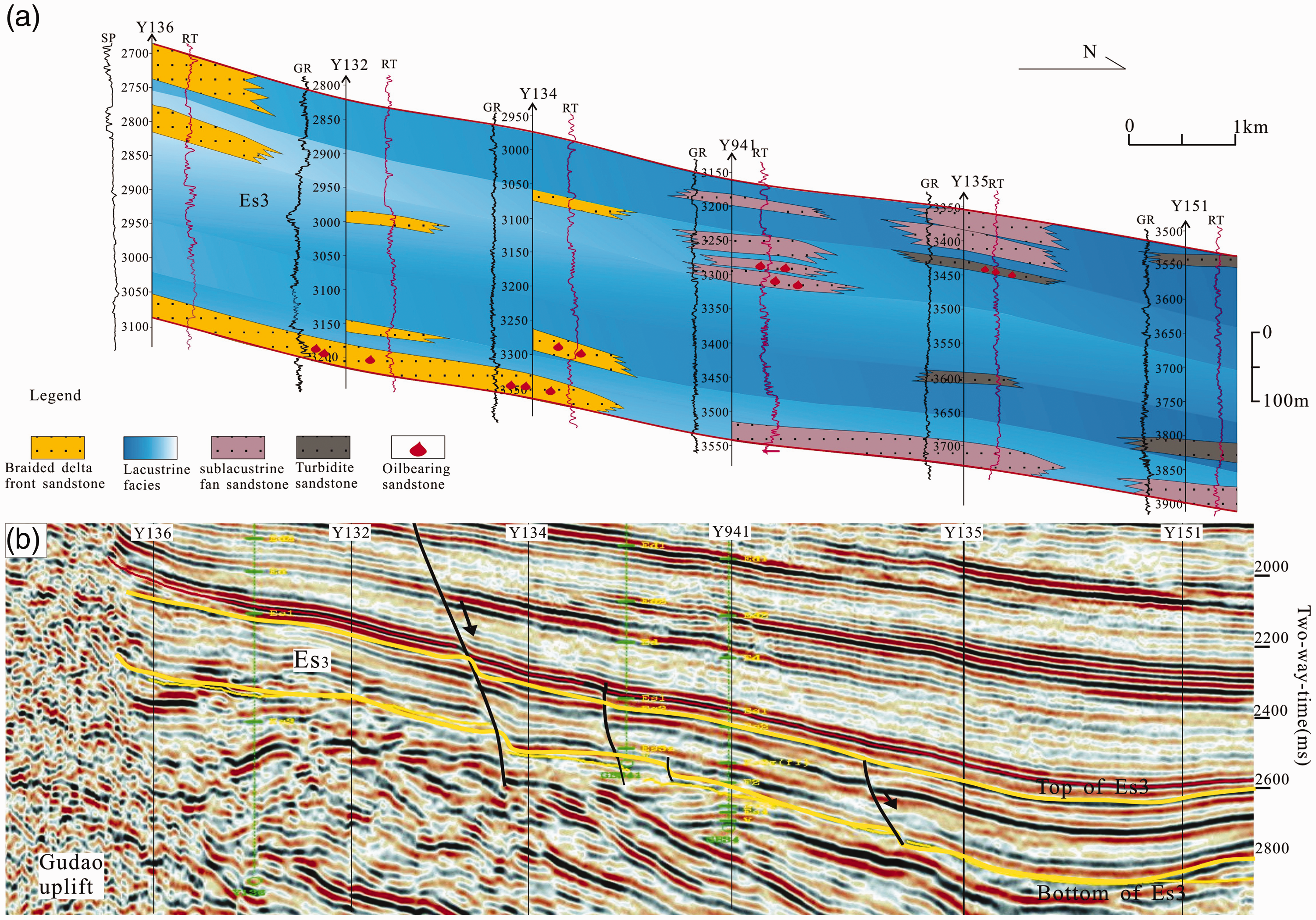
Sublacustrine fans
They consist of poorly sorted conglomerate to fine-grained sandstone overlain by black mudstone (Figure 4l and n). Furthermore, sublacustrine fans are defined here as subaqueous gravity-flow deposits formed in a sublacustrine environment. Sublacustrine fan deposits are mainly distributed along the margin of syndepositional faults. Such fans may be fed either by subaqueous channels ahead of braided-deltas or directly from incised channels at the margins of the faults. Muddy pebbles, scoured bases, and internal erosion surfaces appeared in main channels are distributed in sublacustrine fans (Figure 4o and p). The lithological assemblage of the sublacustrine fan displays a transition from a basal conglomeratic sandstone to parallel bedding fine sandstone (Figure 4m), overlain by black mudstone (Figure 4l).
Reservoir facies
A multi-well section and tied seismic section (Figure 6a and b) (see Figure 1a for the position of the section) were constructed to show the distribution pattern of reservoir facies along the slope zone. Reservoir facies distribution was obtained based on detailed analysis of drilling cores, multi-well sections, and sandstone thickness. Braided delta facies, mostly are composed of delta plain and delta front sandstone generally distributed in the north margin of Gubei uplift, while sublacusrine fan facies are distributed in front of braided delta, near the center of Gubei Sag (Figure 7). Turbidite facies are sparsely distributed in northern part of Gubei slope zone. Lacustrine facies mainly composed of grey mudstone are distributed in nearly all the Gubei slope zone, and part of them were favorable hydrocarbon source rock.
Reservoir facies distribution of Es3 in Gubei slope zone obtained based on core facies, logging curves, multi-well sections, and sandstone thickness.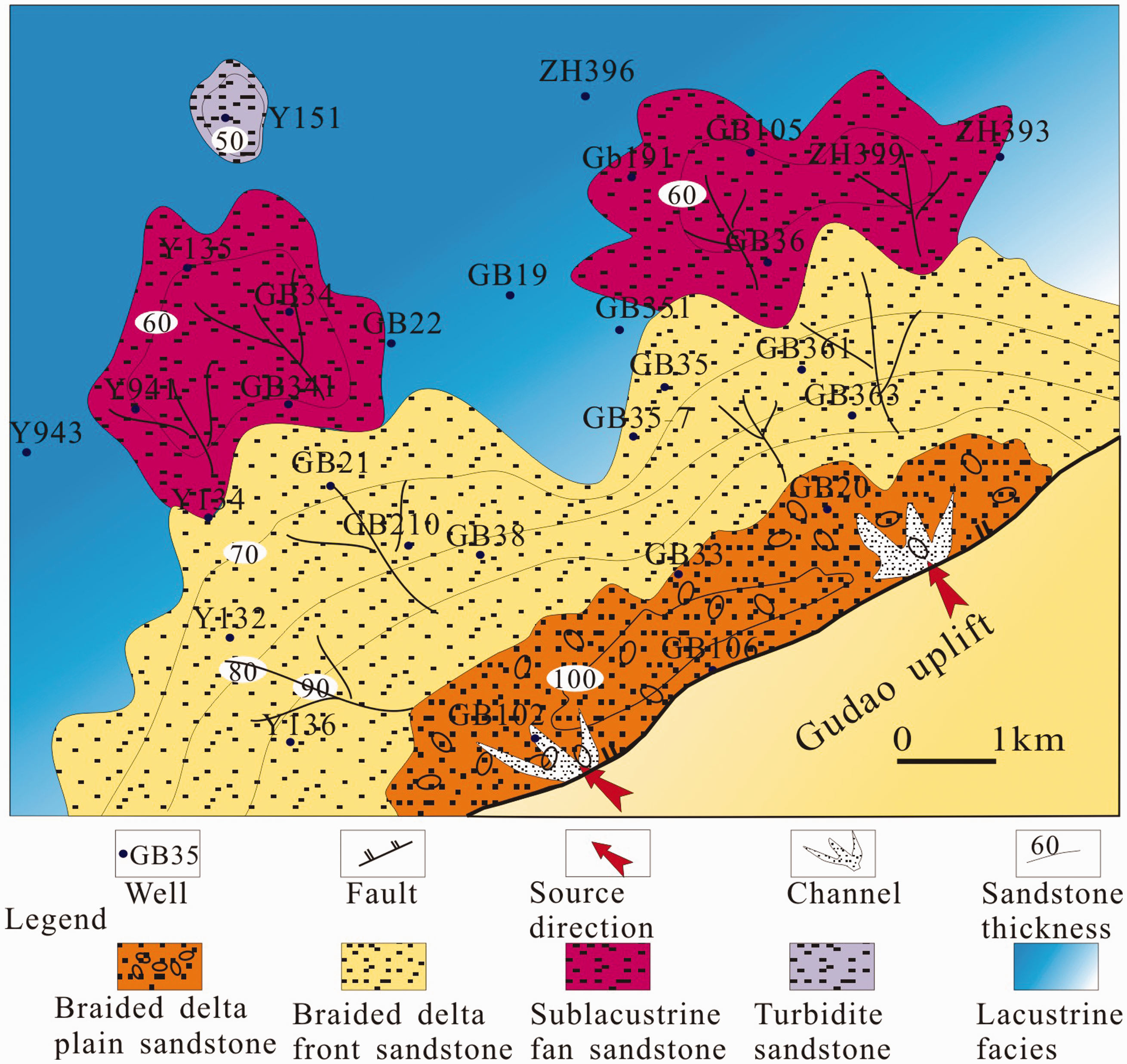
Fault system
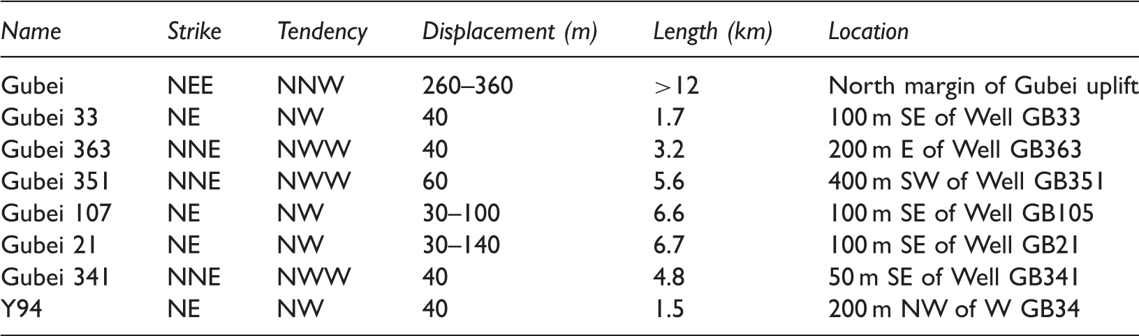
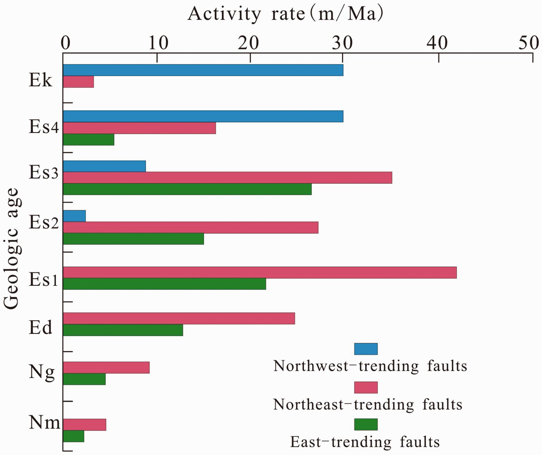
The formation of Gubei slope was dominantly controlled by Guxi fault, Chengdong fault, Gubei fault, and Gubei uplift (as shown in Figure 1a). The Gubei slope has experienced three times of tectonic movement stage, i.e. extrusion stage (late Permian to Triassic), tensional stage (late Triassic to Cretaceous), and extrusion stage (Tertiary) (Allen et al., 1997; Li et al., 2012; Qi and Yang, 2010; Su et al., 2009). These tectonic movements result in many faults in Gubei slope zone. The faults developed in study area are mainly distributed in northeast and east-trending (Figure 8a) areas and the detail characteristics of the faults are shown in Table 2. Liu et al. (2013) have examinated the thickness of some sedimentary body changes along transect of faults in Zhanhua Depression (Liu et al., 2013), and they suggested that most northeast and east-trending faults were active during deposition of the Es3 (Figure 9). These active faults are syndepositional faults and play an important role in the formation of depositional system (Lin et al., 2004).
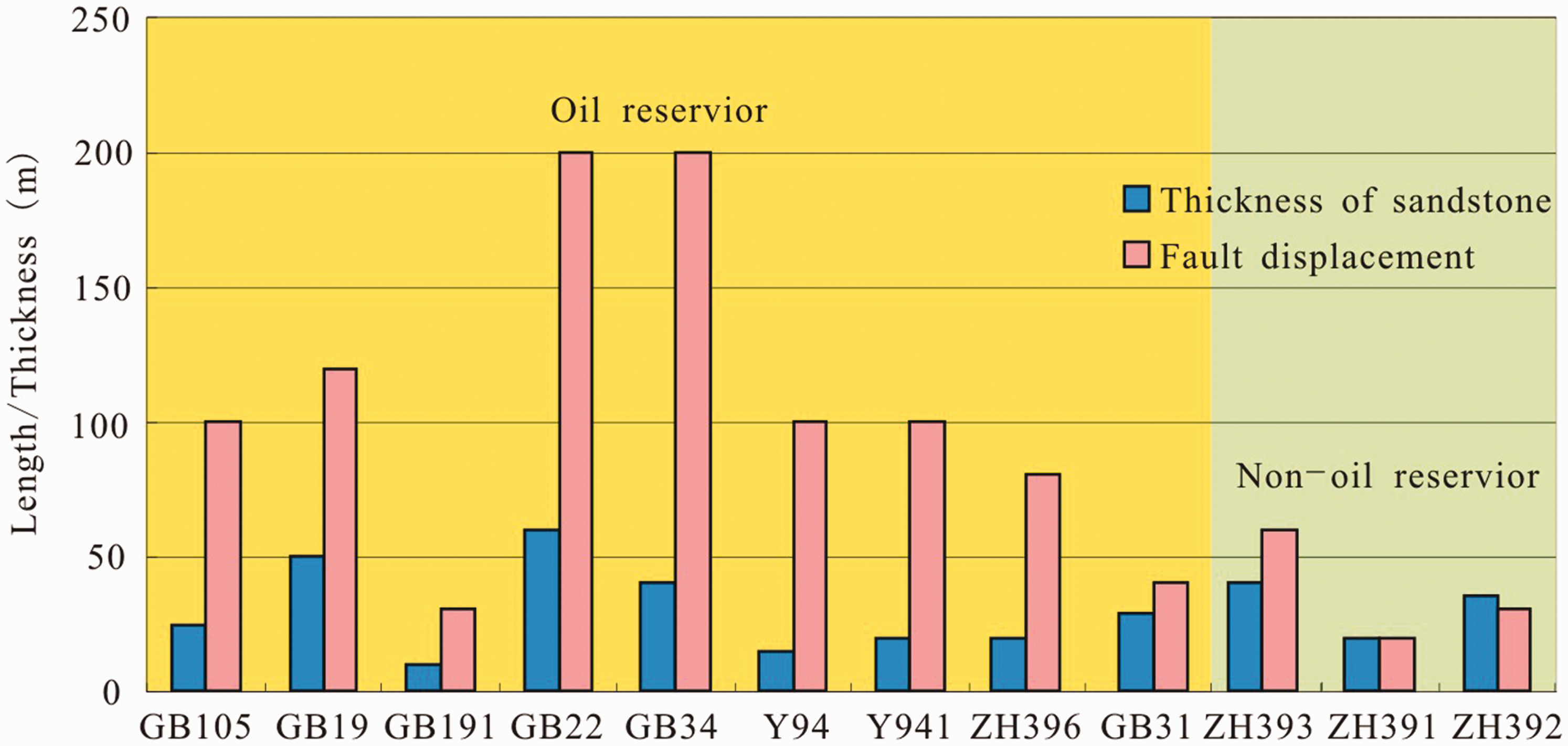
Distribution map of faults, commercial oil reservoirs, and structure contour map of the top of Es3 in Gubei slope zone. (a) Faults and commercial oil reservoirs distribution; (b) contour map of the top of Es3 showing ridge-like structure distribution. Characteristics of some main faults in Es3 in Gubei slope zone. Average activity rate of main faults in Zhanhua Depression in different stage (after Liu et al., 2013). Relationship between fault displacement, thickness of sandstone, and commercial oil reservoirs.
Discussion
The source rock of the Gubei Sag is distributed mainly within the Shahejie Formation, and coal-bearing rock series in Mesozoic and upper Palaeozoic stratum also provided some hydrocarbon (Wang et al., 2005; Yang et al., 2008). Previous studies have been confirmed that grey/black mudstone developed in Es3 and Es4 in this area are very good hydrocarbon source rocks (Wang et al., 2012). There is also enough sandstone which might be oil reservoirs as mentioned above. The main controlling factors of the formation of Es3 commercial oil reservoirs in Gubei slope zone are discussed as follows.
Reservoir facies
Abrupt lateral sandstone thickness changes are commonly accompanied by syndepositional faults in Gubei slope zone, likely reflecting abrupt lateral facies changes; these relationships are more common in deeper water zones. The exploitation results show that commercial oil reservoirs in Es3 distribute dominantly in sandstone developed in sublacustrine fans, braided-delta front, and some turbidite, and what accounts for this? The lithology varies in different fans, and even in sandstone in the same depositional body, which means that the reservoir facies changed rapidly laterally. For instance, commercial oil was found in conglomeratic sandstone (Es3 strata) in Well Y941, while there was no oil output (Es3 strata) in Well Y 943, even though they were in the same tectonic zone (Figure 8b). The reason was that facies deposited at the same time compared to Well Y941 was lake fine-grained mudstone that cannot serve as a reservoir.
Fault system
A favorable combination of source rock, reservoir rock, and cap rock is necessary for the formation of commercial oil reservoir (Aydin, 2000; Selley and Sonnenberg, 2014). Faults in Gubei slope zone might be the migration channel, while also probably serve as sealing unit. In addition, associated fault terrace zone provided accommodation for sedimentary body.
Faults within the slope area are major channels of hydrocarbon migration, especially the vertical migration of oil and gas (Jin et al., 2008; Karlsen and Skeie, 2006; Zhang et al., 2010). As shown in Figure 6b and 8a, Es3 reservoirs at the bottom of Well Y132 and Y134 were connected with grey/black mudstone by Gubei 21 faults; oil generated from these source rocks (grey/black mudstone, main source rock in this area) probably migrated into sandstone reservoirs through this fault. It can be concluded that fault system plays an important role in the hydrocarbon migration and accumulation in this area.
Relatively large (>30 m, see details in Table 2) fault displacement resulted in huge accommodation for fans and deltas, which provided enough accommodation for a series of sedimentary bodies and subsequent reservoirs and traps. In the 13 commercial oil reservoirs found so far, however, 11 oil reservoirs were located at the footwall of faults (Figure 8a). Moreover, faults could be lateral sealing unit for series traps including fault trap, fault-lithologic trap, and fault-nose trap. According to statistics of prospecting wells whose target stratum is Es3, commercial oil reservoirs can be formed when fault displacement is 2× larger than the sandstone thickness, such as Gubei 105 and Gubei 19 oil reservoirs (Figure 10). By contrast, if fault displacement is equal or smaller than sandstone thickness, commercial reservoirs cannot be formed, such as Gubei 31 and Zhuang 393 area (Figure 10).
Ridge-like structure
Faults which connected source rock and reservoirs likely played an important role in the vertical migration of hydrocarbons (Boles et al., 2004; Jiang et al., 2012). Generally, lateral hydrocarbon migration channels are influenced by stratum attitude, tectonic framework, and the distribution of dominant migrating channels, such as faults, unconformity, and sand bodies with good permeability (Gao et al., 2013; Ingram et al., 2004; Wang and Wang, 2013). The upper part of the slope is such favorable directional zones of hydrocarbon migration. The ridge-like structures identified by top depth contour of Es3 are shown in Figure 8b. Statistical results indicate that 12 of the 13 commercial oil reservoirs are distributed within ridge-like structures (Figure 8b). Hence, ridge-like structure formed in slope zone probably is one of the most important controlling factors in the process of oil reservoir formation, especially in small slope zone in continental basins.
Conclusions
Braided-delta, sublacustrine fans, and deep/semi-deep lake fine-grained deposits are dominated depositional system in the third member of Shahejie Formation (Es3) in Gubei slope zone, and thin-bedded turbidite generally interbedded with thick deep/semi-deep lake fine fine-grained deposits. Lithology variation between wells was mainly caused by depositional times and syndepositional faults, and it was one of the most important factors controlling the formation of commercial oil reservoirs. Fault systems are distributed widely in Gubei slope zone and some of them served as migration channels and sealing geologic unit. In addition, accommodation associated with syndepositional faults was suitable for the deposition of favorable sandstone sedimentary body. The statistic results show that most of the commercial oil reservoirs formed in the Es3 distributed in the footwall of the faults, which is in accordance with faulting. Most commercial oil reservoirs formed in the Es3 are distributed in the ridge-like structures in Gubei slope zone, which give an inspiration that ridge-like structure was probably a very favorable area for hydrocarbon exploration in continental basin slope zone.
Footnotes
Acknowledgments
Shengli Oilfield Company is thanked for their data providing.
Declaration of conflicting interests
The author(s) declared no potential conflicts of interest with respect to the research, authorship, and/or publication of this article.
Funding
The author(s) disclosed receipt of the following financial support for the research, authorship, and/or publication of this article: The study was sponsored jointly by the National Natural Science Foundation Project (41302076 and 41002043), MOST Special Fund from the State Key Laboratory of Continental Dynamics, Northwest University (BJ14266), Project Supported by Natural Science Basic Research Plan in Shaanxi Province of China (2014JQ5191), Scientific Research Program Funded by Shaanxi Provincial Education Department (16JK1788) and Specialized Research Fund for the Doctoral Program of Higher Education (20136101120003).