
Abstract
Scholars often describe the history of Transit-Oriented Development (TOD) from an exclusive urban development perspective (linear or finger cities) or from a limited mobility perspective (Public Transit). In these histories, walking is described as the yardstick for a station’s catchment area. Using primary sources, this article shows how between 1960 and 1990 the Dutch railroads played a forgotten but key and unique role in enriching the TOD concept in the densely populated Western Netherlands with the bicycle as a feeder mode. This created a spatial model of a belt with compact bicycle towns along railroad lines. In the process, the railroad reinforced by local and national policies since then helped create cycling-based rather than walking-based fifteen-minute cities that generated larger catchment zones.
Introduction
Today, Transit-Oriented Development (TOD) is hailed as the most sustainable solution to urban mobility challenges. According to American architect Peter Calthorpe’s classic articulation in 1992, TOD offered the best alternative to the car-oriented sprawl: “neighborhoods of housing, parks, and schools placed within walking distance of shops’ civic services, jobs, and transit—a modern version of the traditional town.” 1 The underlying idea, even though the term was not used, has a long history. The 1920s linear and “finger” city—transport lines spreading like fingers from the palm of a hand—expressed the first transit-oriented urban design, when city planners realized they could build accessible high-density places along public transit axes and create open spaces in between. 2 And pedestrians were the potential customers—or “feeders”—of these projected transport systems.
How to create seamless multimodality in TOD has puzzled planners and scholars alike. Transport scholar Friedrich Lehner, analyzing the best practices of more than sixty public transit organizations in twenty countries, recognized in the 1960s already that public transit’s greatest vulnerability is how travelers experience their points of transfer. Only by solving these transfer inconveniences could public transit seriously compete with the car’s door-to-door convenience, which, according to mobility scholars, best explains automobility’s triumph over public transit. 3 Since then, traffic engineers have studied the many obstacles to the ideal—a seamless experience of multimodal mobility for travelers’ journey from A to B—issues that go beyond time and money to include the subjective appreciation of waiting and discomfort at train stations. 4 Urban planners have also sought solutions focused on better connecting land use to transportation lines. In this quest, the Organisation for Economic Co-operation and Development (OECD), reviewing the urban planning scholarship in 1995, cited Copenhagen’s finger city, Vienna’s high density around stations, and Dutch location policy as models for a new land-use approach to offer smooth multimodal travel on public transit. 5 Yet, in both TOD theory and practice, urban planning scholars and policymakers have applied pedestrians as guiding principle. They took walking distance to the train station as their yardstick for the linear city’s width, but hardly ever considered cyclists as public transit feeders—a remarkable oversight. 6 So have transport scholars—except Grabe, Utech, Bovy, and Martens. 7
Nevertheless, scholars recently have referenced the Dutch case as a prime example of bicycle-oriented multimodality without explaining why and how the Dutch achieved their bicycle-based TOD. 8 This article retraces for the first time its origins to the 1930s to argue that bicycle-based TOD was neither a natural phenomenon nor a coincidence in the Netherlands. Rather, it was the outcome of long-standing social practice and deliberate planning policy—with the railroads as key institutional player. We show first how Dutch urban planners established the foundations for people’s journey to and from the train station by bicycle in the early 1950s already, and a decade later Dutch Railroad strategists discovered the bicycle as a promising “feeder” to compete with cars. The railroads staked out a leading role in developing TOD between 1960 and 1990 to beat off their rival, automobility. Along the way, rail planners assigned a prominent role to cycling, building on both social practice and theories dating back to the 1930s. Next, we show how since 1990, central government took over the railroads’ bicycle-friendly TOD policies. Together, these conceptional and institutional foundations helped transform Dutch communities into today’s fifteen-minute bicycle cities. TOD with Bicycle-Oriented Development (BOD) reinforced the seamless commuter experience of bicycle-train-bicycle multimodality. 9
TOD and Walking: International Theory and Practice before 1940
Internationally, three professions helped develop TOD theory and practice: urban planners, railroad strategists, and traffic engineers. Urban planners focused on the relationship between land use and transport. Arturo Soria y Mata, the first to take transport as a point of departure for urban planning in his 1882 Linear City (Ciudad Lineal) plan for Madrid, described how a railroad line held built-up areas together like a belt, making public transit more profitable than in a grid layout like Barcelona, and then calculated that the built environment, or belt, ideally had to be four hundred meters (a quarter of a mile) wide to make walking to the train station feasible. 10 Although his town planning colleagues criticized Soria for projecting the city along (rail) road infrastructures instead of improving the quality of the city, the International Congresses of Modern Architecture (CIAM) did place traffic’s role in urban planning—specifically people’s commute—front and center. 11 In his utopian Cité Industrielle (1904-1917), Tony Garnier combined Soria’s linear city with the CIAM notion of separating functions: a lateral tram system connected to a network of footpaths along the main streets at a walking distance (600 m) from stations—a theoretical articulation of TOD. 12 Some functionalist urban planners reintroduced Soria’s linear city with separate flows of cars and pedestrians (Le Corbusier); others focused on finger plans with public transit and walking (Schumacher in Hamburg, 1920; Rasmussen in Copenhagen, 1945-1947) and even bicycle-based urban plans (Th. K. van Lohuizen in Amsterdam in 1935). Designs in broad brush strokes were aplenty, with pedestrians as key feeders. Implementation was still the exception. 13
Railroad planners had been practicing TOD long before urban planners systemized it. After all, nineteenth-century railroad strategists had always been preoccupied with the logistics of who and how people get to and from the station—what they termed the “feeder system.” That search intensified in the 1960s when automobility threatened the railroad monopoly by creating car-oriented spatial development (“urban sprawl”): uncontrolled urban growth over large, low-density areas with long distances to urban services, car dependency, and unprofitable public transit. 14 The business model depended on customers living or working near—and with easy access to—the station. Planners and entrepreneurs sought railroad connections with high financial returns that would drive urban development. 15 In 1850s Paris, urban planner Haussmann located stations at the junctions of his new boulevards. 16 In early twentieth-century London, private investors such as financier Charles Yerkes bought land around planned subway stations, creating suburbs in the process. 17 And in Japan, railroad companies successfully exploited real-estate opportunities around stations in the 1960s. 18
Traffic engineering also played its part in TOD theory and practice. Traffic engineers began detailing how travelers got to the transit hubs. Carl Pirath at the Technical University Stuttgart examined the relationship between public transit and spatial planning. His 1934 handbook dealt with how land use and population density determined the potential number of passengers. He drew catchment areas with potential customers as circles around a station—a concept still used today (Figure 1). 19 Again, walking was at the heart of these proposals. In the 1930s, a few traffic engineers and social scientists discovered that workers had long been using the bicycle as cheap commuter alternative to public transit. 20 In his dissertation (1933), German civil engineer Hans-Joachim Schacht listed the bicycle’s many advantages as part of promoting cycling networks in the Ruhr area (Figure 2). 21 He calculated to what extent the bicycle widened the station’s catchment area and reduced workers’ commuting time. 22 Such insight into cyclists’ practices as feeders of the train system was rare. Even when 1930s Amsterdam planners used cycling distance as a means to expand the city, they did not take cycling trips to the station into account.
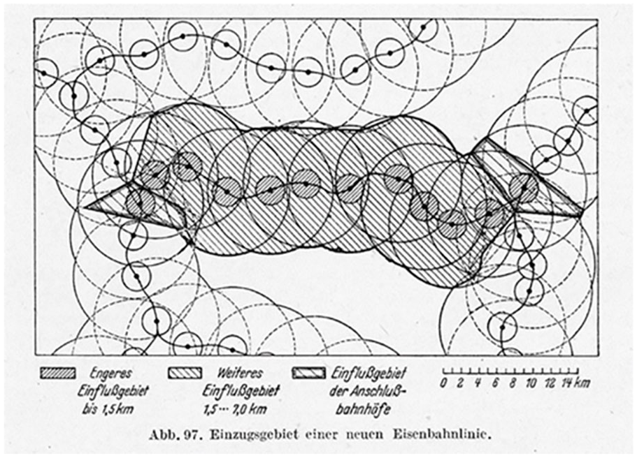
Catchment areas that Karl Pirath drew around German stations, a concept still used today (1934, reprint 1949).
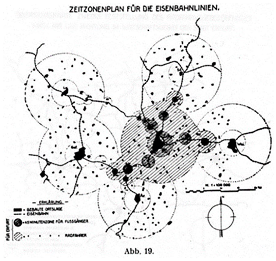
The different commuting times for pedestrians and cyclists extended stations’ catchment areas: Hans-Joachim Schacht, 1933.
In short, although urban planners, railroad strategists, and traffic engineers did consider pedestrians when developing TOD, they had little to say about cyclists. For their 1950s planning, Dutch urbanists were articulating more coherently a bicycle-based standard. Their thinking marked a departure from international trends.
Dutch Urban Planning, the Linear City, and Cycling, 1958-1966
Observing international trends, Dutch regional planners came to embrace TOD in their efforts to beat automobility in the 1950s. They saw not only walking but also cycling as a feeder and essential part of their TOD planning. Studying post-war challenges in 1958, the region planners believed that integrated spatial and transport plans were the best defense against increasing automobility and warned that the Netherlands should avoid the emerging car-oriented U.S. model as well as the unplanned growth and traffic congestion they witnessed in overcrowded urban regions such as Greater Paris and London.
23
In their view, foreign agglomerations of millions originate in one center and almost irresistibly expand further and further outward to an unmanageable size. With great difficulty, attempts are made to keep green belts free around the encroaching construction. The Dutch metropolis owes its history to an entirely different structure.
24
The country’s first national study on spatial planning “Linear Randstad” aimed to prevent the car-oriented urban sprawl. The polycentric urbanization of the Randstad—developed on elevated sites in the country’s delta region over centuries, encompassing four major cities, Amsterdam, Rotterdam, The Hague, and Utrecht, and their surroundings—was reinforced by the first railroad connections. 25
The regional planners were also fully aware of how crucial cycling would be for the viability of the Randstad’s mobility: “It is most welcome that the bicycle also continues to occupy such a large place in our country, especially in urban traffic and short-distance recreational travel. Without this, traffic problems would be even more difficult to solve.” 26 The 1950s planners realized that their TOD design principle enhanced this historically grown land—generating towns with enough jobs for residents, thus keeping commuting at bay. In doing so, they established favorable conditions for utility cycling 27 (Figure 3).
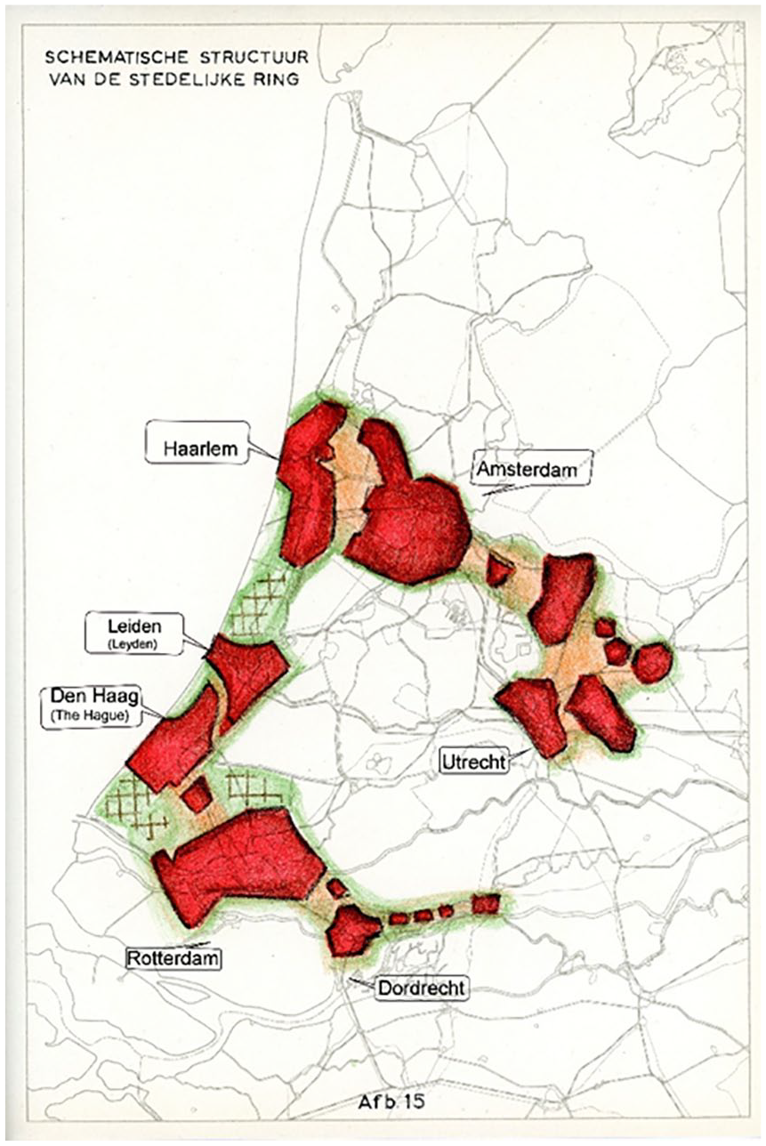
Proposed urbanization of the Randstad area (1958) with Green Heart.
The 1958 planners may not have been the first to understand the bicycle’s key role in avoiding urban sprawl, as we show elsewhere in detail. In 1935, CIAM chairperson Dutch urban planner Cees van Eesteren and his close collaborator social geographer Van Lohuizen had taken the comfortable twenty-five-minute commuter cycling distance as starting point for their Amsterdam extension plan—a blueprint that materialized in the 1950s with the regional planners’ bicycle-based planning standards for the Randstad. 28 In 1958, Randstad planners incorporated the Amsterdam bicycle standard in their regional TOD principle that went further, reinforcing polycentric development. They argued that bicycle accessibility determined the size of urban regions, guided by four standard measurements. First, from every point in the city, the outer area should be accessible by bicycle within thirty minutes (4 km). Second, a city’s population should not exceed 1 million. Third, an ideal belt width was 8 km, not the 600 m Soria had determined. Finally, the open space between cities should remain at least 4 km. 29 The bicycle standard had found its way to the urban region.
These measures differed from the international standards for belt and “finger” cities. Today, the standard belt width is half a mile, based on the walking distance to train stations—defined as the ideal catchment area. That is why Austrian urban planner and authority on belt cities Wilhelm Kainrath (1939-1986) failed to see the Dutch Randstad as a good example of TOD: it had “nothing in common with the belt city,” he wrote. 30 In using walking as a yardstick for his Linear City modeling, Kainrath ignored Dutch commuters’ long-standing practice of getting on their bicycles for the first-and-last mile of their ongoing train journey and the Dutch planners’ bicycle logic—later known as “chain mobility.” 31 Soon after, the cyclable urban planning standard went national. The government’s first Spatial Planning Memorandum (1960) took the 1958 linear city principle—combined with the bicycle-oriented urban standards—on board. 32 It was short-lived, however. Six years later, the government’s Second Memorandum on Spatial Planning (1966) abandoned the TOD principle, creating a blueprint for car-friendly New Town developments instead. 33
The railroads were not amused—and intervened. To level the playing field and beat the competition from automobility, their strategists embraced TOD strategy. Their interest in TOD developed when the railroads faced overall decline in the 1960s. The government’s car-oriented plans coincided with declining rail passenger journeys throughout Europe. 34 Dutch railroad strategists faced not only systemic financial losses but also the ideological competition from automobility boosters. The crises on both fronts prompted the railroads to explore systematically for the first time the relationship between urban planning and traffic: how could urban growth better align with the train system to attract and generate new passengers. Cyclists came into focus as a byproduct of this TOD thinking.
In the classic narration of mobility history, automobility overtook train travel, while the twin forces of cars and suburbanization emptied cities and undercut public transit. The Dutch case complicates this story in terms of both urban development and timing. In the 1950s, the polycentric Netherlands—and Italy—had the lowest car ownership rates in Europe, although their governments invested heavily in new highways to prepare for automobility. Only in the late 1960s did Dutch automobility take off, to quickly surpass train travel (Figure 4) particularly at city edges and in rural areas. Still, many cities were growing rather than suburbanizing along Dutch rail lines, allowing the rail authorities to retain a large market share. 35 At the same time, the rapid rise of automobility in the Netherlands’ many historic cities triggered activists to forge a coalition with historic preservation elites. In a broad-based social movement, the urban coalition instigated strict parking regulations to push back against the sudden and spectacular growth of cars in their city center. Rail and public transit benefited from these social and political forces within cities. As we will show, the railroads’ TOD lobby resonated with a rich Dutch planning tradition despite the national and international push for automobility. Concretizing the concept of cyclists as railroad feeders, however, happened in a more roundabout way and saw many detours.
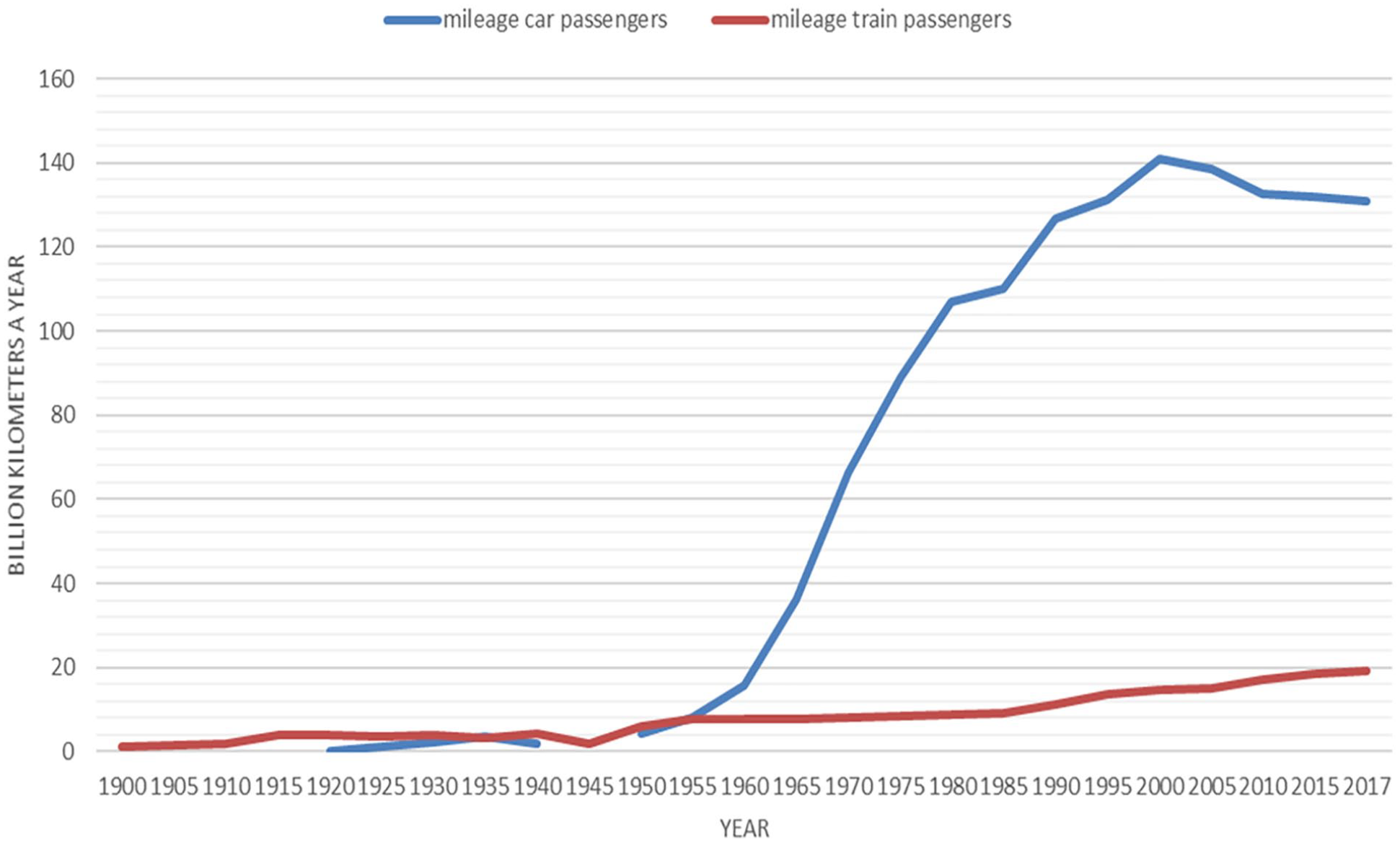
Annual kilometers of train and car passengers (1900-2019).
Railroads’ TOD Strategy against Car-Oriented Planning, 1962-1980
The Dutch railroads operation resembles national Belgian and Swiss systems, Île de France (Réseau express régional: RER) serving Paris and its suburbs, Greater London (London Overground suburban trains and TfL Rail), and Germany’s Ruhr area (regional trains Verkehrsverbund Rhein-Ruhr), serving a region with 17 million people. 36 Like Flanders in Belgium and Northern Italy—and unlike the Paris and London metropolitan areas—the Dutch urbanized area is polycentric, connecting cities by train. 37 In 1680 already, more than 70 percent of the population lived in twenty-three towns dotted over the western part of the Netherlands. 38 Since then, polycentric urbanization has intensified, reinforced by railroads linking dozens of towns. By 1960, 83 percent of the Randstad’s residents lived in towns and cities. 39
The Dutch railroads strategists, embracing TOD principles in earnest in the 1960s, were building on a long tradition in their sector. For their TOD strategy, the railroads strategists initially ignored the role their colleagues in urban planning had articulated for cyclists in 1958. The nation’s 1966 car-oriented policy—New Towns in places without rail connections creating car-based bedroom communities—prompted the railroads to intervene in the government’s spatial plans. They established a lobby to strengthen linear city planning. 40 The railroads had already set up a modest but active in-house research group to develop the TOD vision four years earlier in 1962: the Planning Research Commission (Commissie voor Planologisch Onderzoek [CPO]). Its mandate was to study how the railroads could stay profitable by adjusting to the changing mobility (cars) and shaping the government’s spatial plans. 41 Although the railroads had little decision-making authority regarding urban plans, their versatility while operating in a complicated governance of overlapping local, provincial, and national authorities meant they played a strategic role in postwar reconstruction modeling. As will become clear, the railroads planning committee shared high-quality knowledge, maneuvered subtly behind-the-scenes, and lobbied successfully, enabling them to incorporate their TOD ideas into the national spatial plans. The national railroads deftly tailored the TOD model to the circumstances in local communities and regions.
The Hague’s suburb Zoetermeer and the Utrecht’s suburb Nieuwegein best illustrate how the national railroads lobbied successfully to defend their interests locally, with walking as the implicit yardstick. Their research commission discussed urbanization plans with the Provincial Planning Departments, first with the country’s most urbanized province South-Holland which faced conurbation. 42 The village Zoetermeer was scheduled to become a bedroom community, with hundred thousand residents commuting to the city of The Hague by car. Although this short-distance route was a local governance matter, the Provincial Planning Commission got involved after the railroads’ research commission member Frits van Strien had warned against conurbation’s commuter traffic in 1963, insisting that Zoetermeer’s urban development needed a light-rail connection within walking distance. In less than a year, provincial planners adopted his idea of a new railroad loop through Zoetermeer, which opened in 1977—the country’s first new line since 1934. 43 Next, the railroads research commission zoomed in on the suburbanization plans for the city of Utrecht’s satellite town Nieuwegein, convincing provincial authorities in 1963 to create better rail access by integrating urban and transport planning. 44 The railroads’ behind-the-scenes maneuvering resulted in the construction of a light rail line to Nieuwegein twenty years later (1983). These strategists also took their TOD lobby to a national level, entering the transport discussions around Amsterdam (Schiphol Airport Line and the Amsterdam Ring Railroad). 45
The successful interventions led the railroads to invest in TOD by recruiting urbanists as well. In 1964, the research commission CPO hired planner Wali van Lohuizen, son of Th. Karel van Lohuizen, pioneer of the twenty-five-minute (maximum) cycling commute in Amsterdam. The railroads explored and published about TOD in the Dutch Society of Urban and Housing Planners (Netherlands Institute of Planning [Ruimtelijke Ordening] and Housing [Volkshuisvesting][NIROV]) circles. Three years later, the society held a symposium on the subject. The prominent magazine Urban and Housing Planning (Stedebouw en Volkshuisvesting) devoted a special issue to the relationship between spatial planning and public transit, celebrating how the railroads’ engineers had abandoned their narrow technocratic focus to embrace a truly integrative approach to planning. 46 The railroads’ strategists expanded their urbanist horizons: they visited belt cities in Poland and Russia, studied German cities where the pedestrian was a regional public transit feeder, and explored the New Town development in the United Kingdom. 47 In short, by the early 1960s, railroad strategists and urban planners had finally found each other.
Political events, however, prompted Dutch railroads to make TOD planning the company’s survival strategy beyond the academic niceties. Not only had the government issued the car-oriented New Town planning framework in 1966, but a year later, anti-rail conservative junior minister Mike Keyzer pushed for cutbacks and demanded that the railroads were no longer run as a public service. 48 The minister made it clear that building new lines was out of the question: railroads were a mode of transport from the olden days. 49 Subscribing to automobility as the mobility for the future, his conservative cabinet instigated an ambitious National Highway Plan to construct 3,200 km of new roads on top of the existing 2,100-km network. 50 In 1967, the railroads cargo division lost its highly lucrative contract for coal transport. 51 Within months, the railroads board established a “steering committee” (Stimurail) to improve efficiency and sent the Minister a defensive memorandum “Future of N.V. Nederlandse Spoorwegen,” painting a bleak picture. 52 Two months later, the board upped the ante by commissioning a plan with a much broader vision that rejected national policy. If the railroads helped solve the country’s urbanization and mobility problems, that would demonstrate their social importance and justify government funding. More concretely: how could the railroads get car drivers to take the train? 53
Within two years, the railroads had implemented the TOD vision as their core strategy. In 1969, steering committee Stimurail had rapidly presented a new vision integrating much of the research commission’s thinking on TOD: Rail to ‘75 (Spoor naar ‘75) with a new timetable (Spoorslag ‘70). For the first time, the railroads addressed the issue of transport integration, realizing that access and egress transport were their Achilles heel: they emphasized their relationship with spatial planning, based on the station catchment area concept. 54 The railroads’ report warned about the dire consequences of monofunctional satellite cities and locating new urbanization at a great distance from the rail network. The train, according to the authors, was the right solution to mass commuting by car. 55 In formulating the new strategy, Dutch railroads used the insights from the international platform of regional and urban transport companies UITP (International Union of Public Transport), which had put the problem of rising car use competing with public transport on the agenda as early as 1955. 56 Their studies called the combination of different modes of transport “broken mobility” before introducing the terms multi-modality or chain mobility. 57
The strategists were inspired by international examples. In their 1972 publication Waar moet ‘t heen (Where to go), the Dutch railroads lobby referenced Jane Jacobs, Victor Gruen, and Colin Buchanan to warn that without an alternative Dutch transport policy, cars would dominate the roads. The lobby mobilized OECD reports, Ralph Nader’s work, Lewis Herber’s writings, and Hans Dollinger’s Die totale Autogesellschaft to warn against the environmental damage of car traffic, especially noise and air quality, and to propose public transit as the alternative. Due to the lack of scholarly journals on public transit, policymakers read German magazines such as Der Stadverkehr and Verkehr und Technik to stay up to date with German urban developments in light rail keeping city centers like Karlsruhe livable, and Peter Hall and Carmen Hass-Klau’s comparison of British and German approaches to planning. 58 These international publications paid a lot of attention to high density around stations, the importance of pedestrians, and the Park-and-Ride opportunities. They all ignored cycling. Within this international dialogue, the Dutch railroads planners uniquely discovered the important role of cycling in their TOD thinking—a discussion that had started among urbanists, but now found a powerful player. The railroads’ in-house discussions about cycling practices would take over two decades to materialize.
Positioning the Cyclist as Feeder, 1970s
The Dutch railroads established a Research and Planning Department in 1970 to implement the TOD vision. Led by lawyer Pieter Leopold, the department was modeled after the think tanks at Dutch multinationals Shell and Philips. Leopold’s small group of young innovative thinkers soon expanded to a hundred research and development staff, with two key divisions for TOD: Piet Breedveld, continuing the research commission’s work on TOD, headed Regional Planning. Traffic engineer Maurits van Witsen, leading Strategic Planning, concentrated on the national lobby. 59 Both divisions proved important for improving the multimodal connection between cycling and train travel.
Van Witsen’s strategy division critically reviewed national policy and lobbied MPs. 60 Like the 1958 Randstad planners, his division routinely referenced the U.S. unplanned urbanization and suburban sprawl as the model to avoid, promoting the benefits of polycentric spatial planning compared to monocentric London, for example, with an illustrative overlay covering Utrecht’s medieval city center to show how much land was used for the Oudenrijn flyover junction planned nearby. 61 The planners gratefully cited urbanist Peter Hall, who in 1966 described the Randstad—like London’s conurbation—as a “World City,” praising its polycentric character. In his view, the Randstad resembled Ebenezer Howard’s ideal for growth: a high-quality transit system connecting compact cities that could become the powerful, economically cooperating polycentric city (Social City). Urban planner Hall, like Kainrath, did not mention the cyclists’ role in the Randstad urban development, but appreciated their TOD qualities. 62 It took new insights from traffic engineering about multimodality to make cyclists a serious topic of investigation.
Cyclists came into view when the railroads’ strategists created a model for multimodality: people’s practice of combining different transit modes to get from A to B. The government established the Project Bureau for Integral Traffic and Transport Studies (Pb-IVVS), after Public Works admitted during a parliamentary debate that the National Highway Plan (1968), proposing 3,200 km of new highway, was substandard. This bureau—focusing on integrating different transport modes—gave Dutch railroads a strategic opportunity to shape the government’s planning and mobility departments with relevant ministries. 63 One member recalled their outsized power: the railroads “didn’t pay but had a substantial influence.” 64 Railroads engineer Rudie Hamerslag in Van Witsen’s strategy division was the first to model the problems on journeys sequentially by applying a “chain mobility” concept. He also modeled the interaction between the use of public transit and the car (multimodality). His integrated approach was innovative: international traffic models focused either on automobility or on public transit, but never multimodal networks. The government’s project bureau commissioned consultancy firm NEI, which applied Hamerslag’s model in the first national study. 65 The bureau conducted research on chain journeys with access and egress transportation—a novel idea that later shaped national policy. Hamerslag’s model was consequential for cycling.
The Hamerslag model, for example, showed that cycling was faster than walking for getting to the station. Van Witsen’s research group thus discovered the importance of the bicycle as effective public transit feeder. The strategy division published its cycling research findings in Dutch and German journals. 66 Their insight of how cycling served as a feeder found its way to German colleagues in Hamburg, where planners were converting the German city’s 1920 Achsenplan to one based on densification (“Hamburger Dichtemodell”), with multifunctional towns along the S-Bahn axes within a 600-m walk to subway stations. Reinforced by their own research, the planners at Hamburg Transport Association (Verkehrsverbund HVV) built bike parking garages at several stations. 67 Both Hamerslag’s model for multi-modal trips and the exchange with Hamburg concentrated on cycling’s potential feeder role for TOD.
At first, Van Witsen’s in-house influence in articulating the role of cycling was limited. The company planners had a general understanding of how many commuters cycled to stations to catch a train, but they did not believe cyclists needed any special prompting or planning to use the train—except for securing bicycle shelters at stations. The railroads’ economists viewed pedestrians living near the new suburban terminals as potential customers, showed an interest in public transit (bus and tram) as egress transport, projected that cabs and cars would become more popular for getting to the station, and experimented with Park and Ride. They proposed that intercity trains stop at the new suburban town Haren, for example, because of its Park and Ride, and created this facility at other stations. Still, cyclists were not routinely part of their equation. It took almost twenty years for Van Witsen’s division to successfully convince the railroad organization of the bicycle’s importance as feeder.
In the meantime, Piet Breedveld’s regional planning division, expanding on the urban planning lessons learnt in Zoetermeer and Nieuwegein, also advocated cycling and pedestrian access. Like the predecessor research group CPO, his division systematically reviewed city zoning plans to make them compatible with the railroad network. He divided the country into study areas to assess communities’ expansion plans and then instructed his staff to seek opportunities for opening suburban rail stations. The staff’s preferred strategy was raising objections to local zoning plans under national rules: putting pressure on councils that failed to include traffic and transport in their policymaking. The division tried to lobby for higher density building around stations. 68 For example, they approached planners in Amersfoort about the one-sided development near the town’s Schothorst station and Delft authorities on the orientation of walking and cycling routes at Delft-Zuid station. They also advocated constructing direct cycle routes and footpaths to the station as good practice but not as a design principle. 69
By the 1970s, Dutch railroads took a more systematic approach to cycling when bicycle activism heated up across the country. They supported studies on station-oriented bicycle structures and commissioned urban design bureau OD 205 to devise a traffic plan for the small town of Schagen in North Holland (“U-turn in traffic”). Transport and urban planning firm AGV—the railroads’ former in-house consultancy—designed an integrated subway and bicycle plan for Spijkenisse. 70 In 1980, the railroads published a richly illustrated booklet featuring a study by Jan Wittenberg, whose design for the city of Leiden’s Stevenshof neighborhood was part of his research at the University of Delft. 71 It featured radially oriented cycling routes leading to the station, with housing built along the cycling axes and around the station. Wittenberg, who also served as the first president of the Netherlands Cyclists’ Union (Fietsersbond established in 1975), had observed the railroad planners’ practices at Houten, the Utrecht satellite town. His thesis articulated the cycling orientation he had seen in Houten, which he applied as general principle to the city of Leiden. In Houten’s design, urban planning, railroads’ TOD strategy, and traffic engineering models came together to facilitate cycling in a unique fashion.
Houten as Icon of Bike-Train-Bike Integration, 1973-1982
The Utrecht satellite town Houten acquired a strong bicycle-train-oriented design as a direct result of the Dutch railroads’ lobby. The town synthesized new urban planning and traffic engineering ideas that had been decades in the making. Years before activists formally formed the national Cyclists’ Union in 1975, railroads planners had tried to integrate cycling into their TOD designs. In their 1969 vision for the future (Rail to ‘75), the railroads strategists aimed to create high-density urbanization near railroad hubs, citing Houten as the “right” model (“The satellite town of Houten, which we continually promote, does not pose any transport problems: the railroad line is already there”) and the suburban town Nieuwegein as the “wrong” model. 72 When steering committee Stimurail looked at potential stations and inventoried planning actions that year, Utrecht’s satellite town Houten was on its high-potential list. 73
The railroads strategists followed suit. 74 In May 1973, railroads planners Breedveld, Hans Ridder, and Jos Klein Tank met with mayor Willem Bijleveld, policymaker Haan, and consultants Wim Wissing and Robert Derks to discuss the zoning plan for Houten. The consultants presented a broad elliptical shape and park-like structure for twenty-five thousand residents, with a car-free high-density center within walking distance, but a western development 2 km from the new station that residents could only reach via a combination of bus and cab. 75 The railroads planners insisted on more housing within walking distance of the station, relocating the station, and constructing cycling and pedestrian paths leading diagonally to the station—design ideas that Wittenberg systematized in his MA thesis for the Leiden case study. 76
The railroads were meanwhile going full speed ahead with their TOD lobby to include cycling as first-and-last mile solution despite national government constraints. In 1976, Breedveld had to admit that the railroad’s “hands were tied” because the minister would only grant permission for a station in Houten if the plan was financially viable. However, when consultancy Goudappel Coffeng (BGC) advised a car tunnel near the train station instead of a ring road around the town center, with a local bus as before-and-after transport, the railroads tried to change the pedestrian-oriented plan to a bicycle-oriented one. Calculating travel time rather than distance, the railroads planners argued that with the bicycle as feeder, the station’s catchment area would increase sixfold. In this way, the town, with a projected population of sixty thousand, would not need an extra station. 77 By spring 1977, railroads director Leopold asserted that opening a station in Houten would be feasible, even if the town ended up with only nine thousand residents: its center with attractive walking and cycling routes, he insisted, would improve the cost-benefit ratio. 78 Soon after, even the new magic number of nine thousand residents was no longer a precondition—bicycle parking spaces at the train station should be realized prior to accomplishing the threshold for urban growth. After a decade of ad hoc consultations, when an integral planning project group “Greater Houten” (Groot Houten) was established, it axed the “buxi” transport that Goudappel Coffeng consultancy had advised. Cycling and walking had to bridge the first-and-last mile of people’s journeys. 79
The Dutch railroads’ gamble paid off. After the train station was opened in May 1982, rail journeys per thousand residents were significantly higher in Houten than elsewhere. Perhaps more importantly, train use was double the original catchment theory projection. Automobility, in comparison, was 25 percent lower than average for a new town. Thanks to the ring road, the town was almost car-free and the number of traffic accidents significantly lower than elsewhere. 80 Since then, scholars have hailed bicycle-friendly and TOD-oriented Houten as the model of the future. The town was twice named Dutch “bicycle town of the year.” 81 The railroads’ lobby for Houten as bicycle-friendly TOD town was also successful on account of shifting national priorities. The 1973 electoral shift to the left gave the railroads new backing for TOD. Ever since the government’s 1966 New Town framework (Second Policy Document), railroads planners had warned about undesirable car commuter traffic. Riding the wave of progressive politics, their lobby against the car-oriented New Town planning succeeded: the government’s Third Memorandum on Spatial Planning (1978) reversed the New Town principle. The new framework aimed to halt the flight from cities to the suburbs—and had allowed Houten to expand (Figure 5). It drew attention to cycling and public transit. According to government policy, all urban expansion should be within cycling distance of the city center, and car commuting should be limited by bringing the places where people lived and worked closer together. All new employment sites should be near stations. The railroads’ fingerprints were all over the national government’s planning frame. The railroads succeeded in pushing TOD design locally because they were a powerful national player. They had won. So had TOD and cycling.
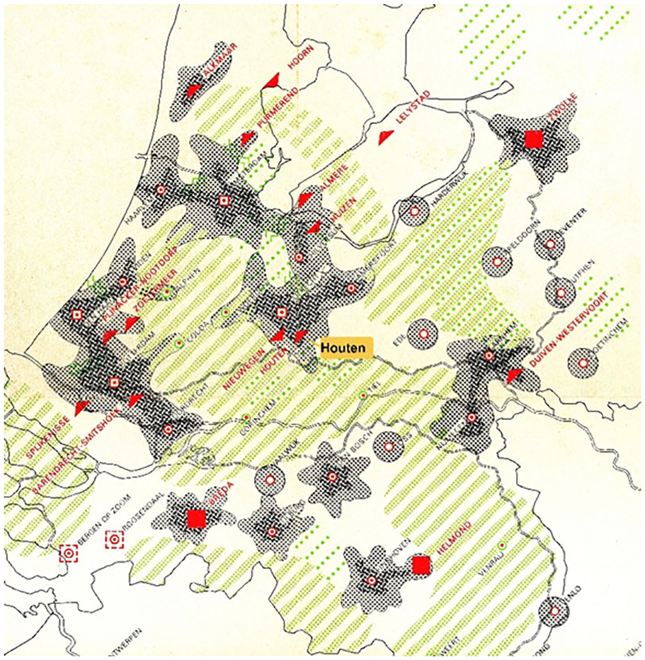
Third Memorandum on Spatial Planning (1978) prevented urban sprawl with Houten as rail-bound new town (map as a separate attachment at the Memorandum).
Bicycle-Friendly Planning through Proximity and Compact Cities, 1980-1990
Bicycle-friendly TOD cities were the outcome of a political struggle, and the railroads emerged from it as powerful national actor for at least two decades, nimbly maneuvering between local, provincial, and national governments. In the 1980s, the railroads abandoned their activist role, no doubt because by then TOD principles (densification and proximity) were embedded in the Third Memorandum on Spatial Planning. That said, neither the national government nor the railroads were authorized to carry out the recommendations. Moreover, the central government not only failed to fund the TOD planning it had formulated, but also continued to invest heavily in the country’s expanding highway network. It was left to the provinces to implement the policy without the requisite financial tools. 82 Funding for urban renewal was decentralized and used as co-financing with market parties. This arrangement gave cities new political leverage to change, accelerate, and improve land use. At the same time, decentralization allowed the country’s four largest cities to become a significant political factor in planning. In their new-found role, the four cities used the government project bureau’s research—in which the railroads had played such a major role—to develop the concept of proximity and compact cities, arguably supported by active local movements preserving historic cities. 83
The government’s fourth planning framework in 1990 reignited bicycle and public transit–friendly planning. The country’s first National Environmental Policy Plan—inspired by the UN Brundtland report—coincided with a shift from a budget-cutting conservative to a more progressive government coalition. Controlling automobility became the new government’s policy—again. The Fourth Policy Document on Spatial Planning (1990) formulated the government’s mandate of controlling mobility growth as a spatial planning principle: proximity over accessibility. The government’s framework called for authorities to first explore building within city limits before focusing on the outskirts. New development outside the four major cities was only permitted if there were good public transit connections. 84 And mobility alternatives like cycling and public transit received an extra share of the national budget (Masterplan Bicycle and Rail 21).
The fourth national framework’s emphasis on proximity and urban densification led to bicycle-public transit interconnections. In 1990, the central government tasked the twenty-five urban regions in the Netherlands to create new housing developments close to cities in exchange for public transit funds. The central-local governmental agreements were concluded in VINEX covenants. Councils welcomed the VINEX agreements that stressed good bicycle accessibility. In 1990, for example, Utrecht declared that the city “wants homes within cycling distance,” a policy goal that resulted in the popular Leidse Rijn district and—after two decades—good cycling connections with the historic city. 85 The proximity policy involved repurposing neglected areas within cities. This resulted in new down-town locations for 38 percent of the half million new houses built between 1990 and 2005. 86 Amsterdam and Rotterdam transformed outdated industrial and harbor areas into high-quality residential neighborhoods close to their city centers. And project developers advanced good bicycle accessibility as their selling point. Eurowoningen promoted their KNSM island apartments with the slogan “a ten-minute cycle from Dam Square”—in the heart of Amsterdam (Figure 6). 87
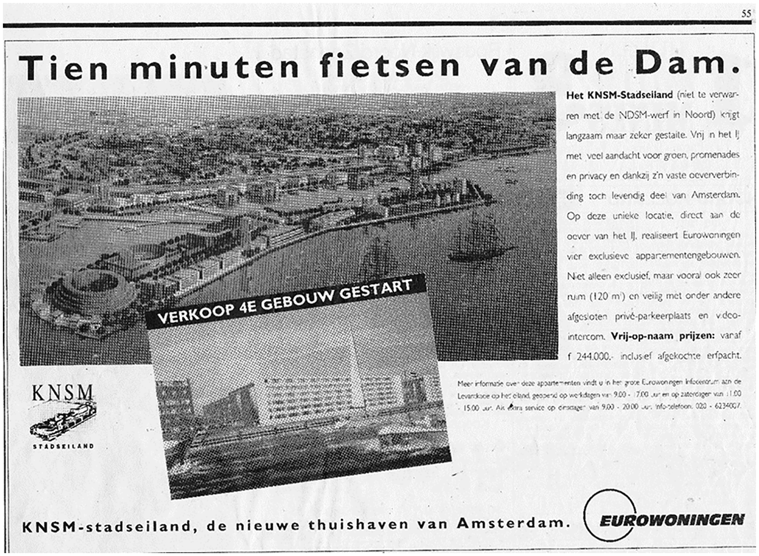
“A Ten-minute cycle from Dam Square.” Advertisement for apartments in Amsterdam’s redeveloped harbor area (1992).
The Dutch railroads’ TOD lobby since the 1960s, along with government densification and proximity planning principles since the 1990s, reinforced fifteen-minute bicycle commuter cities everywhere. According to recent research by the Breda University of Applied Sciences (BUas), these principles have accomplished two-thirds (11.7 million) of Dutch citizens now living within a fifteen-minute bicycle ride of a station. 88 Reflecting on how the fourth document had come about, colleagues acknowledge that the railroads’ planners, initially belittled as unqualified “urban planners,” were the ones truly responsible for shaping Dutch spatial planning. 89
Conclusion
For over a century, the compact and walkable city with easy access to public transit and ongoing travel has been touted as the ideal way to keep cities livable and green. In the 1990s, Peter Calthorpe famously declared that a New Metropolis also prevents urban sprawl. 90 Aligning urban development to combine public transit with walking and cycling is still—and perhaps more than ever—the best model to address the many challenges of fast-growing cities. 91 European “finger” and belt cities kept densely populated areas livable with public transit, as alternative to American car-oriented urban development. Since then, U.S. interest in air quality has generated discussions about how to plan for better land use to generate more sustainable mobility. 92 According to Erik Ferguson, who assessed the American ISTEA (Intermodal Surface Transportation Efficiency Act) federal legislation enacted for non-car planning designs twenty years ago, the United States lacked the proper spatial tools to achieve TOD. 93 As this article argues, Dutch history, in particular, shows the importance of regulations combined with a central vision and spatial strategy for managing TOD. Long-term focus and use of a range of policy instruments explain success—an insight also demonstrated in Portland (Oregon), America’s most successful TOD region, where the regional government, Metro, has invested public funds in development projects through its TOD program. Station areas with a mix of strong real-estate market trends and transit-supportive built environments are targeted for proactive TOD planning and public-sector leveraging. 94 On the other hand, Greet De Block’s important study on nineteenth-century railroad construction in Belgium and on long-standing policy such as keeping the price of train tickets low shows how workers and factory owners could stay in the Flemish countryside rather than move to densely built hubs. 95 These cases illustrate the long-term effects of state policy on mobility. International TOD scholarship often focuses on macro-level policies such as high density and mixed land use around stations. Based on Dutch railroads’ long-term focus on the bicycle in TOD planning, it is worth noting that more fine-grained planning such as safe and attractive routes to a station, well-designed station areas, and efficient routing between parking areas and platforms further enhance the bicycle-train combination.
Yet, what is striking about the history of TOD is that cyclists seldom feature as transit feeders in such plans. Despite a broad-based consensus that cycling represents a powerful short-distance alternative, the half-mile walking distance continues to define development around public transit terminals. 96 This is remarkable, to say the least. International observers never cease to be fascinated by the ever-increasing bicycle parking facilities at Dutch train stations, calling the spectacle “Cycle parking porn” and “fantástico.” 97 As we have argued, this is neither a coincidence nor a natural phenomenon. Bicycle-friendly TOD cities are the outcome of a political struggle. From it, the railroads emerged as powerful actor for at least two decades (1960s-1980s) before central and local government took up the idea in their densification and proximity principles (since the 1990s).
Examining Dutch urban planning history shows how the foundations for the bicycle evolving as before-and-after vehicle for train journeys were already laid in the early 1950s—before Spatial Plans identified the bicycle’s important role in preventing urban sprawl and keeping cities compact a decade later. Early on, Randstad planners helped to strengthen the linear Randstad urban areas as planning model while preserving the green interstices and producing transport-oriented and linear cities we still see today in the Netherlands. It has reinforced compact cities with good public transit connections and anchored urban planning policy principles for the future.
The Dutch government’s long-term involvement lent TOD a supra-local character from the start. The national railroads played a crucial role between 1960 and 1980, convincing cities that TOD combined with a robust train system was the answer to the pitfalls of automobility. Their lobby also succeeded because implementing and extending the national policy framework fell to the provincial authorities. Initially, the railroads’ urban planning lobby was sarcastically dismissed as “railroad planning.” Only later did the railroads’ strategists win the respect of their planning peers. In 1981, initial rival Hendrik Goudappel, founder of a prominent Dutch consultancy and professor of urbanism at Eindhoven University of Technology, confessed, “I still applaud the fact that the NS [Dutch railroads] plunged into planning in the 1960s.” 98
Even after the 1980s, when the railroads were no longer actively involved in government spatial planning, cities embraced TOD thinking, adopting this lobby for compact urban developments to prevent the white and middle-class flight to the suburbs. Most importantly—and not coincidentally—spatial restructuring took place within a fifteen-minute cycling distance of stations. Central government funds have helped reinforce people’s practice of cycling to the station by expanding bicycle parking facilities near stations since 2000. Cyclists benefited from the enlarged catchment area thanks to an effective TOD policy in Dutch urban areas. The policies have allowed Dutch cycling commuters to put into practice the fifteen-minute city—recently introduced in Paris—for decades already. 99
Footnotes
Declaration of Conflicting Interests
The author(s) declared no potential conflicts of interest with respect to the research, authorship, and/or publication of this article.
Funding
The author(s) received no financial support for the research, authorship, and/or publication of this article.