
Abstract
This article argues that medieval urban authorities developed nodal spatial strategies to mitigate various risks—from accidents, floods, and military vulnerability to sickness and scarcity. Using digital methods (Geographic Information System [GIS]) to map public works during the fourteenth and fifteenth centuries in one large city (Ghent), it offers a fuller understanding of urban governance in dialogue with a city’s topography and environmental and sociopolitical challenges. Ghent’s authorities invested in gates, bridges, markets, thoroughfares, key buildings, and waterworks. Tracing their interventions reveals the city as an interconnected, moving system, an economy of movement. Attention concentrated on these points because several types of interests related to communal well-being converged there. The city was thus capable of absorbing shocks (war, floods) through regular maintenance and monitoring. Tracing public works that promoted mobility can therefore tell us much about power dynamics and how communities functioned in practice.
In July 1431, Ghent’s aldermen decreed the start of the repair of an important thoroughfare. This had to be done, the ordinance stated, because its abominable state “put in dire jeopardy the common good of the city,” and “food traders were discouraged to attend [Ghent] with their wares.” 1 The city ordered a group of workers to divert the road in those places that were deemed beyond repair. However, anticipating major tensions with local residents, the magistrates warned the latter not to harm the workers. 2 The example offers a glimpse into the complexity of carrying out municipal public works, defined here as all building and material interventions funded by a city government. As is well known among urban historians, investing and intervening in the built environment offered local governments a way to expand their presence and authority, beyond improving communities’ well-being. Comparable efforts can be found throughout the premodern period and until the present day, as attested by anything from Roman road building, Islamic waterworks, Autobahns in Weimar Germany, or European Union (EU) infrastructural subsidy programs. 3 Public works are therefore also a particularly direct reflection of the (historically specific) ideas governing institutions had about their economies, indeed what a society or community needed, in a very practical and material sense, to thrive.
Public works can be found in the first extant administrations of European cities, which begin in the later thirteenth century. 4 The semi-independent towns in the Low Countries seem to have been particularly precise in documenting all such expenses, and are therefore studied extensively. 5 These studies are part of a by now well-established historiography on the spatial and material development of medieval cities. 6 However, there are two key lacunae in this research field: a lack of interest in the spatial logic of investments and subsequently in maps and spatial reconstructions, and a lack of focus on routine infrastructures and amendments. Instead, new and/or large constructions have received the bulk of attention. Current scholarship, on the Low Countries and other western-European regions, has mainly focused on the larger, prestigious municipal buildings such as town halls, or on fortifications, as ways of establishing and legitimizing political authority through public works. This has marginalized infrastructural amendments and smaller projects such as repairing a modest bridge or paving a common street. Historians tend to explain the nature of such routine investments simply by noting that they were “necessary,” and that diversity in expenses changed according to that necessity. 7 However, mapping and analyzing such interventions, which often targeted a variety of spaces, offers fuller understanding of public works’ history and goals. These were in dialogue with a city’s topography, environmental changes and other challenges, including material constraints. It is this goal of studying a city as an interconnected, moving system though tracing the impact of public works that the present article pursues. We have chosen to focus on Ghent, one of the largest cities of north-west Europe in the later Middle Ages. Yet our approach of analyzing public infrastructural works in their specific environmental and sociopolitical contexts using digital spatial (Geographic Information System [GIS]) analysis offers a model that can be applied to other cities—and periods. 8
Our main argument is that medieval urban authorities developed what we call “nodal” spatial strategies to control the city and residents’ well-being, straddling economy, safety, and health interests. They made systematic investments in infrastructures, with a special attention to nodes, because, in Ghent, which had a complex canal network, this helped to minimize various impediments and thus reduce risks—from accidents, floods, and military vulnerability to sickness and scarcity. Public works stimulated movement and the control over the flows of goods, matter, and people through the city. Put differently, they made urban society more resilient and able to absorb or adapt to shocks, not merely by ad hoc reactions to crises, but especially by extending control over spatial nodes or bottlenecks. This also ties in with recent calls in the field of historical disaster studies to move away from an “event-based focus” and look at the role of general institutions (in this case urban government) in determining the impact of hazards. 9 Municipal interventions reflected political ambitions and claims over space, but also a high awareness of how environmental challenges and opportunities could be addressed by making material changes and by routine maintenance. Public works were therefore tied together in what we dub an “economy of movement,” which was key to controlling a city.
How can we find the coherence in routine public infrastructural works, and reflect on their function? It is important not to prioritize one specific interest (economic, military) but to trace how all such interest converged within specific nodes. The key insight here is, we argue, that public works facilitated mobility. This was important to secure social, political, and economic capital, to preserve energy in its broadest sense (in terms of food, fuel, and labor used in the city), and promote historically specific notions of safety, health, wealth, morality, and order. 10 Thinking about a city as an “economy of movement” or “motion economy” offers new insights into what we may call sites’ urban logic: what it meant, in a practical but also in a more symbolic or performative way, for certain things to be in certain places. An emphasis on movement foregrounds not only smooth flow or blockage, but also moments of friction, and we will argue that maintaining mobility was a key tool in the structural response to risks. 11 Thus, the economic, sociopolitical, and cultural implications of movement at the urban level connects to the study of mobilities. This transdisciplinary research field emphasizes the importance and “empirical facts” of mobility, and is most prevalent in the social sciences and (historical) geography. Furthermore, these scholars share an interest with the neighboring research field of actor-network theories (ANT) in humans and technologies as tied together in “systems.” 12 Mobility scholars are broadly interested in the convergence of abstract (cultural) and physical mobilities, but are usually less focused on material infrastructures. 13 Especially, studies on premodern infrastructures are few and far between, as scholars of premodern cities also rarely actively engage with the conceptual frameworks on mobility developed by social scientists. 14
There is much to be gained, however, when such theories are confronted with the ideas that medieval authorities and inhabitants may have had about the connections between urban physical, political, and economic order, which differed from contemporary Western theories. First, local government elite’s motivation to intervene in public space went beyond their immediate self-interests, as further discussed below. Second, at the basis of the medieval urban economy of movement lay a political economy shaped by an organic notion of community. This, however, was much more complex than a flat and static hierarchy. Mobility and flow were perceived as constitutive for the health of individual bodies, but also of natural environments and social bodies. 15 The urban economy of movement was informed by the idea of the city as an organism, which needed, like a human or animal body, a dynamic moving balance to flourish. To give two brief examples, in 1488, Ghent’s authorities ordered the cleaning of road gutters to “prevent the great dangers stemming from the dirt [. . .] lying in the streets.” 16 The danger referred to here was that refuse accumulated in clogged gutters, which bad odors corrupted the air and caused disease. In an earlier publicly proclaimed decree, the magistrates lamented the “major damage and nuisance” to the city caused by officials controlling the weirs who had neglected their duty to flush the water and urged them to better their ways. 17 In short, thinking about well-being in terms of movement likely influenced the strategies behind public works.
The following sections first outline our case study and sources. Ghent’s magistrates systematically accounted for public works and street paving in their administration of income and expenses (stadsrekeningen, extant in a nearly complete series from the 1320s onward). In addition, the issued ordinances (Voorgeboden) and payments for policing officials give further insights into the intended function of public works investments. These data can be brought together and mapped using a GIS. We then proceed to describe the key elements of an urban economy of movement: what were the nodes at focus and why? And how did various goals of protecting well-being converge in specific urban spaces? We then move on to explore how Ghent’s government used public works to counter threats, most notably floods and war. Finally, having learned about the basic functioning of the economy of movement, we zoom in on its agents and whose interests, in particular, were served by investing in it.
The Development of Ghent and Its Competing Stakeholders
The city of Ghent developed from the tenth century on at a strategic site, a large sandy hill between two intersecting rivers: the Leie and the Schelde. 18 It benefited from this position for trade, as well as from the presence of two major abbeys and a fortified residence of the Count of Flanders. As in many other towns during the later Middle Ages, building progressively moved toward the waters, as the waterways became more and more attractive and sometimes essential in terms of sustaining a growing urban population and local economy. 19 By the early fourteenth century, Ghent was a major hub with approximately 60,000 inhabitants. 20 The start of documentation in the 1320s also means that we fall right into a functioning system: several man-made waterways, dams, and sluices, including a canal connecting to the harbor of the town Damme (the Lievekanaal), had been constructed in the two preceding centuries. Likewise, many of the main market squares, such as the Vrijdagmarkt, the Korenmarkt, and the Plaetse, and some of the fortifications, were already in place (Figure 1). 21
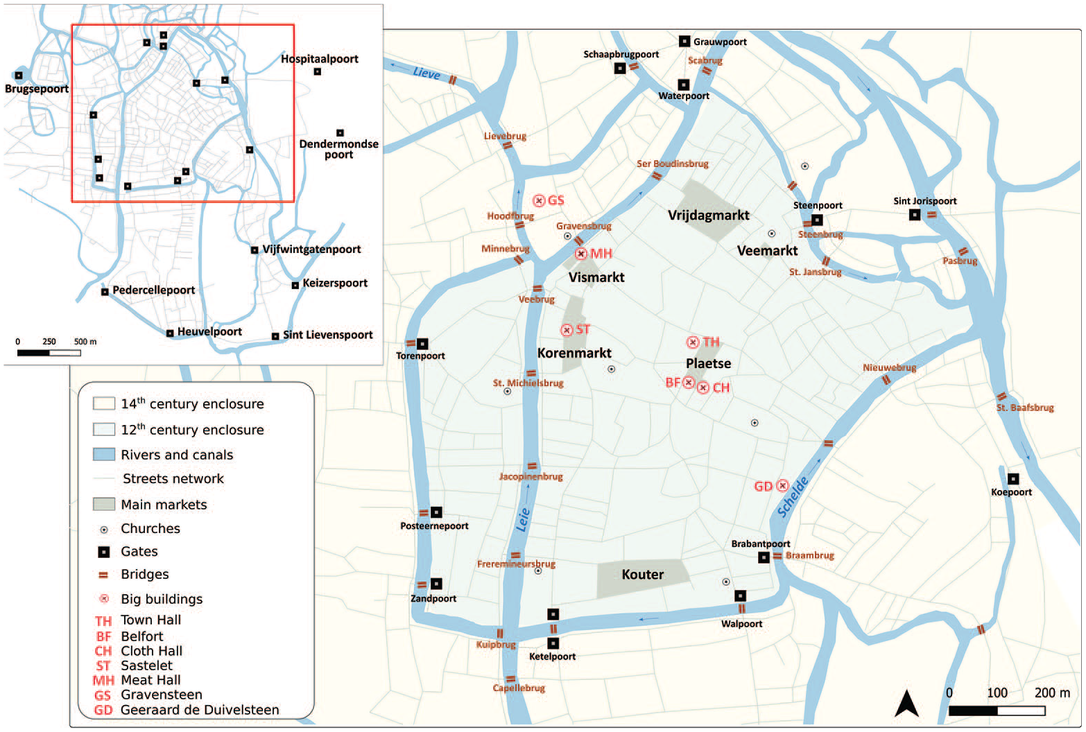
Ghent’s topography.
Since the fourteenth century, the city’s government consisted of two colleges of aldermen, each with their own courts and competences, in which various artisanal collectives secured the privilege to annually elect representatives. 22 Regarding the decision-making about public works expenditures, the six crafts comprising the building sector were guaranteed a seat in the aldermen’s college, meaning that there was always one alderman directly acting in their interest. Of these six crafts, two, the masons and carpenters, monopolized that seat. 23 Furthermore, city-appointed surveyors (erfscheiders, elected each year, always a master mason and a master carpenter) were the linchpin in all municipal building activity. 24 These officials pushed for large projects (they received extra payments for them), but also performed more routine inspections, including rulings in conflicts between citizens, and likely often advised the aldermen on what was needed in the city. 25
Although the ideology of the common good and the city as a normative community were important, neither this government nor the public works it commissioned were driven by a proto-democratic ideal of wellbeing in relation to equal access to (public) resources. Instead, the urban political organization entailed a complex and ongoing negotiation between different social groups or stakeholders, each acting to secure their interests, in which both vertical and horizontal ties were important. 26 Municipal investments in building did not merely serve the (personal) interests of the ruling elites, but included broader (corporate) interests, as John Najemy recently argued with regard to Florence. 27 Indeed, squares, gates, and bridges targeted by city investments were also crucial places for the trade of the goods that the guilds, represented by aldermen in city colleges, produced. Urban authorities’ strategic nodal investments in public works and infrastructures reflect an awareness of the complexity of movements and flows within the city in relation to communal well-being, and a clear interest to influence these dynamics. They also understood the power than could be gained with control over nodal points.
There were four general types of rivalry between social groups that influenced the city’s economy of movement. First, the urban government ruled largely independent from the Count of Flanders and later Dukes of Burgundy. At the same time, continuous conflicts with these seignorial overlords, and with other Flemish cities, had a profound influence on urban governance, on thinking about how a city could be best designed to thrive in competition with these other political entities. Second, at the level of urban governing elites, the city’s nobility competed with merchants and artisans over political dominance. Furthermore, there were strong rivalries between guilds, such as over which work activities and trades belonged to which group, and, finally, between guilds and artisans or workers not organized in formally acknowledged collectives. 28
Thus, the urban economy of movement consisted of many different (groups of) agents, of which the urban authorities were merely one important player, who negotiated acts (micro)resistance, re-use, manipulation by other social groups. Some of such tactics are visible in the municipal records. For instance, groups of neighbors or religious institutions negotiated their contributions to infrastructures, and also influenced public works. 29 We will return to the potential benefits of public works for these various social groups at the end, yet now we first focus on the public works, as municipal strategies.
Method and Sources
Ghent’s public works were mainly financed by three types of revenue. First, taxes were one important source, such as one levied on carters from outside town for paving. Some works were funded by a special allocation, such as a tax on grain to pay for the Great Meat Hall. Second, fines were invested in building. 30 Other parties that had a direct interest in the works also regularly contributed, such as guilds paying for their halls or markets, or neighbors to repair streets, wells, or nearby bridges. Religious institutions, too, at times contributed, especially the two large abbeys, St. Baefs and St. Pieters. 31
Public works were systematically registered in the city’s accounts (stadsrekeningen), in which the aldermen noted both new projects and routine repairs. 32 During the fourteenth century, public works comprised, on average, 12 percent of the total expenses of the city, with peaks up to 27 percent. The level of investment likewise fluctuated strongly in the next century, and between 1400 and 1460, the public works comprised, on average, 14 percent of the total of municipal expenses. 33 As an economic sector, and compared to the total expenses of the city, public works were small, and even during major building campaigns, the city employed only a fraction of local workmen and laborers. 34 Yet this makes it all the more striking how efficient the authorities tried to be in their investments and interventions to enable movement.
In order to explore the spatial logics of public investments, we mapped all the expenses incurred by the city government for twenty-three sample years, namely thirteen years in the fourteenth century and ten sample years in the first half of the fifteenth century. Collecting all described expenses of the sample years, this yielded a total number of 830 expenses with a specific location for the fourteenth century and 1863 for the fifteenth century. 35 The difference in number has mainly to do with changes in recordkeeping. In the early fifteenth century, the city began listing public works per month (with thirteen months per year of account), which means that activities lasting multiple months appear several times in the register. We chose a combination of years with high, average, and low total expenses of the authorities (Chart 1).
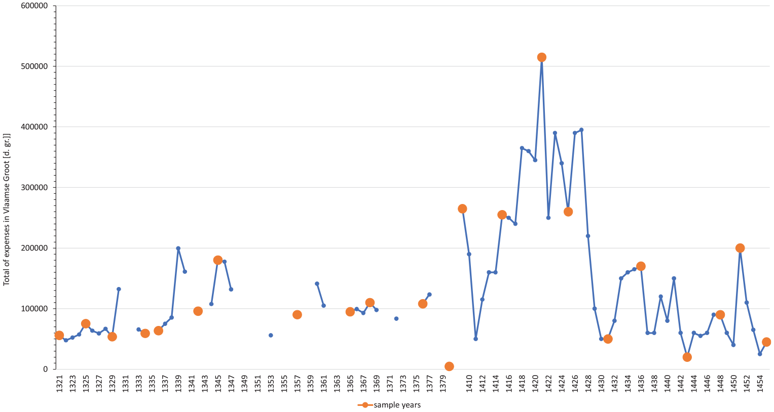
Total expenses made by Ghent’s aldermen (in Vlaamse Groot [d. gr.] 36 ) per years, and choice of sample years.
During the fourteenth century, the average spent on public works per year was 68.635 Vlaamse groten (hereafter: d.gr.) To give an impression how much this was: it represents the yearly wages of fifty-seven skilled workers, or about 13.691 day wages when counting 5 d.gr. per day. This sum was much lower than the sum spent on public works during the fifteenth century, which was 139.331 d.gr, but still comparable given the inflation of the currency and rise in wages. 37
Linking the database to GIS, we can visualize the spatial distribution of public works expenses. The locations in question can be visualized in two ways: as a “line” (such as a street, river, canal, road) or “point” (such as bridge, marketplace, gate). We therefore adapted our mapping model by using lines or points, in order to stay as close as possible to the experience or perception of space that this use of specific landmarks reflects.
Public works expenses were increasingly located in the sources by specific points within the city. 38 Figure 2 shows the frequency of the works at specific locations. The bigger the point, or the thicker the line, the higher the number of years for which we found at least one intervention in a certain location. For instance, if the value for a point is between 50 and 80 percent, that means that the city worked on this location during 50 to 80 percent of the total of our sample years. Therefore, when the frequency of work on a certain location is high, the city invested regularly. 39 We can identify in Figure 2 three major areas of interest, with particularly frequent activities: the surroundings of the Korenmarkt, the Plaetse, and around the Brabantpoort. This concentration reflects how important yet vulnerable the daily flow’s management might have been there, and that those areas were crucial nodes within Ghent’s economy of movement.
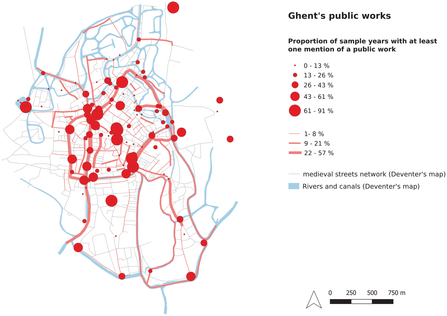
Public works investments in Ghent during the thirteenth and the fourteenth centuries (twenty-three sample years).
The Nodal Strategy
Ghent’s aldermen invested much and with great regularity in specific spatial bottlenecks. There were five types of bottlenecks or “nodes” that keep recurring in the sources, namely buildings, gates, waterworks, bridges, and, finally, market squares and the major thoroughfares connecting them. We will briefly discuss each of these. First, a large part of investments was dedicated to buildings (21 percent of the total number of entries). The city mainly focused on two aldermen’s halls (Schepenhuizen; Ghent did not have a unified town hall until the early sixteenth century), 40 a cloth hall, belfry (Belfort), and a prison (Sastelet). They also built and maintained two meat halls. 41
Gates accounted for 16 percent of the total number of recorded expenses. These constructions varied from a modest arch to elaborate fortified buildings, such as the Torenpoort, Posteernepoort, and Pedercellenpoort. By the fifteenth century, over twenty gates dotted the city (Figure 1). 42 These constructions served multiple interests, of monitoring flows of people moving in- and outside town, while economic aims were also guaranteed by using the gates as checkpoints for merchandise. In addition, doors and drawbridges served military interests. Related to these combined goals were more symbolic aspects of representing community, and thus of urban honor and prestige. Since Ghent lacked a full ring of city walls (according to Hans Van Werveke due to financial deficits), gates were positioned strategically on the city’s main entrance points, often at a conjunction with waterways (Figure 1). 43
Although the magistrates invested overall larger sums in buildings and gates, they invested more regularly in waterworks (22 percent of the total entries). Waterworks are defined here as all infrastructures used to keep the water in place, to manipulate the current and water level, and generate access to water, including fresh water and hydropower for industrial and waste-removal purposes. The city’s waterscape was subject to intense manipulations from at least the twelfth century onward. Water was led through the city in a variety of man-made canals and natural streams. Its collective flow could be halted and stimulated through a system of more than a dozen dams and sluices. 44 This water system, with its routes both outside and through the city, was built before the extant accounting of public works, leaving us in the dark about the costs of its initial construction, which must have been substantial. However, its routine maintenance is clearly reflected in the extant records, such as by maintaining dams, lining quays with wood or stones, dredging, clearing slopes, or cutting away vegetation (statboemen). Also, occasionally condutes, which were various types of drains and sewage, were mentioned to channel water. 45 Another construction regularly popping up in the records are piers (steigers), while a large crane for unloading ships—a key tool in the flow of goods from one type of transport to another—was likewise subjected to both routine maintenance and inspections. 46 Collectively, the waterworks created several crucial “tools” to control movement within the city. 47
The vast water network meant that many bridges served as key connectors between roads and between different parts of the city. They are a recurring point of investment (16 percent of the total amount of accounted entries). The roads crossing these bridges needed to be regularly repaired, as did the structure of the bridge itself. Moreover, several bridges also had a city gate on it or in its direct vicinity.
In order to ensure circulation between central nodes, urban authorities regularly paid for paving and repairs on the streets network. Figure 3 shows the spatial distribution of the latter. We can see that roads along rivers, those which lead to the city (Steendam, Brabantdam) as well as the ones that connect important nodes (the Veldstraat connecting the Ketelpoort to the Korenmarkt, or the Donkersteeg connecting the Plaetse to the Korenmarkt), are often subject of investments. Moreover, the Muide, the far northern border of the city, was an important entrance point into the city but a swampy area, which required many paving expenses.
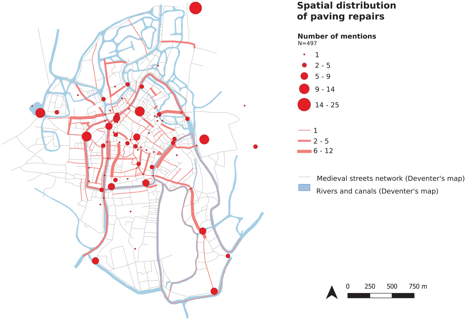
Spatial distribution of paving expenses during the thirteenth and the fourteenth centuries (twenty-three sample years).
The numerous bridges in their direct vicinity are frequently repaired, reflecting the great impact of the mass of pedestrians and vehicles daily using them on the state of the roads at these bottlenecks. The city government invested in marketplaces (11 percent of the total amount of accounting entries), both in paving and other infrastructural activities. They spent often and considerable amounts on the region of the Korenmarkt and Vismarkt, located strategically near the harbors and waterways but also vulnerable to deterioration of infrastructure and flooding. The Plaetse square, home to the belfry, cloth hall, and the Scherpenhuizen, was located higher up on the hill and faced no risk of flooding. This area was perhaps also less likely to have been congested, and the surroundings of the Plaetse have relatively few investments.
While the nodes just described all appear regularly in the accounts, the aldermen’s investments pattern changed through time (see Chart 2). Due to the construction of a new Great Meat Hall (Groot Vleeshuis, 1408-1414) and the Cloth Hall (Lakenhal, 1420s, but remained unfinished), costs peaked in the early fifteenth century. 48 Waterworks remained crucial for the city, in terms of work frequency, even if the city ordered more work during the fourteenth century (25 percent) than during the fifteenth century. The magistrates devoted less work to the city’s bridges during the fifteenth century than during the fourteenth century. Indeed, the major and costly transformation from wooden bridges to stone constructions was made in the latter. Likewise, large-scale paving activities also happened relatively early. 49 By contrast, on the gates, the city ordered much more works during the fifteenth century. This likely related to increasing tensions between Ghent and other regional powers (see below).
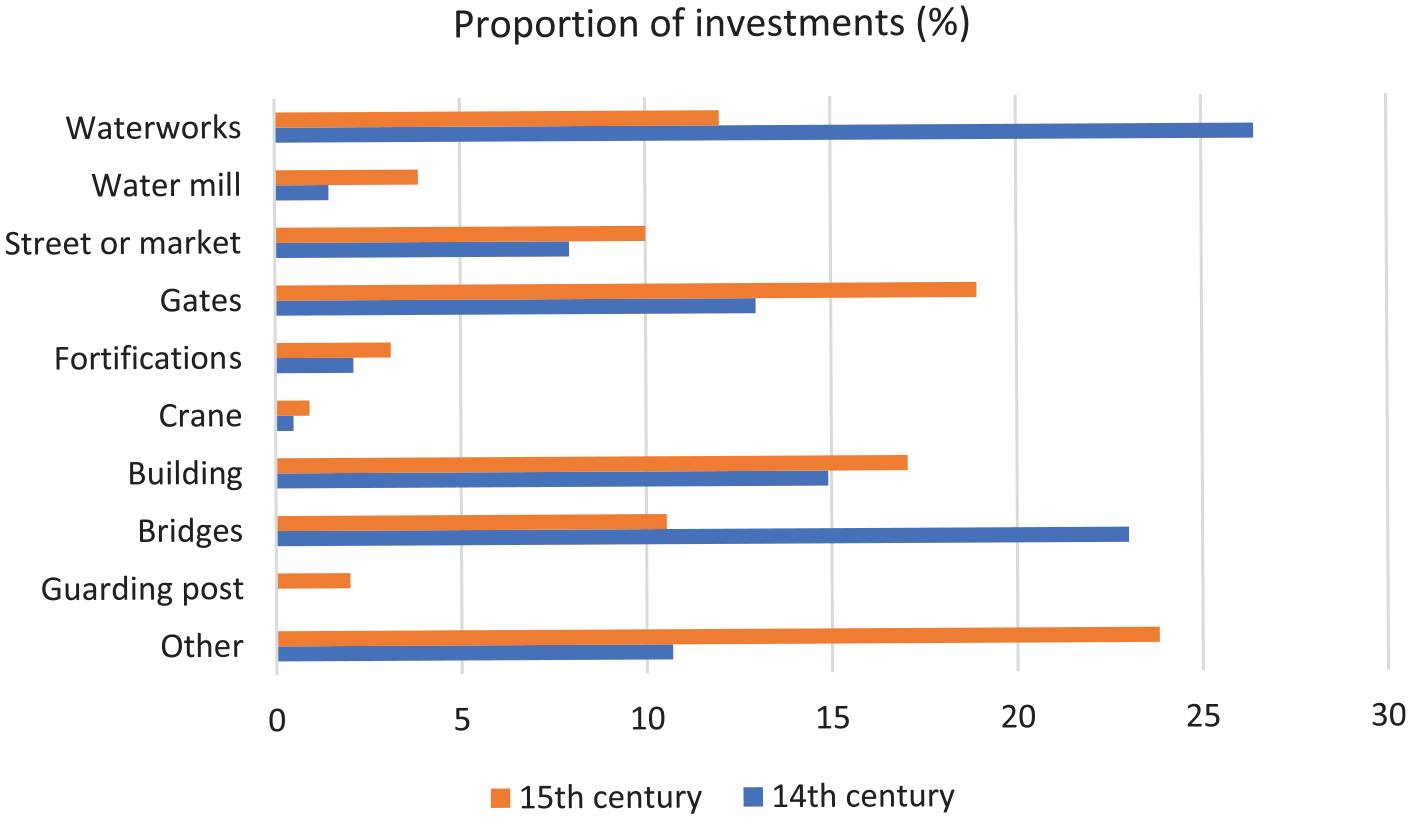
Proportion of investments (number of account entries), for the fourteenth and fifteenth centuries.
The economy of movement did involve not only investments, but also regulations. Key examples are many ordinances issued on the correct use of infrastructure, sanitary measures, and rules on the right conduct of commercial activities, especially those around food. 50 Rules prevented breakdowns and blockages of various kinds (such as multiple bans on speeding carts or trotting horses, which could damage the pavement and make it less useable), 51 but also shaped who was entitled to use certain spaces—and who was excluded. For example, the Gravensbrug, around the corner from the meat hall and fish market, doubled as a market, with very precise designated sale locations on and around it for fruits, vegetables, eggs, and dairy. 52 These were in line with detailed inspection and registration who was allowed to sell fish and meat—and during which times of the day. 53 Spatial prescriptions also extended to moral and even sexual conduct. For instance, in 1349, the aldermen ordained that no prostitutes should wander on the Plaetse (near the town and cloth halls) after sunset, or near the Veebrug (leading to the meat and fish markets), under the penalty of losing their overgarments. 54
The city installed several policing officials to enforce all these prescriptions. 55 In many cases, those having a role in the execution of public works also had competences to police and inspect these spaces, report abuse, and prosecute offenders. The two city surveyors (erfscheiders) managed public works, and the paving master (kelsiedemeester) oversaw paving activities. An official called the coninc der ribauden headed a brigade that transported building materials, did much of the cleaning, digging, and various other kinds of menial work—including military tasks. During the fourteenth century, they were paid to clean and supervise a specific set of spaces, which were by and large the very same nodes central in public works. 56 Furthermore, each year the coninc and surveyors “went around with the hammer” and either checked or demolished (fire)hazardous constructions. 57
To conclude, the differences in types of investments illustrate that each node had a different function within an economy of movement. The mix of investments and interventions varied per site determined by function, position within the city, and its proximity to harbors and water. It suggests that authorities perceived the city as a network of nodes that required financial investments and regulations to flourish—nodes that would be hard to detect without a digital spatial analysis. Besides these nodes, not much attention, either in terms of investment or regulation, was paid to the rest of the city.
Promoting the Common Good: Trade, Military Safety, and Sanitation
Municipal nodal strategies made sense because they targeted a convergence of diverse interests. As Ghent’s authorities themselves at times emphasized, the overarching goal of these activities was to promote “the common good” (ghemeen oirbair). 58 A close look at public works uncovers that this pursuit of communal well-being can be divided into three key aims, namely trade and supply (of water, food, and fuel); military safety; and health and sanitation. Furthermore, the political goal of promoting urban honor and prestige was an important additional motivation, especially within the competitive Netherlandish urban network. Perhaps with the exception of sanitation, these goals would surprise few medieval historians. However, what is rarely noted is that in practice they converged around the same spaces or nodes, which we will now move on to discuss for each of these aims.
To start with commerce and trade, investments in waterworks, for instance, helped to ensure the water level was high enough for ships to reach the harbor. The so-called sluice masters coordinated the flows on a more daily basis, and taxed shiploads. 59 Furthermore, all wares had to be transferred to ships owned by Ghent’s free shipmen (vrije schippers) to be transported through the city. This group of inhabitants thus capitalized on movement, and had key interests in creating a hydro-infrastructural system that ensured its functioning in practice. 60 The water system and concerns about supply reached far beyond the city, as reflected by Ghent’s major efforts to build and retain its own canal to the sea. 61 The aldermen also on various occasions complained that the recipients of the toll offices, such as the sluice masters, did not do enough to maintain the waterways under their supervision. 62
Transport over water was much cheaper and faster than any overland alternative—this was true for basically any pre-industrial society. 63 However, the repairs of roads under and around gates, of entrance roads, and the paving of new roads in the outskirts of the city demonstrate that overland traffic and trade, including import of building materials, was also important and sustained by public works. 64
The commercial halls and centralized marketplaces ensured monopolies and privileges of sale, as all trade was ordained to take place there. This also meant that the flows of people and goods had to be facilitated. The grain trade, revolving around the Korenmarkt, is the most striking example. After 1350, Ghent succeeded in formally securing the staple right for grain. All wheat and rye from France transported along the Leie and Schelde had to be offered for sale on the Korenmarkt. Most importantly, the city could reserve a part, commonly one-fourth of the total amount passing through the city’s market, as “designated grain” (onvrij graan), allocated for consumption by Ghent’s citizens, and thus forbidden to export after purchase. The stapelheren, three prestigious officials, were in charge of enforcement. They also sampled the shiploads upon arrival and checked the grain’s quality before ordaining obligatory storage. 65 They were thus continuously physically present at the Korenmarkt. The large number of ordinances on the subject suggests that this grain system, as a part of public health governance, was highly adaptable to fluctuations and required extensive enforcement to uphold. The spatial centralization and infrastructure around it had to guarantee that this system functioned well on a daily basis. 66 Thus, it explains why we find the Korenmarkt as an intensively amended and supervised space: cleaned by the conincxkinderen in the second half of the fourteenth century, and a major object of paving investment. 67
Moving to the second key aim, that of military safety; many of the practices described above were in some way connected to military interests and concerns about public safety. Like other larger cities in the later medieval Low Countries, Ghent was an important player in regional politics, and engaged in multiple military conflicts during the fourteenth and fifteenth centuries. 68 Ghent’s political-military history has received ample attention, yet that attention is rarely focused on material responses within the city. It therefore merits emphasis here how much of the urban military effort was based on a nodal spatial strategy. As noted above, much was spent on gates. Instead of a full encirclement of city walls, the very same system of controlling waterways also served as a military protection. From the thirteenth century on, the city’s control over the water levels enabled them to inundate several marshy areas in its direct vicinity in case of approaching enemies. 69 This combined use (for trade, to prevent flooding, to create flooding as a safety measure) explains why the city government invested so much in techniques to control the urban waterscape.
Furthermore, well-functioning infrastructures and open spaces were also important because they facilitated a quick response in case of spreading fires or approaching enemies (who also routinely used fire as a weapon). Easy access to water over paved roads and to piers and quays was important for the same reasons. 70 Road paving, solid bridges and fortified gates enabled quick transport of war equipment. Building officials such as the surveyors, road masters, and conincxkinderen were therefore also working with military interests in mind. 71 Finally, large buildings played a role, too: the bell tower (Belfort) on the Plaetse had the banclock, which was tolled in case of military emergencies or to announce military expeditions (herevard). Also, for fire safety the aldermen’s hall was a central place: over a hundred buckets were kept in its basement, which were distributed by officials to inhabitants in case of fire. 72
Third, the need to be able to close off the city in various ways could be diametrically opposed to the wish to promote flows, because the latter were key instruments to promote urban sanitation and therefore public health. 73 Medieval medical theories construed humans as prone to contracting illnesses through exposure to air corrupted by polluted waters and land, excrement and refuse, by ill human and animal bodies, or by consuming spoiled food. 74 Each of these health risks were mitigated by a nodal spatial strategy. Public works helped the centralization and inspection of two perishable foodstuffs (raw meat and fish), and the most important one in terms of sustaining the caloric intake of a population: grain. Furthermore, the prevention of corruption in miasmatic terms by avoiding pollution and the accumulation of filth was attested by a large number of ordinances, as well as by the installment of cleaner-supervisors in key nodes, as noted above. Sanitary ordinances often generally targeted “the streets of the city,” yet if they were more specific, they mainly tried to ban filth from marketplaces, the Plaetse and the Korenmarkt. 75 These prohibitions to discard waste are moreover part of many more zoning prescriptions and the avoidance of traffic congestion. 76
In Ghent, as in many other water-rich northern-European cities, concerns about polluted water were abundant in regulations, and its solution lay especially in maintaining flow. While rivers were a major circulation axis and helped to transport waste (waters) out of town, they were also seen as potential vectors of illness. The idea that smooth flow and clean waterways promoted health is clearly present: reflected by many ordinances banning the disposal of certain types of filth in the rivers. 77 Moreover, the magistrates combined such bans with regular calls to inhabitants to clean the streets, quays, and waterways surrounding their private properties. 78 Maintaining the flow of surface waters was all the more important because inhabitants were likely using them for consumption and artisanal processes. This is indicated by the low number of building activities devoted to creating separate systems supplying fresh water, especially for such a large city as Ghent. 79 Although evidence remains scarce, the flushing of waters likely happened regularly, perhaps even weekly. Furthermore, periodical large-scale cleaning operations took place on several occasions. 80 Finally, the use of the water canal system for consumption was also reflected by the regularly returning expenses for the upkeep of animal drinking spots (gewaden), often near bridges. 81 And while sanitary regulations applied to the city as a whole, the municipal nodal strategy again converged around key intersections of rivers, on places where weirs and other waterworks were built, and on busy commercial areas and markets near the water.
Zooming in: The Brabantpoort Complex and the Kuipgat Complex
To recap, the city invested regularly in specific nodal points, on which it depended for trade, supply, military safety, and sanitation. Two case studies demonstrate the spatial concentration of interests. The first is what we will refer to as the Brabantpoort complex. Located at the south-east border of the medieval city (see Figure 4), the oldest part of this complex was probably the Brabantdam. Constructed between 1150 and 1199, 82 this dam was built over three existing waterways and along the Old Schelde. Besides providing pedestrians and vehicles coming from and going to the region of Brussels and Aalst with a dry path through the marshy lands, the dam enabled to control the level of water in the Schelde to ensure the navigability of its course upstream.
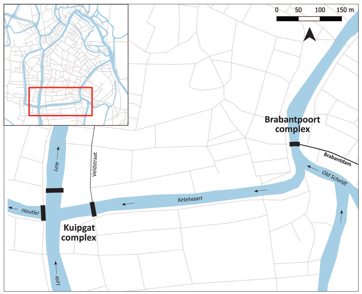
Location of the “Brabantpoort complex” and the “Kuipgat complex.”
The Brabantpoort (the Brabant gate), was built by the end of the twelfth century. Opening on the Brabant Bridge (Braambrug), which came over the Schelde, the gate was a point of tax collection, but also a place of strategic defense. Between 1254 and 1270, Ghent’s inhabitants built a weir called Braamgaten beside the Braambrug. This weir allowed to regulate the level of water and circulation, but also to force the ships coming from the South to continue in the direction of Ghent’s harbor on the Leie (Leieportus). This piece of hydrological engineering was also used to protect the city from major winter floods and from enemies’ attacks by inundating the city’s surroundings. 83 The weir also promoted public sanitation since it could be opened to release a large amount of water in order to flush the river from silted filth. Finally, in 1297, Ghent’s city government decided to set up its watermills directly downstream of this weir, in order to benefit from the rise of the water level. Therefore, at the beginning of the fourteenth century, the Brabantpoort complex was composed of a road, a bridge, a gate, a weir, and mills, all set up to ensure the control of different flows (Figure 5).
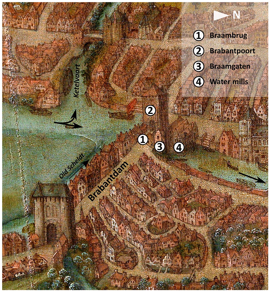
The Brabantpoort complex on the panoramic view of Ghent in 1534 (STAM Gent—www.artinflanders.be—Hugo Maertens—public domain).
The complex already functioned fully for a few decades when we first see it appearing in the municipal accounts. On the Brabantdam, the city government worked on the paving: in 1336, for instance, 383 d. gr. was spent to repair the road of the Brabantdam. 84 In 1321, the city asked nearby residents to clean the road. 85 Men are also regularly paid to work “on the gate” in order to improve it (“an de poorten van der stede te beterne”). 86 The precise nature of the work is not always clear, but when we do learn more, the range of tasks is wide: from masonry to carpentry and ironwork. 87 At the watermill, too, workers are paid to do some paving repairs, change grindstones, and more broadly the upkeep of the building. Expenses are also regularly made to maintain and improve the Braambrug. Finally, diverse crafts work also at the weir, notably to enable its opening in order to regulate the level of water. 88
The aldermen maintained the components of this complex with great regularity, namely in twenty-two of our twenty-three sample years. Chart 3 shows on which part of the complex the aldermen invest money each year: the Braambrug, the Braamgaten, and the water mill are subject to regular expenses, whereas less frequent repairs are done on the Brabantpoort and the Brabantdam. The difference can be explained by the fact that the first three components are in constant contact with water, which makes them more vulnerable.
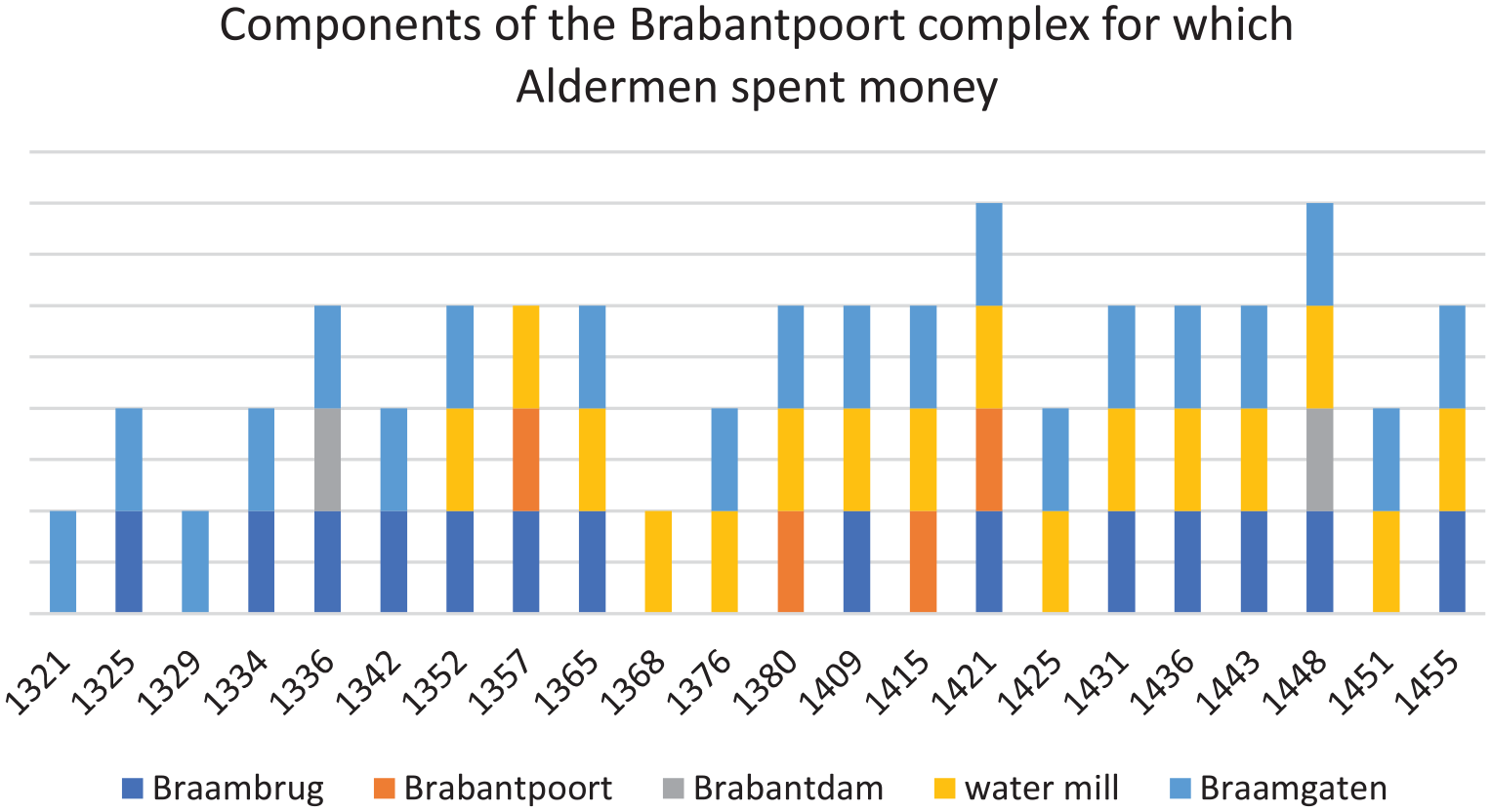
Components of “Brabantpoort complex” on which aldermen spent money.
Another crucial node for military safety, trade, and circulation was the Kuipgat complex. Located at the crossroads between the Old Leie and an artificial canal named the Ketelvaart (or Ketelvest), in the South-West (see Figure 4), this complex is highly strategic in many respects. The Ketelvest was dug between the Old Schelde and the Old Leie, probably at the end of the eleventh century, in order to protect the southern side of the city. It might have been a dry defense ditch in the first place. 89 The ditch was likely deepened during the second half of the twelfth century, after which it became a canal (the Ketelvaart) that ships were forced to use to reach the harbor on the Leie, 90 as explained earlier (Figure 1). Besides this defensive belt of moats, the aldermen ordered the construction of a series of gates during the second half of the twelfth century, which resulted in a fortified water gate at the meeting point of the Ketelvaart and the Houtlei, named the Kuipgat. Composed of a weir flanked by two towers, this watergate aimed to control the circulation of ships and the level of water, and to protect the city from the high waters. It also offered the possibility to flood the surrounding lower areas in case of external attack. As with the Braamgaten, this weir was also used to regularly flush the downstream part of the Leie. A few dozen meters to the east of the Kuipgat, the city government also built over the Ketelvaart a fortified bridge which led to the gate named Ketelpoort. This gate is the entrance to the road that comes from the south by going along the Leie and leads to the Veldstraat, one of the most frequently repaved streets within the city. 91 The Ketelpoort had therefore a key role to play in controlling the circulation of pedestrians and vehicles. The public works accounts disclose that there was also a weir under the bridge of the Ketelpoort, 92 again to control the level of water at the end of the Ketelvaart. Another bridge, apparently not fortified, located on the western side of the Kuipgat and named the Kuipbrug, gave access to the Houtlei. Together, these buildings and infrastructures constitute the Kuipgat complex as an important focal point of flows.
The high level of public works expenses confirms the significance of the complex: Ghent’s aldermen spent on at least one of the complex components in nineteen out of the twenty-three sample years. The type of investment is similar to those we described earlier for the Brabantpoort complex. Even if many expenses for this complex are lacking in detail, money is clearly spent to improve the two bridges and repair the road in their direct vicinity. Masons and carpenters are also paid to work on the weirs. The city worked on the Kuipgat complex in each of the samples years for the fourteenth century, and in six of the ten sampled years in the fifteenth century. Payments were highly regular for the bridges and the gate, and to a lesser extent the weir.
These two case studies illustrate the crucial importance of key nodes within Ghent for various important purposes (military, supply, and sanitation). The regularity of investments made on both of the described nodal complexes demonstrates the aldermen’s concerns for these places. Here, the GIS offered insight into convergences that scholars with intimate knowledge of the city’s topography may not surprise, but it makes it possible to confirm that such rather different types of expenses came together in one nodal strategy. In other words, the authorities tried to control the urban economy of movement by concentrating a range of different types of structures within one specific location.
Shocks to the System: War and Floods
While the sources reveal how Ghent’s authorities constantly sought to mitigate ongoing threats, they also attest sporadic and major shocks. Thinking about an economy of movement offers an opportunity to review such shocks from a context of routine dealing with risks. It relates to a debate central to disaster studies, namely how institutional interventions could help make a city more resilient, and either absorb or adapt to crises. 93 In the context of this case study, this is most obvious in two types of events, namely war and floods. 94 Rather than confirming either solely ad hoc response or complete resilience, what comes to the foreground is that, departing from a basis of routine policing and investments, the city could adapt and make major changes when responding to crises.
Although the expenses on public works always fluctuate heavily, they could either spike during military tensions (which happened during the fifteenth century) or be temporarily halted (as happened on multiple occasions during the fourteenth). 95 With regard to military shocks, we did not include the separately documented expenses for the many military expeditions Ghent undertook outside the city. 96 For the fourteenth century, investments in military materials and fortifications were modest, but the city spent much at once on a few occasions. 97 For example, they worked on the Belfort between 1314 and 1329, after which investments switched to fortifications, due to a conflict with Bruges and Ypres. 98 Concerning the war led by Philip of Artevelde (1379-1385), the urban administration was severely disrupted, and the few extant accounts suggest that public works were minimized.
For our sampled years in the fifteenth century, increased activities around gates, fortifications, and artillery are visible in 1415 and especially in 1451. Of the 204 activities listed for 1415, seventeen concerned fortifications and ninety-five related to gates, totaling over 153.994 d. gr. For example, the aldermen ordered the construction of a new wall (ringmuur) at the water near a bridge called the Waalbrug, where an additional tower was constructed. 99 Workmen also labored over multiple months on the Keizerpoort and the Pedercellepoort. 100
Increasing tensions between Ghent and seigneurial powers culminated in the Revolt of Ghent (1449-1453). The conflict is clearly visible in the expenses on public works (Figure 6). In 1451, the city spent 190.660 d. gr. on public works, which was well above average. Strikingly, rather than masonry or metal, the aldermen preferred wood, which could be processed quickly (and more cheaply) into constructions to temporarily fortify the city even more. 101 Of the 380 entries for this year, seventy-eight concerned works on gates and forty-two on fortifications, including twenty-nine specifically on making guarding outposts. No less than eighty-three entries documented expenses to import wood from nearby forests. Furthermore, there is an unusually large amount of work delegated to private contractors (taswerk)—a convenient way to expand the workforce in times of extraordinary threat. For instance, such contracted workmen toiled for ten days to fell trees outside the city, at Ottergem (some twenty kilometers to the southeast), and transport them on barges. 102 Across the accounts, hundreds of logs were stored and divided over different locations, where sawyers, carpenters, and other craftsmen worked on site to further make these raw materials as fast as possible into objects serving the defense of the city. Guarding posts (little buildings made mostly of wood, with tiled roofs), temporary barriers (balustrade), and levers (draaibomen) were put up in several key locations at the city’s borders, including the above-named Keizerpoort. 103
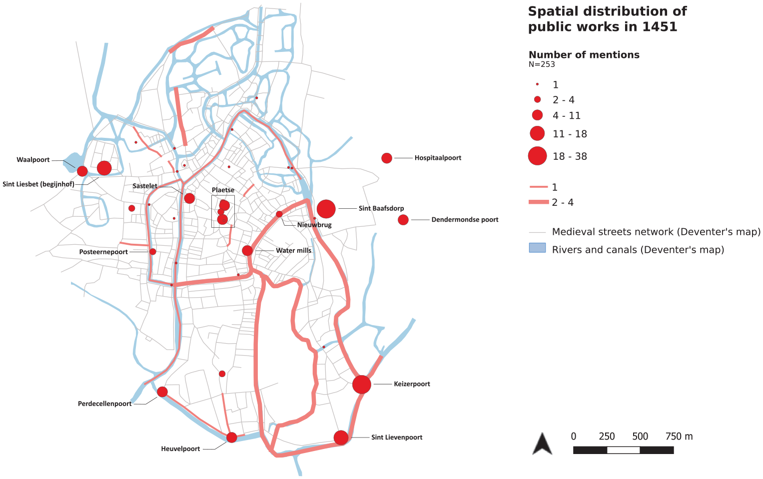
Spatial distribution of public works in 1451.
We can zoom in on the latter gate to see how specific nodes in the economy of movement were targeted as part of a military strategy. The Keizerpoort, in the southeast, is mentioned during this year almost forty times (total spent 14.000 d. gr.). Besides a guarding post, carpenters made fences (balustraden) around the waterways and installed rows of wooden posts (staketsels) in the water. Masons then fortified the gate and guarding posts, while others paved the roads underneath and around it. The towers of the gate were covered with tiles, which were fire-proof and thus better equipped to withstand fire arrows and other attempts at arson. 104 At the canal (vest), artillery (busschen) helped to defend the structure. At the same location, the koningskinderen opened the sluices at both the Keizerpoort and the Vijfwintgaten, with the help of specialized rigs (sconinxengienen). 105 Finally, in addition to all such constructions, exceptional expenses for war equipment pop up, such as on large mobile artillery (engienen, vogelaar), wooden figures (perhaps for soldiers to train, or deceit enemies), tents, spades, and baskets for rocks. 106
Concerning floods, the years 1421 and 1443, in particular, document what actions the authorities took to mitigate the damage of high waters. The Brabantpoort complex discussed above was a key node in this respect: in 1421, the year of the highly destructive St. Elisabeth’s Flood, the weirs near the Braambrug had to be opened extraordinarily wide (buiten kassen winden) “because of the flood (groets water).” 107 A few months later, workers were paid to put the weirs’ doors of the Braambrug back in, “which had been pulled out because of high waters.” 108 Masonry for “waterways and piers” was likewise a large additional expense. 109 Also, the dikes near the St. Lievenspoort and the Keizerpoort had to be strengthened to stop the rising water, and the road there, which was no longer passable, had to be repaired. The dam at the Steendam was heightened. 110 In 1443, the system again suffered some damage during a flood. 111 At the Braambrug, the water “broke through the weirs,” as one of the entries noted. The wooden planks had to be pulled out of the water and new or repaired ones later back in. In the same year, the weir’s doors are replaced at the Braambrug, involving many masons, metal workers, and several ships. 112
Such references exemplify instances of increased pressure and indeed occasional failure of the system, yet one from which it quickly bounced back. This was likely helped by the ability to divert resources immediately to complexes made vulnerable by an influx of water. Conversely, while droughts are much harder to detect in the sources, they posed just as much trouble, as ships could then no longer dock, water supply diminished for consumption, and the city’s more than hundred breweries and thirty bathhouses, and waste could no longer be adequately flushed out. 113
The degradation of infrastructures and buildings was a challenge that increased when they were built near waterways. It posed a constant threat to commerce and well-being, to both private property owners and the municipality. Yet it is clear that building so intensively near the water was attractive, especially for commercial activities, despite these risks. The strategy was to control and coordinate movements and flows, which, although very costly, in the end proved more valuable and useful than being located further and safer away.
In sum, beyond the calamities on the scale of the Black Death in the mid-fourteenth century and the war of 1379-1385, the evidence from the fifteenth century suggests a higher level of shock absorption and resilience. By policing and investing regularly, the city was better equipped to absorb certain shocks. This pertained to floods and war, but also to other aspects of socioeconomic stability. As scholars of Ghent noted, the continued care for water and road infrastructures, including monopolies for Ghent’s shipmen, helped to mitigate the harmful impact of the decline of the textile industry. 114 Similarly, the grain staple ensured a social stability that served elites, but also in practice prevented major shortages, which likely meant that fewer people suffered from famines in this large city. 115 It is likely, moreover, that different types of crises influenced each other. For instance, major investments to promote military safety in the southeast would likely mean less money to maintain waterworks in the central harbor. However, the convergence of interests in the same infrastructural nodes somewhat mitigated the need for such strategical financial decisions. Furthermore, as Figure 6 on 1451 shows, the city invested more on its outskirts and military strategic points that year, but did spend something on other, inner city works as well.
Frictions and Politics
In August 1432, Ghent’s former city surveyor Daneel van Zeveren was murdered by an angry mob. Together with the dean of the roofers’ guild (ticheldekkers), Joos Haesbijt, he was singled out during a period of mass unrest as a representative of the city’s mismanagement. Van Zeveren was nicknamed a “liver eater” (levereter), which was a more widespread insult for corrupt urban magistrates. A liver eater devoured the surplus of the urban body and destroyed one of its essential organs. 116 This was a striking confirmation of thinking about urban society as an organism. The metaphor envisions a type of surplus that could be (unlawfully) extracted. Van Zeveren had certainly been in a position to do so. In the preceding decades, through various governing positions and many public works projects, he managed to create a strong network and economic and political position. He presided as dean of the city’s carpenters’ guild in 1414, 1420, 1422, and 1431, and was also ten times elected leader of the woodworkers (houtbrekers). Between 1410 and 1422, he was a city surveyor (erfscheider). For more than ten consecutive years, he was thus involved in major building projects, as supervisor, architect, and contractor. 117
The collective anger directed at this man illustrates that public works offered the potential for certain groups, and even individuals, to accumulate various types of capital: sociopolitical, economic, and expertise. This shores up the diverse and potentially conflicting goals of public works. It is therefore important to, in the remainder of this article, complicate and avoid a too harmonious picture, yet without subscribing to what in historiography has traditionally been pictured as a corrupt and greedy urban oligarchy. 118 Frictions such as the one around Van Zeveren also lead to important questions: was the ideal of a prosperous and healthy city in movement, with clean water and smooth roads, made for the prosperity of the community, compromised in practice by the personal interests of elite factions? In some respects, it was. However, to think of practices in a dichotomy of private gain versus public good is inadequate. As noted in the introduction, late medieval urban societies were structured by complex networks of social groups, which negotiated their interests in both formal (such as through political representation) and informal ways (such as by family connections).
The governing elite on multiple occasions bit off far more than they could chew, resulting in delayed and sometimes unfinished building projects. That more personal interests were involved is also reflected in the division of expenses over the year. In the last month of accounting, expenses were systematically higher than in the preceding ones, suggesting that the administrations spent as much resources as they could before a new delegation of aldermen and surveyors took over. 119
The delegation of public works to private contractors (taswerk) reveals the monopolization of works by a small group—a building elite. During the fifteenth century, on average, 15 to 20 percent of the works were taswerk, but with large variations. 120 A prosopography of Ghent’s taswerk contractors revealed that between 1408 and 1460, 80 percent of the contractors did only 16 percent of the work. The vast majority of contracts landed in the hands of a group of about fifteen persons, who together carried out 62 percent of the taswerk. 121 Although in the second half of the fifteenth century the monopolization was slightly less extreme, it clearly continued. 122 In other words, the artisanal elite of the building sector made themselves bottlenecks or obligatory passage points in their social-political networks.
Partly, this was accepted and in fact desirable, because such individuals had all necessary financial assets, expertise, and connections to organize construction projects. However, Ghent’s authorities duly recognized the danger of an excess of dominance of one person or family in this network. This concern led to various official bans, such as on substandard building materials (issued in 1417, 1480s, 1540), or on surveyors taking on taswerk (issued in 1418, just after the major building campaign of the Great Meat Hall). 123 In 1452, an inquiry into abuse of funds brought to light various malpractices, such as buying cheaper and inferior materials, selling materials from demolitions, and spending on private properties. 124 Strikingly, the building elites are never noted to have bargained with laborers’ wages and seem to have abided by a shared interest in keeping wages at an agreed sum. 125
Some of the more direct financial benefits remained increasingly in the hands of (building)elites, thus contributing to socioeconomic inequality within those social groups involved. Besides competition between guilds for positions with the urban government, competition within the guilds meant that masters, especially those occupying leading offices (dekens), were able to reinforce their strong political and socioeconomic position, creating during the fifteenth century an increasing gap in status with regular artisans (gesellen). 126 In turn, these guilds were also less and less inclined to share the hard-won position and privileges for their group with newcomers aspiring guild membership. 127
However, as the reconstruction of public works above has demonstrated, the magistrates and those involved in executing works possessed thorough knowledge of urban mobility. Their policies and investments were not dominated by a tunnel vision on large prestige buildings or fortifications, but a rather thoughtful nodal strategy. Indeed, the organic perception of the city, in combination with the ideology of the common good, proved to be influential. Expertise was systematically integrated, such as by appointing master masons and carpenters as officials. This was a long-term learning process, which started in the twelfth and thirteenth centuries, when most of the infrastructures were first built, and continued across the investigated period. 128
Parallel to large urban building prestige projects nowadays, there may have also been benefits to Ghent’s community at large in promoting regional reputation that attracted commerce to the city. The commercial halls enabled the enforcement of trade privileges, which served the interests of the guilds using them. When it came to military interests, conflicts consisted of competing elites (princely, urban nobility, wealthy merchants). However, as in several other cities, especially in the southern Low Countries, artisanal collectives did have a say in these matters, and influenced and participated in military conflicts in myriad ways. Here the obligation for citizens to join urban militias should be noted as well. Thus, to have material and spatial investments that supported these military strategies was important for various social groups.
The same concerned public health and hygiene: although some entrepreneurs such as those possessing breweries or bathhouses were especially helped by clean waters, the active attitudes toward sanitation (policing and regulations) confirm that health interests, and its costs, were included in a broader sociopolitical negotiation of well-being among different stakeholders. A clean city mattered, for health, but also for commerce and prestige, and was mainly secured by protecting flows.
Conclusion
The mapping of public works, based on twenty-three sample years from the fourteenth and the fifteenth centuries, shows that Ghent’s urban authorities were much concerned about a network of specific places, in which they invested regularly and sometimes extensively. Those places were gates, bridges, markets, important buildings, and waterworks. Attention concentrated on these points because several types of interests related to communal well-being converged there. At these very places, infrastructures made by the city ensured the control of different flows: water, the circulation of pedestrians, and vehicles, but also for trade and waste management. Ghent’s trade, supply, defense, and sanitation depended on such mobilities. Furthermore, the city was capable of absorbing shocks (war, floods) by reducing risks through regular maintenance and monitoring. In other words, the authorities’ invested in, regulated, and policed specific bottlenecks within the city, which often served multiple of these goals, and thus reflect a deliberate spatial “nodal” approach. This nodal strategy of expenses went hand in hand with investments in waterworks and streets networks to avoid blockades and maintain traffic of people, materials, animals, and merchandise.
A thorough understanding of urban mobility or its economy of movement was fundamental to the politics of the common good. At least on occasion its constructors drew on rich intersecting cultures of water management, military technology, medical theory, and organic perception of community politics. The urban government of Ghent was one important participant within complex and sometimes tense negotiations between different stakeholders. This also means that two important questions need further research to be answered fully, namely, first, how other agents influenced the systems of flows and fixities, with either their own strategies or tactics of resisting those promoted by others, and, second, how municipal public works benefited the well-being of the community at large. Yet this article has demonstrated that strategic expenditures enabled commerce, trade, improved public sanitation, and that authorities created infrastructures and constructions that supported such activities.
Footnotes
Acknowledgements
The authors thankful for the input on earlier versions of this article during the workshop “Matter into Place” (Ghent, July 2021), and the Economic and Social History Seminar at Utrecht University (December 2021). We also want to thank the members of the Healthscaping Urban Europe Project, Lola Digard, Guy Geltner, Claire Weeda, and Taylor Zaneri for their comments and suggestions, and give a special thanks to Marc Boone for generously sharing his handwritten notes on Ghent’s fifteenth-century accounts.
Declaration of Conflicting Interests
The authors declared no potential conflicts of interest with respect to the research, authorship, and/or publication of this article.
Funding
The author(s) disclosed receipt of the following financial support for the research, authorship, and/or publication of this article: The authors received funding from the European Research Council (grant agreement no. 724114).