
Abstract
Despite structuring most of the urban world today, the deep history and long-term relationship between agricultural and urban spaces has been overlooked and undervalued in the Urbanocene. This article introduces a novel theory and method we term ‘patch urbanism’ to explore long-term relationships between settlement form and productive agricultural landscapes. We highlight the significance of such relationships in structuring extended urban regions throughout South, Southeast and East Asia today. Specifically, we examine the concept of patch urbanism in the context of Southeast Asia’s desakota landscapes using the largest city of the preindustrial world, Angkor, as an in-depth case study. By mapping and critically analysing archaeological features that structure current landscapes through modes of path dependency, we challenge dominant urban theories and the presentist bias in much urban studies research by emphasising the enduring spatial patterns across diverse cultural contexts, contradicting the notion that such patchy landscapes are inherently unsustainable, transient or merely transitional phases towards more centralised urban forms. The concept of patch urbanism offers a valuable lens for analysing and promoting sustainable transitions in urban regions, particularly in the context of Southeast Asia. This perspective challenges dominant urban theories by emphasising the historical resilience and ecological potential of dispersed urban forms. By embracing blue, black and green infrastructures, decentralised realities and adaptive rather than idealised approaches, patch urbanism provides an alternative framework for shaping sustainable and resilient cities of the future.
Introduction
In this article, we outline an initial theory of patch urbanism that integrates recent theoretical, methodological and empirical advances in landscape ecology and archaeology with approaches in urban research, planning and design to understand the spatial and temporal dynamics of urban landscapes and regions. In our conceptualisation, patch urbanism is both a noun and a verb. The ontological basis for patch urbanism is the identification of cities with spatially extensive mosaics of patches with distinct characteristics and functions that form open socioecological systems of network connections. As a verb, patch urbanism refers to the socioecological processes and properties that generate and reproduce these spatial patterns. The aim of this article is to demonstrate that patch urbanism is a salient addition to the urban vocabulary (sensu Schmid et al., 2018) and a useful term to describe the spatial and temporal dynamics of urban spatial morphology. We develop patch urbanism as a practical framework for assessing factors that support long-term urban sustainability and propose that it provides a theoretical point of departure for comparative analyses of urban morphologies and modes of producing urban space, in the distant past, between the past and the present and for appreciating legacies of the past and present into the future. We show how this framework describes the spatial morphology and dynamics of contemporary urban systems, focusing on the desakota type of city in the rice-cultivating areas of South, Southeast and East Asia (hereafter ‘SSEEA’). Analysing different types of patches, patch interactions and their contribution to urban ecology and, ultimately, the durability of the 9th- to 15th-century CE Khmer capital city of Angkor (in contemporary Cambodia), we demonstrate that patch urbanism has considerable time–depth and emerged with the evolution of early premodern cities in the area. We suggest how the long-term record of patch urbanism in SSEEA can be used to estimate the longevity of these urban systems and how these insights can inform urban sustainability transitions. We conclude that a theory of patch urbanism has the potential to be more widely applied to better understand the spatial and temporal dynamics of urban landscapes and regions.
Towards a theory of patch urbanism
Patch urbanism is informed by consilient discourse developments in three fields. Firstly, the shift in ecological theory from assumptions of the balance of nature to a focus on system nonequilibria, nonlinear interactions, hierarchical patch dynamics, panarchies and emergent properties of complex systems (e.g. Wu and David, 2002; Wu and Loucks, 1995) directs attention to the framing of cities as open, relatively unbounded systems of networked patches characterised by spatial and functional heterogeneity (e.g. residential areas, industrial compounds, office districts, commercial complexes and various blue, black, green and grey infrastructures). The spatial arrangement and interactions of these have the potential to generate emergent properties and influence morphogenetic processes as well as system integrity, resilience and sustainability (Li et al., 2013; Wu, 2014; Zhang et al., 2013). For instance, landscape ecologist Forman’s (1995; Forman and Godron, 1981) approach to studying landscapes based on a conceptualisation of the ‘patch–corridor matrix’ has influenced a range of fields, including urban design (Marshall et al., 2020). Typically, however, landscape ecology is concerned with non-linear interactions between non-human biota assessed at a temporal scale of decades. Similarly, we follow Wu (2014: 213) to define urban sustainability as ‘an adaptive process of facilitating and maintaining a virtuous cycle between ecosystem services and human well-being through concerted ecological, economic and social actions in response to changes within and beyond the urban landscape’.
Secondly, a theory of patch urbanism is informed by the social sciences and humanities’ attention to human behaviour and cultural agency, and historical science’s assessment of social change. Archaeological timescales and approaches to temporality provide a broad template for assessing urban dynamics and change at multiple intergenerational timescales, including the long-term scales of several centuries and millennia (e.g. Hawken et al., 2025b; Isendahl et al., 2025). Recent urban archaeological research has provided a wealth of new data – including from light detection and ranging (LiDAR) mapping of regions in the humid tropics with inaccessibly dense vegetation (e.g. Chase et al., 2011; Evans et al., 2013; Rostain et al., 2024) – that contributes to the questioning of stereotyped assumptions about premodern urbanisation and urban forms globally (e.g. Roberts et al., 2024). This information demonstrates that low density of built space and the interspersion of urban, agricultural and other land uses in spatially extensive and ambiguously bounded agro-urban landscapes were commonly featured properties of premodern urban morphologies and metabolism (e.g. Chase and Chase, 2016; Fletcher, 2009; Hawken et al., 2025a; Isendahl, 2012; Isendahl and Scarborough, 2024). In SSEEA, for instance, detailed and large-scale mapping at Angkor reveals extensive rice-growing landscapes seamlessly integrated within the urban fabric (Hawken, 2012) and demonstrates the potential of patch urbanism to support large populations while maintaining ecological health and resilience over extended periods (Klassen et al., 2022). We argue that this body of evidence sheds light on the long-term emergence, history, diversity, resilience and sustainability of cities characterised by patch urbanism.
Thirdly, these advances in the natural and historical social sciences and humanities deepen recently emerging and partly overlapping concepts in urban research, planning and design that expand upon and build the urban vocabulary to better describe, explain and envision new ontologies of cities. This growing vocabulary is varied but complementary and includes terms such as agro-urbanism (Carter et al., 2021; Isendahl, 2012), agropolis (Mougeot, 2005), global suburbanism (Keil, 2018), horizontal metropolis (Barcelloni Corte and Viganò, 2022; Cavalieri and Viganò, 2019; Viganò et al., 2018), landscape urbanism (Waldheim, 2016), multilayered patchwork urbanisation (Schmid et al., 2018, 2023), patchwork metropolis (Neutelings, 2022; Pisano, 2018), polycentricity (Kloosterman and Musterd, 2001) and ruralopolis (Qadeer, 2000), amongst others. Arguably, these crosscut several of Fraker’s (2007) urban design force fields – in particular hybrid urbanism and urban ecological reconstruction – to dispute the adequacy of conventional Cartesian dualisms that remain in the generic urban vocabulary (urban/rural, creatively progressive/traditionally conservative, homogeneous/heterogeneous, centre/periphery, built/non-built, etc.), and provide abstract models that better capture the global, regional and local diversity of lived, observed and projected urban environments. Although (in the main) of recent coinage and (occasionally) informed by postcolonial critiques (Parnell and Oldfield, 2014), the discourse significantly builds on (primarily Western) urban planning and design ideas that extend back to the late 18th century CE but have mostly been advanced since the second half of the 20th century CE, often to envision alternatives to the Great Acceleration of North American urban sprawl (Barcelloni Corte and Viganò, 2022). For instance, in the late 1980s, Dutch architect Neutelings’s (2022) tapijtmetropool (literally carpet metropolis) paid particular attention to the patchwork-like properties of regions in the Netherlands integrating urban, agricultural and other land uses. His work, subsequent elaborations (Pisano, 2018) and similar concepts (e.g. Schmid et al., 2018, 2023) are distinct by using ‘patchwork’ in an ontological sense to identify the extensive and complex arrangements of networked heterogeneous spatial units in integrated regions, rather than the more common generic metaphorical use of ‘patchwork’ and ‘patch’ (e.g. Florida, 2018; Glaeser, 2011). The discourse also draws on examples of urban morphologies and modes of producing urban space in the Global South. For instance, the horizontal metropolis concept is informed by the desakota type of cities that McGee (1967; Barcelloni Corte and Viganò, 2022; Viganò et al., 2018) initially described in Indonesia and that is discussed in this article.
Patch urbanism is the overlap of these three discourses: it integrates landscape ecological theory with global urban archaeology’s perspectives to long-term processes and insight on past spatial and temporal urban diversity with urban studies’ (in its inclusive sense of research, planning and design) concern for identifying and addressing contemporary problems. This approach to delineating a unified theory of patch urbanism suggests a series of assumptions and analytical affordances that allow for an integrated understanding of the socioecological processes and spatial and temporal dynamics shaping urban systems. From our archaeological vantage, patch urbanism is an expedient tool to emphasise the long-term historical development of urban landscapes, including that many contemporary urban forms are cultural legacies of those in the premodern past and that urban spatial morphologies are contingent on long-term, non-linear dynamics. Patch urbanism also highlights the importance of socioecological processes in shaping urban systems, acknowledging the interconnectedness between human settlements and the properties of the natural environment (Band et al., 2005). Perhaps most significantly, patch urbanism champions the diversity of urban patterns across different regions, cultures and points in time, embracing process, dispersal, heterogeneity and interconnectedness to offer a more nuanced understanding of the complex spatial realities of urbanity (Leitão et al., 2012). We suggest that patch urbanism is particularly pertinent in stressing the spatial and temporal diversity of urban form in the humid tropics of the Global South, which has not had the same weight of scholarship and, when it has, usually carries the burden of dominant Western forms and models that tend to emphasise centrality, density and rural–urban separation (Kong and Qian, 2019).
Patch urbanism draws attention to the inherent properties of space across time rather than any preconceived idea of spatial types and is, therefore, particularly helpful in detailing the spatial and functional complexities and ambiguities of urban systems. As a neutral geometric concept, a patch represents whatever value or measure is ascribed to it. For instance, a patch pattern can be classified according to the spectral values of remote-sensed landscapes or through identifying diagnostic landscape features using object-based recognition. For instance, landcover of housing or rice fields might be used to classify a patch, as has been suggested by Cadenasso et al. (2013). While a patch might integrate a range of heterogenous features once defined, this variation has for the sake of analytical clarity commonly been overlooked in hierarchical patch dynamics (Wu and David, 2002). In patch urbanism, however, patches can be classified in different ways depending on which spatial relations are investigated and on what ontological and epistemological basis.
The desakota as a long-term patch landscape
The SSEEA macro-region 1 provides a compelling case to explore the relevance of patch urbanism. Intensive rice cultivation is a central feature of many contemporary urban landscapes, demonstrating the integration of agriculture in urban life in an intensely patchy spatial morphology (Hawken and Fletcher, 2021). We use the term ‘desakota’ to describe this pattern and the cultural and socioecological histories that generated it. The term combines the Indonesian words for ‘village’ and ‘city’ and captures urban phenomena first described and named by McGee (1967, 1971, 1973, 1991) during fieldwork in and around Jakarta in the 1960s. McGee observed that Jakarta’s growth did not erase its rural surroundings but resulted in a mosaic of urban and agricultural landscapes. The concept encapsulates the fusion of urban and rural elements in a distinct metropolitan form characterised by the coexistence of central urban cores, peripheral suburbs and interspersed areas of high population density and traditional agricultural practices, including rice paddy cultivation. The spatial patterning of urban agriculture (UA) within desakota cities is defined by topographic conditions, hydrology, landownership and infrastructure patterns. Bodies of water, wetlands, floodplains, slopes unsuitable for construction, infrastructure easements, private gardens, urban-village landscapes, rooftops, quasi-public land, public reserves and space between factories all provide locations for a mosaic of diverse UA sustenance strategies (Smit et al., 1996: 75–91). Those who have traversed the laneways and urban canal systems of Bangkok, for instance, can attest that much of the metropolitan area is used for UA.
The desakota model contributes a contextual mosaic or ‘matrix’ for the spatial morphology of contemporary urbanism not only in Greater Jakarta and elsewhere in Indonesia but across much of SSEEA (McGee, 1991). Despite dramatically increasing urban populations over the last 60 years, wet rice cultivation continues to define urban ecology and sustenance. Hence, the desakota pattern that McGee described was not simply a snapshot of an early phase in the evolution towards a conventional urban model but a distinctive spatial morphology consistent throughout SSEEA that has proven resilient to change in both emergent and developed economies. Indeed, archaeological and historical records (Hawken, 2013; Manuel et al., 2021; Pottier, 2000) suggest that it has a deep cultural history extending back into premodern times, ultimately to the emergence of rice cultivation as a dominant type of urban subsistence economy during the first millennium (Higham, 2017; Stark, 2015). Today, this approach to organising urban and agrarian space is a living biocultural heritage (Fletcher et al., 2007) embedded within the landscape and with legacy effects on both urban planning and the structuring of formal and informal urban space production.
There are key properties that characterise desakota systems, shaping their identity, landscapes and livelihoods. Many of these are driven by the unique characteristics of intensive rice production (Bray, 1986), as argued by McGee (1991) in one of his original expositions on the desakota. The distinctive characteristics of rice economies, as noted by Bray (1986) and Qadeer (2000), are fundamental to understanding desakota systems. Rice cultivation yields exceptionally high nutrition value per unit area, enabling dense populations, but this productivity exacts a correspondingly high labour cost. The distribution of labour is both intensive and asymmetrical throughout the year – more so than other crops – creating recurring bottlenecks that necessitate high degrees of sociability and collective coordination in both pre-modern and contemporary societies.
Rice cultivation benefits significantly from increased infrastructure, especially water management systems, but not in the manner typically envisioned by conventional development models. In societies both past and present, hydraulic infrastructure is deployed to create both certainty and reliability rather than simply to maximise yields. In essence, water management systems are essential for avoiding the dire consequences of rainfall irregularity – both drought and equally disastrous floods – that can devastate rice production. This intensive agricultural foundation enables remarkably high population densities in agrarian landscapes.
Contemporary desakota environments such as those in many parts of SSEEA frequently achieve population densities that surpass those found in most metropolitan areas of, for instance, the United States or Australia. This demographic and economic reality challenges conventional assumptions about the relationship between urban density and agricultural production, elucidating how rice-based agrarian systems sustain urban-level populations across dispersed territorial configurations.
In the following, we list five desakota characteristics of particular relevance to patch urbanism. Noting that McGee and others have more extensive lists, ours is distinguished by the inclusion of point 5, which emphasises the agricultural heritage of desakota systems through time.
Persistence of agricultural patches. Agriculture remains integral to the urban fabric and, despite the pressures of urbanisation and industrialisation, coexists with urban development (Hara et al., 2005; McGee, 1991, 2002; Veeck et al., 2021).
Proximity of agricultural production to urban centres. Agricultural production is located with access to urban centres, facilitating easy linkages with markets, infrastructure and services. Proximity allows for a dynamic interaction between urban and agricultural economies, enhancing the integration of local food systems (McGee, 1991; McGee and Robinson, 1995; Pribadi and Pauleit, 2015).
Intensive and mixed land use. Desakota systems are characterised by intensive land use that integrates various activities, including residential, commercial and agricultural activities. This mixing fosters diverse economic opportunities and livelihoods (McGee, 1991; Xie et al., 2006; Xu et al., 2019).
Economic hybridity. Desakota dwellers maintain dual identities, dynamically switching between those that might be considered ‘more urban’ and those considered ‘more agricultural’, engaging in both urban service-based employment and agricultural practices. Mobility between livelihoods provides a measure of resilience against economic fluctuations and insecurity (Desakota Study Team, 2008; McGee, 1991; Ortega, 2020).
Biocultural heritage. UA is based in local foodways, with traditional agrosystems and practices contributing to food security, biocultural diversity and the preservation of cultural identities (Fletcher, 2009; Hawken, 2017; see also Isendahl et al., 2021).
While sharing common traits, contemporary desakota systems exhibit diversity across different regions (Figure 1). In South Asia, for instance, the diffusion of communication technologies and mechanised transport has played a crucial role in sustaining desakota dynamics by enabling bottom-up household agency (Desakota Study Team, 2008: 19–21). In contrast, China’s contemporary desakota models have largely emerged from top-down planning within the context of a hybrid autocratic capitalist market economy and feature large-scale centralised public development (Desakota Study Team, 2008: 19). The desakota model is not limited to SSEEA, however, but can be compared to similar kinds of urban–agrarian spatial integration in other parts of the world where the patchiness of the landscape of agricultural, residential and other urban land uses has occurred, for instance through a combination of rapid growth, economic inequality and social or political instability (Drechsel and Dongus, 2010; Korah et al., 2019). Hence, the detailed configuration and governance of desakota systems vary significantly across different spatio-temporal contexts.
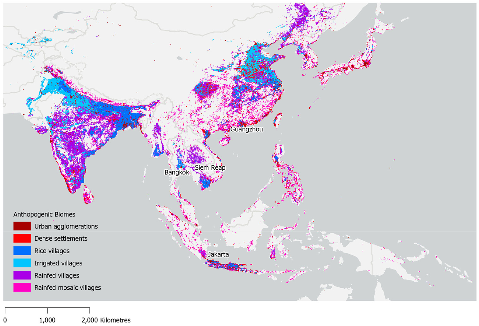
Rice-growing regions throughout SSEEA. The biomes associated with the ‘Asian Rice Belt’ have been selected to highlight the distribution of desakota systems.
Defining Angkor’s patch landscapes: Approach and methods
Moving from contemporary reflections of the desakota, we come to Greater Angkor, which was the largest city by spatial extent in preindustrial history and, as an example of a distinct and understudied form of desakota, a significant case study for the insights it presents on the long-term dynamics of patch urbanism (Fletcher, 2009; Hawken and Fletcher, 2021) and urban sustainability. Angkor’s monumental temple stone architecture, mainly dating to the 9th–15th centuries CE, has dominated both public imagination and scholarly investigation of this city (Coe and Evans, 2024). This has partly been a pragmatic question, as much non-monumental residential architecture and infrastructures were constructed from materials that rapidly decay in the humid tropical climate. However, advances in documentation technologies as well as theoretical frameworks to interpret and explain data have come together over the last three decades (Hendrickson et al., 2023) to give this expansive landscape a new visibility. An international collaborative research programme – the Greater Angkor Project (GAP) – has significantly enhanced our understanding of Angkor by combining archival sources, remote sensing, extensive ground truthing and innovative cartographic techniques (Chevance et al., 2019; Evans et al., 2013, 2023a). As a result, scholars now see Angkor not simply as a series of walled city–temple complexes with some of the largest temples ever constructed, but as a ‘horizontal metropolis’ extending over more than a thousand square kilometres. Maps generated from GAP reveal that the city formed a mosaic of small rice-growing temple communities, peripheral urban complexes, rice estates and suburbs linked together by an extensive hydraulic network of canals and reservoirs that provided a matrix for rice field distributions (e.g. Pottier, 1999; Evans et al., 2013). These rice-growing communities have been the most sustainable aspect of the metropolis, enduring even when the massive infrastructure and large temples fell into disuse.
It is difficult to overstate the importance of rice at Angkor. Rice was the key economic good within the Khmer Empire, vital to economic transactions in a society that had no standard currency (Lustig, 2009) and the principal source of nutrition along with fish (caught in rice paddies, lakes and canals), frogs and other sources of protein. Rice was cultivated in gridded zones of finely calibrated patches crafted to manage an environmental mosaic of variations in topography, hydrology and soil distributions (Hawken and Cobo Castillo, 2023). Prepared and managed at various spatial scales in the city’s different sectors, ecological niches and sociocultural settings in relation to changing climatic, environmental and sociopolitical conditions, rice fields were a highly significant principle of organising and producing urban space, demonstrating the close relationship and dynamics between foodways and urban form (Hawken and Klassen, 2023; Isendahl et al., 2021).
We used a scale-based patch classification as a starting point to examine the function of different types of patches, patch interactions and their contribution to urban ecology and, ultimately, to the sustainability of the city of Angkor. The study aimed to identify and categorise the premodern Angkorian rice field systems using geospatial data and archaeological evidence and to distinguish them from more recent traces and settlement. What became almost immediately apparent was the continuity in agricultural use from premodern times to the present. The study drew from high-resolution satellite imagery, aerial photography and ground-truthed data collected across the Greater Angkor region, which revealed extensive archaeological traces of Angkorian agricultural landscapes (Hawken, 2012). These remote-sensing sources (which include a high-resolution photogrammetrically corrected map produced by Hawken (2012) and created from FINNMAP (1992) aerial imagery and SPOT 5 (European Space Agency, 2004) satellite imagery) enabled the mapping of field boundaries, water management features and agricultural plot patterns as they related to the architecture and larger infrastructure of the city. In this study, rice fields were initially automatically classified according to their orientation, with cardinally orientated fields identified (Figure 2), the cardinal orientation being the key alignment for Angkorian-era features. They were then further classified using a range of manual morphological characteristics, including size, proximity to urban infrastructure, regularity of the field geometry and stratigraphic relationships between each other and also to diagnostic archaeological features such as community temples. These methods facilitated differentiation between modern field systems and their premodern antecedents. The close relationship between urban settlement features in the Khmer landscape meant that the recovery of a gridded rice field patch was often assisted by the presence of a community temple (prasat) or community pond (trapeang) and, inversely, the recovery of a landscape feature such as a prasat was sometimes helped by the presence of a regular rice field grid (Evans, 2007; Pottier, 1999).
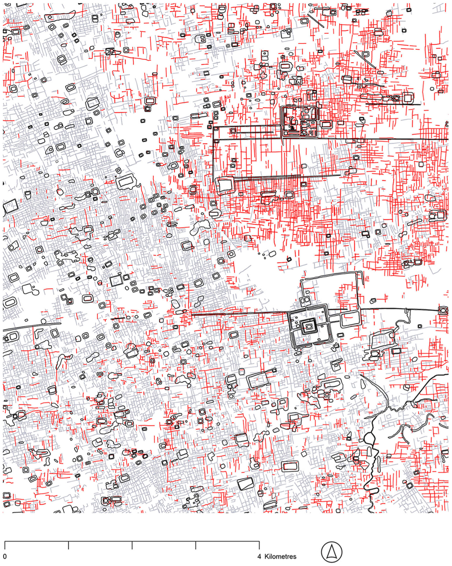
Filtering of rice field patches using orientation. Two distinct classes of orientation are highlighted. Cardinally orientated rice fields are highlighted in red. This is the key signature of Angkor that aligns the majority of the urban settlement features, although oblique fields of different orientations – highlighted in grey – structure the landscape in significant ways too.
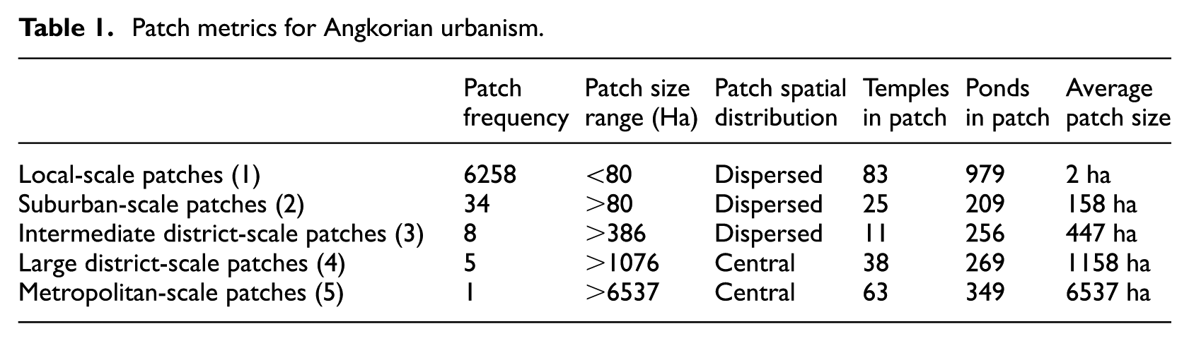
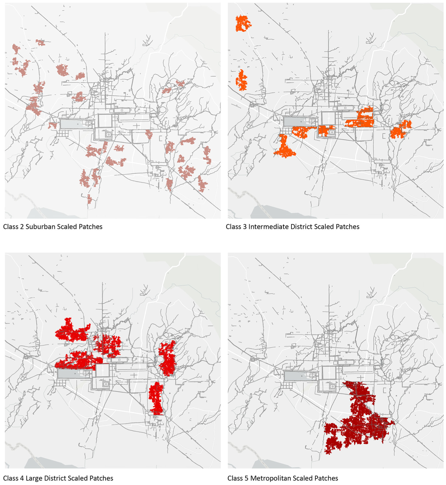
Once patches had been distinguished, they were further classified in terms of scale to provide insight into their management and functional relationship with the environmental and urban context. Finally, we employed five scales, each facilitating the observation of specific settlement phenomena. The five-part classification was generated from iterative filtering of rice fields using various algorithms. A local breaks or ‘Jenks’ algorithm (ESRI, 2024) was found to be the most incisive in distinguishing different scales of cardinally orientated field systems. This automated process groups similar values together and maximises the differences between classes, revealing local patches (<80 ha), suburban patches (>80 ha), intermediate district-scale patches (>386 ha), large district patches (>1076 ha), and metropolitan-scale patches (>6537 ha) (Figure 2, Table 1).
Patch metrics for Angkorian urbanism.
Results and outcomes: Urban scales-and socioecological systems
Local and suburban-scale patches
Cardinal rice field systems, shown collectively in Figure 2-4, are the most dominant of all classes, covering the most extensive area and forming the largest patches across the landscape. Despite this, cardinal systems show a high degree of fragmentation, with many small patches below 80 ha dispersed across the metropolitan 2 area. The smallest class of patch (‘local patches’) is extremely common, relatively evenly distributed and has an average size of 2 ha. The next step up in scale in this classification system, the suburban patches are generally evenly distributed throughout the metropolitan area (Figures 3 and 4) but are associated with three areas of the landscape forming loose clusters in the west and east. Each of these parts of the landscape has long time–depth, with cardinal-designated systems embedded in what has been suggested as an archaic coaxial rice field system dating from the pre-Angkorian period (6th–8th centuries CE) (Hawken, 2012) (Figure 4).

Patches classified using the patch size of contiguous cardinal rice fields using a natural breaks algorithm.
Different scales of patches within Greater Angkor.
Local and suburban patches form the most common element of Angkor and are associated with many local temples and ponds dispersed in the urban fabric that are as much an identifying feature of Angkor as its central temples (e.g. the Bakheng), complexes of monumental stone architecture (e.g. Angkor Thom and Ta Prohm) or giant water reservoirs (Jacques and Lafond, 2007). Significantly, these patches are the most durable functional element of the premodern urban system and still orientate and sustain community-focused agricultural settlements today, long past the formal ‘decline’ or ‘collapse’ of the city in the 14th century CE when economic and administrative functions shifted to areas further to the east of what is present-day Cambodia (Evans et al., 2023b; Polkinghorne, 2018). These patches integrate and maintain archaeological rice field walls to support rice cultivation and draw upon local ponds of premodern origin for community uses.
District-scale patches
At the next level up from local and suburban patches are intermediate district-scale patches with an average size of 447 ha. These more extensive patch landscapes are typically offset from major hydraulic infrastructure such as reservoirs and canal systems. They also, however, feature in more peripheral settlements far from the major temples and infrastructure. The most coherent district-scale grids are located close to the early urban centre surrounding the Pre Rup temple complex (Pottier, 2003), and with large linear rice field distributions south of the East Baray reservoir, around the Bakong temple complex (Pottier and Bolle, 2009). This demonstrates concentrations of intermediate rice field grids around 9th- and 10th-century CE centres of development. However, the peripheral systems to the northwest show that major investments in rice field expansion were used in direct association with centralised infrastructural programmes of development and also to colonise peripheral communities and landscapes that preceded Angkor (Evans, 2007; Hawken, 2012; Moore, 1998). Typically, such early communities managed local smaller-scale ecosystems in contrast with the mega-infrastructure of the Angkorian period.
In contrast to the intermediate-scale district patches, the next class up featuring large district-scale patches with an average size of 1158 ha does not occur on the periphery but rather shows a strong association with major hydraulic metropolitan-scale infrastructure and is aligned as linear matrices with the canal and reservoir hydraulic systems of Angkor. The clarity of the vertical matrices at the centre and to the east of Greater Angkor is evident in the highly ordered geometries of hydraulic superstructures associated with the settlements surrounding major settlement clusters (such as Phnom Bok, the East Baray and Roluos) and are most likely linked to ambitious hydraulic expansion programmes during the 9th and 10th centuries CE.
Large district-scale patches are associated with the Great North Canal that extends from the central area of Angkor. Several major patch systems exist to the north of the West Baray (a vast reservoir developed in the 11th century CE), centred around the remnants of temples such as Kok Kou (Figure 2). There is a tendency for district-scale patches to be slightly linear and aligned with the east–west orientated hydraulic elements of the area. District-scale systems also form a major independent rectilinear grid north of the West Baray.
The homogeneity of much of the large district-scale systems of Angkor suggests that these were new establishments that did not need to take existing physical infrastructures and ownership patterns into as much consideration. For example, the large district-scale associations near temples surrounding the eastern settlement of Phnom Bok represent almost pure grids uninterrupted by alternative orientations. Equally, their association with massive infrastructure suggests that these were state-sponsored systems and may have been part of an effort to extend the city into more marginal agricultural landscapes. The Phnom Bok association is also remarkable in that it has very few temples associated with the matrix. This may also be linked to the fact that this was a system directly engineered and managed by the state, without the need for local elites to manage it.
To the east of Roluos River and to the west of the West Baray, there are no large district-scale cardinally orientated rice field systems. Here, different types of rice field systems form more coherent and dominant networks. In these contexts, local patches of cardinally orientated rice fields form isolated and much more limited patches embedded in extensive distributions of obliquely orientated rice fields. This may suggest that cardinal Angkorian establishments either were eroded by later grids or relied on what we hypothesise to be pre-existing oblique grids for their economic basis.
Metropolitan-scale patches
The single metropolitan-scale system described in this classification demonstrates spatial association with the immense infrastructural programmes of 10th-century CE Angkor and the rapid expansion of the city in the century that followed (Fletcher et al., 2008; Klassen and Evans, 2020). Close examination of the metropolitan-scale patch reveals a diversity of development approaches. The patterning of the landscape suggests both expansionist and infill approaches in the formation of the extensive grid. The first approach involves the massive transformation of the landscape according to a formal plan or vision based on consistent grid structures and linked to hydraulic infrastructure. The second approach involves a progressive development of the landscape through a dispersed grid of rice fields that are subsequently integrated to form a larger ‘super patch’. Today, such super patches and centrally planned grids still function as rice fields and operate as networks of smaller-scale community settlements. In other words, they operate as smaller patches. The linkages with significant temples and the now dysfunctional and abandoned hydraulic infrastructure are no longer maintained.
Klassen and Evans (2020: 7) have argued that the water management system at Angkor ‘was a hybrid one, combining elements of top-down and bottom-up water management’. The metropolitan-scale patch similarly integrates elements of both, suggesting its adaptive capacity and time–depth. The variety of patch systems existing in the large metropolitan-scale patch evidently supported both central urban institutions and more dispersed and extensive areas to flourish over the long term through their very scale. Throughout the 10th and 11th centuries CE, urban development was rapid and it integrated multiple strategies both local and pragmatic and of a monumental landscape scale to support both functional agricultural and ritual means. The adaptive nature of this metropolitan patch supports the interpretation that after the 11th century CE, there was ‘a shift from the construction of temple communities on previously undeveloped land towards the development of large, state-sponsored temples on land previously owned and developed by temple communities’ (Klassen and Evans, 2020: 7).
Patches across time
In reflecting on the temporal dimensions of Angkor’s rice field patches, we observe that local-scale patches exhibit remarkable continuity from Angkorian times (9th–15th centuries CE) to the present, representing over 1000 years of continuous landscape occupation and adaptation. These small-scale, community-centred urban patches have developed, evolved and persisted through multiple political, economic and climatic transformations precisely because of their scale, adaptability and alignment with local socioecological systems. In contrast, district- and metropolitan-scale patches were established within more limited timeframes and can be linked to specific urban moments within the formal Angkorian period (9th–15th centuries CE). These larger-scale landscape interventions required centralised administration, larger infrastructures and substantial resource mobilisation that could not be sustained after economic and political fragmentation of the society.
This temporal differentiation strengthens our theoretical contribution by demonstrating that decentralised, small-scale landscape urban patches exhibit greater resilience and adaptability through time than larger-scale urban forms tied to centralised infrastructures. The small-scale patches themselves indicate time–depth through their complexity. They form the base pattern which larger metropolitan-scale patches are inserted within and must adapt to. Close observation reveals that they also tied the city of Angkor to its wider regional landscape linking with more archaic patterns that preceded Angkor (Hawken, 2013). Rather than representing a transitional phase towards centralisation, local-scale landscape patches have proven to be the most enduring form of settlement organisation, persisting long after the larger urban infrastructure ceased functioning. We can say then that patchiness has proved to be an asset tied to the ecology and operation of the landscape across various ruptures in the historical trajectory of the city of Angkor.
Concluding discussion: A working theory of patch urbanism for design and planning
The desakota type of city represents a paradox; its mix of the urban and the rural simultaneously highlights ecological and social vulnerability alongside development opportunities and potential (Desakota Study Team, 2008). These are properties largely consistent with other recent contributions to the urban vocabulary of contemporary hybrid urbanism and urban ecological reconstruction. As we have shown, however, the patch urbanism of desakota cities is not a new phenomenon but extends back to the early phases of premodern urbanisation in SSEEA. Arguably, this record can be used to further inform the temporal perspectives of the extent to which desakota spatial patterning impacts – positively and negatively – the quality of life of large urban populations (e.g. Which are these? For how long? What are the trade-offs?). For instance, while a higher standard of living is available to farming populations because of access to industrial and urban economies, the land uses associated with these economies place an added strain on agricultural and rural landscapes (see Sajor and Ongsakul, 2007). Water pollution, soil contamination, air pollution and increased exposure to disasters and human rights abuses particular to urban situations are all realities of contemporary desakota (Chen et al., 2017).
The tools and methods of patch urbanism are developed in relation to the prospection of past landscapes and have proven useful for comparing Angkor – with its temples dotted in the midst of vast expanses of open space that supported the city through an agrarian economy – to recent concepts coined to describe a new ontology of contemporary cities: agropolis, global suburbanism, horizontal metropolis, landscape urbanism, multilayered patchwork urbanisation, patchwork metropolis, polycentricity, ruralopolis, etc. The spatial approach of patch urbanism to dispersed landscapes found throughout urban history, however, requires a new unifying vocabulary. Championing the consolidation of landscape ecological theory with global urban archaeology’s perspectives on long-term process and insight into past spatial and temporal diversity with urban studies’ concern for contemporary problems, patch urbanism can support the abandonment of presentist temporal bias and ahistorical knowledge framing among global agencies and governments (Hawken et al., 2025b) to better appreciate the temporalities of sustainability and the past, present and future of spatially extensive and complex urban regions, including the detailing of the premodern roots of contemporary desakota landscapes.
Patch dynamics theory transforms our understanding of urban spaces, revealing how open areas actively shape cities rather than serving as passive background to the making of cities and settlements. This insight applies equally to ancient complexes like Angkor and modern metropolitan regions. Urban studies scholarship often treats open spaces as a neutral background awaiting development, but this view fundamentally misunderstands their role in urban systems. The concept of heterogeneous patch landscapes demonstrates that no spatial matrix is truly neutral. Rather, what we consider ‘neutral’ simply reflects what lies outside our current analytical focus.
The analytical power of patch theory lies in its ability to transcend traditional urban–rural classifications. By treating all units of space as potential patches, we move beyond constraining categories like ‘village’, ‘town’ or ‘city’ or indeed ‘rice field’. This approach enables a more helpful understanding of how metropolitan regions develop through multiple, concurrent processes. Quantitative and qualitative methods for identifying and analysing patches provide empirical rigour to this theoretical framework.
The methodological significance of patch-based analysis lies in its capacity to facilitate multi-linear interpretations of metropolitan development, transcending traditional typological constraints imposed by cultural–spatial categories. Through methodologies for patch identification, this approach enables nuanced analysis of urban spatial dynamics that moves beyond conventional dichotomies. The theoretical neutrality of the patch concept provides an analytical framework capable of addressing the complex, non-linear nature of urban development processes.
This research therefore makes three distinctive contributions to urban studies. First, it introduces patch urbanism as a novel theoretical framework that synthesises the temporal depth of archaeology with the complexity of ecology and the critical spatial perspectives of urban studies. Second, by linking contemporary desakota patterns with the deep historical precedents of Angkor, it demonstrates the idea that dispersed agrarian urbanism represents a persistent and sophisticated urban form – rather than an incomplete phase of urbanisation.
Third, it advances new methodological approaches by integrating methods from these disciplines to reveal the complex spatial organisation of patch-based systems across multiple scales and cultures. Together, these contributions establish patch urbanism as a distinct and robust framework for understanding alternative urban configurations that challenge conventional centralised, exclusive and binary models of urban development.
In recent decades, the focus of city making and planning has been on the monumental ‘global’ city (da Cruz et al., 2019; Wiedmann and Allen, 2021; see also Robinson, 2002). Where villages and small towns are not on the agenda, the city-centred rhetoric becomes virtually a self-fulfilling prophesy, with cities getting bigger, better and more exciting, and attracting the majority of urban sustainability scholarship and investment, while villages and small towns are essentially left to their own devices (Carlow, 2016). This is unsurprising, as the concentration of capital and expertise is very much clustered around the globalised capitals of today. It is therefore ironic that the case of Angkor demonstrates that the most enduring systems from such impressive and mighty past societies are not the complicated institutional structures nor large-scale technological superstructures but rather the enduring, complex, yet ultimately modest patchy systems and infrastructure of the agrarian landscape. It is this repetitive, even prosaic element that made up most of the city and was responsible for its sustenance that has been the principle and most durable and sustainable element within the city. The rice fields are the only elements that are used principally in the same way and for the same reason they were used a millennium ago. These affordances of durability deserve greater attention and may indicate ways to structure current and future cities.
The Urbanocene’s limited temporal imagination has constrained our capacity to transcend present-day viewpoints and appreciate the structures inherited from our predecessors, ultimately narrowing our ability to envision and create more resilient urban futures. Patch urbanism offers a framework to strengthen urban studies’ spatial and ecological connections with time by recognising cities as dynamic, evolving ecosystems of interconnected patches – each with their own temporal rhythms and evolutionary trajectories – rather than monolithic entities fixed in a single moment. By embracing this perspective, we can better integrate temporal consciousness into urban design and planning practices, enabling us to more effectively consider past structures, present needs and future adaptability in relation to the design and management of cities.
Footnotes
Acknowledgements
The authors would like to thank editor Professor Markus Moos and journal manager Ruth Harkin for their care and critical support throughout the review and publication process. We also extend our gratitude to the three anonymous reviewers whose thoughtful comments and suggestions substantially improved the manuscript. The article was inspired by the recently published special issue of Urban Studies 62(3) on ‘Long-Term Intergenerational Perspectives on Urban Sustainability Transitions’, which considered how archaeological knowledge might inform and assist with the urban challenges that we face to today.
Funding
The authors received financial support for international collaboration from the Environment Institute, University of Adelaide.
Declaration of conflicting interests
The authors declared no potential conflicts of interest with respect to the research, authorship, and/or publication of this article.