
Abstract
Southwest Asia saw the emergence of large settlements in the Early Holocene, and the world’s first urban communities around 6000 years ago, with cities a feature of the region ever since. These developed in diverse environmental settings, including the dry-farming plains of Northern Mesopotamia, the irrigated alluvium of Southern Mesopotamia and the more variegated landscapes of the Levant. In this paper we use a dataset of several hundred sites dating from the earliest large sites around 12,000 years ago to the Classical period (2000 BP), to examine trends in settlement sustainability through time. We use persistence of occupation as a proxy for sustainability and compare settlement trajectories in different land use zones. Comparing cities and settlements at these spatial and temporal scales allows us to address a key question in the New Urban Agendas framework: how urban development can best be supported by sustainable use of land. We find that the highest levels of persistence were not uniformly associated with high agricultural productivity regions, and some of the longest-lived settlements are located in marginal environments, likely at critical points in transport networks. We also find that persistence is enhanced in landscapes which do not require large-scale capital investment or specific forms of economic and social organisation to maintain high levels of agricultural productivity, and that sustainability is inversely correlated with social complexity. Our results show that the millennial timescales available through archaeology can enable us to identify the political, social and ecological conditions required for large centres to persist through time.
Introduction
Modern cities interact with their physical environments at a variety of spatial scales (Batty, 2005; Rickards et al., 2016), with implications for land use far beyond their local areas (Seto et al., 2012), and these long supply chains have attendant negative externalities, particularly related to food production, transport and security (Cadillo-Benalcazar et al., 2020). The scale of the current decoupling of food production of urban centres from their immediate hinterlands is a product of the mid-20th century Great Acceleration, and the energy use and organisational complexity required for bulk transport and storage (Loring and Sanyal, 2021; McNeill and Engelke, 2014). However, although fossil fuels have greatly increased the amount of energy available, fundamental links between energy capture, organisational capacity, complexity and sustainability are visible across human societies over the long term, including in pre-industrial periods (Tainter and Allen, 2015). Pre-modern centres faced similar challenges around provisioning, transport and energy capture to their modern counterparts (Isendahl and Barthel, 2018), but at a greatly reduced spatial scale. This close spatial connection means it is relatively easy to investigate pre-modern centres and the food production systems which sustained them when compared to modern urban centres.
In this paper we bring archaeological evidence to bear on a recurring question in the UN Habitat III’s New Urban Agenda (NUA, United Nations Habitat, 2017); how urban development can best be supported by sustainable use of land and resources. The approach builds on recent work by Smith and colleagues (Smith et al., 2021; see also Crawford et al., 2023) on settlement persistence. Economists and economic historians have used persistence to examine urban resilience, the capacity to rebound from some exogenous shock (see Glaeser, 2022; Meerow et al., 2016). While archaeology could certainly contribute to this work, here we focus on sustainability rather than resilience. Sustainability is classically defined as the management of resources to promote equity between current and future generations (Bruntland, 1987: 43), but broader definitions emphasise continuity, and the capacity for a system to survive through time (e.g. Costanza and Patten, 1995; Tainter, 2003). This means we can take the duration of continuous existence – the persistence – of a system as a proxy for sustainability. Archaeology is in a unique position to contribute to the study of socio-ecological persistence because of the temporal scales required to identify the life cycles of entities such as settlements and social systems. Here we draw on a dataset of settlements from the Fertile Crescent in Southwest Asia to compare the differential persistence of settlements across different food production systems and over several thousand years of social change.
The Fertile Crescent provides a useful case study for analysing persistence because of the diverse environmental conditions and subsistence practices, the long history of urban settlement systems and the large volume of data available through sustained archaeological and historical research. The region encompasses the area between the arc of mountains that runs from the Mediterranean coast to the Persian Gulf, and the steppe-desert of Arabia (Figure 1). Much of the region is considered a dryland environment, but the steep clines in elevation, temperature and rainfall between the mountains and the steppe result in a high degree of ecological variability (Jones et al., 2019). Within archaeology, the Fertile Crescent is often divided into three zones, Northern Mesopotamia, Southern Mesopotamia and the Levant, based on physical geography and socio-cultural trajectories. Northern Mesopotamia encompasses the plains of Northern Iraq and Syria, where there is sufficient rainfall to practice dry farming agriculture, while Southern Mesopotamia represents the area along the Euphrates and Tigris rivers which experiences under 200 mm of rainfall per year. Here, irrigation is required in order to grow cereal crops, sites are almost always aligned with major waterways, and many include canal systems within the urban fabric (Altaweel, 2019; Hammer, 2019). The Levant covers the more variegated landscapes along the Mediterranean coast. During the Early Holocene (11,700–8200 BP) the Fertile Crescent saw the autochthonous emergence of agriculture, followed, during the Middle (8200–4200 BP) and Late Holocene (4200–present), by the development of more complex societies including states and territorial empires. Relatively large, densely occupied sites are known from at least 12,000 BP (Lawrence et al., 2016), but cities are generally considered to have developed rapidly around 6000 BP during a period known as the urban revolution (for overviews of this early urban phase, see Greenberg, 2019; Lawrence et al., 2022; McMahon, 2020; Ur, 2013). Although in general the urban revolution involved an expansion in the number and size of cities, it was not spatially uniform (Wilkinson et al., 2013). The largest and greatest density of settlements is found in Southern Mesopotamia, where during the Early Dynastic period (4900–4350 BP) urban settlements may have accounted for as much as 80% of the population (Adams, 1981), although the majority of workers were still likely farmers. The density and scale of these southern centres have been attributed to high crop yields facilitated by irrigated agriculture, and the capacity to move large volumes of staple products around via canal systems (Algaze, 2008, 2018).
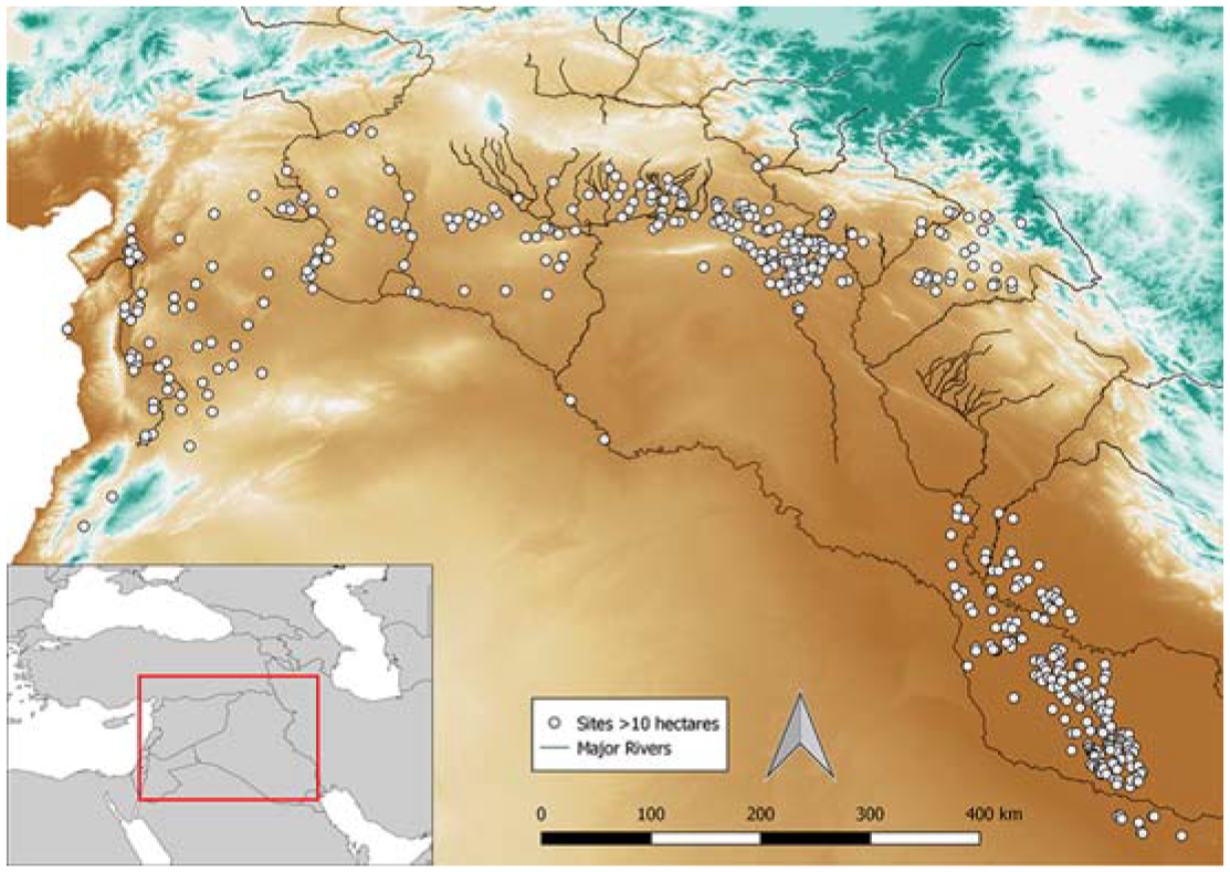
The Fertile Crescent, including the distribution of sites used in this study. Inset map shows the location of study area and modern nation state borders.
Defining the urban in the past is contentious. As in the present, definitions centred on specific population and density thresholds do not capture the diversity of urban forms, and formal boundaries risk underplaying their social and spatial reach (Brenner and Schmid, 2014; Hawken and Fletcher, 2021). Most archaeological definitions emphasise the relational aspect of urbanism, still highlighting large and dense populations and functional differentiation, but in comparison with other sites in the local settlement network (Gaydarska, 2016; Smith, 2020). Here we include all settlements over 10 hectares within our dataset. This is an order of magnitude larger than the modal site size during most of the study period, and fluctuations in the numbers of sites of this scale differ from those of smaller sites over time (Lawrence and Wilkinson, 2015; Lawrence et al., 2021; Wilkinson et al., 2014). Functional differences are more difficult to access archaeologically, and there is limited evidence for them prior to 6000 BP. Earlier sites are generally small, with a ceiling of around 20 ha. The very earliest settlements in our dataset predate the widespread adoption of agriculture, while those from the later part of the Neolithic onwards (c. 8000 BP) might best be thought of as agrotowns (Lawrence and Wilkinson, 2015), in which the vast majority of the active population worked in agricultural settings. However, we include all types here because they clearly did support unusually large populations. Comparing large settlements across the period during which functional differences between rural and urban sites emerged also allows us to assess the impact of these differences on persistence.
After 6000 BP, most urban sites are over 20 hectares, and are associated with large scale public architecture, such as temples, palaces and defensive walls, and evidence for bureaucracy, administration and long-distance trade networks which are not generally found at smaller sites. Zooarchaeological data has also revealed differences in animal exploitation between large and small sites from the earliest phases of urbanisation (Gaastra et al., 2021; Zeder, 1991), suggesting animal provisioning systems were integrated to provide cities with access to meat and secondary products.
Many of these sites have been the focus of more or less systematic investigation, through archaeological survey and excavation, for the past two centuries, meaning we have relevant evidence for a large number. This allows us to address contingency and agency in settlement development and decline. Individual sites were abandoned or moved due to a myriad of factors, such as local natural disasters or destruction during warfare. While we cannot take this into account directly, we can achieve greater experimental control through a large sample size (Ortman, 2019). By stratifying the sample across different variables we can identify systemic patterns in persistence and sustainability. We use two variables to assess three different research questions, each of which relates to themes in urban sustainable transitions research (Loorbach et al., 2017). Firstly, we use a model of land use developed for the PAGES Landcover6k project (Morrison et al., 2021) to examine the relationship between local productivity potential, and therefore ecological boundaries and energy capture, and settlement persistence. Secondly, by comparing between the highly managed irrigated landscapes of Southern Mesopotamia and dry farming Northern Mesopotamia, we can examine the effect of large scale landesque capital investment, and the attendant path dependency and sunk costs, on persistence. Finally, we examine persistence over time. The temporal coverage of our dataset spans from the beginning of the Holocene (11,700 BP) to 2000 BP. We exclude the last two millennia because this period covers the foundation of almost all cities currently occupied in our study region, for which we have no end date, and because the Classical and Islamic periods saw a very large number of urban foundations which have received limited archaeological attention. Over the study period we see a general trend towards larger and more hierarchical social and political forms, increased technological capacity and longer supply chains. We therefore use time as a broad proxy for social complexity. Note that we do not see this process as either linear or unidirectional; there were certainly periods when social complexity declined from preceding periods. However, at a millennial scale we can see increases in the sizes of sites (Lawrence et al., 2016) and political entities (Inoue et al., 2012; Korotayev et al., 2017), the scales of landscape interventions (Wilkinson, 2003; Wilkinson and Rayne, 2010), the spatial and institutional extent of economic integration (Benati et al., 2021) and levels of inequality (Basri and Lawrence, 2020).
Materials and methods
Smith et al. (2021) identify four types of settlement persistence, including persistence of occupation, persistence of demographic scale, persistence of institutions and persistence of cultural practices. Here we use a combination of the first two of these because they are the most straightforward to align with our archaeological datasets. Information on occupation length is derived from material culture, generally ceramics, recovered from sites that can be linked to established regional chronological sequences and radiometric dating. Reliance on ceramic phases presents two limitations. Firstly, we cannot identify short periods of abandonment which occurred within a single phase, and secondly the temporal length of phases tends to shorten over our study period as changes in material culture become more frequent. The latter point means we gain resolution over time and can therefore identify abandonments which may have been masked by longer phase lengths in earlier periods. Demographic scale is inferred from site size estimates, which are themselves based on the spatial extent of identifiable material scatters, again predominantly ceramics, or systematic excavations. We have excluded sites, including some well-known cities, where empirically based size estimates were not available. Our dataset is based on information extracted from a published archaeological survey and excavation reports for all sites which reach a size larger than 10 ha within the study region, building on previously published datasets (Lawrence et al., 2016, 2021).
Over our study period (12,000–2000 BP), individual sites show a variety of different trajectories, including gradual growth and decline, but also rapid changes in size, and periods of abandonment followed by reoccupation. For this paper we are interested in persistence as a significant population centre rather than, for example, low intensity settlement in the abandoned ruins of an urban site, so persistence of demographic scale is important as well as simple occupation. As a result, if a site was abandoned and then reoccupied, we count this as a new settlement and reset the persistence clock. This approach is the most parsimonious way of dealing with the data at hand, but does risk missing the significance of reoccupation, and the persistence of place despite a hiatus in settlement. The presence of a large supply of building material, repairable infrastructure such as canals, and even ritual and religious significance, may have meant abandoned centres were more favoured settlement locations than virgin land. However, the lengths of abandonment periods (usually several hundred years) mean factors commonly associated with more recent settlement persistence, such as property rights (e.g. Nygaard and Meen, 2013), are unlikely to be relevant in this case. Our approach also does not capture fluctuations in site size where a site remains over 10 ha throughout. For some sites these can be substantial – Tell Brak in Syria, for example, expanded from 55 to 130 ha during the Late Chalcolithic before falling back to 40 and expanding again to 120 ha in the Early Bronze age (Ur et al., 2011). Shifts of this magnitude are likely indicative of significant population changes, and are therefore of interest in debates about sustainability. However, gathering this information requires detailed and targeted fieldwork which has not been conducted at the vast majority of sites in our region. Here we focus on gathering the largest possible dataset of large centres in order to generate robust conclusions, and will address the examination of site size and size fluctuations as variables in a future publication. Our final dataset consists of 497 individual sites and 689 separate occupation durations (Figure 1, full dataset available in online Supplemental Material 1).
Potential productivity was defined using the land use classification system and descriptive variables devised for the LandCover6k project (Morrison et al., 2021), based on a range of data sources, models and assumptions. These include modern elevation and slope, modern soil depth and modelled past average annual precipitation data. We also model the extent of irrigated agriculture in Southern Mesopotamia, where large-scale water management was necessary for cultivation and may have been present from as early as 8500 BP (Altaweel et al., 2019). Further details and full references are available in online Supplemental Material 2. It should be noted that the resulting maps (Figure 2) are not intended to be accurate depictions of land use at any point in the past, since the latter would be affected by many other factors, such as settlement organisation and density and agricultural strategies. Rather these maps should be conceived of as reasonable large-scale spatial approximation of potential productive capacity, and a useful heuristic device for interpreting archaeological datasets.
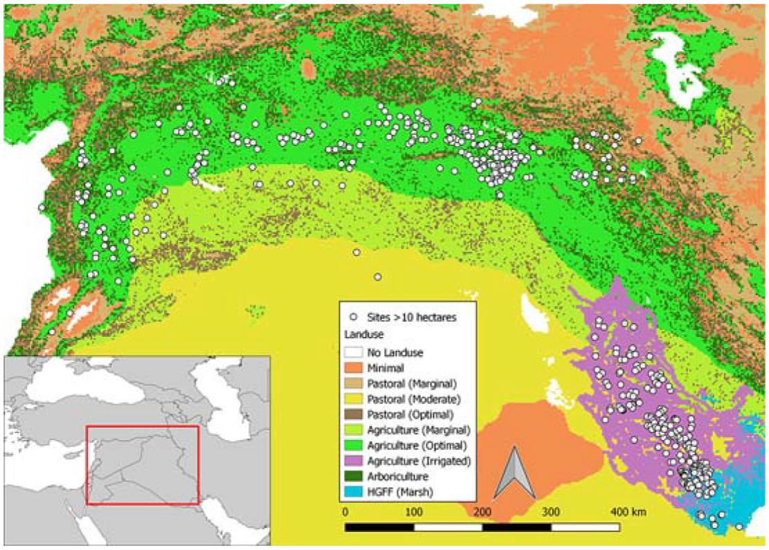
Distribution of land use zones across the study region c. 7000 BP. Inset map shows the location of the study area and modern nation state borders.
Results
We first compare simple counts and densities (counts per km2) of sites by land use zone (Figure 3). Large centres are clustered in the more fertile zones, particularly Agriculture Optimal and Agriculture Irrigated, while there are fewer sites in the Arboriculture zone. The high density of sites in the Marsh zone is likely the result of changes in the location of the interface between the Marsh and Irrigated zones in Southern Mesopotamia over time. There is some debate as to the relative importance of marshland and irrigated cropland in the emergence of urban sites in this region (Altaweel, 2019; Jotheri et al., 2018; Pournelle, 2003), and the extent of marshland at any given time (Hritz et al., 2020; Jotheri and Allen, 2020). Our land use reconstructions are too coarse to fully capture this complex mosaic of environments, especially as it changes over time, meaning sites may be misallocated between the Marsh and Agriculture Irrigated categories. Except for the earliest phases, we would expect most sites to be predominantly dependent on irrigated cropland rather than marsh resources (Scott, 2017). Taken together, these three zones account for 591 site phases within our dataset of 689, and have the highest settlement densities. The line between these more fertile areas and the less fertile is stark, with all land use zones from Agriculture Marginal through the different categories of Pastoralism (Optimal, Moderate and Marginal) to Minimal land use supporting extremely small numbers of sites. The raw counts are hard to interpret here due to the large differences in the total area of the different zones within the study area. However, the densities demonstrate there is still a trend of decreasing numbers of sites as productive capacity decreases, even within these small numbers.
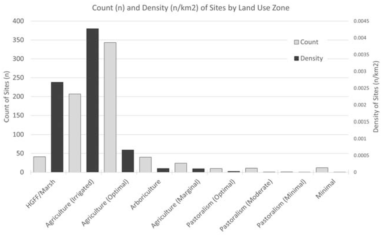
Histogram of site counts and densities by land use zone.
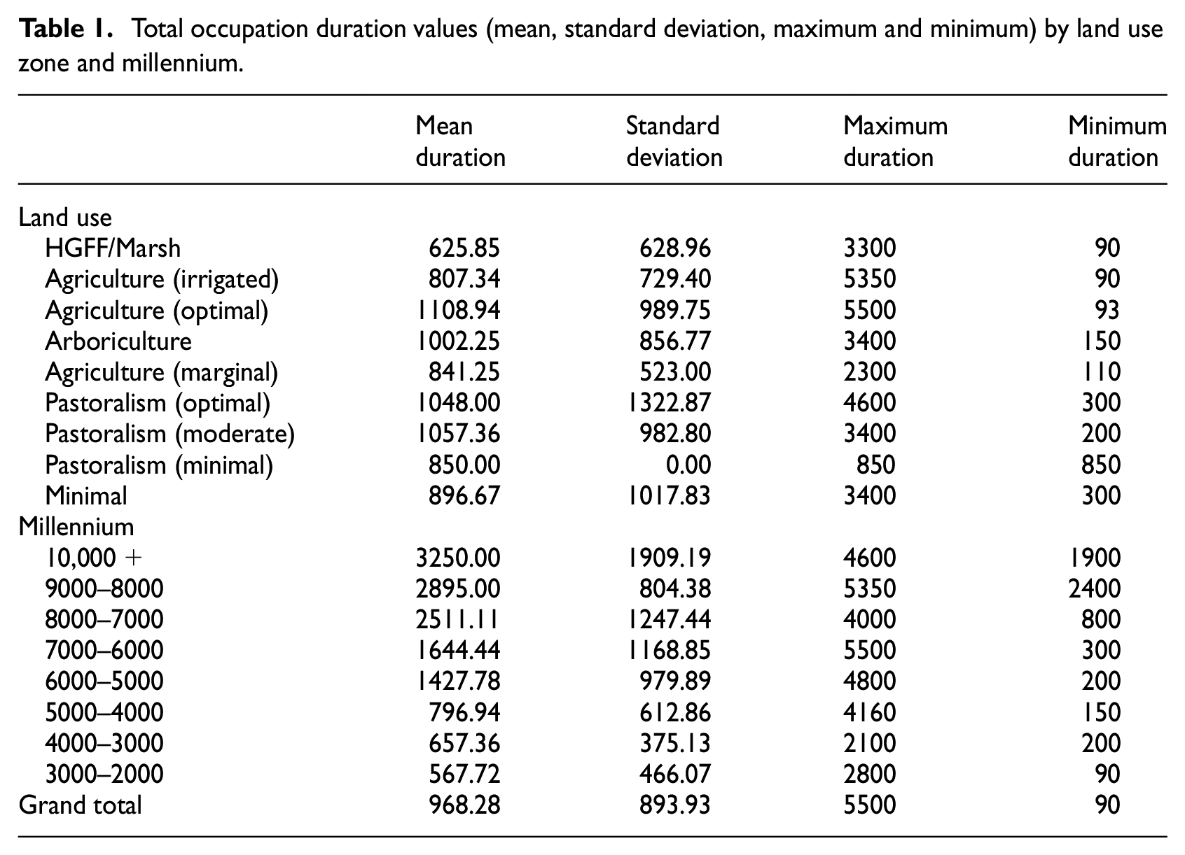
The relationship between land use zones and persistence does not show the same levels of differentiation as the counts, and also exhibits a rather different trend (Figure 4, Table 1). The highest mean duration is found in the Agriculture Optimal zone, but the densely occupied Agriculture Irrigated and Marsh zones have the two lowest mean durations, with Marsh particularly low, despite several very long-lived outliers. The Optimal and Moderate Pastoralism zones have high mean durations, with Arboriculture also relatively high. In contrast to the clear divide between the most fertile categories (Agriculture Optimal, Agriculture Irrigated and Arboriculture) and the rest visible in the counts and densities data, we identify two groups in the persistence results which do not align with agricultural productivity. The first group is those with high levels of persistence, and includes the Agriculture Optimal and Arboriculture zones, but also the less fertile Pastoralism Optimal and Moderate zones which have high means with wide interquartile ranges (likely due to the small numbers of sites). The second group has lower levels of persistence and includes the less fertile Agriculture Marginal and Pastoralism Minimal, and Minimal land use, zones, but also the highly fertile Agriculture Irrigated and Marsh zones, with the latter two having the lowest average durations of all the zones.
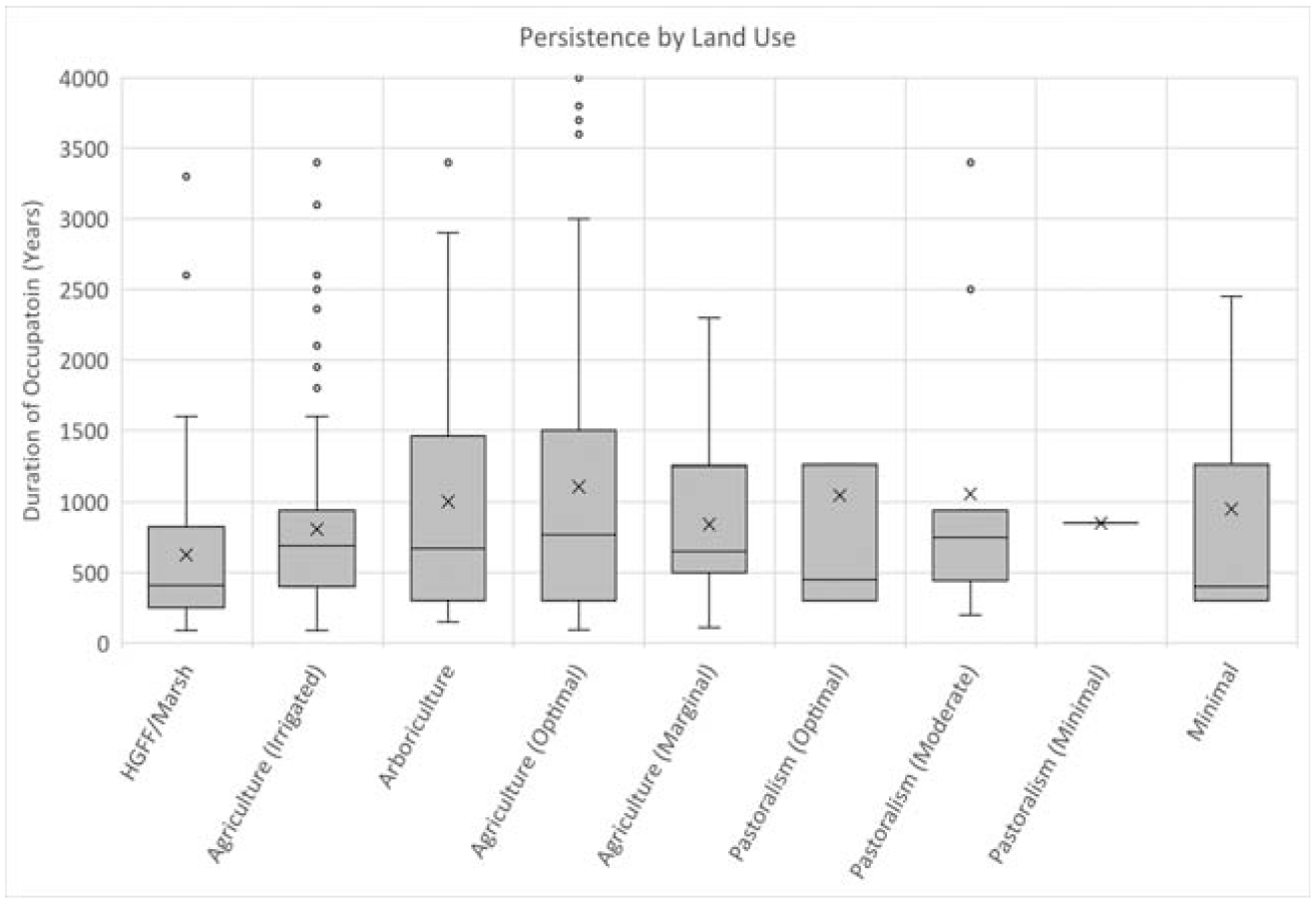
Boxplot of total occupation lengths (persistence) by land use zone.
Total occupation duration values (mean, standard deviation, maximum and minimum) by land use zone and millennium.
We can also see patterns in both counts of sites and persistence over time. Figure 5 shows the number of sites founded by millennia across the study period. Two trends are visible, firstly a general increase over time, with exceptions at 9000–8000 and 4000–3000 BP, and secondly a jump in site numbers at 6000 BP. The latter captures the urban revolution in both Northern and Southern Mesopotamia. The higher count at 9000–8000 BP coincides with a period of settlement reorganisation and expansion, while settlements over 10 ha remained small, with none exceeding 20 ha.
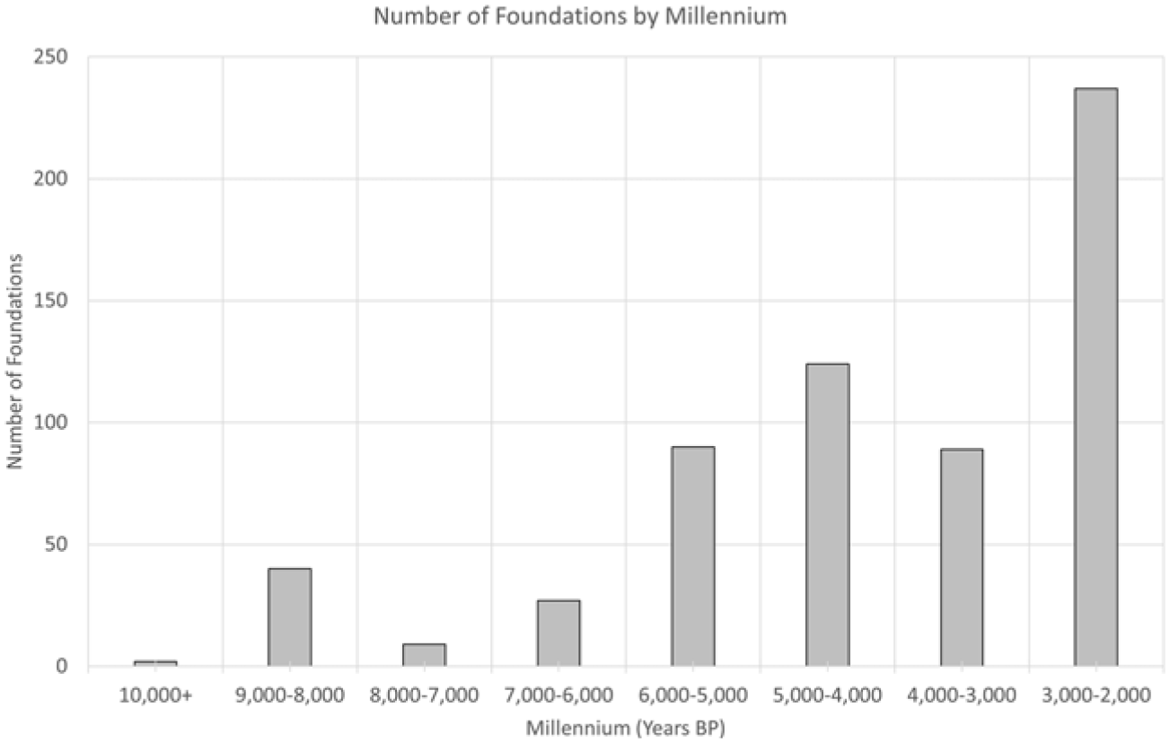
Histogram of site foundations by millennium.
In the persistence data, the clear trend is decreasing mean persistence and interquartile range over time, with 6000 BP again representing a transition point (Figure 6). The very long average durations prior to 8500 BP likely reflect phase lengths associated with dating by stone artefacts rather than ceramics, while changes in ceramic traditions are slower in the phases between 8500 and 6000 BP than afterwards. Given these issues we should be cautious in overinterpreting these data. However, it does seem to be the case that the urban revolution also has an impact here, with decreased average persistence from 6000 BP onwards, and a downward trend across the last four millennia of the study period. This suggests that the emergence of complex urban centres, that is those that likely had functional differences from smaller sites, and of increasingly large and complex polities in the following millennia, coincide with a decline in settlement persistence.
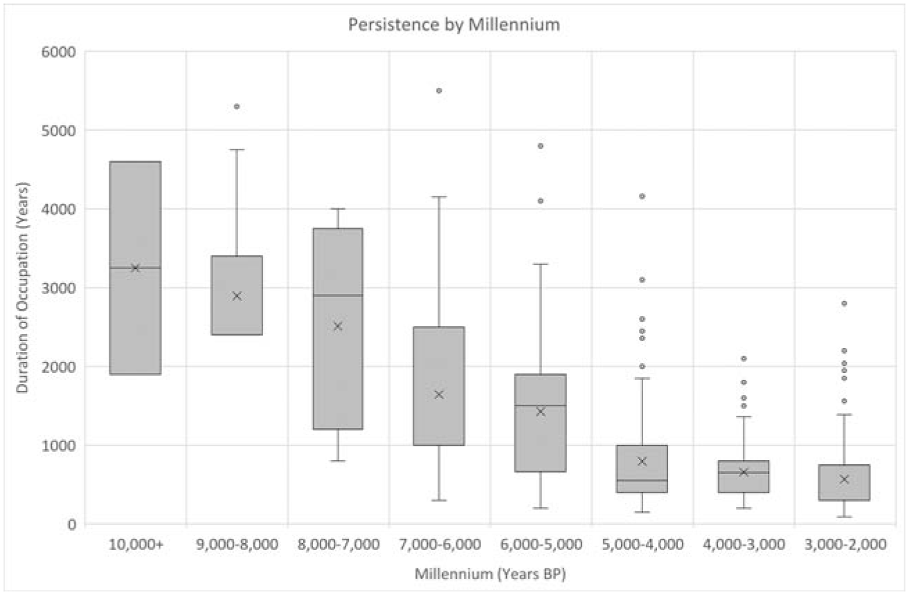
Boxplot of total occupation lengths (persistence) by millennium.
Discussion
Our results demonstrate that examining differences in the persistence of large settlements across land use zones and over time can add to our understanding of past sustainability, especially in combination with conventional metrics used in archaeology, such as site densities. Returning to the research questions laid out in the introduction, we can say that there are differences between settlement persistence across land use zones, but there is no direct correlation between local productivity and persistence. Both raw counts and densities of settlements correlate with agricultural productivity, with irrigated agricultural regions (including marshland in our reconstruction) the most densely occupied, followed by well-watered regions suitable for dry farming, and a rapid fall off to very low numbers of settlements in more arid zones. We might expect high levels of persistence in the irrigated landscapes of Southern Mesopotamia as the reliance on capital intensive infrastructure such as canals locked-in settlements to specific landscape configurations. Conversely, Northern Mesopotamia is characterised by relatively undifferentiated plains which could be productive wherever rainfall is sufficient, meaning fewer constraints on settlement location, and therefore lower penalties for settlement abandonment. This is not borne out in the data, as the irrigated and marshland environments have lower levels of persistence than those in productive dry farming regions. This disparity can be explained through our second research question, on the role of landesque capital investment. Here we would argue that it is not the presence or absence of investment that is critical, but the scale and organisation required. Farmers in Northern Mesopotamia enhanced productivity through manuring, and likely small scale water management, from at least the Neolithic period (Styring et al., 2017), but this could be organised at a household level. By contrast, water management in Southern Mesopotamia was of such a scale that it required the mobilisation of significant labour forces. Textual sources evidence fluctuating degrees of political control and state intervention from the third millennium onwards (Rost, 2017) but some form of organisation and management would have been necessary, even in periods without direct state involvement. Large scale irrigation was also reliant on specific hydrological regimes within the dynamic landscapes of the southern alluvium, with channel silting, salinisation and river avulsions all common problems (Adams, 1981; Jacobsen and Adams, 1958). Irrigation brought about a degree of path dependency, due to the sunk costs involved in the construction of particular configurations of canals, agricultural fields and settlements, but it also meant even minor changes in environmental conditions and social organisation could have major effects. Dependence on specific environmental and political conditions may have increased vulnerability and thereby decreased overall levels of persistence in comparison with the North, where large scale landscape management was not common in the more productive zones until the very end of our study period (Lawrence et al., 2017; Wilkinson and Rayne, 2010).
A further counter-intuitive outcome is that highly persistent sites are found in the more marginal environments such as Pastoralism Moderate and Minimal, although the sample size is small. It is possible that the limited locations suitable for settlement in these areas mean that, once established, sites are more likely to survive for long periods. Such sites may have exploited local ecological niches and water management strategies which are not picked up by our low-resolution land use reconstruction. Furthermore, the effort required to sustain settlement in these areas suggests these sites exist for a reason, perhaps to exploit local resources unavailable elsewhere, or as transport hubs. Several of the settlements in this category, such as Mari and Terqa, are located along the Euphrates River, and were in a position to control long distance trade networks. The low settlement persistence in the Agriculture Marginal zone is noteworthy. This category encompasses what Wilkinson et al. (2014) have defined as the Zone of Uncertainty, an area where cereal agriculture was possible but with increased risk of crop failure. Here we see a pattern of boom and bust, with sites founded in relatively large numbers in response to new technologies and economic opportunities, but very low persistence over the long term. The two major incursions within our study period occurred during the Early Bronze age, when demand for textiles facilitated a system of agro-pastoralism (Lawrence et al., 2021; Wilkinson et al., 2014), and during the last millennium, when the major territorial empires were able to put in place large scale canal systems on several major rivers (Wilkinson and Rayne, 2010). In the first case a combination of landscape degradation and climate change curtailed settlement while in the second political instability meant these canal systems were abandoned soon after they were put in place.
As noted above, the trend visible in the temporal data towards lower levels of persistence through time should be considered with caution due to changes in the precision of dating across the study period. However, if this trend is real then the implications are profound, because it suggests that sustainability is inversely correlated with social complexity. As noted above, increases in social complexity were not uniform, either temporally or geographically, across our study region and period, and were punctuated by periods of decline, but at a millennial scale we can see a general direction of travel. These results support Tainter’s argument that the increased management of natural systems requires increased problem-solving capacities, and therefore complexity, but that this comes at a metabolic cost with diminishing returns over time, leading to declines in sustainability (Tainter, 2003; Tainter and Allen, 2015). Here, the deep time perspective offered by archaeological and historical understanding allows us to identify the effects of seemingly beneficial actions, such as raising productivity through irrigation and complex organisation, as damaging to sustainability at a millennial scale (Costanza et al., 2007). Interestingly, our persistence results contrast with studies examining sustainability and resilience through the relationship between climate change and population in this region. In the first half of the Holocene, population is reasonably well correlated with aridity, with wetter periods resulting in greater productivity and higher populations. However, during the second half of the Holocene, climate and population become decoupled, with generally increasing aridity at the same time as population expansion (Palmisano et al., 2021; Roberts et al., 2019). These changes have been explained in the light of changing adaptive capacities due to more complex forms of organisation and management of resources (Roberts, 2021) including labour. Although this may be true of overall population levels, it seems that for the sites included in our sample, greater complexity had a negative impact on persistence. We might distinguish between drivers for systemic sustainability as compared to those required for individual entities (sites) within the system (Lenton et al., 2021). It is possible that the ability to move large, settled labour forces between urban sites without losing the productive and institutional capacities required to provision them was part of the adaptive advantage of later complex societies.
Conclusion
Developing sustainable urban systems is widely recognised as vital for the future of humanity, and is at the heart of the New Urban Agenda (United Nations Habitat, 2017) and Goal 11 of the 2030 Agenda for Sustainable Development (United Nations, 2015). Archaeology can contribute to our understanding of sustainability because it offers a rich archive of completed experiments; cities, communities and societies which have experienced different degrees of success, sometimes over millennia. Here we have used persistence of a settlement over time as a measure of sustainability. Our results demonstrate clear patterns in persistence across different land use zones and over time, allowing us to identify factors which facilitate sustainability. We find that settlements with the highest levels of persistence were not always associated with high productivity, and long lived sites are located in some of the most marginal landscapes, likely at critical points in transport and exchange networks. We also find that persistence is enhanced in landscapes which do not require large-scale capital investment or specific forms of economic and social organisation to maintain high levels of agricultural productivity. Together with the millennial scale comparisons, which demonstrate a decline in persistence over time, we speculate that increases in the complexity of social organisation and landscape management are causally linked to declines in sustainability. This is sobering given we currently live in the most complex and environmentally interventionist societies ever to have existed. However, the evidence from Northern Mesopotamia suggests dense networks of urban settlements could persist, and within the dataset as a whole we see individual long-lived settlements in all landscape zones. Understanding the factors behind this longevity will require bringing in further variables. An analysis of persistence patterns in Japan noted the importance of physical geography as a determining factor (Davis and Weinstein, 2002), and recent work has identified the role of natural trade routes in long term trends in urban size in Anatolia (Barjamovic et al., 2019). Future work could compare persistence across a wider range of geographic factors, and investigate relative position within networks, and general network effects, at a range of scales. Other potential avenues include comparisons across settlement size ranges to identify how agglomeration effects impact persistence, using more nuanced metrics for social complexity to explore the patterns identified here, and even using textual sources to investigate factors such as religious or cultic importance. By leveraging the long-term view of past socio-ecological systems available to archaeologists (van der Leeuw and Redman, 2002) we can identify the causal factors which facilitated sustainability at a millennial scale.
Supplemental Material
sj-xlsx-1-usj-10.1177_00420980231161245 – Supplemental material for Long-term trends in settlement persistence in Southwest Asia: Implications for sustainable urbanism, past, present and future
Supplemental material, sj-xlsx-1-usj-10.1177_00420980231161245 for Long-term trends in settlement persistence in Southwest Asia: Implications for sustainable urbanism, past, present and future by Dan Lawrence, Michelle W de Gruchy, Israel Hinojosa-Baliño and Abdulameer Al-Hamdani in Urban Studies
Supplemental Material
sj-docx-2-usj-10.1177_00420980231161245 – Supplemental material for Long-term trends in settlement persistence in Southwest Asia: Implications for sustainable urbanism, past, present and future
Supplemental material, sj-docx-2-usj-10.1177_00420980231161245 for Long-term trends in settlement persistence in Southwest Asia: Implications for sustainable urbanism, past, present and future by Dan Lawrence, Michelle W de Gruchy, Israel Hinojosa-Baliño and Abdulameer Al-Hamdani in Urban Studies
Supplemental Material
sj-docx-3-usj-10.1177_00420980231161245 – Supplemental material for Long-term trends in settlement persistence in Southwest Asia: Implications for sustainable urbanism, past, present and future
Supplemental material, sj-docx-3-usj-10.1177_00420980231161245 for Long-term trends in settlement persistence in Southwest Asia: Implications for sustainable urbanism, past, present and future by Dan Lawrence, Michelle W de Gruchy, Israel Hinojosa-Baliño and Abdulameer Al-Hamdani in Urban Studies
Footnotes
Acknowledgements
We thank the editors of this special issue for discussion and three anonymous reviewers for comments, all of which substantially improved the final paper. This article is dedicated to our colleague and co-author, Dr Abdulameer Al-Hamdani, who sadly passed away during its preparation.
Declaration of conflicting interests
The author(s) declared no potential conflicts of interest with respect to the research, authorship, and/or publication of this article.
Funding
The author(s) disclosed receipt of the following financial support for the research, authorship, and/or publication of this article: This research was supported by the European Research Council under the European Union’s Horizon 2020 research and innovation programme for the project ‘CLaSS – Climate, Landscape, Settlement and Society: Exploring Human Environment Interaction in the Ancient Near East’ (grant number 802424, award holder: Dan Lawrence).
Supplemental material
Supplemental material for this article is available online.
References
Supplementary Material
Please find the following supplemental material available below.
For Open Access articles published under a Creative Commons License, all supplemental material carries the same license as the article it is associated with.
For non-Open Access articles published, all supplemental material carries a non-exclusive license, and permission requests for re-use of supplemental material or any part of supplemental material shall be sent directly to the copyright owner as specified in the copyright notice associated with the article.