
Abstract
Environmental hazards affect people from different income groups and migration backgrounds on different levels. The research on environmental inequalities and environmental justice has proposed several theories to explain such inequities; still, it remains unclear which of these theories applies to the German societal context. This research investigates whether individual-level income differences between Germans and migrants account for objectively measured exposure to the environmental goods and bads of land use, specifically soil sealing and green spaces. Marginal effects and predictions based on georeferenced survey data from the German General Social Survey reveal that Germans with higher incomes live in areas with better neighbourhood quality. Germans with lower incomes are exposed to fewer disadvantages stemming from land use, and there is no marginal difference between nonurban and urban municipalities. Spatial assimilation in high-income groups occurs; however, the difference in low-income groups can be explained by place stratification and discrimination in the housing market. While this study uses more indirect and non-hazardous measures of environmental quality – in contrast to air pollution or noise – it provides evidence that such indicators also create distributional injustices in Germany.
Introduction
While environmental hazards deriving from industry emissions have been steadily decreasing over recent decades in Germany (Federal Agency for the Environment Germany, 2015), disadvantages originating from land use and urbanisation, such as soil sealing or a lack of recreational green spaces, are continually growing. These disadvantages not only involve environmental issues but also give rise to societal questions concerning residential segregation and inequality, mainly because they impact individual well-being (Gidlöf-Gunnarsson and Öhrström, 2007), stress processing (Thompson et al., 2012) and physical (Schulz et al., 2016) and mental health (Guite et al., 2006). Researchers who have investigated the social and spatial inequalities of local environmental goods and bads have found that disadvantages are more likely to affect people of low socioeconomic status and members of ethnic minorities than those of high socioeconomic status and members of ethnic majorities (Ash and Fetter, 2004; Braubach and Fairburn, 2010; Rüttenauer, 2018; Wolch et al., 2014).
However, there are two reasons why the previous findings on environmental inequalities – gathered mostly within the US context – cannot be directly applied to the German societal context. First, the residential segregation structures of Germany and other countries, such as the US, the UK or the Netherlands, differ. Ethnic residential segregation in Germany is not as strongly concentrated as in other societies with large urban neighbourhoods established around homogeneous ethnic backgrounds (Schönwälder and Söhn, 2009). Second, we know little about individual-level residential segregation in Germany due to a lack of data (Goebel and Hoppe, 2015), especially with regard to environmental inequalities. Accordingly, findings on microlevel environmental inequalities in Germany have been rare (some exceptions are e.g. Best and Rüttenauer, 2018; Braubach and Fairburn, 2010) or have lacked in-depth investigation with objective data on a small geographic scale.
This article aims to close this gap by studying the unequal distribution of environmental goods and bads, considering migration backgrounds and income in Germany. It uses cross-sectional survey data from the general population combined with smallscale spatial data on land use. This unique dataset allows us to assess environmental inequalities regarding soil sealing and access to green spaces. Does potential distributional injustice stem from ethnic income inequalities? While the analysis cannot infer causal relationships because, for example, income might also be confounded by personal traits, it demonstrates crucial pathways for further investigations into environmental inequalities in Germany.
Background
The research on environmental inequalities often addresses direct hazards to health and well-being such as environmental noise (Dreger et al., 2019) or air pollution, for example through industry emissions (Glatter-Götz et al., 2019; Rüttenauer, 2018). More indirect measures address the general quality of the neighbourhoods in which people live (Lersch, 2013; Swope and Hernández, 2019; Vaalavuo et al., 2019). What has been emerging in recent years are studies of beneficial environmental factors; more specifically, green spaces. Multiple studies have emphasised that access to such areas can reduce stress and increase well-being (Huang et al., 2020; Mizen et al., 2019; Thompson et al., 2012). Both hazards and beneficial factors are conceptualised as environmental goods and bads.
This study concentrates on the environmental goods and bads stemming from land use. Land use refers to the built environment, which is defined as ‘human-made or modified surroundings, such as buildings, land use (e.g. layout of communities, transportation systems, food infrastructure) or green spaces’ (Schulz et al., 2016; emphasis mine). This definition of land use shows that it can provide life chances in certain areas while reducing them in others by harming people. This study uses data on soil sealing (the air- and water-tight coverage of soils) and green spaces. When we interpret the latter in terms of a lack of access to green spaces when they are low, all data can be described as environmental disadvantages. Land use disadvantages differentiate from direct environmental hazards but still render theories of environmental inequalities applicable (Baró et al., 2019; Kabisch and Haase, 2014; Rigolon et al., 2019).
Income, minority background and environmental inequalities
The research has shown that economically disadvantaged neighbourhoods are more often affected by environmental disadvantages than wealthy ones (Banzhaf et al., 2019; Williams et al., 2020). Income plays an essential role in the housing market by determining how much people can afford to buy or rent properties. To this day, after decades of research in the US (Banzhaf et al., 2019), we find that low-income or disadvantaged households also experience more environmental disadvantages in other regions of the world (de Vries et al., 2020; Sikorska et al., 2020).
Similarly, we find evidence for societies’ minorities being more exposed to environmental disadvantages than the majorities. Studies with both aggregated data and individual-level data have revealed that foreign-born people or those whose parents were foreign-born experience more pollution (Best and Rüttenauer, 2018; Crowder and Downey, 2010; Diekmann and Meyer, 2010; Raddatz and Mennis, 2013), environmental noise (Collins et al., 2020) or multiple exposures at once (Flacke et al., 2016; Klompmaker et al., 2020). For example, Glatter-Götz et al. (2019) reported that the risk of living near industry facilities in Austria is twice as high for immigrants than for the majority population. Regarding the provision of green spaces, the findings have been ambivalent, with some supporting the conclusions of ethnic inequalities in urban tree provisions (Namin et al., 2020), some rejecting them (Baró et al., 2019) and others finding more green spaces in areas with high immigrant rates (Mears et al., 2019).
One explanation for the income effect is income inequalities, whereas for the minority effect, discrimination on the housing market may be operative (Horr et al., 2018). Environmental quality increases housing prices, which is why people with higher incomes can afford to live in better neighbourhoods. However, discrimination even stops minorities with higher incomes from living in such places. Naturally, previous studies have already assessed both factors in their combined effect (Zwickl et al., 2014); however, evidence for the German case is missing. In the following, two theories are presented – spatial assimilation and place stratification – to explain such ethnic income inequalities while considering alternative explanations.
Spatial assimilation, place stratification and different preferences
Spatial assimilation theory claims that households choose their neighbourhoods based on their social status and life course. Accordingly, if households move, they move to neighbourhoods where other households’ social status is similar, for example in the form of income. Alternatively, from the life course perspective, if income increases, households move to neighbourhoods that match their new social status (South et al., 2016). Generally, spatial assimilation describes the phenomenon whereby minority populations in a society gradually adopt the majority’s spatial patterns, and one vehicle in achieving that is income.
In the context of environmental inequalities, the socioeconomic inequality and the ethnic income inequality thesis apply this idea of spatial assimilation (Crowder and Downey, 2010). The socioeconomic inequality thesis builds on the observation that housing prices increase with higher environmental quality. When households have higher incomes, they can afford to live in neighbourhoods with fewer environmental disadvantages. The ethnic income inequalities thesis highlights differences in exposure often found between members of the majority and the minority populations. However, this inequality is due to income differences. If migrants in Germany, for example, reach similar incomes to those of Germans, they sort into neighbourhoods that are less exposed to environmental disadvantages.
Place stratification theory, in contrast, assumes that environmental inequalities do not dissolve with similar levels of income. Members of certain groups, such as migrants, are constrained in moving to better neighbourhoods as they depict life chances governed by the majority population. Constraints can be imposed by discrimination in housing markets (Auspurg et al., 2017; Schönwälder and Söhn, 2009), which systematically drives migrants into neighbourhoods exposed to environmental disadvantages, independent of their income. An indissoluble connection between discrimination and residential segregation (Dill and Jirjahn, 2014) explains why migrants are more exposed to environmental disadvantages.
Differentiating between a ‘weak’ and a ‘strong’ version of the theory proposed by Logan and Alba (1993), this connection is rendered more loose in translating income into more ‘desirable residential outcomes’ (Crowder and Downey, 2010) for ethnic minorities. What was described above is the strong version: even higher-income minority groups end up in lower-quality neighbourhoods than comparable members of the majority group due to enduring discrimination. In the weak version, discrimination in higher-income groups dissolves, increasing the marginal gain of income for minorities compared to the majority (Crowder et al., 2006).
A competing observation is that of status-independent preferences in neighbourhood choice such as age or ethnicity (Li et al., 2020). Lersch (2013) reported that people with a Turkish origin often seek to move into neighbourhoods where other Turkish people live. In contrast to different social groups, Turkish people only move to higher-quality neighbourhoods if the proportion of other Turkish people remains the same in the new neighbourhood. Moreover, Kabisch and Haase (2014) showed that Turkish people use green spaces, such as parks, differently from the native population such that other factors in neighbourhood choice can outweigh preferences of higher neighbourhood quality. Although in this study we concentrate on migration background without differentiating cultural backgrounds, considering income might not eliminate all of the observed inequalities between Germans and migrants because of different preferences.
Finally, an ongoing debate, particularly from the longitudinal perspective, is when environmental disadvantages occur in neighbourhoods. For example, are industry facilities selectively sited in neighbourhoods with high rates of migrants, or do migrants selectively move into neighbourhoods with industry facilities (Mohai and Saha, 2015)? However, these conflicting perspectives of selective siting and selective migration (Best and Rüttenauer, 2018) cannot be addressed in this study because we lack information about the moving behaviours of the survey respondents. In addition, land use disadvantages are difficult to conceptualise as hazards originating from single polluters such that, for example, only the building of industrial facilities becomes a topic of bargaining and collective action (Banzhaf et al., 2019). We test whether there is a social gradient of income and migration background affecting land use disadvantages in Germany and how spatial assimilation and place stratification contribute to its explanation.
Methods
Data
The survey data used are pooled georeferenced data from the 2016 and 2018 German General Social Survey (GGSS) (GESIS-Leibniz Institute for the Social Sciences, 2017, 2019). Both studies are population surveys based on probability samples, and pooling them makes it possible to draw on a sample of a suitable size for the analysis. The GGSS is conducted every two years as a cross-sectional study of the general population aged 18 and above among ∼3500 persons with similar sample sizes and harmonised sociodemographic variables. Overall, we use information from 6117 respondents.
The small-scale geospatial data are from the Monitor of Settlement and Open Space Development (IOER Monitor) compiled by the Leibniz Institute for Ecological Urban and Regional Development (IOER) (IOER, 2019). The data’s geographic extent consists of uniformly shaped, 100 m × 100 m (1 hectare) grid cells. These data provide information on land use and its development for the whole of Germany for recent years, which have been gathered, in the case of the indicators used in this study, with aerial photography (Grunewald et al., 2019). All indicators comprise land use in percentages of 1-hectare grid cells. In combination with survey data, they depict individual land use disadvantages that, for example, originate from a lack of green spaces.
The survey data are spatially linked with indicators from the IOER Monitor based on the respondents’ location geocoordinates also referring to 1-hectare grid cells. A multistep procedure described in Schweers et al. (2016) ensures that, in compliance with German data protection legislation, during the spatial linking, no respondents’ geocoordinates are compounded with the actual survey data. The geospatial indicators are added by building buffer zones of 500 m around the survey respondents’ locations and calculating their mean value. The 500-m distance should represent a decent approximation of an ‘effective neighbourhood’ (Spielman and Yoo, 2009) since we can expect that, even for older people, 500 m constitutes walking distance. Analyses based on alternative buffer zones, for example 1000 m, are part of the Supplemental Material; however, they do not differ greatly from the results provided here.
Measures
Dependent variables: Soil sealing and green spaces
Soil sealing is the air- and water-tight coverage of an area by buildings and traffic areas. In addition to its immediate impact on the environment, it is an indicator of neighbourhood quality. For example, areas with high amounts of soil sealing have fewer recreational green spaces. Accordingly, soil sealing can be defined as a land use disadvantage because of a lack of green spaces.
To corroborate soil sealing as an inverse measure of a lack of recreational areas, we include a direct green space indicator. However, green spaces in parks, sporting areas or gardens are prevalent in urban areas, whereas in non-urban areas open spaces directly border settlement areas. Fortunately, in the IOER Monitor, these two indicators of green (urban-type) and open (non-urban-type) spaces are exclusive such that we can total them on a single scale ranging from 0% to 100%. 1 Soil sealing data were only available for 2015, whereas for green spaces we can draw on data for 2016 and 2018.
Figure 1 displays the geographic structure of the land use data on a map section of the city of Dresden and how the information was added to the survey respondents’ location via buffer zones. The dots on each layer depict a fictional survey respondent’s geolocation, whereas the circular areas on the surfaces indicate the 500-m buffer zones. The figure shows that soil sealing and green spaces are in an inverse relationship.
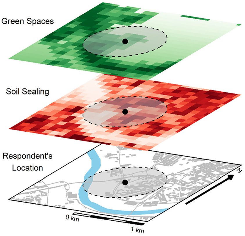
Map section of the city of Dresden, displaying the geographic structure of the indicators of soil sealing and green spaces and the size of the 500-m buffer zones.
Independent variables: Income and migration background
For income, a continuous variable is used that relies on the household income in euros (EUR), which is the money available for households after totalling the incomes of all household members in 1000 EUR steps. To adjust this measure for actual resources available for households, similar to Best and Rüttenauer (2018), the equivalised household income is computed by dividing the household income by the square root of the number of household members. In the analysis, income is non-linearly modelled by including a quadratic term to adjust the estimates for outliers and to control potential non-linearities because of increased soil sealing in city centres (see below). The variable for migration background is based on the official definition in Germany according to which persons have a migration background either if they have foreign citizenship or if one of their parents was foreign-born (for a discussion of the term, please refer to Will, 2019). Accordingly, migration background is a binary indicator that is zero for Germans and one for migrants.
Control variables
In the analysis, two more sociodemographic variables are included: age and sex. Moreover, the estimates are adjusted for several other variables that influence migration behaviour. They include the highest achieved level of education (low, medium or high) and the number of people living in the same household, as it is assumed that the household size determines the opportunities to move to certain neighbourhoods.
Finally, the analysis adjusts for variables that could confound the estimates. First, the population size of the respondents’ municipalities is controlled for because we can expect more soil sealing in more populated cities. In a subsequent robustness check, a dichotomous indicator of urbanity (fewer than 100,000 and more than or equal to 100,000 inhabitants) is calculated from this variable. Moreover, as previous research has shown in a similar sample, changes in effects between survey waves can be an artefact of heterogeneous time trends between Germany’s Eastern and Western parts (Auspurg et al., 2019). Thus, we control for interaction between survey year and region. Lastly, increased soil sealing might be found in city centres, where people require high incomes to live. Omitting centrality would bias the test of spatial assimilation. Rüttenauer (2019) used distances to town halls as an indicator of centrality in 79 German cities; however, not all municipalities in our sample have a town hall. To adjust the estimates for this vital control variable in this study, the distance to the centroid of the ZIP code area of each municipal administration is used. Since administrations tend to be located relatively centrally, they provide a proper approximation of centrality. An overview of all variables for the analysis is displayed in Table 1.
Descriptive statistics of all variables used in the analysis.
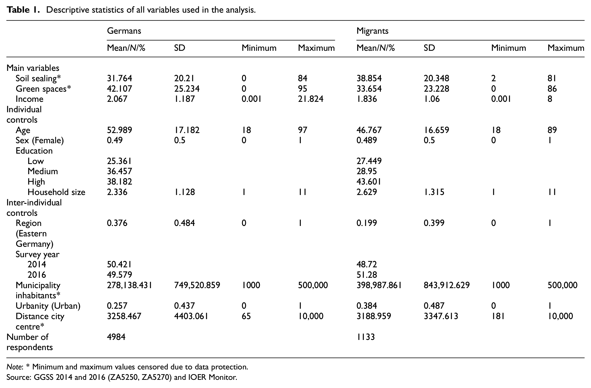
Note: * Minimum and maximum values censored due to data protection.
Source: GGSS 2014 and 2016 (ZA5250, ZA5270) and IOER Monitor.
Statistical approach
The analysis assesses land use disadvantages depending on income and migration background. Statistically, it makes sense to model this relationship using the land use indicators as dependent variables and the other two attributes as independent variables in an OLS regression. Although a regression model implies causal relationships, we are not testing whether individual-level income causally modifies land use. Instead, we estimate individual-level land use exposure by the varying characteristics of the survey respondents.
Because this model requires interaction effects, calculating average marginal effects (AMEs) can be helpful. While AMEs are best suited for regressions, for example with a logit link function, Mize (2019) and Mize et al. (2019) demonstrated that they are beneficial to compare coefficients within and between models. AMEs provide an opportunity to test the slopes for the specific ranges of a non-linear relationship by exploiting a second difference test based on the variance/covariance matrix of the estimates. Since we include a quadratic term of income in the analysis, AMEs allow for straightforward comparisons of estimates and predictions.
Finally, the regressions include cluster-robust standard errors. Different municipalities’ residential policies may produce dependencies between respondents within municipalities, resulting in inflated standard errors (Abadie et al., 2017). For example, municipal administrations implement housing market legislation, so people within the same municipality are affected by the same rules and may respond similarly to the housing market. The analysis adjusts for clustering across the sample points of the GGSS because they correspond to municipalities (N = 323).
Results
Baseline model: General environmental disadvantages exposure
What is the general association between migration background and environmental disadvantages? Table 2 displays the results of a baseline model, adding income as a control variable and interaction variable to the subsequent models. This table also contains AMEs for migration background and their inter-model differences in the lower rows. Migrants are, on average, 5.428 percentage points (pp) more exposed to soil sealing, whereas they have −6.272 pp less green space in their neighbourhood. Adding income to the estimation changes these numbers only slightly: by −0.370 pp for soil sealing and by 0.419 pp for green spaces. Nevertheless, after using the test of second differences, it is evident that they are statistically significant at a level of p < 0.001. The same holds at p < 0.1 and p < 0.05 for the differences of −0.202 pp and 0.276 pp, respectively, after adding the income interaction.
Cluster-robust regressions of the models without income, with income and with an income interaction for soil sealing and green spaces (full table in Supplemental Material).
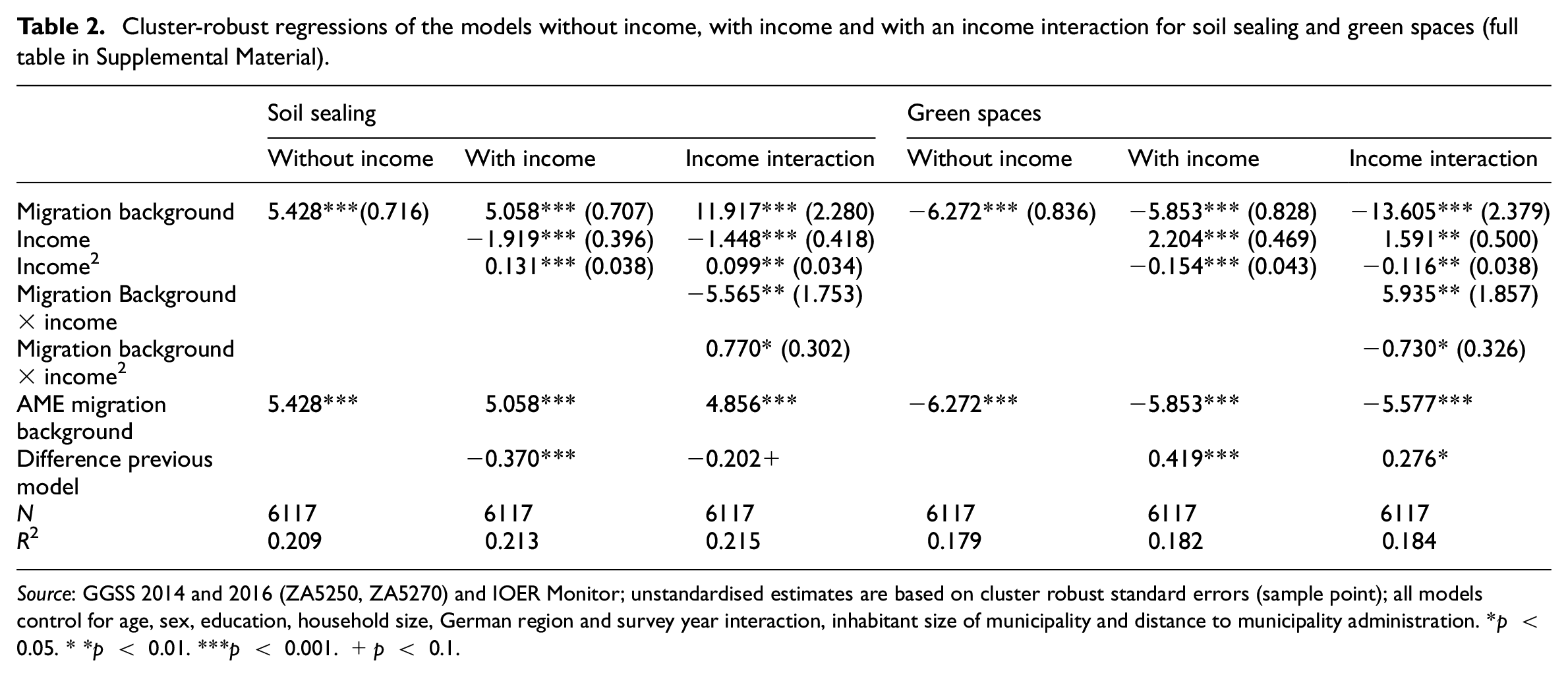
Source: GGSS 2014 and 2016 (ZA5250, ZA5270) and IOER Monitor; unstandardised estimates are based on cluster robust standard errors (sample point); all models control for age, sex, education, household size, German region and survey year interaction, inhabitant size of municipality and distance to municipality administration. *p < 0.05. **p < 0.01. ***p < 0.001. +p < 0.1.
While income leads to a statistically significant reduction in the AME of migration background, we cannot infer a great benefit of income concerning land use disadvantages. However, based on this first inspection, it cannot be tested whether spatial assimilation might hold. The following analysis aims to uncover this aspect by estimating predictions across the range of incomes.
Land use disadvantages as a function of income
How does income relate to the differential land use disadvantages of Germans and migrants? By predicting soil sealing and green spaces with varying income levels and holding all other predictors at their empirical values, patterns of possible relationships are revealed. Figure 2A shows the results for soil sealing. It consists of one plot on the left for the prediction with the value of soil sealing on the Y-axis and income on the X-axis and 95% confidence intervals, limited to 10 (i.e. 10,000 EUR) as the data become sparse. The figure also facilitates the identification of differences between Germans and migrants displaying the AME of migration background on the right-hand side. It shows the average difference in soil sealing between migrants and Germans across the range of income.
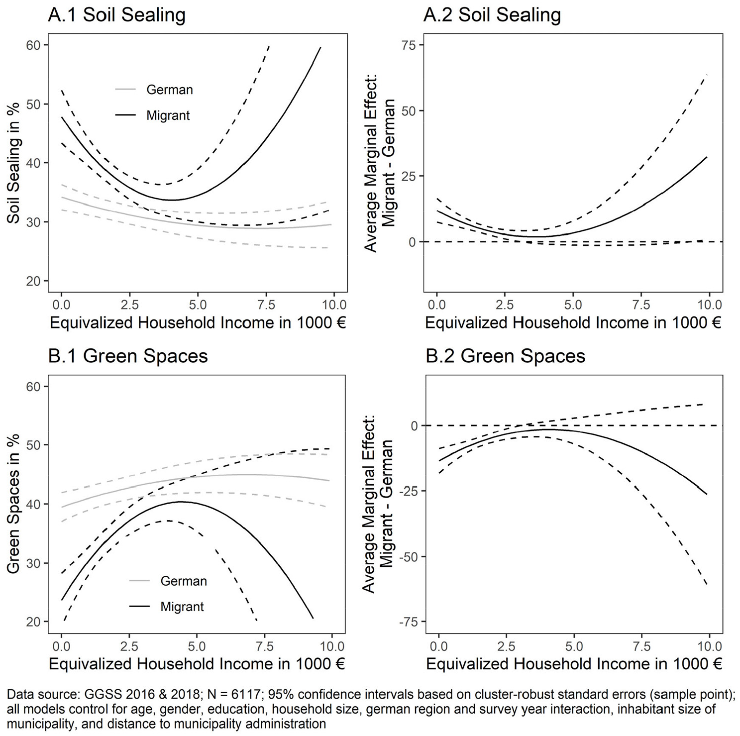
Predicted values for soil sealing, green spaces and the average marginal effect for migration background as functions of income.
Generally, for both groups, we find a decreasing slope for income. People with higher incomes live in neighbourhoods less exposed to soil sealing. While this slope is moderate for Germans, for migrants the slope is rather steep. Although soil sealing affects Germans less than migrants – even Germans with no income by <10 pp – higher income has a stronger effect for migrants.
Figure 2B comprises a similar plot for the individual predictions of green spaces and the corresponding AMEs. The results corroborate the soil sealing analysis, with the difference that the trajectories of the slopes are inversed. With higher income, green spaces in the neighbourhood are higher, although the increase rate seems to be slightly steeper for migrants.
Are these differential slopes statistically significant? Both figures show that the slopes tend to be the steepest until an income of approximately 4000 EUR. Therefore, it makes sense to calculate the AMEs of an income increase from, for example, 1000 to 4000 EUR, and to test them statistically as shown in Table 3. For Germans, a rise from 1000 to 4000 EUR reduces soil sealing exposure by 2.857 pp; for migrants, it does so by 8.007 pp. Green spaces are increased by 3.035 pp for Germans and by 9.893 pp for migrants. The second difference test evaluates the 5.150 pp difference between the groups concerning soil sealing and the −6.858 pp difference for green spaces: while for soil sealing, it is statistically significant at a level of p < 0.05, the p-value for green spaces is <0.001. The AME of migration background also corroborates these findings.
Average marginal effects and their tests of second differences for soil sealing and green spaces.
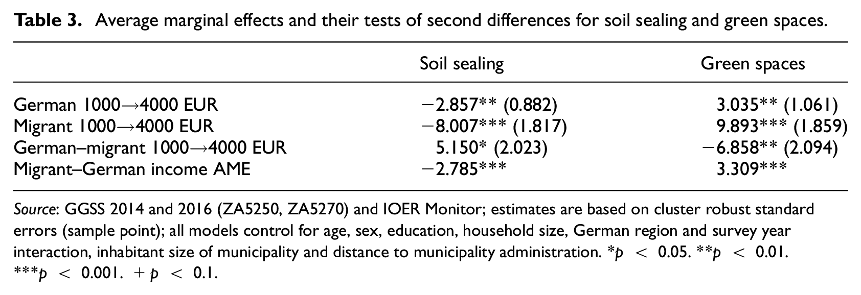
Source: GGSS 2014 and 2016 (ZA5250, ZA5270) and IOER Monitor; estimates are based on cluster robust standard errors (sample point); all models control for age, sex, education, household size, German region and survey year interaction, inhabitant size of municipality and distance to municipality administration. *p < 0.05. **p < 0.01.***p < 0.001. +p < 0.1.
Some of the migrants in our sample may mainly live in neighbourhoods with land use disadvantages since migrants on average happen to live in municipalities with higher population densities, yielding more land use. In Germany, population density on an aggregated level correlates with immigrant rates. 2 The models here control for population sizes at the municipality level but hold them constant at their individual values. There is a chance that urbanisation might cover patterns of residential segregation in the models. For example, the relationship between income and soil sealing exposure could differ between municipalities. Jarvis et al. (2020) also argued that urban green spaces might not directly correspond to nature exposure, typically found in more rural areas. In a final step, differences across urban and non-urban municipalities are examined.
Robustness check: The role of urbanity
Analysing urbanity in the relationship between income and land use disadvantages among the Germans and migrants leads to multivariate interaction effects. The predicted value of land use disadvantages changes depending on income, migration background and urbanity. To facilitate comparisons between these different trajectories, we again use AMEs.
Table 4 shows the results of AMEs across the variable of urbanity. The first column shows the estimates for soil sealing; the second column shows the estimates for green spaces. Moreover, the table comprises estimates of two models: one with and one without income interactions. The first row of the interaction model depicts the AME of income depending on migration background in non-urban municipalities, whereas the second row is the AME in urban municipalities. The third row provides the difference in these effects. Finally, the fourth row displays the AME of income depending on migration background without any urbanity interaction.
Average marginal effects and their tests of second differences for soil sealing and green spaces across non-urban and urban municipalities.
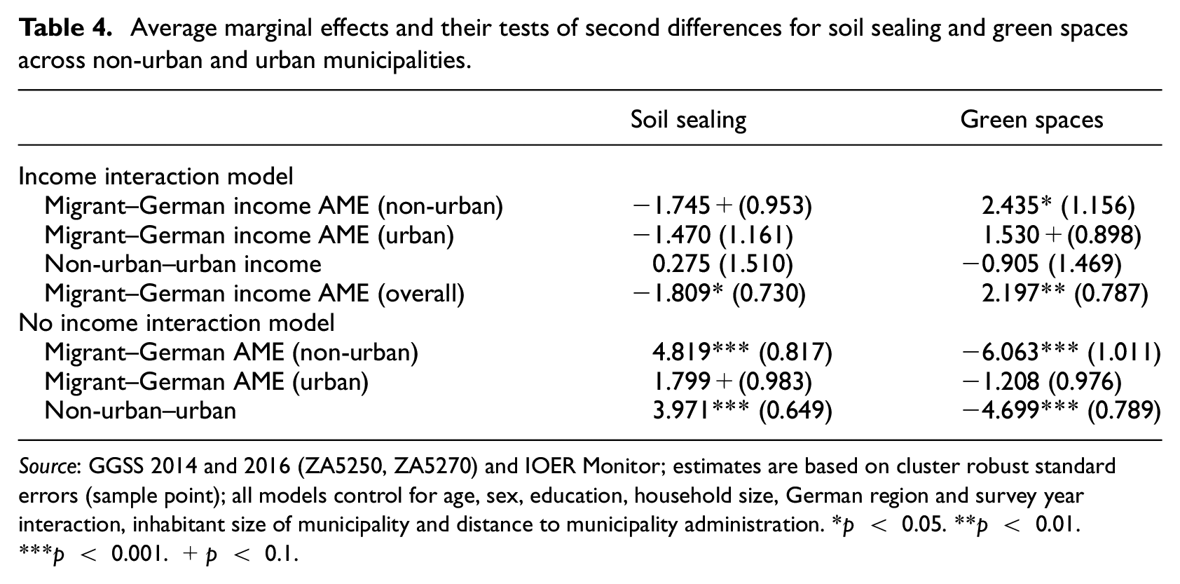
Source: GGSS 2014 and 2016 (ZA5250, ZA5270) and IOER Monitor; estimates are based on cluster robust standard errors (sample point); all models control for age, sex, education, household size, German region and survey year interaction, inhabitant size of municipality and distance to municipality administration. *p < 0.05. **p < 0.01.***p < 0.001. +p < 0.1.
It seems that there is no considerable difference across non-urban and urban municipalities. The AME for soil sealing provides weak results, and the AME for green spaces provides only minor statistically significant results. Moreover, there are no slope differences between urban and non-urban municipalities. However, estimating AME without the differentiation of urbanity reproduces the findings from the previous sections. The limitation is that the coefficients decrease slightly, and the level of statistical significance is reduced.
We further ask whether there is a general difference of environmental disadvantages exposure between non-urban and urban areas for people with a migration background. The estimates based on the models without income interactions provide information on this issue. In non-urban areas, compared to urban areas, people with a migration background are 3.971 pp more exposed to soil sealing on average than Germans. For green spaces, this difference is −4.699 pp. This finding does not mean that people with a migration background in non-urban areas are more exposed to environmental disadvantages than in urban areas (please refer to the Supplemental Material for figures on the overall exposure level). As such, similar to the findings of other studies (de Vries et al., 2020), the relative inequalities between Germans and people with a migration background in non-urban areas are more prominent.
Discussion
Concerning theory, the results of this study have multiple implications. In summary, they show that land use disadvantages decrease with higher income. This relationship can be found among Germans and migrants; however, low-income migrants mainly experience significantly higher disadvantages. While the slope between the two groups differs, it is steeper for migrants. Migrants require more income to reach similar levels of exposure as Germans.
The first finding of lower land use disadvantages with higher income corresponds to spatial assimilation theory. Soil sealing and green spaces are characteristic features of low- and high-quality neighbourhoods. We can assume that people choose neighbourhoods providing less soil sealing and more green spaces. Such places are mainly available if people’s income is at least at a certain level. This relationship explains the differences in land use disadvantages across the range of the income variable.
However, since land use disadvantages are higher for migrants in low-income groups, place stratification might also apply. It seems that inequalities are not solely due to socioeconomic and ethnic income inequalities but also due to disproportionate exposure between Germans and migrants in low-income groups. We do not know of actual discrimination from the GGSS; however, it is striking that these low-income differences are so pronounced. There is a systematic push of low-income migrants in low-quality neighbourhoods, which could be explained by discrimination in the housing market (Auspurg et al., 2017).
The robustness check testing for differences in this relationship between non-urban and urban municipalities is also revealing. Migrants tend to live in more urban areas in Germany; such land use disadvantages may be due to differential segregation patterns between Germans and migrants. However, the interaction between income and migration background is not moderated by urbanity. While land use disadvantages are higher in urban municipalities, the trajectories of income are not affected. We cannot conclude that differential exposures are due to a preference model of segregation. In both non-urban and urban areas, low-income migrants are affected by more land use disadvantages.
Another important finding is the steeper slope of income for migrants. The incremental gain in neighbourhood quality is higher for migrants than for Germans, resulting in larger AMEs. Since income is modelled as non-linear, this relationship vanishes in higher-income groups. Nevertheless, it remains a consistent finding in both indicators of land use disadvantages. This high AME could be another sign of discrimination in the housing market. Since the slope for Germans is less steep, it may show that there is not as much to gain in neighbourhood quality, which speaks to the weak version of place stratification theory. Accordingly, for low-income migrants located in low-quality neighbourhoods, any increase in income is helpful. As income increases, taste-based discrimination decreases because maintaining it, even for higher-income migrants, may increase the costs for potential discriminators such as landlords (Auspurg et al., 2017).
Finally, what might be a concern is that the GGSS was conducted only in German, and not all migrants in Germany can sufficiently speak the language to participate. The migrants in the sample are not representative of all migrants in Germany, which means that the findings cannot be inferred to the whole population. However, from the standpoint of place stratification theory and discrimination theory in general, we can assume that the non-German-speaking population might experience even more difficulties in finding housing in high-quality neighbourhoods. Taste-based discrimination, particularly in low-cost housing situations, again does produce high costs in the ‘loss function’ of performing discrimination (Becker, 1971). Therefore, the effect of environmental inequalities in this study may even be underestimated.
Conclusion
This study investigates whether land use disadvantages affect Germans and migrants from different income groups at different levels, a common suspicion in the vast body of the environmental justice research but one that lacks individual-level contributions for Germany. In both groups, higher income is associated with fewer land use disadvantages, indicating that income helps people to afford to live in better neighbourhoods. Migrants of low income typically experience more land use disadvantages and require more income to reach similar neighbourhood quality levels as Germans.
Neither the proposed spatial assimilation theory nor place stratification theory provides clear explanations for all the findings. Indeed, income eliminates some of the ethnic inequalities; however, this is only true for Germans and migrants with higher incomes. In the low-income group, inequalities persist, which speaks to ethnic discrimination and the weak version of place stratification. Although land use is a more indirect measure than those employed in other studies of environmental inequalities, such indicators also create evidence for distributional injustices in Germany.
Future investigations could again inspect the longitudinal dimension of ethnic segregation, socioeconomic resources and environmental disadvantages. While Best and Rüttenauer’s (2018) panel study of subjective pollution experiences weakened the role of income, the present cross-sectional study with objective indicators of environmental disadvantages strengthens it – at least for minorities and low-income groups. Migrants are worse off across the entire income range; low-income groups in particular experience higher levels of, for example, soil sealing. Nevertheless, the income effect for migrants generally remains small to moderate. However, as the analysed environmental disadvantages are only two of the many stressors impacting people’s lives, including discrimination experiences, the findings still can be considered to be substantially significant. Thus, adding survey respondents’ information about experienced discrimination to the table could disentangle these conflicting findings.
Moreover, urbanity cannot explain the effect between income and migration backgrounds. Some people remain exposed to land use disadvantages regardless of the urbanity, although other urban forms, such as the centrality of industry sites and their effects on ethnic segregation (Rüttenauer, 2019), may be of interest for future work. Given the continually growing land use in Germany, these environmental inequalities could increase in the next few years. When cities aim to enhance the number of recreational areas to compensate for the deleterious effects of land use (Kabisch and Haase, 2014), they should also consider the inequality dimension of such efforts (Wolch et al., 2014). Therefore, it is also of great interest to policymakers to determine which mechanisms are in place when people seek to use income as a vehicle to move to a new neighbourhood.
Supplemental Material
sj-zip-1-usj-10.1177_00420980211023206 – Supplemental material for Land use disadvantages in Germany: A matter of ethnic income inequalities?
Supplemental material, sj-zip-1-usj-10.1177_00420980211023206 for Land use disadvantages in Germany: A matter of ethnic income inequalities? by Stefan Jünger in Urban Studies
Footnotes
Acknowledgements
I would like to thank the three anonymous referees for their comments, which vastly improved the article. I am also grateful for the input of the Urban Studies editors and Pascal Siegers for reviewing the original manuscript. Karsten Hank, Alexia Katsanidou and Daniela Jünger provided valuable remarks. Furthermore, I received useful comments from participants at the GESIS Panel User Conference and the ESA RN21 mid-term conference.
Declaration of conflicting interests
The author declared no potential conflicts of interest with respect to the research, authorship, and/or publication of this article.
Funding
I gratefully acknowledge financial support from the German Research Foundation.
Supplemental material
Supplemental material for this article is available online.
Notes
References
Supplementary Material
Please find the following supplemental material available below.
For Open Access articles published under a Creative Commons License, all supplemental material carries the same license as the article it is associated with.
For non-Open Access articles published, all supplemental material carries a non-exclusive license, and permission requests for re-use of supplemental material or any part of supplemental material shall be sent directly to the copyright owner as specified in the copyright notice associated with the article.