
Abstract
The thick glutenite formed in the Linhe Depression of the Hetao Basin during the Early Cretaceous offers notable exploration potential. However, the sediment comprises a rapidly stacked succession of glutenite featuring poor sortability, with the individual sedimentary layers reaching up to 120 m in thickness. However, the limited core variations coupled with the “dentate box” shape of the well logging curves pose challenges in identifying the sedimentary microfacies of the study area, thereby hindering its exploration and development. This study selected the Jihua-2 block in the Linhe Depression as the study area and attempted to identify the sedimentary microfacies in the thick glutenite formed in this region. Results indicate that under arid and shallow-water conditions, the Langshan Fault continued to move, and a set of thick-bedded glutenite masses was deposited in the downthrown block. Detailed core observations revealed seven lithofacies and five lithofacies combinations. The study area is mainly characterized by a fan-delta front, which is further subdivided into the main part of underwater distributary channels, lateral margins of underwater distributary channels, and interdistributary bays. By integrating probabilistic distribution statistics with single well analysis, a quantitative standard for identifying well logging facies based on cored wells was established. Kriging interpolation was performed to clarify the spatial distribution of the sedimentary microfacies across the study area, enabling the establishment of a depositional model of fan-delta facies for the study area. The influence of faults on sedimentary facies and the relation between depositional patterns and hydrocarbon distribution in the study area were also discussed. The findings of this study can contribute to the development of improved methods for identifying sedimentary microfacies in glutenite fan deltas, with implications for guiding exploration and development.
Introduction
Fan deltas are coarse-grained depositional systems formed where alluvial fans prograde directly into a lake or ocean. 1 It is generally believed that alluvial fans serve as a source of sediment on land, and in steep slopes or areas with steep structural slopes, they form sedimentary structures with coarser sediment particles as transition zones. These depositional systems provide a record of tectonic, climatic, and datum changes in the piedmont.2,3 Furthermore, the fan deltas in oil and gas basins serve as good oil and gas reservoirs. 4
Previous studies have classified fan deltas into three main types based on their stratigraphic architecture and cyclic patterns: progradational, retrogradational, and aggradational. Progradational fan deltas, 5 with sedimentary characteristics similar to those of alluvial fans, are typically subdivided into fan root, middle, and edge. Nemec et al. further classified retrogradational fan deltas into fan-delta plain, fan-delta front, and pro-fan-delta. 1 The fan-delta plain is characterized by gravelly braided channels with crossbedding. 6 The fan-delta front typically comprises well-sorted and rounded conglomerates with abundant bedding structures, which are further divided into underwater distributary channels, interdistributary bays, and distal sand bar microfacies, whereas pro-fan-delta sediments are dominated by fine-grained siltstone and mudstone.7,8 In addition, aggradational fan deltas are characterized by the development of basal layers, top layers, and pre-accrets. The prelayers, often located at the margins of tectonically active basins with steep slopes, are dominated by heterolithic conglomerates, conglomerate sandstones, and sandstones. 9
The identification of sedimentary facies relies on various methods, among which core observation is the most direct method. Well logging offers valuable information regarding reservoir properties, including the mineral composition and structure of the rocks, and can help determine the rock types present in the reservoir.10,11 However, the manual interpretation of these data can run the risk of being subjective, thereby introducing inconsistencies in the identification of sedimentary facies.12,13 To address this issue, lithofacies are analyzed via multivariate statistical methods, including cluster analysis,14,15 and regression analysis, often in conjunction with physical models.
Recent research has focused on the sedimentary facies of the Linhe and Jilantai Depressions. Studies by Zhang Ruifeng, Wang Huilai, Li Chenxi, and others have identified fan-delta and lacustrine facies in the Linhe Depression,16–20 whereas Sun Liuyi, Lu Lu, and others have classified the Guyang Formation in the Jilantai Depression as comprising lacustrine, dryland-fan, and fan-delta facies.21,22
However, detailed studies of the sedimentary facies of the Jihua-2 block remain limited. Only a few studies have provided detailed descriptions of the sedimentary microfacies this area, making it difficult to develop a unified framework for sedimentary misfacies classification. The Jihua-2 block of Jilantai Oilfield in the Linhe Depression was selected as the study area to address this gap and probability distribution statistics of well logging data and kriging interpolation were used to characterize the spatial distribution of the sedimentary facies of this area. The findings of this study can refine our understanding of the depositional system in this area and aid future exploration and development efforts.
Geological setting
The Hetao Basin is a Mesozoic–Cenozoic continental basin formed by superimposed depression and faulting. 23 Covering an area of approximately 4 × 10⁴ km2, it exhibits a “dustpan” shape, deepening toward the northwest. 24 Its evolution began during a tectonic transition from compression to extension in the North China Plate. It comprises five first-order tectonic units that are relatively symmetrically distributed (Figure 1(a)). The basin fill predominantly comprises Cretaceous, Paleogene, Neogene, and Quaternary sedimentary rocks.
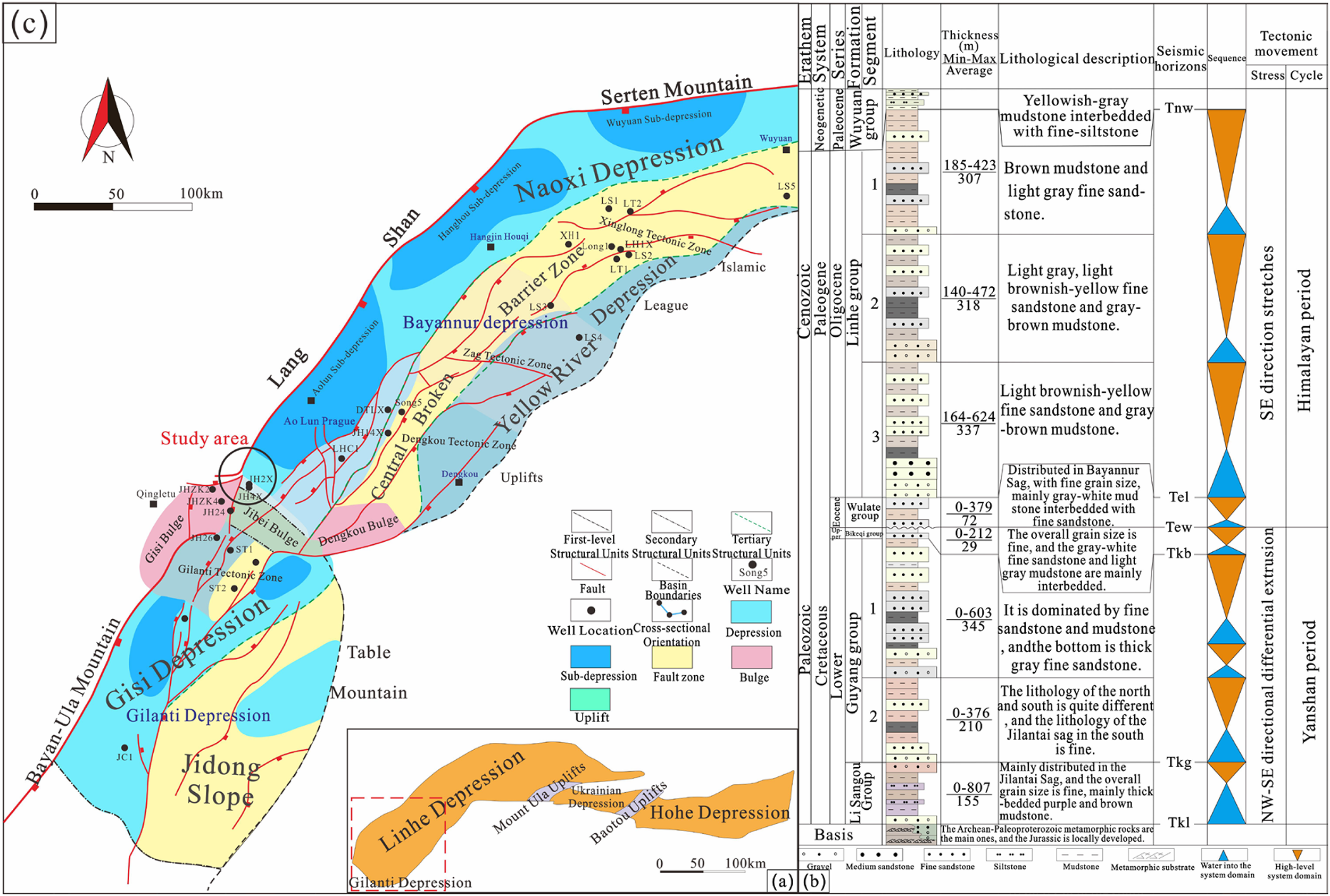
Location of the study area (a. Map of Hetao Basin; b. Comprehensive stratigraphic histogram of the Linhe Depression in the Hetao Basin; c. Structural map of Jihua-2 block in the Jilantai oilfield).
The Linhe Depression, a semigraben within the southwestern Hetao Basin, is characterized by a northeast–southwest trending axis and a northward deepening geometry.19,20 This region is the primary hydrocarbon-producing area within the basin (Figure 1(b)). The Guyang Formation represents the Lower Cretaceous strata within the Linhe Depression; this formation unconformably overlies the Archean crystalline basement and is directly overlain by the Paleogene Linhe Formation. The area selected in this study encompassed the southwestern portion of the Linhe Depression, specifically the Jihua-2 block. This area is characterized by a fault-nose structure controlled by the Langshan Fault, with strata dipping to the southeast (Figure 1(c)). 25 The predominantly Cretaceous Guyang Formation was deposited under arid climatic conditions.26,27 This formation is subdivided into two members, namely, K1g1 and K1g2. The current study focused on the lower member (K1g1), which is further divided into two oil groups (K1g1-I and K1g1-II).
The Sr/Ba ratio progressively increases in sedimentary rocks with increasing distance from terrestrial marine sediment sources. 28 Shallow-water environments typically exhibit Sr/Ba ratios of <1, whereas deep-marine sediments exhibit ratios >1.29,30 Trace element analysis of fine-grained mudstone samples from the study area, with minimal clastic contamination, revealed consistent Sr/Ba ratios of <1 (Figure S1), indicating deposition in a shallow-water environment.
Materials and methods
This study constructed a comprehensive dataset comprising cores, petrographic thin sections, well logs, and seismic profiles. Stratigraphic thickness was obtained through seismic data interpretation, whereas paleogeomorphology was reconstructed by integrating regional tectonic evolution. Higher sand-to-mud ratios and sandstone/conglomerate proportions indicate proximity to the sediment source and reflect rapid sediment accumulation. These parameters were combined with seismic data to determine the provenance and depositional facies.
Sedimentary microfacies were identified based on characteristic features, including lithological associations, grain size, sedimentary structures, and lithofacies types. Seven cored wells were individually analyzed to identify the sedimentary microfacies types. These core-based interpretations were then compared with well logging data to define facies characteristics, providing additional criteria for microfacies identification in uncored wells.
Kriging, a widely used geostatistical interpolation method, was employed to analyze spatial variability, interpolate between point observations, and generate facies maps with associated uncertainties. Based on single-well sedimentary microfacies templates, natural potential (SP), natural gamma (GR), and sonic time difference (AC) logs, which exhibited the strongest correlation with facies, were selected for the analysis. A combination of statistical methods (normal distribution analysis) and kriging interpolation was used to predict the spatial distribution of sedimentary microfacies across the study area.
This integrated approach enabled a detailed characterization of the lithofacies, sedimentary structures, and well logging facies markers within the K1g1 interval of the Jihua-2 block. This analysis robustly identified the sedimentary microfacies of the study area and established the development of a comprehensive glutenite fan-delta depositional model.
Results
Provenance analysis
Sandstone to stratigraphic thickness ratio and distribution of glutenite deposition
The Jihua-2 block, located in the southwest region of the Linhe Depression, is characterized by a relatively high sandstone to stratigraphic thickness ratio, indicating a relatively well-developed glutenite deposition and abundant sandstone and conglomerates within the stratigraphic succession. This ratio is the highest in the western region of the depression and gradually decreases toward the center of the area, suggesting a western provenance (Figure S2(a)).
The percentage of glutenite is the highest near the Langshan Fault and gradually decreases toward the center of the basin. This further supports the interpretation of a western source, specifically from the Langshan uplift (Figure S2(b)).
Paleogeomorphological features
This study employed the method of leveling layers to restore the original paleotopography of the study area and analyzed the provenance of the sediments. 31 In underwater depositional environments, flow velocity and direction are influenced by topographic variations.32,33 Paleogeomorphic analysis revealed a tectonic uplift in the study area during the deposition of the K1g1 interval, with a structural high located in the west. This corroborates the interpretation of a western provenance of the sediments, likely derived from the Langshan uplift (Figure S3).
Sedimentary facies markers
Petrological characteristics
The statistical analysis of the glutenite samples obtained from the study area revealed moderate-to-poor rock sorting (Table 1), with gravel clasts reaching sizes of >5 cm. Microscopic observations of the worn glutenite surface were characterized by incomplete edges and circles. Overall, the combination of low textural maturity, poor sorting, and abundant muddy impurities indicated a close-by source and turbulent water environment (Figure S4).
Sorting coefficients of the conglomerates in the first member of the Cretaceous Guyang Formation (K1g1).

Sedimentary tectonic characteristics
Through the observation and description of the coring wells, the bedding structures in the study area primarily comprised parallel, blocky, and grain sequence beddings, whereas the layering structures primarily comprised scouring surfaces.
(1) Parallel bedding: Characterized by parallel layer lines, this bedding type is formed by the deposition of sand and gravel transported via rolling and saltation under high-energy conditions. It is primarily observed in sandstone within underwater distributary channels (Figure S5(a)). (2) Massive bedding: This bedding type indicates the rapid vertical accretion of sediment with no discernible internal structure and is common in proximal depositional settings such as alluvial fans and fan deltas. It is characterized by a wide range of clast sizes (Figure S5(b)). (3) Grain sequence bedding: This is defined by a gradual change in grain size within a bed, with planes that are essentially parallel to each other (Figure S5(c)). In the study area, normal grading (fining upward) is observed, consistent with deposition within river channels. (4) Wavy bedding: This bedding is typically formed under the hydrodynamic action of waves or currents, where sediment particles are arranged in a regular wave-like structure. It is often found in environments with low water energy (Figure S5(d)). (5) Deformed bedding: This bedding is characterized by a layer of thin mudstone that protrudes upward under the gravitational compression of the overlying thick sandstone (Figure S5(e)). (6) Erosion surface structure (Figure S5(f)): This represents relatively flat sedimentary surfaces that truncate underlying strata, often exhibiting scour marks and evidence of sediment reworking. These surfaces indicate fluctuations in flow energy and are commonly associated with shallow lake depositional environments.
Lithofacies characteristics
Detailed sedimentological analysis of 317.78 m of core from seven wells in the Jihua-2 block enabled the identification of seven distinct lithofacies, which were divided according to lithology, particle size, support type, and sedimentary structure (Table 2). These included heterogeneous support conglomerate facies (Gg), sandy support conglomerate facies (Gs), multilevel grained support glutenite facies (Gp), argillaceous support glutenite facies (Gm), conglomerate-bearing argillaceous sandstone facies (Sm), medium-coarse sandstone facies (St), and silt-fine sandstone facies (Sp) (Figure 2). The JH2-312x well (Figure S6), which contains the most comprehensive core data, served as the primary basis for detailed petrofacies analysis.

Main lithofacies in the study area.
Classification of lithofacies types in the study area.

Integrating the tectonic setting with the observed lithofacies characteristics indicates that the study area represents a fan-delta front depositional environment. Based on distinctive lithofacies assemblages, this environment can be further subdivided into three subenvironments: the main part of the underwater distributary channels, lateral margins of the underwater distributary channels, and the interdistributary bays.
Interdistributary bays (Sm-Sp): This subenvironment is characterized by a low-energy setting with weak hydrodynamics, typically situated between adjacent distributary channels. The most characteristic feature is a vertical succession from conglomerate-bearing argillaceous sandstone facies in the lower part to silt-fine sandstone facies in the upper part (Figure 3(a)). Lateral margins of the underwater distributary channels (Gg-Gp-Gm or Gp-Gm-St): This subenvironment represents areas where the energy and carrying capacity of the distributary channels decrease laterally. Two distinct lithofacies assemblages were observed, heterogeneous support conglomerate facies (Gg) transitioning upward to multilevel grained support glutenite facies (Gp) and then to argillaceous support glutenite facies (Gm) or multilevel grained support glutenite facies (Gp)-transitioning upward to argillaceous support glutenite facies (Gm) and then to medium-coarse sandstone facies (St). These assemblages indicate depositions dominated by traction flow sedimentation, with the potential for weak scouring surfaces at the base (Figure 3(b)). Main part of the underwater distributary channel (Gs-Gp-Gm or Gg-Gs-Gp): This subenvironment represents the main conduits for sediment transport and has the widest spatial distribution. Traction currents were dominant, resulting in two typical lithofacies assemblages, namely, sandy support conglomerate facies (Gs) transitioning upward to multilevel grained support glutenite facies (Gp) and then to argillaceous support glutenite facies (Gm) or heterogeneous support conglomerate facies (Gg) transitioning upward to sandy support conglomerate facies (Gs) and then to multilevel grained support glutenite facies (Gp). These assemblages suggest that sand-rich sediment gravity flows may contribute to deposition at the base of proximal channels, whereas the middle and upper parts are dominated by traction currents, resulting in an overall coarse and fine grain size (Figure 3(c)).

Lithofacies associations in the fan-delta front of the study area.
Probabilistic distribution statistics and kriging interpolation
The K1g1 member in the study area is characterized by a thick succession of glutenite depositions, showing generally box-shaped well logging curves. This lithological homogeneity makes it difficult to identify detailed sedimentary microfacies based solely on the log curve shapes. To overcome this challenge, we employed quantitative analysis and the probabilistic distribution statistics of well logging data with kriging interpolation to identify the sedimentary microfacies.
These interpretations were then applied to noncored wells to identify representative wells for each facies. Next, the distribution intervals of the AC, SP, and GR logs for each microfacies were statistically analyzed using a normal distribution model to establish initial quantitative criteria for facies identification. Finally, these criteria were used as input for kriging interpolation to predict the spatial distribution of sedimentary microfacies across the entire study area.
Technical process introduction: This method involved conducting a single-well facies analysis using core data to define the sedimentary structures, lithofacies, and corresponding well logging responses for each microfacies. These interpolations were then applied to noncored wells to identify the representative wells for facies identification. Next, the distribution intervals of the SP, GR, and AC logs for each microfacies were sorted, and the corresponding logging curve intervals were calculated. The standard intervals were calculated and then tested for accuracy. After comprehensively analyzing the logging curve parameters, the initial quantitative criteria for facies identification were identified. Finally, these criteria were used as input for the kriging interpolation method to predict and image the spatial distribution of sedimentary microfacies across the entire study area (Figure S7).
Initially, three cored wells (JH2-312x, JH2-234x, and JH2-327x) were selected to develop the sedimentary facies identification standards. However, relying only on these wells limited the applicability and accuracy of the resulting criteria. To enhance the robustness of the analysis, five noncored wells (JH2-204x, JH2-211x, JH2-221x, JH2-224x, and JH2-341x) were added to the dataset. Analyzing the K1g1-Ⅱ interval across these eight wells provided a broader range of log responses for each facies.
Subsequently, to mitigate the influence of the wide range of SP values, this log curve was preferentially normalized. The log curve data from the eight wells were used to define the initial intervals for each facies, with values covering 80% of the total range, including the average value, being selected as the initial microfacies standard. For example, the initial standard intervals for the main part of the underwater distributary channels were 43.879–64.269 for GR, 0.045–0.52 for SP, and 227.784–275.384 for AC. Additionally, the standard intervals for the SP, GR, and AC logs of the lateral margins of the underwater distributary channels were 48.49–68.40, 0.0571–0.6684, and 229.913–266.813, respectively, and those for their interdistributary bay channels were 50.97–70.9, 0.6447–0.94, and 223.44–251.38, respectively.
A Petrel geological model was constructed using the available well logging and lithological data. The initial facies intervals were input, and the dataset was used to train and validate the model. The results were compared with those for the single-well facies interpretations, and the quantitative identification intervals were iteratively refined. The performance was considered acceptable when the predicted facies matched the observed facies for a single log curve at least 70% of the time. The three logs were then integrated into a single curve for facies identification, considering the cored well JH2-312x as an example (Figure S8).
Analysis of the match between the individual logs, integrated log curve, and the actual sedimentary facies across the eight wells showed that the SP curve had the highest accuracy (81%), followed by the AC and GR curves (80%). The overall accuracy of the integrated facies prediction reached 80.12%. These results informed the adjustment of the initial intervals to establish the final quantitative identification standard (Table 3).
Quantitative identification standards for microfacies using the well logging curves of different sediments.

The identification criteria were used to calculate the probability of microfacies occurrence in uncored wells, and kriging interpolation was performed using Petrel software. This process predicted the spatial distribution of sedimentary facies in areas without well control, ultimately generating a map of the spatial distribution of sedimentary microfacies across the study area (Figure S9).
Types of sedimentary facies
Through the analysis of petrology, sedimentary structure and lithofacies characteristics, the study area is characterized by a continental fault-controlled fan-delta depositional system. Three primary microfacies were identified within the fan-delta front, namely, the main part of the underwater distributary channels, the lateral margins of the underwater distributary channels, and the interdistributary bays.
The main part of the underwater distributary channel is relatively well-developed in the study area and characterized by glutenite deposition with block-like bedding. Additionally, fining-upward successions are common. The GR logs exhibit a smooth box shape, with values ranging from 43.879 to 62.7010 API, and the normalized SP values range from 0.038 to 0.494. This microfacies exhibited the highest oil content, and two lithofacies associations were observed: Gs-Gp-Gm or Gg-Gs-Gp.
Lateral margins of the underwater distributary channels: The microfacies in this region exhibits thinner glutenite beds compared with those in the main channel, with an increase in argillaceous content. The lithology is primarily argillaceous or sandy conglomerate with higher argillaceous content. The SP and GR logs were either low-amplitude bell shaped or high-amplitude finger shaped. The GR values ranged from 53.77 to 68.71 API, and the normalized SP values ranged from 0.047 to 0.575. This microfacies exhibited good oil content, and two lithofacies associations were observed: Gg-Gp-Gm or Gp-Gm-St.
The physical properties of the interdistributary bays are poor, and the microfacies in this region is dominated by argillaceous sandstone. The GR logs exhibited a serrated, finger-like shape, with values ranging from 58.44 to 76.18 API. Additionally, the normalized SP values ranged from 0.66 to 0.97, and the AC logs ranged from 223.44 to 251.38. This microfacies had a single lithofacies association: Sm-Sp.
Spatial characteristics of sedimentary facies
During the deposition of the K1g1-II oil group, tectonic activity in the Jilantai tectonic belt was weak, and the lake level continued to fall. The glutenite succession in the study area is the thickest in the west and thins eastward. The overall depositional pattern reflects a regressive sequence, with sand bodies prograding from the Langshan uplift toward the basin center. Two main distributary channels were identified. One extending northwestward from the core well JH2-204x to JH2-318x, characterized by a finger-like geometry, and the other extending from the core well JH2-204x to JH2-318x in the northwest. This also extends from the core well JH2-244x in the southwest to JH2-357x. The lateral margins of the underwater distributary channels are developed along the periphery of these channels, where the hydrodynamic force is weak. Interdistributary bays were identified in the area between the core wells JH2-4x and JH2-222x. A thick sand body (JH6x) in the east exhibited characteristics of an underwater distributary channel, indicating that fan-delta deposition extended further eastward beyond the main study area (Figure 4).
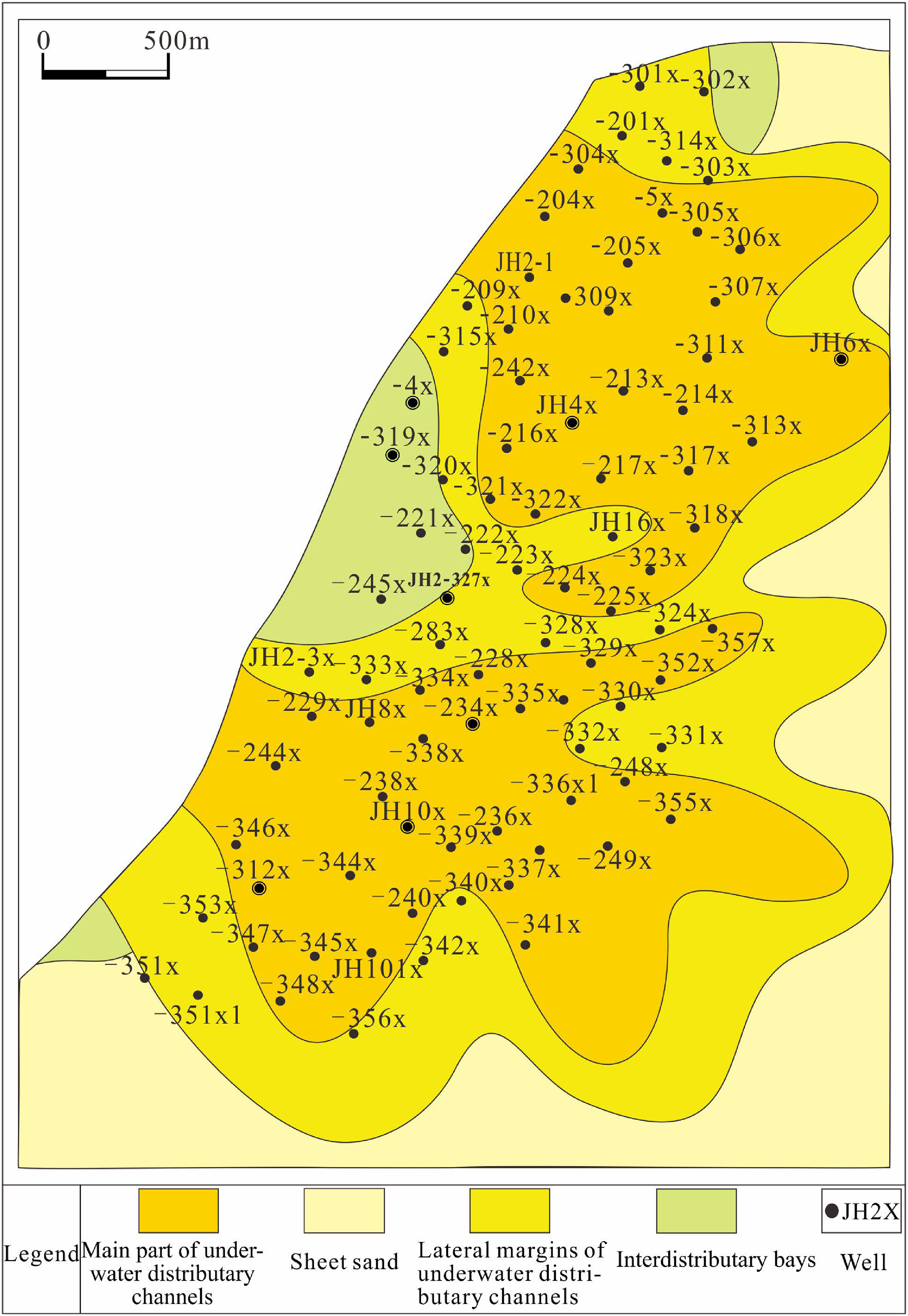
Spatial distribution of sedimentary microfacies in the K1g1-II oil group.
Discussion
Depositional model
The K1g1 member of the Jihua-2 block in the Linhe Depression was deposited in a shallow-water environment. Based on the analysis of drilling, core, and regional data, we interpreted that the study area represents a fan-delta front. This system was formed by the rapid accumulation of coarse-grained detritus sourced from the Langshan uplift within a short period under multiple strong hydrodynamic conditions transported by high-energy braided fluvial systems. These sediments prograded basinward, depositing in a shallow lake and forming a ring-shaped distribution around the fan-delta front.
Upon entering the lake, the fluvial sediments were reworked and redistributed via subaqueous processes, forming the main part and lateral margins of the underwater distributary channels (shallow detritus around the channel that formed the microfacies). The interdistributary bays were characterized by finer-grained sediments and thinner successions and developed between the channels. The main part of the underwater distributary channel exhibited the greatest thickness, best sorting, and a high degree of rounding, making it the most favorable zone for hydrocarbon exploration. Additionally, it was the most active part of the fan delta, with the channels undergoing hydrodynamic changes in scale over time. Multiple short-term flood events resulted in the deposition of thick glutenite bodies, reaching a maximum thickness of >250 m (Figure 5).

Diagram of the depositional model in the study area.
Controlling factors of sedimentary facies
The Langshan Fault is a long-lived syn-depositional fault that influenced the distribution of sedimentary facies in the study area. The upthrown block, located west of the study area, is characterized by fan-delta plain deposits. The study area, situated on the downthrown block, is dominated by arid, shallow-water fan-delta front facies, which can be further subdivided into the main part of the underwater distributary channels, lateral margins of the underwater distributary channels, and the interdistributary bays. Variations in fault displacement along the Langshan Fault resulted in the development of two river channel valleys that focused sediment delivery to the study area, forming two main channels that served as sediment supply pathways for the study area. The paleogeomorphic map revealed a structural high center at the core well JH2-284x in the middle of the study area, flanked by low-lying terrain. These flanking depressions acted as conduits for sediment transport into the basin. The statistical analysis of sand body thickness shows that the sand bodies thin over the uplift, resulting in an overall pattern of thicker deposits flanking the uplift. Both the paleogeomorphology and sand thickness distribution confirmed the presence of the two main distributary channels, further highlighting the influence of syn-depositional faulting on facies distribution.
The study area is dominated by a thick, rapidly deposited succession of glutenite with limited lithological variation. However, distinct differences are observed at the lithofacies scale. Among them, the main part of the underwater distributary channels is dominated by sandy support conglomerate facies (Gs), which exhibits good sorting, rounding, and reservoir quality. The lateral margins of the underwater distributary channels are dominated by argillaceous support glutenite facies (Gm), with higher mud content and poorer reservoir quality. Interdistributary bays are dominated by gravel-bearing argillaceous sandstone facies (Sm) with the lowest reservoir quality. The main part and lateral margins of the underwater distributary channels form stacked, multilayered sand bodies with interbedded muddy or fine-grained intervals. These intercalations result from fluctuations in flow energy and channel avulsion. These muddy interbeds are laterally discontinuous and can act as barriers to hydrocarbon migration, thus compartmentalizing the reservoir.
Conclusion
The area investigated in this study is characterized by thick glutenite deposition with limited lithological variation, making it challenging to differentiate sedimentary microfacies using well logging alone. Therefore, this study integrated facies analysis with statistical methods and kriging interpolation to quantitatively identify sedimentary microfacies in the study area. This approach enabled a detailed characterization of the sedimentary microfacies and the development of a comprehensive depositional model for the thick glutenite fan delta. The main conclusions can be summarized as follows:
Provenance analysis, based on the proportion of glutenite deposition and paleogeomorphological characteristics, indicated that the sediments were primarily derived from the Langshan uplift. The presence of coarse gravel (grain size > 5 cm) with irregular shapes suggests proximal deposition and a high-energy turbulent environment. Seven lithofacies were identified based on clast support and other sedimentary characteristics: heterogeneous support conglomerate facies (Gg), sandy support conglomerate facies (Gs), multilevel grained support glutenite facies (Gp), argillaceous support glutenite facies (Gm), conglomerate-bearing argillaceous sandstone facies (Sm), medium-coarse sandstone facies (St), and silt-fine sandstone facies (Sp). Conglomerates and glutenite facies were dominant. Additionally, five lithofacies associations were identified. The study area was interpreted as a fan-delta front depositional environment, comprising three subenvironments: the main part of the underwater distributary channels, lateral margins of the underwater distributary channels, and the interdistributary bays. Statistical analysis was used to define the well logging curve intervals characteristic of each microfacies. The identification results showed a strong correlation with core-based facies interpretations. The depositional model for the Jihua-2 block in the Linhe Depression highlights the controlling influence of the Langshan Fault on facies distribution. The study area, located on the downthrown block of the fault, is characterized by an arid, shallow-water environment dominated by fan-delta front facies. Two main distributary channels had developed in the areas of greater fault displacement. Sediment gravity flows transported debris into the shallow lake, forming the main part and lateral margins of the underwater distributary channels, with the interdistributary bays deposited between the channels. The main part of the underwater distributary channels exhibits the most favorable reservoir characteristics, representing the most promising target for hydrocarbon exploration.
Supplemental Material
sj-docx-1-sci-10.1177_00368504251326867 - Supplemental material for Depositional model of the fan delta of thick glutenite: Example from the Linhe Depression, Hetao Basin, China
Supplemental material, sj-docx-1-sci-10.1177_00368504251326867 for Depositional model of the fan delta of thick glutenite: Example from the Linhe Depression, Hetao Basin, China by Xiaofan Hao, Xuesong Yang, Bin Cao, Huilai Wang, Chenlin Wu, Chenya Li, Lin Qu, Jiye Li, Yongli Pan and Xiao Hu in Science Progress
Footnotes
Acknowledgements
The authors would like to thank PetroChina Huabei Oilfield Bayan Exploration and Development Branch for providing the necessary data and allowing the publication of this study.
Author contributions
Xiaofan Hao: conceptualization, methodology, validation, formal analysis, investigation, writing—original draft. Xuesong Yang: software, investigation, supervision, project administration. Bin Cao: validation, data curation, visualization. Huilai Wang: conceptualization, methodology, formal analysis. Chenlin Wu: formal analysis, resources, supervision. Chenya Li: software, resources, validation, funding acquisition. Lin Qu: validation, formal analysis, resources, supervision, project administration. Jiye Li: validation, resources, visualization. Yongli Pan: validation, formal analysis, data curation. Xiao Hu: conceptualization, methodology, software, writing—original draft, writing—review & editing, project administration.
Declaration of conflicting interests
The authors declared no potential conflicts of interest with respect to the research, authorship, and/or publication of this article.
Funding
The authors received no financial support for the research, authorship, and/or publication of this article.
Supplemental material
Supplemental material for this article is available online.
References
Supplementary Material
Please find the following supplemental material available below.
For Open Access articles published under a Creative Commons License, all supplemental material carries the same license as the article it is associated with.
For non-Open Access articles published, all supplemental material carries a non-exclusive license, and permission requests for re-use of supplemental material or any part of supplemental material shall be sent directly to the copyright owner as specified in the copyright notice associated with the article.