
Abstract
The solar unmanned aerial vehicle (UAV) route planning needs to comprehensively consider the conversion efficiency of solar cells under the influence of solar ground reflection radiation and sky scattering radiation. On the one hand, it is necessary to consider the cost of radar threat, mileage energy consumption, mountain impact and other costs. On the other hand, it is also necessary to consider the influence of high threat, mountain shadow occlusion cost, and cloud shading cost on solar photovoltaic conversion efficiency. The above problem was solved through using the ant colony intelligent optimization algorithm. By constructing ant colony paths rationally, models of mountain impact cost, high threat, mountain shadow shelter cost, and cloud shading cost were established. The constraints such as the maximum action distance, solar irradiation angle and effective action distance of various costs were introduced into the cost model and exploration factor calculation, and the comprehensive optimization problem of solar UAV route was solved. Finally, the simulation results show that the algorithm path structure is reasonable; the target node can be found independently; the convergence speed can meet the requirements of route planning; the generated route cost is small; the algorithm is reasonable and effective.
Keywords
Introduction
Solar drone, as the name implies, is a drone that uses solar energy as the power source for flight and operation, which has the main characteristics of ultra-long endurance, long-term empty space, ultra-high flight, and extensive operation, and its value is comparable to “quasi-satellite,” and it has the advantages of flexible deployment and good economy. In recent years, for the purposes of major natural disaster warning, high-altitude sea area patrol and supervision, emergency rescue and disaster relief, counter-terrorism and stability maintenance, mobile communications and other purposes, countries are investing in, accelerating research and development, and actively deploying the development of solar drones, hoping to seize a new highland in the future drone industry.1–7 UAV route planning usually only considers the impact of the cost of conventional threats such as radar, missiles, and anti-aircraft artillery, and performs combined optimization. Due to the advantages of small energy consumption, long flight range and long air time, solar drones are stepping up research on this problem and have achieved great development. Therefore, route planning for solar-powered drones is very urgent. Solar UAVs not only need to consider the above threat costs, but also need to combine their own characteristics, comprehensively consider the conversion efficiency of solar cells under the influence of solar ground reflection radiation and sky scattered radiation and other factors, in addition to radar and terrain threats, solar angle, terrain shadow, cloud shading and other factors affecting solar radiation into the calculation model, and finally in order to facilitate analysis, the UAV wing solar cell installation surface is simplified to a horizontal plane, and the solar UAV flies near the earth's equatorial plane. The project team carried out the route planning research of ant colony algorithm for ordinary UAVs in the early stage, and the algorithm has good convergence effect and is relatively easy to project and implement. I am responsible for researching the application of intelligent optimization algorithms to solar route planning problems under specific constraints. To this end, I introduced the ant colony optimization algorithm into the engineering application of solar UAV route planning problem, on the one hand, by reasonably constructing the ant colony path, and establishing the mountain impact cost, high threat, mountain shadow shelter cost, cloud shelter cost model; On the other hand, the constraints such as the maximum action distance, solar irradiation angle and effective action distance of various costs are introduced into the cost model and exploration factor calculation. Finally, the solution of the comprehensive optimization problem of solar UAV route is realized, and the effect is very good.8–10
Problem description11–20
Spatial grid generation
3D divides the grid into X, Y, Z directions, where the grid sizes are represented as
Route synthesis optimization
In addition to the cost of radar threat, mileage energy consumption and mountain impact threat, altitude threat, mountain shadow cover cost and cloud cover cost should be considered. The goal of route planning is to minimize the cost of the whole, and according to radar, mountain terrain, cloud distribution and other model constraints, there are some constraints, such as the maximum operating distance, the solar projection angle, the distribution of clouds and the effective killing distance. Among them, the radar has the possibility to detect the position of the UAV, the mountain terrain has the possibility to cause the UAV to be hit, and the cloud cover, the terrain cover will affect the solar cell photoelectric conversion efficiency, it is also about the energy security of drones, so they can all be considered a threat. All of these threats must be taken into account in order to calculate course performance. The threat cost function can be expressed as the weighted sum of the threat cost of radar, altitude, terrain shadow, cloud cover, terrain, energy consumption, etc.9–15

Establishment of solar radiation-related cost model
Solar energy UAV energy system usually includes two parts: solar battery and storage battery. Therefore, the photovoltaic conversion efficiency of solar cells, shading and other factors will directly affect the energy storage of UAV, and then affect the flight range and even flight safety. The photoelectric conversion efficiency is determined by the cell type. Shadow shadowing, on the other hand, requires the drone to be in a cloud or mountain shadow. Solar radiation comes from direct and scattering, respectively. Scattering can be divided into scattering by ground reflection and sky scattering. Since solar panels are mounted on the upper surface of the wing and no solar cells are mounted on the lower surface, the effect of ground reflected radiation on energy can be ignored.6–11

Direct radiation calculations
Direct radiation


In addition,

By synthesizing the equations, we can calculate


Calculation of sky scattering radiation
The wing panels of a solar-powered unmanned aerial vehicle (UAV) receive two parts of scattered radiation, namely the refracted and reflected sky scattered radiation energy.
6
This part of the Energy II is simplified as follows:

Both of these components are affected by
When flying in the equatorial plane, only the solar hour angle and the influence of clouds and mountains should be considered. Therefore, the influence of cloud cover and mountain shadow on the solar radiation energy can be analyzed as part of the main cost. Here’s how.
The shadow is seen as part of the cost of the solar energy conversion that is affected by the Sun shading of the UAV into the shadow area of the mountain. In this paper, we consider the time of the Sun rising in the east at the equator, the Sun illumination and the angle of the ground are h. If the central coordinates of the mountains are (
The shadow of the terrain is calculated as follows:
when When If If
When


Establishment of alternative cost models
There are some constraints in the threat model, such as the maximum operating distance and the effective killing distance. In this paper, the constraints are introduced into the objective function by establishing a reasonable objective cost function, in this paper, the models of different threats are defined as follows: the detection degree of radar to UAV can be approximately expressed as:

Terrain threat refers to the threat of impact caused by mountain obstacles when the UAV is flying at low altitude. The cone approximation is shown in Figure 2(a). The terrain radius is

Schematic diagram of mountain terrain occlusion cost.
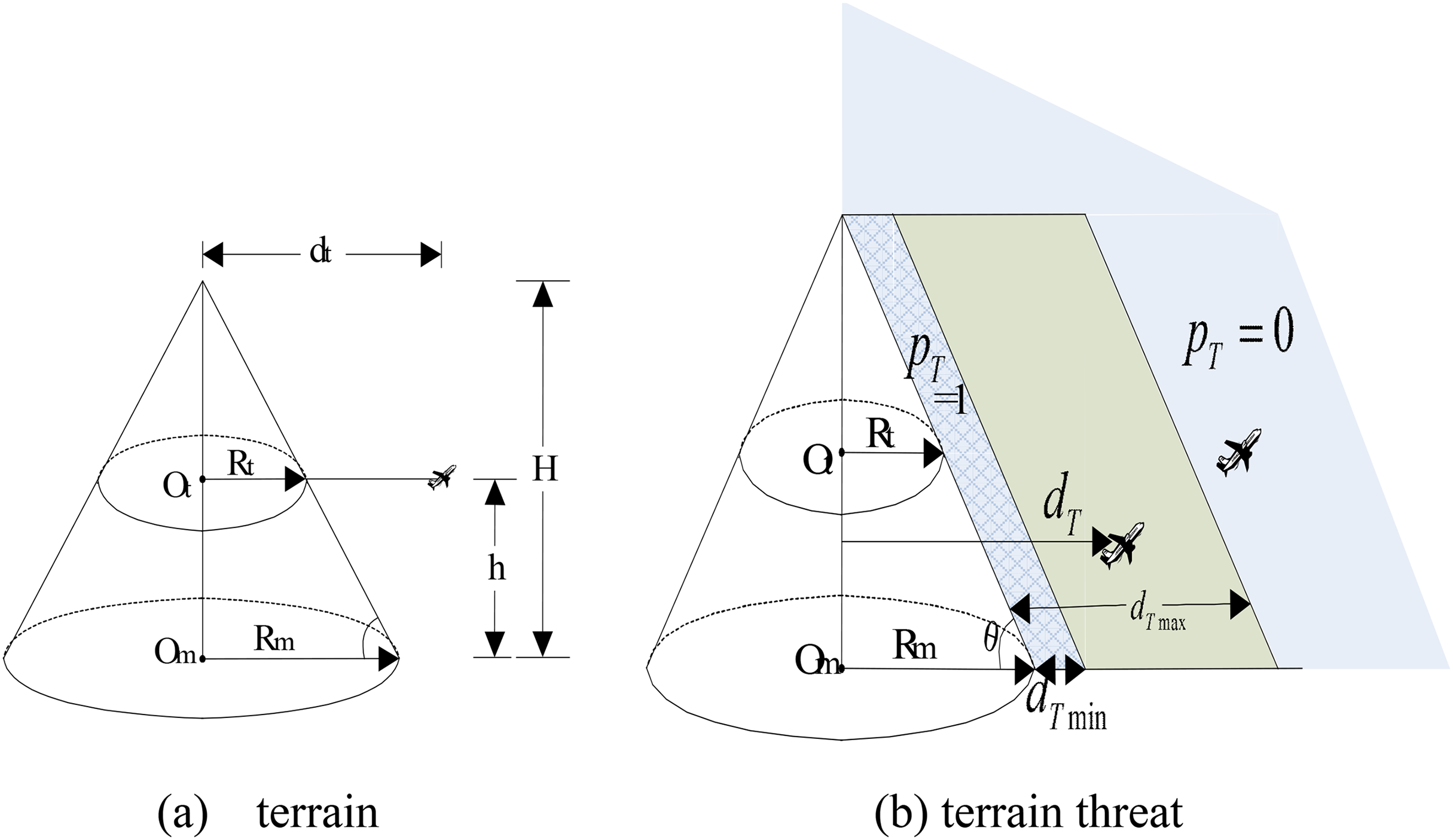
Schematic diagram of terrain threat cost.
The threat probability of terrain to UAVs varies with distance. The farther away from the mountains, the less likely the impact, and vice versa.


When the optimal objective function is determined, the weight of each edge in the network graph is also determined. That is, the cost weight of the first d edge in the network graph is calculated by the following cost function in the process of searching nodes5–10:

Therefore, the fundamental problem to be solved in solar route planning is to obtain a route with the lowest comprehensive cost, that is, the cumulative cost of each segment of the route is the smallest, that is, the solution is the least cost
Since the essence of this problem is to solve the combinatorial optimization problem with the best value under specific constraints, the algorithm can be constructed and solved by intelligent optimization algorithms. I carried out the research on the route planning of ant colony algorithm for ordinary UAVs in the early stage, and the algorithm has good convergence effect and is relatively easy to engineer. Therefore, the algorithm will continue to be used for the route planning problem of solar UAV, the cost model of the combinatorial optimization problem established in this section, and the specific construction and implementation of the ant colony-based algorithm will be detailed in the next section, including exploration factor design, state transition strategy, and pheromone update strategy.
Ant colony algorithm for route planning
Ant colony algorithm flow for route planning is shown in Figure 3.

Algorithm flowchart.
Exploratory factor design
The spatial coordinates representing the start and destination of the route, respectively. Represents the granularity of planning spatial meshing. Let


Exploratory factor design
The discovery factor was designed as a countdown to the threat cost. In the case of node j, the threat cost can be expressed as the sum of the costs of the six parts:

According to the formula above, the exploring factor of node j is calculated, which is the reciprocal of the threat cost of the node, so
State transition strategies
Let ant scale be

Pheromone update strategy
The parameter


Since the standard ACO cannot find the target node within the given number of ant colonies and the number of iterations when dealing with 3D route planning, it is necessary to improve the algorithm and introduce the target node factor to guide the ant colony to search for the target node.
TNF-ACO algorithm solves route planning problems
TNF-ACO algorithm refers to the construction of target node factors on the basis of the standard ACO algorithm, so that the algorithm.
Target node factor design
To solve the above two problems, this topic introduces the target node factor and sets the maximum number of track nodes. The conventional ant colony algorithm state transfer strategy is selected according to the probabilistic selection of pheromones and heuristic factors, without the target node factor, and the heuristic factor values of the 26 adjacent nodes in the state transfer strategy are not much different, so the local predictability of the target node is not strong, especially in the early stage of algorithm iteration, the pheromones between nodes are not much different, and the state transfer is easy to fall into blind selection, and it is difficult to quickly reach the target node. According to the needs of track planning problems, this paper introduces the target node as part of the state transition strategy, taking node i as an example, and the target node factor Q is expressed as:

In addition, the UAV has a maximum range parameter, that is, the flight range of the UAV throughout the flight, which is limited by the ration of aircraft fuel and flight time. If the maximum track length is

State transition policy improvements

Different from the standard ACO algorithm, this paper introduces the target node factor
The values of
Considering the constraints such as different threat ranges, this paper also considers the conditional constraints for the heuristic factor
Then
The ES-TNF-ACO algorithm solves the route planning problem
ES-TNF-ACO algorithm
The ES-TTF-ACO algorithm refers to an algorithm that introduces an elite strategy on the basis of the TNF-ACO algorithm and retains the excellent population of the previous generation as a route for the next generation. Specifically, the following three improvements have been made:
Retain the best routes of the previous generation as one of the contemporary routes and achieve an elite strategy. Achieve relatively fast convergence and reduce iteration of invalid paths. Discard pheromone enhancement on invalid routes where all ant colonies do not reach the target point. Among the 26 adjacent nodes of the current node, exclude nodes whose search direction does not deviate from the target node, so that the state transition probability of the current node transferring to this node is 0.
Specific implementation methods
(1) The path node of the first ant is fixed to the path node of the previous generation with the most ants, so as to retain the elite and realize the convergence and search optimization of the algorithm.
The specific implementation code is as follows:

where, CN represents the current number of iterations, Ant_x(1,:) represents the coordinate x of the first ant, Ant_y(1,:) represents the coordinate y of the first ant, Ant_z (1,:) represents the coordinate z of the first ant, Ant_lie (1,:) represents the column sequence number in the spatial grid of the first ant, Ant_ha(1,:) represents the row serial number of the first ant in the planning spatial grid, and Ant_gao(1,:) Indicates the high ordinal number of the first ant in the planning space grid, and the Ant_NetPoint (1,:) indicates the node ordinal number of the first ant in the planning space grid.
(2) Pheromone update strategy improvements
If there is an ant k route path length equal to the maximum path length
The specific implementation code is as follows:

Among them: Delta_Tau represents the pheromone increase matrix, gm represents the number of ants, and letht calculates the route length of the ith ant.
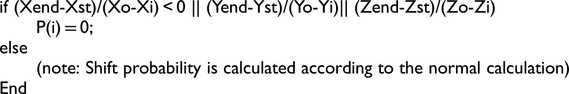
(3) Set the direction divergence node shift probability to 0
The specific implementation code is as follows:
Example simulation of route planning
In this paper, the route planning of solar energy UAV is simulated by intelligent optimization algorithm. Simulation set the specific radar, clouds, flight starting and ending coordinates, as shown in Table 1. The parameters of radar model and weight are set to
Coordinates of some threat points.

The terrain model is composed of six mountains with different centers and heights. The figure of the natural index of the mountains with e as the base is expressed as follows.

Where,
Figure 4(a) and (b) are 3D plots and contour plots of 3D track planning of standard ACO algorithm, respectively. Figure 5(a), (b) and (c), respectively, simulate the 3D trajectory planning 3D map, contour plot and convergence curve obtained by TNF-ACO algorithm under the condition of Q = 10. Figure 6(a), (b) and (c), respectively, simulate the 3D trajectory planning 3D map, contour map and convergence curve obtained by TNF-ACO algorithm under Q = 5. Figure 7(a), (b) and (c), respectively, simulate the 3D trajectory planning 3D map, contour plot and convergence curve obtained by TNF-ACO algorithm under Q = 1 (Figure 8(a)–(c)). The 3D trajectory planning 3D diagram, contour plot and convergence curve obtained by the ES-TNF-ACO algorithm under the condition of Q = 10 are, respectively, Figure 9(a), (b) and (c), respectively, simulate the 3D trajectory planning 3D plot, contour plot and convergence curve obtained by the ES-TNF-ACO algorithm under the condition of Q = 5. Figure 10(a), (b) and (c), respectively, simulate the 3D trajectory planning 3D map, contour plot and convergence curve obtained by the ES-TNF-ACO algorithm under the condition of Q = 1. In the figure, the square on the left is the starting point of the route, the circle on the right is the end point, the pentagram connected between the two is the route node, and the other space nodes represent the coordinates of the threat radar and the center of the cloud.

3D trajectory planning, contour plot and convergence curve of standard ACO algorithm.

3D track planning, contour plot and convergence curve of TNF-ACO algorithm (optimal value 0.3189, Q = 10).

3D track planning, contour plot and convergence curve of TNF-ACO algorithm (optimal value 0.3299, Q = 5).

3D trajectory planning, contour plot and convergence curve of TNF-ACO algorithm (optimal value 0.3312, Q = 1).
ES-TNF-ACO algorithm 3D track planning, contour plot and convergence curve (optimal value Q = 10,0.3130).

ES-TNF-ACO algorithm 3D track planning, contour plot and convergence curve (optimal value Q = 5,0.3111).

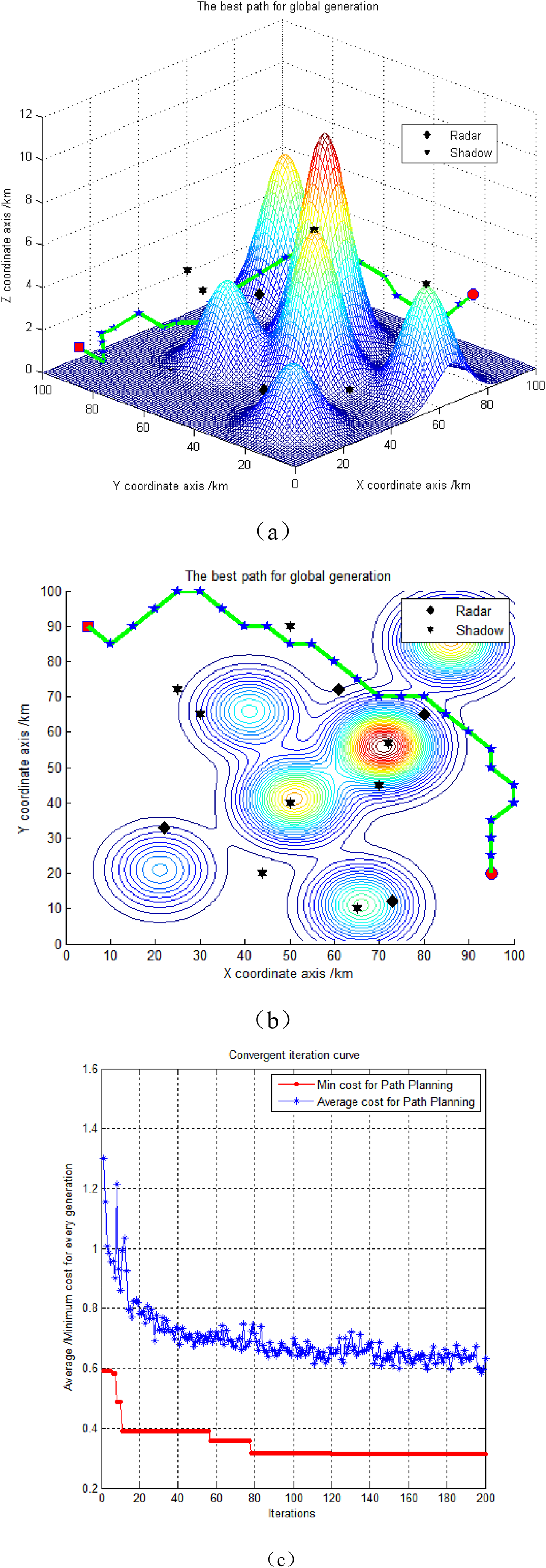
ES-TNF-ACO algorithm 3D track planning 3D diagram, contour plot and convergence curve (optimal value 0.3061, Q = 1).
It can be seen from Figure 4 that due to the large search range of three-dimensional space, if the target node factor is not introduced and the standard ant colony algorithm is directly adopted, the success rate of the algorithm reaching the target node is very low, that is, the predetermined task of track planning cannot be completed, so the target node factor must be introduced.
It can be seen from Figures 4, 5 and 6 that after the introduction of the target node factor, compared with the standard ant colony algorithm, the success rate of reaching the target node is very low, and the algorithm can reach the target node smoothly, but there is still the problem of the algorithm not convergence, and the randomness is strong.
It can be seen from Figures 8, 9 and 10 that on the basis of the TNF-ACO algorithm, the elite strategy is introduced, and the ES-TNF-ACO algorithm can converge every time and obtain better optimization results under the same Q parameters.
Table 2 shows the statistical analysis of the TNF-ACO algorithm and the improved algorithm ES-TNF-ACO with elite subgroups under the condition that different Q parameters are set. Q indicates the pheromone increase strength factor. Since the standard ACO algorithm does not reach the track target node, its statistics are of little practical significance. In the TNF-ACO algorithm and the improved ES-TNF-ACO algorithm, other parameter configurations are the same. According to Table 2, in Q = 10, Q = 5 and Q = 1, the ES-TNF-ACO algorithm has obvious advantages over the TNF-ACO algorithm, with 100 statistical data minimum, maximum, average, and variance, and 200 iterations in each loop, the former of which has better optimization effect than the latter. The results of 200 iterations of the optimal loop out of 100 cycles are shown in Figures 5, 6, 7, 8, 9 and 10.
3D spatial simulation data description statistics comparison of improved ACO algorithm.

It can be seen from Table 2 that the ES-TNF-ACO algorithm obtains better results than other parameters when Q = 1, and its optimization route and convergence curve are shown in Figure 10(c), with the continuous adjustment of iterations, the route cost gradually converges, and after 157 iterations, the cost converges to the minimum cost of the global route 0.3061, indicating that the algorithm is indeed effective and feasible. The radar, altitude, terrain shadow, cloud shading, terrain threat and fuel consumption costs of the route with the lowest cost were 0.0040, 46.9000, 11.1867, 0.2154, 4.7539 and 26, respectively, and the weighted costs were 0.0027, 0.1544, 0.0148, 0.0365, 0.0557 and 0.0420, respectively, for a total cost of 0.3061.
Conclusion
In order to solve the specific route planning problem of solar UAV, this paper proposes the TNF-ACO algorithm, and further improves the ES-TNF-ACO algorithm. In this paper, solar UAV flight at the equator position, at a certain point in the process of rising from the east, and simplifying the laying of solar cell wings to a flat installation, without considering the influence of the flight attitude of the aircraft itself, by establishing the model of mountain impact cost, height threat, mountain shadow shading cost, cloud shading cost, based on ant colony intelligent optimization algorithm, the ant colony path is reasonably constructed, and the maximum action distance of various costs. The constraints such as solar irradiation angle and effective action distance are introduced into the cost model and heuristic factor calculation, which solves the comprehensive optimization problem of solar UAV route planning. The simulation results show that the algorithm path structure is reasonable, the target node can be found independently, and the convergence speed can meet the requirements of route planning, and the generated route cost is small, which can be used for static planning design.
However, the algorithm only considers the laying of solar cells on the upper surface of the drone, and does not consider the laying of the lower surface. And when laying, it is simplified to horizontal plane calculation, and the level flight attitude is maintained when flying, and the situation of adjusting the flight attitude of UAV maneuvering is not taken into account. Therefore, the model still has certain limitations, and we will conduct in-depth research from the above mentioned areas later.
Finally, the potential application areas of the algorithm can be extended to solar airships, overpressure balloons and other fields.
Footnotes
Data availability
The data that support the findings of this study are available from the corresponding author upon reasonable request.
Declaration of conflicting interests
The authors declared no potential conflicts of interest with respect to the research, authorship and/or publication of this article.
Funding
The authors disclosed receipt of the following financial support for the research, authorship and/or publication of this article: This work was supported by the Hainan Provincial Natural Science Foundation of China (grant number 521RC496).
Author biographies
Zhonghua Hu is currently a senior engineer of the 38th Research Institute of China Electronics Technology Group Corporation. He received his PhD degree from Nanjing University of Aeronautics and Astronautics, Nanjing, China, in 2011. His research interests focus intelligent optimization algorithm.
Shihao Liu is currently a professor at School of Mechanical and Electrical Engineering, Hainan University, Haikou, China. He received his PhD degree from Nanjing University of Aeronautics and Astronautics, Nanjing, China, in 2013. His research interests focus optimization design approach.