
Abstract
Geothermal resources are green and environmentally friendly renewable energy. An accurate evaluation of geothermal resources will help subsequent efficient exploitation. However, to save costs and improve efficiency, core-free drilling and without mud logging are adopted in the actual exploration, which results in an inability to directly obtain the relevant evaluation parameters of a geothermal reservoir for exploration and evaluation. Well logging technology can effectively delineate the geothermal reservoir and determine the location of the major aquifer, while also allowing for the accurate measurement of key reservoir evaluation parameters, such as the shale content, porosity, and well temperature. Moreover, coupled with the calculated logging parameters, a volumetric method can be used to determine the regional geothermal reserves. This research takes the geothermal wells of the Guanghuasi Formation in the Qianjiang sag, Jianghan Basin as an example to conduct the application research. The findings can be of reference for similar geothermal wells in China and facilitate the development of “carbon neutrality.”
Introduction
Today, with the continuous decrease in fossil fuels and the increasing demand for energy, the energy issue has gained more and more attention from the international community. 1 Improving the current energy utilization efficiency and exploring renewable energy have become the two important approaches to address future energy issues. As clean energy, geothermal resources are characterized by large resource reserves, a wide distribution, cleanliness and environmental friendliness, good stability, and a high utilization rate. It is globally one of the most promising sustainable energy sources.
The total basic geothermal energy resources in the world are approximately 4.27 × 10¹⁶ t of standard coal,2,3 and geothermal energy reserves are mostly concentrated along the edges of tectonic plates and are relatively dispersed. China has abundant geothermal resources, accounting for approximately 1/6 of the global geothermal resources.4,5 Among them, shallow geothermal resources (buried within 200 m, with temperature <25°C) are widely distributed throughout the country, and the annual recoverable resources equivalent to 7 × 10⁸ t of standard coal. 5 Middle and deep geothermal resources in China are mainly concentrated in sedimentary rock reservoirs and are primarily of the hydrothermal type. 5 These resources are most commonly found in large sedimentary basins and mountainous fault belts. However, geothermal resources located in mountainous fault belts in China tend to be smaller in scale, while those located in sedimentary basins have favorable reservoir conditions, with greater thicknesses and a wider distribution. With increasing depth, the thermal storage temperature of these resources also increases, making sedimentary basins the areas with the greatest potential for geothermal resource development in China.
Most countries have set carbon neutrality goals and related policies.6,7 On September 22, 2020, Chinese President Xi Jinping solemnly announced China's “dual carbon” goal at the 75th United Nations General Assembly; Chinese CO2 emissions will aim to peak before 2030, and efforts will be made to achieve carbon neutrality by 2060. Exploring, developing, and utilizing geothermal resources can effectively help China achieve the goal of carbon neutrality. 8
As a green resource, geothermal resources can be used for geothermal heat pumps, floor heating, greenhouse heating, aquaculture, agricultural drying, industrial use, hot springs, refrigeration/snowmelt, and other applications.9–12 Proper exploration, development, and utilization of geothermal resources have good economic, social, and environmental benefits. To ensure the economic benefits of geothermal resources development, core-free drilling has been adopted in explorations and operations to save costs and improve efficiency, without conducting mud logging. As a result, the relevant parameters for evaluating geothermal water reservoirs cannot be directly obtained by experiment in the actual exploration and evaluation. Therefore, how to use well logging technology to do the division of a geothermal reservoir, determine the location of the major aquifer and obtain the shale content, porosity, permeability, water content, well temperature, and other related parameters of different layers have become an essential means for effectively exploiting geothermal water wells. Additionally, compared to core drilling and mud logging tests, well logging technology can provide continuous profiles of the relevant parameters of a drilled well; this technology can acquire abundant information, is low cost and has a wide coverage, thereby facilitating comprehensive and continuous reservoir evaluation.
In this research, 12 geothermal wells in the Guanghua oilfield in the Qianjiang sag, Qianjiang area, Jianghan Basin, Hubei Province, are researched. The evaluation effect of well logging technology in the geothermal reservoirs is analyzed, and the geothermal reserves and potential of the study area are described by using the volumetric method. The results of this study are expected to be a reference for other geothermal wells of the same type in China and facilitate the exploitation of “carbon neutrality” in China.
Characteristics of geothermal energy
According to geological structural characteristics, heat flow transmission patterns, temperature ranges, and exploitation and utilization models, geothermal resources can be divided into three types: shallow geothermal energy, hydrothermal geothermal energy (underground hot water), and hot dry rock.4,13
Shallow geothermal energy refers to geothermal resources at depths of <200 m below the earth's surface and a temperature lower than 25°C.14,15 In China, shallow geothermal energy is widely distributed throughout the country. Because of its shallow burial depth and easy exploitation, it can be used for heating and cooling.
Hydrothermal geothermal energy (underground hot water) is a middle to deep geothermal resource that is found deeper than shallow geothermal energy.16,17 The quantity of resources usually needs to be evaluated by geophysical well logging data to determine whether the resources have exploitation value. Underground hot water with different temperatures has different utilization modalities13,18,19: the underground hot water temperature greater 92°C, it can be used for geothermal power generation; that is, geothermal water is put through the flash evaporator to generate steam and then propel a steam turbine for power generation to provide electricity for residents; for temperature in the range of 75°C to 92°C, it can be used for geothermal refrigeration; for the temperature in the range of 55°C to 70°C, it can be used for geothermal drying; and for the temperature in the range of 35°C to 55°C, it can be used for geothermal heating and geothermal bathing.
Hot dry rock is also classified as a type of middle and deep geothermal resource. Unlike hydrothermal geothermal resources, hot dry rock is a high-temperature rock layer with no internal fluids or only a small amount of underground fluids (dense and impermeable water).19–21 Due to the lack of fluid and its deep burial depth, heat exchange can be achieved only through ultra-long buried pipes. This process requires not only horizontal drilling, fracturing technology, and new efficient heat transfer materials, but also considerations for the heat loss during ultra-long distance underground transport. At present, there is no advanced exploitation technology for hot dry rock in China.
Geological setting and well logging evaluation techniques in the study area
Geological setting
The Jianghan Basin is located in the central and southern part of Hubei Province. It is composed of seven relatively independent secondary sags and four low swells between sags. 22 The Qianjiang sag is located in the middle of the Jianghan Basin (Figure 1), with an area of 2550 km2. The study area is located in the Wang-Guang fault belt in the northern Qianjiang sag, Jianghan Basin. Exploration practice and geothermal evaluation in the study area show that there are four sets of geothermal sedimentary reservoirs in the Wang-Guang-Hao fault belt, namely, Palaeogene Qianjiang Formation, Palaeogene Jinghezhen Formation, Neogene Guanghuasi Formation, and Quaternary Pingyuan Formation. Among these formations, the Guanghuasi Formation is relatively shallow, with a large water volume and low salinity, making it the optimal reservoir of the four sets of geothermal reservoirs (Figure 2).

Structural diagram of the Jianghan Basin.

Stratigraphic profile of Well DXR1.
The Neogene Guanghuasi Formation is a clastic sedimentary formation consisting of fluvial and flood plain facies, which developed during the depression stage of the basin. The lithology of this formation is a uniform thickness interbedded strata of gray-green, gray mudstone, and gray-yellow, gray-green siltstone, fine sandstone, coarse sandstone, and gravel sandstone. The Guanghuasi Formation is typically 80 to 1000 m deep, and according to the differences in lithology, it can be divided vertically from top to bottom into the Guang-1, Guang-2, and Guang-3 members. The Guang-2 member, primarily developing 4 sets of channel sands, is typically found at depths of 450 to 900 m with an effective thickness of 150 to 200 m (Figure 2). The pore types of these channel sands are dominated by original intergranular pores. The majority of the reservoirs in the Guang-2 member are highly porous and highly permeable, with porosities ranging from 25.8% to 42.0%, permeabilities ranging from 295.1 × 10⁻³ to 21050.0 × 10−3 μm2 and mineralization degrees ranging from 600 to 1000 mg/L. The Guang-2 member sandstone is an ideal hydrothermal geothermal reservoir, with a shallow burial depth, good permeability, and effective caprock thickness.
Well logging evaluation of geothermal resources
Well logging technology is an important means to discover and evaluate geothermal reservoirs. While it may be an indirect method for studying the geological characteristics of rock formations, it allows for the acquisition of continuous stratigraphic profile information in a short time. In addition, in the absence of mud logging and core data, well logging becomes the primary method for formation detection and plays a critical role in the exploration of geothermal resources.
Well logging suites and main functions
The layers measured in the study area are mainly interbedded with sandstones and mudstones, in which conventional electric logging suites in geothermal wells are used. The logging suites include natural gamma ray (GR), spontaneous potential (SP), resistivity (Rt), acoustic slowness (AC), well temperature, and caliper (CAL) logs (Table 1).
Division of permeable layers
Main functions of electric logging suites in geothermal water wells.

The accurate division of aquifers and aquicludes, determination of horizons and thickness are crucial in the reservoir evaluation of geothermal water wells. In general, the Rt, GR and SP of the well-permeable layer are lower than those of the poorly permeable layer.
2. Classification of stratigraphic lithologies 3. Estimation of the outlet water temperature 4. Determination of the formation mineralization degree
There are certain differences in the physical properties of different rocks, or the same rock with different particle sizes, and the lithology of the formation can be delineated by using these differences in physical properties. Sandstone is primarily composed of high-Rt minerals such as quartz and mica, resulting in higher apparent Rt values and anomaly peaks in the apparent Rt curve. Clay layers indicate low anomaly values, and water-bearing sandstone layers are lower in radioactivity contents relative to other layers, featuring low GR values.
The subsurface temperature increases with increasing well depth, and the log temperature curve shows that the temperature also increases gradually with increasing well depth. Based on the well temperature curve, the temperature value at a given depth can be determined. Considering the heat consumption of steel pipes during pumping, the outlet water temperature can be estimated.
The SP and apparent Rt anomalies are directly related to the mineralization degree of well fluids and formation water. In general, when the mineralization degree of well fluids is higher than that of formation water, the SP shows a positive anomaly. When the salinity of well fluids is equal to the salinity of formation water, the SP tends to be saturated and appears as a straight line. When the mineralization degree of well fluids is less than that of formation water, the SP shows a negative anomaly. The greater the difference between the mineralization degree of the well fluids and the formation water, the more significant the SP anomalies. The higher the mineralization degree is, the greater the metal corrosion, so it is of certain practical significance to estimate the range of mineralization degrees for the exploitation of geothermal wells.
Determination of reservoir evaluation parameters
In addition to qualitatively analyzing geothermal wells, well logging technology can be used to quantitatively obtain reservoir evaluation parameters, such as the shale content and porosity to further evaluate geothermal resources.
(1) The shale content is a very important parameter for evaluating clastic rock layers. A justifiable calculation of the shale content is helpful for calculating of other reservoir parameters. The GR is usually used to calculate the shale content:

(2) Porosity is the most important parameter in reservoir evaluation. Usually, acoustic slowness logging is used to calculate reservoir porosity. Since the reservoir is an argillaceous sandstone reservoir, an argillaceous correction is needed.
Calculation method for geothermal resources
In the China National Standard of Geologic Exploration Standard of Geothermal Resources (GBT11615-2010), methods for calculating geothermal resources include the volumetric method, surface heat flux method, analytical method, and statistical method. The volumetric method, also known as the geothermal resource method, is used to calculate the heat stored in thermal reservoirs and estimate the potential of geothermal resources in a geothermal field. 22 This method is suitable for large-pore geothermal reservoirs and is generally used to evaluate sedimentary basin-type geothermal resources.
The equation for calculating the volumetric method:
The equation for calculating the average specific heat capacity (
The equation for calculating the recoverable geothermal resources is as follows:
where QE is the recoverable geothermal resources (heat from the wellhead), J; RE the thermal energy recovery, %.
Case study
Evaluation of the single-well geothermal resource
Well CJR2 in the study area serves as an example for the analysis. The outlet water was mainly located in the Guang-2 member, which is composed of glutenites interbedded with mudstones. This member is characterized by secondary low GR curves, SP negative anomalies (influenced by the difference in the fluid mineralization degree and formation water mineralization degree), significant hole enlargement with the CAL curve, relatively high values for the 2.5 m Rt and deep/shallow dual laterolog Rt (LLD/LLS) curves, and slightly higher values for the AC curves relative to the surrounding rocks. The well temperature curve followed the trend of the geothermal gradient and varied according to the outlet water of the formation. The mudstone was characterized by high GR values, low anomalies of the SP curve amplitude, slight hole enlargement with caliper curves, relatively low Rt, slightly decreased AC values, and a well temperature curve that follows the trend of the geothermal gradient (Figure 3).

Comprehensive interpreted log of Well CJR2.
Basis for aquifer division
The geothermal reservoir with the most detailed and comprehensive evaluation in this area is the Guang-2 member of the Neogene Guanghuasi Formation. The aquifer in the Guang-2 member of the Guanghuasi Formation features low GR values (approximately 40 API), AC values in the range of 450 to 480 μs/m, the LLD/LLS values in the range of 11.0 to 20.0 Ω.m, shale contents in the range of 10% to 20%, and porosity values in the range of 35.0% to 40.0% (Figure 3).
The well logging curve reveals that the reservoir has pure lithology, good physical property, and significant aquifer characteristics, and thus, the reservoir can be comprehensively interpreted as a water layer. The GR, SP, AC, and LLD/LLS curves are all used to make stratigraphic divisions at the half-amplitude points of the curves, with other curves as supplementary. Moreover, the caliper curve has obvious variations, indicating that the reservoir is relatively loose with good permeability, and can be identified as water-bearing sandstone.
Estimation of the outlet water temperature
Taking Well CJR2 as an example, the well temperature log was evaluated in an interval of 0.0 to 650.0 m (Figure 4), and the temperature data showed that the wellhead formation temperature was 30.63°C and the bottom formation temperature was 45.05°C.

Well temperature versus depth in Well CJR2.
Figure 4 shows that there are two obvious linear relationships between the well temperature and depth. After linear regression analysis, the relationship between the well temperature and depth can be obtained by using the principle of the highest correlation coefficient.
The relationship between the well temperature and depth in the interval of 0.0 to 175.0 m in the geothermal reservoir is as follows:

where Tr is the geothermal reservoir temperature, °C; Dr the geothermal reservoir depth, m.
The relationship between the well temperature and depth in the interval of 175.0 to 650.0 m in the geothermal reservoir is as follows:

According to the geothermal well logging data, the temperature value at a given depth can be determined. The data show that the average geothermal temperature in the aquifer of Well CJR2 is approximately 40°C. Considering the heat consumption of steel pipes during pumping, the outlet water temperature is estimated to be approximately 30°C to 35°C. The total thickness of the aquifer is approximately 151 m. Combined with the regional hydrogeological conditions, the single-well water flow rate was calculated as 135.9 m3/h according to the empirical value of 0.9 m3/h per meter. The results of the pumping test show that, excluding the effect of drawdown, the actual water output is 132m3/h, and the water temperature at the wellhead is 32°C.
Calculation of geothermal resources in the study area
The heat storage area (A) in the study area is approximately 49.9 km2. The average thickness of the thermal reservoir in the Guanghuashi Formation is 115 m. According to years of geothermal monitoring data, the depth of the constant temperature zone in the Jianghan Basin is 25 m, the base temperature (Tj) is 14.9°C, and the thermal reservoir water temperature of the Guanghuasi Formation (Tr) is approximately 40.1°C.
According to logging data, the rock density (ρc) of a sandstone reservoir in the Guanghuasi Formation is 2.25 g/cm3 (2250 kg/m3), and the average porosity (φ) of the Guanghuasi Formation is 37.5%. According to the sampling analysis, the density (ρw) of geothermal water in the study area is 972.7 kg/m3; the specific heat capacity (Cw) of geothermal water is 4185.4 J/(kg·°C); and the specific heat capacity of sandstone is 878.0 J/(kg·°C). According to equations (4) and (5), the geothermal reserves of the Guanghuasi Formation in the Qianjiang sag are calculated to be 3.99 × 10⁸ GJ, presenting a large overall geothermal resource exploitation potential.
In addition, according to the China National Standard of Geologic Exploration Standard of Geothermal Resources (GBT11615-2010), for Cenozoic sandstones in large sedimentary basins, when the porosity is >20%, the thermal energy recovery rate (RE) is 25%. Based on equation (6), the recoverable geothermal resources of the Guanghuasi Formation in the study area can be calculated as 9.98 × 10⁷ GJ, which is approximating 3.53 × 10⁸ t of standard coal. The overall environmental benefits are significant, which can facilitate China's goal of “carbon neutrality.”
Regional comparison
Regarding the study area, four aquifers were present in the Guang-2 member, and the first, third, and fourth sets were stable. The second set of aquifer was not developed in some local areas. In the study area, a total of 12 geothermal water wells, including Well CJR2, were drilled in the Guang-2 member. The depth, thickness, and temperature of the thermal water layer in the Guang-2 member were analyzed using well logging technology in these 12 geothermal water wells (see the Supplemental material). The contour map of the thicknesses of the four aquifers in the Guang-2 member in the 12 wells was made using the Kriging interpolation method (Figure 5); the redder the color, the thicker the aquifer is.
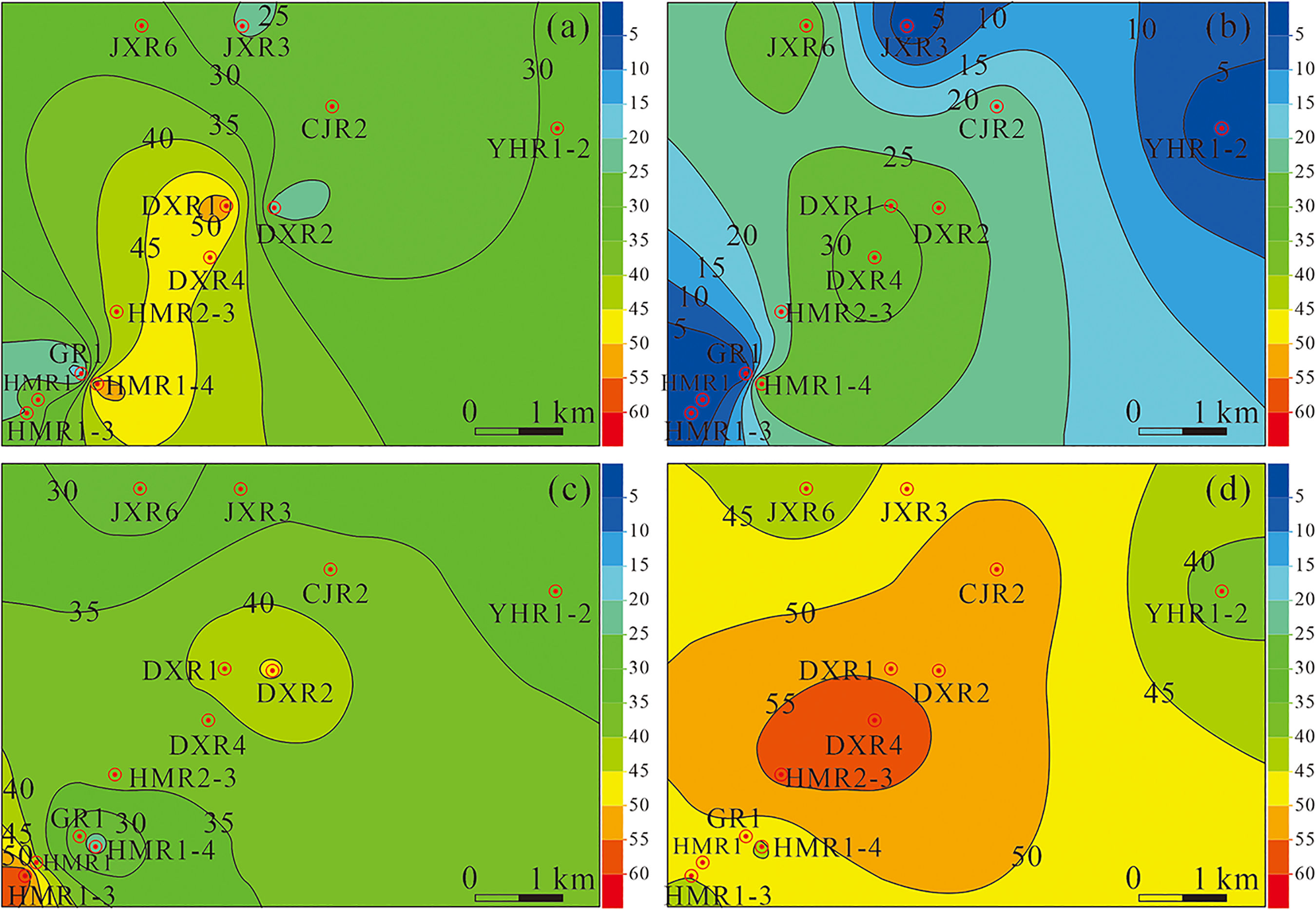
Contour map of the thicknesses of four sets of aquifers in the Guang-2 member: (a) first set, (b) second set, (c) third set, and (d) fourth set.
As shown in Figure 5, the four sets of aquifers in the Guang-2 member all show the regional characteristics of thick in the middle and thin along the edge. The third and fourth sets of aquifers feature uniform thickness distributions, and these aquifers can be used as the major production layers of geothermal wells.
The temperature contour map (Figure 6) mainly shows the fourth set of aquifers in the Guang-2 member. The water temperature in the northern part of the fourth set of aquifers in the Guang-2 member is 3°C to 4°C higher than that in the southern part. Coupled with the thickness and temperature contour map, the geothermal wells in the CJ and DX blocks have the best effect.
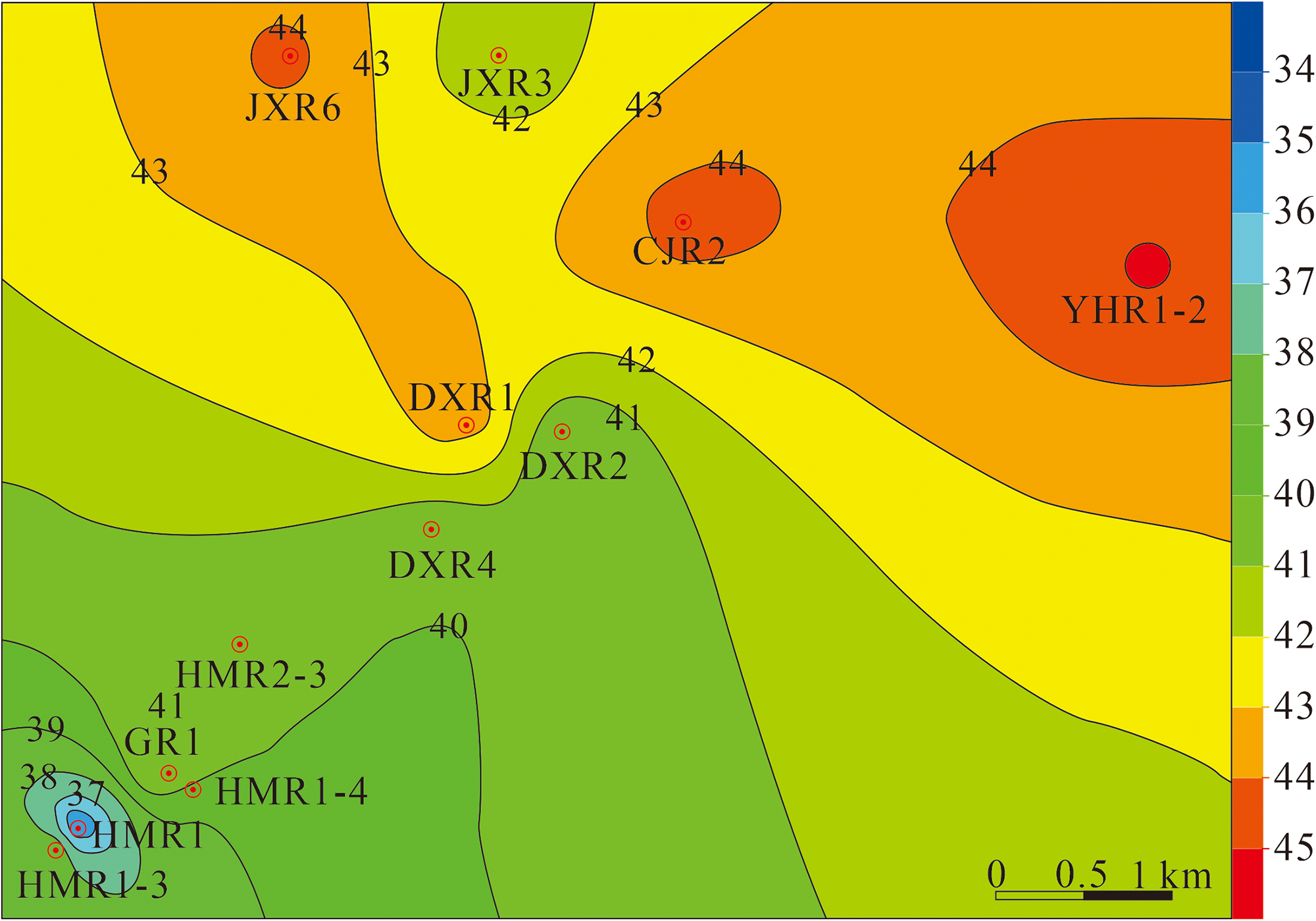
Temperature contour map of the fourth set of aquifers in the Guang-2 member.
The well logging data predicted that the water temperatures at the wellheads of 12 geothermal wells would be between 30°C and 36°C, and the actual water temperatures were within the predicted range (Table 2). Moreover, the predicted average flow rate of a single well was 131.1 m3/h, while the measured flow rates ranged between 110.5 and 138.6 m3/h, with an average of 129.1 m3/h and a maximum relative error of <5.0%. These findings suggest that evaluating geothermal wells using logging data yields favorable results.
Comparison between well logging predictions and actual production of 12 geothermal wells.

Discussion
Application of well logging data
Well logging data such as GR, SP, Rt, AC, well temperature, and CAL, can provide crucial information about the reservoir conditions of geothermal wells and serve as a basis for the exploitation of geothermal resources. However, the application of logging data is not limited to this stage of exploration. After the geothermal reservoir is developed, a production profile logging can be undertaken to gather GR, magnetic positioning, pressure, reservoir flow rate, water holdup, and gas holdup data.23,24
According to the suites of production profile logging, the water production of each thermal reservoir can be evaluated. Additionally, the temperature curve can also be used to determine the damaged position of the well pipe in the geothermal well, which can assist in developing the production plan and program to exploit the geothermal well resources in a proper manner.
The application of well logging data runs through the exploration and development of geothermal wells. Rational use of well logging data can facilitate the development of geothermal resources and contribute to the promotion of “carbon neutrality.”
Prospects of geothermal resources exploration and development technology
Compared with wind and solar energy, geothermal energy is a safe and reliable green energy resource that is not affected by seasonal, climatic, and geographical factors. 20 When exploited appropriately, geothermal energy can reduce the reliance on traditional fossil fuels and aid in the achievement of China's “double carbon” goal (carbon peaking by 2030 and carbon neutrality by 2060). Nevertheless, China is currently facing bottlenecks in key technologies for geothermal energy exploration and development.
The key technological for the exploration and development of deep geothermal resources, construction of geothermal wells, and heat storage transformation are still in the initial stage in China. There is no full-fledged “heat-search” technology, and there is a lack of systematic technology to detect geothermal resources (drilling, well logging, cementing, etc.). There is also a lack of large-scale efficient surface utilization technologies, such as power generation facilities, cascade utilization, anticorrosion, and scale prevention. Many technologies need to be researched and addressed. For well logging technology, establishing a comprehensive evaluation system for geothermal aquifers and researching efficient and stable logging tools under high-temperature conditions will be important future directions for development in the future.
Conclusion
Geothermal reservoir evaluation can be effectively performed using well logging technology, without the need for core drilling and mud logging. Based on a study of well logging technology in geothermal water wells within the Neogene Guanghuasi Formation in the Jianghan Basin, the following conclusions have been drawn:
The geothermal resources of the Neogene Guanghuasi Formation in the Jianghan Basin are hydrothermal geothermal resources. Well logging data and technical analysis can be used to classify geothermal reservoirs, determine their lithologies, and locate major aquifers. In addition, by calculating relevant parameters, the key indicators such as shale content, porosity, permeability, water content, and well temperature of different layers can be obtained. According to the well logging analysis, the sandstone in the Guang-2 member is an ideal hydrothermal geothermal reservoir with shallow burial, good permeability, and effective caprock thickness. The geothermal reserves of the Guanghuasi Formation in the study area were analyzed by the volumetric method. The geothermal resources are 3.99 × 10⁸ GJ, the recoverable resources are 9.98 × 10⁷ GJ, which are equivalent to 3.53 × 10⁸ t of standard coal, and the overall exploitation potential of geothermal resources is large. With proper development, geothermal energy can help support China's goal of achieving “carbon neutrality.” Based on regional comparison, the four sets of aquifers in the Guang-2 member exhibit a pattern of thick in the middle and thin on the edges, while the third, and fourth sets of aquifers have even thickness distributions. The water temperatures in the northern part of the fourth set of aquifers in the Guang-2 member are 3°C to 4°C higher than those in the southern part. Combined with the thickness and temperature contour maps, the geothermal wells in the CJ and DX blocks have the best effect. In terms of well logging technology, establishing a comprehensive evaluation system for geothermal water layers and research on efficient and stable logging tools under high-temperature conditions will be the primary direction for the exploration and exploitation of geothermal resources in the future.
Supplemental Material
sj-doc-1-sci-10.1177_00368504231183587 - Supplemental material for Application of well logging technology in geothermal resource evaluation: A case study of geothermal water wells in the Qianjiang sag, Jianghan Basin
Supplemental material, sj-doc-1-sci-10.1177_00368504231183587 for Application of well logging technology in geothermal resource evaluation: A case study of geothermal water wells in the Qianjiang sag, Jianghan Basin by Wenrui Shi, Lijuan Ma, Zisang Huang, Ganlu Wang, Chengfang Wang, Lijun Li, Yunjing Ji, Liu Liu and Chang Xiao in Science Progress
Footnotes
Declaration of conflicting interests
The author(s) declared no potential conflicts of interest with respect to the research, authorship, and/or publication of this article.
Funding
The author(s) disclosed receipt of the following financial support for the research, authorship, and/or publication of this article: This work was supported by the Open Foundation of Cooperative Innovation Center of Unconventional Oil and Gas, Yangtze University (Ministry of Education & Hubei Province) (grant number UOG2022-21), Green Enterprise Creation Project of Sinopec Matrix Corporation (grant number 202203).
Supplemental material
Supplemental material for this article is available online.
Author biographies
Wenrui Shi is a Lecturer at Yangtze University. His research interests include geology, logging interpretation and evaluation, engineering development, and environmental protection of shale gas.
Lijuan Ma is a senior engineer at Sinopec Matrix Corporation. Her current research interests include geothermal energy exploration and development, logging engineering technology.
Zisang Huang is a Lecturer at Chengdu University of Technology. His current research interests include shale gas reservoir evaluation, geothermal resources geologic evaluation.
Ganlu Wang is an Associate Professor at Guizhou University. His main research interests include unconventional oil and gas geological evaluation, water resource assessment.
Chengfang Wang is a senior engineer at Sinopec Matrix Corporation. Her current research interests include geothermal energy exploration and development. Lijun Li is a senior engineer at Sinopec Matrix Corporation. His current research interests include logging engineering technology.
Yunjing Ji is a senior engineer at Sinopec Matrix Corporation. His current research interests include logging engineering technology, unconventional oil and gas development.
Liu Liu is a engineer at the exploration department of Jianghan Oilfield Branch Company in Sinopec. His current research interests include geothermal resources geologic evaluation, unconventional oil and gas development.
Chang Xiao a Lecturer at Yangtze University. Her research interests include geology, logging interpretation and evaluation.
References
Supplementary Material
Please find the following supplemental material available below.
For Open Access articles published under a Creative Commons License, all supplemental material carries the same license as the article it is associated with.
For non-Open Access articles published, all supplemental material carries a non-exclusive license, and permission requests for re-use of supplemental material or any part of supplemental material shall be sent directly to the copyright owner as specified in the copyright notice associated with the article.