
Abstract
Cities are vulnerable to a range of disasters that can occur simultaneously due to their complexity. Therefore, an effective disaster response plan is needed to reduce the disaster vulnerability of cities. In particular, evacuation route management is important for reducing the losses from a disaster. Efficient disaster response can be realized by searching for suitable evacuation routes and effective road network management. In this paper, we propose a disaster response framework based on a multilayered road network structure and evacuation routes based on our road network. The suggested road structure consists of three layers for the effective management of the network. An A* algorithm-based search for multiple evacuation routes under different conditions in response to an individual disaster on the configured road map provides a safe route for evacuees. As a result, the damage caused by disasters in urban areas can be ameliorated.
Introduction
In modern society, complex disasters in which natural hazards and social disasters combine are becoming increasingly common. 1 Natural hazards can be defined as a combination of natural phenomena and vulnerabilities, causing significant environmental, economic, and social damage. 2 This damage caused by natural hazards can be classified into direct and indirect losses. 3 Direct losses occur immediately after an event, such as the destruction of roads or buildings due to an earthquake and the loss of bridges due to flooding. Indirect losses refer to the disruption of social services and functions. For example, when a bridge is submerged due to heavy rain, traffic is delayed or rerouted, which can disrupt the activity of individuals, businesses, and public services such as fire and police departments. In addition, a secondary disaster is often caused by a primary disaster, such as a tsunami or landslide resulting from an earthquake. 4 In Korea, a social disaster is defined as damage caused by fire, collapse, explosion, and traffic accident and includes damage caused by paralysis of the national infrastructure system such as energy, communication, transportation, finance, and medical care. 5
Due to the recent rapid changes in the climate, the frequency of severe natural hazards is increased. In addition, as the connectivity between regions increases, the possibility of a disaster in one region being linked to another and developing into a more complex disaster is increased. 6 Complex disasters begin with natural hazards that cause simultaneous social disasters and consequent large-scale social damage that requires long-term restoration. Cities are particularly vulnerable to complex disasters due to the complexity of their systems and structures. 7 Therefore, effective disaster response methods are needed to prevent a chain reaction of complex disasters and reduce vulnerabilities to urban disasters.
Modern society is planned around cities, which are composed of a network centered on roads. Therefore, a disaster response should be planned around the traffic management of the road network. 8 Road-network-centered disaster response approaches determine evacuation routes using route search methods and optimizing the road network configuration, which can prevent indirect losses from natural hazards. 9 In disaster situations, decision-makers determine the optimal evacuation policy to move people from dangerous areas to safe areas with route-searching methods. 10 Traditional search techniques for evacuation routes focus on geographic proximity and the shortest travel time. 11 However, when navigating a route in an actual disaster situation, it is necessary to avoid associated dangers to ensure the safety of evacuees. In addition, road networks are the backbone of modern cities, enabling the movement of assets and people, and are a rich source of geographic information for a city.12,13 The damage to roads during a disaster greatly affects the overall social system.14–16 Therefore, disaster evacuation route management can be effectively conducted by improving the road network configuration.17,18
In this paper, we design a multilayered road network that contains the information necessary for a disaster response that can reduce disaster losses. We present a disaster evacuation framework that identifies safe routes to shelters that avoid hazardous areas within the constructed road network. The proposed method can accurately detect and avoid disaster zones based on spatial information for the roads and search for evacuation routes during a complex disaster. Our method can thus prevent secondary damage such as traffic accidents by reducing traffic congestion during the evacuation process by distributing appropriate personnel to various shelters through multiple routes. We demonstrate through case studies that the proposed method can reduce the damage incurred from complex disasters.
The structure of the remainder of the paper is as follows. “Related work” section summarizes past studies related to disaster response. “A complex disaster response framework” section then presents road network reconstruction and disaster evacuation route search techniques, while “Empirical analysis” section describes the results of experiments to demonstrate the effectiveness of the proposed disaster response approach. The conclusions and implications of the study are presented in “Discussion” section.
Related work
There are simulation-based studies for disaster responses. Quagliarini et al. 19 conducted flooding simulations by comparing simulation models based on a microscopic approach. In a study by Mostafavi and Ganapati, 20 various engineering, sociology, and dynamic perspectives of disasters were considered by integrating theoretical elements from various domains. The researchers proposed simulation-based research on these perspectives. Yang et al. 21 modeled various evacuation center distributions and pedestrian types for the selection of evacuation routes for pedestrians during heavy rain in a city. Li et al. 22 present an emergency mobile facility (EMF) routing model based on an abstract description of emergency events to provide an effective method for solving the EMF routing problem and construct a strongly connected graph of all roads near the venues and plan a one-way orientation for all roads for the rapid evacuation of participants.
Researchers studied adopting big data on urban disasters. Guo et al. 23 developed an information system for evaluating the economic loss of cities due to heavy rain disasters through data collection and established measures to prevent economic loss due to disasters. Lin et al. 24 explored a study to reduce the damage suffered by flood victims by predicting the dynamic demand for relief supplies based on big data. Shan et al. 25 presented a model that combines Natural Language Processing and statistical methods and monitors and evaluates disaster damage in real time using information from social media.
The importance of road network repair and restoration is also highlighted in disaster response. 26 Akbari and salman 27 developed the exact Mixed Integer Program and the mathematical method and reconnect the components of the road network after a disaster. Çelik et al. 28 defined the debris clearance problem and presented a process model to solve this problem and test the optimal road debris removal performance. Almeida et al. 29 analyzed the damage to the supply chain that delivers relief goods with past hurricane data and presented a decision support model in disaster situations.
Other disaster response studies focus on route planning. The capacity-constrained route planner (CCRP) is an evacuation-planning algorithm that models road capacity over time and applies capacity-limited routing approaches to constrain the capacity of a route, reducing the time required to derive solutions. 30 Kim et al. 31 sought to reduce the computational time for the CCRP by proposing a scalable heuristic for large networks. In the study by Herschelman and Yang, 32 they adopted a suffix tree to reduce the evacuation time and minimize conflicts between various routes. Hsieh et al. 33 construct a strongly connected graph of all roads near the venues and plan a one-way orientation for all roads for the rapid evacuation of participants. Liu et al. 34 proposed a location-based intelligent route planning service using the G*tree structure, an improved version of the G tree structure. Kim et al. 35 constructed a GIS-based road network that retains road distance information and plans evacuation routes based on the A* algorithm.
Shortest-path searches are frequently studied in computer science, especially graph theory. The optimal shortest path represents the minimum distance from the source to a target destination. 36 Potamias et al. 37 presented a landmark-based method to estimate the distance between points in a large network, while Hu et al. 38 searched for an optimal path based on random walks in a graph. In addition, Honiden et al. 39 derived the shortest path from an undirected graph based on random sampling.
Many studies employed Dijkstra-based algorithms such as the A* algorithm when searching for the shortest path. 40 Chao 41 studied how to find the shortest paths in directional and dynamic graphs using Dijkstra and data-reduction techniques. Kaleeswari et al. 42 improved the data structure for Dijkstra-based path-search algorithms and improves the storage efficiency by setting the search area sequences. Sabri et al. 43 explored safe evacuation routes based on a Dijkstra algorithm in a vertical route search process when an accident occurred within a building. Researchers44–46 explored evacuation routes for tsunamis based on BFS, A*, and Dijkstra algorithms.
In previous work, 35 we proposed a road network reconstruction framework for disaster evacuation planning. We studied graph-based road network generalization that considered various disaster risk factors based on public data. In this paper, we explore the generalized road network further by expanding it into a multilayered structure to better reflect a disaster situation and the functional aspects of the roads. In our network, we execute a route search that avoids disaster risks by considering the conditions and risks for specific disasters. Our approach has the potential to reduce damage by reducing the confusion during evacuation by offering multiple evacuation routes that consider the number of evacuees and the capacity of the surrounding shelters.
A complex disaster response framework
In this paper, we present a framework that can respond to complex disasters with the aim to minimize damage. Figure 1 presents an overview of the proposed framework. We construct a multilayered road network that includes information required for the disaster response. Our approach reduces indirect damage by planning evacuation routes that consider the characteristics and situational information for specific disasters.

Overview of the complex disaster response framework.
Multilayered road network reconfiguration
Design of multilayered road networks
A physical road can be characterized by a diverse range of features, such as its width and length, the surrounding buildings, and its geographical features. Therefore, the complexity of a road network increases when the physical roads therein are represented as a single layer. Networks with high complexity are difficult to manage because the entire network structure must be reconstructed in the event of changes to some of its components. In this paper, we present a multilayered road network model that can effectively manage changes in the road structure (e.g. new or extended roads) and disaster-specific conditions (e.g. spatial hazards and changes in evacuation sites). The proposed model consists of three layers: the GIS-based road network, disaster information, and safety zones.
Figure 2 illustrates the structure of the proposed road network model. The GIS-based road network layer includes spatial information, including the road address, a road identification ID, latitude and longitude coordinates, the road length, and the road width. The disaster information layer contains spatial information about the areas directly affected by disasters, while the safety zone layer consists of information about shelters and hospitals (e.g. their capacity, road address, and coordinates). A road network that connects several layers can effectively express complex information. 47 We thus represent the entire road network by connecting the constructed layers. The GIS-based road network layer and the disaster information layer are connected as overlapping areas based on their location information. The GIS-based road network and safety zone layer are connected by matching a shelter/hospital to the nearest road segment based on their location information. This modular data management allows us to accurately adjust information without changing the overall structure of the model.

Structure of the proposed multilayered road network.
Road segment–based disaster recognition
Generally, we can find a destination through location-based or logical-path searches on a generalized graph. However, in the real world, most roads have irregular physical connections. Therefore, in an actual disaster evacuation, we should consider the irregularities of the roads and their geometric features. In this paper, we propose a route-planning method that searches for safe routes using road network generalization that avoids unexpected road risks. Existing node-based maps 48 represent roads as edges that only represent connectivity between nodes. However, these edges do not necessarily reflect the actual road shape, and it is difficult to identify routes that pass through dangerous areas. Figure 3(a) presents roads and disaster-related areas of damage on a physical road map. The roads are represented by black lines, and the damaged area is the shaded blue area. Figure 3(b) and Figure 3(c) transform the map in Figure 3(a) to a point-based and a GIS-based map, respectively. As shown in Figure 3(b), when the roads are expressed as an edge, it is difficult to identify routes with a disaster risk because the location information for the roads is lost. On the other hand, our method preserves the location information for the roads and can effectively search for road segments that pass through the areas directly affected by disasters.
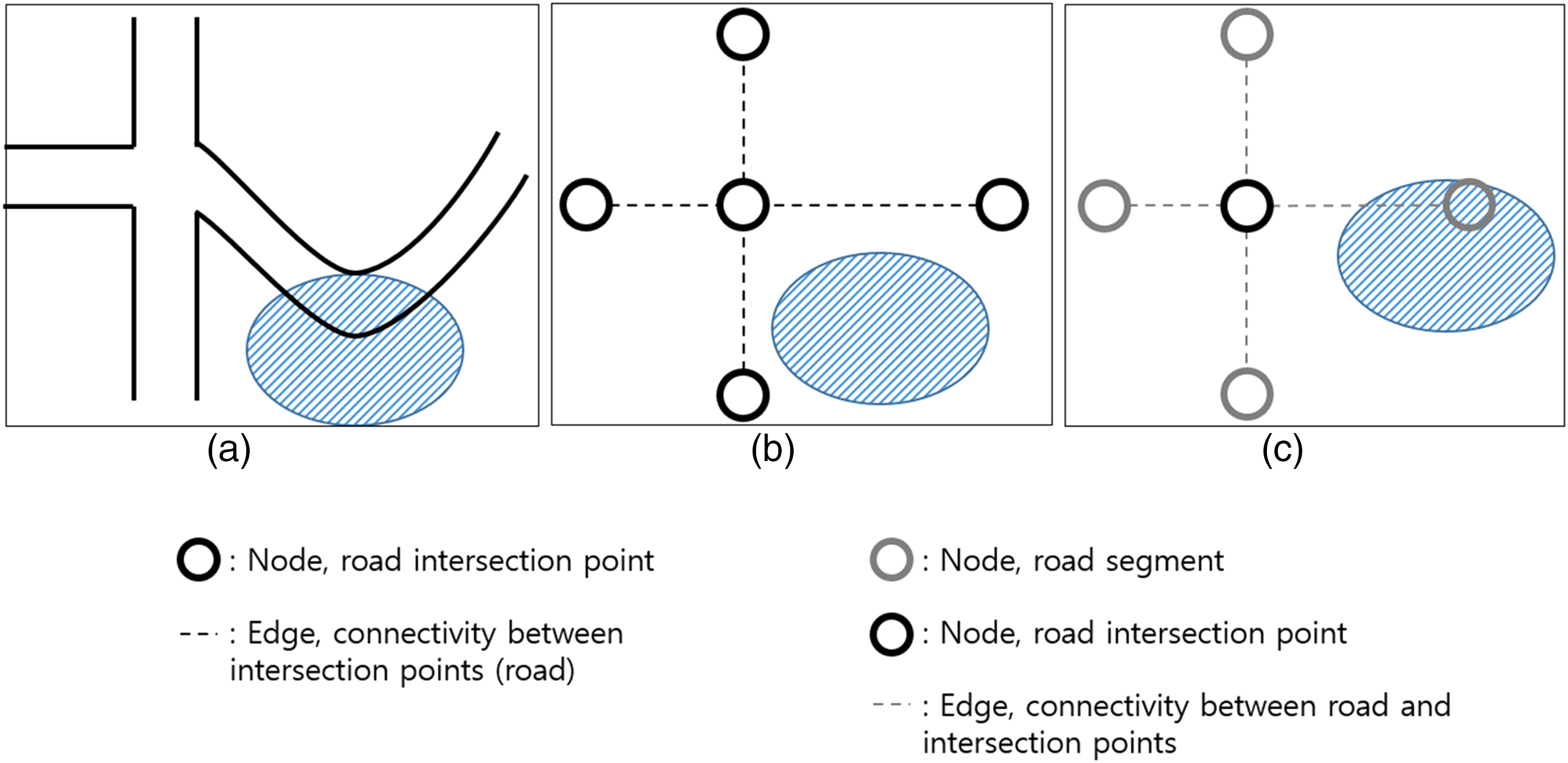
(a) Physical road map, (b) a map representing roads as edges representing connectivity between nodes, and (c) a map preserving the spatial information for the roads.
Disaster response for a complex disaster
We derive the shortest path from an arbitrary starting point to a safe place using the A* algorithm. The A* algorithm finds the shortest path between two points based on heuristic information, and the cost function is as follows:

In our method, g(n) is calculated as the sum of the road lengths on the route to the current point, and h(n) is calculated using the Haversine formula. The cost is defined as the evacuation time considering the total travel distance. The proposed method avoids disaster risk areas by assigning a weighted r to h(n), a heuristic function of the existing expression. r is employed for disaster identification and represents roads damaged by the disaster. We specify the roads with a disaster risk by mapping the location information of the area directly affected by the disaster and the GIS information of the road. When the value of r is 1, they are normal roads. Besides r is greater than 1, it means that roads are exposed to disaster risk. As the risk increases, the cost of any route passing these roads also increases. Therefore, roads with a disaster risk are excluded from the route-search process. The extent and type of damage and the areas in which it occurs differ for different types of disasters. Therefore, the value of r is adjusted for each disaster. The value of r is summarized as follows according to the risk level of the roads:

Pseudocode for the multiple evacuation route-searching algorithm.

Empirical analysis
Implementation
In this paper, we adopt the Quantum Geographic Information System (QGIS), an open source–based Geographic Information System (GIS) analysis tool, to construct the road layer containing spatial information. 28 We generate a road segment by dividing the roads according to the road names based on the intersections between the roads. A road segment is identified using an ID generated through the hashing of the road length and the road name. We then construct a disaster information layer containing the locations of the disaster areas. The proposed approach generates the GIS-based road layer with spatial information by storing the road name, width, length, and coordinates of its end-point nodes. Roads included in the disaster areas are extracted using geographic information for the disaster areas and the cross-region function of the QGIS, and disaster identifiers are assigned to them. The disaster information layer and the GIS-based road network layer are connected by matching the IDs to those roads to which disaster identifiers are assigned. Finally, we create a safety zone layer that stores information about the shelters and hospitals using public data. The safety zone layer is connected to the road network layer by matching the road section closest to the shelter.
Case studies
We explore case studies for an earthquake and flooding to prove that our proposed framework is suitable for disaster response. In Korea, earthquakes caused significant damage to urban structures in recent years and preparations are needed for future events. Urban flooding occurs frequently during the rainy season in Korea, and it represents the most significant form of natural hazard in Korea over the last decade. 51 Flooding causes physical damage to roads, resulting in traffic jams and accidents.52,53 In this paper, we consider areas that are frequently exposed to or expected to be at risk from earthquakes and/or flood damage and to experience complex damage patterns and consequently decide to conduct the evacuation route planning demonstration in Busan which is a city with an area of 769.89 km2 and a population of 3.429 million, with 108 hospitals capable of emergency medical treatment and 121 shelters.
Case study 1. Evacuation route planning for an earthquake
In this section, we show that the proposed method is suitable for disaster risk avoidance by comparing the results of conventional route navigation following an earthquake with the results of the proposed model. A major risk factor in an earthquake is the risk of the collapse of buildings and the elements around the road. 54 Kim 55 analyzed the damage to buildings caused by earthquakes with a magnitude of 5.0 or greater in Busan, and we construct a disaster information layer for earthquakes based on this. To avoid the disaster risk, a value of r greater than 1 is given to roads that are at risk of a building collapse. This increases the cost of following a route that passed those roads. As a result, the algorithm excludes roads that are at risk of damage from the list of shortest routes. In contrast, the conventional method explores the shortest distance between the starting point and the destination.
The conventionally selected route in Figure 4(a) passes through a road near a building at risk of collapse (marked in red) and thus does not avoid the disaster risk. On the other hand, our method avoids the risky route by assigning a high route cost to the disaster-risk road. Figure 4(b) presents the results of searching for the shortest route that avoids the roads with a building collapse risk using the proposed route search method. Our method clearly avoids the road near the building at risk of collapse. We help evacuees to make rational decisions by providing them with a safe evacuation route. As a result, the proposed method potentially reduces natural hazard damage by avoiding disaster risk areas and preventing confusion during an evacuation.

Evacuation routes in an earthquake: (a) resulting path for a general route-searching method and (b) resulting path for the proposed method.
The proposed approach searches for multiple evacuation routes using hospital and shelter information in the safety zone layer. If the number of evacuees is larger than the capacity of nearby shelters, confusion can occur within the shelters. Therefore, in disaster situations, route planning should explore multiple routes considering the number of evacuees and the total capacity of the nearby shelters. Our multipath routing algorithm first searches for the nearest shelter and selects an optimal route (Figure 5(a)). If the capacity of that shelter is lower than the total number of refugees, the algorithm searches the route to the next nearest shelter (Figure (5b)). The algorithm repeats the evacuation route search until all of the refugees are distributed to shelters. Our method finds a route to the nearest hospital in the event of injury. Figure 5(c) presents the results of the multipath search when the number of evacuees at the starting point is 300 and the capacities of the two nearest shelters are 232 and 196. These results confirm that our multipath routing algorithm properly distributes all refugees to the shelters. Our method provides people with routes to multiple shelters, thus reducing traffic jams. It prevents confusion in the shelter by preventing a large number of people from gathering in one shelter. As a result, the proposed method reduces the indirect losses that can occur during an earthquake evacuation.

Sequence for the multipath routing algorithm: (a) locating the nearest shelter, (b) repeatedly searching for the next nearest shelter, and (c) determining the final routes.
Case study 2. Evacuation route planning for flooding
In this section, we conduct a case study on flood damage to confirm the need for the proposed risk factor r. Flooding is a static disaster with several flooded areas that can be divided into river flooding and inland flooding. 56 River flooding is caused by outdoor water inundation based on the amount of precipitation, while inland flooding refers to inundation due to the backflow of sewers and insufficient drainage capacity. In our analysis, we only consider river flooding, but if flooding traces are available, an evacuation route can be planned that also considers inland flooding.
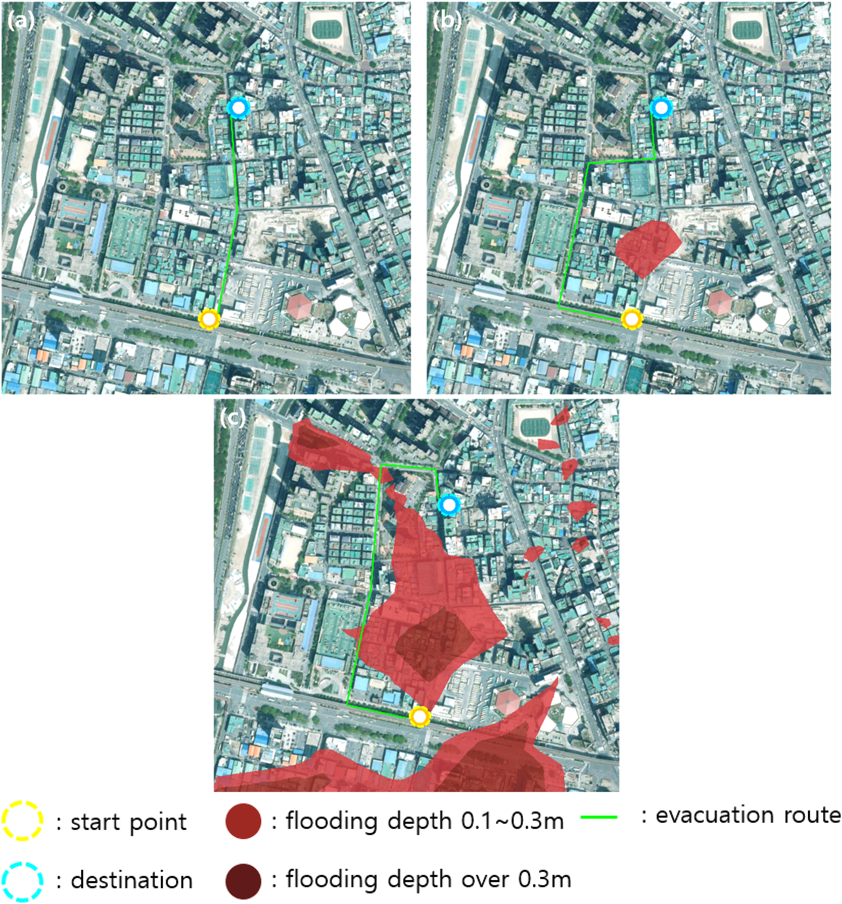
Our scenario assumes localized torrential rain with hourly precipitation of 105 mm leading to river inundation that is obtained using a localized heavy rain simulation. The range and depth of flooding of roads depend on the amount of precipitation, and vehicles can still drive on roads that are not completely flooded. Therefore, we calculate the route cost based on the risk to the roads by adjusting the value of r for flooding. The route cost is proportional to the time it takes for a vehicle to pass through the road. Therefore, the value of r is determined based on the speed of vehicles using the roads for each risk level. According to research,57,58 the optimal driving speed in heavy rain is about 15 km/h, falling to 10 km/h on a road with a flooding depth of 0.1–0.3 m. Thus, it can be assumed that the route cost of a shallowly flooded road is 1.5 times that of a general road. According to a policy briefing for Korea, 59 using a flooded road that exceeds two-thirds of the tire height (about 0.4 m) is dangerous. Based on this, r is set to 1 for normal roads (flooding depth lower than 0.1 m), 1.5 for low-risk roads (flooding depth of 0.1–0.3 m), and 10 or more for high-risk roads (flooding depth over 0.3 m).
In Figure 6, the point marked in yellow is the starting point, the point marked in light blue is the destination, the light red areas are shallowly flooded, the dark red areas are deeply flooded, and the green line is the evacuation route. Figure 6(a) shows the result for the conventional route search that cannot avoid the danger area, while Figure 6(b) presents the results for an approach that completely avoids the shallowly and deeply flooded areas by assigning a large value of r regardless of the flooding depth. Figure 6(c) shows the path with the lowest total path cost when the value of r is applied differently depending on the depth of the flooding. The cost of the evacuation route in Figure 6(c) is about 5% lower than that in Figure 6(b). Our method searches for an optimal evacuation route by considering the disaster risk and the total route cost. With our proposed approach, we reduce the damage caused by disasters by ensuring that the evacuation times are not prolonged while still ensuring the safety of the evacuees.

Evacuation routes in a flood using (a) a conventional route-searching method, (b) an approach that completely avoids disaster risk, and (c) a method that avoids disaster risk considering the disaster characteristics and risk levels.
The proposed algorithm searches for appropriate evacuation paths according to changes in disaster risk. Figure 7 shows the evacuation path according to the change in the flood risk area according to precipitation in an area. For 50 mm of heavy rain per hour, there are no flood areas, so the algorithm finds the shortest route between the start point and destination. In Figure 7(b) and Figure 7(c), our method avoids disaster areas while considering the total evacuation cost As a result, our algorithm works well with varying disaster risks.
Evacuation routes with varying of disaster risk area: (a) heavy rain with 50 mm/h, (b) heavy rain with 105 mm/h, and (c) heavy rain with 150 mm/h.
Analysis for case studies
This section discusses the qualitative evaluation for case studies of whether the proposed framework is appropriate for disaster response management. We construct a road network with a multilayered structure to respond to disasters. The road network has advantages in terms of disaster response and information management. As shown in Figure 4 and Figure 6, our method searches for a route that avoids roads with a disaster risk using the GIS-based connection between the road network layer and the disaster layer. In addition, we can explore multiple evacuation paths that route evacuees by considering the number of evacuees and the capacity of the surrounding shelters using the safety zone layer as presented in Figure 5. Each layer stores information on the roads, disasters, and shelters in parallel so that, if there is a change in a certain component, the overall network structure does not need to be modified. For example, in our flood damage case study, only river flooding is considered, but not flooded areas due to localized effects due to poor drainage. If flood traces for both river and inland flooding are considered, we can reflect this in the disaster layer and establish an evacuation plan without reorganizing the entire network structure. Therefore, the multilayered road network representation is appropriate for disaster response management.
In our method, it is possible to respond to various disasters by storing disaster-specific zones in the disaster information layer and disaster-specific shelter information in the safety zone layer. In addition, the proposed method searches for different evacuation routes according to the risk levels associated with an individual disaster. Figure 6(c) shows the results for a route search that considers the risk of flooding and the cost of the entire route, while the method applied in Figure 6(b) avoids all flooded areas to ensure route safety but evacuation time is longer because the overall route cost is high, which is a disadvantage. Our method thus reflects the characteristics of individual disasters to reduce the risk while balancing the cost of the entire route to find the optimal route.
Discussion
In this paper, the road networks are consisting of road information and the disaster risk areas from public data. The multilayered structure of the road network stores various types of information about roads. With graph structures, we manage components of the network through the connection of nodes in each layer. The proposed framework not only avoids disaster risk but also reduces traffic congestion by directing the movement of evacuation personnel. Our evacuation route algorithm reduces the load on the roads by providing routes to multiple shelters, preventing all evacuation personnel from moving through one specific route. The algorithm also ensures that the number of evacuees does not exceed the capacity of any one shelter, thus preventing a shortage of materials or space at the shelters. As a result, our framework avoids disaster risk areas to prevent direct damage from natural hazards and reduces social disaster damage by reducing traffic jams and congestion in shelters.
On the other hand, our model evaluates the evacuation routes focusing on the evacuation time based on the length of the road. It means that there is a lack of considering transportation engineering issues and the capacity of roads. Our method has information on the width of the road, so we can estimate the capacity of each road based on road width, but it is difficult to identify the congestion of the overall network.
Conclusion
This paper explores complex disaster responses that prevent chain reactions between natural hazards and social disasters by providing safe evacuation routes. We designed a multilayered structure for a road network that was suitable for disaster response management, employed a route-planning approach that considers the risk factors and risk levels for each disaster, and proposed a disaster response framework based on the research results. The proposed method is designed to prevent secondary accidents that may occur during the evacuation by providing safe evacuation routes during a disaster based on a multilayered road network that includes the information necessary for disaster evacuation. As a result, we reduced the city's disaster vulnerability by making it difficult for natural hazards to expand into complex disasters through effective evacuation route planning. In future work, we need to reduce the damage caused by traffic congestion by providing various routes that consider additional factors such as road traffic.
Footnotes
Declaration of conflicting interests
The author(s) declared no potential conflicts of interest with respect to the research, authorship, and/or publication of this article.
Funding
The author(s) disclosed receipt of the following financial support for the research, authorship, and/or publication of this article: This work was supported in part by the National Research Council of Science & Technology (NST) grant by the Korean government (MSIT) (1711101951) and in part by Korea Institute for Advancement of Technology (KIAT) grant funded by the Korea Government (MOTIE) (P0012724, The Competency Development Program for Industry Specialist) and part by the Chung-Ang University Research Scholarship Grants in 2022.
Author biographies
Taeyoung Choe is master's student in the Department of Computer Science and Engineering at Chung-Ang University. His research interests include Data Mining, Data Analysis, Graph Embedding.
Jiho Kim is a is currently a researcher at in the Disaster Prevention Research Division at National Disaster Management Research Institute (NDMI). He received the MS degrees from the school of Computer Science and Engineering at ChungAng University, Seoul, Korea in 2022. His research interests include disaster evacuation, urban resilience, and network analysis.
Mincheol Shin is a PhD student in the Department of Computer Science and Engineering at Chung-Ang University. He received the MS degrees from the Department of Computer Science and Engineering at ChungAng University, Seoul, Korea in 2021 and BS, degree in computer engineering from Wonkwang University, Korea, in 2019. His research interests include Data Mining, Data Analysis, High Performance Computing, Graph Embedding.
Kwangyoung Kim is a researcher at Dept. of Data Solution in Convergence Research Center for Data Driven Solution at Korea Institute of Science and Technology Information (KISTI). His research interests include Data Mining, Information Retrieval and High Performance Computing.
Mucheol Kim is a faculty in the Department of Computer Science and Engineering at Chung-Ang University. He received the BS, MS, PhD degrees from the school of Computer Science and Engineering at ChungAng University, Seoul, Korea in 2005, 2007 and 2012, respectively. He was an assistant professor in the department of computer & software engineering at Wonkwang University (2017-2018). In 2014-2016, he was an assistant professor of Department of Media Software at Sungkyul University, Korea. In 2011-2014, he had been working as a senior researcher in Korea Institute of Science and Technology Information (KISTI), Daejeon, Korea. His research interests include Data Mining, Information Retrieval, Web Technology, Social Networks and High Performance Computing.