
Abstract
We are living climate change. The unchecked acceleration of globalisation, colonisation, and extractivism create a world in dire need of change if we are to survive. Crucial now, are critical, geopolitical, and biopolitical discussion and an urgent need for diverse methodologic and pedagogic strategies for action across micro to macro scales. Research-creation, practice-led approaches to action, that work across and with artistic practice, scientific data, and critical and cultural theory can spark activist pedagogic experiences for change. The effective potential of such methodologies is explored via inefficient mapping; a counter-mapping, methodologic protocol, and its use in ‘Mapping Extinction’, a project into the catastrophic biodiversity loss due to the 2019/2020 Australian bushfires. The protocols and visual works produced facilitate discussion on creative practice as educational research into the real impacts of climate change.
Keywords
Introduction
We are living with climate change. Weather records are being broken at an ever-increasing pace worldwide: heatwaves in Russia and Canada, floods in the Netherlands, UK, and Germany, and snowstorms in Spain. 1 The harrowing images in the press of entire coastlines submerged by rising water levels and emaciated animals dying from drought are just small snapshots of the scale of the damage. The unchecked acceleration of the culprits: globalisation, colonisation, and extractivism has resulted in a world in dire need of change if we are to survive. Crucial now are critical, geopolitical, and biopolitical discussions of the damages caused by global capitalism and an urgent need for diverse methodologic and pedagogic strategies for action across micro to macro scales.
The Special Issue focus on the role of educational research in responding to the climate change emergency and climate injustice conditions, prompts the question: What can academic research do at a time like this? And, more importantly, what can it do for a time like this? How can educational ‘researching’ offer practical, productive actions for critical engagement and change, and how can the resulting productions of these actions initiate interceptions and interruptions to climate change progressions?
My paper advocates for the importance of practice-led approaches to action. Trans-oriented, transboundary projects that work across and with artistic practice, scientific data, and critical and cultural theory can spark activist pedagogic experiences for change. Specifically, I discuss how inefficient mapping, a counter-mapping, methodologic protocol, and the project ‘Mapping Extinction’ addresses catastrophic biodiversity loss due to the 2019/2020 Australian bushfires. Mapping extinction in this context refers to sourcing data on the native wildlife and botanic life critically impacted by the bushfires and creating visual works that feature their selection as an alternative form of charting threatened species. I have written extensively on inefficient mapping (Duhn et al., 2021; Hickey-Moody et al., 2021; Knight, 2016, 2019a, 2019b, 2020, 2021; Koro-Ljungberg and Knight, 2019) and its use as a methodological protocol for attuning to events and occasions in the world when the world is thought about through post- and speculative theories. ‘Protocol’ refers to a common practice within creative arts whereby strict operational mapping rules that control the practice conditions conversely spark expansive and creative responses (O'Rourke, 2013). The expansiveness shifts the focus from attending to the method to being immersed in the situation and closely and acutely recording that. Inefficient mapping uses embodied, visual, and sonic modalities to capture nuanced meanings. This is particularly useful for communicating the “‘marginal imaginaries’” (Kinkaid 2019: 252) of non-dominant voices, lives and experiences. While I have written elsewhere on the potential of inefficient mapping to shift away from the schematic fixity of Western maps and instead attend to speculation and interrelational movements, in this paper, I focus more on the practice-led aspect of the approach. Through a selection of some of the works from the Mapping Extinction project, I explain the different drawing practices used. In doing this, I advocate for practice-led critical educational research methodologies that generate holistic understandings and conceptualisations of reciprocity and responsibility. Through the example of the Mapping Extinction project, I propose that inefficient mapping is processually, onto-epistemologically, and ethically capable of producing ecological and environmental education research.
This paper focuses on the potential of speculative research-creation methodologies, specifically inefficient mapping for doing environmental education research into a global environmental issue via a particular national context. Examples of the research-creation works produced during the project and their descriptions detail how speculative methodologies, i.e., methodologies that purposefully research what might be coming next rather than investigating and reporting on what is evidenced now, accommodate the rich complexities of climate change research, including the constantly emergent changes that occur and the respective continuous uncertainties these changes provoke.
Mapping Extinction is educational research through a critical examination of the impacts of colonisation on the more-than-human, i.e., how the ways of living, implemented and since perpetuated by colonial settlers, have had a significant impact on Australian ecology and geology. Impacts include the direct actions of hunting, clearing habitats, industrialisation and extraction practices on Australian native wildlife, and the indirect effects on biodiversity. The conscientious decision to undertake a research project on this targeted focus facilitated more significant learning about the ongoing impacts of colonisation on more-than-human climate injustice in Australia. As a white, non-invited settler in Australia, the project enabled me to commit to decolonial practices and investigations into climate change.
Research-creation, practice-led approaches to educational research
Methods such as research-creation that combine different scholarly practices facilitate transdisciplinary investigation (Loveless, 2019) of complex ideas. Proponents of research-creation, including Manning (2016), Ostashewski et al. (2020), Springgay and Truman (2019), and Truman (2021), embrace research-creation methods for investigating the non-representational aspects of the world. In their edited volume of non-representational theory and the creative arts, Boyd and Edwardes (2019) describe the non-representational as an approach to thinking about the messiness of life because “there is more to the world than we can consciously know or represent” (p. 3). Rather than a reliance on the reductive and schematic, non-representation is instead a practice immersed and co-relating to the ongoing experience of life as it takes place. Tuning in to the affects, sensations, and materiality of the world and exploring the inductive nature of speculation. Working simultaneously and methodologically across practices, including making, prototyping, reading, reflecting, evaluating, and creating, non-representational research-creation are experimental methodological approaches for examining climate change sequences and movements as they unfold. In Mapping Extinction, non-representational research-creation is a practice for examining, simultaneously across different scales, the changing nature of Australian ecologies as they continue to change after significant bushfires.
Inefficient mapping
The Mapping Extinction project was not linear; drawing experimentation took place alongside linguistics research into Aboriginal languages, ecological research into biodiversity data, internet-based investigation into social media video footage, theoretical reading into mapping, art in the Anthropocene, speculative theories, visits to galleries, and more. This collection of activities did not gradually move forward sequentially but continued to gather and disperse in different intensities throughout the project. The project is still being concluded, and more work is being produced as the theories, practices, and contexts evolve.
A practice-led approach disrupted the privileging of dominant earth sciences knowledge through a deep and careful investigation into the non-representational impacts of bushfires as markers of climate change through practices and theories that co-inform ideas on ecological injustice. Educationally, a research-creation approach generates an entirely different examination and understanding of environmental damage.
Mapping extinction
Towards the end of 2019, Australia experienced a huge and dangerous bushfire season. Thanks to colonial mismanagement of the land (Pascoe, 2018; Smith et al., 2021) and its unique ecologies, bushfires have unfortunately become a regular event of the Australian calendar (Bowman et al., 2022). There is reporting that the occurrence and ferocity of these bushfires have increased in recent years 2 with Australia’s Commonwealth Scientific Industrial Research Organisation - CSIRO reporting that the Forest Fire Danger Index, the measurement tool that shows the fire danger level on a given day, was its highest in 2019. 3 The bushfires raged across the east coast of Australia from November 2019. The coverage, which affected Queensland, New South Wales, Australian Capital Territory, and Victoria, 4 eventually destroyed an estimated 33.8 million hectares of forest (Binskin et al., 2020), destroyed over 2700 homes (Tiernan and O'Mallon, 2020), caused over 30 human deaths (Henriques-Gomes, 2020) and killed over three billion animals and insects (Slezak, 2020). The impact on flora and fauna was and continues to be disastrous, with many species driven to or near extinction.
As news items showed the most horrific scenes of the fires, raging in almost unimaginable scale down the eastern states, news reports also began to emerge of the equally appalling stories of catastrophic loss of Australian biodiversity: not only the decimation of forests and plants, but of animals, insects, birds, and reptiles. This was disastrous because of the sheer scale of the numbers and because many of these animals are already at risk or endangered. Australian wildlife face challenges for many reasons: becoming the prey of introduced species such as cane toads, foxes, rabbits, and feral cats, domestic dogs; loss of habitat due to land clearance; and severe weather events such as floods, fires, and droughts. All these challenges are connected to the impacts of colonisation, capitalism, and extractivism.
Initial responses to disasters of this scale are visceral and driven by affect. As the Australian bushfires raged, many public members gave money, vast sums of it, in hardly any time. Most famously, this included the incredible AU$51 million Australian comedian Celeste Barber raised through social media for firefighters. 5 Many also rushed to donate clothes and supplies to affected families, and others worked around the clock, sewing pouches and slings for badly burned animals. 6
These immediate, affective reactions are entirely understandable. Reactive gestures have a short lifespan, however. While practically useful (and often vital), educational research is needed to initiate sustained intellectual and creative activism that is considered rather than frantic, critical rather than reactive, and creates change than being an emergency response. Educational research can attend to specific aspects or a broader scope of factors, examining the complexities of the event and investigating relationships between components of the problem. Notably, the social collectivism deeply embedded in educational research drives the agenda to explore, test, create, and promote ongoing strategies, dialogues, and responses to climate change and its increasing impacts. This was the intention of Mapping Extinction; to exemplify how a counter-cartographic practice undertakes educational research that simultaneously puts to work theories, techniques, processes, and information to disseminate on the impacts of the bushfires. The project offers a practice for investigating diverse information sources and counter-mapping these in ‘inefficient’ ways (Knight, 2021). Inefficient mapping is purposefully partial and anti-schematic, so the inefficient here refers to both the details included and the spaces and how these spaces hold the excesses of the situation, the facets and details that transcend representation but are nevertheless present as energy within the marks and the voids.
The primary driver for Mapping Extinction was to research a particular aspect of the bushfires and create a body of work contributing to contemporary commentary on climate change and its relationship to colonialism and capitalism. My focus on biodiversity loss used data recorded in the International Union for Conservation of Nature (IUCN) Red List of Threatened Species, 7 as well as news reports occurring during the fires. These sources helped compile a list of wildlife deeply impacted by the fires. The list was randomly chosen and included birds, reptiles, insects, and mammals. Each example became the topic of a work that visualised the research undertaken via drawing and inefficient mapping. More detailed descriptions of their production are provided below and are accompanied by examples from the collection. The examples are discussed via facets of my working process. However, it is important to understand that all the works in the collection were created via the complete methodological protocols. The sub-headed topics are provided to assist the reader in learning more about the details of the project and the approach taken. The reflective descriptions under the sub-headings do not attempt to speak to disciplinary expertise; instead, they convey how knowledge, practices, and theories became entangled within specific concentrations as important aspects of the project. Collectively, they and the examples from the Mapping Extinction project demonstrate how research-creation approaches such as inefficient mapping have methodological strength and flexibility to generate critical educational research on highly complex, complicated issues.
The series of protocols established for Mapping Extinction included: creating specimen drawings of threatened/extinct animals using a single blue colour pencil; sourcing the common English name as well as the name given in the language group local to the affected area; and overlaying the drawing with inefficient mappings of the animal's movement, sourced from publicly available video footage. A more detailed discussion of each of these protocols is now provided, and an image from the collection of works accompanies each.
Project protocols
The scientific specimen
Drawing the animals as a scientific specimens helped the works to address the politics of the conditions for extinction. And specifically, the impacts of colonisation that generate those politics. I thought about the concept of ‘the time before’ before Australia became a British colonial outpost before the land and its ecologies, its people, and its cultures were changed and impacted by the arrival and occupation of my forebears (Figure 1). Botany Bay diamond weevil/narron (Wathawurrung). 2020. Pencil on paper.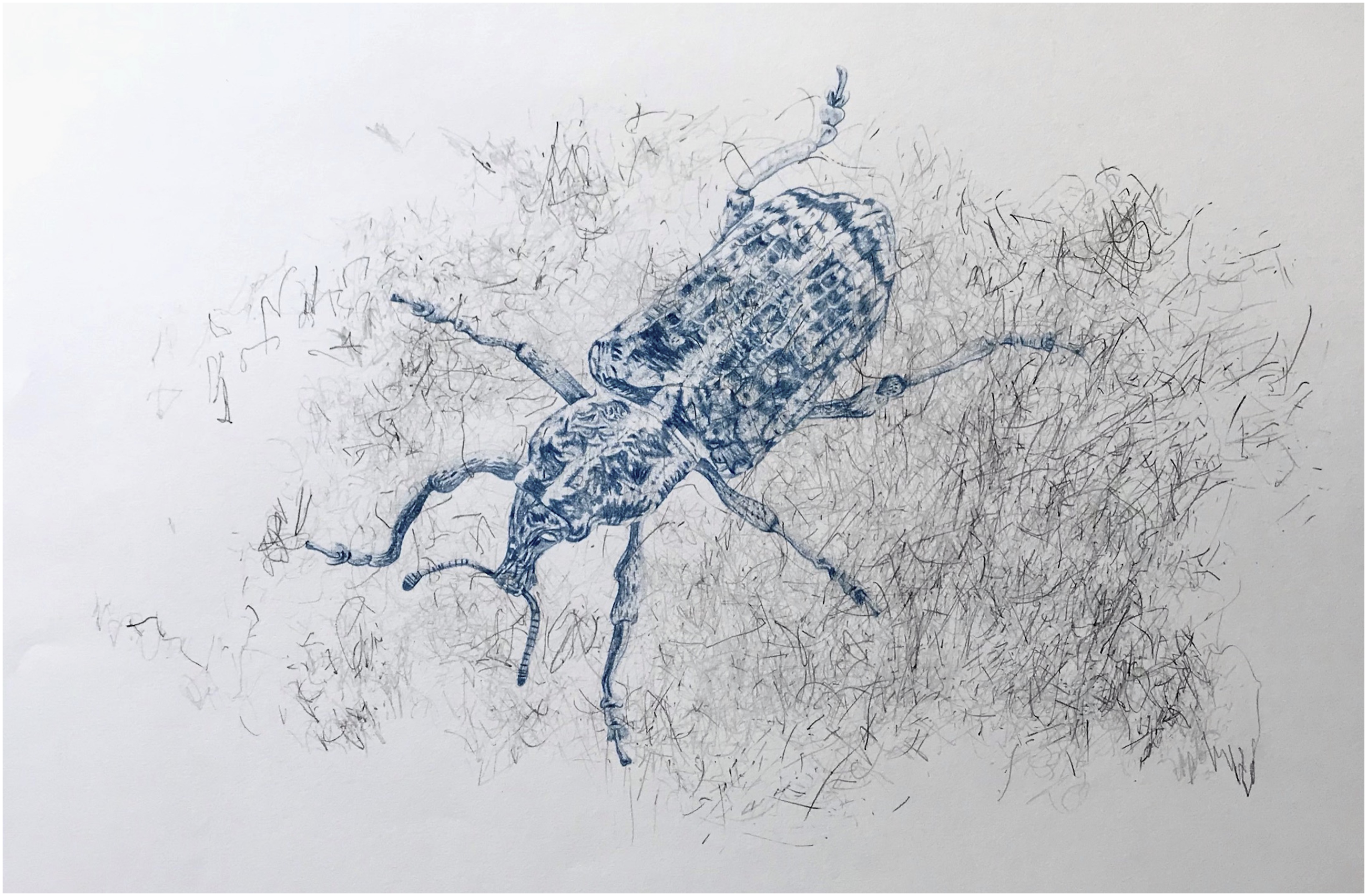
The blue drawings reference the style of early traditions of making scientific illustrations of specimens such as shells, birds, insects, flowers, animals, and plants. Scientific illustrations were often produced by botanists and scientists onboard voyaging ships: in the Australian context, many scientific illustrations were produced by Sir Joseph Banks, who accompanied Captain James Cook on the HMS Endeavour on the voyage around the Asia Pacific and that brought them to Australia in 1770 (Banks, 2017). Scientific illustrations regard the specimens with dispassionate curiosity, inspected for their potential to advance (Western) scientific knowledge. While some illustrations have minimal contextual information, such as a patch of ground or section of a branch, most are decontextualised with the specimen placed onto a deliberately plain uncoloured background, allowing for details such as genus groupings, markings, size, habitat to be foregrounded.
The early example illustrations are also often highly stylised and can be quite inaccurate because the creators had varying artistic drawing skills and were experiencing flora and fauna for the first time. Typically, small brief sketches would be made in situ with the illustrations refined from memory at some later point, making for the creative licence being used in many instances.
It was laborious to create the drawings. Images of each creature were sourced from online repositories and printed out in colour on low-grade copy paper by my home printer. This was a deliberate move to work speculatively, imagining a future when native Australian animals are extinct and only online photographs remain. This process also replicated the inaccuracies created by working not from actual life but from a facsimile, forcing me to guess about some details. I drew as accurately as possible, using a magnifier with powerful lighting and extremely sharp pencils that needed constant sharpening. Initially, I got migraines from looking through the bevelled lens, but over time my eyes adjusted, and I could draw for long periods. These attentions to detail were my performative commitment to the reparative practice in the project: to pay intense attention to these very humble and tiny creatures whose lives were devastated by the bushfires.
Drawing in the style of scientific illustrations created by colonial westerners connects to the semiotics of scientific illustrations in that the practices of contextual removal and dispassionate objectification minimised potentials for affective connection, and this disconnect allowed for ecological destruction in the pursuit of resource extraction. The ongoing impacts of deforestation, land clearing and introduced pests became brutally apparent in the 2019/2020 Australian bushfires.
The blueprint
The collection of works for Mapping Extinction feature flora and fauna drawn in different shades of blue. Each work uses only one pencil, hence a single shade of blue (Figure 2). This protocol works with the visual pun: the drawings are literally and symbolically a ‘blueprint’ of a non-human body impacted by climate change and offer a comment on ecological precarity. Connecting to the conceptual reasons for mimicking scientific illustrations, there is a dispassionate objectification in drawing a creature on the brink of, or extinct in the style of a drafting plan - a blueprint. Drawing the animals as blueprints is a durational reading of climate change. During these extreme events, we face the timescales of colonial occupation, extractivist wealth creation, and environmental change. Extinct: Mount Glorious torrent frog/worba (Wakka Wakka & Gubbi Gubbi). 2022. Pencil on paper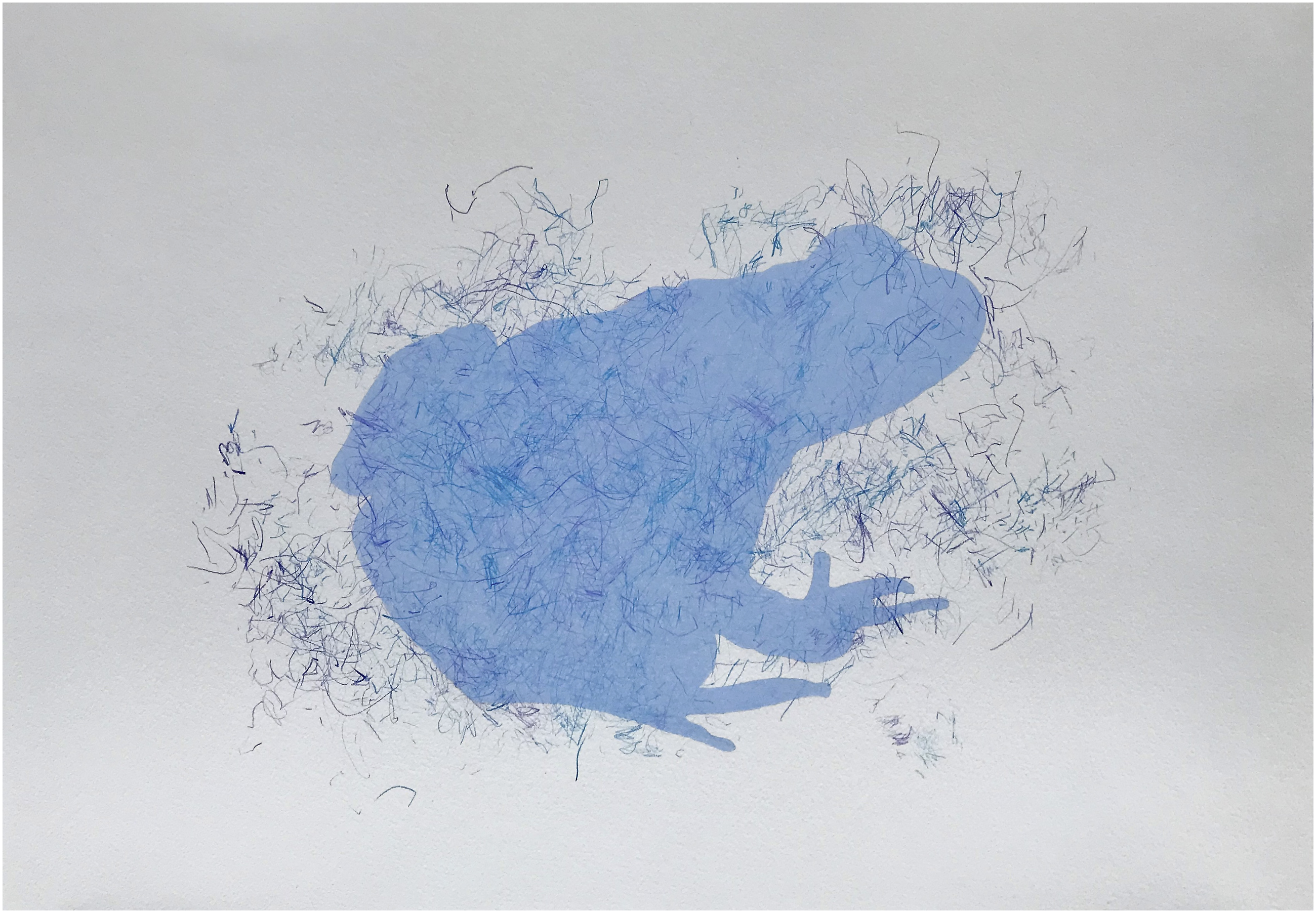
Mapping movement
Juxtaposing the stilted, objectifying blue drawings of each creature are highly animated, inefficient mappings of its bodily movement observed in short videos of the creature posted on the web. I undertook searches of each creature and created folders of the videos I found. The videos vary in professionalism and quality, and many are short. I watched the same small number of videos repeatedly and inefficiently mapped the movements onto the top of the blue drawing while I watched them. I do not look at the drawn mapping marks being made, but in the video, this is important to attend to the animal’s movements and gestures (Figure 3). Mapping extinction. 2021. Pencil on paper.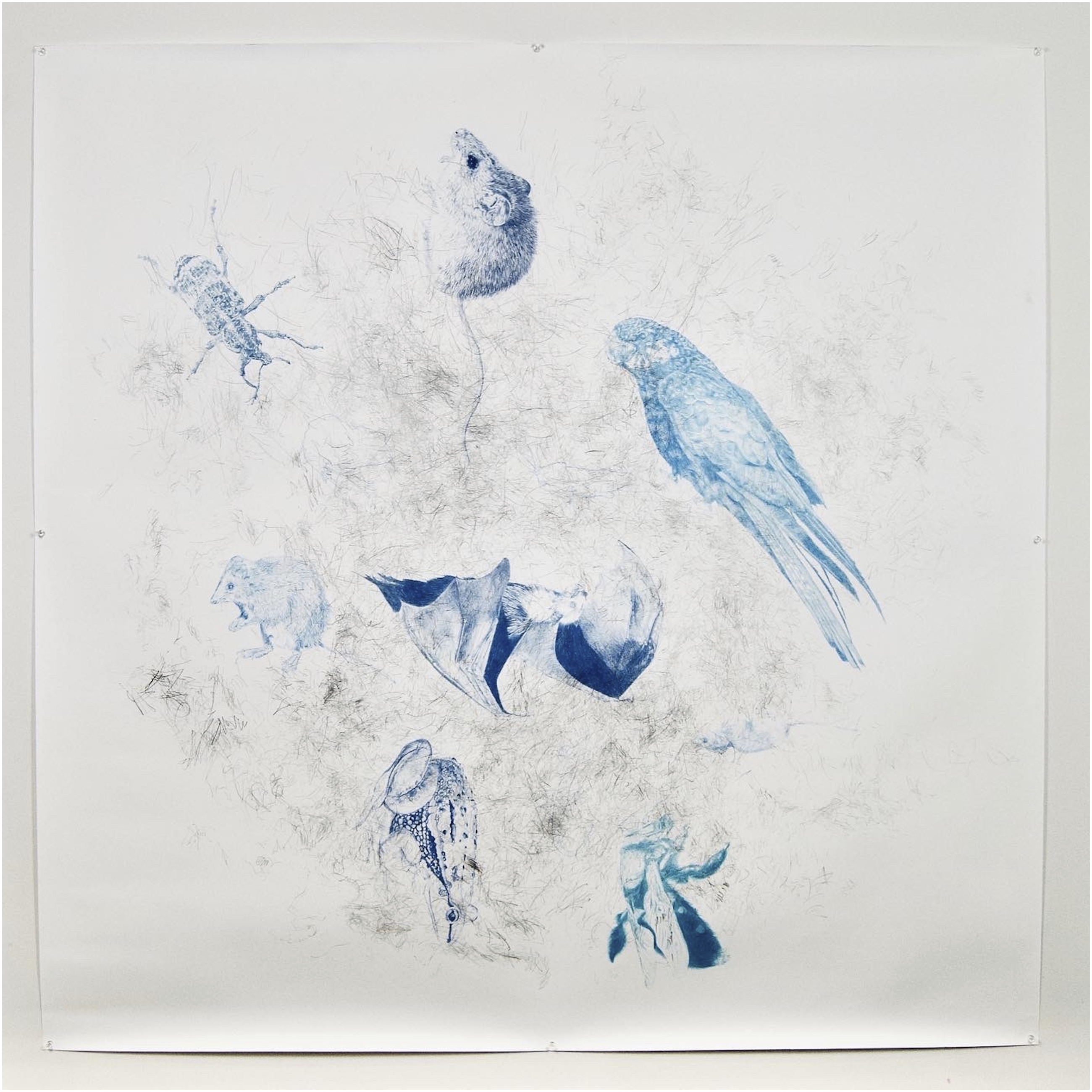
Inefficient mappings traced the directions and speeds of the creature's multiple movements with the different parts of its body and within a scape. The tracings were created using clusters of hard graphite pencils. Usually, six were held loosely in each hand. As the sequence of videos played, my eyes darted across the frames, and I attempted to convey these onto the paper with both hands working at once. I have done enough inefficient mapping that I am now able to simultaneously trace more than one ‘set’ of movements, such as the gross motor movements of a potoroo’s body as well as the fine motor movements of its jaw crunching. As the videos scrolled past, my right hand would trace some movements, and at the same time, my left hand would trace others.
In extreme contrast to the careful detail of the specimen drawing, the inefficient mapping marks are highly gestural and made without looking at the paper. However, there is an irony in this because the videos are no more a reality than the printed photographs used for the specimen drawings. Using recorded videos instead of observing live animals was a purposeful decision to performatively speculate on future modes of ‘live’ access to wildlife in unstable and uncertain climate times.
Naming/labelling
Of all the protocols I followed, the naming and labelling of each work most clearly exemplify the educational practice-led approach because labelling connects the project's different co-developing and co-informing experimental and theoretical practices. Information repositories I accessed for the project on biodiversity loss due to bushfires, whether a news report, scientific report, Web site, database, an image bank or video bank, almost exclusively described the creatures via their common English name or their Latin scientific name. While some repositories were international, many were Australian sources and focused on Australian biodiversity. The scientific practice of using common English and Latin scientific names privileges particular languages and the knowledge systems they belong to. Their use thus exclusion of Indigenous language names and the scientific, ecological knowledge systems about creatures studied by Aboriginal and Torres Strait Islander peoples for tens of thousands of years (Figure 4). Long-footed potoroo/winnenerbee (Gunai). 2020. Pencil on paper.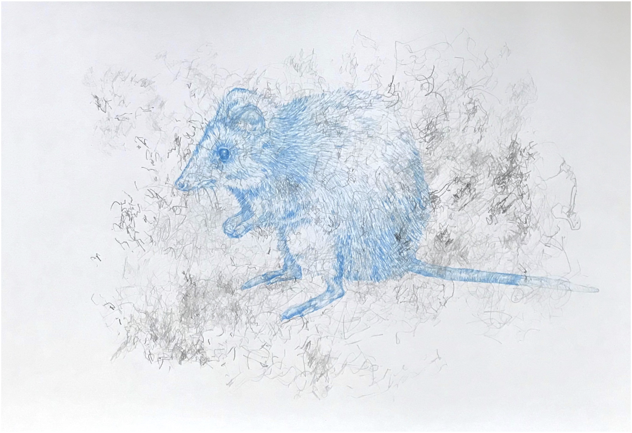
I undertook linguistic research for each creature selected. Once each drawing and mapping was completed, I used the locational information I had for the animal to research the language groups and culture groups 8 local to the fire-affected area. I sourced different linguistic records ranging from community-produced dictionaries by local communities, such as the Australian Society for Indigenous Languages (AuSIL, 2022), to historical accounts compiled by early European colonists (Blake, 2011). Each of the works in Mapping Extinction contains the common English name, Aboriginal language name, and relevant culture/language group.
The naming and labelling practice in Mapping Extinction was a research-creation investigative process of drawing, mapping, and linguistic education that attended to the non-representational aspects of colonial impacts on ecologies. These collective actions extend on the images as mere representations of Australian wildlife, making them instead a series of counter-maps of climate change.
Timescales
Each work within Mapping Extinction utilises references and sources from different periods that are visualised via the layering of blue drawings, mapping marks, and labelling (Figure 5). Drawing upon a range of historical documentation is a common feature of research and nothing unusual; however, in Mapping Extinction, the pulling of records and recordings from across timescales into a series of visual drawings becomes pertinent in a project that speculatively explores issues of climate-related extinction. The timeline across the combination of historical and contemporary linguistic resources, the more recent video, photograph, and news archives, and the constantly updating Red List is a resource with ecological richness and diversity. This scope facilitates counter-mapping across past and future times, each having cultural and environmental interrelationalities with colonial extractivism and land development on native flora and fauna and, more widely, on cultural sites. Southern brown bandicoot/wydung (Jarwadjali). 2021. Ink and pencil on paper.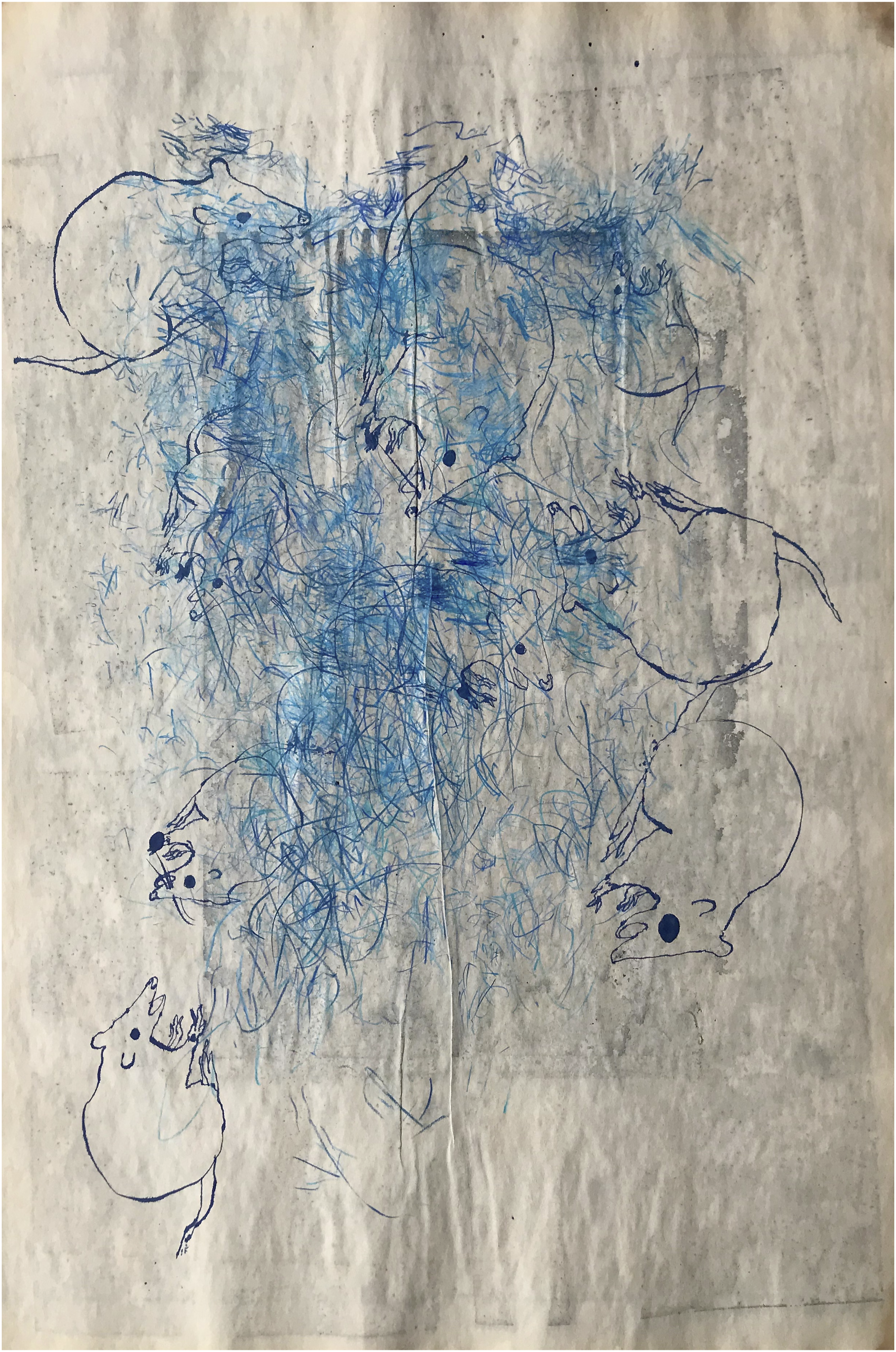
Voids and excesses
The scientific specimen protocol and the mapping movement protocol conveyed information via pictorial and abstracted drawing; however, the two distinct approaches each presented details and left absences. The specimen drawings may ‘look like’ something, but they have no context; there is no clue as to where the creature is, no extra information that gives it a life beyond its natural form. The movement mappings are abstract marks that convey only part of the complete range of movements the creature displayed in the video segment (Figure 6). The naming and labelling, too, leave space in terms of broader information about the culture/language group and the non-representational spaces between the two languages in each label. Gum leaf grasshopper/gilwill (Wiradjuri). 2021. Pencil on paper.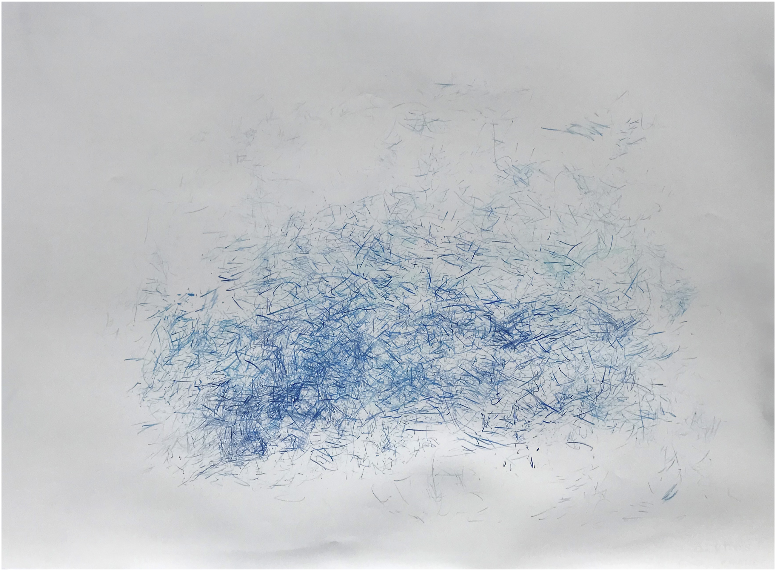
The unmarked aspects are not voids, however. Rather, they pay attention to the excesses of climate change research dissemination, government policy, news reporting, and education. Such quantities are the hard-to-prove-but-continuing impacts of extractivist, profit-driven approaches to the environment from mining, agribusiness, land clearing, and urban zoning practices, which were broadly not referred to as mitigating factors during the reporting of the 2019/2020 Australian bushfires. The unarticulated excesses were a deliberate counter-mapping strategy to map ecological crisis in non-representational ways by purposefully thwarting easy reading of the collection in contrast to the deliberately reductive schematics in conventional maps primarily designed to orient the wayfaring stranger across the land.
Discussion
Mapping Extinction is a creative practice for educational research into the impacts of climate change on biodiversity loss. The inefficient mapping examples from the project explore the excessive effects of climate change on unwitting victims, and exemplify how the processes of drawing within inefficient mapping facilitate data that is non-representational in that they attend to the excessive and difficult-to-describe conditions of ecological catastrophe and speculative in that the images are visualising possible future scenarios. The creatures in the collection might be tiny individuals; however, the extensive activity and research needed to create each drawing mean that each piece comments on the impending global disaster of catastrophic biodiversity loss that might occur in the future. Methodologically, the Mapping Extinction project continuously brought together practices, theories, and concepts as one work was completed and another began. This continuity prevented the project from moving through progressive stages; instead, ideas, information, and productions continued throughout, critically examining climate change concerning the themes of the Special Issue: human supremacy, colonialism, capitalism, industrialisation, and white supremacy, among others.
As a methodological protocol, inefficient mapping complements other forms of research, especially ethnographic and creative practice approaches, because these, too, are less interested in distilling and summarising than attending and attuning to life in the moment, seeking out the details which might be disregarded in more systematic and deconstructivist analyses. The open-ended approach of inefficient mapping mustn’t be assumed to be frivolous, as the Mapping Extinction project exemplifies, practice-led approaches can partner with ethnographic methods to engage in high-stakes educational, ecological research into the cultural politics of environmental sustainability in uncertain times.
Footnotes
Declaration of conflicting interests
The author(s) declared no potential conflicts of interest with respect to the research, authorship, and/or publication of this article.
Funding
The author(s) received no financial support for the research, authorship, and/or publication of this article.