
Abstract
The mobility turn offers a rich terrain for research to investigate the exercise of politics and power in movement through attention to associated meanings and practices. Despite this, the ontologies that can anchor this research within a historical imagination remains largely uncharted. Happily for us, coming from the opposite direction history, and especially the field of transport history, has grappled with mobilizing history in the face of the mobility turn. Several scholars have offered “usable past” as a mode of mobilizing mobility cultures of the past to inform policy actors about future choices. But is the ontology of a usable past appropriate for countries enmeshed within pre/post/colonial histories of displacement in their society and culture? Employing a case of automobilization in the city of Bengaluru in India, this paper sketches an exposition of the “displaced past” in sedimented residues that continues to live and contest the enterprise of automobility.
Mobility as history
The “mobility turn” signposts an important point of inflection in the current lives of several traditional social science fields such as sociology, geography, and anthropology but also in other interdisciplinary fields of environmental studies, urban studies and science and technology studies. A key facet of this turn is the shift away from a sedentary ontology towards a nomadic one that posits that mobility is not just about physical movement but is a defining attribute of our social and cultural existence. 1 Such an ontological shift has enormously expanded the reach of social research to investigate politics and power in the exercise of movement through the attention to meanings and practices associated with movement. This shift is particularly relevant in the current moment with the realisation that transport and mobility are key vectors that determine the environmental footprint that we, humans, leave on a planet burdened by anthropogenic global warming. 2 With the mobility turn and its attention to power and politics, it is now possible for researchers to inquire into why particular patterns of mobility persist and are so difficult to break out of. Whereas in the recent past, studies of automotive dependence was the exclusive domain of transport planners and policy experts who looked towards built form to change patterns of movement, with the mobility turn several interesting trajectories for research into automobilisation emerge. For one, it is now possible to locate the automobile within a wider cultural, spatial, technological, and political matrix. Second, and more importantly, it allows us to inquire into the constituents of a system of automobility – a system of transportation articulated around the automobile that “generates and reproduces a specific character of domination.” 3 The domination of automobility, as a range of technology, transport, urban, environmental and popular histories have demonstrated in exquisite detail, has been a formative (and contentious) influence in the West that has transformed streets, cities and even countries in its wake. 4
Given this vibrant historical record of automobile occupation in the West, how do researchers view the surging growth in automobiles across the world but especially in the populous mega-cities of the Global South? 5 How does one attend to an emerging drama of social and material choices but at the same time anchor a historical imagination to avoid the charge of chronocentrism that is often levelled against social research. 6 This preliminary and tentative article seeks to develop an ontology of how the past manifests itself in more recent events. One way of doing this, Cresswell suggests, is to attend to “constellations of mobility”; doing so would allow the researcher to chart out historical continuities. 7 However, despite such helpful suggestions, the historical ontologies that can guide mobilities research remains largely uncharted. Happily for us, coming from the opposite direction history, and especially the field of transport and technology history, has grappled with mobilizing history in the face of the mobility turn. 8 Indeed, inquiring into the vital import of theorizing a (new) ontology for transport history, Moraglio opines the need to characterise the field as a study of movements as history. 9 Seen in this light, movement is not just a functional entity but requires an appreciation of how it is deeply embroiled within social and cultural histories that inflect its meaning and appeal and its associated technologies and infrastructures. Such an ontology demands a wider sensibility regarding the choices made in the past and the choices to be made in the future to realise movement. The choices humans made (or need to make) are necessarily involuted through unanticipated connections across time. A conception of history that leaves behind the linear to espouse more complex, layered and cyclical notions maybe the need of the hour. 10 One thing though is becomingly abundantly clear. As Worster points out in his discussion on bicycles, there is no place for ahistorical technology fixes. 11 Building upon these reflective strands, several Western scholars have offered “usable past” as a mode of mobilizing mobility cultures of the past to inform policy and public about choices that were not taken or the inertia-producing effects of past choices. The proposal for a usable past (to which we shall return later in the article) is instructive, especially in Western contexts where questions of unlocking a mature automobility to realise sustainable urban mobility is a topic of great policy relevance. But is the ontology of a “usable past” appropriate for countries enmeshed within pre/post/colonial histories of rupture and displacement in their society and culture? In the colonial/postcolonial contexts of the Global South, linear conceptions of historiographies of movement with its origins in economic and business histories continue to be dominant. 12 However, of late, longue durée historiographies heeding the call for studies of movements as history, have sought to trace the complex constitution of infrastructures of mobility by drawing a mesh of cross-linkages connecting colonial pasts and the postcolonial present. 13 Southern countries where automobility is an ongoing process, mobilizing the past is not so much looking for resources in the past but instead is an exercise in understanding the effort enrolled in navigating a past of displacements arising from colonial and postcolonial interventions into society, place and environment. Here, a conceptualisation of movement as a manifestation of a lived history is particularly instructive. I attempt to explicate this in this article with the help of a case study, to which we shall turn next.
In the next section, we trace the development of an elevated road in the city of Bengaluru between 2005 and 2017 to demonstrate the historically-situated contingencies that have mushroomed through the process of implementation. We conclude the paper by elaborating on an ontology of displaced past that attend to mobility in postcolonial contexts.
Case of a messy automobilisation
Bengaluru is a large metropolitan city in south-central India with an estimated population of 14 million people relying upon more than 8 million motor vehicles in 2021. As the locus of India’s knowledge economy centred on information and biotechnology industries and business process outsourcing, the resulting demographic and economic shifts in Bengaluru have been one important facet in the prominence that personal transport use has acquired in the city in recent years. Personal automobilisation is indicated through not only the sheer volume of personal vehicles that drive on Bengaluru’s roads but also asserted through a visible transformation in the nature of streets in the city and the patterns of mobility one finds on them. 14 Streets in Bengaluru, similar to many parts of India, were places where a fluid regime of occupying and using them was the norm (Figure 1). Within this context, street space for multiple pedestrian, non-motorised, and motorised mobilities was negotiated in a dynamic fashion on the ground, often giving the perception of chaos. 15 Indeed, the disorderly Indian street and the inability of Indians to behave in a civilized fashion in public was a narrative that was commented upon by several colonial travel writers. 16 Arnold notes that such narratives were particularly powerful in justifying the innate racial superiority of Britishers and forming the basis for efforts of colonial state to educate and discipline the native. 17 Since the 2000s, one now finds a notable shift in streets being redesigned to serve predominantly as conduits to automobiles. A distinguishing feature of this shift is the attention given to eliminating friction in automobile flows. Thus, excess vehicular flow, busy intersections, multi-use streets, non-motorised transport, narrow conduits, or multiple intersections are some common settings for friction in vehicular flow. Within this context of changed perception of the street, re-design of transportation infrastructures to establish fly-overs, underpasses, “signal-free” corridors, elevated expressways are some ventures to decongest roads and to facilitate smooth flows of personal motorisation. 18 As part of this shift, streets are increasingly encrusted with a range of infrastructures such as elevated roads, overhead expressways, flyovers that reduce automotive congestion while promoting smooth and seamless automobile flows. Figure 2 is a picture of a recent transformation in a street wrought by an overhead expressway and kilometres of street-fencing that segregates and reserves road space for the exclusive use of automobiles.
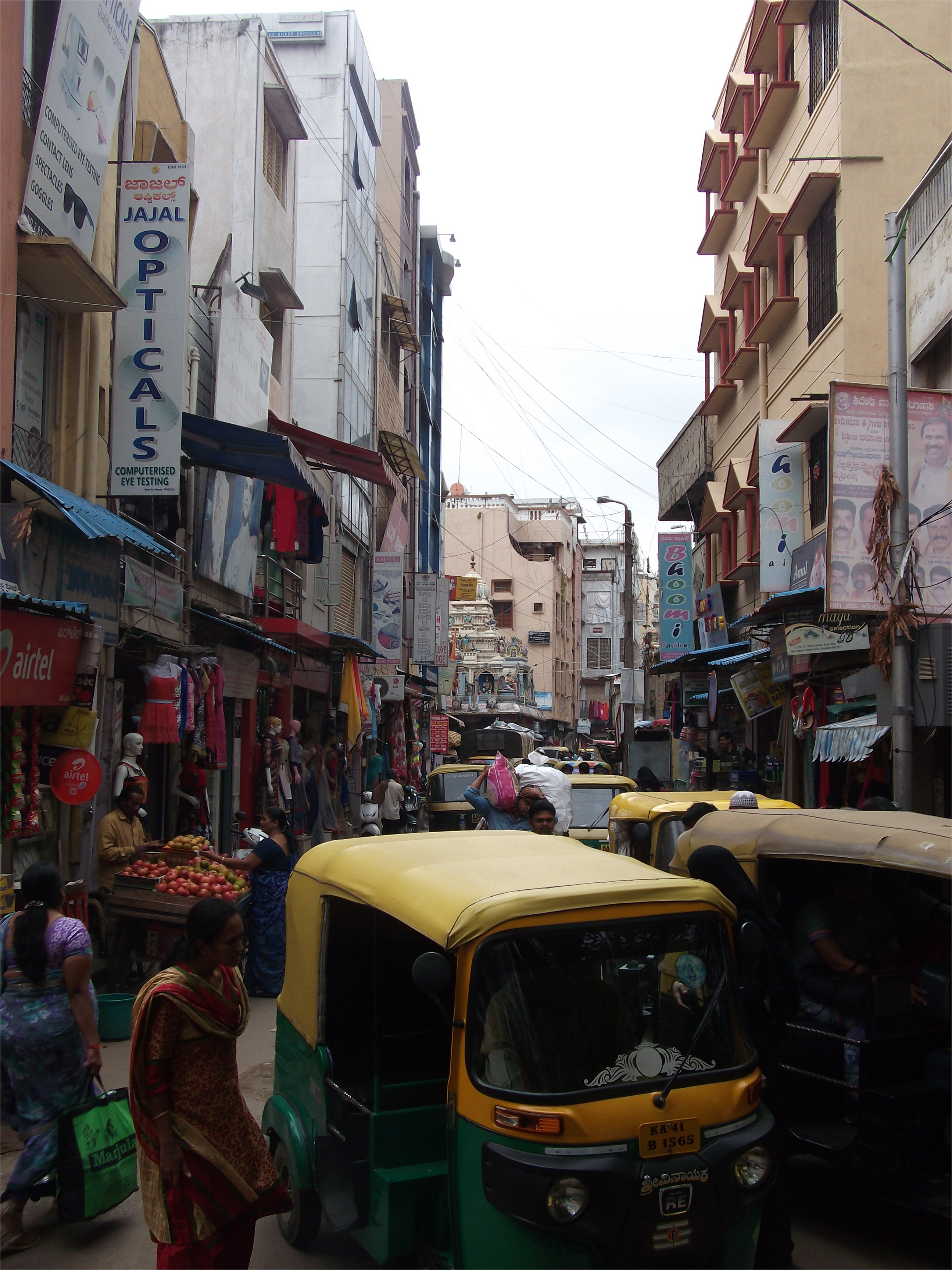
Roads with people and automobiles jostling for space (source: Govind Gopakumar).
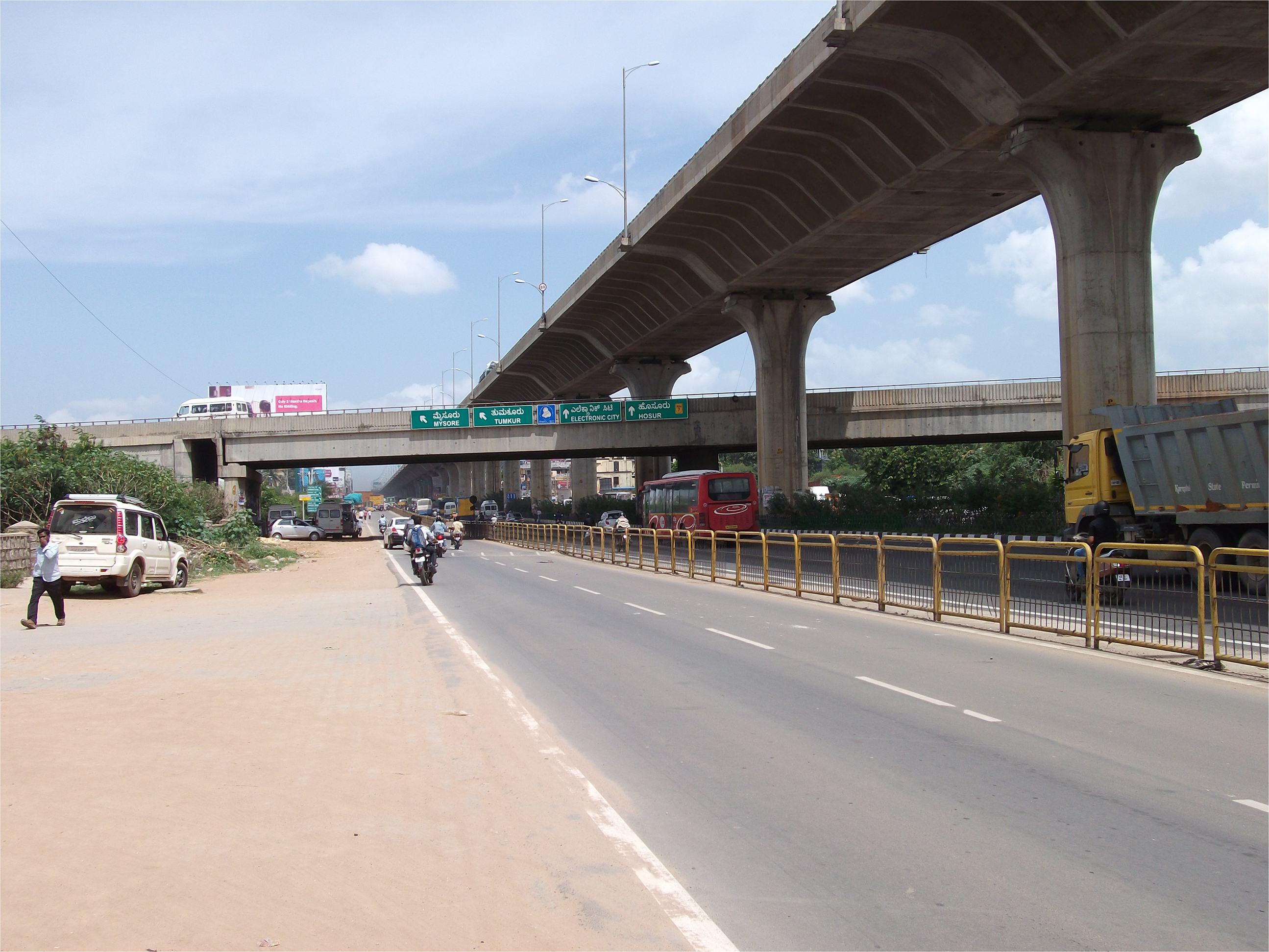
Overhead expressway stilts along the length of a road in Bengaluru (source: Govind Gopakumar).
However, the picture of a juggernaut-like automobility that utterly dominates the road in Indian streets is a misnomer. Efforts to reshape roads or create new roads often have to contend with deeply embedded histories of past interventions into governance, urban space and environment that can potentially derail or delay plans and designs. One example where the design imperative for friction-free automobile flows was embroiled with a historically embedded friction became visible in south-western Bengaluru in the project to construct an elevated road over the Vrishabhavathi River. Figure 3 shows the plan of the Vrishabhavathi River Elevated Road (VRER). This proposed road would connect two arterial roads – Chord Road and Mysore Road – and in the process divert flows at their intersection to create a “signal-free” intersection (shown as KIMCO junction in Figure 3). As can be seen from the arrows in Figure 3, according to the design plan, the VRER collected automobile flows through two “up-ramps” on Chord Road and distributed them at the other end through three “down-ramps” – one towards Bengaluru city, a second dedicated to buses towards the Mysore Road Bus Terminal, and a third towards Mysore. The key innovation of the VRER was that the main stem of the elevated road was placed over the channel of the Vrishabhavathi River for a distance of about 600 m. The primary design feature of the VRER was the creation of unidirectional automobile flow in Chord Road, Mysore Road and the elevated road. Each of these stems taken together locks-in a clockwise signal-free flow of automobiles thus eliminating the need for a traffic light to regulate automobile cross-flows at KIMCO junction.
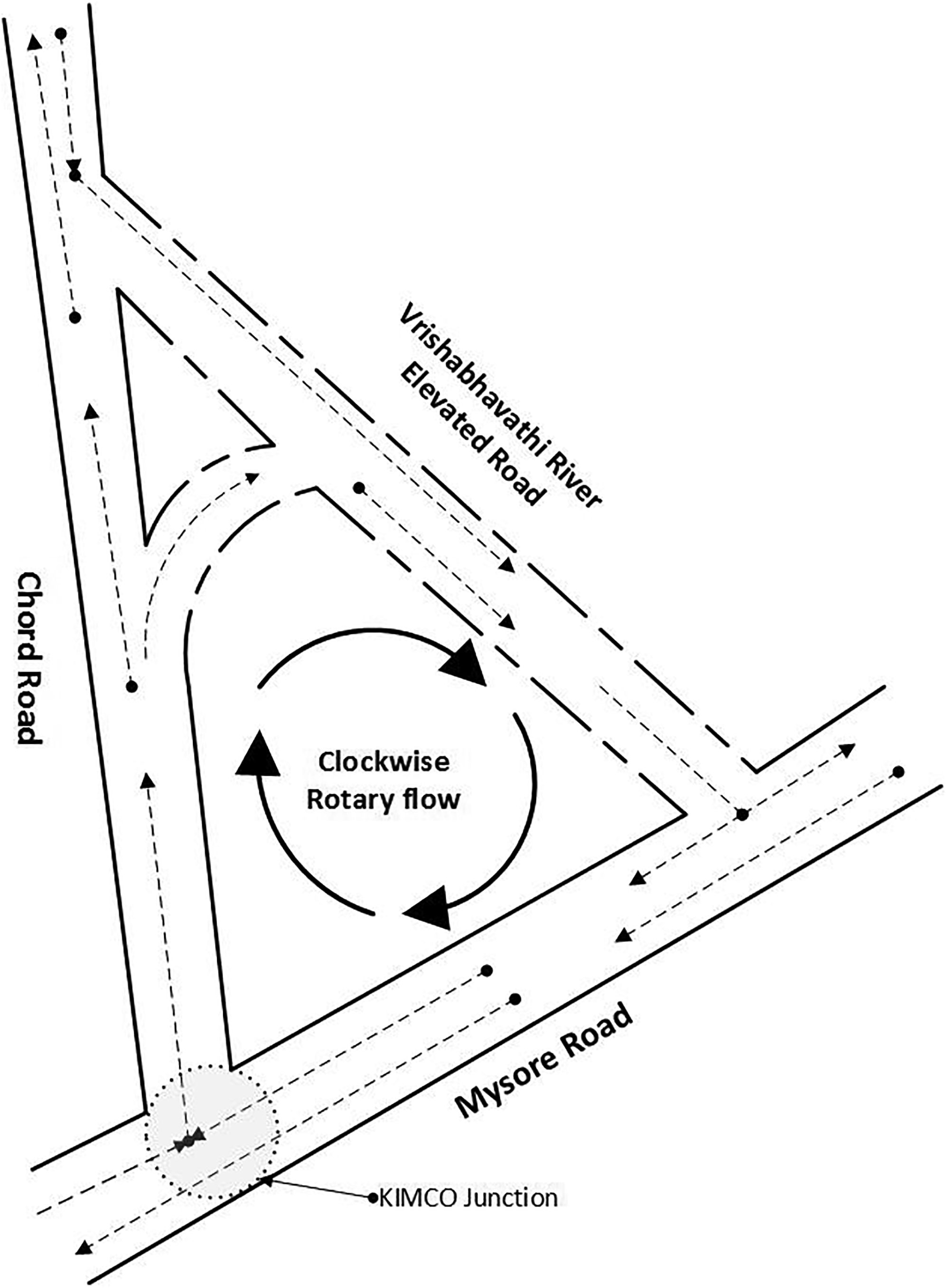
Schematic of the Vrishabhavati River Elevated Road (source: Govind Gopakumar).
According to the plan, the road surface would be supported on concrete columns that are lowered into the riverbed. The Vrishabhavathi River is a minor urban tributary within the Cauvery watershed. Despite being officially classified as a river, its portrayal in popular media is often as the “Vrishabhavathi drain” or even “storm water drain”, indicating the predominance that human and industrial effluents have acquired in its flows. Another noteworthy actor in the unfolding of the “technological drama” is the Gali Anjaneya Temple, a popular and historic Hindu temple located at the point where the elevated road joins Mysore Road. Across Mysore Road from the temple is the Mysore Road Bus Terminal, operated by Karnataka State Road Transport Corporation (KSRTC), a public corporation that operates inter-city buses in Karnataka. KSRTC’s Mysore Road Bus Terminal is a satellite terminal from where inter-city buses ply between Bengaluru and towns such as Mysore in south-west Karnataka. The design and execution of the VRER commenced in early 2006. The road was to be completed by February 2008 but despite more than 90 per cent of the construction work being completed, the VRER was only completed in April 2016, and that too only after several design modifications.
Design imbroglio 1 – Institutional Autonomy
The modifications were undertaken to counteract the displacement, by the VRER, of particular histories embedded in the place where the project was being constructed. Even as the construction of the project proceeded to the original design, the first major design complication was initiated by KSRTC. The VRER was originally designed with one down-ramp to provide dedicated access for KSRTC buses coming up Mysore Road to the bus terminal across the road. This ramp was designed as a flyover that would leap over Mysore Road to the terminal, allowing buses to enter the terminal without having to return back to Mysore Road and cross oncoming traffic. The plan reasoned that giving a seamless connection to buses would not only reduce traffic congestion but would also be convenient for bus drivers to access the terminal directly. KSRTC was expected to foot the bill for the dedicated down-ramp. However, even as the construction progressed on the VRER, KSRTC refused to pay for the down-ramp to its terminal. KSRTC is constituted as an autonomous public entity that receives little budgetary support from the city or state governments in running its services. Instead, the corporation is expected to meet its expenditure from its own revenue sources. Any source of expenditure is thus carefully scrutinised to ensure that the corporation can balance its accounts.
Even though KSRTC is a public entity wholly owned by the state government, the prevalence of an economistic logic can be traced to a particular institutional configuration that was established in the 1960s to manage urban infrastructures. India at that time was under the sway of Nehru’s project to centralise technoscience (albeit an instrumental vision) in India's nation-building efforts and socioeconomic development. 19 Technoscientific rationality promised an efficacious means to realise vital socioeconomic priorities of the national government. Within this project of national development, cities were considered already on the path towards modernisation. As historian Gyan Prakash notes, cities, according to Nehru, were aspects of planning and development and the job of national planning was to ensure that this aspect could be reinforced without interference from democratic politics. 20 Realizing this objective required a compatible institutional arrangement that offered a protected space for technoscientific rationality to be exercised. “New Public Management” that sought to streamline administration by introducing corporate-style governance to enhance efficiency, offered a ready pathway for achieving the Nehruvian project. 21 Specialised public corporations staffed by technical personnel that addressed a dedicated task of urban management was an appropriate response. Following this national trend, Karnataka notably created several specialised public corporations tasked with managing infrastructure. Staffed by engineers, planners, or other specialised technical personnel, these organisations were established with twin goals. First, to enhance operational efficiency and efficacy in the provision of infrastructures such as water supply, transportation, and urban planning by ensuring the predominance, at least on paper, of a technical rationale behind management decisions. Second, a governance space was created where operational autonomy is preserved, thereby allowing a technical rationale to predominate. Whereas, prior to this shift, infrastructures were managed by municipal line departments, with Nehruvian planning, the Karnataka government instituted dedicated agencies such as the Bangalore Water Supply and Sewerage Board in 1964, Karnataka Road Transport Corporation in 1961, and Bangalore Development Authority in 1976 to manage water supply, transport and planning. The flip-side of the operational autonomy that these organisations acquired through their corporate status was the complete elimination of budgetary support from the government. Severing any governmental budgetary strings, meant the corporation's financial status was solely dependent upon balancing its revenue with its expenditure outlays.
Design imbroglio 2 – Flooding
With the KSRTC backing-out of the project, there was no longer any need for the down-ramp crossing Mysore Road to the bus terminal. This prompted the first major re-design of the VRER in 2008. In the new design, since the VRER now terminated at Mysore Road, the height of the road surface above the river could be reduced. At the same time, despite removing one down ramp, it was still possible to conserve the larger design objective of clockwise signal-free flow of automobiles. Given the material savings from reducing the height of the road, designers implemented the change so that at the point where the VRER merged with Mysore Road, it was only 2 metres above the river. By itself, this modification should not have been an issue but together with another feature of the elevated road, it sparked yet another design complication.
The Vrishabhavathi river for much of its length winds through the city and it carries along a potpourri of plastic bottles, plastic bags, miscellaneous articles of clothing, carcasses, personal use products and other refuse of contemporary urban living that it acquires along the way. At the point where the VRER meets Mysore Road, the river encounters the columns carrying the elevated road. These columns are erected in the riverbed and track the course of the river for about 600 metres. According to the original plan, there were 21 columns supporting the weight of the roadway. The presence of these many columns slows the flow of the Vrishabhavathi river, which causes the river to precipitate some of its sediment and refuse load (Figure 4). The combination of a lower clearance for the VRER and the sediment deposit in the river have constricted the space available for water to flow through. In the dry season, the smaller volume in the channel is not a concern but in the monsoon season, the reduced volume causes the swollen river to overflow its channel and the smelly sewage-filled water to enter the wider urban domain outside the river.
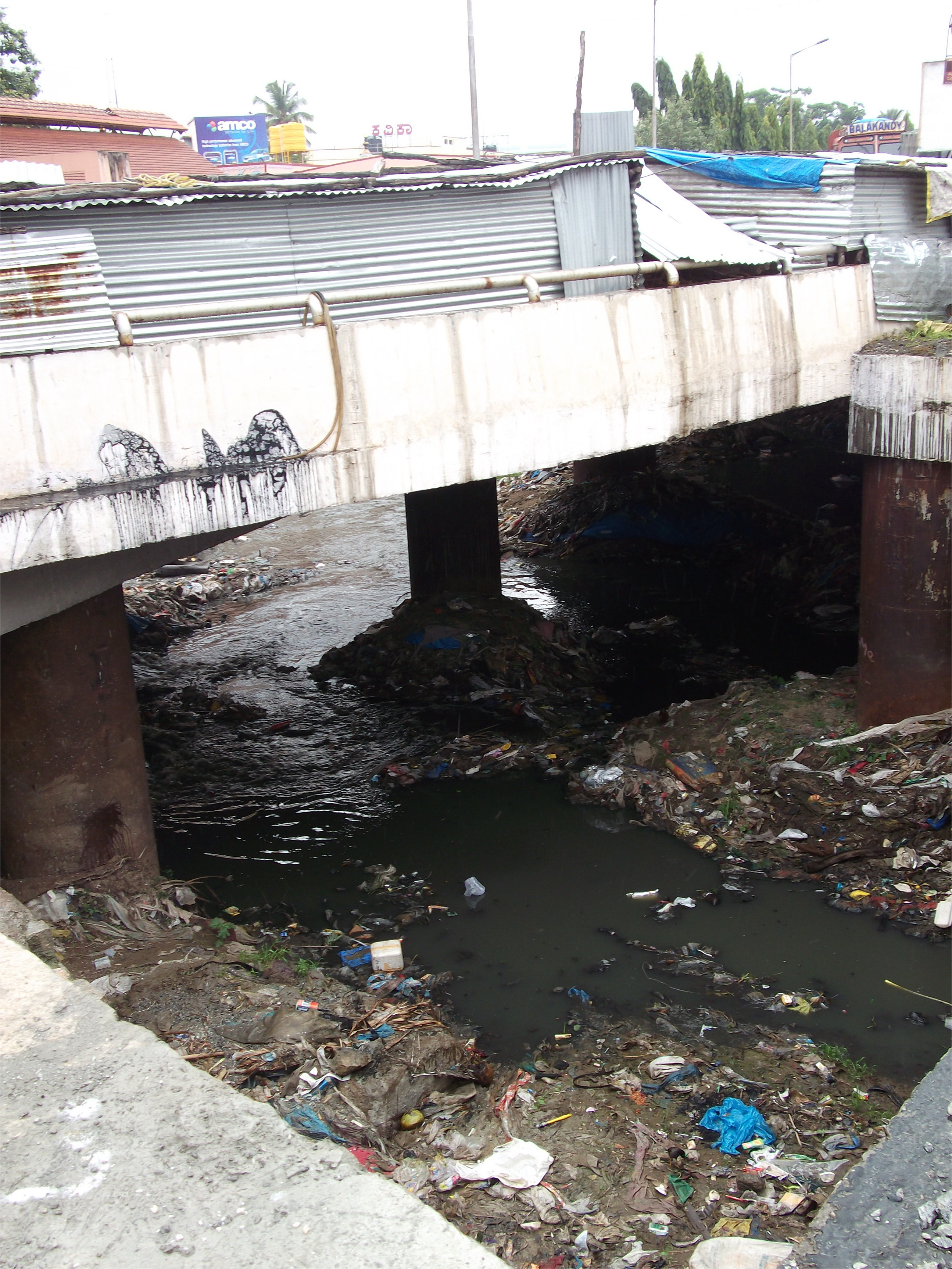
Sediments and refuse released by the river surrounding the columns of the VRER. (Source: Govind Gopakumar).
The breaching of this boundary between the river and the wider urban domain can be traced back to a discursive and material shift in the hydrological infrastructure of Bengaluru in the late nineteenth century. Bengaluru and its surrounding region relied on a pre-colonial system of inter-linked natural and man-made reservoirs (referred to locally as keré or as tanks by the British colonials) to store monsoon rains and utilise throughout the year. 22 The overflow from one tank would flow along riverine channels to tanks further downstream. Minor rivers such as Vrishabhavathi would aggregate the overflow from several of these channels to feed into the Cauvery river. In precolonial times, this native hydrological system was tended by local community institutions. The recurrence of epidemics of cholera and other transmittable diseases in the nineteenth century was a key impetus for the colonial government to incorporate British sanitary reform efforts into Indian cities through a range of sanitation measures in water provision, sanitation, housing and planning. 23 Bengaluru too possessed several tanks, many of them, one now finds, have been reclaimed for various private and public purposes, while the few that remain are vestiges – filled with refuse and sewage. Channels connecting these tanks have been re-signified as drains or waste carriers. 24 Indeed, in the popular press the Vrishabhavathi River is often referred to as just drain or stormwater drain or even sanitary drain. Till the nineteenth century, tanks and their overflow channels in Bengaluru were sources of drinking water and supported a distributed infrastructure of open channels and troughs to provide for the water needs of inhabitants. 25 The shift in designation happened in the context of a “technocratic paternalism” that perceived natives as uninformed or incapable and whose native systems of provision were vastly inferior to corresponding Western systems undergirded by the rigours of science. 26 Discarding these systems in their entirety would introduce natives to a modern, sanitised urban existence comparable with those in the European metropole. With this intent, pre-existing infrastructures of tanks, channels and troughs either fell into disuse or were functionally devalued as drains or sanitary drains. At the same time local community institutions managing these systems also withered and fell apart from the shifts in societal institutional structures. Over the years since this discursive and terminological shift, water channels such as the Vrishabhavathi River have lived up to their name. A variety of effluents intermingle within these channels even as they receive and bear solid wastes of urban existence.
Design imbroglio 3 – Postcolonial Moral Order
After the first design change, the effluent-filled Vrishabhavathi river flooded surrounding areas during sustained periods of monsoon rains. One place that was particularly susceptible to flooding was the Gali Anjaneya temple, located where the VRER joined Mysore Road. The fifteenth-century Hindu temple is popular with the faithful on account of several reasons (tied to the deity's unique qualities and mythical lineage) that grant it a particularly robust footprint within a religious landscape. Once floodwaters entered the sanctum of the temple and with images of the deity and priests standing in the foul-smelling waters circulating in the media (Figure 5), everyday rhythms of worship and devotions were disrupted. The interruption of everyday devotions precipitated a series of design modifications. In the immediate aftermath of the flooding, several high profile political leaders including the Chief Minister of the state of Karnataka, the Mayor of Bengaluru, the Minister in charge of Bengaluru, Members of Parliament, members of state legislative assembly, councillors visited the temple and the offending elevated road accompanied by an entourage of bureaucrats, engineers, and media personnel to assess the situation and direct project personnel to make design alterations. In response to this public scrutiny, designers demolished some columns and the constructed portions to raise the road level and to reduce the blocks in the river.
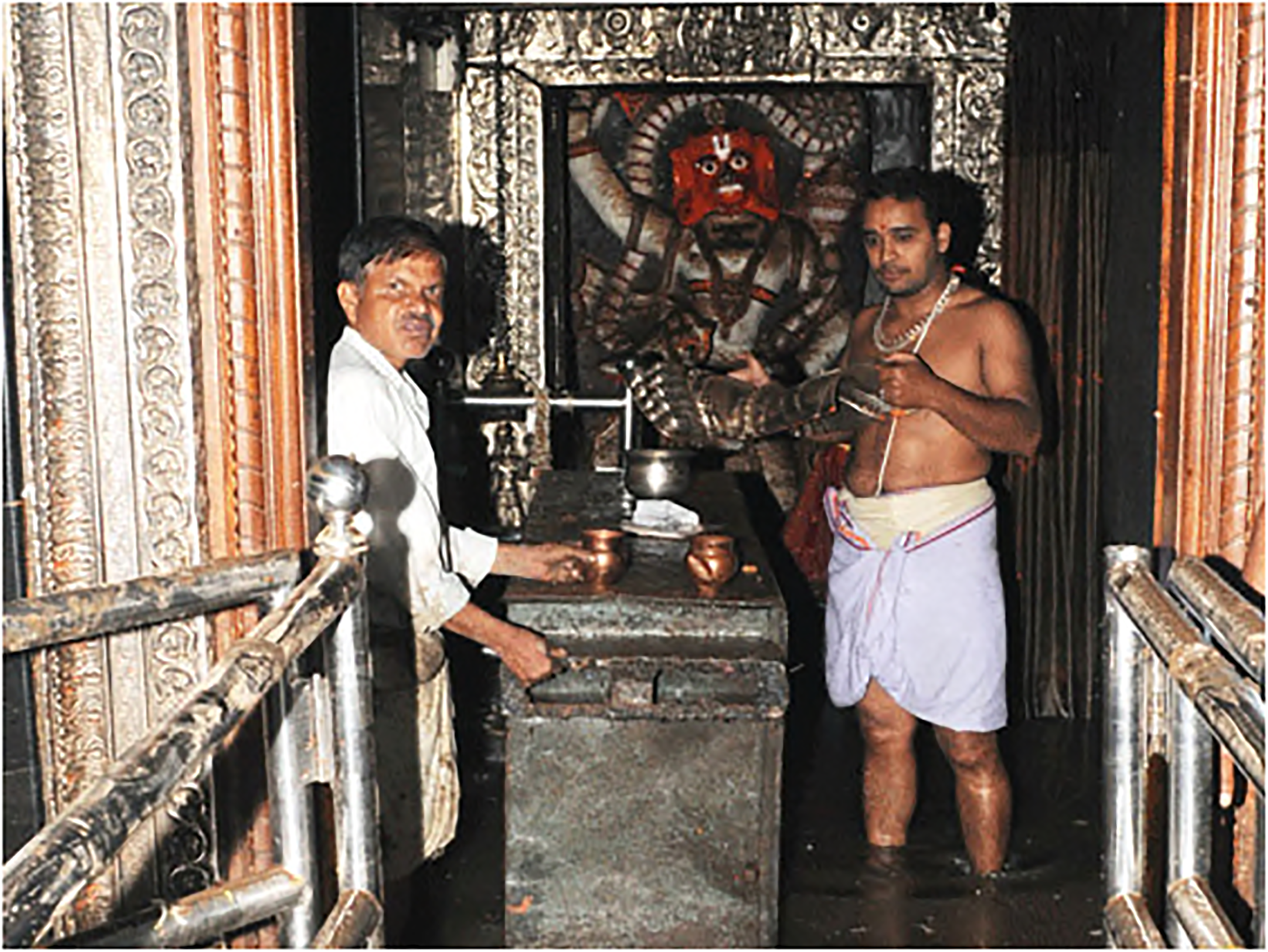
Floodwaters in the sanctum of the temple (source: Deccan Herald).
By March 2012, this round of redesign was largely complete but because the elevated road had been raised, only one of the down ramps could connect with Mysore Road. The ramp that directed vehicles towards the centre of Bengaluru city was level with Mysore Road, but the one that funnelled traffic away from the city towards Mysore, ended a few metres above the road (Figure 6). Without this down ramp, it would not be possible for vehicles coming from Chord Road to merge onto Mysore Road and thus would have to continue relying on the traffic light at KIMCO junction. The solution to accomplishing the design objective of signal-free travel was to raise the road-level on Mysore Road so that the down ramp connects with Mysore Road. This was accomplished by March 2017 (Figure 7). At that point, the clockwise rotary flow of automobiles was instituted and continues to this day.
The down-ramp of the VRER ending a few minutes above Mysore Road (source: Govind Gopakumar).
The clockwise rotary flow of automobiles after Mysore Road was raised at the Gali Anjaneya temple (in the foreground) to connect to the VRER (source: Govind Gopakumar).
The controversy surrounding the flooding of the popular Gali Anjaneya temple and the resulting involvement of several individuals occupying positions of political leadership in the city and the state, spotlights attention on yet another imbroglio associated with this project. This imbroglio is inflected by the coming together of a disparate array of historically rooted entities – the role of religion and the institution of temples in society, the nature of political leadership, and the particular constitution of governance in the city. Temples, especially the larger prominent ones, were not just nodes of ritual worship but existed in medieval southern India as a unique institution with multiple linkages that anchored social, economic, political, and cultural life of the region. 27 Its importance in the precolonial period (especially within the Vijayanagara empire, 1350–1650) arose from the multiple but ordered meanings and functions that drew together political authority, individuals, sects, castes, monasteries into coded cultural economic exchanges. Appadurai has eloquently described the symbiotic relationship between the temple deity and the political ruler with the ruler enhancing their legitimacy by sharing in the deity's sovereignty while also acting as the protector and benefactor of the redistribution of the temple's cultural and economic resources. 28 Such an arrangement embedded enormous power within the institution of the temple. 29 With the disintegration of the Vijayanagara empire in the middle of the seventeenth century, several regional states such as Mysore (where Bangalore was located) acquired independence but, nevertheless, sustained this complex multi-layered institutional arrangement till the onset of British rule. However, the extended period of colonial control followed by the current, ostensibly secular, postcolonial constitution has largely dismantled this complex politico-cultural complex surrounding the temple and replaced it with an administrative organisation for managing quotidian aspects associated with running temples. Shorn of their cultural-political connections, temples have shrunk to become a shell of their former states.
Despite this shift towards a mundane temple administration, models of political behaviour have retained elements of leadership derived from “cultural structures of the Old Regime”. 30 Price notes that political leadership in precolonial times, even at lower political levels, was kingly in the protective role they rehearsed in nurturing dharma or the moral order centred originally around the institution of temples (Ikegama proposes that kingship in the Mysore kingdom devised a hybrid notion of rajadharma that incorporated a European sense of improvement with sustaining dharma or the moral order). 31 This kingly aspect of preserving a moral order through acts of mercy and benevolence lies latent often subsumed within quotidian acts of captaining and leading their team forward. Acts of captaincy demonstrate skill in managing people, distributing resources and identifying opportunities and are vital to the success of the mission of political leadership. However, such captaining roles while necessary are not sufficient to propel a leader to the mercurial heights of popular adulation. 32 Controversies, for instance like those involving deities and their worship routines roiled by toxic muck, offer the optics to marshal a lordly leadership protecting their subjects from moral disorder. Thus, the rush of several political notables to be seen addressing the perceived threat to a way of life.
Cities, given the shifts in governance since colonial times, offer a particularly apt location for such lordly acts of political leadership. Precolonial Bengaluru possessed a native spatial form that allocated different quarters in the urban settlement to different castes or occupational groups. Endogenous leadership of each of these groups organised the residential, commercial, communal, and ritual spaces within their quarter with considerable autonomy. 33 Expressing impatience with native forms of urban organisation, in the first years of the nineteenth century after the British overthrew the Mysore kingdom, colonial administrators sought to reform the administration of the urban settlement. Their intervention consisted of two components – first, creating an impersonal administration not rooted within particular spaces or limited to particular caste groups but applicable generally; and second, materializing administration within dedicated office spaces that emphasised their detachment from the native quarters they sought to reform. 34 A key aspect of this impersonal administration was to fashion municipal administration with a semblance of representation by appointing councillors from different caste groups. 35 In the city, this shift was consolidated during the nineteenth century with the constitution in 1862 of the Bangalore city municipal board and with the Municipal Regulations act of 1871 providing the legislative basis for the Bengaluru municipality. 36 Since independence though, as mentioned earlier, the imperative for efficiency in municipal administration has resulted in several domains of infrastructure provision being carved into dedicated public corporations overseen by the state government. A further compounding factor is the largely derivative position cities occupy as creations of states within India's constitutional sharing of powers between the national and state governments. 37 This has meant that Chief Ministers and the state political leadership, routinely, occupy centre stage on urban affairs of Bengaluru.
The three historically-rooted design imbroglio's associated with the design and execution of the VRER are illustrative of the messiness of automobilisation in Bengaluru but also of the messy inter-linked histories displaced through the installation of the elevated road. In the next section, we consider what insight these imbroglio's offer in developing an ontology of the complex historical mesh of pre/post/colonialism embedded within the mobilisation and emplacing of automobility in Bengaluru and many postcolonial cities.
An Ontology of a Displaced Past
Automobilisation in India and several other countries of the Global South appear to possess an unbridled rise as city roads transform to host automobiles and more and more vehicles enter and lay claim to these changing roads. The advance of automobilisation exerts a growing footprint that consumes natural resources and is acknowledged as a leading factor in anthropogenic environmental change. Altering this situation requires a change in how people move. A paradigm of sustainable urban mobility seeks to displace the paradigm of automobility and thereby reduce our environmental burden. With this aim in mind, Goal 11 of the United Nations Sustainable Development Goals targets providing access to safe, affordable, accessible and sustainable transportation systems for all by 2030. The transition to a sustainable urban mobility paradigm has become a matter of necessity in Western cities with their settled auto-centric modes of movement. In the rush to craft solutions for sustainable urban mobility, historians have sought to caution against placing undue reliance on technological fixes. 38 They instead offer history as a resource to guide decision-making in the present and into the future (See for instance the call Martin Melosi has made for an urban history and environmental history that addresses decision-makers). 39 In making this call for history as a resource, historians of mobility have landed upon “usable past” as a strategy in Western cities to inform citizens and decision-makers and to spark debate among wider publics. Divall has proposed a call for a historiography that while accessible is also richly descriptive in the material and political realities of transportation regimes with the objective of exploring alternatives to automobilisation. 40 More recently, Ruth Oldenziel and others have sought to train historian's insights on sustainable urban mobility by emphasizing the usability of past in contemporary discourses and debates. 41 They suggest that usability of historical insight is germane to this discussion through its attention to mechanisms underlying the emergence and decline of particular mobility systems, the factors that side-lined early manifestations of sustainable mobilities, and the persistence of particular mobility infrastructures.
In piecing together a nonlinear, often tortuous, historical pathway, the past as a usable resource offers value in aiding reflection within a public discourse committed to transitioning towards sustainable urban mobility. The opposite is true of postcolonial countries like India where re-ordering streets and automobilisation have seen recent, and largely unprecedented, expansion at this scale. Public discourse continues to resonate to the techno-myth of automobilisation as an infrastructure pathway to realizing an aesthetic world-class city. 42 Re-shaping roads as conduits for an incipient motorisation, thus, possesses a moral imperative that is largely missing in Western contexts with their entrenched auto-centric mobilities. Considering the postcolonial context, what lessons does history offer to the ongoing process of automobilisation? The case of the VRER, described in this paper, is particularly instructive. Designers of the VRER had not expected that their construction of the elevated road would have the potential to seed such profoundly-different imbroglios. As we have seen, the three design imbroglios we encountered reveal deep historical roots in society, environment, politics, and culture. Taken together these imbroglios, if not threaten the project, certainly did delay its execution and call into question the potential for automotive infrastructures to buttress motorisation regardless of context. Automobility was ultimately conserved but on multiple occasions its operation was compromised through the design imbroglios bubbling-up during the construction process.
What lesson does the case of VRER offer for developing an ontology of the past manifesting in and through (auto)mobility? Usable past suggests a particular ontology of “history as a resource” for guiding future changes to achieve normative goals. But this notion does not quite grasp the resistance that historical configurations pose for the ongoing efforts of designers to roll-out smooth automobile flows. I propose instead that an ontology should necessarily encompass two aspects – first, a resistance that is unleashed through the designers act of emplacing infrastructures in the world, and second, a notion of agency that effects the resistance to the designer.
Globalisation has been regarded as a phenomenon with global flows circulating the planet in a space of flows all the while barely touching down in particular places. 43 Mobility theorists, on the other hand, offer an explanation that recognise mobilities as always embroiled in particular places through systems of immobilities and moorings that attend to, support and extend the flow of mobilities. 44 Cresswell offers the notion of friction to characterise the existence of place-based resistances that are engendered when mobilities traverse places. Friction, for him, possess a dual quality. On the one hand, friction as the name suggests, seeks to slow or halt mobilities. But on the other, friction is generative in that it provides the grip that enable particular kinds of mobilities. 45 The nature of the friction experienced is tethered to the place where it occurs. Asia, according to Cresswell, affords an arena for a particular kind of friction. 46 Although he argues that this Asian brand of friction decentres the universality of the Western experience of mobility, he does not offer an explanation why this friction exists beyond that they relate to the contours of the place where they originate. As demonstrated in the VRER case, the efficacy of Asian frictions relates to the interlinked lives of particular colonial and post-colonial histories. The friction manifests a particular historical agency that contends with the designers agency.
Friction is generated through the agency of past events continuing to live amongst us and contending with the course of events in the present. The key question underlying this claim is how does the past act in the present? In answering this question, environmental historians offer a way forward by having considered the question of who acts in the past? Historians like Linda Nash have answered the question by positing that it is not humans alone who possess agency to shape history. Nature, too, Nash would argue, exerts agency by shaping the intention with which humans effect change. 47 Thus, actions are understood as not sprouting forth from an unfettered human mind operating within a vacuum but are, instead, seen as products of interaction between humans and the environments they exist within. This notion of a composite agency is analogous to the agency of assemblages underlying the materialist ontology proposed by Jane Bennett. 48 Using the example of the cascading electricity blackout over a large swathe of north-eastern United States, Bennett argues that the case reveals an agentic continuum distributed over a range of artifacts, entities, forces, and humans that describes how the grid effected the blackout. The case shows how material entities, stray incidents, and institutional entities, act in consort with “historical” pieces of regulation to trigger a cascade response that precipitates the blackout. The cascaded collapse is an outcome of a particular alignment of displacements that a range of entities bring to bear upon the grid. The design imbroglios encountered in the VRER are analogous in that they indicate particular displacements that together threatened to undo the VRER and its design objective of smooth automobile flows. What is distinct about the displacements is that they are “becomings” of a postcolonial or colonial past.
The composite agency of the past in effecting displacements in the present and the resistance they pose to ongoing efforts to smoothen automobile flows indicates a specific ontology. History is not a resource alone, it is an unseen but agential presence at the table when (auto)mobility flows are being charted, planned, and implemented. History is an unpredictable, interlinked mesh of several (pre)colonial and postcolonial episodes, as we have seen in the VRER case, but it nevertheless acts with an agency that is analogous to a human actor. As an actor, history contests designed mobilities and effects revisions and changes. We have proposed an ontology of a displaced past to characterise this agentic response of history to contest ongoing efforts to plan and design urban mobilities. As a displaced past, multiple postcolonial, colonial and precolonial histories have become embedded within the design of the VRER. In so doing, they announce that mobilities possess a history – often a complex, tortuous, and non-linear history. The argument presented in this article counters the view that transport policy decisions are completely determinative of mobility infrastructures and cultures. History, as we have seen in the VRER case, is an agent that can underdetermine the shaping influence of policy and governance instruments. Returning to Massimo Moraglio's call for a (new) ontology of transport history, he exhorts the field to go beyond a history of movements towards movements as history. Heeding this call, this article proposes the ontology of a displaced past to consider how history embeds itself within movements and mobility infrastructures thereby shaping the experience of mobility.
Footnotes
Declaration of conflicting interests
The author declared no potential conflicts of interest with respect to the research, authorship, and/or publication of this article.
Funding
The author disclosed receipt of the following financial support for the research, authorship, and/or publication of this article: This work was supported by the Social Science and Humanities Research Council, Canada (grant number 435-2020-1112).