
Abstract
This article contributes to the research on the expansion of the Swedish post-war road network by illuminating the role of tourism in addition to political and industrial agendas. Specifically, it examines the “conceptual construction” of the Blue Highway, which currently stretches from the Atlantic Coast of Norway, traverses through Sweden and Finland, and enters into Russia. The focus is on Swedish governmental reports and national press between the 1950s and the 1970s. The article identifies three overlapping meanings attached to the Blue Highway: a political agenda of improving the relationships between the Nordic countries, industrial interests, and tourism. Political ambitions of Nordic community building were clearly pronounced at the onset of the project. Industrial actors depended on the road for the building of power plants and dams. The road became gradually more connected with the view of tourism as the motor of regional development.
Introduction
Tourism is an essential aspect of modern societies. Holiday pay, cars, and modern highways have become almost synonymous with modern recreation. 1 The notion of familial car travelling became especially popular between the 1950s and 1970s. The meanings that were established with road travel have become an important part of the modern experience of vacation and the pursuit of both rest and movement as well as adventure. 2 Clearly, there are links between growing tourism and improved communications and transport opportunities. 3 Roads also shape the relationships between travellers and the natural landscape and may give rise to tensions concerning how the natural landscape should be used. 4
Infrastructure and road projects bring together many stakeholders along with different and sometimes competing political, social, economic, and cultural views, which also change over time. 5 Large international road plans were constructed in Europe in the interwar and post-war periods based on the vision of a future tourism that became knotted with other political and economic interests. 6 One suggestion from 1930 concerned a road from Calais to Constantinople, another suggestion concerned a road from London to Istanbul. 7 Tourism and the modernisation of infrastructure and international road networks were also an essential aspect of the European Recovery Plan (better known as the “Marshal Plan”) that was intended to strengthen the European economy, “market” Europe to USA, and advance transatlantic travelling. The international E-road network that now crosses the national borders of European countries also emerged in relation with the vision of an interconnected Europe where tourism would play a significant part. 8
Studies on the expansion of the road network in the post-war period have generally paid more attention to the car industry and the major breakthrough of the passenger car than the role of tourism. 9 Previous research on the post-war expansion of the Swedish road network sheds light on the complex relationships between the road administration, the technical expertise, influential lobby groups and political interests. 10 Similar relations developed in other Nordic countries as well as in the USA. 11 This article complements research on the expansion of the Swedish road network in the post-war period by studying a case that highlights the importance of tourism and its entanglements with politics and industry: The Blue Highway.
The Blue Highway (Blå vägen in Swedish) is a road in Northern Europe that stretches between Mo i Rana on the Atlantic Coast in Norway, Västerbotten county in Sweden, Ostrobothnia in Finland, and Pudozh near Petrozavodsk in Russia (Figure 1).
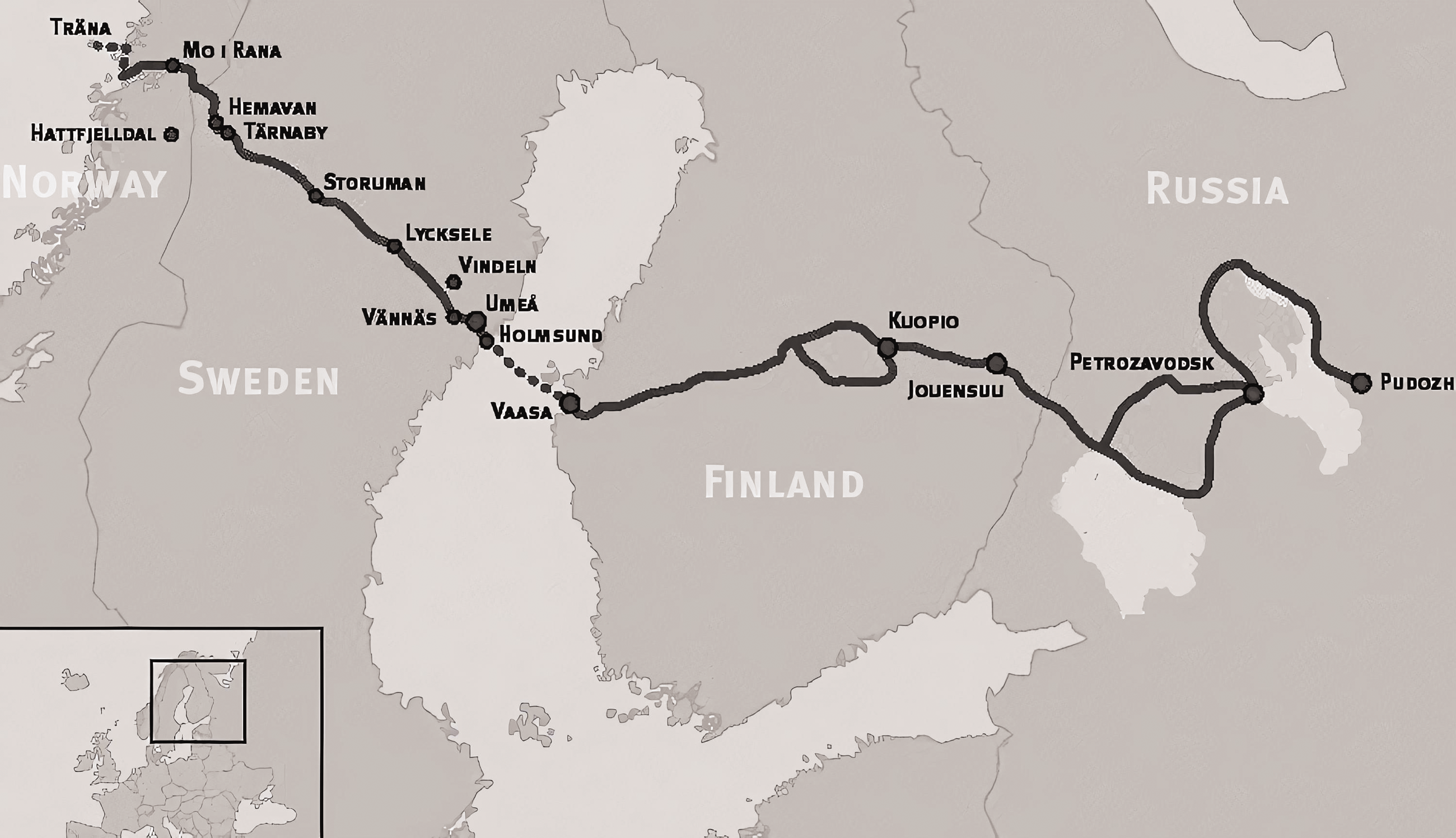
The Blue Highway, which currently stretches from the Atlantic Coast of Norway, traverses through Sweden and Finland, and enters into Russia. Source: Authors' elaboration.
At present, it is commonly referred to in tourism and travel contexts, for instance, in terms of a road going “through sparsely populated countryside or wilderness, with great opportunities for outdoor life.” 12 The initiative for constructing a modern road was taken in the 1950s, but there were commercial and meeting places along the route long before that. 13 The section between Umeå and Lycksele in Sweden was built during the first half of the nineteenth century. The first road crossing the border between Sweden and Norway was completed in 1939. The contemporary road stretch was inaugurated in 1964 and became a European highway (E79) in the early 1970s. It is now called E12. From the early 1970s into the present, ferries transport vehicles and their passengers between Holmsund in Sweden and Vaasa in Finland year-round. The ambitions of extending the road into Russia were realised after the end of the Cold War.
The Blue Highway was built in the light of political ambitions seeking to further transnational connections after the Second World War. It was also a time of extensive industrial expansion. Forestry was modernised and modern hydroelectric plants were constructed in many Swedish rivers. The rural population also decreased following urbanisation. At the same time, the tourism industry grew. The construction of the modern road in the 1960s attracted the interest of the Swedish press and media as well. The name, the Blue Highway, alludes to the fact that the road goes along the Ume River, but the road allegedly got its name after being marked with a blue line on a map. 14
The purpose of this article is to explore the “conceptual construction” of the Blue Highway in Sweden, centring on the period between the 1950s and 1970s. The concept of conceptual construction refers to the historical meanings that were ascribed to the Blue Highway in Swedish governmental reports and national press reporting.
The article is informed by (anthropological) scholarship that takes as a starting point that the meaning of infrastructure and roads is socially constructed and that this meaning-making is not constricted to the material road building site but is rather an ongoing process taking place in different arenas involving different actors. 15 Meaning-making does not have a fixed beginning or a clear end. Moreover, the meanings that roads acquire enable certain economic, social, cultural, and historical relationships. 16 The processes of meaning-making are thus essential for the social, political, or cultural significance roads acquire over time. 17 This concerns, for instance, how transportation infrastructure is “inhabited by visions, dreams and expectations,” especially concerning the potential of such infrastructure to further new relationships and cross-border connections, although there may be challenges to realising these ambitions. 18 Accordingly, studying the meanings that roads acquire open windows onto larger issues concerning modernisation, connectivity, and economic development among others. 19 In addition, historical research underscores how the meanings of roads are also changing. The reasons and arguments behind infrastructure investments vary between actors and contexts, and the rationale behind specific initiatives may change and connect with other interests as the process unfolds. 20 Indeed, the road network has many functions and expectations, and fantasy play a significant part in the design and use of roads. 21
I identify three overlapping meanings of the Blue Highway broadly labelled politics, industry, and tourism. Firstly, what later became the Blue Highway began primarily as a political initiative in the 1950s for improving the relations between the Nordic countries and especially between Norway and Sweden after the Second World War. Secondly, the industrial meaning was particularly prominent from the latter parts of the 1950s, especially in relation to the construction of hydroelectric power plants in the Ume River that run alongside the Blue Highway. Thirdly, the significance of the Blue Highway in relation to tourism was pointed out already at the onset but became gradually more important in the 1960s onwards.
These sites also display friction, challenges, or exclusion. For example, the Blue Highway increased connections to and from some areas while it decreased the connectivity of others in relative terms. New relationships were forged but new boundaries were also constructed. The modernist narrative on which the road project was based excluded opposition from groups such as the Sámi population. Stereotypes were reactivated when areas around the Blue Highway became part of a national and international tourist economy. However, tourism may also provide a venue for challenging dominating narratives and stereotypical views of the region and its population. The meaning of the Blue Highway as a tourist route should also be seen in relation to an image of northern Sweden that is presently emerging. Rather than focusing on the industrial history, this narrative is underscoring how northern Sweden is becoming a recreational or pleasure zone for tourists. 22
Different genres of source material are used for illuminating the different meanings of the Blue Highway. Governmental commissions and public investigations shed light on the political motives and the links between politics and industry. They also acknowledge the significance of tourism. Literature and the national press (for instance large national dailies and evening newspapers such as Dagens Nyheter, Svenska Dagbladet, Aftonbladet, Göteborgs Posten, and Expressen) are explored to further illuminate the meanings of the road in relation to tourism. The national press is significant in positioning the Blue Highway in relation to the view of national but also international tourism.
The Swedish road system was nationalised in 1944 to a large extent based on the view that road traffic was no longer a local matter but rather a national issue which required a national or unified administration. 23 The Royal Board of Roads and Water Building (Kungl. Väg- och vattenbyggnadsstyrelsen, hereafter VoV) was responsible for the national road administration, and a regional office was established in each county. There were also several influential actors outside of government. The Swedish Road Association (Svenska vägföreningen, henceforth SvF) served as a hub for mobilising various actors in the Swedish post-war road and car lobby. 24 SvF had a major influence on the large National Road Plan for Sweden (Vägplan för Sverige), which was instrumental in the efforts of the Swedish government of improving the road network over the 1960s and 1970s. 25 This governmental work thus largely spans the period with which this article is concerned.
According to the national road plan, better roads would solve both the capacity and safety problems linked with increasing motor traffic. Criticism of the road plan was commonly moderate and concerned, and included discussing issues such as the priorities between the road network and the railway system. 26 The technical expertise played a leading role in formulating the modernisation of the road network as an “objective” technical matter rather than a political issue. 27 There was also a strong political support from the Swedish government, for which, among other things, an increasing number of car owners was a symbol of the improved financial state of the population. 28
General changes in the late 1960s helped change the conditions and organisation of the public road administration. The political influence of the Swedish municipalities increased. The municipalities also acquired their own expertise in the field of spatial and infrastructural planning. Road construction from the 1970s onwards was increasingly based on regional negotiations between different parties and representatives of both the public and the private sector and industry. 29 The decisions formally taken by the central government were often anchored both administratively and politically at a regional level. This should also be seen against the backdrop of the general criticism of the public administration and the decentralisation of the Swedish state apparatus at the time.
Thus, there were strong actors and interests behind road construction in Sweden that could act for ensuring that new roads appeared as priority solutions to important problems. The state administration provided a framework within which the construction of the Blue Highway commenced, but the actual road construction was not financed by the national road plan. The municipalities of Västerbotten county and industry actors were instrumental in the building of the road. Over time, the Blue Highway became more connected with tourism as the driver of regional development. The same road was thus considered a solution to different problems by different actors.
A Nordic community building project
The Second World War gave rise to tensions between the Nordic countries, especially as the transportation of German soldiers that had been essential to the occupation of Norway passed through Sweden. 30 New roads and improved communications were part of the post-war reconciliation work. The Nordic Council, the official body for inter-parliamentary co-operation among the Nordic countries, was a leading actor. There were only a few roads between Sweden and Norway in the mountainous northern parts of the countries. The roads were often of poor quality and could not be used for modern motor traffic. A first post-war road was constructed between Storlien, Östersund in Sweden and Trondheim in Norway. In the mid-1950s, VoV was assigned by the government to investigate the need for an additional road link.
Much effort went into the idea of strengthening the community and cooperation between the Nordic countries after the Second World War. Nordic councils were established. There were also serious discussions on establishing a Nordic defence union. Roads were considered fundamental for increased mobility and integration between the countries. Since 1952, Scandinavians have been able to travel without a passport between Sweden, Norway, and Denmark. This was extended to Finland in 1953 and Iceland in 1955. Passport control for all travellers was moved to the outer borders of the Nordic countries in 1958. In the parliamentary debate in the early 1960s on the traffic development in Sweden, it was pointed out that an investigation carried out by the Royal Institute of Technology in Stockholm showed that the number of border crossings between Sweden and its neighbouring countries more than doubled in the 1950s, allegedly reaching 21 million in 1959. 31 The motivation for constructing new roads and improved communications should also be seen in the light of the ambitions on a global scale of creating better international relationships after the Second World War.
VoV’s investigation showed that the best place to build the new interstate road was between Tärnaby in Sweden and Mo i Rana in Norway. This road would benefit a larger part of the population than other alternatives would. It would also have a major impact on business and tourism. While the study pointed out that the contacts between Sweden and Norway in these areas had a long history, it also noted that: “Unfortunately, the practical possibilities for these contacts have been hampered by inadequate road links.” 32 The road between Umeå and Mo i Rana was assumed to be of great importance from an “inter-Nordic point of view.” 33 Furthermore, the road on the Swedish side was described as an “artery” of Västerbotten county. 34 It was viewed as a means of retaining the population by offering the same welfare services as the urban regions that emerged primarily along the Swedish coast. This assessment guided the debate in the Swedish Parliament as well, which also underscored the “inter-Nordic” agenda of the road project. 35
The press reports from the opening ceremony of the Blue Highway in 1964 also stressed the potential of the Blue Highway of contributing to improved relationships between the Nordic countries as well as the ambitions “to make this road a major traffic vein” between Norway, Sweden, and Finland. 36 A few years later, media reports also testified to the far-reaching hopes of the road going all the way to Petrozavodsk on Lake Onega in the Soviet Union, thereby helping to open up the rigid borders between the East and the West during the Cold War. 37
The Blue Highway can be understood as an arena for what Orvar Löfgren, in another context, refers to in terms of channelling cultural energy. 38 There was a clear enthusiasm about the Blue Highway and the ambition to create new relationships at a time of grand political restructuring. Many actors joined forces in trying to realise these visions. The road project was not entirely uncontroversial, however. The Blue Highway illustrates what previous studies have pointed out concerning roads and infrastructure more broadly, namely that transportation infrastructure connects remote areas and enables integration both within and between countries, but there are often tensions if not conflicts over the decision-making processes and about whose knowledge and visions should be prioritised. 39 Motions in the Swedish parliament advocated another road alternative further north, from Arvidsjaur in Sweden to Rognan in Norway. 40 Controversies over the positioning of this road were based on how communication links were deemed crucial in the distribution of resources and opportunities, especially in relation to the major public initiatives that were launched in constructing the modern Swedish welfare state. This belief in connectivity has been a cornerstone in the emergence of the modern “infrastructural state.” 41
In addition, a national-oriented discourse emerged in relation to and sometimes in tension with the inter-Nordic one. The press underscored how Sweden had invested almost SEK 40 million and had built nearly the entire road stretch, while hardly anything had been done on the Norwegian side of the border. 42 The press also noted that mundane events could spark controversy. 43 For instance, at one point, the road had not been ploughed on the Norwegian side. Swedish press reported that Swedish workers who had tried to make the road passable in Norway could risk penalties and fines for exceeding their authority. 44 In Norway, too, post-war roads were built with the intention of furthering international connections as well as for advancing the economy and specific forms of tourism such as camping. 45 Examining the Norwegian efforts of realising the Blue Highway, which would also allow a further assessment of the statements of the Swedish press, is, however, beyond the scope of this study.
Industry and development
The Blue Highway was not included in the Swedish National Road Plan (SOU 1958:1). This meant that even though there was political support for the road project, there was not necessarily any public funding allocated for realising it. The road was eventually financed by the Royal Waterfall Board (Vattenfall) and the municipalities of Västerbotten, which demonstrates how political and industrial interests were brought together to make the road possible.
Vattenfall was the public power company responsible among other things for building the hydroelectric power stations in the Ume River that were being constructed in the late 1950s and 1960s. Modernised roads were deemed necessary for this construction process. The forest industry was also an important stakeholder in the Blue Highway project. The forest industry played a crucial role in the Swedish economy, and it was especially important for them to have roads in the northern parts of the country. The prospect of a road to an ice-free Norwegian port would be of great value for the extensive transport and export of timber, especially when key parts of the existing road closed during winter. Modernised roads also facilitated the transition from log driving to transportation on trucks, especially as new dams were built that made river transport impossible.
In the governmental investigations preceding the road building project, the County Administrative Board of Västerbotten stressed their vision to establish a “free trade region” that would strengthen the trade and commerce between Sweden and Norway, which would also benefit local interests and help to retain the population and labour force in the region. 46
More stakeholders were engaged as the road project developed. The so-called Blue Highway Association (Blå vägen-föreningen) was founded in the early 1960s with the aim of supporting the realisation of the road. The Association, which still exists, consisted of municipal representatives (who in some cases were also members of parliament), county council representatives, and tourism actors from the different municipalities. The business sector was also represented. There were representatives of Norway and Finland as well, but they were fewer in comparison. The Blue Highway Association grew as the road construction unfolded. It also attracted more members in Norway and Finland. One of the primary functions of the Association was to coordinate action and mediate between the different interests and stakeholders. It also lobbied for the importance of the road and sought to further political as well as financial support. The fact that the then-Minister of Communications in Sweden, Gösta Skoglund and his Norwegian counterpart, Erik Himle, spoke at the Association’s annual meeting illustrates the political interest it attracted. This also caught the eye of the national press. 47
Skoglund was an important supporter of the road construction project. He was deeply rooted in the regional politics of Västerbotten county. He worked and lived in Umeå, the capital city of Västerbotten. Among other things, he had been involved in questions concerning regional media and education and in the establishment of Umeå University in 1965. He later became the chairperson of the County Council as well as the Museum of Västerbotten. He also represented Västerbotten in the Swedish Parliament. In addition, he was a member of the Nordic Council.
The first meeting of the Blue Highway Association, that was held in Storuman in the late summer of 1962, received national attention in major Swedish newspapers. 48 Lennart Hartin, a leading figure and chairman of the Blue Highway Association’s international department commented that: “The Blue Highway primarily serves the population and business community of Nordland in Norway, Västerbotten in Sweden and Ostrobothnia in Finland. We want to launch the road as a transport route for both short and long journeys and demonstrate its importance for business, society and the individual.” 49 The press was instrumental in building support of the road both locally, regionally, and nationally. Hartin later pointed out that: “It was a matter of creating effective propaganda, getting tourist associations and transport companies and similar associations to become interested.” 50 Hartin also produced shows for national radio about the road’s construction in 1962.
The Blue Highway road plans should also be seen against the backdrop of a problem-oriented view of northern Sweden. In the 1940s, a large investigation was carried out by the forerunner of the present-day Swedish Research Institute of Industrial Economics to address what was referred to as “the problem of Northern Sweden” (Norrlandsproblemet). The investigation examined how problems that it pointed out should be handled, especially underscoring the growing unemployment, depopulation, and the challenges facing the forest industry and agriculture. 51 There was a strong belief in new communications, improved infrastructure, and modernised industry for the exploitation and refining of raw material and natural resources. There were serious discussions about the potential of building airports as well. Accordingly, it was important to attract public infrastructural projects and investments.
The image of the problems of northern Sweden has a long history. Gustav Rosén, for instance, used a deliberate social propaganda approach to mobilise the authorities for ameliorating the poverty of Västerbotten’s mountain areas in the 1910s. Rosén was a sociologist, newspaper editor, member of parliament and governor of Västerbotten. He linked the problems he identified to, among other things, the lack of roads and the poor road quality. 52
During the interwar years, more roads were built in the northern Sweden than in the south but the roads were of low quality, built mainly for horse and carriage, while the road network in southern Sweden was being upgraded to handle motor traffic. 53 Road construction was part of a long-term transformation of the agrarian society towards increased industrialisation. 54 It was also a way of creating jobs during the recessions in the 1920s and the 1930s. Road construction work was a seasonal complement to other incomes; but it was carried out under harsh circumstances, and the salary was typically low. 55
Against a broad social, economic, and cultural base, then, the Blue Highway was framed as an answer to fundamental questions and problems identified in the northern parts of the country. In this context, the Blue Highway appears as a largely uncontroversial project. This consensus did not only include the ways in which engineers and technological expertise could transform political questions into “objective” technical solutions. The material examined in this study also excludes the interests of the Sámi people. Historically, the Sámi people has had little influence over the exploitation of northern Sweden concerning, for instance, the establishment of tourist facilities, hiking trails and national parks. 56 Press reporting referred to the road’s relationship to the history of the colonisation of the northern Sweden, stating that: “The modern Blue Highway tourist trail is an ancient highway. Along the valleys of the Ume River and the other northern rivers, settlers advanced when they once colonised the north.” 57 The report also noticed the conflicts over the rights to land. This is not saying that the Sámi had necessarily opposed the road, but their absence from the governmental decision making is illustrative. An influential imaginary underscored the close ties between the Sámi people and nature which sharply contrasted against prevalent rationalities supporting the industrial exploitation during the twentieth century. 58 In broader terms, the modernist-industrial narrative effectively excludes that which cannot be assimilated to a narrative of technological and industrial expansion. 59
A tourist road
The public investigation carried out by VoV in the 1950s concerning the location of the road between Sweden and Norway stressed that the future road should have a concrete value for the tourism industry. According to this vision, Västerbotten could expect a similar boost as had the county of Jämtland, where the previous post-war road between Sweden and Norway was built. 60 The investigation also pointed out that there was an established co-operation between tourist organisations in Finland, Norway, and Sweden, which would also contribute to advancing the tourist traffic. In addition, there was already a reported interest in travelling between Vaasa and Mo i Rana. The Blue Highway was thus invested with tourist expectations early on, promising to increase and advance the competitiveness of Västerbotten county. Gradually, the importance of the road to the tourist industry became more significant. Service facilities such as petrol stations, motels and rest areas developed in tandem with the increasing motor traffic. 61
At the end of the nineteenth century there were tourist connections to the mountain world in Abisko, further north in Sweden. The railway was an important vehicle of cultural distribution between the different parts of the country, 62 although mountain tourism was commonly an elite phenomenon. The tourism industry in Jämtland was also developed. 63 Västerbotten had no similar industry. When Västerbotten’s tourism industry started to take off, investing in railroads was no longer timely. The car was more popular than the railway, and it could draw a broader public to the tourist attractions. In connection with the building of the Blue Highway, investments were made at the mountain resorts in Hemavan and Tärnaby in the mid-1960s, which was also noted in the national press. 64 The new form of round trips that were becoming popular were also quite expensive, comparable in price to similar trips to Italy. 65
Expectations were high. In the national press, a vision was crafted of an extensive tourist traffic where it was estimated that hundreds of thousands of tourists would travel along the Blue Highway in the first year and, after that, these numbers were expected to rise. 66 The newspapers also noted that the Blue Highway was part of the bold efforts to preserve the region and retain the number of inhabitants. The press depicted the situation that had emerged by declaring how: “The tourist gets in when the villagers get out.” 67 This evidently referred to the depopulation of the inland that happened in tandem with the emergence of a vision according to which the inland was increasingly being depicted as a recreational area for tourists.
The Blue Highway was part of the advertisement campaigns of Västerbotten county and the municipalities of Västerbotten that were distributed through the larger Swedish dailies. 68 The Blue Highway was marketed under the name “Via Lappia,” which could instil some of the exotic allure of northern Sweden. Later governmental commissions also stressed the importance of the Blue Highway for the inland economy and especially the mountain tourism of Västerbotten as well as bordering parts of Norway. These reports relied on statistics and the quantification of visitors and traffic. 69
Hans B. S. Pärson became the chairman of the Blue Highway Association. He presented his views on how the road would contribute to the region’s development in an editorial in the Swedish nationwide evening newspaper, Expressen, in 1968. Pärson’s remarks are interesting as he incorporated the Blue Highway in a comprehensive view of what he considered pressing issues. To Pärson, the potential solutions included a combination of infrastructural investments, personal responsibility and changing attitudes: a prerequisite for an increased tourism industry for this population is better communications. Charter flights to inland airfields are an option. One request is to expand the ‘Blue Highway’ from Umeå across the mountain area to the Norwegian Atlantic coast and have it trafficked by subsidised speed buses. Similar opportunities could be created in other counties… If sparsely populated areas are to live on, and perhaps even live up again, we must get rid of the spirit of resignation. One must find new living conditions in these new times. And it is simply necessary from the point of view of the whole country that there are people in sparsely populated areas in order for us to be able to exploit the valuable natural resources.
70
Press reporting also illustrates how the distinctions and the unique selling points that are arguably essential in the globalised tourism economy were produced. 72 Three different images were driving the narrative of the Blue Highway as a tourist route. Accordingly, the Blue Highway offered, as it were, a road trip through both time and space. Firstly, a trip along the Blue Highway provided, according to a press report: “the full range of the different nuances of the Swedish landscape.” 73 That is, a modern university town in Umeå, fertile agricultural areas in the coastal region, and sparsely populated hinterlands as well as old farming communities with some deserted houses and farms. The trip would also offer miles of “forests and barren land” and “a fascinating mountain world where the snow remains all year round.” 74
Secondly, old stereotypes and anecdotes were reactivated. A report in Dagens Nyheter, a major national Swedish daily, was written in a kind of dialogue with Carl Linnaeus’s “Tour in Lapland,” which he conducted in the 1730 s. Dagens Nyheter thought Linnaeus’s travelogue was a “pleasant addition to the car and tourist maps for those whom this summer travel by car or bus along the Blue Highway, the new tourist trail in the north.” 75 Linnaeus’s assessments of the region were, however, rather harsh. Dagens Nyheter cited how Linnaeus thought he had passed through the river of Styx after visiting Lycksele, one of the larger inland municipalities along the Blue Highway. Linnaeus was quoted saying that: “A divine could never describe a place of future punishment more horrible than this country, nor could the Styx of the poets exceed it. I may therefore boast of having visited the Stygian territories.” 76 According to Dagens Nyheter, Linnaeus would have been surprised at how this area had now become an international tourist trail. Dagens Nyheter also noted that Linnaeus was not always negative. Among other things, he appreciated some of the nature and especially the sunrise.
The Blue Highway also facilitated the exhibition “Västerbotten displays” (Västerbotten visar) in 1963, which is another example of the creation, use and capitalisation of the exotic aura of the inland areas of Västerbotten. Tärnaby municipality would contribute with the reconstruction of a Sámi camp and Norsjö municipality would be represented by “the nationally known Norsjö Bear.” 77 The tourist economy arguably conceal how representations, cultural distinctions and stereotypes are conditioned by the global economy and overshadows issues of politics, power, and economic relations. 78 While this may certainly stand in the way of cross-cultural dialogue and understanding, 79 it has also been pointed out that the tourism industry has enabled the present-day Sámi people to uphold certain traditions and advance certain political interests. 80 The tourism industry may thus also provide arenas for countering stereotypes.
Thirdly, the Blue Highway illustrates the complex relationship between tourism and infrastructure. While the industrial expansion was necessary for supporting the construction of the Blue Highway, it did not always help to increase the tourism value of the area. Lennart Harting concisely addressed the matter in the national press in the mid-1960s, expressing how the landscape from “a touristic point of view… is despicable.” 81 However, he also noted that the industrial constructors had sought to compensate for the loss of beautiful views. 82 For instance, one of the inland’s largest swimming pools had been built. There were open-air baths with temperate water and campsites with electric heating for the tents and special parking areas for caravans. There were also lakes with stocked fish. There were even those in the 1970s who claimed that the hydroelectric power plants were in themselves attracting tourists but that idea was normally questioned. 83
Even as the meaning of the road as primarily a tourist route became increasingly dominant in the 1970s and even more so in the 1980s, the importance of the industry to the construction of the Blue Highway was stressed. Sven Roosqvist, the tourist manager of Lycksele at the time, claimed in the mid-1980s that: “tourism is Västerbotten’s largest industry, if you take into account the effects it has. And that this is mostly due to the [dam building] and the Blue Highway is undoubtable.” 84 In many present-day contexts, the Blue Highway is described primarily as a tourist route, while the links to industrial heritage are often downplayed or omitted. This should be related to how a new historical narrative is being formulated. Rather than primarily stressing the industrial history, northern Sweden is understood as a recreational zone for tourists. 85 The Blue Highway provides a window onto some of the historical actors and processes behind this emerging narrative and how it relates to the expanding post-war road network.
Conclusion
Like in several other European countries, Swedish post-war road building was entangled with broader political visions and industrial agendas. These infrastructural projects were a crucial part of their modernisation efforts. The Blue Highway was produced outside the major national road plan of Sweden. Several actors and interests were brought together in making the road possible. This article identifies three overlapping meanings of the Blue Highway: the political, the industrial, and the touristic. Rather than establishing mutually exclusive narratives, there are overlaps and exchanges between these different meanings.
The political interests set the project in motion as part of a broader ambition of strengthening the relationships between the Nordic countries in the 1950s. Connections and improved infrastructures of transportation of both goods, people, and information were at the heart of this effort. The Blue Highway also represented a vision of new connections beyond the boundaries of the Cold War, which, as it were, was realised in the 1990s. The national road administration apparatus provided the framework for the road project, but there was no unified governmental understanding of how road constructions should be prioritised. The political decision of constructing the Blue Highway was not backed with funding for building it. This political agenda receded as regional politics became more pronounced. Government policy of the late 1950s served as a springboard, providing the concepts, ideas, and ways of talking about how infrastructure could be justified and motivated. The road attracted new interests and stakeholders as the project developed.
The industrial rationale was related to the modernisation of forestry, the construction of hydroelectric powerplants, and contemporary dam building. In many ways, the Blue Highway is a typical example of a modernist, optimistic attempt to plan a region through infrastructure and technological efforts. It was in the interest of industrial agents that a road was built for handling increases in traffic due to the constructions of dams and the transportation of timber from the Swedish inlands to the Norwegian Atlantic Coast. Roads also had a positive connotation of modernisation, welfare, industrial expansion, and economic growth.
The Blue Highway was intricately connected with an understanding of the challenges that the Northern regions of Sweden were facing in terms of depopulation, high unemployment rates, and difficult economic prospects in general. The solutions for this complex problem commonly revolved around industry and later tourism. Actors representing the industry, the municipalities, and the tourism sector came together to fund the road. The tourism agenda became gradually more prominent as the road became an object of the press where tourism appeared as the key economic motor of the region in the 1960s. The Blue Highway was, and still is, instrumental in the construction of a vision of regional development relying on tourism. The intricate connections between industry and tourism are also manifested in the tourist narrative of the road.
What did not fit into the industrialist narrative became an organising principle of the tourism industry that among other things drew on the use and reconstruction of the material structures of the agrarian society that had been rendered obsolete by the modern industry and economy. The road created geographical and cultural proximity and distance. It enabled new opportunities for cooperation but also competition and new forms of subjectification where the entrepreneurial spirit of the population should be nurtured. This included new forms of capitalising on stereotypes and tourist imaginaries of the past, but it was also pragmatic and agentive, enabling arenas for furthering cultural expressions that modern state politics and processes of modernisation had marginalised. This also relates the construction of the Blue Highway to the present. An image of northern Sweden as a recreational zone for tourists is now emerging instead of a narrative primarily emphasising the region’s industrial history. The Blue Highway can also serve as a window for further studies on the discursive construction of Northern Europe and the economies that took shape in relation to the new patterns of information, communication, and transport that developed after the end of the Cold War.
Footnotes
Acknowledgements
I would like to thank the two anonymous reviewers, Per Lundin, Arne Kaijser, and Sverker Sörlin for valuable comments on the manuscript.
Declaration of conflicting interests
The author(s) declared no potential conflicts of interest with respect to the research, authorship, and/or publication of this article.
Funding
The author(s) disclosed receipt of the following financial support for the research, authorship, and/or publication of this article: The research for this article was funded by Brandförsäkringsverket’s Foundation for Research into Building History under grant no. BFV 2019-0009.
1
Susan Sessions Rugh, Are We There Yet? The Golden Age of American Family Vacations (Lawrence KS: University Press of Kansas, 2008).
2
Rosemary Kerr, Roads, Tourism and Cultural History. On the Road in Australia (Bristol: Channel View Publications, 2018).
3
Shelly Baranowski, “Common Ground. Linking Transport and Tourism History”, Journal of Transport History 28:1 (2007), 120–4; Kevin Hannam, Gareth Butler and Cody Morris Paris, “Developments and Key Issues in Tourism Mobilities”, Annals of Tourism Research 44 (2014), 171–85; Orvar Löfgren, On Holiday. A History of Vacationing (Berkeley CA: University of California Press, 1999); Stephen J. Page, Transport and Tourism. Global Perspectives (Harlow NY: Pearson Prentice Hall, 2009); John Walton, “Transport, Travel, Tourism and Mobility. A Cultural Turn?”, Journal of Transport History 27:2 (2006), 129–34.
4
Thomas Zeller, Driving Germany. The Landscape of the German Autobahn, 1930–1970 (New York NY: Berghahn Books, 2007), 6.
5
Per Högselius, Arne Kaijser and Erik van der Vleuten, Europe's Infrastructure Transition. Economy, War, Nature (Houndmills: Palgrave Macmillan, 2016).
6
Frank Schipper, Driving Europe. Building Europe on Roads in the Twentieth Century (Amsterdam: Aksant Academic Publications, 2008); Gijs Mom, “Roads without Rails. European Highway-Network Building and the Desire for Long-Range Motorized Mobility”, Technology and Culture 46:4 (2005), 745–72, here 761; Massimo Moraglio, Driving Modernity. Technology, Experts, Politics, and Fascist Motorways, 1922–1943 (New York NY: Berghahn Books, 2017), 135.
7
Alexander Badenoch, “Touring Between War and Peace. Imagining the ‘Transcontinental Motorway’, 1930–1950”, Journal of Transport History 28:2 (2007), 192–210.
8
Mom, “Roads without Rails”, 765.
9
Per Lundin, “Driven by Morality. Systems and Users in the Historiography of the Car in Sweden”, in Peter Norton (ed.), Mobility in History. Reviews and Reflections (Neuchâtel: Editions Alphil, 2011), 119–31, here 126; John Walton, “The Origins of the Modern Package Tour? British Motor-Coach Tours in Europe, 1930-70”, Journal of Transport History 32:2 (2011), 145–63, here 146–7.
10
Pär Blomqvist, Den goda vägens vänner. Väg- och billobbyn och framväxten av det svenska bilsamhället 1914–1959 [The Friends of the Good Road. The Road and Car Lobby and the Emergence of the Swedish Car Society] (Eslöv: Symposion, 2001); Gunnar Falkemark, Politik, mobilitet och miljö. Om den historiska framväxten av ett ohållbart transportsystem [Politics, Mobility, and Environment. On the Historical Emergence of an Unsustainable Transport System] (Möklinta: Gidlund, 2006); Per Lundin, Bilsamhället. Ideologi, expertis och regelskapande i efterkrigstidens Sverige [The Car Society. Ideology, Expertise, and Rule Making in Post-War Sweden] (Stockholm: Stocholmia, 2014); Ove Pettersson, Byråkratisering eller avbyråkratisering. Administrativ och samhällsorganisatorisk strukturomvandling inom svenskt vägväsende 1885–1985 [Bureaucratisation or De-Bureaucratisation. Administrative and Social Organisational Structural Change in Swedish Road Administration] (Uppsala: Uppsala universitet, 1988).
11
Bruce Seely, Building the American Highway System. Engineers as Policy Makers (Philadelphia PA: Temple University Press, 1987).
13
Karl Andersson, Före Blå vägen [Before the Blue Highway] (Örebro: Libris, 1979); Knut Naeselius, “Innan Blå vägen kom till” [Before the Blue Highway was made] Årsskrift för Tärna församling 1969–1970 (1970), 25–33.
14
Lars Bergström, Blå vägen. 30 år, 1962–1992 [The Blue Highway. 30 years] (Umeå: VAB, 1992), 5.
15
Dimitris Dalakoglou, The Road. An Etnhography of (Im)Mobility, Space, and Cross-Border Infrastructure in the Balkans (Manchester: Manchester University Press, 2017); Penelope Harvey and Hannah Knox, Roads. An Anthropology of Infrastructure and Expertise (Ithaca NY: Cornell University Press, 2015).
16
Critóbal Bonelli and Marcelo Gonzáles Gálvez, “The Roads of Immanence. Infrastructural Change in Southern Chile”, Mobilities 13:4 (2018), 441–54, here 442; Casper Brunn Jensen, “Experimenting with Political Materials. Environmental Infrastructures and Ontological Transformations”, Distinktion. Scandinavian Journal of Social Theory 16:1 (2016), 17–30.
17
Brian Larkin, “The Politics and Poetics of Infrastructure”, Annual Review of Anthropology 42 (2013), 327–43.
18
Orvar Löfgren, “Concrete Transnationalism? Bridge Building in the New Economy”, Focaal - European Journal of Anthropology 43 (2004), 59–75, here 60.
19
Dimitris Dalakoglou and Penny Harvey, “Roads and Anthropology. Ethnographic Perspectives on Space, Time and (Im)Mobility”, Mobilities 7:4 (2012), 459–65, here 460.
20
Högselius, Kaijser and van der Vleuten, Europe's Infrastructure Transition, esp. 9–16.
21
Mom, “Roads without Rails”, 770.
22
Joakim Byström, Tourism Development in Resource Peripheries. Conflicting and Unifying Spaces in Northern Sweden (Umeå: Umeå Universitet, 2019).
23
Pettersson, Byråkratisering eller avbyråkratisering, 153.
24
Lundin, Bilsamhället, 23.
25
SOU 1958:1. Delegationen för översiktlig vägplanering. Vägplan för Sverige [The Delegation for General Road Planning. Road Plan for Sweden] (Stockholm: Esselte, 1958).
26
Blomqvist, Den goda vägens vänner, 238.
27
Lundin, Bilsamhället, 23.
28
Falkemark, Politik, mobilitet och miljö, 277.
29
Pettersson, Byråkratisering eller avbyråkratisering, 154.
30
Klas Åmark, Att bo granne med ondskan. Sveriges förhållande till nazismen, Nazityskland och Förintelsen [Living Next Door to Evil: Sweden’s relations with Nazism, Nazi Germany and The Holocaust] (Stockholm: Bonnier, 2016).
31
Svenska riksdagen, Motioner i andra kammaren, nr 5 år 1961 [Motions in Swedish Parliament no. 5 year 1961], 3.
32
Länsstyrelsen, Vägen Umeå - norska gränsen. Länsstyrelsens i Västerbottens län redogörelse för utbyggnaden av vägen Umeå-Lycksele-Storuman-Tärnaby-norska gränsen i riktning mot Mo i Rana [The Road Umeå – The Norwegian Border. The Administrative Board of the Västerbotten County on the Expansion of the Road Umeå-Lycksele-Storuman-Tärnaby-Norwegian Border in the Direction of Mo i Rana] (Umeå: Länsstyrelsen i Västerbottens län, 1960), 5.
33
Ibid., 13–14.
34
Ibid., 9.
35
Svenska Riksdagen, Riksdagens protokoll 1959:19, andra kammaren [Swedish Parliament Protocoll 1959:19, Second Chamber], 147–50.
36
Svenska Dagbladet, 7 June 1964, see also Svenska Dagladet, 9 June 1964.
37
Aftonbladet, 3 June 1967; Dagens Nyheter, 3 June 1967.
38
Löfgren, “Concrete Transnationalism?”, 61.
39
Högselius, Kaijser and van der Vleuten, Europe's Infrastructure Transition.
40
Riksdagen protokoll 1959, 148–9.
41
Jo Guldi, Roads to Power. Britain Invents the Infrastructure State (Cambridge MA: Harvard University Press, 2012).
42
Dagens Nyheter, 31 March 1963.
44
Sölvesborgstidningen, 28 June 1964.
45
Per Østby, “Car Mobility and Camping Tourism in Norway, 1950–1970”, Journal of Tourism History 5:3 (2013), 287–304.
46
Länsstyrelsen, Vägen Umeå – norska gränsen, 11.
47
Svenska Dagbladet, 5 May 1965.
50
Hartin quoted in Lars Bergström, Blå vägen. Från tusen öar till tusen sjöar [The Blue Highway. From a Thousand Islands to a Thousand Lakes] (Bjästa. Crewe-förlag, 1993), 10–11.
51
Benny Carlson and Mats Lundahl, Ett forskningsinstitut växer fram. IUI från grundandet till 1950 [The Development of a Research Institute: IUI from its Establishment to 1950] (Stockholm: Ekerlid, 2014), ch. 8, 9.
52
Per Moritz, Fjällfolk. Livsformer och kulturprocesser i Tärna socken [Mountain People. Life-Forms and Culture Processes in the Tärna Parish] (Umeå: Umeå universitet, 1990), 223.
53
Anna-Maria Rautio and Lars Östlund, “Starvation Strings' and the Public Good. Development of a Swedish Bike Trail Network in the Early Twentieth Century”, Journal of Transport History 33:1 (2012), 42–63, here 43.
54
Gunnar Hoppe, Vägarna inom Norrbottens län. Studier över den trafikgeografiska utvecklingen från 1500-talet till våra dagar [Roads in the Norrbotten County. Studies of the Traffic Geographical Development from the 1500s to the Present] (Uppsala: Lundequistska bokh., 1945).
55
Erik Törnlund, Vägen till försörjning. Vägbyggandet som arbete i Degerfors socken, Västerbotten 1920–1940 [The Road to Provision. Road Building as Work in Degerfors Parish, Västerbotten] (Umeå: Working Papers in Transport and Communication History, 1996), 11, 16.
56
Tore Andersson Hjulman, Ett med naturen. En studie av hur naturen omförhandlades i mellankrigstidens konflikter mellan naturskydd och samiska rättigheter [One with Nature. A Study of how Nature was Renegotiated in the Conflicts between Nature Preservation and the Rights of the Sámi people in the Interwar Years] (Luleå: Luleå University of Technology, 2017).
57
Svenska Dagbladet, 4 August 1968.
58
Andersson Hjulman, Ett med naturen.
59
See Adriana Petryna, Life Exposed. Biological Citizenship after Chernobyl (Princeton NJ: Princeton University Press, 2013).
60
Länsstyrelsen, Vägen Umeå – norska gränsen, 13.
61
Mouna Lasilla, Vägarna inom Västerbottens län. Kommunikationernas utveckling mot bakgrund av befolkning och näringsliv [The Roads of Västerbotten County. The Development of Communications against the backdrop of Population and Industry] (Umeå: Länsstyrelsen i Västerbottens län, 1972), 174–5.
62
Sverker Sörlin, “Järnvägen som kulturbärare” [The Railroad as Culture Carrier], Norrbotten. Norrbottens läns hembygdförenings tidskrift, 11–92 (Luleå: Norrbottens hembygdsförbund, 1988).
63
Svenbjörn Kilander, “En nationalrikedom av hälsoskatter”. Om Jämtland och industrisamhället 1882–1910 [“A National Wealth of Health Treasures”: On Jämtland and the Industrial Society 1882–1910] (Hedemora: Gidlund, 2008); Per Åke Nilsson, Fjällturismens historia. En studie av utvecklingen i Åredalen [The History of Mountain Tourism. A Study of the Development in Åredalen] (Hammerdal: Hammerdal Förlag & Reportage, 2010).
64
Dagens Nyheter, 7 December 1963.
67
Göteborgs-Tidningen, 21 June 1964.
68
Aftonbladet, 23 April ![]() ; Dagens Nyheter, 24 May 1965; Expressen, 4 June 1965; Göteborgsposten, 25 May 1965; Göteborgsposten, 3 June 1965; Göteborgs-Tidningen, 9, 16 May, 13 June 1965.
; Dagens Nyheter, 24 May 1965; Expressen, 4 June 1965; Göteborgsposten, 25 May 1965; Göteborgsposten, 3 June 1965; Göteborgs-Tidningen, 9, 16 May, 13 June 1965.
69
SOU 1973:52, Kommittén för planering av turistanläggningar och friluftsområden. Turism och rekreation i Sverige [The Commission for Planning of Tourist Facilities and Recreation Areas. Tourism and Recreation in Sweden] (Stockholm: Göteborgs offsettr, 1973), 45; SOU 1976:28, Utredningen rörande vattenkraftutbyggnad i södra Norrland och norra Svealand. Vattenkraft och miljö [Public Investigation Concerning the Expansion of Hydro Electric Power in Southern parts of the Northern Sweden and Svealand] (Stockholm: LiberFörlag/Allmänna förl, 1976), 198.
70
Expressen, 30 January 1968.
72
John Hutnyk, Critique of Exotica. Music, Politics, and the Culture Industry (London: Pluto Press, 2000).
74
Ibid.
75
Dagens Nyheter, 15 June 1964.
76
77
Dagens Nyheter, 23 March 1963.
78
Hutnyk, Critiqe of Exotica.
79
See Paolo Favero, “‘What a Wonderful World!’. On the ‘Touristic ways of Seeing’, the Knowledge and the Politics of the ‘Culture Industries of Otherness’”, Tourist Studies 7:1 (2007), 51–81.
80
Traian C. Leu, Madeleine Eriksson and Dieter K. Müller, “More Than Just a Job: Exploring the Meanings of Tourism Work Among Indigenous Sámi Tourist Entrepreneurs” Tourism 26:8 (2018), 1468–82.
81
Göteborgs-tidningen, 21 June 1964.
82
Göteborgs-tidningen, 21 June 1964; Provinstidningen Dalsland, 26 June 1964. Sölvesborgstidningen, 23 June 1964.
83
SOU 1973:52, 45; SOU 1976:28, 198.
84
Roosqvist quoted in Lars Bergström, Blå vägen. En resa längs vatten [The Blue Highway. A Journey along Water] (Stockholm: Rabén & Sjögren, 1985), 60.
85
Byström, Tourism Development in Resource Peripheries.