
Abstract
The paper analyses the West-Berlin pathway to the “car-friendly city” in the context of the Cold War. It starts by retracing some long term continuities since the 1920s and gives special attention to the institutional settings and power struggles within the municipal authorities. The prospective character of the planning for the “Stadtautobahn” since 1945 which was far ahead of the real motorisation of the time is explained by the strong political and ideological intention to demonstrate the superiority of the Western life style. The Berlin case is reflected in the context of projects for ring-roads in other European cities.
Introduction
In the global history of automobility the Post-WWII period was marked by two major trends: the breakthrough to mass motorisation in the global North and the transformation of the European urban landscape towards the “car friendly city”. 1 Amongst the large body of studies on these two trends and on closely related problems, like urban renewal, scholars have given special attention to the ways of exchange of technologies and concepts between the USA and European countries and on public struggles in favour of or against automobility. 2 While the channels, modes and protagonists of the transatlantic communication as well as the national pathways of automobility have been increasingly explored in recent years 3 much less is known – apart from some pioneering studies – about the rise of automobility and the car friendly city in the socialist hemisphere. 4 One common observation that many studies share for both sides of the iron curtain is the notion of a large variety of urban pathways to automobility and to the car-friendly city 5 which are of eminent importance for a better understanding of the rise of automobility on the local and regional scale.
Without any doubt Berlin in the period of the Cold War represents a very special case within the multitude of European cities. The former German capital counted after 1945 amongst the small number of divided cities and was the hotspot and political frontline between the hostile socialist and the Western hemispheres. This implied that there was a permanent, but constantly changing “abnormal” political situation, which only temporarily showed some “semblance of normality”, as David Barclay put. 6 This paper intends to reveal along the West-Berlin pathway to the “car-friendly city” some long term continuities from the 1920s to the Post-War period and to evaluate this pathway it in the light of other urban pathways to the car friendly city in Europe, like Paris, Rome and British cities. The focal point of analysis is the emergence of a special type of urban motorway: the ring-road. Within this framework the approach of a “socio-history of power” is privileged, 7 which means that major attention is given, besides the key projects and disputes of planning and construction, to the institutional configurations and power struggles within the municipal authorities. The underlying assumption is that administrative constellations, interests and balances of power very strongly influence and shape the ways in which automobile infrastructures are transformed and urban mobility is organized.
Martin Wagner – Visionary of the car-friendly city in early twentieth century Berlin
In Berlin, as in most European cities and countries, the roots of automobility grew since the late nineteenth century in the milieus of upper-class social elites. In the 1920s a ground-breaking turning point in the field of urban management occurred which set a new institutional context and a starting point for the rise of the “car-friendly city” in Berlin. At that time in the German capital the first concepts to develop a large-scale automobile infrastructure came up which showed a strong spirit of technocratic public intervention into the transport sector. This was especially true for the pioneering protagonist of Berlin's automobile transformation, left-wing social democrat Martin Wagner (1880–1957) who was the Berlin councillor for building construction from 1926 to 1933. 8 Inspired by his on-site observations on urban automobility in the USA he started to promote for Berlin the vision of the car-oriented city in broad public campaigns which he launched in the late 1920s. 9 Wagner's concept for modern urban automobility was part of a fundamental dichotomy in his thinking: On the one hand in his political key domain of municipal housing he was very engaged in strategies for social reform and public welfare which shaped his program for the famous Berlin housing settlements of the 1920s (today World Cultural Heritage). On the other hand, his campaigns for urban automobility were based on strong technocratic and futurist ideas of modern urban design and infrastructure. These ideas lacked any element of social policy thinking and were connected to a notion of cities as machines which should be organised by municipal entrepreneurial management. 10 Wagner's concepts and projects for a car-oriented city were far ahead of its time, if not utopian, as at that time only a small number of cars circulated in the German capital.
Wagner and his co- councillors in the Berlin's municipal government amalgamated the two complementary approaches of municipal social policies in the field of housing on the one hand and visionary technocratic concepts for urban automobile infrastructure on the other to a “Weltstadt” (world city) vision for Berlin. 11 This vision was also the basis for the close cooperation between Wagner and his famous colleague Ernst Reuter, Berlin's councillor for public transport, who in the 1930s would become the founder of urban studies in Turkey and from 1948 to 1952 the Mayor of West-Berlin. 12 Both councillors shared the idea of a comprehensive strategy for a strong public transport and for a ground-breaking transformation of the Berlin urban fabric in favour of automobile infrastructures.
Municipal bodies in struggle: Traces of a socio-histoire of power in urban transport planning
In terms of power constellations and governance in the emerging field of urban public transport planning the main antagonism did not exist between Reuter's administration of Public Transport and Wagner's administration for building construction. But a fundamental institutional clash and serious struggles for competences arose in these early days of the automobile city between Wagner and the competing department for underground engineering (“Tiefbauverwaltung”) which beyond subterranean constructions for energy and water networks reclaimed the monopoly for street planning. 13 This institutional conflict was to be continued throughout the twentieth century and in some regards lasts until today.
As a result, both administrations created two competing concepts for large scale street building for automobiles in Berlin: While the department for underground engineering in 1927 published a detailed plan for road construction with a focus on arterial and ring-roads Wagners idea of a network of urban highways (“Autohochbahnen”) were condensed in a study on the construction of 47 km of those highways and additional ramps with a total of 6 km length. These plans, which were not realized before WWII, were much ahead of the general debate on urban motorways in Germany and marked the avant-garde spirit at the top of the Berlin municipal administration. 14
But in the short run the national socialist regime which seized power in 1933 forced Wagner and Reuter to emigrate, prevented the realisation of their ideas and redirected urban planning towards monumental urban design. In the shadow of Albert Speer's visions for Berlin as the global metropolis “Germania” national socialist policies for automobility privileged the long distance motorways (“Reichsautobahnen”) outside the cities. 15 In Berlin national socialist urban transport planning concentrated mainly on the expansion of the S-Bahn (especially the north-south axis), the new airport Tempelhof and some major inner city streets. Amongst the latter the construction of arterial roads between the city centre and the emerging network of motorways (“Reichsautobahnen”) was given priority, but in general street planning was stagnating under the national socialist regime. 16
Berlin in the cold war period – A unique pathway of urban development and planning
At the end of the war Berlin, as a consequence of the occupation by the allied forces and the division of the city between 1949 und 1989, perpetuated the unique pathway which the city had in fact entered in the early twentieth century through the fundamental crises of Inflation (1918–23), world economic crisis (1929–32), the Nazi period and the destructions in the war time. As a result, from 1945 onwards the Western part of the city was cut off from its hinterland, and the whole metropolitan area suffered from stagnating population numbers and a decline of industrial production. This situation, besides other consequences, caused a pathway of urban development with no or little suburbanisation which was nearly unique in the global north in a period of economic boom from the 1950s to the 1970s. 17
The deep crisis and specific situation of the city and especially of its Western part were reflected in the decline of urban mobility and public transport. When in the middle of the 1950s the International Statistical Institute together with the International Union of Local Authorities collected data on urban networks and passengers of public transport West-Berlin lagged behind a number of other German as well European cities. In 1955 citizens of Munich, Stuttgart or Duesseldorf used tramways, buses or trolley buses in considerable higher rates, and this was also the case in most of the British and Swiss cities. In London public transport provided much more travels per inhabitant and year, while Paris lagged behind the British capital and West-Berlin. 18 This crisis of public transport in early Post-War Berlin coincided with the low rates of private motorisation in Germany in relation to other Western countries and cities. 19 The number of cars in Berlin had been declined since the pre-war times from 122,000 (1939) to around 100,000 (1950). 20 Even compared to other German cities Berlin showed extremely low rates of motorisation: while in 1955 the car/inhabitant relation accounted 1:8 in Munich and 1:9 in Frankfurt/Main, it was only 1:23 in West-Berlin. 21
In strong contrast to the desperate social and political realities in the heavily destroyed city the official urban planning for Berlin followed for nearly 15 more years the vision of a rapid reconstruction and economic renaissance in a politically united metropolitan area. This vision was only abandoned in official planning documents after the erection of the Berlin wall in 1961. The utopian spirit of urban planning was perpetuating old traditions, culminating in the Greater Berlin Planning competition of 1910 and continued in a very different way in the planning of Albert Speer. This thinking was also very present in the series of general plans for the region drawn up in the immediate Post-War-period, as the famous Scharoun “collective plan”, the “Zehlendorf plan” (both from 1946), and the so-called “Bonatz-Plan” (1947). 22 But these plans also established a new paradigm, as for the first time in Berlin’s planning history the car-friendly city became a major point of reference. This was especially true for the radical idea of the “collective plan”, which proposed to practically erase the existing urban fabric in favour of new major axes for motorways, but also in the more moderate version of the “Zehlendorf plan” and up to the land use plan from 1950. 23 The basic assumptions for street planning, too, shared the utopian visions of the general plans and calculated for more than two decades a motorisation with a capita-car relation of 5:1, which lay far above the real numbers of 23:1 (Figure 1). 24 Even if the breakthrough towards a hegemony of transport planning in the urban design for Berlin could build on a large consensus amongst experts and in the public it also provoked harsh critique not only by the former pioneer of the car friendly city Martin Wagner. From his exile in the USA he strongly criticised the “Bonatz-Plan” as a complete submission of urban planning under the logics of transport lines. This conceptual aberration resembled to the crazy idea of an architect who would form the structure of a building along it's sanitary infrastructure, as he wrote in 1948. 25
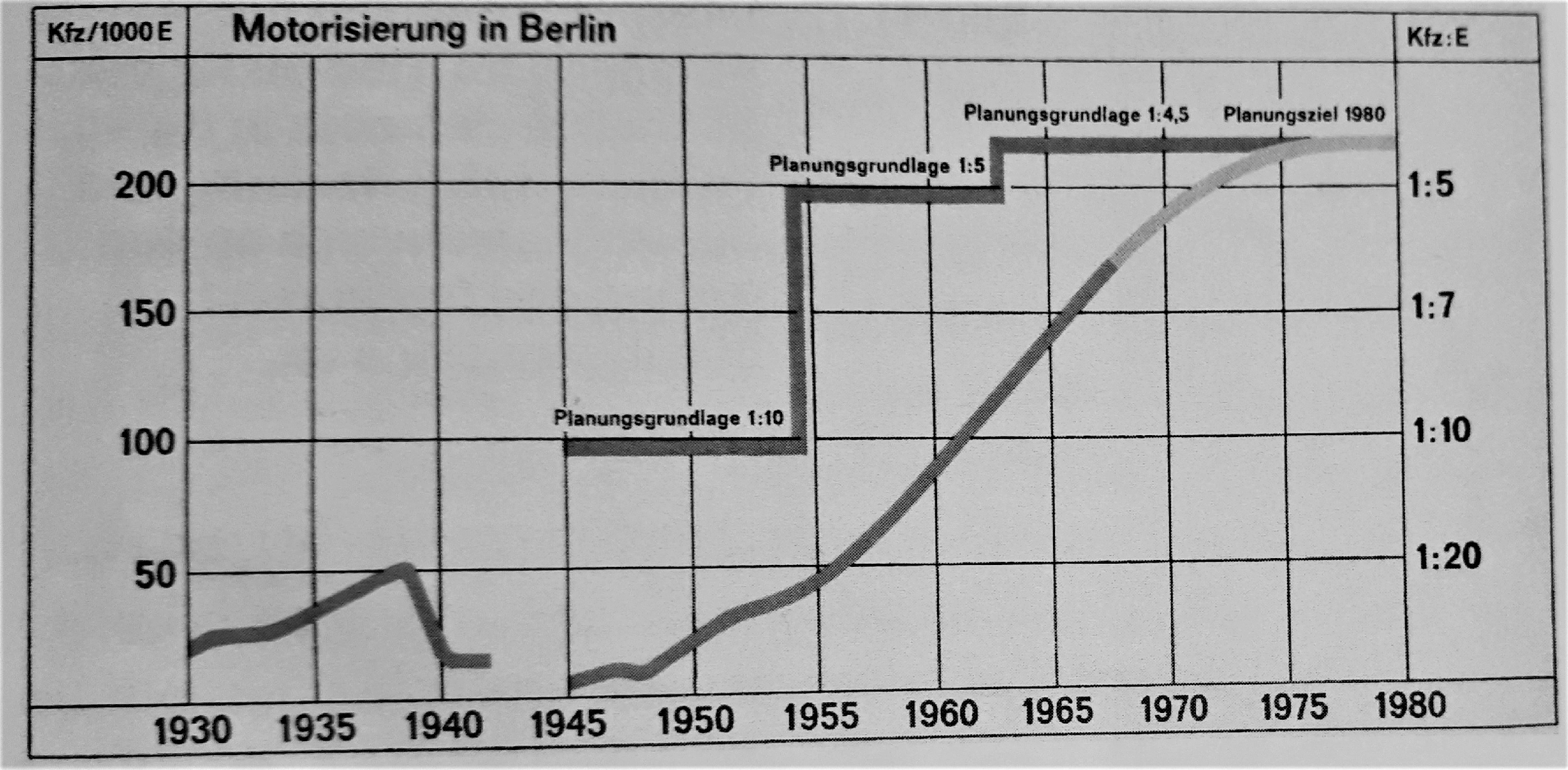
Motorisation in Berlin, 1945–1968: planning assumptions and empirical numbers.
The Berlin Stadtautobahn – Developing a motorway for the cold war city
In the context of the emerging Cold War from around 1950 onwards both parts of the City became showcases of the competing political systems of socialism and Western capitalism. While both urban governments launched large public programs for housing to prevent the serious crises on the housing markets only the Eastern socialist party SED strongly presented the political field of housing and especially the large project of Stalinallee as flagships in their propaganda for the superiority of the socialist system. 26 In contrast the West-Berlin social democrat government moved their priorities in politics and public propaganda from the housing sector, which had been top ranked in their 1920s campaigns, to urban automobility and the project of the urban motorway “Stadtautobahn”. Automobility seemed to better symbolize the modern Post-War Western consumer society and lifestyle and demarcate the gap between the two systems.
In this period the West-Berlin building director Rudolf Schwedler as in-fact successor of Martin Wagner became the key figure in the Senat department for Housing and Construction and the system builder of Berlin as a car-friendly city. After a study trip to the USA in 1953/1954 he gave an order to the Senat's town planning department to elaborate a project for a motorway network. The basic idea was not to design a new plan from scratch but to put together and amalgamate the existing concepts from the pre-war period and the Land use Plan from 1950. The time limit was narrow, as short-term money was available from the West-German government's first funding scheme for the reconstruction of West-Berlin which had to be quickly invested. As a consequence the Senat's ground-breaking decision from 4 July 1955 for the construction of the Stadtautobahn was made without a comprehensive planning for the West-Berlin transport system as a whole, as contemporary critics argued. 27
The key concept of the 1955 decision was to construct a motorway as a ring-road along the circular line of the S-Bahn. In previous general plans for the whole city the ring-road had been conceptualized as part of a larger network which should comprise four tangential sections around the inner city and have a length of about 200 km. 28 The S-Bahn area seemed to provide the best – if not the only – available reserve of land that was needed for such a large scale ring-road. With regard to the division of the city and the ideological bias of the project the Senat's decision concentrated on the Western part of the ring which should be connected to the old AVUS motorway west of Charlottenburg and comprise a system of secondary roads as well as four major crossing points (see Figure 2). The construction was very rapidly started at 1 April 1957 so that the first access ramp at Halensee near the Western end of Kurfürstendamm could be presented to a large public in the context of the large International building exhibition of 1957 (Figure 3). 29
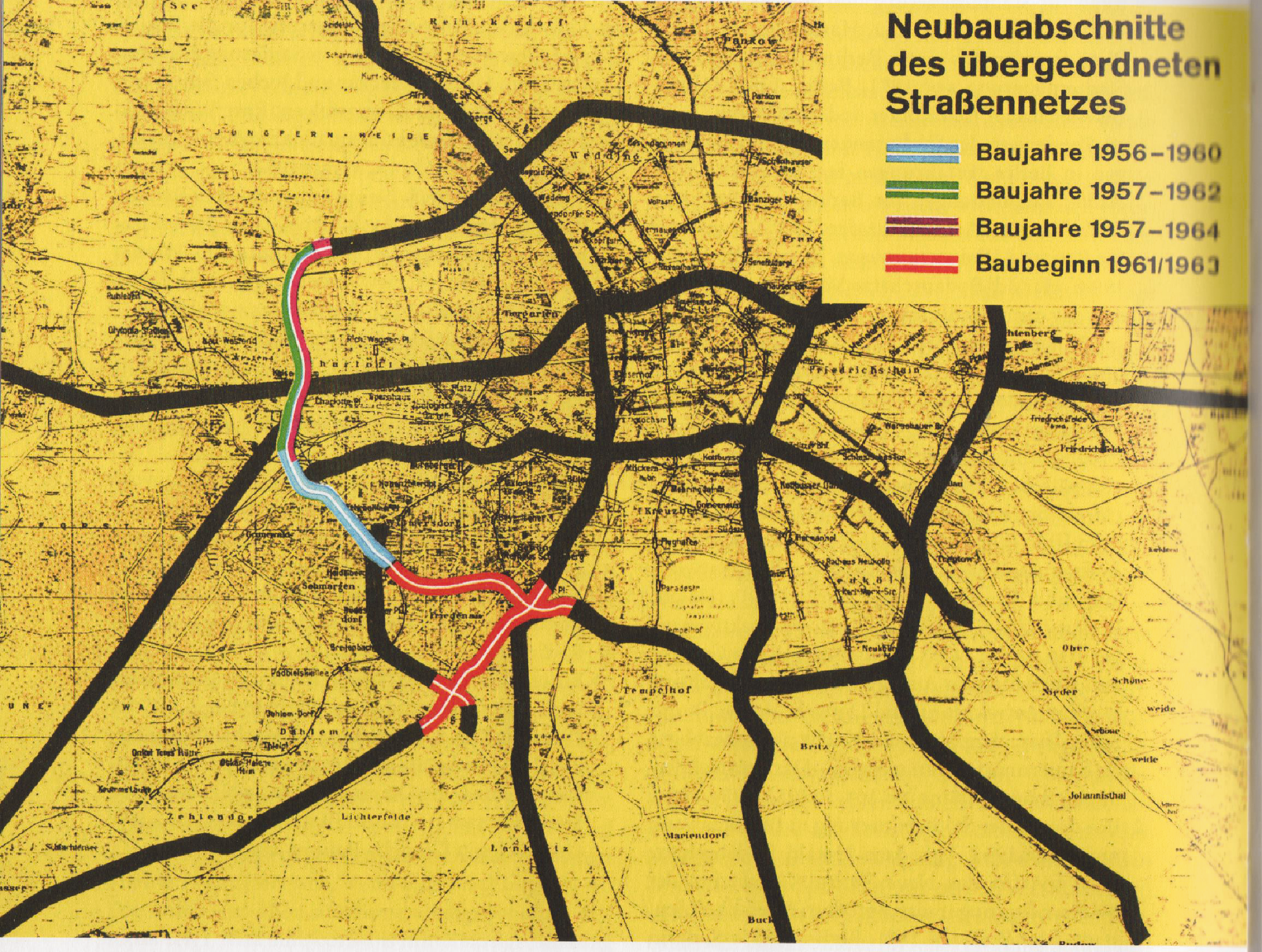
Plan of Stadtautobahn Berlin, 1962. Courtesy of Berlin Senate.
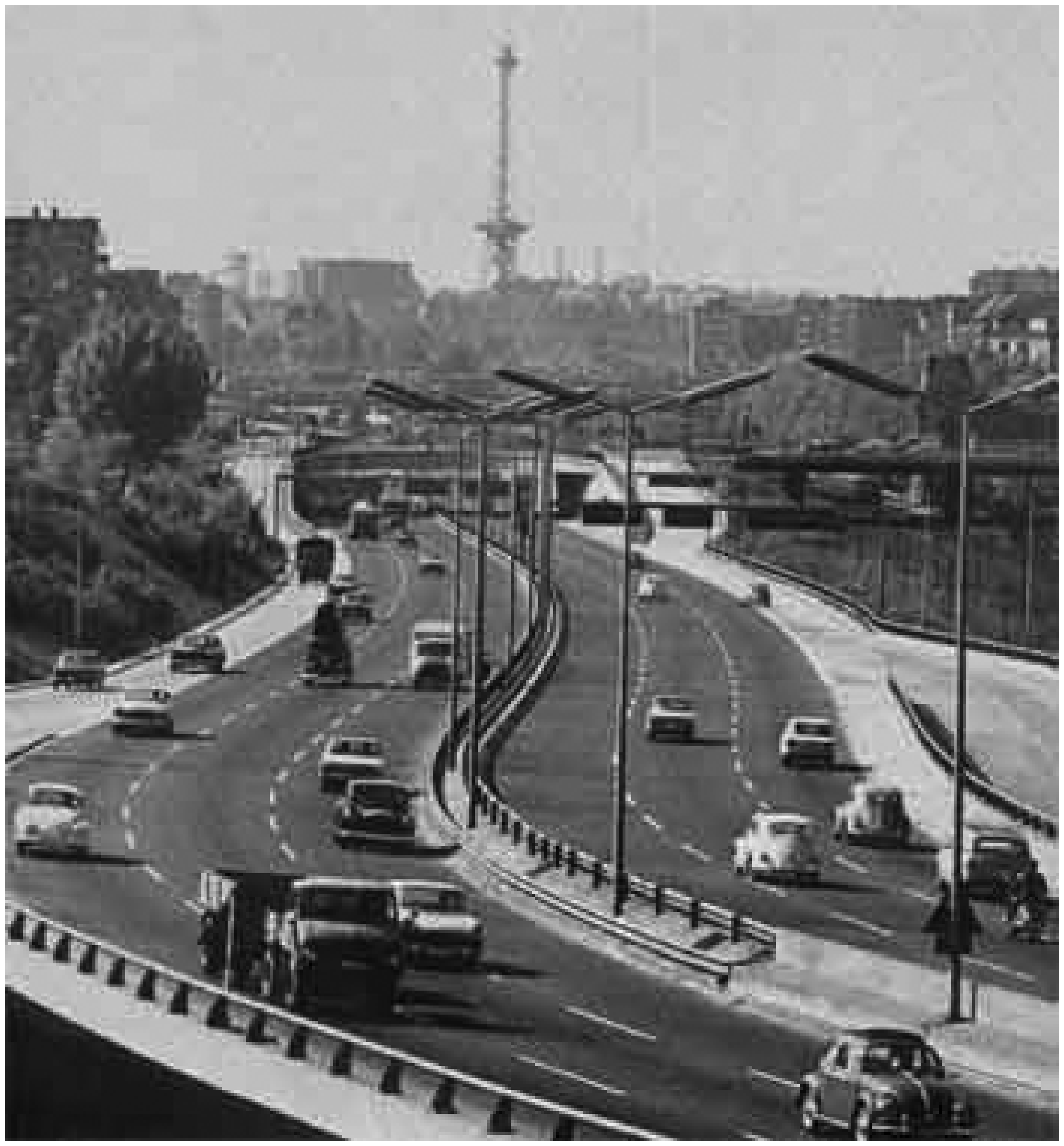
Stadtautobahn Berlin, access ramp Halensee, 1960.
In the course of detailed planning and ongoing construction seven high ranked West Berlin officials from the Senate for Building and Housing undertook from 4 November to 16 December 1957 a six weeks study trip to US-American urban highways which was financed by the USA authorities (while their American colleagues had examined the German interstate highways in the immediate post-war period). The Berlin experts systematically studied the highways of Boston, Detroit and Los Angeles and brought with them a large body of material and a strong enthusiasm to develop a similar system in Berlin. 30 In the early 1950s a large number of German and West European planners and city councillors followed such invitations or took part in training programs at USA universities, as Schmucki and Lundgren have shown. 31 Nevertheless the idea of a linear import of US-American concepts to Europe would be too one-dimensional. In their on-site inspections and evaluations the Berlin experts realized that in contrast to American concepts and with regard to the densely populated and compact urban fabric of Berlin, the important role of public transport and for other reasons the Berlin highways should have another design than those in the USA. 32 Here two versions of the “car friendly city” on both sides of the Atlantic become visible, in which most of the German and the European planners favoured smaller motorways than those in American cities and tangential expressways around the inner city. 33 Christopher Kopper's dictum that the ‘Los Angelization’ of German Cities did not happen” is also true for West-Berlin. 34 Hard/Misás observation of a transnational circulation of visions and concept in architecture and technology that were appropriated, adapted and modified on the national and the local scale, 35 strongly corresponds to the construction of European motorways in general and especially to the case of “Stadtautobahn”.
The first sections of the new motorway were completed within a remarkable short period of time what was made possible by the smart interaction of the town planning and the engineering units of the Senat (see below): in November 1958 the first two kilometres between Halensee and Hohenzollerdamm were inaugurated as a six lane “splendid avenue” (“Prachtstraße”), as the journal “Spiegel” called it. It's official name was “ring-road Berlin of the federal motorway network” which adequately expressed the decisive role of the financial support of the West-German Government. 36 In 1960 the extension eastwards to Mecklenburgische Strasse followed, and 1962/1964 the sections between Halenseestrasse and Jakob-Kaiser-Platz in the West. Despite the difference to American highways underlined above a certain architectural relationship of some few sections of the Berlin “Stadtautobahn” to the New York highways has been observed. 37 In a more general sense the design of the motorway and the ambitious architecture of a number of major buildings and urban places along the new ring-road were composed to a new aesthetical program in which the flows of automobiles were deliberately staged and a new “view on the street” following a drivers perspective was developed, as Seehausen states. 38 A number of major junctions, like Schildhornstraße in the southern district of Steglitz, were embedded in sophisticated spatial arrangements with newly built metro stations and shopping areas. As a result, the motorway worked as a key component of the West-Berlin model of modern lifestyle which from the 1960s onwards was successfully presented to the world and especially to the Eastern socialist neighbours, demonstrating the attractivity and viability of the walled in city. 39
Rearranging the balances of power within the municipal administration of Post-WWII West-Berlin
The planning and construction of the “Stadtautobahn” was made under a social-democratic municipal government which had returned to power after WW II and would direct the city for more than three decades, only ending with the Christian-democratic party's victory in the 1982 elections. During most of this social-democratic era Rolf Schwedler directed the “department for Building and housing” as a Senator (“Senator für Bau- und Wohnungswesen”), a position that he acquired in 1955 and held until 1972. In contrast to Berlins administrative organisation in the Weimar Republic period Schwedler's department integrated the branches of building construction and street planning, thereby realizing Martin Wagners dream of a powerful comprehensive government for the whole sector of spatial planning, engineering and construction. Schwedler explicitly argued that this institutional fusion in Berlin was unique for German cities: “From our West-German colleagues we often hear that urban planners are lining up against underground engineers, and vice versa!” 40 Consequently in the planning of the West-Berlin Stadtautobahn the building director for town planning Friedrich Fürlinger and the building director for transport Werner Leiphold had to closely and conflictual cooperate. For the domains of public transport companies and traffic law a separate administration continued to exist which perpetuated the Reuter public transport branch of the 1920s.
The institutional fusion of the Berlin Senat authorities which brought together urban planners and underground engineers in one municipal authority did not prevent strong conflicts between the two factions of experts from different disciplinary backgrounds. In the middle of the 1950s these contradictions condensed in two competing concepts for the southern part of the “Stadtautobahn”. The urban planners wanted to build on ideas from 1929 for a “Stadtring” (ring-road) which had been incorporated in the official land use plan of 1950 while the engineers favoured a line which was further to the south and was based on Albert Speers general plan from 1939. The conflict ended in a special type of compromise: Schwedler decided that the urban planner's southern “Stadtring” project should be realized but the underground engineers department became responsible for the executive construction. 41 The latter professional faction expanded their competences in the following decades while the urban planners resigned from the “Stadtautobahn” project. From the 1970s onwards they started to strongly criticize urban motorways in general.
The whole project would not have been possible without the financing by the West-German Federal government. Throughout the Cold War period the West-Berlin public budget was financed by 40 per cent or more from the West-German government. The “Stadtautobahn” and related projects were corner stones of a “symbolic financial policy”, as Zschaler and others have called this engagement. 42 In terms of administrative procedures, ressources and responsibilities the category of “Bundesfernstraßen” (federal highways”) in which “Autobahnen” are listed, was since the early Post- WWII period and until today the key category for financing and building large scale motorways in Germany with the help of federal public funding. 43 Consequently the West-German Federal state funded the “federal highways” from 1950 to 1958 with 4,7 billion Mark and massively increased its engagement by starting a series of three four-year- plans which in 1971 was followed by the first five-years plan. In this huge campaign of a fordist state driven program for a national motorway network the yearly budget for construction was increased from 1,5 billion Mark (1959) 44 to 5,1 billion Mark in 1970. 45 The huge costs for this type of infrastructure were also reflected in the budgets for the Berlin Stadtautobahn: Two relatively small sections of the motorway of 4 respectively 3,3 km length were calculated in the 1973 plan of the Federal Ministry of Transport with 375 Mil. Marks. In addition in the same year a tunnel section from the Stadtautobahn to the West Berlin Airport in Tegel with a length of around 1,4 km was under construction which was calculated with 42,8 Mil. Mark. This system of financing the motorways by federal money was and still is the major financial driving force for the rapid expansion of the network of motorways. Within this logic German “Länder” (states) were and still are strongly competing for a maximum of federal transfer money in order to construct and extend their road infrastructures, while they themselves had and have to provide the staff for the management and maintenance of the networks. 46
The integration of West-Berlin in West German financial policies and infrastructural networks marked in fact a strong discrepancy to the nearly ex-territorial legal status of the city which was governed by the four Allies. The official declaration which forced the two federal ministries of transport and of finances to permanently maintain the Stadtautobahn with high costs was made after internal struggles in 1962. When in 1974 the German ministry for transport decided to classify German federal motorways, the Berlin Stadtautobahn was labelled national motorway A 10 (“Bundesautobahn A 10”). 47
The turning point of the mid-1970s
Since the early 1960 a growing critical public debate on the negative effects of the “automobile city” emerged which in Germany was triggered by intellectuals like Bahrdt, Salin, Mitscherlich and denounced the decline of urbanity in West European cities. In France it was Alfred Sauvy who in 1968 contributed with a book entitled “Les quatre roues de la fortune” (The Four Wheels of Fortune) a “veritable anti-automobile pamphlet” (Dupuy). With regard to the rapidly growing number of cars Sauvy predicted the destruction of Paris by the automobiles and the public space that cars required. 48 Colin Buchanan in his famous report “Traffic in towns” from 1963 tried to take up environmental concerns into new concepts for urban automobility and infrastructure. 49 In Switzerland in the context of an environmental turn from 1970 onwards urban citizens increasingly resisted to new automobile infrastructural projects, as Haefeli has shown. 50
Parallel to these discourses throughout Europe from around 1970 onwards in West-Berlin also the general political context and the mode of governance substantially changed. The Quadripartite Agreement of 1971/72 among the four allied governments and the intra-German appointments on the regularization of transit between West Berlin and the Federal Republic set better conditions for travels from and to West-Berlin and reduced the isolation of the city. 51
In this context of increasing public critique and the consolidated political status of a divided city the idea of a comprehensive network of motorways in the heart of the metropolitan region and across the wall was not any more realistic. The costly West-Berlin parts of the ring-road that had been realized stayed fragmentary, as after the construction of the wall in 1961 and the treaties of the early 70 s the previous concepts for a comprehensive “Stadtautobahn” across the borders and for the whole region were suspended. Moreover, a growing oppositional movement grew up which contested the key component of “Westtangente”. Citizens initiatives, like the “Bürgerinitiative Westtangente”, played a decisive role for the turn in the public opinion against the automobile city, as the article of Harald Engler in this volume shows in detail. Not at least a growing shortage in the public budgets resulting from the economic decline paved the way for a fundamental re-orientation of West-Berlin transport policies. 52
As a result in the middle of the 1970s the vision of a “car friendly city” in Berlin's public debate and administration was abandoned and the old planning was step by step suspended. This process which went hand in hand with the emergence of new concepts for urban renewal was only gradually implemented in official plans. The turn was institutionally initiated by a ground-breaking internal shift within the municipal branch of the Senate for Building and Housing which was hardly visible for the public. Around 1975 then West-Berlin Senator for Building Construction and Town Planning, Harry Ristock, decided to reorganize his administration and implemented a small working group which should study alternatives to the concept of the car friendly city. 53 One of his collaborators was Hans Stimmann, later building director of unified Berlin. In his analysis of West Berlin motorways prepared by his PhD he showed why and how sophisticated concepts for traffic and housing along the “Stadtautobahn” had failed. 54 As a result Senator Ristock in 1976 presented a new concept in which the major part of the tangential motorways was suspended, while the “West-Tangente” was still maintained (Figure 4). 55 But even if in the official documents the old visions of the car friendly city were downgraded on the scale of urban design the new paradigm only found unanimous support from urban planners. Transport engineers, in contrast, continued to promote the construction of motorways until today, as can be seen along the case of “motorway A 100” which in the Eastern part of Berlin is actually still under construction.
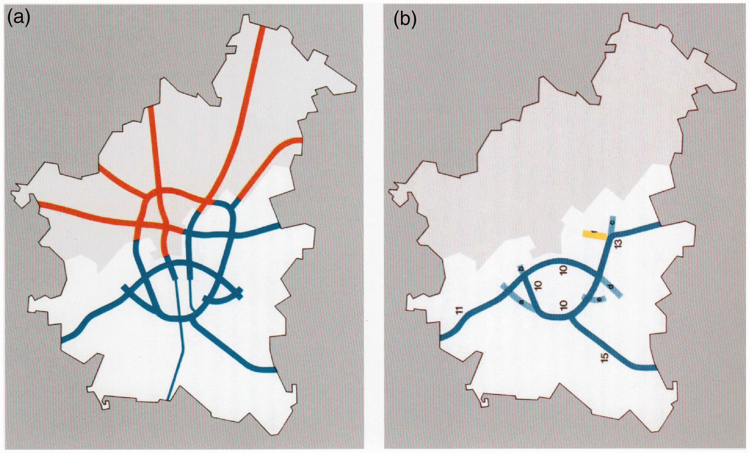
Plan for the Berlin Stadtautobahn (a) 1968, (b) 1976. Courtesy of Berlin Senate.
A transnational view on inner-urban motorways in the post WWII-era
On the national scale the municipal administrations of Hannover, Munich, Duesseldorf and some other West-German cities were sharing the contemporary enthusiasm for this type of automobile infrastructure and showed similar ambitions to launch urban highways as West-Berlin. 56 Hannover under the regime of city councillor for building Rolf Hillebrecht became the role model of a car-friendly city. But the urban motorways in Hannover, Munich and Duesseldorf differed in several ways from the Berlin ring-road in terms of architecture, street classification (most of them were ranked “national roads”/”Bundesstraßen”) and size. 57
Also on the European and global scale projects for urban motorways became a key issue at conferences and in journals. A large international conference held in London in 1956 on “Urban motorways” discussed problems of traffic congestions in inner cities, as did in the following year the 13th International Congress of the International Association of municipal authorities. 58 The German motorway lobby was closely cooperating with international networks in many ways. In his report from 1973 the West German Federal Ministry for Transport proudly informed the parliament (Bundestag), that he had strongly supported the VII World Congress of the International Road Federation (IRF) held from 15 to 20 October 1973 in Munich. Close multinational cooperation was also practiced in a Group for Road Research (“Straßenforschungsgruppe”) of the OECD, and bilateral cooperation with the French Ministère de l'Equipement et du Logement et du Tourisme was practiced in joint research and work programs. 59
In a wider cross-European perspective the Berlin pathway to the car-friendly city shows some specific parallels and differences to similar projects in other European cities. A short evaluation of some other inner ring-roads and motorways constructed in the Post-WWII period in Paris, Rome and British cities along the criteria of time logics and urban governance allows to deepen the reflection on the specific profile of the Berlin project.
As a first general observation we can state that in most of the European cities the pressure of mass-motorisation and congestion was a powerful trigger for the planning of urban motorways which marks a clear contrast to the Berlin situation. Flonneau reports for the Paris case that the number of cars in the French capital grew from 1950: 82,000 to 1980: 799,000 by nearly 10 times. 60 In a contrasting perspective with Paris the de-facto stagnation and unique situation of West-Berlin in the Post WWII period becomes very evident. The French capital underwent in the period of the economic boom (“trentes glorieuses”) after 1945 a process of strong demographic growth, tertiarization of the inner-urban districts, industrial decentralisation and residential suburbanisation. 61 But long before that boom, as early as in the interwar period, urban transport and mobility already had developed a constantly growing pressure at the periphery of the French capital (which represents the inner area of the metropolitan region) and especially along its major gates. 62 The first idea to construct a ringroad to replace the fortification was made public as early as in 1925 by Louis Baudry de Saunier, and in the following years a large number of projects was presented and partly realized to reform the octroi and rebuild the areas at the main gates.
The decision to build the first part of the motorway between the ports of la Plaine and Ivry was made at 23 December 1954. At that time the planning authorities estimated that it would take about 30 years to complete the ring-road which was – in contrast to West-Berlin – financed half-half by the state and the city of Paris. 63 Even if the new “boulevard” showed features of a motorway it was primarily conceived along a concept of a large road at the periphery of Paris. 64
The most important “critical decision” which paved the way for the automobile transformation of Paris was only made in 1960. In this year the new institutional body of ‘District de la region parisienne’ (District of the Paris Region) was created in order to develop the regional ‘Plan d’Aménagement et d’Organisation Générale de la Région Parisienne’ (PADOG). The new organisation published in 1963 a “white paper” for the Paris region which included the concept for the boulevard peripherique. It was the pioneering figure of Paul Delouvrier, the General Delegate of the District and eminent urban planner, together with his colleagues successfully who transformed the city in favour of the automobile in the larger context of the economic miracle of “The trentes glorieuses”. 65
It was the opening of the right banks expressway by state president Pompidou on 22 December 1965 and the inauguration of the whole boulevard at 25 April 1973 by Prime Minister Pierre Messmer that completed the glorious decade of automobile transformation of Paris, as one might say. In his inauguration talk Messmer proudly evoked the numbers of 160,000 to 200,000 cars that passed at certain sections of the motorway and highlighted the character of the work as another “grand oeuvre” in the magnificent history of Paris. 66 In the early 2000s
Paris “perif” took up about 35–40 per cent of the Paris automobile traffic. At that time about 1,1 Mil. cars with 1,3 Mil. Passengers (around a third of the 3,6 Mil. daily passengers of the underground Metro) passed the “perif”. 67 Since around 1980 in the context of an “anti-noise program” (programme general de protection contre les nuisances sonores”) launched in 1982 a large number of noise protection barriers was constructed along the “perif”. In the following two decades critical public debates on the ring-road undermined the “tabou of the automobile infrastructure” while on the other hand questions of architectural qualities and heritagisation won of interest. 68 Recently a public debate emerged in which a re-designing and even closure of some parts of the “peripherique” were discussed. 69
The Italian project of the Rome ring-road called “Gra” was probably the earliest ring-road in a major European city in the Post WWII period. The first idea of what later became the plan for the new “Autostrada del Grande Raccordo Anulare) (GRA), today “autostrada A90” with a length of 68,2 km, took up and modified an idea of the urban development plan from 1931. 70 It was as early as in 1946 that the Ministry for public works under the presidency of the General director Eugenio Gra launched the project for the first section of the new motorway which was meant to connect Via Appia and Via Aurelia. The main goal was to redirect long-distance traffic from north to south Italy and keep it away from the city centre in a distance of about 11 kilometers. This idea marked a clear difference to the Berlin, Paris and most of the British projects which gave priority to the needs of the local transport. In Rome the decision of the state in a situation where post-fascist institutional balances and competences had not been stabilized meant a de-facto exclusion of local authorities of this major project. It was for some years intensively discussed and modified, and finally the Italian parliament approved the construction of the new ringroad in May 1955. 71
British cities like London, Leeds, Liverpool, Birmingham, and Glasgow also developed a large number of different types of ring-roads since the late 1950s, as Simon Gunn has shown. Here, technocratic strategies of governing the exploding number of cars in urban streets in the context of mass motorisation met with more general ideas of urban governance and planning with regard to slum clearance and urban envirommental policies. 72
In Birmingham motorways were rapidly developed in the course of the 1960s as a system of inner ring-road, flyovers, tunnels, interchanges and arterial roads, connecting the urban network to the national motorways. When it was completed in 1972 the system represented “the largest free-flowing roads interchange in Europe”. 73 In an inner-Britain comparative perspective Glasgow's concept, which was also completed in the early 1970s, was quite ambitious. As Sarah Mass has shown, the concept developed in the 1960s proposed no less than 75 miles of motorways, nearly as double as much as the 39 miles that were planned for London. Glasgow obviously represents, as Berlin, a case of a prospective planning that was ahead of the actual needs of urban automobility: in the early 1970s in Glasgow only 113 cars per 1,000 inhabitants were counted which was less than half of the British national average. 74
Conclusion
This article intended to explore the history of Berlin’s pathway to the automotive city with a special focus on the inner-urban ringroad “Stadtautobahn” and reflect its key features from a transnational comparative perspective. Three main insights can be drawn from the analysis undertaken here: From the 1920s and the visionary urban councillor Martin Wagner Berlin's pathway was characterized by a prospective, even utopian thinking. Being a late-comer in urban automobility – a role that was strongly consolidated during the Cold War – did not hamper Berlin to become a forerunner in the construction of urban motorways. As a result, the “Stadtautobahn”, together with the Rome “Gra” motorway counted amongst the first large ring-roads in European cities. In contrast to British and French cities, where planning mainly reacted on contemporary problems, in Berlin future needs of automobility were anticipated and translated into large concepts which were far ahead of contemporary demand. From the 1950s onwards the strong societal consensus in Western and most of the Eastern countries that automobility was a key symbol of modernity was even reinforced in West-Berlin in the context of the Cold-War-antagonism. Schmuckı's argument, that a spirit of modernity and ideas of modern aesthetics and urbanity strongly triggered urban motorways in Germany and the US 75 is certainly also true for Berlin; but it has to be expanded by integrating the logics of Cold War political antagonism in which western lifestyle served as a symbol of superior productivity and legitimacy of the capitalist system.
Inner-administrative struggles, especially between the departments of urban design and underground engineering, were identified along the Berlin case as the centre field of a socio-history of power in urban transport policies. These antagonisms were perpetuated throughout the twentieth century and shaped the Berlin pathway. In the Post-WWII period, the faction of engineering became dominant for around two decades, and the construction of the Berlin motorways was financed by the huge subsidies of the West-German Government. The paradigmatic shift of the 1970s which hampered and in the long run stopped the concept of the car-friendly city seems to have been more radical than in many other European cities. The transformation from the Cold War patterns of hostile competition to smoother forms of conflict together with a serious financial crisis and strong citizens movements undermined the concept. Despite its role as a fore-runner, the Berlin motorway network remained incomplete and urban automobility in the German capital stays relatively week until today.
Footnotes
Declaration of conflicting interests
The author(s) declared no potential conflicts of interest with respect to the research, authorship, and/or publication of this article.
Funding
The author(s) disclosed receipt of the following financial support for the research, authorship, and/or publication of this article: The research for this article was financed by Leibniz-Institute for Research on Society and Space (IRS), Erkner/Germany.
1
Gijs Mom, Atlantic Automobilism. Emergence and Persistence of the Car, 1895–1940 (New York: Berghahn, 2015); Christopher Kopper and Massimo Moraglio (eds), The Organization of Transport. A History of Users, Industry, and Public Policy (New York: Routledge, 2015); Simon Gunn and Susan C. Townsend, Automobility and the City in Twentieth Century Britain and Japan (London: Bloomsbury, 2019).
2
Brian Ladd, Autophobia. Love and Hate in the Automotive Age (Chicago IL: University of Chicago Press, 2008); Christopher Klemek, The Transatlantic Collapse of Urban Renewal: Postwar Urbanism from New York to Berlin (Chicago IL: University of Chicago Press, 2011).
3
See the Special Issue “Austro-German transport histories”, The Journal of Transport History 34 (2013); Per Lundin, “Mediators of Modernity: Planning Experts and the Making of the “Car-Friendly“City in Europe”, in Mikael Hård and Thomas J. Misa (eds), Urban Machinery. Inside Modern European Cities (Cambridge, Massachusetts: MIT Press, 2008), 257–80; Mathieu Flonneau, “Myth and Realities of ‘Americanization’ in transport history: The construction of car dependence in the Paris region after World War I”, in Informationen zur Modernen Stadtgeschichte 2/2006, 28–42; Graeme Davison, Car wars: How the car won our hearts and conquered our city (London: Allen & Unwin, 2004).[AQ: Please provide page range, editor name(s) and publisher–location in footnote 3.]
4
Lewis H. Siegelbaum (ed.), The Socialist Car. Automobility in the Eastern Bloc (Ithaca NY, London: Cornell University Press, 2011).
5
Ueli Haefeli, Verkehrspolitik und urbane Mobilität. Deutsche und Schweizer Städte im Vergleich 1950–1990 (Stuttgart: Franz Steiner, 2008); Gunn and Townsend, Automobility and the City..
6
David A. Barclay, “A ‘Complicated Contrivance’. West Berlin behind the Wall, 1971–1989”, in Marc Silberman, Karen E. Till and Janet Ward (eds), Walls, Bounders, Boundaries. Spatial and Cultural Practices in Europe (New York NY: Berghahn, 2012), 113–30, here 114.
7
See for the conceptual approach of a socio-histoire of power: Jay Rowell, “Socio-Histoire der Herrschaft”, in Sandrine Kott and Emmanuel Droit (eds), Die ostdeutsche Gesellschaft. Eine Transnationale Perspektive (Berlin: Ch. Links, 2006), 26–34; Bénédicte Zimmermann: “Socio-histoire and public policy rescaling issues: Learning from unemployment policies in Germany (1870-1927)”, in Stefanie Börner and Monika Eigmüller (eds), European Integration, Processes of Change and the National Experience (London: Palgrave Macmillan, 2015), 121–46.
8
See Akademie der Künste Berlin, Martin Wagner 1885-1957. Wohnungsbau und Weltstadtplanung. Die Rationalisierung des Glücks (Berlin: Akademie der Künste, 1986).
9
See Christoph Bernhardt, “Längst beerdigt und doch quicklebendig. Zur widersprüchlichen Geschichte der ‘autogerechten Stadt’”, Zeithistorische Forschungen/Studies in contemporary history 14 (2017), 526–40.
10
See Martin Wagner, “Das Berliner Wohnungsproblem. Ein Interview”, in Martin Wagner and Adolf Behne (eds), Das Neue Berlin. Großstadtprobleme (Berlin: Deutsche Bauzeitung, 1929), 50–7.
11
Martin Wagner, “Das neue Berlin – die Weltstadt Berlin”, in Martin Wagner and Adolf Behne (eds), Das Neue Berlin. Großstadtprobleme (Berlin: Deutsche Bauzeitung, 1929), 4–5.
12
Heinz Reif and Moritz Feichtinger (eds), Ernst Reuter. Kommunalpolitiker und Gesellschaftsreformer (Bonn: Verlag J.H.W. Dietz Nachf., 2009).
13
Ural Kalender, Die Geschichte der Verkehrsplanung Berlins (Köln: Forschungsgesellschaft für Straßen- und Verkehrswesen e.V., 2012).
14
Barbara Schmucki, “Schneisen durch die Stadt – Sinnbild der ‘modernen Stadt’. Stadtautobahnen und amerikanisches Vorbild in Ost- und Westdeutschland, 1925–1975”, in Werkstatt Geschichte 21:1998, 43–64, here 46.
15
Kalender, Die Geschichte, 252–254. See also Michael Kriest: “Reichsautobahnen und Stadtplanung”, in Moderne Stadtgeschichte 2 (2017), 133–152; Christopher Kopper, “Germany’s National Socialist transport policy and the claim for modernity: reality or fake?”, The Journal of Transport History 34 (2013), 162–76; Thomas Zeller, Driving Germany. The Landscape of the German Autobahn, 1930–1970 (Oxford: Berghan, 2007).
16
Kalender, Die Geschichte, 248–262.
17
For a more detailed survey on urban planning in devided Berlin 1945-89 see Christoph Bernhardt, “Planung für den Großraum in der Zeit der Teilung (1945–89)”, in Harald Bodenschatz, Harald Kegler (eds), Planungskultur Groß-Berlin (Berlin: Lukas, 2020), 120–43.
18
19
For statistical data on private motorisation in several Western countries throughout the 20th century see Schmucki, “Schneisen”, 44.
20
Udo Dittfurth, “Verkehrsplanung in West-Berlin. Ein Bericht aus dem ideologischen Sektor”, in Günther Schlusche et al. (eds), Stadtentwicklung im doppelten Berlin. Zeitgenossenschaften und Erinnerungsorte (Berlin: Ch. Links, 2014), 226–41, here 228.
21
Kalender, Die Geschichte, 368.
22
Johann Friedrich Geist and Klaus Kürvers, Das Berliner Mietshaus 1945–1989 (München: Prestel, 1989), 180–218.
23
Bernhardt, “Planung”.
24
Kalender, Die Geschichte, 369.
25
Martin Wagner, “Ein offener Brief”, Neue Bauwelt 7 (1948), 99.
26
Helmut Engel and Wolfgang Ribbe (eds), Karl-Marx-Alle – Magistrale in Berlin – Die Wandlung der sozialistischen Prachtstraße zur Hauptstraße des Berliner Ostens (Berlin: Akademie-Verlag, 1996); Geist and Kürvers, Das Berliner Mietshaus, 337–54.
27
Kalender, Die Geschichte, 368–69.
28
Harald Bodenschatz et al., “Wiederaufbau, zweite Zerstörung, neue Tendenzen”, in Josef Paul Kleihues, 750 Jahre Architektur und Städtebau in Berlin. Die Internationale Bauausstellung im Kontext der Baugeschichte Berlins (Berlin: Internationale Bauausstellung, 1987), 213–42, here 225.
29
Frank Seehausen, “Schwungvoll in die Zukunft. Die Inszenierung des fließenden Verkehrs im Berlin der 1960er Jahre”, in Thomas Köhler and Ursula Müller (eds), Radikal Modern. Planen und Bauen im Berlin der 1960er Jahre (Tübingen and Berlin: Ernst Wasmuth, 2015), 114–23, here 115.
30
Ibid., 117.
31
Schmucki, “Schneisen”, 50; Lundin, “Mediators”.
32
Dreispurig durch Berlin, in Der Spiegel 14 January 1959, 46–47.
33
See in detail my reflections on this transatlantic split along the case of Bernhard Reichow and the German debate in Bernhardt, “Längst beerdigt”, 532–34.
34
Christopher Kopper, “Why the ‘Los Angelization’ of German Cities Did Not Happen: The German Perception of U.S. Traffic Planning and the Preservation of the German City”, in Christopher Kopper and Massimo Moraglio (eds), The Organization of Transport. A History of Users, Industry, and Public Policy (New York NY: Routledge, 2015), 106–17.
35
Mikael Hård and Thomas J. Misa (eds), Urban Machinery.
36
Der Spiegel, 14 January 1959, 46.
37
Seehausen, “Schwungvoll”, 117, highlights the similar architectural design of the Berlin Stadtautobahn-AVUS junction and the New York Grand Central Parkway.
38
Ibid.
39
Ibid.
40
Kalender, Die Geschichte, 370.
41
Ibid.
42
Frank E.W. Zschaler, “Bundeshilfen für Berlin”, in Michael C. Bienert, Uwe Schaper and Hermann Wentker (eds), Hauptstadtanspruch und symbolische Politik. Die Bundespräsenz im geteilten Berlin 1949–1990 (Berlin: be.bra wissenschaft, 2012), 209–20, here 215–19.
43
Der Präsident des Bundesrechnungshofes (ed.), Bundesfernstraßen. Planen, Bauen, Betreiben (Stuttgart: Kohlhammer, 2004), 1–4.
44
45
46
Der Präsident des Bundesrechnungshofes (ed.), Bundesfernstraßen, 3–4.
47
Kalender, Die Geschichte, 374–75.
48
Gabriel Dupuy, “The automobile system: a territorial adapter”, in Flux 21 (1995), 21–36.
49
Simon Gunn, “Ring-Road: Birmingham and the Collapse of the Motor City Ideal in 1970s Britain”, in The Historical Journal 1 (2018), 227–48, here 235.
50
Haefeli, Verkehrspolitik und urbane Mobilität, 49–52.
51
Barclay, “A ‘complicated contrivance’”, 114.
52
Harald Bodenschatz et al. (eds), Wiederaufbau, 225–29.
53
Interview of the author with Hans Stimmann, 17 May 2018.
54
See Hans Stimmann, Verkehrsflächenüberbauung. Analyse und Kritik einer städtebaulichen Konzeption und ihrer Anwendungsversuche im Rahmen städtebaulicher Umnutzungsprozesse West-Berlins (PhD TU Berlin, 1980).
55
Hans Stimmann, “Städtebau vom Europäischen Jahr des Denkmalschutzes bis heute, 1975-2010”, in Harald Bodenschatz, Jörn Düwel, Niels Gutschow, et al. (eds), Berlin und seine Bauten, Teil I – Städtebau (Berlin: Dom Publishers, 2009), 357–456, here 358.
56
Schmucki, “Schneisen”, 50.
57
Der Spiegel, Hillebrecht. Das Wunder von Hannover, 23/1959, 56–69. Barbara Schmucki, Der Traum vom Verkehrsfluß. Städtische Verkehrsplanung seit 1945 im deutsch-deutschen Vergleich (Frankfurt a. M.: Campus, 2001).
58
Schmucki, “Schneisen”, 51.
59
60
Mathieu Flonneau, Paris et l'automobile. Un siècle de passions (Paris: Hachette Literature, 2005), 150.
61
Jean Lojkine, La politique urbaine dans la region parisienne 1945–1971 (Paris: Mouton, 1973), 17.
62
Matthieu Flonneau: L'automobile à la conquête de Paris: chroniques illustrées, Paris : École Nationale des Ponts et Chaussees, 2003), 217.
63
Ibid., 218.
64
Ibid., 219.
65
Bertrand Lemoine, L'histoire du boulevard périphérique (Paris: Ville de Paris, 2005).
66
Flonneau: L'automobile, 229.
67
Numbers taken from Francois Moriroux, Dossier “Penser à Paris a travers le perif”, D'Architecture 178 (2008), 55.
68
Francois Moriroux, “Une doctrine qui se cherche?”, D’Architecture 178 (2008), 46–50, here 47.
69
See Conseil de Paris, mission d’information et d’évaluation, Rapport Le périphérique, quelles perspectives de changements? (Paris: Conseil de Paris 19 May 2019), ![]() (accessed 15 November 2019).
(accessed 15 November 2019).
70
Piero Ostilio Rossi, Per la Città di Roma. Mario Ridolfi urbanista 1944-1945 (Rome: Quodlibet, 2014), 141.
71
Ibid., 65–7; 147.
72
Gunn, “Ring-road”, 8.
73
Ibid., 5.
74
Sarah Mass, “Cost-benefit break down: unplannable spaces in 1970s Glasgow”, Urban History 2 (2019), 209–30, here 212.
75
Schmucki, “Schneisen2”, 44.