
Abstract
Technological changes have opened up new opportunities for historical research, which call for new methodologies to fully realise these opportunities. This paper presents the four-step interactive photo timeline analysis we developed to analyse large volumes of historical photographs from both a quantitative and qualitative perspective. We present the results of a case study (regarding both street design and street use in Vienna from 1860 to 1949) in which we utilised interactive photo timeline analysis. The geographical research scope was limited to the streets around the Vienna Opera: street use and street design were analysed from the perspective of the street as transportation space and as urban living space. The development of the interactive photo timeline analysis methodology and the case study analysis benefited greatly from the interdisciplinary nature of the research team.
Introduction
While a great deal of literature on city and street life exists, the vast majority of it focuses on cities in the United Kingdom and United States. Works such as Streetlife in Late Victorian London by Peter Andersson and London’s Teeming Streets by James Winter look at how street use in London changed and was contested over time, while The Death and Life of Great American Cities by Jane Jacobs offered the first and most comprehensive critique of urban planning policies in 1950s and 1960s America, thus helping to revolutionise the field. Writers such as Peter Hall expand upon this to look at the history of planning over time and across space, on the basis of different theoretical city concepts illustrated by case studies ranging from London to Brasilia to Chandigarh. 1 Nonetheless, the analysis remains generally Anglo-Americentric.
Groundbreaking works by Peter Norton and John Urry form an important foundation for our research. Although squarely centred on American cities, Norton examines both the social aspects of the street, and how automobiles asserted their dominance in the twentieth century. 2 John Urry similarly takes up the question of social and physical ramifications of travel and different forms of movement, with an emphasis on social transformations generally, rather than street design and use. 3
Among the German-language literature, the approach has been largely theoretical, without an emphasis on photo analysis or a long-term historical viewpoint. Relevant literature includes Ueli Haefeli’s comparative approach to examining transport policy and urban mobility in Germany and Switzerland from 1950 to 1990. 4 Helmut Holzapfel similarly focuses on Germany in his critique of ‘automobility’ and analysis of successful people-oriented planning. 5 Dieter Apel meanwhile takes a broader look across Europe in examining the effect of expanded bus and train lines on automobile usage. 6 Other relevant German-language works by Uwe Altrock and Grischa Bertram 7 and Sylvia Necker and Daniel Bartetzko 8 highlight the importance of governance and questions of ‘modernity’ in city planning, respectively.
Focusing on Vienna, Elisabeth Lichtenberger’s Bridge Between Cultures includes one chapter examining planning and housing in the city center, 9 Carl E. Schorske’s Fin-de-Siecle Vienna: Politics and Culture, dedicates a chapter to the Ringstraße and urban modernism, and Donald Olsen’s comparative study The City as a Work of Art: London, Paris, Vienna examines deliberate urban planning and the enhancement of public life through great building projects in these three cities. On the whole, Vienna has not been studied to the same extent as other cities and the interplay between street use and street design in Vienna over time has been overlooked. Given that Vienna is the second largest city in the German-speaking world, it is remarkable that more attention has not been paid to the evolution of its street use and design. To begin to rectify this imbalance, Vienna serves as an initial small-scale case study through which the authors developed, tested, and refined the interactive photo timeline analysis (IPTA) presented in this paper.
The research presented in this paper is an initial attempt to develop a new methodology using digitisation and an interactive timeline tool to test the methodology by analysing how the streets around the State Opera in Vienna, Austria changed using historical photographs from the period 1860 until 1949. With the use of this tool and through a series of analysis workshops, we endeavour to answer the following research questions: how did the streets around the Vienna State Opera change as an urban living space during this period? How did they change as a transportation space? In trying to answer these research questions, we tested and refined the methodology that we developed. These research questions served as a test bed for the development of the new methodology.
To do this, we utilised historical photographs from the digitised archive of the Austrian National Library to create a database from which data could be pulled. We then programmed a digital interactive tool with timeline and geo-location features to conduct an analysis of the collected photographs. This forms the foundation of the four-step IPTA we developed. 10 This methodology is intended to allow for both a quantitative and qualitative approach in order to mitigate some of the problems inherent in the use of photographs as historical sources.
To test and refine our IPTA methodology, we conducted a case study on the streets around the Vienna State Opera. The area around the Opera was chosen for a number of reasons, most notably for its geographic centrality to Viennese street life, its important location regarding new forms of transportation, and the fact that it is historically well documented. As Alfred von Baldass pointed out in 1929, the portion of the Ringstraße near the Opera belongs to the most visited part of the city, and together with the Kärntnerstraße (which runs along the east side of the Opera), forms the central promenade of Viennese social interaction in the midday and evening hours. 11 Indeed, it was at precisely this intersection of the Ringstraße and Kärntnerstraße that the first traffic light in Vienna was installed in 1926. 12 The Opera was built in 1869 as the first major building along the newly constructed Ringstraße, which itself was opened in 1865 after demolition of the city walls. The area around the Opera therefore plays an important role in Viennese city life, both as a transportation space and as an urban living space. 13 We have developed an interdisciplinary methodology (IPTA) that draws from the fields of transport planning, history, and social sciences to provide a first-step analysis of how this space has changed over time.
Literature on the use of photographs as historic sources is abundant, and the methods developed for and applied to photo analysis are as diverse as the field they serve. 14 However, historic photographs have not yet been fully utilised as sources in the field of urban and/or transport history. In the event that photographs are used in urban studies, such as by Dieter Apel, 15 they are generally used in an uncritical way and serve an illustrative rather than a methodological purpose. 16 Even when historical photographs are central to the analysis, the methodology behind the analysis is generally not transparent. 17
Barbara Schmucki is one of the few writers to make extensive use of photo analysis in the field of transport history. In her comparative study of Dresden and Munich, Schmucki analyses the changing availability of transport means as well as the ‘use of street space’ over time based on these photographs. 18 In a separate study, she utilises photographs to illustrate the changing form of city streets in the era of mass motorisation, with a focus on German cities. 19 In this, Schmucki assesses photographs critically and interprets them as both an argument and a document. 20 Still, there is no systematic and reproducible methodological approach, and photos are taken from discrete moments in time rather than placed in a continuous timeline.
It has only recently become possible to leverage technology and the power of large databases while conducting historical research. Such research has helped to establish various methodologies within the field; however, the fact that technology can now be used to create large databases that allow for systematic analysis calls for new methodologies beyond what is currently found in the literature. With regard to historic photo analysis, we make use of newly available technologies to create a large sample of historic photographs from the same place over time and conduct a systematic analysis. Out of this, we developed a four-step IPTA methodology (see ‘IPTA’ section).
Apart from developing and adapting a new methodology for the systematic analysis of historic photographs, our research contributes to the existing gap in literature on changing street use and design with a focus on Vienna. With our case study on the streets around the Vienna State Opera, we therefore aim to tease out patterns and changes in street use and design over time that may not be apparent in studies with smaller sample sizes and more traditional methodologies.
The next section of this paper explores the use of photographs as historical sources and lays the methodological groundwork for our research, including an overview of the availability of digital technology and the implementation of our interactive digital tool within the IPTA framework. ‘Theoretical framework’ section provides the theoretical foundation for our systematic analysis of streets as an urban living space and as a transportation space. ‘Application of IPTA’ section presents our case study as well as the results of our first-step analysis. Finally, we arrive at the conclusion and provide an outlook for further research.
Methodological development for systematic analysis of historic photos
Photographs as historic sources
Historical photographs are able to reproduce meaning and communicate content in a highly condensed and intuitive way, capturing both consciously and unconsciously perceived objects and actions. Due to this quality, photographs, as compared to other media, constitute a particularly rich source material, 21 while we consider their mechanic nature to be more ‘objective’ than other visual materials such as paintings or artistic renderings. 22 Further, photographs are able to visually capture processual developments and ephemeral manifestations that cannot be traced and reconstructed from concrete material remains alone. 23 Nonetheless, just as with all historical materials, photographs must be critically assessed – author/photographer, location, time and format of the photograph, intended use, and provenance of the photograph serve as coordinates to locate the photograph in time and space. 24 Various changes, manipulations, or edits that may change the perception of the visual content, or that directly impact or change the depicted content, must also be kept in mind.
Ultimately, one must be cognizant that photos, despite their technical nature, are neither neutral nor objective depictions of reality, but rather are embedded within many different interests and perspectives that shape the photographic content. Apart from the photographer, who chooses the technical specifications and image detail, the content of any photograph is informed by the commissioner of the photograph, the depicted persons and their awareness of being on camera, and institutions that may subsequently use a photo for purposes other than those originally intended, thus changing its contextualisation and possibly the perspective of the viewer. Photos were and are taken for specific reasons, such that particular activities and groups of people may be over-represented to the exclusion of others. On top of this, possible visual conventions or traditions that define photo content, as well as the prevailing Zeitgeist of the time may determine what is and is not worthy of depiction.
An understanding of the history of photography is generally necessary for photographic analysis since the technical capabilities of cameras largely determine the photographic output, which was especially pronounced in the early years of photography. When using photographs as historical sources, it is therefore necessary to always operate with the understanding that photographs only represent a moment in time, a snapshot that can both capture and obscure reality.
Taking these limitations into account, we consider photographs as historical documents, 25 which depict not only material culture but also capture and make immaterial historical and social processes visual, therefore allowing us to identify diverse activities and changes in street use and street design over time. 26
Availability of digital technology and implementation as an interactive digital tool
In the last two decades, a wide range of computer-based technologies to handle a large number of digital photographs have become readily available, driven by the development of inexpensive processors and digital storage devices, as well as by the diffusion of computers, digital cameras, and the Internet.
Concurrently, the storage of vast volumes of digital data has become dramatically less expensive in the last decades. This has made it possible to store digital photographs, which was prohibitively expensive until recently on account of the large amount of disk space required.
Meanwhile, geo-referencing of digital photographs became possible with the development of a common metadata format for digital photographs. The World Geodetic System WGS84, the development and diffusion of which was driven by Global Navigation Satellite Systems and Internet-based digital mapping technologies, has made it easier to handle geo-location information in a unified manner. The combination of these, i.e. a standardised metadata format and worldwide-unified decimal geo-coordinates, have made it easy to tag photographs with the location of the camera or object in the photograph, as well as with metadata such as the date, camera height, and direction.
The development and availability of technologies related to the online relational database is also an important foundation for our methodology, as it enables us to handle various metadata and text-based descriptions about photographs as needed in the research. Software technology has been developed to enable large-scale web-based applications using such online databases.
We implemented these readily available digital technologies as a digital IPTA tool to ease the management of the collected visual materials, their associated metadata, and the input and storage of codebook-based analysis results during the initial phase of the research. Our tool consists of a back-end database for metadata and analysis results, data storage for the visual material (photographs), and a front-end for data input and analysis.
As an analytical aid, this tool includes a slideshow function which allows for a visual historical timeline of the collected photographs within a certain area defined by a radius from a point or within a rectangular, or by the photographs filtered with keywords or any other metadata (see Figure 1). There is a built-in digital magnifying glass which enables close examination of small details, and geo-location data allowing us to pinpoint exact locations on a digitised map.
IPTA tool with slideshow and magnifying function, 1910.27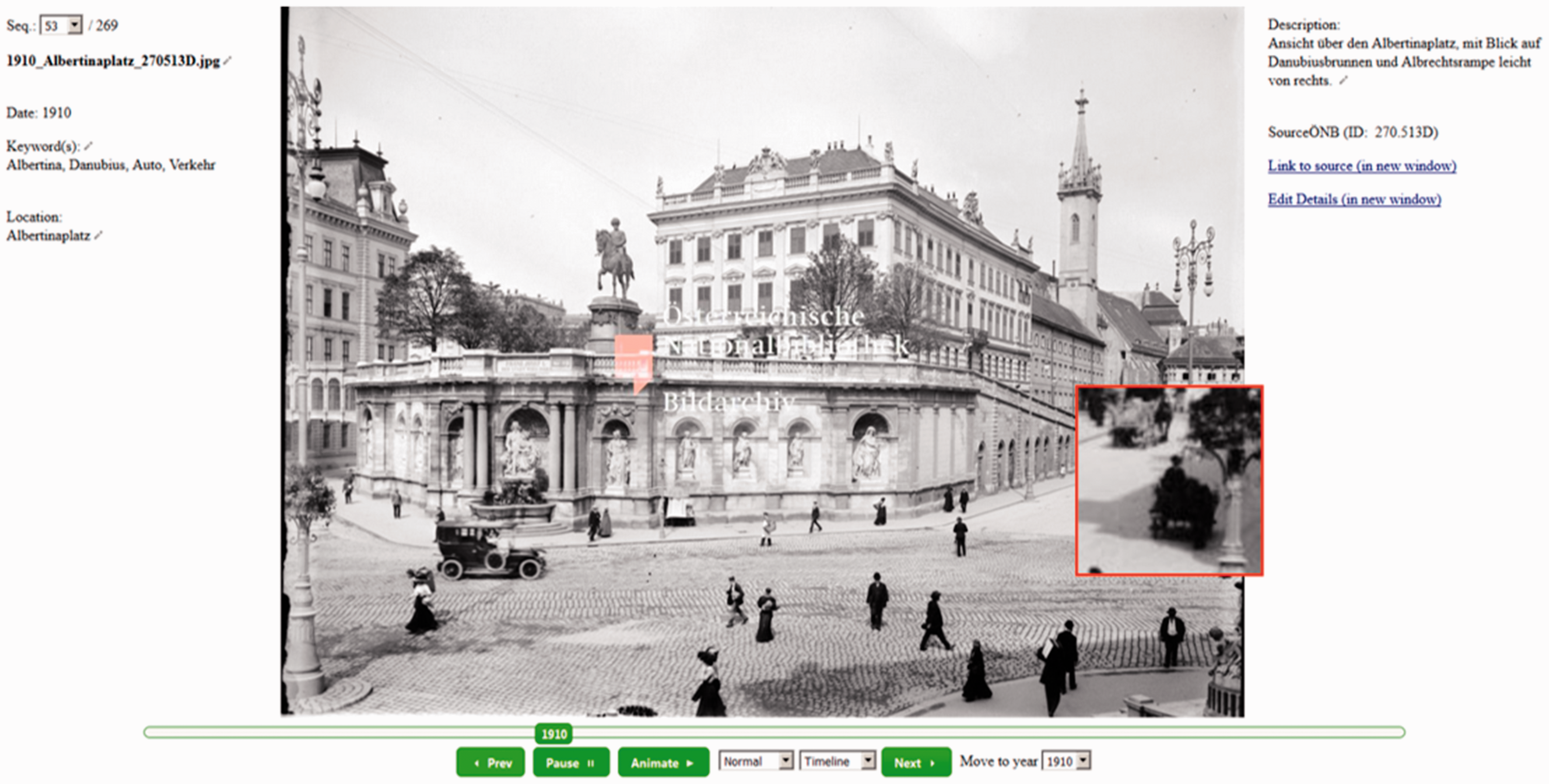
The tool was programmed in an extendable manner so that numerous filter options that allow for specialised searches within the uploaded photographs can be enabled in the future, and information about the angle of each photo can be embedded. This will enable more specific slideshows, such as a timeline of photos of a particular segment of a street seen from the same point, making a fixed-point observation possible. The tool is designed in a way so as to be published on the Internet, though at the moment it is not publicly accessible because of copyright issues.
IPTA
The method of (historical) photo analysis ultimately chosen as the inspiration for our research design is the serial-iconographic method developed by Mietzner and Pilarczyk. 28 Combining qualitative and quantitative approaches, this method allows for the representation of not only one-off events, but also the recognition of continuities, discontinuities, peculiarities, and deviations over a particular period of time, from which conclusions about particular phenomena can be drawn. While the advantage of a serial or quantitative analysis is to guard against the overemphasis of one-off events, our additional qualitative analysis provides the kind of depth and detail that is quickly lost in purely quantitative approaches. Moreover, we consider a serial – or quantitative – approach to be appropriate for the study of everyday objects, which underlies our research interests on changes in street use and design. It also enables us to deal with the large sample of photos to be analysed within our research.
Building upon the serial-iconographic method developed by Pilarczyk/Mietzner, we developed a four-step analysis systematic, which we call IPTA. Our analysis systematic can be summarised as follows:
Identification of the photo archive and data collection, and preliminary selection of the photos to be analysed Development of interactive tool; data input of the photographs into the tool, and classification of the photographs by adding basic metadata Quantitative analysis of each individual photograph; development of codebook to classify the visual content of the photographs in a systematic way Qualitative analysis workshops: timeline analysis of photographs using the interactive tool and focusing on long-term continuities and changes
The first step is to set up a dataset of the photographs to be analysed from an existing archive based on the subject of analysis. This methodology has a further potential to make use of crowdsourcing to collect photographs from private archives, which would never be published otherwise: this will greatly extend the availability of photographs. In this case, the first step will need to be combined with the next step as some of the metadata needs to be provided by the photograph owners.
The second step is to put the photograph into the analysis tool we developed, while simultaneously classifying the photographs by adding basic metadata – if known – such as photographer, date and time the photograph was taken, initial intended use, photograph resource or credit, geo-location, etc. This set of metadata enables preliminary classification based on descriptive categories, keywords, locations, and year, allowing for a qualified, systematic selection of photos to be analysed. It is then possible to effectively establish a systematically comparable reference portfolio based on thematic focus, historic periods, or location, as well as by specific research questions.
In a third step, a reference portfolio is established according to time periods referring to historical, socio-political, and/or technological developments. This is followed by the quantitative analysis of each individual photo in the database, which is carried out using a codebook. The codebook serves to standardise both the observations and vocabulary used to describe the visual content within the photographs, on the one hand, and also provides the underlying framework for the IPTA tool, on the other hand. It thus provides a foundation for analysis, but is itself also derived from the data, creating an interactive feedback loop to refine and focus the analysis.
Complementary to the quantitative analysis, a fourth and final analysis step consists of several workshops, in which photographs are analysed in a qualitative way using the IPTA tool we developed, and building upon the results of the quantitative evaluation. As suggested by Pilarczyk/Mietzner, the qualitative photo analysis is conducted following the three-step model of pre-iconographic description, iconographic analysis, and iconological interpretation developed by Erwin Panofsky. 29 As every photo is captured in the online database and marked with details on year and month taken, weather, city, exact location (geo-codes), purpose of photo, special event, historical or political context and keywords, the prevalence of street use, street users and street design can be compared from photo to photo, taking arbitrary time periods into account. Changes in urban street use and design can be made visible through such a fine-grained analysis.
While IPTA can be applied in various fields, the benefit of it is most apparent in the domain of urban history research as the geo-referenced database and the handling of a large number of the digitally stored photographs can be fully deployed. The benefits of these features are especially clear in examining the history of urban street space because the dynamics of a city become most visible in photographs, and the availability of historic photographs is likely to be high.
Theoretical framework
Defining analytical categories
In order to narrow our research questions and also to structure the content of historical photos in a systematic way, it was necessary to develop useful analytical categories to work with. Being interested in urban street space and its various functions, as well as in the changes they underwent over time, we therefore decided to use the classifications ‘living space’ and ‘transportation space’, which are comprised of the associated subcategories ‘street use and users’ and ‘street design’.
As discussed below in detail, the urban street serves on one hand as a primary transportation space, while on the other hand it serves as an urban living space where various types of social, commercial, and cultural activities take place. An analysis of the interrelation between these two types of use of the urban street will not only reveal historical changes and therefore benefit urban history in general, but it will also benefit transportation and urban research in particular, as it contributes to a deeper understanding of the interactive development of the urban transportation space.
Urban street space and its uses
Street space in urban areas has continuously evolved to play an important role in urban lives. On the one hand it has evolved to serve as a primary transportation space for pedestrians, bicycles, cars, buses, streetcars, and to some extent the parking of vehicles. On the other hand, it has evolved to serve as a type of urban living space in which certain aspects of urban lives, such as vending, meeting with others, advertising, eating/drinking, resting, etc. take place.
Regarding the street as a transportation space, the spread of new transportation modes (streetcars at the end of the nineteenth century, massive prevalence of cars since the 1950s) and changing transport policies have played a significant role in shaping street design. Especially the diffusion of automobiles has shaped the street space towards the needs of motorised means of transport. This includes both hard designs, known as ‘geometric designs’ among traffic engineers, and soft designs such as traffic regulations and technical standards. With the evolution of street space in cities, new aspects of city life gained in importance. At the beginning of the 1970s, an increasing awareness of re-conquering street space from automobiles for a fair distribution to all street users, especially non-motorised users, can be observed in the establishment, for example, of pedestrian zones and shared spaces. 30
The street as an urban living space refers to the human use of streets, and the range of activities carried out on streets over time at the micro-level. It includes both active use in which the users are present, engaging in activities such as strolling, shopping, social activities, protesting, etc. and passive use by non-present users, represented by parked cars, garbage collection, advertisements, etc. The street as a living space in which various non-transport activities are carried out has also seen substantial change over time. In this, the street as an urban living space and as a transportation space can be seen as a complex set of mutual interactions.
Interactions between urban living space and transportation space
Urban street space has seen substantial changes over time. There is a clear interaction between changing street use and the changing physical design of streets and legal regulations; changing traffic codes and street design can affect the human street use, but changing street use can also influence the physical design and legislation of streets. Some changes have immediate impacts, while others occur with a time lag. Understanding the interrelations between the two different types of street use identified above, as well as their manifestations, was a central aim of our research design.
Given the two different perspectives on urban street space as a living space and transportation space, an analysis of the interaction between these two types of use will first of all reveal the history of urban streets itself. Mutual impacts and their manifestations can only be traced through a long-term historic analysis. As these changes manifest on different levels in society, economy, street shape, regulations, etc., an interdisciplinary consideration is necessary to capture such complex networks. The expertise of disciplines such as history, social sciences, economics, transport history, and transport planning is therefore fundamental for urban history research.
In order to develop and utilise the IPTA methodology described in ‘IPTA’ section, a pilot project was conducted, with the streets around the Vienna State Opera serving as a case study. Based on the theoretical framework outlined above, the research addressed the following questions: What were the reasons for changes in both the street as an urban living space and as a transportation space? Which transport-related factors can be identified as relevant, but also which non-transport-related factors contributed to changes in street use and street design? How has the social use of streets as public spaces evolved and been shaped through and around the development of transport in the industrialised age?
Application of IPTA
Case study – Area around the Vienna State Opera
To develop and refine our IPTA methodology as detailed in ‘IPTA’ section, we carried out a small case study for a limited area of street space in Vienna. The case study consisted of a six-month pilot project conducted between October 2016 and March 2017. Through this we devised and tested the four steps of our methodology. This section details how we applied the IPTA methodology in practice.
Due to resource restraints as well as limitations of digitised historical materials publicly available in the archive of the Austrian National Library, the historical time period examined in this initial project begins in the 1860s and ends in 1949. Nonetheless, this period covers the major disruptions of the twentieth century, not only socially and politically, but also with regards to new forms of public and private transportation within Vienna, and particularly in the area around the Opera.
The case study focused on the area around the Vienna State Opera as shown in Figure 2 below.
Map of research area.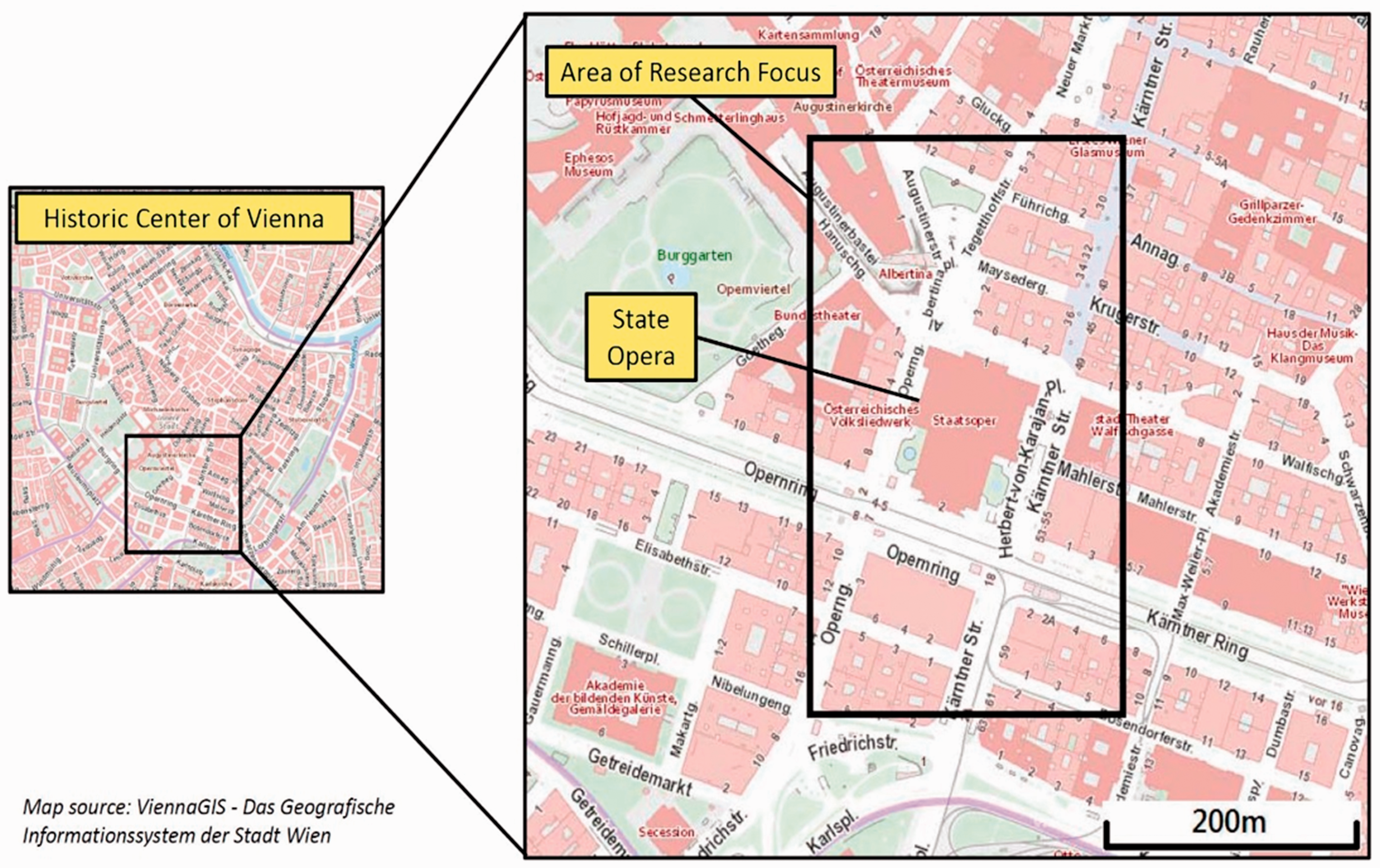
The area within the black box shows the streets around the Opera for which historical photos were collected and analysed in our case study. The area includes the ‘Opernkreuzung’ (intersection of the Ringstraße and Kärntnerstraße), the ‘Opernring’ (portion of the Ringstraße directly in front of the Opera), and the area around the Albertinaplatz. The researched area does not necessarily represent ‘typical’ streets in Vienna, but is rather a highly visible, well-documented, and much visited area near the city centre. Further steps to expand the geographical scope to better understand changes in street use and street design on a more general level for the city as a whole are discussed in ‘Future outlook’ section.
Application of IPTA to case study
The methodological approach followed the four steps of our IPTA (see ‘IPTA’ section).
In a first step we collected 269 historical photos from the publicly available, digitised photo archive of the Austrian National Library, using specific keywords (e.g. Staatsoper, Opernring, Oper, Kärntnerstraße, etc.). The search results were then filtered for photos taken within the case study area around the Vienna State Opera. In a second step the collected photos were entered into a database. Basic metadata such as year, geographic location, etc. was added manually to each photo for a first classification. We also began programming our IPTA tool, which was successively amended in tandem with the development of the codebook and database in step three.
In the third step, the collected historical photos were analysed quantitatively. For this purpose, the visual content of every individual photo was analysed in accordance with the defined categories of the codebook and entered into the database. The observation-based data following the codebook included data on street infrastructure for different modes of transport (number and quality of vehicle lanes, tramway infrastructure, sidewalks, parking space, signage, etc.), street furniture (street lighting, seating, vegetation, barriers, etc.), as well as on consumption areas (shops, cafés, etc.). Additional data on street users (number of people, gender, estimated age, number and type of vehicles, etc.) and street use (activities such as walking, cycling, consuming, begging, construction works, advertising, etc.) were analysed and entered into the database. This process was rather time consuming given that every photo had to be closely inspected. The codebook was devised making use of secondary literature and existing transport planning and traffic engineering expertise in our research team. It was continuously expanded and adapted over the course of the quantitative research according to our findings, and as missing categories were added.
In a final fourth step, a qualitative analysis was carried out. In a series of workshops, the photos were evaluated and interpreted from both a transportation space and urban street space perspective, using features of the IPTA tool, such as a magnifying glass and slideshow function. This yielded a few distinct categories of relevant observations:
Vehicle dominance v. pedestrian dominance – distribution and demarcation Transport regulation and organisation Transport means – what appears and disappears at what time Non-transport activities
Based on these main categories, the key changes in street use and street design were compiled and analysed. The different backgrounds and disciplines of the members of the research team proved to be especially enriching during this analysis step.
Initial analysis results: Street as urban living and transportation space
The following initial results are examples of what can be gained from the IPTA methodology. In analysing the historical photos in our dataset over the long term using the timeline function of our interactive tool, big picture changes in the street as a living space and as a transportation space came into focus. However, some caveats are also in order.
Changes in the street as a living space
The street and its changing use by people as a space to live out certain aspects of their lives is at once an obvious, and simultaneously a largely intangible, aspect of urban studies. Using newly available technologies, our study of the streets around the Vienna State Opera in the late nineteenth and early twentieth centuries allowed certain long-term developments in the changing cityscape and street use to become visible. These include the use of the street as an information space, the rise and decline of certain professions over time, and the changing aesthetics of the street space.
A qualitative timeline analysis of the photos collected around the Vienna State Opera reveal marked changes in the use of this space as a way to communicate information to the public. The street has always been used as an informal meeting place where information is exchanged among locals and residents, but the appearance of new forms of communication methods between administrative or commercial interests and local residents become evident in our dataset around the 1920s (see Figures 3 and 4).
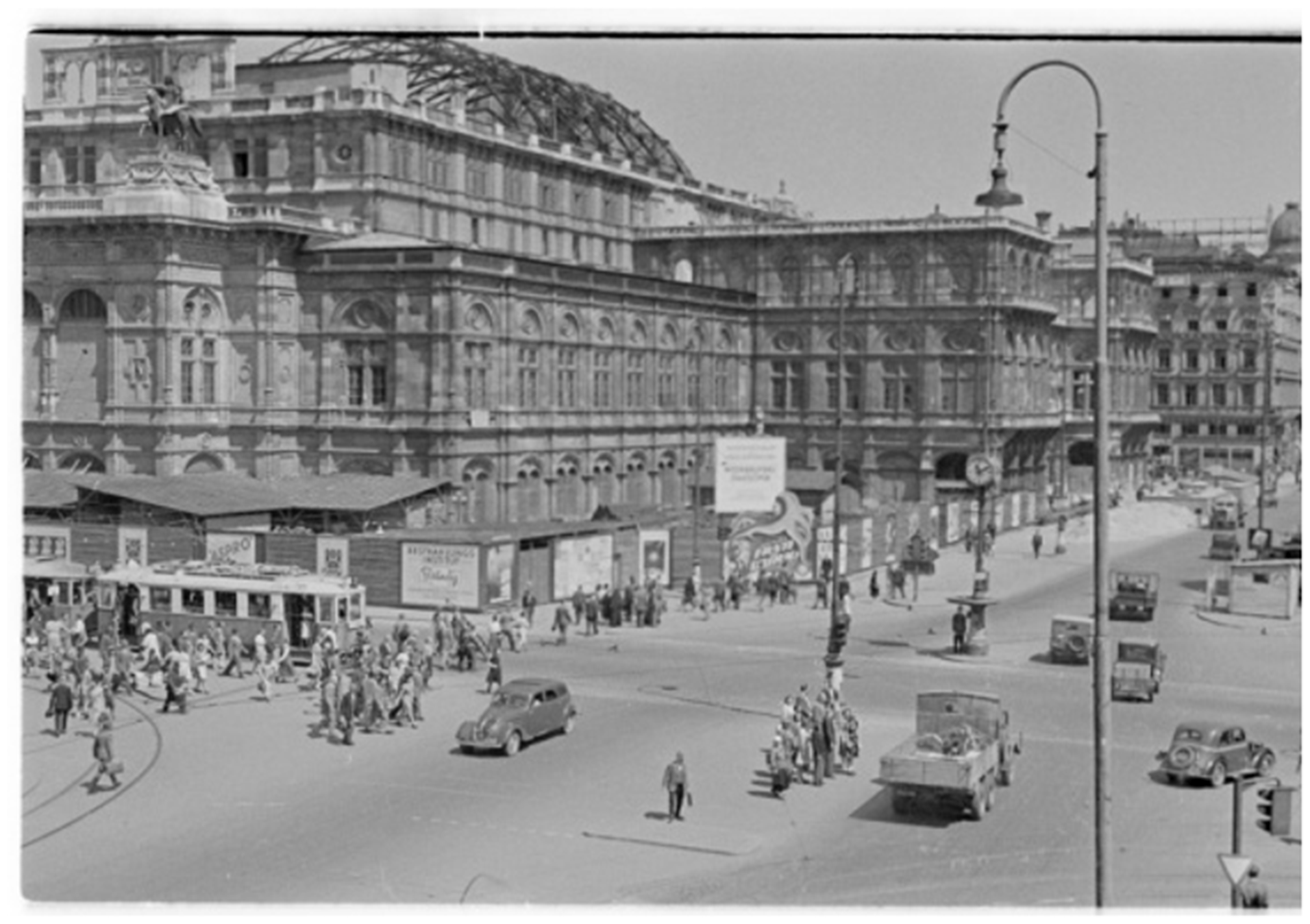
Opernkreuzung around 1920.31 Opernkreuzung around 1920.32 Opera 1947.33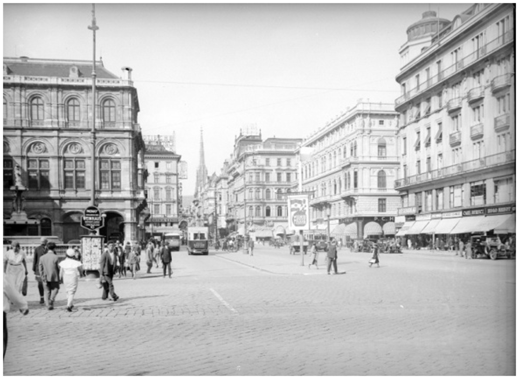
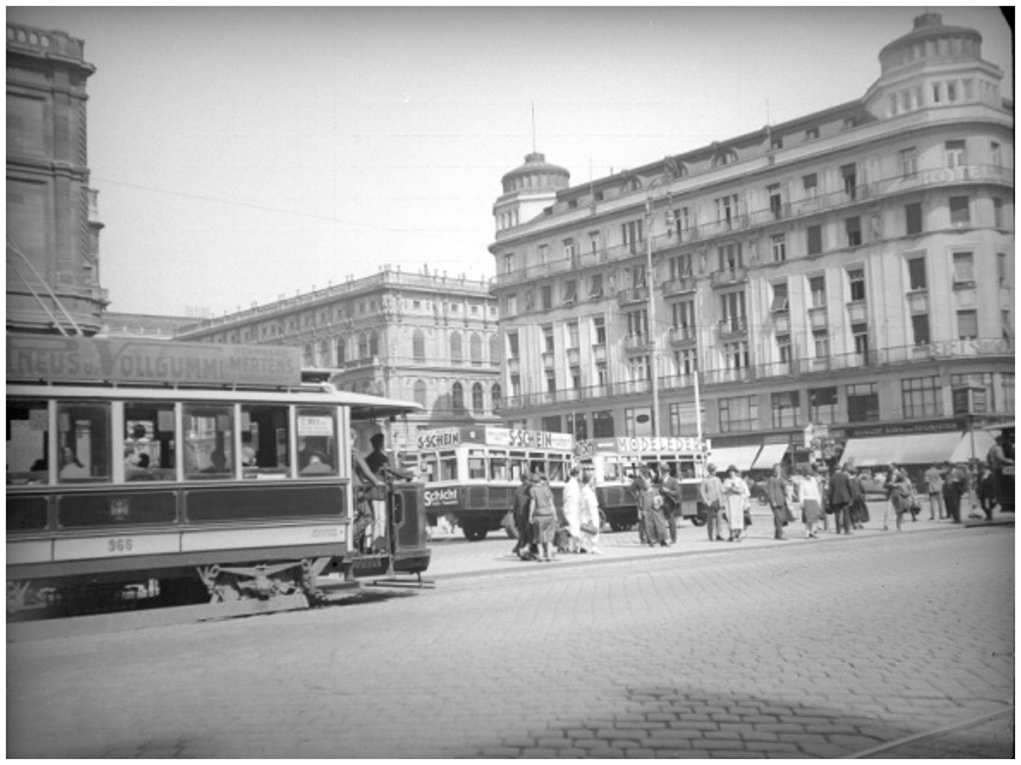
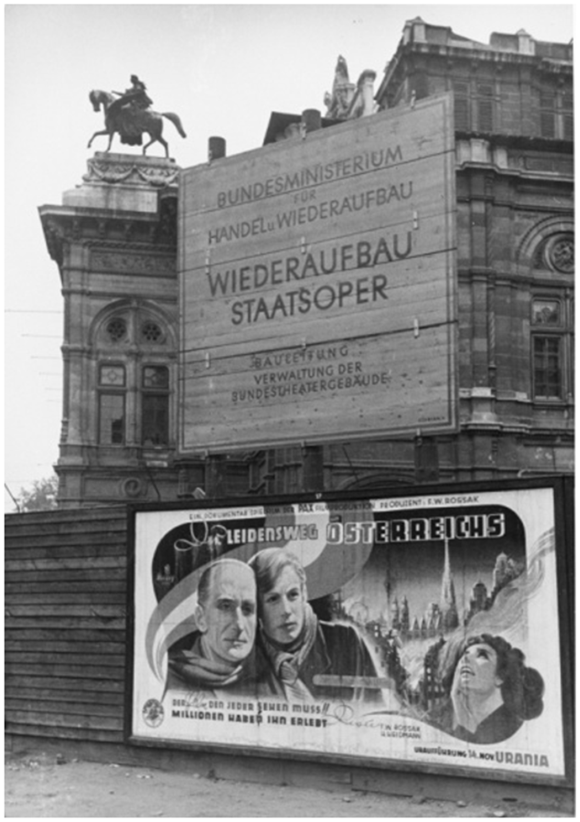
Around this time, a noticeable increase in the amount of information available on the streets around the Opera can be observed, including advertising, propaganda, and loudspeakers for radio announcements. Throughout the war years, NS propaganda takes over, whereas the immediate post-war period sees a shift towards more publicly posted information from the city administration about what construction is being done, and where money is being spent. This can be seen in Figure 5, in which a large placard informs the public about the government ministry responsible for the reconstruction of the Opera after the war. Such information is not visible in our dataset in the pre-war period and provides visual cues towards changing ideas of governance and transparency in the twentieth century. The proliferation of advertisements as seen in our dataset in the twentieth century, from early advertisements on buses and trams to the construction fencing used during reconstruction of the Opera, further provides insight into the emerging use of the street space by passive users over time.
Alongside the changing nature of the street as an information space, a long-term timeline view of the streets around the Opera provides insight into the changing professional structure of the city, or at least the changing visibility of different professions, over time. In the earlier photos in our dataset, street sweepers and street cleaners appear relatively often, but begin to disappear from view by the early twentieth century. This appears to correlate with the emergence of motorised vehicles, and we posit that the decreasing number of horses on the street made this work less necessary, while the higher speeds of automobiles made sweeping the street more dangerous. Instead, new forms of street cleaning arise, and the street sweepers slowly become less prevalent. 34
While street sweepers begin to disappear from photographs, new professions on the street begin to emerge. Among the most evident in our dataset are billposting and shoe polishing, both of which begin to appear in our photo sample around 1930.
Billposter around 1930.35 Shoe-polisher around 1930.36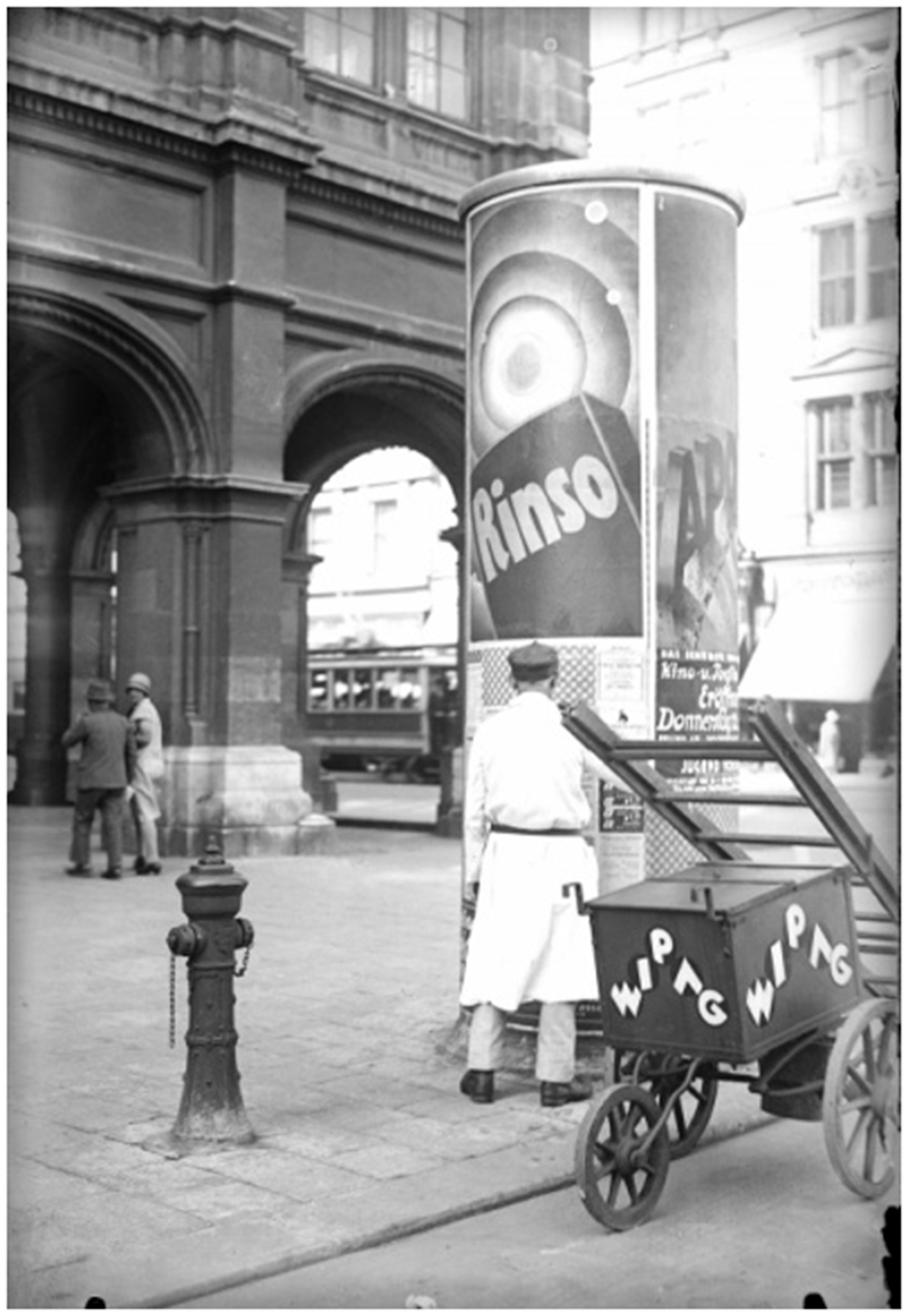
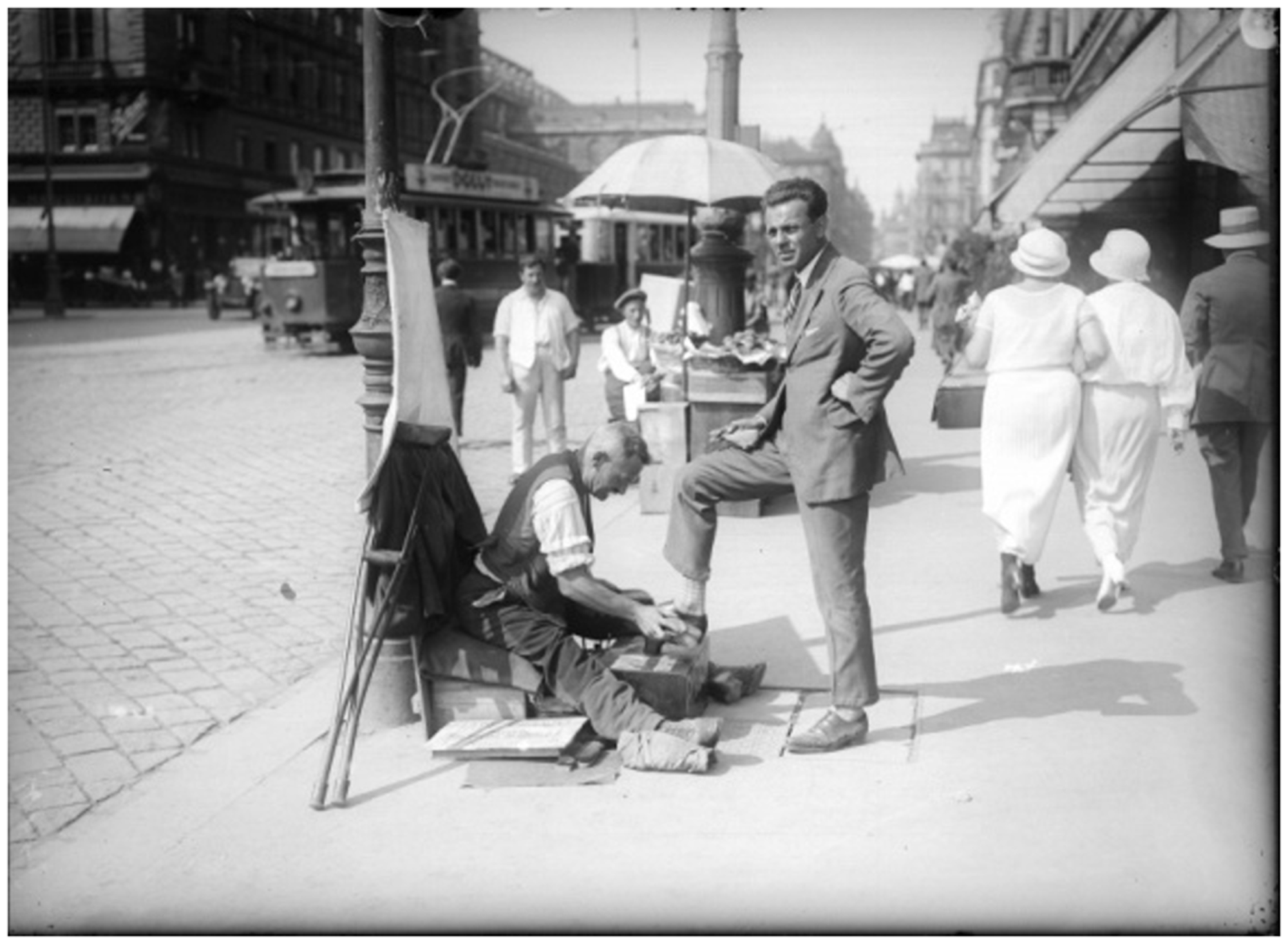
The fact that billposters appear in our photos around this time tracks with the increase in visible advertising that can be seen starting around 1920. An example of this can be seen in Figure 6. The proliferation of both shoe polishing, as seen in Figure 7, and billposting point towards the increasing commercialisation of the street space and correlate closely with the emergence of more information and advertisements on the street.
Another benefit of a timeline view rather than a static view of the streets around the Opera is the ability to visualise the changing aesthetics of the street space over time. We can observe changes in street furniture, which provide an insight into ideas about modernity, in terms of both the aesthetic and practical value of street space for local residents. Some of what we observe in our photo sample is the appearance of electric street lamps, which begin to appear around 1910, with an elegant design and integrated pots for flowers and other plants. These can be seen in Figure 8.
New aesthetics of street furniture (e.g. lamps) around 1910.37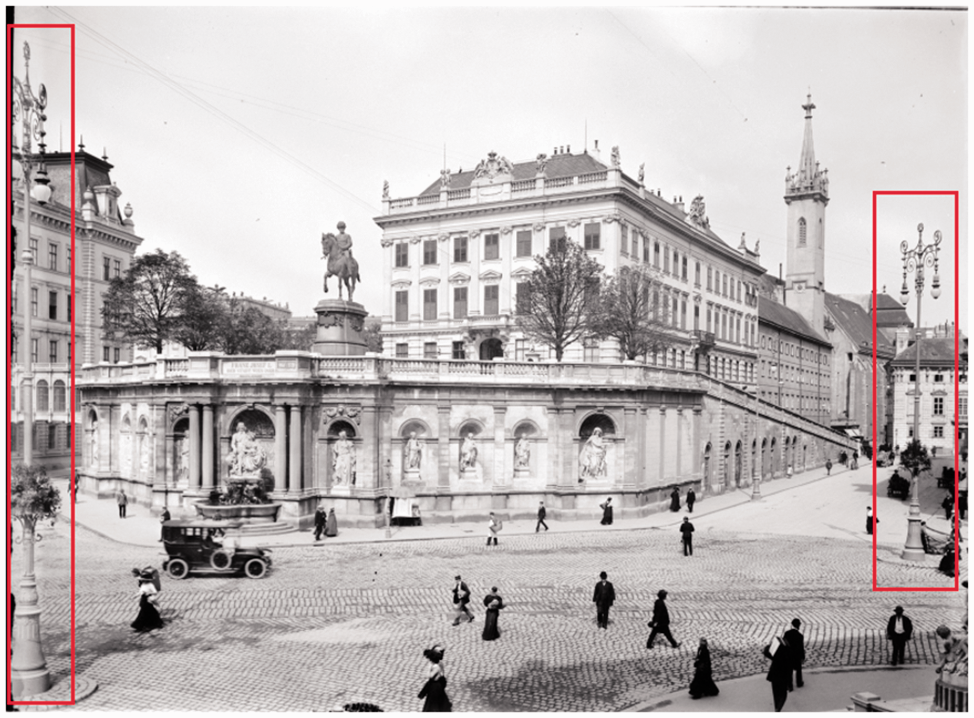
Thus, a new aesthetic begins to emerge, which is facilitated by the fact that these lamps do not need to be lit by hand and can therefore be both taller and more decorative without impeding their function. Overall, our timeline view from 1860 to 1949 shows that street furniture as a whole becomes much more prevalent and varied over time; we observe a visual increase in furniture such as benches, mailboxes, and fixed trashcans during this period.
Changes in the street as a transportation space
In addition to providing a visual history of changes to the street as a living space, our IPTA also allows us to see how the streets around the Vienna State Opera change as a transportation space over time. This includes both evolutions in streets design as well as the use of the street as a transportation space.
From the 1860s until the end of the 1940s, significant changes in street design become visible in the photos. No street markings are visible on any of the streets around the Opera until 1920, but the Ringstraße has a clear design from the start with obvious lanes, curbs, and tram tracks (see Figure 9). Other streets around the Opera also have curbs and designs within the cobblestones that serve as a form of demarcation.
Early street design of Ringstraße, 1876.38 First street markings visible in photo from 1937.39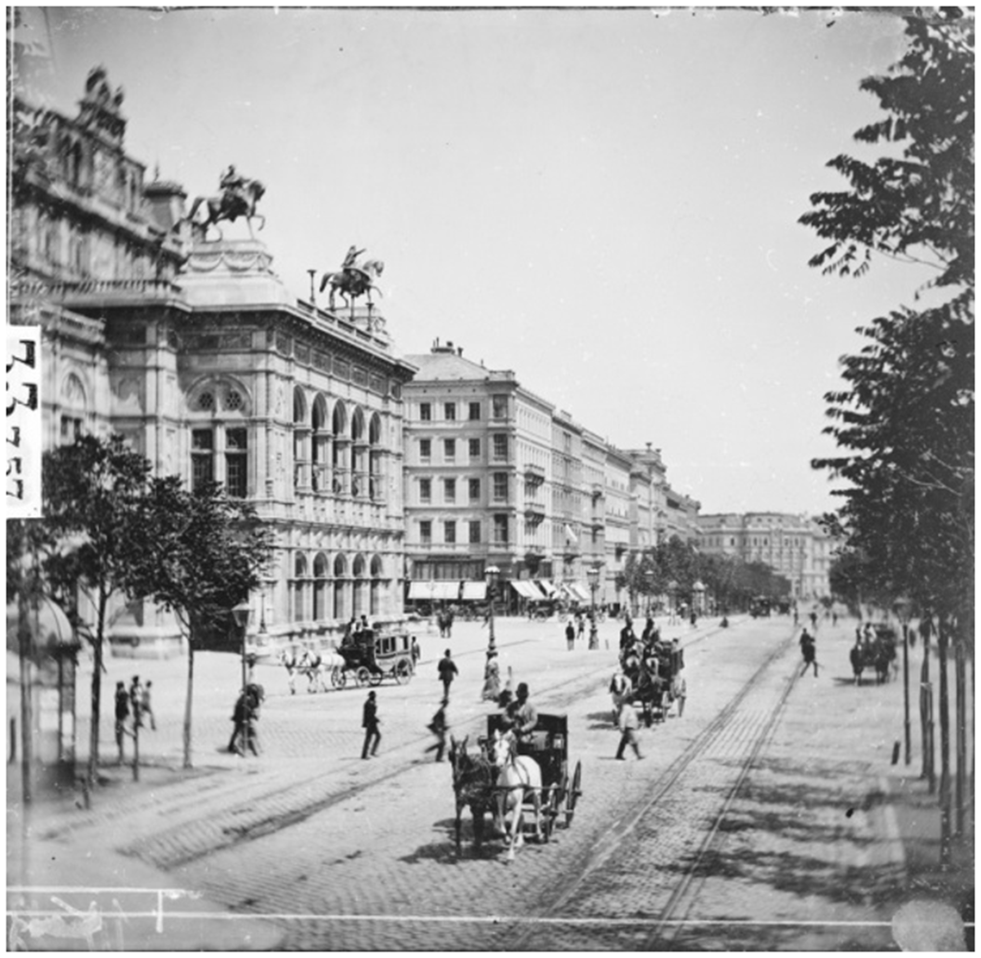
Although informal lanes and street parking exist earlier, the first street markings and designated parking spots do not appear in our sample until the 1930s (Figure 10). Marked lanes for pedestrians first appear in 1937, though there is still no stop light for pedestrians at this time. The first traffic light for vehicles in Vienna is installed at the intersection of Kärntnerstraße and the Ringstraße in front of the Opera in 1926, and first appears in our sample in an undated photo from before 1930. Traffic signs, such as a ‘no parking’ sign, first become visible in 1938. In the immediate post-war period more street signs become visible, including street orientation signs and bus timetable schedules, most likely erected for and by the post-war occupation forces who would have required more navigational instructions than the local population.
Another change in the use of the street as a transportation space that can be seen over time is the self- and design-determined organisation of traffic, as well as the pedestrian and vehicle dominance of the street. In the earlier period of our analysis, up until around 1910, pedestrians use all parts of the street, while coaches and other vehicles use only the centre of the street (see Figure 11). This resembles something like the modern concept of Shared Space, in which the street space accommodates vehicles but is largely oriented around pedestrians. 40
However, as motorised vehicles become more prevalent and powerful, the dominance of vehicles over pedestrians begins to assert itself. New accommodations such as parking spaces next to the Opera are built, and both the design and use of the street as a transportation space gradually become more organised by the 1930s. In tandem with this, our photo timeline shows pedestrians also becoming more disciplined, with people waiting in particular places to cross the street even where no designated stop light exists. This sort of self-organization can be seen in Figure 12.
Caveats
While our case study of Vienna allowed us to utilise our IPTA methodology to see some long-term changes in the street space around the Vienna State Opera, it is a relatively small-scale application of the methodology and represents only an initial attempt. Some of the observed changes to the use of street space, such as the emergence of previously unseen professions, may not reflect a true increase in these activities over time, but rather an increased interest in photographing such activities. A larger dataset as well as augmenting written materials would help to mitigate some of these problems.
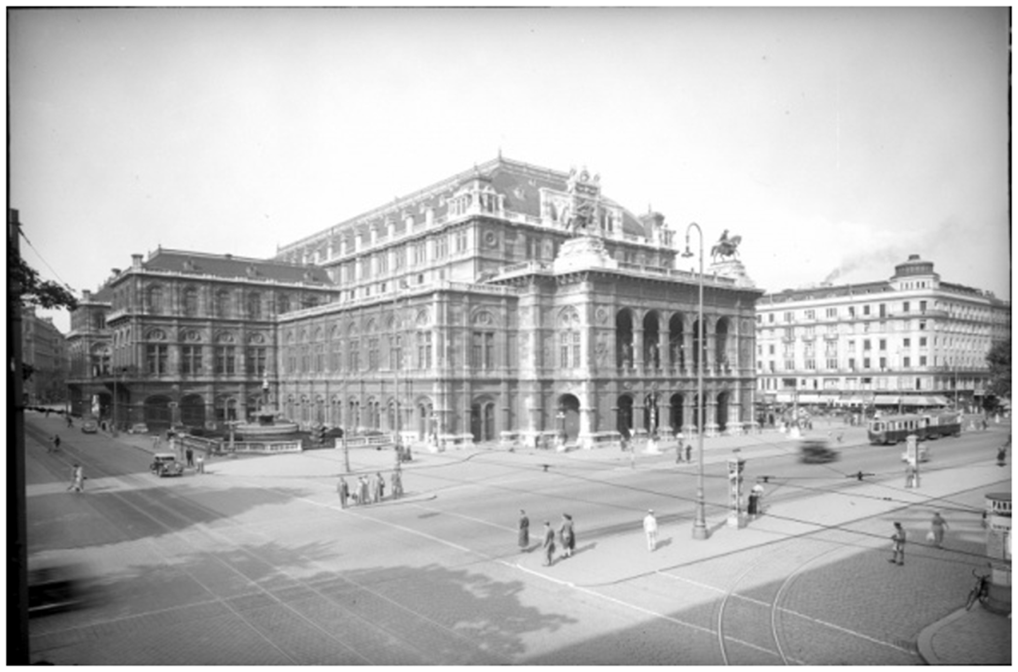
Pedestrians make use of whole streetscape, 1876.41 Clear separation of streetscape, 1948.42
Conclusion
Lessons learned
Throughout the course of this research, there have been several outcomes that have both guided our research and shown potential for further improvement. Ultimately, we were able to develop a methodology that makes use of new technologies and the availability of digitised photographs, and were able to apply this method in our case study of the streets around the Vienna State Opera. The biggest takeaway of our research efforts is that this kind of methodology can be successfully applied across various disciplines to answer a broad range of research questions. Furthermore, it provides an avenue for future researchers to utilise long-term visual timelines and photo analysis as a research tool.
During our research, we also recognised the clear value of having an interdisciplinary team with different academic backgrounds. This helped us to gain insights that likely would have been lost in a more homogenous team and forced us to consider new perspectives. This was most clearly realised in the development of the IPTA methodology and the analysis workshops, and our research benefited greatly from having a diverse research team.
The application of our IPTA methodology to the Vienna State Opera case study highlighted some of the benefits and drawbacks of photo analysis in historical research. We chose to approach our research from both a quantitative and qualitative perspective, and drew inspiration from the serial-iconographic methodology developed by Ulrike Pilarczyk and Ulrike Mietzner. We consider such a two-pronged approach to be important, with the quantitative aspect shielding against the overemphasis of one-off events, and the qualitative aspect providing the necessary historical and interpretive context. Nonetheless, we found that a quantitative analysis only becomes truly useful with a much larger sample size.
In addition, comparability poses an ongoing challenge, especially for a quantitative approach. For more robust research results, it would be necessary to have a large number of photos that are comparable in terms of framing, weather conditions, and across different time periods, to name a few. In addition, one of the core methodological challenges to this kind of analysis is separating special events from everyday occurrences. As photos only capture a particular moment in time, and are not objective depictions of reality, it can be difficult to determine the true significance of any one photo. These challenges can however be overcome to some extent by having a large sample size and putting the photo in its historical context, thus allowing everyday patterns to emerge.
Future outlook
The use of technology and large, digitised photo archives offer great potential for historical research. The initial application of such a methodology to the small case study of the streets around the Vienna State Opera opens up many new avenues of inquiry. In our research, we were able to determine the availability of digitised and accessible visual materials at the Austrian National Library up until the end of the 1940s. A next step would be to diversify the photo source, including newspapers, local city archives, and personal archives. Crowdsourcing historical photos from personal archives allow researchers access to historical sources in entirely new and novel ways. Initiatives like Vintage Vienna have laid the groundwork for such mass collaboration, and these emerging communication platforms should be utilised by researchers. Not only can this provide access to previously inaccessible materials, but it also helps to remove historical research from its proverbial ivory tower by involving the public as active stakeholders in academic research.
In addition to diversifying the visual materials used in our research, a further step would be to utilise written sources such as traffic codes, statistics, police records, planning documents, and newspaper articles. Such materials help to contextualise photos and would allow for a more complete understanding of changing street use and street design around the Vienna State Opera.
Our small case study provides initial research insights into the use of the IPTA methodology, but is not representative of overall changes in street use and design in Vienna; for this, we would need to expand the geographic scope. As became clear in our case study, research of even a small geographic area calls for a great deal of human resources. A realistic approach to expanding the scope would be a street-by-street analysis, perhaps by multiple research teams, to enlarge the geographic coverage. This would allow for an accumulation of results from different streets located throughout many different areas of Vienna, from which more meaningful conclusions for the city as a whole can be drawn.
Over the long term, we also see our methodology as a small but important step towards the use of machine learning in historical research. Although still in relative infancy, machine learning is becoming ever more sophisticated, and holds great promise for research using large databases of visual materials. Currently, data input is a time-consuming and laborious process. However, over time and with large samples, machines can begin to recognise visual details and generate large datasets from which new patterns may emerge. This would greatly ease the quantitative evaluation of photographs as described in step three of our IPTA methodology, allowing researchers to focus on analysis and qualitative factors, which are and will continue to be necessarily human aspects of academic research. In order to realise these benefits, several technical barriers such as accurate machine recognition of details in black-and-white as well as low-resolution photographs still need to be overcome. Nonetheless, we see this not only as the future of technology, but also the future of research using large visual datasets.
Footnotes
Acknowledgements
This research was funded by the Club of Vienna. We thank them for their generous support. We also thank the JTH reviewers for their very insightful comments, which helped us to strengthen and restructure the paper. Additionally, we would like to thank the editor of JTH for his constructive feedback and support. Lastly, several enlightening conversations with René Winkler provided new insights into technological developments and their application to scientific research.
Declaration of conflicting interests
The author(s) declared no potential conflicts of interest with respect to the research, authorship, and/or publication of this article.
Funding
The author(s) disclosed receipt of the following financial support for the research, authorship, and/or publication of this article: The research was generously funded by the Club of Vienna, and the WU Wien University Library provided financial support through its Open Access Funding Program.