
Abstract
How can attention to spatial dynamics improve our understanding of where, how, and why conflict-related violence (CRV) concentrates within postwar cities such as Mitrovica? Like many other postwar cities, Mitrovica – one of Kosovo’s largest cities – remains affected by violence connected to the preceding war. This violence is not equally distributed across the city but rather concentrates to certain flashpoints while other sites are comparatively calm(er). To date, however, research on postwar cities has not fully explained such patterns, partly due to limitations in microlevel data. In this article we rely on novel georeferenced data on CRV, in combination with in-depth fieldwork, to map CRV in Mitrovica and explore the causes for its spatial clustering. Using this approach, we show that CRV concentrates at Mitrovica’s Main Bridge and explore this concentration using relational space as an analytical lens. The analysis contributes new insights into patterns of violence in Mitrovica, demonstrates the value of combining systematic data on the patterns of CRV with in-depth exploration into its underlying dynamics, and contributes to existing research on Mitrovica as well as on postwar cities and postwar violence more broadly.
Introduction
How can attention to spatial dynamics advance our understanding of where, how, and why conflict-related violence (CRV) concentrates within postwar cities such as Mitrovica? While never that central during the Kosovo War in 1998–1999, Mitrovica has emerged as the postwar epicentre and hypocentre of enduring problems, including ethnonational division and continued CRV (Boyle, 2010, 2014; Gusic, 2019a; Jarstad & Segall, 2019). In the decades since the war ended, violence between Albanians and Serbs – often involving Kosovo Force (KFOR), United Nations Mission in Kosovo (UNMIK), or European Union Rule of Law Mission in Kosovo (EULEX) personnel – has continued. And while things are calmer today, ‘the tensions are there and can always escalate […]. A small, small spark can create a large fire’ (local United Nations Development Programme (UNDP) official, interview, 2015).
This violence is not equally distributed across Mitrovica, but concentrates to certain flashpoints while other sites are comparatively calm(er) (Jarstad & Segall, 2019; Bátora et al., 2020; Gusic, 2022). The Main Bridge over the Ibar river – connecting Mitrovica’s Albanian-dominated south with its Serb-dominated north – stands out as it has been the flashpoint of CRV during the postwar period: ‘something happens at the bridge and then we are back [to war]. During all these years, the bridge has been the flashpoint of unification and division’ (local lawyer, interview, 2015).
Yet despite growing attention to postwar Mitrovica, few studies have analysed how violence clusters and why. 1 Doing so is the principal aim of this article. By combining systematic mapping of violence with inductive analysis of what shapes its distribution, we demonstrate how society and space together condition the concentration of violence in Mitrovica. Our analysis thereby speaks to the broader literature on postwar cities – cities which have experienced war, no longer do, but remain contested (Gusic, 2019a) – which also showcase an uneven distribution of CRV. The Main Bridge is undoubtedly a peculiar site with its KFOR checkpoints and continued violence. Mitrovica itself – with its stark divisions and parallel institutions on the one side and it being the only Kosovar city where Albanians and Serbs meet regularly on the other side – has also made it an unusual city in the local context (Björkdahl & Gusic, 2013). No other sites in Kosovo are as diverse, experience as much conflict, or provide people with so many opportunities for contact (see Gusic, 2022). Yet these unusual traits in the Kosovar context resonate with other postwar cities, with which Mitrovica – even if it has contextually grounded differences – shares many similarities. The walls in Belfast or checkpoints in Beirut are also materially marked by violence, symbolically important, and politically contested. Mostar and Jerusalem likewise feature lived parallelism and contestation while providing citizens with comparatively high contact with ‘the other.’ So, while the Main Bridge and Mitrovica are unique in Kosovo, their idiosyncrasies can – in both parallel and other forms – be found in other postwar cities around the world.
Through our exploration of violence in postwar Mitrovica we make three key contributions. We make a theoretical contribution to the literature on postwar violence by demonstrating how the mutual constitution of society and space helps explain microlevel variation in where violence happens and why. We also add urban insights to this literature. While research on postwar violence studies microlevel patterns, it has paid little attention to how violence is spatially contingent – for example, violence in cities tends to take on urban dynamics that need to be explored per se to understand how violence concentrates in postwar cities (Bollens, 1999; Rokem, Weiss & Miodownik, 2018). By exploring how and why violence concentrates in Mitrovica we advance knowledge on how cities shape postwar violence. We argue that the analytical lens we employ could be extended to, tested in, and shed light on other postwar cities. We also make a methodological contribution to the study of postwar cities, which to date has been hampered by limitations in data on violent events as these are either too aggregated and/or not systematically collected. Our data on Mitrovica are the first outcome of an ongoing project which systematically maps CRV in postwar cities at maximum possible geographical precision. This unique data collection illustrates how fine-grained data can be gathered systematically – within and across postwar cities – and how useful geo referencing violence to the street-level is. Our analysis shows how combining this systematic data with an inductive analysis of qualitative data helps us deepen the understanding of CRV in postwar cities. We lastly make an empirical contribution to the understanding of violence in Mitrovica, highlighting how different spatial aspects of the postwar city deepen the understanding of where violence concentrates and why.
This article is structured as follows. We first survey existing research on CRV in postwar cities and contextualize Mitrovica therein. We then introduce relational space as our analytical lens for understanding the concentration of CRV as well as present our dataset and the in-depth fieldwork used to understand its patterns. We then map CRV in postwar Mitrovica before analysing why substantial parts of it has concentrated to the Main Bridge. We conclude with broader insights which shed new light on under-explored dimensions and potential research beyond Mitrovica.
CRV in postwar cities
It is well-established that CRV tends to continue even after hostilities cease, victories happen, or peace agreements are signed (Muggah & Krause, 2009; Suhrke & Berdal, 2013; Bara et al., 2021). CRV refers to violent acts related to the preceding war – for example, revenge attacks, violence between polarized communities, and violence by former warring parties – including both strategic violence advancing political goals and criminal or expressive violence (Bara et al., 2021). Recent literature has improved knowledge about how such violence relates to peacebuilding challenges; morphs into new forms with changing actors and strategic incentives; and is strategically employed by elite actors (Muggah & Krause, 2009; Boyle, 2010; Barron, 2019; Bara, 2020). Empirical analyses have also made use of disaggregated data to analyse subnational variation in postwar violence, which often displays new spatial patterns (Boyle, 2014; Barron, 2019; Bara, 2020). Notably, postwar violence tends to be more episodic and concentrated (Barron, 2019: 21) while cities are often particularly affected (Bollens, 1999).
Existing research has demonstrated that CRV in postwar cities often is unevenly distributed across time and space and attributed this to urban dynamics (Bollens, 1999; Esser, 2009; Moser & McIlwaine, 2014). Urban density means that groups cannot fully avoid each other but have to live as ‘intimate enemies’ (Bollens, 1999: 8), increasing the risk of violent encounters. These risks are further exacerbated when macro-conflicts – often running through cities – become intertwined with urban micro-struggles (Esser, 2009; Davis & de Duren, 2011; Björkdahl & Mannergren Selimovic, 2016). Postwar cities also tend to attract unintegrated former fighters who find opportunities in urban anonymity, continued power struggles, and criminal networks. Case studies have generated insights into how violence concentrates. In Johannesburg, violent crime is prevalent in certain neighbourhoods and at core transport nodes (Danielak, 2019); in Juba, violence concentrates in informal settlements where groups make overlapping claims to land (McMichael, 2014); and in Belfast, structural and interpersonal violence intersects in marginalized areas (Murtagh et al., 2019). Prevalent explanations for such patterns have focused on illicit economies, on how built environment shapes violence, and on unintended consequences of peacebuilding (Shirlow & Murtagh, 2006).
To date, however, in-depth studies of the patterns and causes of CRV within postwar cities remain relatively scarce (Elfversson, Gusic & Höglund, 2019). This is partly due to limited availability of systematic data. Existing research consists primarily of case studies without generalizing ambitions or quantitative studies that do not disaggregate violence below the city level. In the former category, case studies of Jerusalem and Belfast (Bollens, 2018), Mitrovica and Mostar (Björkdahl & Gusic, 2013), and Beirut (Fregonese, 2017), have provided in-depth accounts of violent dynamics but not systematically mapped violence throughout these cities. In the latter category, large-N studies such as Thomson (2019) have explored under what conditions cities are prone to postwar violence but not assessed patterns of violence within these cities. These gaps make existing knowledge about the spatial clustering of CRV within postwar cities limited. When it comes to Mitrovica, studies have explored postwar violence and other outcomes of contestation (Gusic, 2019a, 2019b, 2022; Jarstad & Segall, 2019; Bátora et al., 2020) but not systematically mapped CRV.
Relational space
We seek to understand microlevel patterns of CRV, including both strategic and expressive forms and varying degrees of organization, which will deepen our understanding of ‘how peace [and conflict] is made and re-made at the local-level through the actions of individuals and groups of individuals’ (MacGinty, 2017: 9). We use relational space (Massey, 2005) as an analytical lens to understand the concentration of violence in particular sites. This approach follows the spatial turn in peace research – which emphasizes that war and peace both shape and are shaped by space (Björkdahl & Buckley-Zistel, 2016, 2022) and that spatial consequences of war often create long-lasting hurdles towards peace (Gusic, 2019b) – as well as entailing an attention to everyday practices and dynamics (cf. MacGinty, 2021).
Relational space illuminates – and enables analysis of – how society both produces and is produced by the spaces in which it happens. On the one hand, space is not ‘just there’ in some pre-social way, but rather is consistently produced by society (Lefebvre, 1991; Massey, 2005). Social practice thus has direct implications for space as war, injustice, and violence – or peace, equality, and solidarity – always have spatial ramifications (Massey, 2005; Soja, 2010; Björkdahl & Buckley- Zistel, 2016). Resource extraction destroys ecosystems, violent crime produces dangerous neighbourhoods, and ethnic cleansing homogenizes areas. Space thus becomes through how society acts in and upon it (Gusic, 2019b). On the other hand, however, space also conditions society: it is not merely an arena wherein societal interactions happen (Massey, 2005). Space rather ‘talks back’ to and produces society: ‘where [societal] processes unfold is central to [their] nature and outcome’ (Agnew et al., 2015: 7, emphasis added). Since society happens in space, the nature of any given space will affect how it happens. Terrain conditions the nature of clashes (e.g. tactics and weapons used), how spaces are understood generates specific institutional logics governing behaviour in them, and demographics impede or enable political control (Massey, 2005; Soja, 1989; Bátora et al., 2020). There is thus an inherent relationality between society and space with the two producing each other in an unending back-and-forth (Soja, 1989; Massey, 2005). Neither holds primacy over or is reducible to the other, they rather exist in a mutually constitutive ‘socio-spatial dialectic’ (Soja, 2010: 4). The essence of relational space is therefore that ‘space is shaped by social interaction and at the same time shapes these interactions’ (Björkdahl & Buckley-Zistel, 2016: 3).
Our analysis is focused on understanding the distribution – rather than causes – of violence. We therefore use relational space to explore why violence concentrates at the Main Bridge – that is, why violence takes place there and not elsewhere in Mitrovica – not why there is violence in the city to begin with. Numerous factors such as fear, the ‘Bridge Watchers,’ criminality, prejudices, substandard policing, and zero-sum politics indeed interact in causing the violence (at the Main Bridge and elsewhere). Yet central causes of violence are not necessarily explanations for where this violence happens. We consequently do not focus on these factors directly unless they are tied to the distribution of violence and its concentration to the bridge. In sum, our analysis emphasizes factors that are central to how violence is distributed – that is, where it happens – rather than generative of it.
Relational space directs attention to the material, perceived, and lived dimensions of space (Soja, 2010; Gusic, 2019b). The material dimension refers to the composition of sites and the consequences of their materiality for society. An example is how the nature of defensive architecture conditions people’s ability to pass it. The perceived dimension refers to how sites are perceived and how society acts upon these perceptions – for example, how seeing a neighbourhood as dangerous/safe attracts people or keeps them away. The lived dimension refers to how sites are used and how this affects society. An example is how public squares are used and how city planners respond by increased lighting to stem drug dealing or planting trees to attract visitors.
Methodology
To understand the spatial clustering of the CRV within Mitrovica, we take a multi-method approach. This allows us to systematically ascertain patterns as well as probe their causes in-depth. We rely on two sources of unique data: novel micro-level data on violent events and in-depth fieldwork.
CRV in Mitrovica
Our data on CRV in Mitrovica are the first outcome of an ongoing project which studies where, how, and why violence concentrates in postwar cities. CRV in postwar cities remains underexplored due to limitations in data on violence patterns within these cities. To better understand its dynamics, we need microlevel data on how and where such violence materializes, which is systematically collected and allows for comparisons within and across cases. The project has therefore launched a data collection covering postwar cities across the globe where violent events are geocoded at maximum possible precision.
We understand postwar as the contested period in-between war – the systematic use of armed force between groups with political and/or territorial ambitions, resulting in large-scale destruction and loss of lives – and peace – a mutually accepted sociopolitical ordering of society (Gusic, 2019a). This conceptualization acknowledges that termination of war is not a singular event. Operationally, however, we consider the postwar period to start when large-scale loss of lives ends through peace agreements; one-sided military victories; or lasting halts to large-scale fighting. 2 This means that we consider Mitrovica as postwar following the mutual acceptance of termination in June 1999. Our definition has no strictly temporal limit to the postwar period but rather considers peace as established – and the postwar period as ended – when the sociopolitical ordering of postwar society is mutually accepted. Given Mitrovica’s continued contestation – including whether it belongs to Kosovo or Serbia, competing institutions, violence, and peacekeeping presence – we consider it a postwar city during our entire study period (1999–2019). 3
We define violence as the use of direct physical force exerted by one actor against another or two or more actors against each other. This includes beatings, shootings, and rape, but not discrimination, threats, or denial of healthcare. We include only serious events – that is, fatal violence and violence levelled with the presumed intent of causing major bodily harm and resulting in physical injury. This leaves out structural, cultural, and other forms of violence, but means that we can with higher confidence capture patterns of violence – which is harder with broader definitions. The data collection focuses specifically on conflict-related violence, defined as violence directly connected to the preceding war, such as residual fighting, violence by unintegrated former fighters, and violence along the identity lines of war (Suhrke & Berdal, 2013). Systematically identifying whether events are conflict-related is difficult as automated searches run the risk of bias. We therefore make an assessment based on qualitative information of the following aspects: (a) formal warring parties – events perpetrated by former warring parties or groups explicitly connected to them; (b) identity lines – events of violence across identity lines central in war (e.g. Serbs vs. Albanians); and (c) statements – the primary actors involved make explicit statements connecting violence to the war. For each event we additionally code the degree of certainty that it is conflict-related. 4
In line with these definitions, we code events of CRV based on a systematic news search covering a broad range of outlets, complemented with thorough reviews of case-specific secondary sources. This approach generates higher quality and more reliable data than using news reports only (Dietrich & Eck, 2020). Events of CRV are geocoded at maximum possible precision together with information about the date, type of violence, no. of casualties, and actors involved. For Mitrovica, we identified 242 events of CRV (1999–2019). 65 events were coded at a very high geographical precision (a specific address or building, or within a very small radius from such a location) while 49 could be assigned to a specific neighbourhood and 88 to a sub-city administrative area; only in 40 cases was it impossible to disaggregate events below the city level. This level of precision allows us to map and study intra-city dynamics of CRV more closely.
Fieldwork
The in-depth material consists of interviews, observations, and conversations conducted in Mitrovica between 2011 and 2022 during several months across multiple visits. 5 Interviews are potent for analysing messy everyday phenomena because they provide in-depth insights from numerous points of view (Bryman, 2008). The interviews were semi-structured with open-ended questions to allow interviewees to adjust foci and use their own words (O’Reilly, 2004) and focused primarily on the period after June 1999. Around 100 interviews were conducted with people across the ethnonational divide and those working to bridge it. The interviewee selection was aimed at obtaining a wide range of insights. This implied interviewing until novel perspectives became gradually infrequent. Snowball sampling was used with entry points through existing contacts, spontaneous outreach, and unplanned encounters. While many Albanians, Serbs, and ‘externals’ were interviewed, other groups were interviewed less – in total 38 interviews with Albanians, 34 with Serbs, five with minorities, and 17 with externals. The interviews were conducted either in English or Yugoslav dialects. Since most older Albanians speak Yugoslav dialects and most younger ones speak English, the lack of interviews in Albanian was not a major obstacle.
The interview guide was constructed around broader themes to allow adjustment and discovering new lines of inquiry. It consisted of seven to eight broad questions which frequently triggered discussions where follow-up questions were answered without being asked. The interviews often lasted around one to two hours. Ethical concerns included posing sensitive questions, interviewing during postwar tensions, and research fatigue. Interviews were therefore conducted at times and places chosen by the interviewee and while most were recorded, all identifying information was treated confidentially and kept safe. Additional measures included not having a colonial gaze (which people often feel that ‘externals’ have), being understood as an insider (due to being from Sarajevo) and being as flexible as possible to not impose. Once these challenges were overcome and people agreed to meet, the interviews were insightful. Since the challenge of meeting people was evenly spread out – no group was easier/harder to talk to – the interviewee selection bias is assessed as low.
Patterns of CRV in postwar Mitrovica
Mitrovica (see Figure 1) was never as ‘Yugoslav’ as other heterogeneous cities across the Socialist Federal Republic of Yugoslavia (SFRJ): intergroup marriages were uncommon, schools segregated, and inequality of Albanians entrenched – especially after Milošević rose to power and abolished Kosovo’s autonomy within Serbia (one of SFRJ’s republics). Yet people still lived and worked together, learnt each other’s languages, and Ibar was just a river (local International Civilian Office (ICO) official, interview, 2011). The Islamic (thus mostly Albanian) cemetery being in the north, the Christian (thus Serbian) cemetery being in the south, and people grieving the loss of apartments ‘over there’ illustrates that Mitrovica was not always divided. This changed in 1999. After months of North Atlantic Treaty Organization (NATO) bombing what remained of Yugoslavia (Montenegro and Serbia), Mitrovica within Kosovo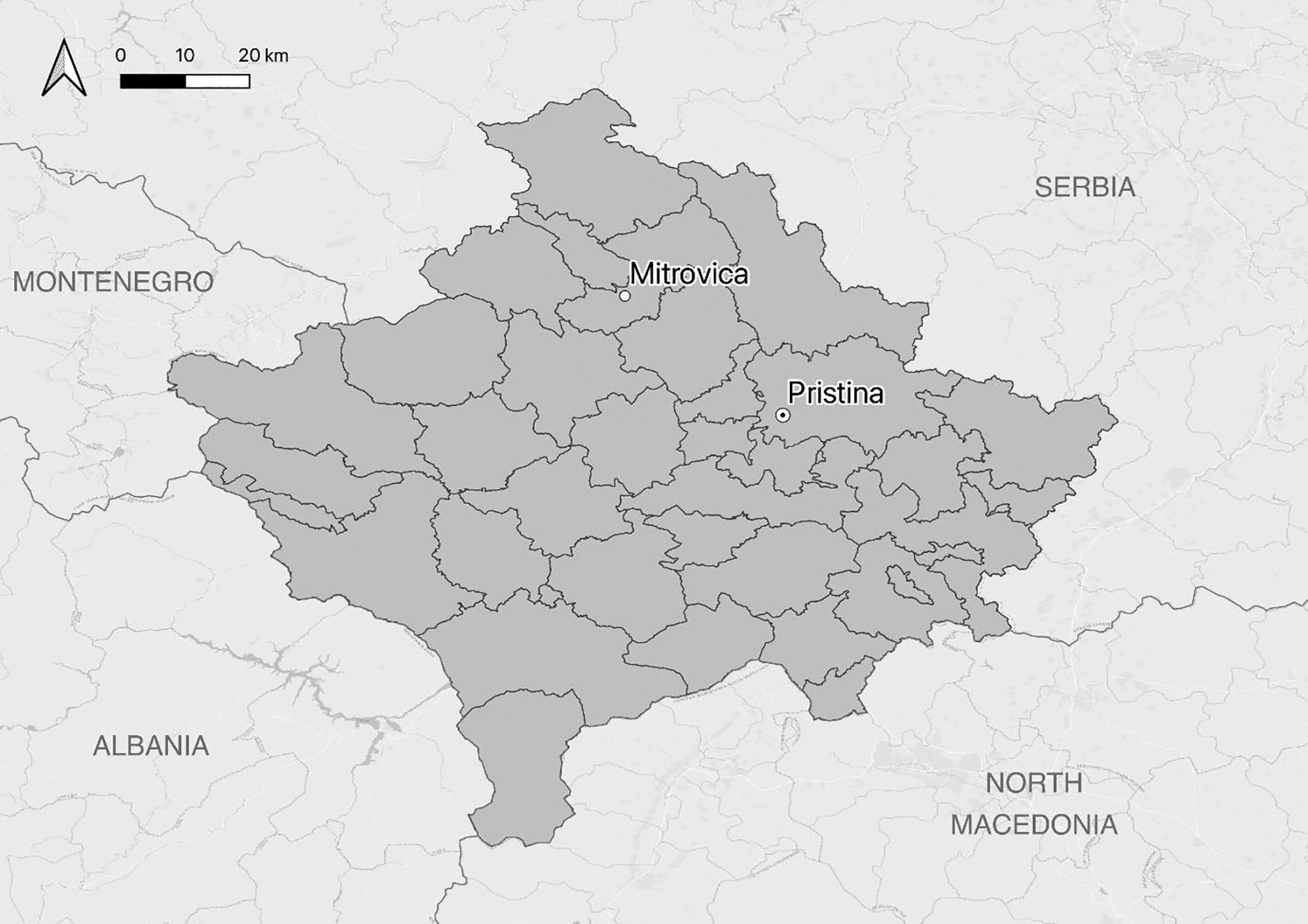
Once deployed, NATO forces set out to protect the Serb minority and retain some of Kosovo’s mixed nature. This endeavour concentrated in northern Kosovo, along Ibar in general and Mitrovica and its Main Bridge in particular – making the city central in the postwar period. NATO forces erected checkpoints along the Ibar river to divide the sides, prevent the KLA from moving further north, and end reprisal violence. This halted the refugee streams, but also divided the Serb-dominated north from the rest of Kosovo. 6 While the intention was to provide stability until the situation calmed, these checkpoints had much longer-term consequences than anticipated. Division was amplified by Serb ‘Bridge Watchers,’ who ‘sat on rooftops and in cafés near the riverbank, observed the bridges, and “discouraged” Albanians and Serbs from crossing’ (Gusic, 2019a: 156), frequent clashes between the groups, and the March 2004 violence against Serbs across Kosovo (Boyle, 2014).
Mitrovica subsequently remains politically, socially, and infrastructurally divided along the Ibar river (Gusic, 2019a). CRV has in turn continued to happen alongside these divisions. We coded 242 events of serious physical violence in the city since the war ended which can be considered conflict-related with different degrees of certainty.
7
While most events were non-fatal, the violence resulted in over 1400 people injured between 4 June 1999 and 31 December 2019. The data collection was based on a systematic search covering a wide range of Temporal distribution of events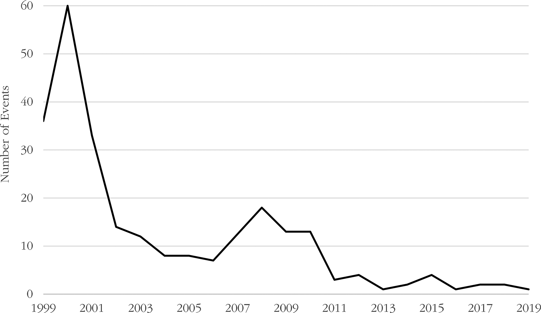
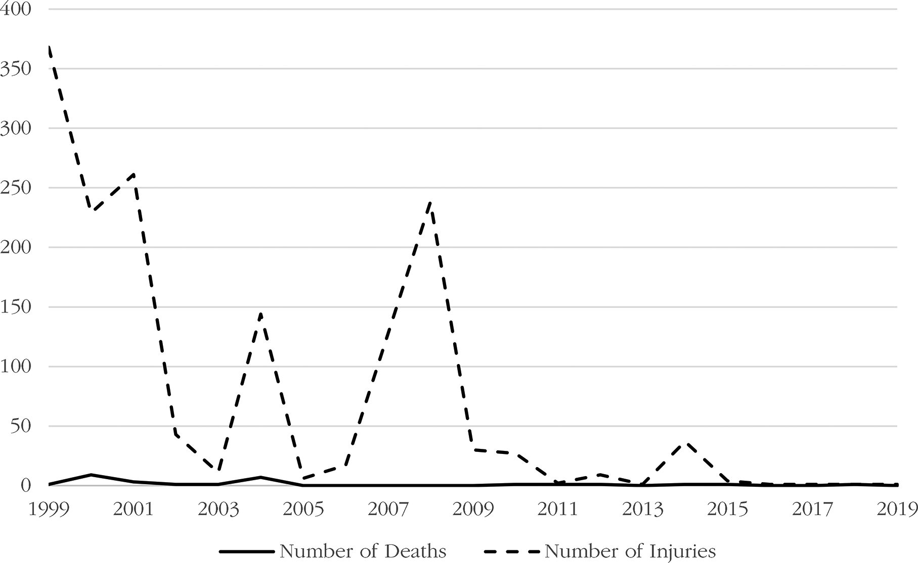
Our data underline a heavy concentration of violence during the first postwar years; more than half (53%) of all recorded events occurred between 1999 and 2001 (see Figure 2). While the no. of events remained quite low after 2002, an increase followed Kosovo’s declaration of independence in 2008. After 2011, the level of violence remained consistently below five events per year. Figure 3 displays the temporal distribution of injuries and deaths, again highlighting the significance of 1999–2001 and 2008. The spike in violence in 2008 traces back to riots following Kosovo’s declaration of independence. The removal of Serb protesters occupying the UN Court in Mitrovica set off clashes that injured more than 200 demonstrators and peacekeepers. The year 2004 also stands out, where although featuring only eight events, we recorded 144 injuries and seven deaths, mainly during violent riots in mid-March.
Out of 242 events, 44% were coded as occurring across Albanian–Serb conflict lines, and 31% featured direct involvement of external and/or local security forces. The most frequent type was attacks (events in which one side attacks the other; 57%), followed by clashes (violent interaction between two sides; 25%), riots/violent protests (mass demonstrations that turn violent; 12%), and assassinations/murders (the killing of people where circumstances suggest premeditation; 5%). 8
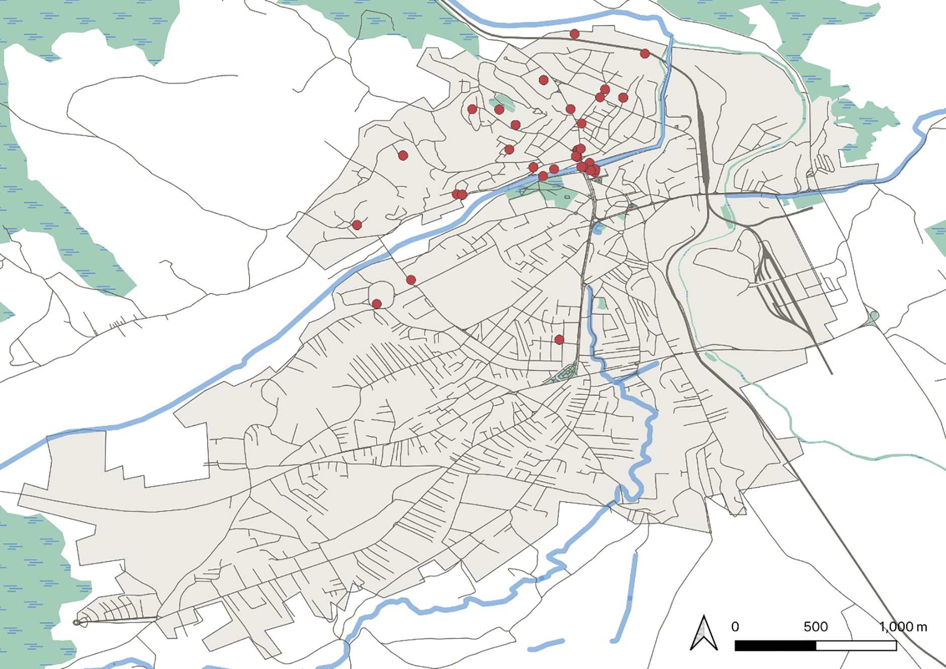
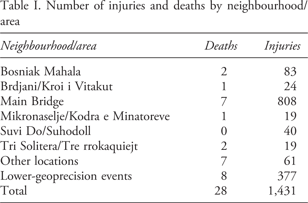
Out of 242 events, 150 occurred in Mitrovica north of Ibar, 84 took place in areas neither north nor south – for example, events coded at the Main Bridge – and only eight were recorded in Mitrovica south of Ibar (see Figure 4; note that some locations saw multiple events). Further examination of spatial clustering highlights that violence was concentrated in six neighbourhoods/areas (see Figure 5). Of the 114 events that are traceable to the neighbourhood level or a more precise location, 86% occurred in those six areas. The highest no. of events recorded in one area took place at the Main Bridge (41), followed by Suvi Do/Suhodoll (18), Bosniak Mahala (16), Brdjani/Kroi i Vitakut (10), Tri Solitera/Tre rrokaquiejt (8) and Mikronaselje/Kodra e Minatoreve (5). A comparison of the no. of deaths and injuries in these sites further solidifies these patterns (see Table I). The Main Bridge stands out: it not only records by far the highest no. of deaths and injuries, but the no. of injuries incurred there constituted more than half of the overall no. recorded. Our data thus underline the Main Bridge as a central location for violence in Mitrovica.
Temporal distribution of injuries and deaths
Location of events within Mitrovica
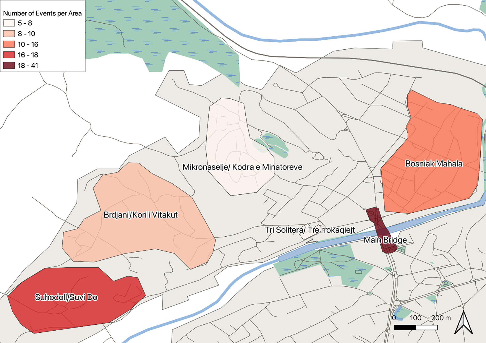
Spatial distribution of violent events in neighbourhoods/areas
Number of injuries and deaths by neighbourhood/area
Understanding the concentration of violence at the Main Bridge
As this article will demonstrate, no site in Mitrovica – or Kosovo – more single-handedly encapsulates continued Albanian–Serb tensions, Kosovo’s incomplete statebuilding process, or failed peacebuilding than the Main Bridge. Yet it was not always like this: ‘[before, it was] just pure infrastructure needed to cross the river’ (Pristina-based analyst, interview, 2015). The contemporary divisions in Mitrovica largely overlap – temporally and spatially – with the checkpoints erected in 1999. What was intended as a short-term solution created a long-term problem that still has a 24/7 security forces presence. Over the years the Main Bridge has housed barricades, roundabouts, walls, and even a park. Yet the result has been the same: Mitrovica’s division. [It’s a] Berlin wall. […] People here [come] to the bridge, and then from the bridge there is nothing, it is like coming to the abyss. ‘I have no need to go there’. I know people that since 1999 have not crossed, or maybe only two times because they had to (activist, interview, 2015). People […] have forgotten that there is a bridge, that there is a divided city […] the city ends at the bridge, 16 years of division, of this kind of politics have cemented this (local analyst, interview, 2015).
The material spatiality of the Main Bridge
Postwar Mitrovica has two city centres, one on each side of the Ibar river, which are frequented almost exclusively by Albanians or Serbs. But despite this bifurcation, the Main Bridge remains materially central. The reason is that the city’s infrastructural legacy – with cafés, cultural venues, and promenades gravitating towards Ibar – casts a long shadow. Mitrovica’s old city centre was built around the Main Bridge – it was where urban life happened (local EULEX official, interview, 2014) – while built environment is hard to change, often having long-term and hard-to-control effects (Massey, 2005; Gusic, 2019b). Mitrovica’s two postwar city centres consequently developed from the existing city centre rather than anew from the geographical centres of the two city halves. 9 While they are divided in the minds and lives of citizens – people tend to see them as ‘ours/theirs’ and frequent only one of them (Gusic, 2019a) – the new city centres are materially side-by-side, with only Ibar between them. The result of this disconnected proximity is that the Main Bridge constitutes a direct link between the ‘heartlands’ of the two sides with little room for buffer zones such as derelict, less important, or ambiguous (i.e. mixed) areas: ‘you cross the bridge and you are immediately in the centre. On both sides’ (activist, interview, 2015).
This material centrality – particularly its role in connecting the ‘heartlands’ – concentrates CRV to the Main Bridge through three dynamics. Firstly, the material link makes people feel more exposed to ‘the other’ at the bridge than in other parts of the city – which are not ‘heartlands,’ where the link is less direct, and where buffer zones are possible (local politician, interview, 2015). Especially Serbs – as the northern city centre is more concentrated to the Main Bridge – feel that the bridge’s materiality gives ‘the other’ direct access: There were incidents [after the war] when bombs were thrown at cafes. People are afraid that something similar will happen again. That 50 people will die (rule of law activist, interview, 2015). Especially if you are from here, and they know you, you do not have the liberty to go [across the bridge]. You do not know what awaits you. Earlier it was that when you crossed people would wait for you, beat you, stab you, shoot you (rule of law activist, interview, 2015).
This leads to the second dynamic through which the Main Bridge’s material centrality concentrates violence. The feeling of exposure around the bridge – caused by its materiality – makes especially Serbs
10
much more prone to resist efforts aimed to reconnect the city there than elsewhere (local historian, interview, 2015). Initiatives such as removing defensive architecture, opening the bridge to cars, or organizing shared events there are resisted because a closed bridge makes people feel safer: Some years ago, I bought an apartment 20 metres from the bridge, which at the time was blocked by concrete and stones. Ugly to see, but it gave some sense of safety […]. I did not feel pleasant [when they opened it]. My kids live nearby, they will go outside [and] you never know how someone will react, because for conflict to erupt here it is enough to be a member of the other ethnic community. Walkers you can control, but a vehicle can, technically speaking, generate much greater harm. Therefore, the closure of that bridge gives a certain amount of personal safety (father, interview, 2015). The bridge is by Serbs seen as a sort of protection. The fear is that if opened the Albanians will have the ability to come over (local lawyer, interview, 2015).
Bátora et al.’s (2020) survey data in Mitrovica confirm this notion. They find that for the majority of Serbs the Main Bridge represents the final frontier of physical security vis-à-vis ‘the other.’ It is thus unsurprising that most Serbs believe that opening the bridge for traffic would have negative security effects. The bridge materially constitutes a weak link in the defensive line towards ‘the other’ – it is where people feel most exposed – leading to resistance towards opening it up, which increases the likelihood of violence connected to such efforts. The events on 17 June 2014 are illustrative. That night the barricade on the Main Bridge had been unexpectedly removed. In the morning, with cars suddenly driving across the bridge, perplexed Serbs gathered, protesting against the barricade’s removal and confronting small groups of Albanians who crossed the bridge. Only when a new barricade was erected as the Peace Park later that day – again closing the bridge to cars – did people disperse (observation in 2014). While these confrontations did not cause any known injuries, they demonstrate how the Main Bridge’s material centrality generates both resistance to status quo changes and higher potential for violence. It was likely only a heavily escalated KP, EULEX, and KFOR presence that prevented serious violence that day (see Figures 6 and 7).
The third dynamic through which the Main Bridge’s materiality concentrates CRV is that its direct linking of the two city centres makes it an easy access point to those with malicious intent (OSCE official, interviews, 2014, 2015). Numerous examples suggest that confrontational crossings concentrate on the Main Bridge – that is, this is where people try to ‘push across’ and where such attempts are thwarted. In 2008, UN police prevented 5,000 Serb demonstrators from crossing the bridge by firing tear gas at them (event MIT08022201_01). In 2010, Turkey’s win over Serbia in basketball resulted in clashes as a group of Albanians tried to cross the bridge and was met with heavy resistance (event MIT10091101_00). In a similar event in 2003, 30 Albanians crossed the bridge and began throwing rocks at nearby Serbs. Soon a large group of Serbs gathered, forcing the Albanians to withdraw (event MIT03080101_00).
The perceived spatiality of the Main Bridge
The Main Bridge’s materiality promotes the concentration of violence there but does not explain it completely. Other bridges also link north and south but concentrate much less violence, while several mixed areas are relatively calm. The pedestrian bridge west of the Main Bridge – which connected (it is now broken) Tri Solitera/Tre rrokaquiejt and Mitrovica south of Ibar – and the Railway Bridge in the east are used by people from both sides (Bátora et al., 2020) while Bosniak Mahalla and other neighbourhoods in Mitrovica north of Ibar have Albanians and Serbs living side-by-side. To provide a fuller picture we turn to the perceived dimension of the bridge’s spatiality. Any discussion in Mitrovica about the war, current politics, or potential Albanian–Serb coexistence will eventually mention the Main Bridge and underline its symbolism. Everyone has an analysis of its postwar role, it evokes strong emotions, and is frequently used to illustrate arguments about the broader conflict. This symbolism distinguishes the Main Bridge from the other bridges, beyond the fact that it is more central and larger. The reasons for this symbolism are multiple. The Main Bridge was where the postwar delineation was enacted (UNMIK official, interview, 2014). It is also where so many clashes since have taken place and where protests for/against different conflict-related developments often centre. It has lastly been the spatial focus for ‘externals’ (politician, interview, 2022). Peacebuilding efforts focus on the bridge, its defensive architecture is attacked by Kosovo’s government, and Serbia’s EU accession process is linked to it: ‘it is no longer on the local level […] it is discussed between Brussels, Pristina, and Belgrade’ (local EULEX official, interview, 2014).
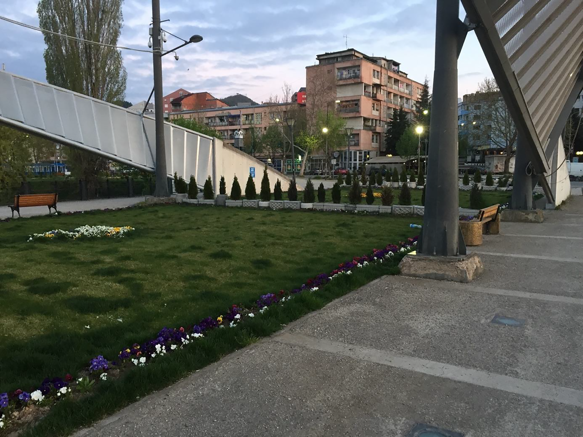
The bridge has subsequently become the symbol of divisions, the ongoing conflict, and how things have changed: ‘people see that bridge as a symbol of non-peace and tension. Not as a symbol of connection but of division’ (rule of law activist, interview, 2015). It symbolizes past violence, trauma, and – in extension – the impossibility of coexistence (politician, interview, 2015; see also Bátora et al., 2020). The bridge also symbolizes the state of things in Mitrovica (and Kosovo) – for example, the current power balance, future trajectory, and who any changes will benefit. Take integration of Mitrovica north of Ibar (and the rest of northern Kosovo) into Kosovar institutions. On this issue – which The barricade. Photo by Gusic in 2011 The Peace Park. ‘It is nicer now, but it is still a form of barricade’ (local EULEX official, interview, 2014). Photo by Gusic in 2014 [It] is not that important [for traffic]. You can reach the north through four, five roads other than the bridge. But this bridge is the problem because it had constant tension and people are afraid (politician, interview, 2015). Albanians cross every day, even on the Main Bridge if they are pedestrians, and on the other bridges by car […] but that barricade on the bridge is a symbol that Albanians will not cross in any great numbers […] that Albanians should not come to the north (rule of law activist, interview, 2015).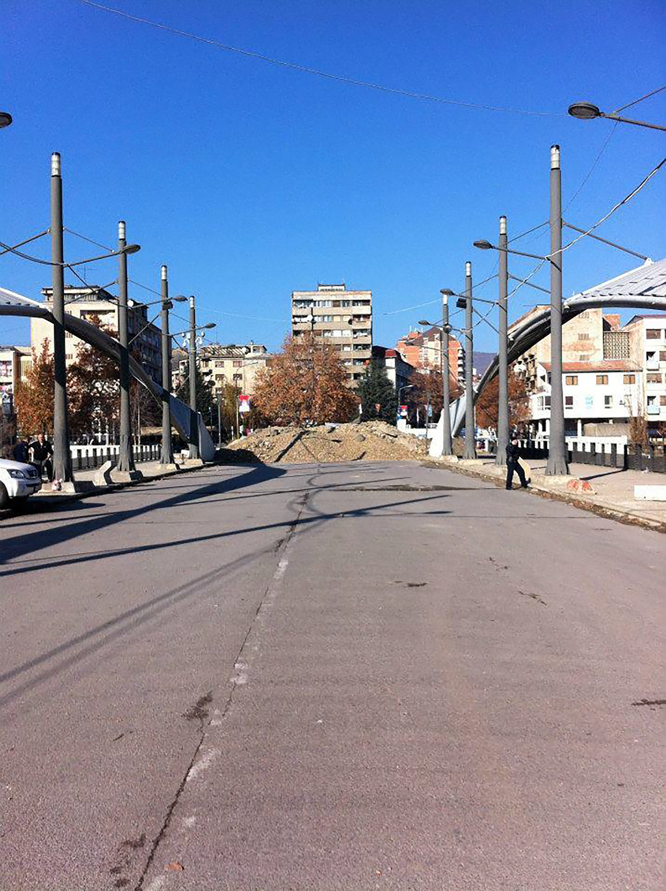
This symbolism concentrates violence through two dynamics. Firstly, being an indicator of the overall situation has made the bridge the site for protests relating to wider developments. Protests for/against integration, Belgrade’s influence in Kosovo, violence across conflict lines, and so on are organized on the Main Bridge, even if the reason is elsewhere: ‘every time something happens in Mitrovica people go to that bridge [even if] there are other bridges as well. The [Main] Bridge is very politicized’ (civil society leader, interview, 2011). These protests often lead to violence, which the protests both leading to the creation of the barricade on the bridge (in 2011) and related to its reinsertion (in 2014) illustrate. The barricade’s emergence had nothing to do with the bridge (or Mitrovica) but was a protest against integration, triggered by Kosovo’s special police taking over Serb-controlled checkpoints between Serbia and Kosovo (Gusic, 2019a): [The barricades are a] protest towards what is decided above our heads. We do not want to join a south that does not respect the human rights of Serbs, [that does] not arrest Albanians who have committed crimes against Serbs. […]. We need to keep them out, to keep Serbian institutions, to keep this Serbia, because if we do not […] people will flee (activist, interview, 2011).
The barricade’s establishment in 2011 did not lead to much violence, but only because security forces managed to keep it at bay, preventing Albanians from removing it and not removing it themselves as ‘it would be very dangerous’ (NATO official, interview, 2011). However, in 2014, when the Peace Park was built, Albanian protests led to considerable violence when clashing with security forces (see Gusic, 2019a) (see Figures 8 and 9).
The patterns of violence in our dataset also indicate that the Main Bridge’s symbolism is partly why CRV concentrates there. Violence at the bridge correlates with major politicized events in Mitrovica and beyond, while the types of violence usually associated with symbolic events (e.g. riots) are particularly concentrated there. Compared to riots in other parts of Mitrovica, riots at the bridge were also especially violent, resulting in approximately 246 injuries and six deaths.
This connects to the other dynamic through which the Main Bridge’s symbolism concentrates violence: events that do happen there tend to be amplified, and reactions are similarly intensified. ‘Something happens at the bridge and then we are back [to war]’ (local lawyer, interview, 2015). This is because events on the Main Bridge generate insecurity and remind people of past trauma: Most shit went down there. That is why it became a symbol. […] A lot of people were killed there. Hurt. Lost an eye, a kidney. […] And when someone has a need for trouble, they just light a match. [It is a] critical spot which in case of need, with very little petrol, you can burn everything to hell (activist, interview, 2015). The worst thing is that things can go up in flames in a second. […] You can wake up and hear a war outside your window (local EULEX official, interview, 2015).
The lived spatiality of the Main Bridge
The Main Bridge’s perceived dimension provides additional insights to the concentration of violence there, but there are still other aspects to it. We lastly explore its The bridge in 2022, still barricaded and patrolled. Photo by Gusic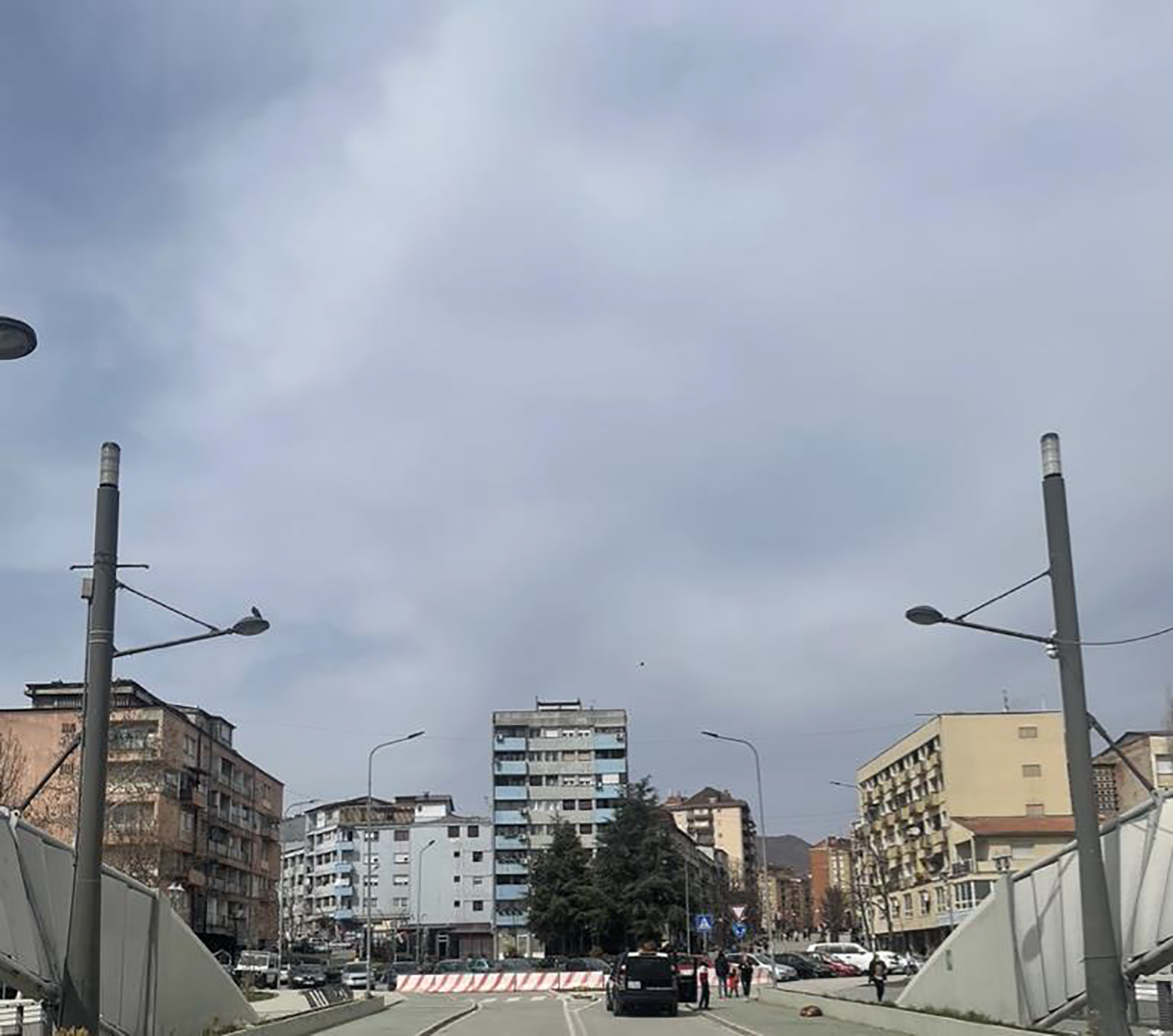
Often it is the other bridges that are used to cross the Ibar river or alternative sites are found for interaction. Serbs tend to use the Railway Bridge to go shopping in the south as it leads to several shopping malls – for example, 54% of Serbs indicate that they use it for grocery shopping – and it also serves as the main path for Serbs from the rest of Kosovo studying at the university in the north (professor, interview, 2022; Bátora et al., 2020). Albanians who live in Mitrovica north of Ibar, but work or use services in the southern part of the city, also often use the other bridges to cross back and forth (OSCE official, interview, 2014). The main intersection in Bosniak Mahalla is used to switch taxis when going between the two sides, even if the Main Bridge would be the more convenient solution. 11 Although the Main Bridge is a nice place people tend to socialize elsewhere while trade across conflict lines happens in Bosniak Mahalla rather than around the Main Bridge (local European Union Special Representative (EUSR) official, interview, 2011).
The reasons for this changed way of living – or rather: not living – the Main Bridge are many. Its securitization by different security forces, concentration of ‘Bridge Watchers’ activities (and those of other ethnonationalist groups), negative symbolism, violent history, and personal experience means that the bridge is not the ideal location for interactions unrelated to the conflict. To this end ‘a great per cent of people [in Mitrovica] have not crossed that bridge for 15–16 years’ (rule of law activist, interview, 2014). Another interviewee noted: Protests against the barricade. Photo by Gusic in 2014 My apartment is [near the bridge] but I do not take [my kids] there, I am afraid to let them play there unsupervised because of incidents that constantly happen. Incidents that are less intense than before, but still exist. […] The tensions are still too big (local UNDP official, interview, 2015). The bridges are very watched, in order to see who is crossing and when, and then people are more afraid to cross (civil society leader, interview, 2011). I was […] wandering around north Mitrovica [near the bridge]. I took out my tape recorder and started interviewing […]. Then I heard some cars and started walking down the bridge. Somebody had already called some people and told them there is this guy asking questions […]. Maybe I walked across the bridge once [since then] but if I could I drove [using other bridges] (UNMIK official, interview, 2015).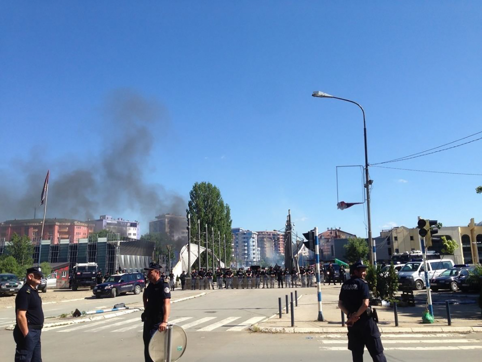
Conclusions
Our analysis of two unique sets of data allows us to draw several important conclusions. Our systematic data on CRV in postwar Mitrovica underline that this violence concentrated – and amplified – at the Main Bridge. Through relational space we explored multiple reasons for its role in the contestation over Mitrovica and why CRV concentrated there. Based on in-depth fieldwork, we highlighted how the bridge’s material, perceived, and lived dimensions all contribute to explaining this concentration.
The unequal distribution of violence in Mitrovica demonstrates that the city contains flashpoints of violence that make everyday life dangerous in the city and beyond. Yet it also indicates that there are sites which are comparatively spared from violence and which enable coexistence (cf. Jarstad & Segall, 2019; Bátora et al., 2020; Gusic, 2022). The analytical framework presented here can likely help us to understand these patterns as well. Future research could explore why violence does not concentrate at other sites, and to what degree this is explained by material, perceived, and lived dimensions of space. The concentration of CRV on the Main Bridge seems to have much to do with the bridge itself. This insight, however, does not suggest that peacebuilding should be completely refocused to it, as this would entail treating the symptoms rather than the causes. Yet the bridge nevertheless demonstrates the longevity and robustness of space, a reality we must recognize to move beyond the shadow of entrenched spatial problems.
We also add to existing research on violence in postwar cities more broadly. Our finding that CRV in Mitrovica concentrates in certain places is in line with studies by Bollens (1999, 2018), Calame & Charlesworth (2009), Pullan & Baillie (2013), Gusic (2019a), and others. This underlines that peacebuilding needs not only to be urbanized – that is, adapted to the city (Wennmann & Jütersonke 2019) – but also sensitized to intra-urban differences. Our analysis resonates with Bátora et al. (2020) who argue that different spaces take on different institutional logics, which lead to peaceful or confrontational interactions. By considering the relationality inherent in such developments, we contribute additional insight into how these institutional logics arise. The findings are also in line with the argument that violence risks are highest where macro frontlines intersect with micro-struggles (Esser, 2009; Davis & de Duren, 2011; Pullan & Baillie, 2013; Björkdahl & Mannergren Selimovic, 2016). The Main Bridge clearly epitomizes the intertwined conflicts between different groups in the city, between Serbia and Kosovo, and between local, regional, and global interests. To the broader literature on postwar violence, which has focused on the role of peacekeeping and security provision (Bara, 2020), former commanders (Themnér, 2011) and strategic targeting and elite incentives (Boyle, 2010; Barron, 2019), we contribute an attention to how everyday spatialities can deepen our understanding of micro-level patterns of violence. While the specific drivers of violence and configuration of space differ across contexts, the analytical lens we employ could be extended to other cases to provide a deeper understanding of why postwar violence clusters in specific geographical sites.
Finally, our analysis underscores the analytic utility of fine-grained systematic data on violence in postwar cities. It represents the first study exploring CRV in a postwar city using systematic data on violent events geocoded with maximum possible precision. Such data open up new research avenues using different forms of spatial and correlational analyses. While high levels of CRV are a well-known condition in many postwar cities, fine-grained data enable nuanced analysis of where, when, how, and why violence concentrates, as well as why some sites and times are unaffected. Our approach was to use such data to systematically map patterns of violence, and then explore the causes of these patterns. In-depth fieldwork was key to understanding why the Main Bridge is central to violence distribution in Mitrovica. The lack of systematic data, however, would have left us in a state of ignorance regarding what sites were most exposed. Our findings thus underline the value of combining systematic data on the patterns of CRV with in-depth exploration into its underlying dynamics to generate insights that both resonate with messy everyday realities and are comparable with other cases. Also, a similar analytical approach could arguably help shed light on the uneven distribution of violence in other postwar cities.
Footnotes
Acknowledgements
We are grateful to Sebastian van Baalen, Nguyen Ha, Brendan Murtagh, and to the editors and reviewers for constructive comments on this article.
Funding
The authors received the following financial support for the research, authorship, and/or publication of this article: The research was funded by the Swedish Research Council (2019-02563; 2019-03870).