
Abstract
The history of science in islands is not a well worked out discipline. This article offers the first thorough historical account of astronomical activities at Madeira, from the discovery of the uninhabited island in the fifteenth century (600 years ago), through its establishment as an astronomical observatory (300 years ago) and up to the recent past.
Historical astronomy at Madeira
By the early 15th century astronomy had become consolidated as an important tool for the Portuguese exploration of the seas and the consequent expansion of the country, which Saraiva has described as a “national entrepeneurship.” 1 Henry “the navigator,” son of king John I, was so in love with the science of astronomy that he studied it thoroughly. 2 In 1420, the discovery of the island of Madeira was officially announced, though there remain disputes about whether the island may have been visited earlier. The newly-founded city of Funchal became the preferred place where Portuguese sailors and pilots learnt modern techniques 3 (e.g. astronomy) and perfected high seas sailing that would, soon, take them along the African, Asiatic, and American coasts.
As a reaction to the attack of French pirates on the previous year, 4 in 1567 the Portuguese Navy arrived in force to the island of Madeira. With it came three Jesuits, who (with a few more), only 3 years later, 5 established their first college in the island, at the exact place (and building) that the University of Madeira (UMa) occupies today. It was at its tower, when on his way to Louisiana and bringing his own equipment, that the French Jesuit Antoine-François Laval inaugurated the Astronomical Observatory of Funchal in April 1720. This also became the first astronomical observatory in Portugal. From the astronomical observations there conducted, Laval managed to correct several errors that existed in astronomical tables. 6 The last known user of the Observatory was a resident British amateur (and medical doctor), 7 Thomas Heberden, who used it from 1763 to 1768. 8 His longitude measurements were good enough to deserve publishing in the reputed journal Philosophical Transactions of the Royal Society. 9
In order to use (positional) astronomy for improving nautical charts (adding longitude), Gabriel De Bory led an expedition from France (Brest). One of their objectives was Madeira, a “mountain crossed by a large number of precipices,” 10 where they arrived by Christmas 1753. De Bory observed from a house at the “center of the ‘croissant’ that the shore of the sea forms” 11 and, indeed, the nautical charts precision was much improved (with the first longitude measurement made at Funchal; and a much improved error in latitude from the almost two-arc minutes from Laval). British astronomers frequently visited Madeira, such as John Crosley, in 1801, who made astronomical observations all the way from Portsmouth to Funchal, including measurements of the latitude and longitude of this city. 12 In 1822, Johann Ludwig Tiarks came with, no less than, “14 chronometers, by order of the British Government, in order to measure the longitude difference between Greenwich and Funchal.” 13 He failed to do so with the required high precision 14 but, in the same year, the winner of the (in)famous Longitude Prize, in the total of 100 guineas, was Franks, for his measurements of the longitude of Madeira. 15 Also by then (from October 1822 to January 1823), without any astronomical observatory in the island of Madeira, Thomas Edward Bowdish used, for his astronomical observations, “the turret of Mr. Veitch’s house in Funchal (154 feet above the level of the sea).” 16 Veitch was the British Consul in Funchal.
Taking advantage “of the transparency of the Madeira air”
17
during one of the best Mars oppositions ever, giving the planet an apparent size of 24 arcseconds,” amateur astronomer (but fellow of the Royal Astronomical Society (RAS)
18
) and professional artist Nathaniel Everett Green came to Madeira in 1877
19
and observed Mars from 19th August until 4th October, in the first month from a site in Funchal 360 m-high while, for the remaining period, higher up (660 m)
20
at a “quinta” in Camacha that belonged to the Hinton family (and where, only 2 years earlier, the first football match in Portugal took place). “It would be difficult to exaggerate the keen map-like appearance of the planet.” A total of 41 drawings “were made direct from the telescope” and, not seeing them from Madeira, Green dared to write that the remarkable dark canals so strongly depicted in the maps of Professor Schiaparilli [were due to] a great tendency to prolong [any] imperfectly seen dark form into a point or a line [. . .] In [Professor Shiaparilli] view the light portions of the planet’s disk are crossed by various dark canals, which certainly were invisible at Madeira.
21
Four years after Green (from May to July in 1881), Charles Piazzi Smyth came to the island of Madeira and made most relevant spectroscopic observations of the Sun from a hotel in Quinta do Carvalho (Funchal): “and behold, there was no haze that was not resolvable into the most exquisitively sharp and well defined lines” 22 (he lamented not having brought his best diffraction gratings). 23 He discovered oxygen lines but his most relevant result was to split, for the first time, the difficult line of the “newly observed mysterious substance [. . .] provisionally now called ‘Helium’” 24 from another of iron (Figure 1). 25 By then, only spectroscopists knew the new element, discovered by Lockyer just 13 years before, during a solar eclipse, 26 but “called [that particular] green line they saw everywhere an iron line.” 27
Piazzi Smyth spectroscopic observations in Madeira were the first to split the helium line (at left) from an iron line (at right): “there were really two lines on that place, but [too] very close together.”
W. Anderson observed a Leonid meteor shower from Funchal (Quinta Cuibem) on the 14th November 1896 and managed to count “them [. . .] noting the times of their appearance.” 28 His results were published in the Monthly Notices of the Royal Astronomical Society (MNRAS). In 1924, Ernest Anthony Lonsdale Attkins came to Madeira to observe Mars in its best opposition since the “Green year” of 1877, from the Monte Palace Hotel (Funchal). There he made “first class images” of Mars 29 easily detecting dust covering some parts of the surface and a very well-defined polar cap. His work was good enough to grant him fellowship of the RAS in 1926.
From 1917 and during a few years, two subjects of astronomy were taught in a 2-year course in a Pilot School at Funchal: “General Astronomy” and “Astronomical Navigation.” 30 In 1918, Gago Coutinho invented the artificial horizon bubble sextant, tested in a 1921 flight from Lisbon to Funchal. The following year, with Sacadura Cabral, he was the first to cross the Southern Atlantic by plane, using the stars and the Sun for navigation. 31
“In 1892, an American mission [was in Madeira] measuring astronomical latitudes and longitudes” 32 by triangulation between two landmarks (at Paul da Serra and Forte de São Tiago—Funchal). Similar measurements were later made (1914) by a Portuguese government division; those were improved in 1936–1938 by the Hydrographic Mission thanks to eight new landmarks 33 (e.g. Ponta do Pargo—Figure 2). To complement the measurements, “15 double stars of the Eichelberger catalogue” were observed, in order to measure latitudes with an error “inferior to 0.1 arcseconds” and 12 stars to measure the longitude, with the help of local and distant chronometers. 34
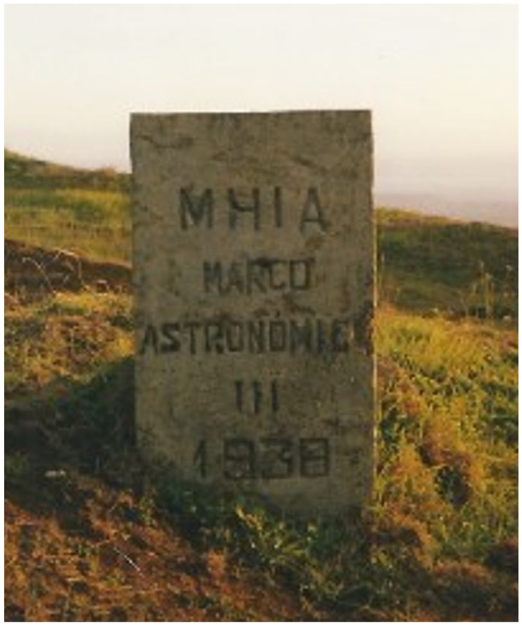
The 66 years-old (and misplaced) astronomical landmark (“Marco Astronómico”) of Ponta do Pargo in 2004. MHIA means “Missão Hidrográfica das Ilhas Adjacentes” (Hydrographic Mission of the Adjacent Islands—the Azores and Madeira Archipelagos).
The northern hemisphere observatory and Madeira
New organizations
In 1962 the European Southern Observatory (ESO) was established (with five countries) with the pioneering objective of placing a very large observatory in the Southern Hemisphere (initially, the south of Africa was explored; but Chile (La Silla, 2400 m-high) got it first; other sites in Chile were later accessed by ESO—Cerro Paranal, Cerro Armazones 35 ). As for Britain, that was the time when its two main Royal Observatories (the Royal Greenwich Observatory, RGO, and the Royal Observatory of Edinburgh, ROE) were revitalized with dynamic directors, 36 a substantial increase of staff and, especially, by both getting under the umbrella of the Science Research Council (SRC) 37 “set up in 1965 as part of a complete reorganization of (UK) government science.” 38
Harry Plaskett, in 1946, then President of the RAS, had noted that “much of our telescopic equipment is inadequate, if not obsolescent” 39 and proposed a large telescope, to be called Isaac Newton Telescope (INT), 40 the name suggested by Sydney Chapman. 41 The contract for a 2.5 m INT was signed in 1959, and the telescope was to be placed at Herstmonceux, Sussex, “the best possible site in the UK,” 42 “even if the astronomer does have to lie waiting for the clouds to break [there].” 43 The RGO had definitively moved into there just the year before. The INT inauguration was only in 1967, 44 right when “building a large telescope in the British Isles began to seem less appropriate.” 45
The Joint Organization for Solar Observations (JOSO) was founded in 1968–1969 46 with the aim of looking for sites for a large solar telescope. Until 1974 about 40 Mediterranean and Atlantic coastal sites were considered, 47 initially favoring low-level oceanic sites, ideally lake-like, such as “well detached” small sandy islands, where turbulence would be minimal (“sea breeze concept”): Madeira and Selvagem Pequena islands were studied, the latter in 1971. 48 However, Selvagem Pequena “island was imbedded in large scale atmospheric inhomogeneities [and] the seeing observed [. . .] was not satisfying and the sky was frequently overcast” 49 (Appendix). In the following year, Rob Hammerschlag studied Pico do Areeiro (1818 m-high), the third highest peak in the island of Madeira, but the JOSO team was on the wrong side of the island (south) and laminar flow, 50 something that would become standard pre-check a couple of years later, did not exist there. On the contrary, “large thermal disturbances [. . .] up to 80 m above; [. . .] irregular air streams [and being] frequently imbedded in the inversion layer” 51 ruled out the site (and, in fact, Madeira).
A major British observatory in the northern hemisphere
It was well known, right upon its inauguration in 1967, that the INT in British soil was doomed to failure more often than otherwise. 52 It was RAS president Bernard Lovell himself, in 1970, who said that Britain had, not only, the INT (“the largest telescope in Britain [since] the one built by Herschel in 1785”), 53 but also its two major observatories (ROE and RGO) all misplaced: the best site in Europe, as regards seeing, should be found and a large telescope placed there. 54 Lovell went further, warning that they were “at important crossroads in the development of British astronomy” due to too much money available! (“equivalent in kind to the construction of three 150-inch optical telescopes per annum”) Spending it well was a must, but all astronomers had to be united by common objectives instead of “quarrelling amongst themselves.” Otherwise, the SRC could decrease the amount of support. 55
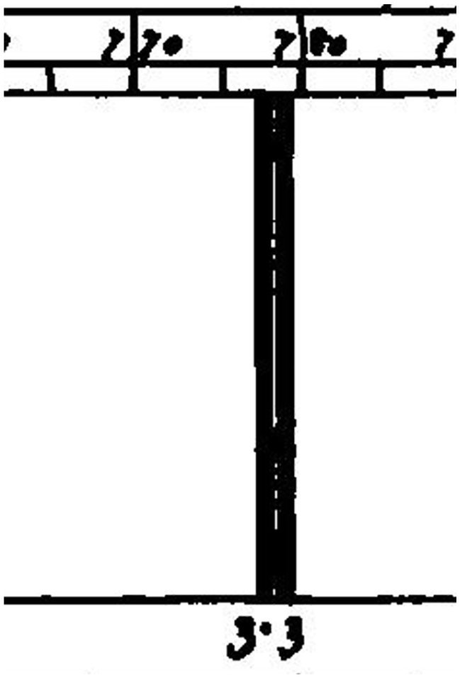
Indeed, just the year before (1969), the SRC established the Northern Hemisphere Review Committee (NHRC), 56 led by Fred Hoyle, 57 who had the first meeting on the 28th January of that year. 58 With 4 million pounds available, 59 a Northern Hemisphere Observatory (NHO) “national facility,” 60 first suggested in 1967 by Brück, Astronomer Royal for Scotland, 61 should be placed in 1974–1975 in one of three sites to be tested under a Site Testing Project 62 : (i) Castelgrande, Il Passo (Italy); (ii) Calar Alto (southeast mainland Spain); (iii) Izaña (Tenerife, Canary Islands, Spain). 63 “J.B. Alexander of RGO should supervise the necessary site testing” 64 : he started by visiting La Palma in April 1970. 65 In the summer of 1970, “three (Polaris trail telescopes) PTTs [. . .] based on Walker’s model” 66 (Appendix) were built at the ROE 67 : “three identical sets of equipment” 68 for seeing measurements at each site, that were intended to be carried out simultaneously for a full year, 69 several times each night. 70 The NHRC had its last meeting in September 1970. 71 In the beginning of 1971 72 staff training started at the RGO (the ROE was asked to provide the junior observing staff while the RGO provided the project leader). 73 The idea was to have teams of two observers at each site, with a third “resting” between shifts. 74 To the total of nine, a 10th would be added for general support and data reduction at the home-base (ROE, as suggested by Brück). 75 Early in 1971, La Palma had a “brief inspection of conditions” as a possible alternative to Izaña, since “the increasing amount of light” 76 in Tenerife was becoming a serious problem. 77 Alexander went as far as prophesizing that “the ideal solution may be an international observatory site on the island of La Palma.” 78
Meanwhile, the ROE was found more suitable as Site Testing Project headquarters but John Alexander, who “should be temporarily transferred to ROE” 79 did not make the move. “After a year of rather slow progress the RGO withdrew from the project and [still] in 1971 [McInnes] was appointed as project leader.” 80 Merle Walker (Appendix) was invited as project consultant. Staff training took place in August of that year at the ROE, with junior members such as Malcolm Hartley and Alan Pickup 81 being coordinated by senior ones at each site: Titterington (Italy), Alexander (mainland Spain), and McInnes (Tenerife). 82 The observing teams were completed by the youngest members (“temporary assistants”), recruited from public calls (in newspapers), mostly amateur astronomers and students 83 of which “the ROE teams made considerable use [. . .] some of whom [taking] a year away from their studies.” 84
Malcolm Hartley was joined by Philip Henley and P.D. Pedrick at Izaña (studied for 11 months in 1972) 85 ; La Palma had a session in June-September 1972, 86 although the formal scientific tests 87 only covered August–September. 88 La Palma had “a distinct advantage over Tenerife as far as astronomical seeing and level of artificial lighting were concerned.” 89 So, it got immediate visits (still in 1972) from respectable seniors such as Francis Graham-Smith and Merle Walker, with McInnes by their side. 90
Madeira was mentioned as a possible alternative to the Canaries if the Saharan dust became much of a problem there (estimated to affect 10% of Canarian nights). 91 Cape Vert was later ruled out for this reason. 92 (We now know Madeira is 3–4 times less affected by dust than the Canaries). 93 Alan Pickup got Thomas Gough and Crispin Heath as mates at Calar Alto where trouble came soon, with “permission to set up this station [. . .] refused on the grounds that sufficient information was already available from the German work.” 94 There were also “political difficulties,” 95 first reported in February 1972 that, at the very least, influenced the denial. These remained in November of the same year, when Portuguese Cape Vert became a replacement hypothesis. 96 In 1972–1973 the “political problems of placing British telescopes [in the Canary Islands] were considered to be insuperable” 97 : the British observers had to leave La Palma 98 and, not much later, Tenerife, “while diplomatic activity via the British Embassy in Madrid attempted to obtain formal permission for their activities.” 99 “By November 1972 it became clear that [the observers] would have to leave Tenerife mostly due to political factors.” 100
Italy became a mirage, since Castelgrande tests made by the ROE in 1972 “were not particularly encouraging” 101 : “10 months [of] continuous night-time observations [showed] that the clear sky conditions over southern Italy were not sufficiently good for further consideration.” 102 So, in the summer of 1973 103 “new” sites had to be considered such as Hawaii, Madeira, and Cape Vert 104 (the latter two in Portugal). After studies made there in May–July 1973, Cape Vert was ruled out (too much effect of the Saharan dust). Hawaii was kept on, also after a short visit (July–August 1973). Madeira came next. . .
The NHO and Madeira
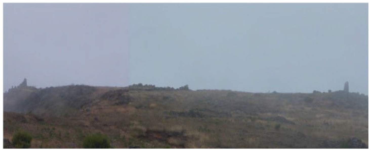
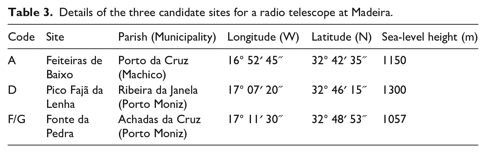
Both the JOSO and Merle Walker published an initial list of potentially good astronomical sites in the Mediterranean and the Atlantic, which included Madeira 105 and this is why the NHO backup list 106 includes Pico Ruivo de Santana (1862 m-high) and Encumeada Alta 107 (1784 m-high), which are close to each other. Topographically, Encumeada Alta is the ideal place at Madeira: as in La Palma the “terrain to the north presents a smooth and convex surface to the prevailing wind” 108 (Figures 3–5).
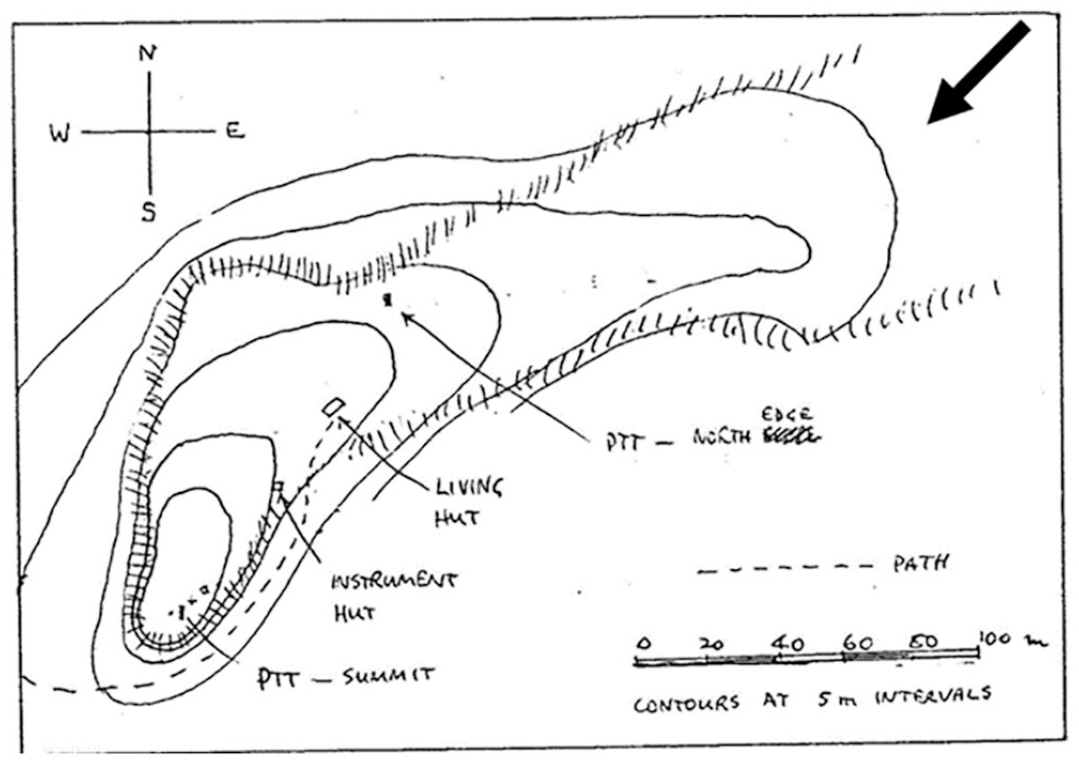
5 m contour levels of the Encumeada Alta plateau. Near the summit (bottom left) a first PTT was placed (the “south tower”) and, later, a “north tower” PTT post was also established. The location of the two huts is indicated, as well as the path to Casa de Abrigo (of Pico Ruivo), towards left, that also leads into Pico Ruivo de Santana, the highest peak in Madeira. The ideal spot to measure seeing is, possibly, at the NE corner of the plateau, since that is from where the winds usually come from (arrow). However, this area was never studied.
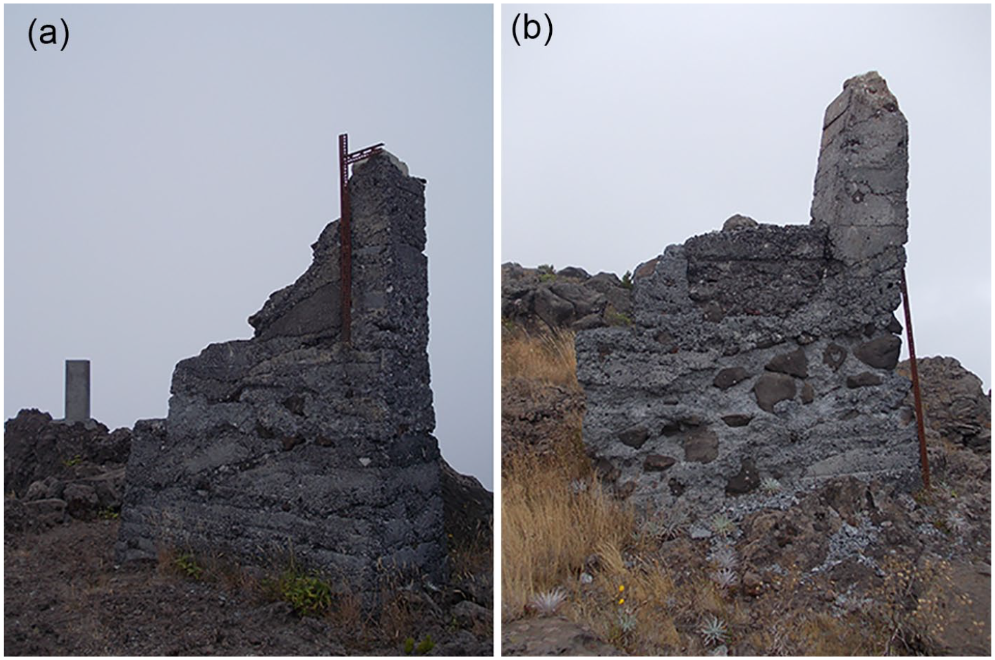
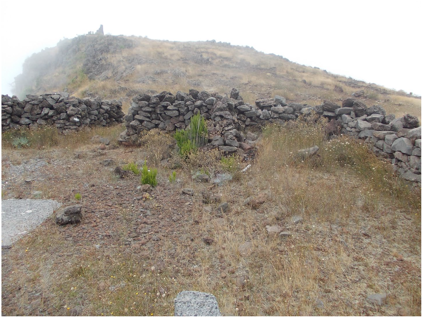
(a) The Encumeada Alta “south tower” in 2012. On the left, the geodetic marker of the 1784 m altitude at Encumeada Alta is seen. (b) The “north tower”. See Figure 3.
Indeed, we know that at Madeira two-thirds of the year the winds blow from a “broad” north (N, NE, and NW) giving the island a well-defined inversion layer (above which the air is clean and dry) with base below 1.8 km in altitude, a few months per year as low as a few hundred meters. The altitude of the top of the layer sits, most of the year, at 1.0–2.4 km. 109 This would make Madeira a top-world class site were it not for the relatively low altitude of even its highest peak which, at 1.9 km in altitude, is not quite high enough to be above the inversion layer for a good fraction of the year (and rarely so during the winter months). 110
After all staff and equipment (including a Land Rover) were transferred from Cape Vert, Pico Ruivo de Santana was studied from 16th to 25th August 1973 by A.G. Barrett and Crispin Heath with a PTT “mounted on a metal framework that was then loaded with rocks to provide stability.” 111 This site has a very convenient location, being served by a house at its base (10 minutes walk). This “Casa de Abrigo,” built in 1939, 112 although without electricity, did work well as a mountain hut, with some comfort such as bedding and water heating (through a boiler fed by wood). In addition, it was actually staffed most of the year. However, Pico Ruivo itself is quite small, had frequent visits by tourists and would be “a logistic challenge.” 113
Thus, Encumeada Alta was studied in alternation with Pico Ruivo until October 14th: 2 months of good results were enough to bring to the island Merle Walker, together with Bennet McInnes and Philip Henley, from the 9th to the 13th of October. 114 After this final full-week study, Pico Ruivo was “ruled out as a possible observatory site because this scenic region is one of the tourist attractions of the island” 115 and, thus, the PTT was definitively placed at Encumeada Alta where “tests should, of course, [have been] made of the seeing conditions simultaneously at different points over the proposed area in order to verify that all of the area of the proposed site is of equal quality and that no local effects exist.” 116 This did not quite happen and the worst place in Encumeada Alta was actually picked to start the measurements. The story follows. . .
The observations were paused while everybody was involved building huts at Encumeada Alta (one for accommodation, another for the instruments) during the full month of December. 117 The main hut was designed by Malcolm Hartley and it was, in fact, the prototype of the hut built 1 year later at La Palma, “wooden huts, like those in Madeira” 118 (Figures 6 and 7). When off-duty (2–5 days) the observers would go for a rest in the city of Funchal. 119
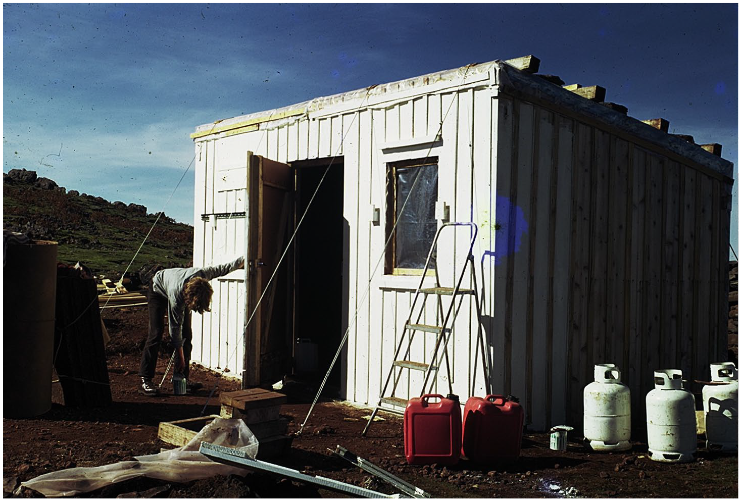
The hut at Encumeada Alta being finished up (painting) by Patrick Murray in 1973. Set up on a concrete base, four steel cables hold it to the ground; stones on the roof prevented this to fly away during storms. ©Philip Henley.
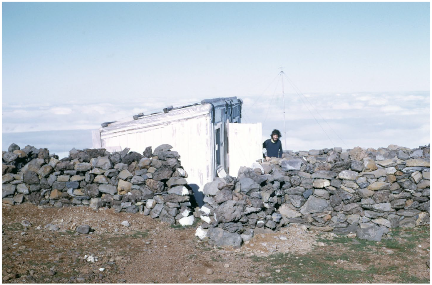
A surrounding stone wall granted further protection to the hut against strong winds, especially towards north/northeast. Paul Cass is seen on the photo. ©Hillary Sillitto.
Observations were resumed in January 1974 and were taken, continuously, 120 until February 1975 (seeing) while cloud cover was measured two extra months. 121 Philip Henley was local leader until July 1974, from then on replaced by Paul Cass. 122 In February 1974, not much after the observers finally filled up the south tower with concrete, the observations were indicating too much turbulence (of course. . . see Figure 3) and a new sub-site at Encumeada Alta was chosen with a “north tower” built, from March to May 1974. This was only 20 m lower than the other tower but much better topographically (convex mountain slope facing the dominant winds). For a while (May–November 1974), with Italy definitively out of the list and the Canaries not yet back on track, two PTTs were actually available at Encumeada Alta (one was Walker’s) 123 and the two sub-sites were studied simultaneously. 124 From December 1974 the observations were conducted from the north tower alone (confirmed as the best from the previous 6 months). 125
Until April 1975, Madeira had (usually) three simultaneous observers on the island, the last trio being Martin Berkeley, Andrew Carter, and Derek Andrews. The latter left Madeira in the end of April and it was with only a duo on the island (Martin Berkeley and Andrew Carter) that the tragic death of 18-year old Andrew happened on 8th May. 126 This is the official date, as posted in the obituary by The Scotsman 127 and, in fact, as inferred from what the only witness (Martin Berkeley) said: by 3 am he realized Andrew had an accident (fell from a cliff), was injured and, so, went calling for help at Areeiro (a 3-hour walk away). The firemen only arrived at the site by 10 am and found Andrew dead (Figure 8). 128 The autopsy, however, actually timed the death at 8 pm on 7th May due to a “skull fracture.” 129 The body was, then, sent to Britain. A plaque was offered by the ROE (via the British Consul at Madeira) to the Funchal Firemen as an appreciation for their efforts. 130 The NHO work done in 1975 was omitted from that year report of the ROE. 131
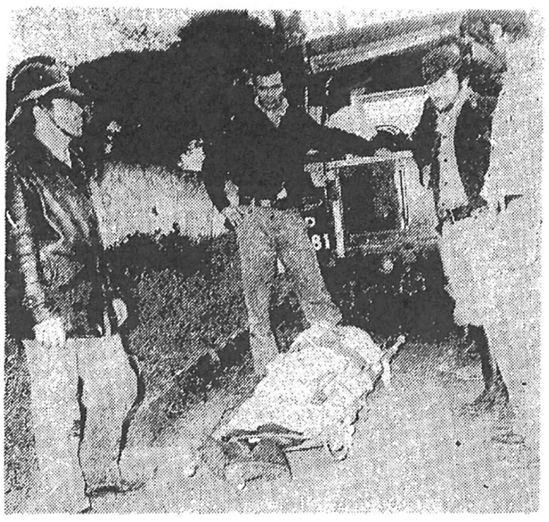
The body of unfortunate Andrew Carter; on the left and on the far right two firemen; on the near right: Martin Berkeley.
Derek Andrews came back to Madeira in June, to clean up the place as “the last observer to be stationed at the site at Encumeada Alta” 132 : the definitive end to the presence of the British astronomers in the island. 133 Today, the hut is all but gone, consumed in campfires in the 1980s. 134 The concrete base is still there, as well as the protection stone wall (Figure 9). The two seeing towers had better luck, still standing in the Encumeada Alta plateau—Figures 4 and 5. The site was recently visited by three former observers (Figure 10).
The main hut site in 2012, with the stone walls still standing. Notice the west opening on the wall for the path that led from the hut to the south tower, seen in the distance (see Figure 3).
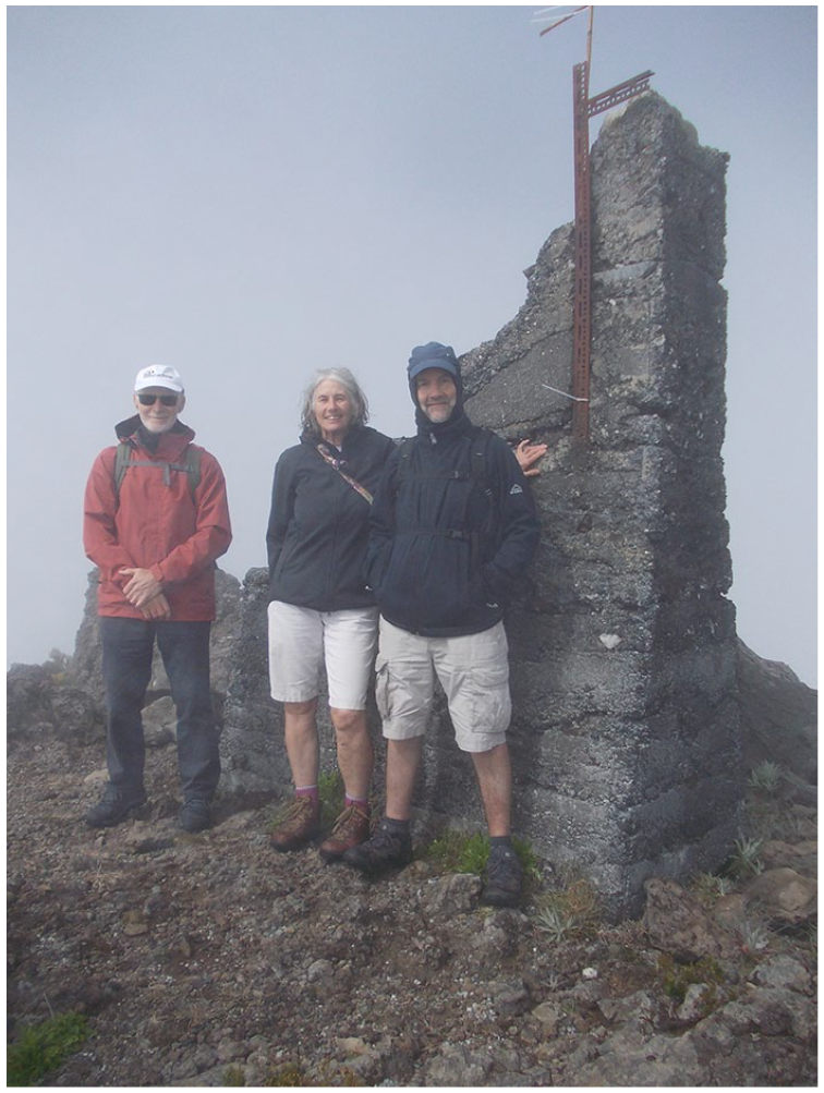
The return of three observers to Encumeada Alta, over 40 years later. From left to right, Malcolm Hartley, Laura Hartley, and Philip Henley by the south tower. Photo taken on 19th May 2018.
The NHO and Madeira—incongruent decisions and results
Maybe because of transferring the temporary “tower” from Pico Ruivo to Encumeada Alta in late August 1973, the observers also looked for the highest peak there and placed the tower on it. This so-called “south tower” (see Figures 3–5) was wrongly placed according to the northeasterly dominant winds. Merle Walker, in his consultancy report produced right after his visit to the site in 1973, wrote that 135 “to the west and south of Encumeada Alta lies a complex of peaks of nearly the same altitude as the site. Only toward the north to northeast is there a relatively smooth slope from the site down to the seacoast” (my emphasis). Further down the same report Walker wrote 136 : “the highest point of the ridge [. . .] appears to be the best choice of location for the first measures at this site [. . .] Simultaneous observations should eventually be made at different points along the Encumeada Alta ridge” (my emphasis).
Several months later, a “north tower” was finally built and all equipment moved there (Figure 3), since it was probably the best place from the point of view of the seeing quality. Still, to me, it seems that the best location there might actually be closer to the NE end of the Encumeada Alta plateau (Figure 3).
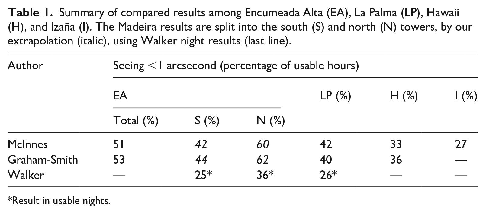
Walker published conflicting results with McInnes and, in fact, with himself. 137 Surely, by then, this was work in progress (with a different number of months in each study) but having Encumeada Alta in three ways did not help: the results from the two towers appear both separately (Walker 138 ) and together (McInnes 139 ; Graham-Smith 140 ). Although the Encumeada Alta “north tower” is far better than Fuente Nueva (La Palma) Table 1—this does not translate so obvious to Encumeada Alta taken as a whole. Worse: McInnes 141 and Graham-Smith 142 used the same data but obtained different results! (up to 11% different) In Table 2, we confront McInnes 143 and Walker 144 results for Encumeada Alta, wherein McInnes’ mixed results are evident.
Summary of compared results among Encumeada Alta (EA), La Palma (LP), Hawaii (H), and Izaña (I). The Madeira results are split into the south (S) and north (N) towers, by our extrapolation (italic), using Walker night results (last line).
Result in usable nights.
Summary of compared results for (mixed) Encumeada Alta (EA), and its north (N) and south (S) towers, where data are available.
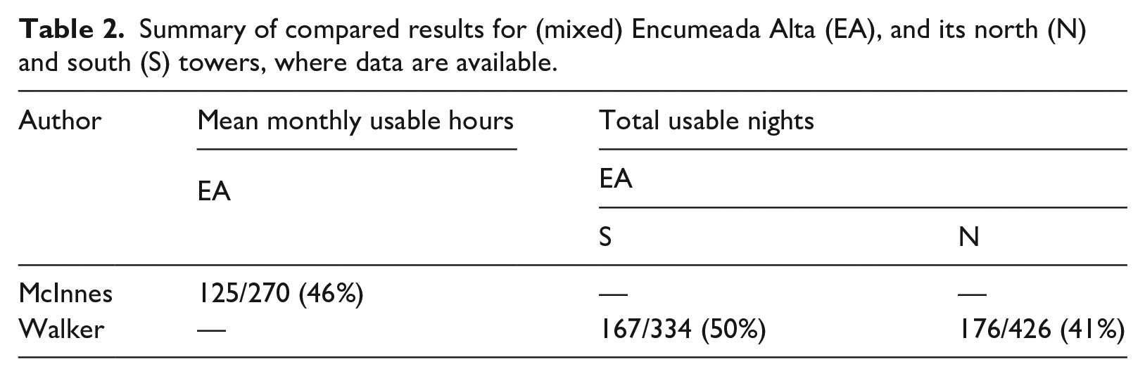
Table 2 shows that Encumeada Alta has about half of the nights in a year usable. It was McInnes himself (in March 1974) who supported Madeira in an RAS meeting saying that 145 “nearly 50% photometric nights [. . .] is anything but poor” (in January 1974, the worse tower was giving good results). In another definition 146 “a telescope at a good mountain site provides about 160 clear, dark nights per annum” (i.e. about 44% of the total nights). Hence, Encumeada Alta is, at least, good as regards usable nights and very good as regards seeing.
The NHO at La Palma (with a new name)
In November 1974 the SRC decided to support the transfer of the refurbished 2.5 m INT plus two new telescopes, 1 and 4.5 m in diameter 147 —the Isaac Newton Group (ING) since, following “international discussions which took place during [1974]”, the British could resume “site testing in the Canary Islands towards the end of the year [1974].” 148 Local leadership, however, passed on to Spain (University of La Laguna), in an international project also including Sweden, Denmark, and Norway. 149 In May 1979 the formal agreements among all parts were signed 150 for the “Roque de los Muchachos Observatory.” 151
The current period (1990s onwards): Glory and hopes
Portugal, ESO, and Madeira
Portugal signed the accession agreement with ESO in a “festive ceremony on 10 July 1990,” 152 for a formal entry that happened in 2001. In the meantime, the country-level compromise was to spend the equivalent of the ESO quota on “the development of research in the field of contemporary astronomy,” mostly for projects and “advanced training of human resources.” The 1990s were, indeed, the decade of the “astronomy revolution” in Portugal, reaching almost 100 doctors within the period. It, thus, came by as very appropriate to found the National Astronomical Society in 2000 with its most relevant “White paper for Astronomy in Portugal” 153 published in 2005, where the UMa (only established in 1988) managed a very honorable fourth place (among twelve) in what concerned to competitive project funding. In addition, it was the only other University (besides Porto) with an astronomy degree. 154
At the 1990 Portugal/ESO agreement ceremony the “very attractive” perspective of a national astronomical observatory at Madeira was mentioned, something that “should not be excluded in the long run” 155 even if it might be better to use already existing international facilities elsewhere (including ESO). In 1993, the just set up Portugal/ESO Committee “noted with great interest and enthusiasm the current plans to establish a Portuguese national observatory on the island of Madeira,” 156 also open to international participation. By then, Chile was having some issues with the ESO’s VLT installation. So, in 1994, ESO established the Working Group “ESO Search for Potential Astronomical Sites” (ESPAS) with a Portuguese representative (until 1996). ESO and Chile solved their disagreements but ESPAS carried on, for a while, in order to create a multi-site homogeneous seeing dataset. 157 Their list included Madeira and at the 18th March 1996 meeting it was mentioned the “feasibility study for the development of an astronomical observatory in Madeira” and that “a detailed proposal [. . .] was [further] submitted still in 1995 [that] included the creation of a research support Institute in Funchal,” 158 the so-called Funchal Institute of Astronomy (IAF).
The University of Bochum (1995–1996)
Since the late 1950s (before ESO) the Germans were looking for excellent sites at the southern and northern hemispheres, having studied Tenerife in 1959 but getting scared away by the Saharan dust there. After two Mediterranean sites had seeing measurements made (1966–1972) 159 the Germans 160 settled at Calar Alto (“[not] the best site in the Mediterranean area” but a good site and, eventually, they placed there their largest telescope (3.5 m), among two others (1.2 m, 2.2 m), constituting Germany’s “northern hemisphere observatory (NHO).” 161
In the 1980s, Theodor Schmidt-Kaler and Gerhard Schnur (from the University of Bochum) worked on an innovative “hexapod” mount called SVELT or SVELTE (Six Variably Extended Legs Telescope 162 ) but the 1.5 m prototype was only ready in 1999. 163 Seven years before, they were actually contacted by the Portuguese government and the two parties were working together towards placing the telescope at Madeira. The Hexapod was ultimately placed in Chile (Cerro Armazones) but only worked there for 9 years (2006–2014). After all, the site had to be substantially transformed (including the use of dynamite) to open space for the ESO Extremely Large Telescope (ELT). . .
From the 23rd to 30th November 1995, Schmidt-Kaler and a third Bochum member (Josef Gochermann) actually came to Madeira, visited three sites (Encumeada Alta, Pico Ruivo de Santana; and a new one: Pico Ruivo do Paul, 1640 m-high), quickly estimated their seeing and suggested, even with the very little data they collected, that the new one (Pico Ruivo do Paul) was likely the best. 164 They managed to recruit and train no less than 15 UMa student volunteers to perform seeing measurements at the three sites during the full year of 1996. Two exposures of 6 + 6 minutes of 10°-within-zenith stars were made with a Questar telescope in the middle of the night and 1 hour before/after the sun rose/set. 165 However, the observations only lasted from April to August 166 and the seeing data were never properly processed. 167 From the total of 106 nights of observations, there were 57% of clear nights at Pico Ruivo de Santana, 50% at Encumeada Alta and only 39% at Pico Ruivo do Paul 168 (not so good, after all). On the 17th of December the Portuguese Science Minister put an end to it all saying that building an observatory at Madeira was, then, not possible, not because of the quality of the site (which was likely excellent) but because of the lack of interest of the international community, which was approached by him beforehand. 169
The formal Astronomy Group of the UMa (2000–2010)
In 1997 the author became the first doctorate in astronomy at UMa. For a couple of years successful research projects assured, not only, science funding but also the most necessary equipment and bibliography: 80% of the volumes in the 2002-founded Library of Astronomy and Astrophysics came from donations! Today, it is one of the best in the country.
The Astronomy Group of the University of Madeira (GAUMa) took formal shape within the Mathematics Department in June 2000. Its first major task was the organization of the 11th National Astronomical Meeting which took place, for the first time, in Madeira, on the 26th and 27th July 2001. 170 The 1st Astronomy Week also took place simultaneously, opening up a yearly public event that lasted until COVID-19. 171
Besides research and public awareness of science (e.g. the spectacular International Year of Astronomy 2009 (IYA09) at Madeira 172 ), teaching became also an immediate priority of GAUMa and a 5-year engineering degree (Licenciatura in Instrumentation and Electronic Engineering—Astronomy branch) opened up in 2001/02, bringing together the cooperation of no less than six departments of UMa. 173 Plagued by low student numbers, the course was shut down in 2009/10 but three “astronomer engineers” did graduate.
Yet another attempt for an optical observatory at Madeira and new seeing measurements
After a few internal (UMa) and external (FCT—Portuguese National Science Foundation) successful project applications, there was support to purchase a full fiberglass observatory-dome structure (in 2000) as well as a 30 cm telescope, a CCD detector, a spectrometer and auxiliary equipment. In July 2001, it was the President of the Madeira Regional Government himself, publicly, in the opening ceremony of the 11th National Astronomical Meeting, to give “green light” to the installation of the UMa observatory at Encumeada Alta, after 1 year pending in his Office. In his words “the Region is not rich [and] must find new development strategies [. . .] New paths should be followed [. . .] betting on quality, intelligence, innovation [and] scientific knowledge.” 174
Practicalities, however, “sent” the observatory site down, to Achada do Teixeira (1590 m-high), about 1 km east of Encumeada Alta (which was, then and now, a Nature 2000 preserve). The municipality of Santana paid a fence and concrete pad which were only installed in May 2004. 175 The observatory was, finally, put in place in October 2004 (Figure 11a). Not to last long, though, since only 5 days later a storm sent the dome down the mountain 176 (Figure 11b). Luckily, the structure was empty inside. And an insurance had been made, which meant that the full structure was recovered at no extra cost to UMa. . . except time! In fact, the new observatory set only arrived in July 2006. The plans were, then, to make it robotic, controlled from Funchal, since the local installations at Achada do Teixeira were not available for astronomy (they are a restaurant/inn today). Until this day, no matter what efforts are and have been made, the structure is still in storage!
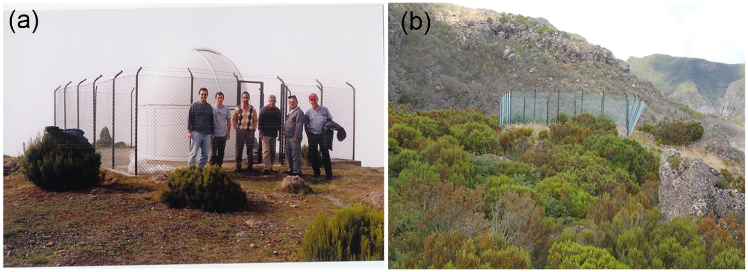
(a) The observatory mounted in October 2004 and ready to be equipped to start observing at Achada do Teixeira. (b) Just 5 days later a storm (160 km/h) sent the dome downhill, bending the fence as it went, which is clearly seen in the photo.
The manpower context was ideal in 2006 since the first students were reaching the final year of their 5-year “licenciatura” degree and one of them (Ilídio Andrade) actually picked the challenging project of repeating the McInnes seeing measurement efforts at Madeira, with three relevant differences: (i) eight sites would be studied: Achada Grande (1580 m), Juncal (1796 m), Loiral (1403 m), Pico Ruivo do Paul (1640 m), Bica da Cana (1620 m), Achada do Teixeira (1590 m), Pico Ruivo de Santana (1862 m), and Encumeada Alta (1784 m); (ii) weekly visits would be made to the first two sites, every 2 weeks for the following four and every month for the last two; (iii) the circulation was made by motor vehicle and then on foot, at each site, sometimes for over 1 hour; 50 kg on 80 items of equipment were carried on two large rucksacks, one of which also carrying the “star” of the project, a patented, 177 portable, sturdy, stable, inclination-adjustable mount for placing an 11 cm Newtonian. 178
The study took place from 1st February 2008 until 5th March 2009 (58 weeks, over 13 months). Preparation took slightly longer, from November 2006 to January 2008. Initially, the plan was to cover all eight sites in a single night but this was, in fact, impossible. The maximum number of sites possible to do (from sunset to sunrise) in a single night was five. The Walker method was used: five-minute CCD exposures of the Polaris tracks. 179 Full details of the setup and results will be published soon. Also noteworthy is the quick light pollution scan that was made in Madeira. 180
The latest effort towards the observatory was made in late 2016 when a PhD student (Rodolfo Sousa) enrolled at UMa to work on a thesis in Astronomy Instrumentation titled “Low Cost Automated Astronomical Observatory for Remote Operation: a Requisite Analysis.” Things were going pretty well, a conference paper was published in April 2017 181 but that all changed later in 2017 when UMa decided to offer its 30 cm telescope away! Bluff or not (this actually did not happen) this was enough to scar away both the student and his supervisors from the thesis which was, then, terminated (and the student went on to do another project). It must be said that the conference paper already got over 2400 reads on ResearchGate until this day (November 2023 182 )!
The formal GAUMa activity ended after a restructuring of the UMa administrative organization. Its full story is presented in a book (in Portuguese 183 ).
The first attempt for a radio telescope at Madeira
The ideal site for a radio telescope is a shallow valley protected from man-made interference. Ideally, the site should not be exposed to frequently gusty or very strong winds. Having a radio telescope at the island of Madeira is a great chance for improving the quality of both the European VLBI Network (EVN), that now extends to Arecibo (even if there is no working antenna there at the moment), and the Very Long Baseline Interferometer (VLBI) itself, by reducing the infamous “mid-Atlantic gap.” 184
Madeira had a formal study for viability for radio astronomy that was conducted for 11 years (1999–2010). It kick-started by an initial site selection that picked three sites in the island: a week-long visit in May 1999 by a committee of experts (Roy Booth, Onsala; Richard Davis, Jodrell Bank Observatory (JBO); Gavril Grueff, Bologna) made this selection. From 2003 to 2010 continuous weather monitoring was done by one automatic weather station that stayed, consecutively, just over 1 year at each of the first two sites (called F/G and A, respectively) and 4.5 years at the last and most promising site D. 185 The details of each site are presented in Table 3.
Details of the three candidate sites for a radio telescope at Madeira.
In September 2005, 80–2000 MHz radio frequency interference (RFI) was measured for a random week, during consecutive weekdays, at the three sites by Don Lawson (JBO). Satellite data was accessed on precipitable water vapor (PWV). As main conclusions: (i) no site registered wind gusts stronger than 36 km/h; all three sites are quite humid (about 90% relative air humidity most of the year) and wet (it rains about 2.0–2.5 m per year) but with clear skies most of the time; the three can also get very dry at times (below 10% of relative air humidity); (ii) sites D and F/G have no meaningful RFI (below −90 dBm); (iii) PWV (preliminary satellite data from MODIS, 2003) on 4–13 mm over the full year, with an average of 9 ± 3 mm. 186 The two best sites (D and F/G) lie in the Porto Moniz municipality (Table 3).
Madeira was already used for radio astronomy, in fact, and the effort deserved a published report 187 : in November 1999 there was a Leonid meteor storm and UMa announced a public event at site A for optically observing the storm, as is most common. However, weather predictions were not favorable and, so, a back-up plan was put into place: car radio antennas would be used instead! And a strong radio detection was, indeed, independently confirmed by the counts made in several separate cars by a total of about 15 observers, mostly from the public, with no more than minimum guidance as training.
Summary
Six-hundred years ago, Madeira was first on a long list of Portuguese explorations and discoveries, all made thanks to astronomical knowledge and instruments. It was in Madeira that pilots learnt new techniques and perfected high seas sailing. No wonder Portugal got an Astronomer Royal almost two centuries before the first one in Britain. 188
French Jesuit Antoine-François Laval inaugurated the Astronomical Observatory of Funchal (the first one in Portugal) by using the Jesuit college tower in April 1720. In 1753, Gabriel De Bory led an expedition from France to Madeira that measured the longitude and latitude of Funchal but, soon, observers would prefer to settle in the island and use proper facilities: Nathaniel Everett Green (1877), at a “quinta” in Camacha, observed Mars from Madeira and produced spectacular drawings; Charles Piazzi Smyth (1881), at a hotel in Quinta do Carvalho (Funchal), took spectra of the Sun and found that “there was no haze that was not resolvable into the most exquisitively sharp and well defined lines,” his most relevant result being the identification of a new line of helium.
Here we have recounted how Madeira became considered a potential site for optical astronomy since it lies on the east side of a large oceanic anticyclone, on top of cold sea currents, where the stable tropical maritime air has a laminar flow (Section “The NHO and Madeira” and Appendix). The island has sites where the up-wind edge of a mountain top presents a convex orography towards the dominant wind (the ideal situation).
Merle Walker implemented the Polaris star trailing seeing measuring method with a Polaris trail telescope (PTT) in California (1965): a single Polaris photographic unguided exposure 8–10 minutes long is made through a 10–15 cm telescope. In 1969, the British Science and Research Council (SRC) established a review committee to pick the best site for the British NHO. The first three sites proposed were in Italy, southeast mainland Spain (Calar Alto) and Izaña (Tenerife, Canary Islands). Merle Walker was invited as consultant and three PTTs were made at the ROE. The first two sites were ruled out and a new one (La Palma), also in the Canaries, became interesting; but, for political reasons, the British were not allowed access from the end of 1972. So, in 1973 the British considered and studied alternatives such as Madeira and Hawaii (Mauna Kea). From the end of 1973, continuous monitoring started at Madeira where a “permanent” hut, prototype of the one later built at La Palma, was built at Encumeada Alta (1784 m), the favorite site. This lasted until May 1975 (put to an end by a tragic death). At the end of the day, La Palma (Fuente Nueva) was the British choice.
Unfortunately, the worst place in Encumeada Alta was picked to start the measurements (“south tower,” not on the edge of the slope facing the dominant winds). Only in May 1974 was there a “north tower” operational at a better site (still not the best, in my opinion—this would be further northeast). Until November the two towers had simultaneous observations (with two PTTs) and from then on and until the end (April 1975) only the “north tower” was used. Unfortunately, the results were combined (or not) in the relevant publications and the results for Encumeada Alta became ambiguous. Our 2008–2009 seeing campaign should clarify the matter (in a publication to come out soon).
The University of Bochum was contacted in 1992 by the Portuguese Government and became interested on making real the observatory at Madeira using their 1.5 m prototype of an “hexapod” telescope. In November 1995 they visited the island, gathered 15 student volunteers and from April to August 1996 these actually measured the seeing at three sites in Madeira: from the total of 106 nights of observations, there were 57% of clear nights at Pico Ruivo de Santana, 50% at Encumeada Alta and only 39% at Pico Ruivo do Paul (new site). The seeing data were never properly processed. And the observatory idea died (once more) when the Portuguese Science Minister put an end to it, in December 1996, due to lack of interest from the international community despite the likely excellent astronomical site.
Just a year after, the author was hired, becoming the first doctorate in astronomy at UMa. For a couple of years successful research projects assured, not only, science funding but also the most necessary equipment and bibliography. One astronomy Licenciatura student got involved in yet another season of seeing measurements at Madeira, in 2008/09, this time studying eight sites. A portable, sturdy, stable, inclination-adjustable mount was invented for placing an 11 cm Newtonian telescope (in a cushioned bed). The technique was a “PTT-modified” method: 5-minute CCD exposures to produce Polaris tracks.
For any interested readers, this historical review has a considerable extension published in a book 189 (in Portuguese).