
Abstract
It is believed that Vasco da Gama carried nautical tables on his first voyage to the Indies, 1497–1499, that had especially been produced for the years 1497–1500 by Abraham Zacut, then Royal Astronomer in the service of the Portuguese court. Maritime history writers have suggested two manuscripts as surviving copies of these da Gama tables. One of them is a set of declination tables in the 1519 edition of Suma de Geographia by Martín Fernández de Enciso. Analysis of all available data shows that these tables are indeed good candidates, though their production from the 1505–1508 astronomical tables of Regiomontanus and of Stöffler and Pflaum would be about equally likely. The other candidate is a set of solar ecliptic longitudes, found in the Livro de Marinharia, attributed to André Pires. It is shown that with certainty these have been taken from 1505 to 1508 of Regiomontanus/Stöffler-Pflaum and therefore cannot have served da Gama on his first voyage.
Keywords
Introduction
On 8 July 1497, Vasco da Gama’s fleet of four ships set sail from Restello, just south of Lisbon, for his first voyage to the Indies. He returned to Lisbon on 29 August 1499.
During the preparations, he had consulted the Royal Astronomer, Abraham Zacut, on matters of celestial navigation. Zacut’s ephemerides, among them solar tables for 4 years, 1473–1476, had been translated from Hebrew into Latin by his assistant José Vizinho and had been published in 1496 under the title Almanach perpetuus celestius motuus, 1 almanac of the perpetual motions of the heavens. For the sun, it showed how to find the solar ecliptic longitude for later years by adding to them 1ʹ 46ʹʹ for each elapsed period of 4 years. In astronomy, the customary notation for ecliptic longitude is λ. This article deals, however, also with nautical astronomy, where parameters are usually abbreviated as three-letter acronyms. As in an earlier article on nautical tables, 2 I will henceforth denote ecliptic longitude as ECL. Conversion to declination (DEC) is done via the simple formula

where ε is the obliquity angle between the plane of the ecliptic and that of the equator. At the same time, this obliquity constitutes the maximum value of the declination which it reaches in the solstices. Zacut’s Almanach gave a table for this ECL to DEC conversion for an obliquity of 23° 33ʹ.
It is the declination that a mariner will need to find his latitude from a measured height of the sun at local noon. Hence, it would save the navigator time and effort if he had the solar tables ready for the current year, in Vasco da Gama’s case, for 1497–1500. That would be Zacut’s tables shifted over six times 1ʹ 46ʹʹ. Even better would it be if also the second step, the conversion to declination, would have been done in advance for the same quadruplet of years.
It is believed that such tables might have existed, prepared especially for da Gama’s first voyage. One such possibility is the Livro de Marinharia of André Pires,3,4 a manuscript discovered in the National Library in Paris in the early nineteenth century. It has two groups of 4-year tables, both for declinations and for ECLs. The declinations are the same in both groups, and they are identical to those found in another Livro de Marinharia, that of João de Lisboa, 5 and to those in a printed book, known as the Regiment of Évora, 6 so named after the city where the only known surviving copy was found. These declination tables may be identified as made for the years 1517–1520. They have also been reproduced in Os guias náuticos by Luis Mendonça de Albuquerque. 7
While the declination tables of Pires are the same in both 4-year groups that he presents, the tables for ECLs are not. Most of the second group is written for 1517–1520, as are the declination tables, but the ECLs in the first group of 4 years look significantly older and most of them seem to apply to 1497–1500. This is also the conclusion of de Albuquerque in his book O Livro de Marinharia de André Pires. 4
The possibility that also declination tables would exist or have existed for 1497–1500 had earlier been suggested by Luciano Pereira da Silva, 8 who analysed the declination tables in Suma de Geographia (1519) of Martín Fernández de Enciso, 9 a Spanish geographer and explorer, and had suggested that these tables might have been prepared for Vasco da Gama’s first voyage to the Indies of 1497–1499.
In the dating of both sets of tables, the ECLs of Pires’ groups 1 and the declinations of de Enciso, the tacit assumption had been made that the underlying ECLs are extrapolations from the solar tables in Zacut’s Almanach. There is, however, another possibility: Hans Müller from Königsberg, Bayern, writers name Johannes de Monte Regio and today better known as Regiomontanus, had produced daily ephemerides 10 for each year from 1474 to 1506. These were readily available, reprinted 11 even as recently as in 1492. This series had been continued in the same style and format by Johannes Stöffler and Jacob Pflaum. 12 Zacut’s chosen meridian was that of Salamanca, 11 minutes in solar time to the west from Toledo, which was the standard meridian for the Alfonsine tables.13,14 Regiomontanus had taken Nuremberg as his meridian, 84 minutes east from Toledo by his own estimate and by that of the Alfonsine tables. Stöffler and Pflaum had chosen Ulm, nearly coinciding with Nuremberg in solar time. The difference in ECL for the sun passing the meridians of Salamanca and 95 minutes earlier that of Nuremberg is on average 3ʹ 54ʹʹ, which is pretty close to the equation of the sun 15 of two times (1ʹ 46ʹʹ) = 3ʹ 32ʹʹ, the equivalent of an 8 years’ time lapse. Hence, we must investigate the alternative that the tables, instead of for 1497–1500, could have been made for the years 1505–1508, in which case they would have been based on Regiomontanus (1505, 1506) and on Stöffler-Pflaum (1507, 1508).
The ECLs from André Pires’ group 1
Tables, such as these, had likely been copied and recopied a number of times, and in the process, errors had crept in, especially in the columns that list the degrees of the ECLs, which the copyist would have filled out almost on the automatic pilot as increasing by one degree per day. The columns for the arcminutes would require much more concentration and indeed mistakes are fewer there.
Figure 1(a) shows Pires’ ECLs, plotted on a scale where the base lines for the first through fourth year have been taken from Alfonsine tables calculations for 1497–1500 at the meridian of Salamanca. These calculations have been made following the scheme as it is given in the Alfonsine tables of 1483 and 1492. On the scale of the figure, the difference with a calculation for the meridians of Nuremberg or that of Ulm for the years 1505–1508 is negligible.
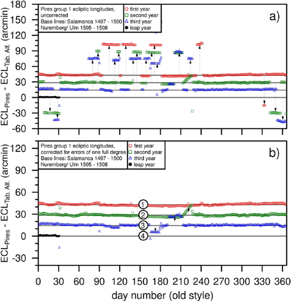
(a) Pires’ ECLs for his years 1–4 of his group 1, uncorrected. Arrows indicate apparent misplacements of 1° precisely and (b) the same ECLs corrected for 1° misplacements. Note that for the fourth year only data for January are available, as for the rest of the year, only the full degrees are given, not the minutes. The remaining discrepancies in the second and third year are indicated by arrows and discussed in the text.
I have re-analysed these tables, re-adjusting the degrees, which may be off by one or two units either to the plus or the minus. The minutes I left untouched, with the exception of a few very obvious mistakes. The so cleared data are displayed in Figure 1(b). Obvious discrepancies, other than a full degree shift, are still found in the second and third year. They are, from left to right in the figure, as follows:
From 14 June, third year, till the end of the month, the minutes parts have been shifted by 3 days. As around midsummer, the daily step size of the ECLs is 3ʹ short of one degree, this amounts to a misplacement of around 9ʹ. This mistake has also been identified by de Albuquerque. 3 Though misplaced, one recognizes numerical values of the minutes parts, as given by Stöffler and Pflaum 1507.
From 12 July, third year, till the end of the month, the ECLs have been read from the second year. From 22 July till the end of the month, the minutes parts are displaced by 1 day. One recognizes the numerical values from Regiomontanus’ tables for 1506.
From the beginning of August, second year, till the 14th, the daily pace of the ECLs is typically 1ʹ too fast, accumulating to a misplacement of 15ʹ on 14 August, whereafter the error is reset and the daily pace is normal again.
Figure 2 shows the analysis of the cleared-up ECLs for the first 3 years of group 1. The fourth year is incomplete, because the minutes are listed only for January, while the remainder of the year gives just full degrees. In the upper panels, Figure 2(a) to (c) displays the fits that result from a comparison with Zacut’s tables, shifted over 10ʹ 36ʹʹ, the equation of the sun needed to make them apply to the quadruplet of years 1497–1500. This is, however, not how the tables were made. I find that instead they were, to a large extent, copied literally from the tables of Johannes Stöffler and Jacob Pflaum for the years 1505–1508. For 1505 and 1506, these are copies of the last 2 years of Regiomontanus’ tables. The further tables, 1507–1531, have been made for the meridian of Ulm, which Stöffler and Pflaum quote as 82 minutes east of Toledo. I find this to be true for almost all of their later tables but, remarkably enough, not for the years that we investigate here, 1507 and 1508. For these years, the tables definitely require a solar time difference of only 60 minutes. Accidental or not, this would make them correspond to Tübingen, where Stöffler was professor in astronomy.
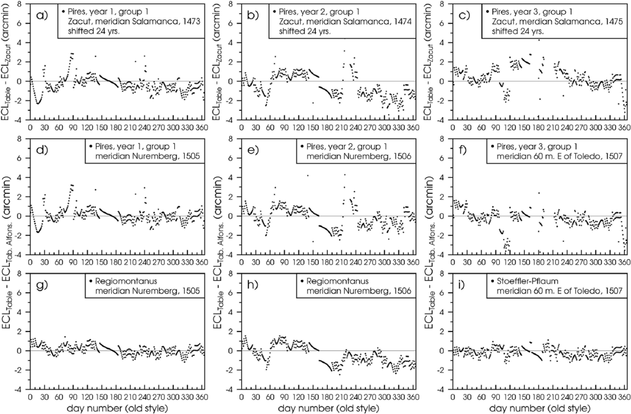
Ecliptic longitudes of the years 1–3 from group 1 of Pires’ Livro de Marinharia, cleared of evident misplacements of 1 full degree. (a, b, c) Compared with 24-year shifted solar places of Zacut. (d, e, f) Compared with the Alfonsine tables for 1505, 1506 at the meridian of Nuremberg, and for 1507 at a meridian 60 minutes E of Toledo. (g, h, i) The solar tables of Regiomontanus and Stöffler-Pflaum for 1505–1507.
A word on the choice of the meridian is in order. The above case is an example of a practitioner, who, for a given city, uses a longitude that differs from the one adopted by the Tabula Regionum of the Alfonsine tables. Kremer and Dobrzycki 16 have found many such cases from around 1500.
What then about the tables of Zacut and those of Regiomontanus? Zacut places Salamanca at 11 minutes to the west from Toledo. Recent computations by Chabás and Goldstein 17 and by van der Werf 2 confirm that he did so consistently.
For Regiomontanus, the situation is more complex: he published no less than 34 tables of annual solar longitudes, for 1472 in his Kalendarium 18 and for 1474–1506 in his Ephemerides.10,11 A check on 6 full years, 1472, 1475, 1476, 1504, 1505, and 1506 to find a “best fit” gives a scatter of values, of which indeed 84 minutes east from Toledo is a good average. A sometimes encountered feature is that the best meridian value for the first half year differs from that for the second half. The year 1506, discussed below, is such an example.
In the following, the ECLs of Regiomontanus and those encountered in Pires’ manuscript will be compared both directly and by individually plotting them against a common computation for a meridian 84 east from Toledo, which then will be called the “meridian of Nuremberg.”
Fits of Pires’ tables with Alfonsine tables based calculations are shown in the middle panels, Figure 2(d) to (f), and the corresponding fits for the ECLs of Regiomontanus and Stöffler-Pflaum are given in the lower panels, Figure 2(g) to (i). One even recognizes details such as the (erroneous) global break of 1ʹ across the solstice in Regiomontanus ephemerides of 1506, which is also seen in Pires’ table.
These fits are much better than those by shifted Zacut tables. A shortcoming of the latter method is that it shifts the equinox but not the apogee, which really should have been chosen about 15ʹ larger. To make things worse, Zacut’s tables for 1474 and the first half of 1475 are not independent calculations, but shifted versions of his year 1473. The effect of this omission is that the apparent places of the apogee are already too small by 15ʹ and 30ʹ, respectively, as I have shown in an earlier paper. 2 The combined effect of these errors shows up as a depression of the fit near the beginning and the end of the year, while the middle part is raised.
Another way to distinguish between Regiomontanus/Stöffler-Pflaum and Zacut is to simply count in these tables the number of days for which the minutes part of the Pires’ ECLs is found identically the same. For Regiomontanus and Stöffler-Pflaum, this is a direct comparison. For Zacut’s tables, which are given to a precision of arcseconds, one has to first apply the shift of 24 years and then round off to the nearest full minute of arc. In doing so, I find for Pires’ first year agreement with 1505 of Regiomontanus on 302 days and for Zacut’s tables shifted to 1497 only 171. For the second year, 1506 of Regiomontanus and 1498 for Zacut, these numbers are 274 v. 65. For the third year, 1507 of Stöffler-Pflaum gives agreement for 224 days v. 130 for Zacut’s 1499. Finally, for January of the fourth year, the agreement exists on 27 days for Stöffler-Pflaum’s 1508 v. 22 for Zacut’s 1500.
There can be no doubt: Pires’ tables of his group 1 have been copied from Regiomontanus and from Stöffler and Pflaum, and they apply to the years 1505–1508. If Vasco da Gama would have had ECL tables with him for 1497–1500, those must have been different ones.
The declination tables of de Enciso’s Suma de Geographia (1519)
As mentioned above, the declination tables of de Enciso have also been suggested as possibly written for 1497–1500 and have been linked to the first voyage to India of Vasco da Gama.
Figure 3(a) shows the ECLs as they follow from his tabulated declinations by inverting equation 1. This procedure is accurate in a wide range around the equinoxes where the declinations change rapidly. It loses precision near the solstices, where the daily change of the declination is slow. Therefore, the regions in the immediate vicinity of the solstices have been left out from the analysis.
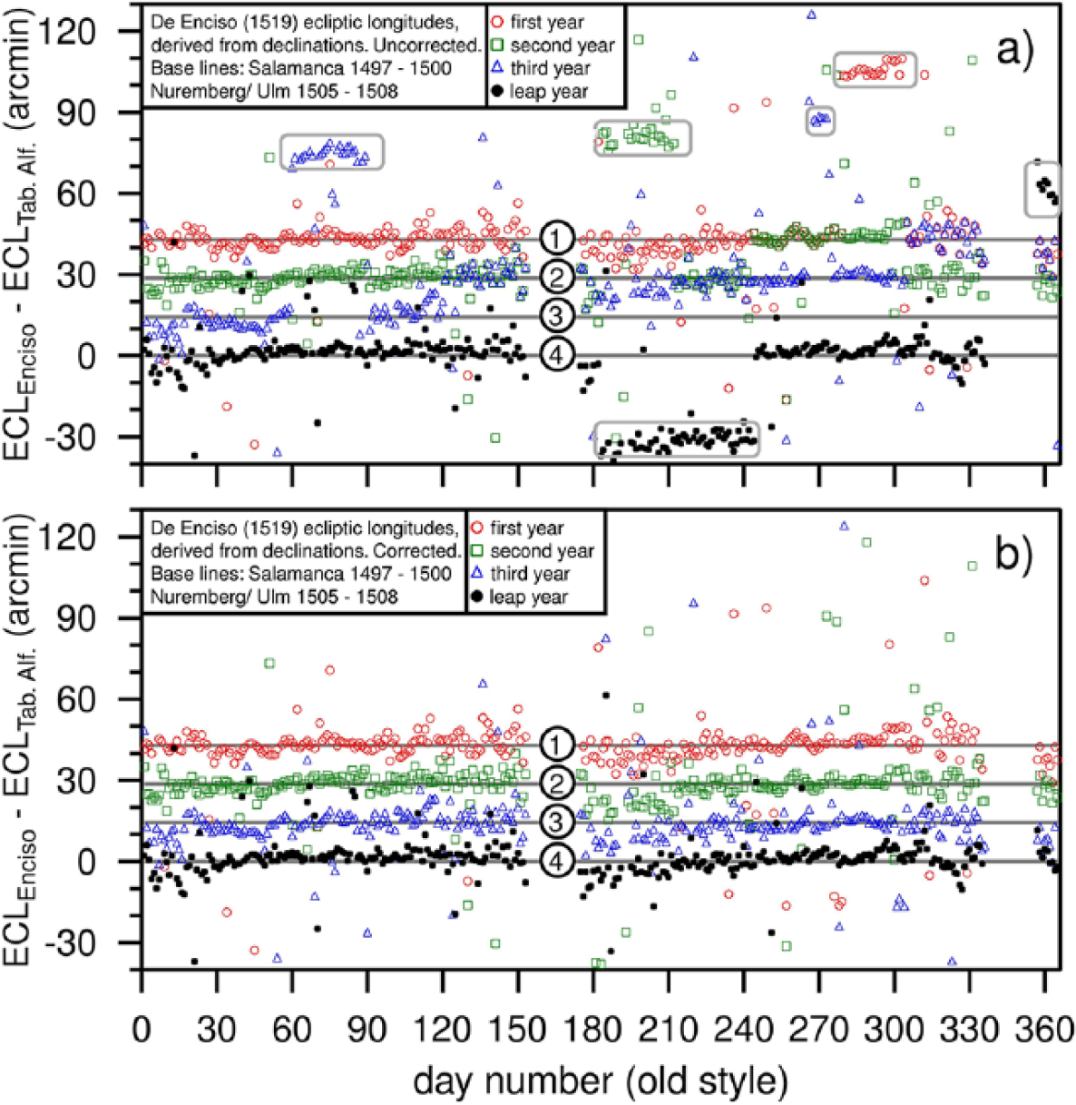
Ecliptic longitudes derived from the declinations in de Enciso’s Suma de Geographia (1519). (a) Uncorrected. Systematic misplacements explained in the text are indicated by boxes and (b) cleared of apparent misplacements. Both (a) and (b) are compared with calculations via the Alfonsine tables.
Next, these so derived ECLs have been corrected for the following apparent errors:
Year 1: October, a 1° shift.
Year 2: A 1° shift for March. September and October have been read from the first year.
Year 3: 1° shifts for March and for the last week of September. May through October have been read from the second year. November and December have been read from the first year.
Year 4: July and August have been read from the second year, under the same calendar date. ECLs for December have a 1° shift.
The accordingly corrected ECLs are shown in Figure 3(b). As an aside, note that the misplacements are different from the ones that we found in the ECLs of Pires’ group 1.
Declinations are sensitive to the position of the equinox, and this enables us to date the tables as having been made for 1497–1500, assuming that they have been based on Zacut’s solar places, shifted over 24 years. The equally good alternative would be to assume that they have been made from the tables of Regiomontanus and Stöffler-Pflaum, in which case they are for 1505–1508.
Figure 4 shows the uncorrected declinations along with the ones that have been cleared of the above misplacements. Unlike in a direct comparison of the ECLs, which as we saw above, can distinguish between the two scenarios on the basis of the incorrect and erroneous placement of the apogee in Zacut’s tables, declinations are rather insensitive to a misplacement of the apogee as long as it is close to the solstice.
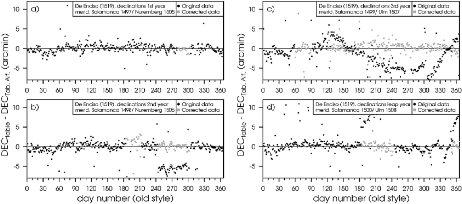
The declinations as published in de Enciso’s Suma de Geographia of 1519 are in black. The declinations after applying the corrections for misplacements as explained in the text are in grey.
Indeed, the rms (root mean square) deviations upon fitting the corrected data with either Zacut or Regiomontanus/Stöffler-Pflaum differ little. Typically, these rms values are around 0.8ʹ, and their differences are not statistically significant.
There is an argument that points to the use of Zacut’s tables at least for converting ECLs to declinations. In the first place, the maximum declination in de Enciso’s tables is 23° 33ʹ, which is the value in Zacut’s Tabula declinationis. Regiomontanus used lower values for the obliquity. He and his teacher Georg Peuerbach had themselves measured a value of 23° 28ʹ, as published in their Epitome in honour of Ptolemy. 19 A published conversion table for 23° 30ʹ was available in Regiomontanus’ Tabulae directionum. 20 For other values of the obliquity that Regiomontanus has considered and also for a survey of printed editions of the Epitome, see the great book of Ernst Zimmer on Regiomontanus’ life and work.21,22
Figure 5 shows the differences of Zacut’s tabulated declinations and the exact calculation, made as in equation 1. Rounding off to the nearest integer arcminute gives a band of −0.5ʹ to +0.5ʹ, within which all differences should be confined. This rounding off has not been done correctly in quite a few cases: 15 points out of 90. It is found, however, that for all four de Enciso tables, the rms deviations are systematically about 10% larger when fitting with the exact formula of equation 1 than upon fitting with Zacut’s conversion table. This makes the use of the latter very plausible. This observation does not, however, exclude the tables of Regiomontanus/Stöffler-Pflaum as a possible source of the underlying ECLs, since also for them the improvement in rms deviation upon using Zacut’s conversion table holds just the same.
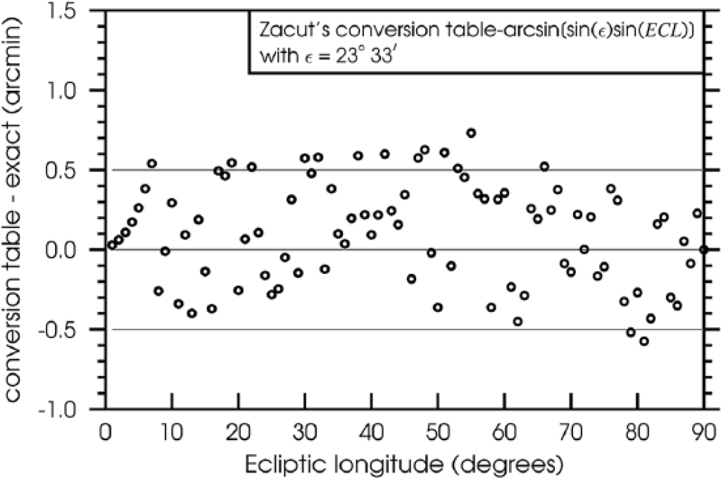
Differences in declination between Zacut’s conversion table and the exact formula of equation 1.
Discussion and conclusions
In preparing for his first voyage to the Indies, Vasco da Gama could still benefit from contacts with Abraham Zacut, a Jewish rabbi and astronomer, who held the position of Royal Astronomer at the Portuguese court, first under King João II and later under King Manuel I.
Da Gama set off in early July 1497. Later that same year, Zacut left Portugal to escape enforced conversion to Christianity that was imposed as of October 1497.
It is believed that Zacut had provided da Gama with nautical tables, prepared for the years 1497–1500. In this article, two sets of tables are investigated that have been suggested as possible surviving copies. One of them is a 4-year tabulation of solar ECLs, found in a manuscript that is attributed to André Pires, which is known as his Livro de Marinharia.
While in the past such analyses would almost necessarily have to be restricted to partial comparison only, today, with sufficient computing power available, even for a retired researcher, and digitized astronomical tables freely accessible, a full analysis is possible (and desirable) of all the available numerical data. In doing so, I find that Pires’ tables have not been based on extrapolations of the Zacut tables for 1473–1476, made for the meridian of Salamanca, as has been suggested. Instead, they have been copied from the later tables of Regiomontanus and those of Stöffler and Pflaum, for the years 1505–1508. These had been made for the meridians of Nuremberg and Ulm, respectively. Their distance in local solar time from Salamanca was, according to the Alfonsine tables, almost precisely the difference that ECLs would acquire during 8 years, the “equation of the sun.”
The conclusion that the Pires’ tables are based on Regiomontanus/Stöffler-Pflaum and not on Zacut relies on their much better agreement when compared with direct Alfonsine Table calculations in both scenarios. It also follows from simply counting the number of days in a full year, for which the minutes parts of the tabulated ECLs are identical.
The other candidate for Vasco da Gama’s tables is the 4-year tabulation of declinations in Suma de Geographia, edition 1519, by Martín Fernández de Enciso. The two scenarios to be considered are again the same: Zacut’s tables extrapolated to 1497–1500, v. Regiomontanus/Stöffler-Pflaum 1505–1508. Declinations are much less affected by a wrong placement of the apogee, and statistical analysis suggests equal likelihood for both options. However, there exists an argument why the Zacut option might be slightly preferred: de Enciso’s maximum declination is 23° 33ʹ, as adhered to by Zacut, and the conversion of ECL to declination has almost certainly been done via the conversion table that Zacut provides for it in his Almanach perpetuus celestius motuus.
There should of course be no doubt that da Gama had astronomical tables with him that would cover the years of his voyage, but our analysis shows that Pires’ tables from his group 1 is not a surviving copy of them. If we assume that he even had pre-computed declination tables especially made for the years 1497–1500, then the tabulation in the 1519 edition of de Enciso’s Suma de Geographia is a good candidate.
I conclude with a note on the history writing of the time of the great discoveries. Around the beginning of the twentieth century, Zacut seems to have been quasi forgotten in Northern Europe, maybe in part because his name is missing on the revised version of his Almanach, 23 printed in Venice, 1502. In his impressive work Kritische Untersuchungen (1836) on the discovery of the New World, Alexander von Humboldt 24 deals at length with the voyages of Columbus and Vespucci. He assumes that both made use of Regiomontanus’ Ephemerides. This point of view was shared by later German historians, some of whom gave it as their opinion that Portugal had relied heavily on foreign knowledge, especially German astronomers and notably Regiomontanus and his former student Martin Behaim, who was a member of the Junta dos Mathematicos, the board that advised King João II on nautical matters.
Things changed after Ernst Ravenstein, 25 a German living and working in England, “rediscovered” Zacuto in 1908. Two manuscripts of Portuguese provenance were found, one in the Royal Library of Munich 26 and the other in the library of Évora. 6 They feature nautical tables, a short introduction in cosmology and the “regiment of the North Star.” Credits for recognizing their importance and for documenting them are due to the Portuguese Joaquim Bensaúde.26,27
In a quest to reclaim for his country what he sees as the intellectual priority behind the great discoveries, Bensaúde then attempts to argue away virtually all German influence on Portuguese astronomical knowledge, in particular of Behaim and Regiomontanus.27,28
The reader who wants to re-live this curious episode of polemics should also read Herrmann Wagner’s 29 thoughtful response and conclusion of 1918.
This same attitude as Bensaúde’s one finds with Luciano Pereira da Silva, 8 Luis Mendonça de Albuquerque4,7 and other sources quoted in these latter references. The only possibility considered is that nautical tables must have been derived by extrapolation from Zacut’s tables. The simple result of this article, that the ECL tables for Pires’ group 1 have been copied from Regiomontanus/Stöffler-Pflaum, could and should have been recognized much earlier. In the same way, the fact that Pedro Nunez 30 did not derive his solar tables from Zacut, but simply copied them from Philipp Imsser, 31 successor in the line of Regiomontanus and Stöffler, has not been recognized. 2
The successes of the Portuguese and Spanish discovery voyages were not achieved by ignoring foreign expertise and knowledge, but by making good use of it.