
Abstract
This article posits a simple, yet provocative, argument: post-disaster relocation sites are camps characterized by “incompleteness” where multiple actors seek to govern. The discursive framing of relocation sites as long-term solutions where residents are safe from natural hazards and integrate into their new communities suggests that relocation sites are not camps. Within these camp spaces, diverse actors attempt sometimes competing, sometimes complementary, forms of governance. Conceptualizing post-disaster relocation sites as camps allows us to scrutinize the governing practices that shape socio-spatial relations and subjectivities of disaster-affected people long after a “solution” to their initial displacement has supposedly been attained. By privileging the notion of “incompleteness” over “finishedness,” we better understand the tangible and invisible forces that inflect disaster recovery efforts, on one hand, and the regulations, negotiations, and resistances that transpire within these post-disaster spaces, on the other. Drawing on empirical studies of relocation sites in the Philippines and Japan, we examine camp governance. We deploy three conceptual filters—politics of loss, spatial forms and practices, and resistance—to study the assemblages of rules that shape life in resettlement sites, the unrecognized modes of meaning-making, the affects entangled in socio-spatial practices and encounters with material forms, and the resistances to prescribed “ways to live.” Such analyses explain why relocation sites are camps, and what are the implications of obscuring this conceptualization.
Introduction
In the context of natural hazards-related disasters, relocation is typically deployed as a planning tool to achieve broader goals of post-disaster recovery and reconstruction, and/or risk reduction, development, adaptation, and resilience (Balachandran et al., 2022). It transpires at multiple scales, with the relocation of individual households, multiple households, or entire communities (Balachandran et al., 2022; Iuchi, 2014; Iuchi et al., 2015; Iuchi and Olshansky, 2018; Mucherera and Spiegel, 2022). While relocation can result from intentional policy, it can also result from the uncoordinated choices of individual households (Balachandran et al., 2022; Iuchi and Maly, 2016; Mucherera and Spiegel, 2022). The focus of this article is on enforced post-disaster relocation sites 1 (hereafter relocation sites)—spaces designed and run with intentional policy by external actors who do not reside in these sites (such as government agencies, international humanitarian organizations, non-governmental organizations [NGOs]). The relocation site itself comprises the site of newly built permanent housing allocated to disaster-affected people 2 and, in some cases, also to people living in areas exposed to hazards. While, in many ways, relocation sites may resemble conventional social housing projects, the difference between the two lies in the very basis for the creation of such spaces, which, for relocation sites, is a disaster. Post-disaster relocation homes may be “gifted” to “beneficiaries” 3 —people whose residences were lost, destroyed, or damaged in the disaster, and who are targeted for aid. Relocation sites are spaces where those affected are expected to reside long term. These sites offer often free or low-cost housing, including the provision of basic services such as water and electricity. By alleviating financial burdens, people can focus on rebuilding their lives and livelihoods after the disaster. This notion aligns with the discursive framing of relocation sites as long-term solutions where residents live in safety from natural hazards and integrate into the social, political, and economic fabric of their new communities. This framing, advanced by external actors involved in post-disaster recovery and resettlement, suggests that relocation sites are organically emerging communities created in response to a crisis rather than carefully governed and unfinished spaces.
A relocation site, however, includes not only housing but also all the residents and other people accessing the site; the material objects situated in (and biophysical features of) the landscape; the porous temporal and spatial boundaries separating the site from the surrounding community; the ideologies, policies, and practices shaping the space; and the relations among these elements. Such an assemblage conceptualization highlights the “relational and contingent character, the potential for objects and environments to gain agency, the centrality of power and politics, and the governmental impacts of safety cultures” of disaster relocation (Gibb, 2022a: 2). In other words, it emanates the potential for the emergence of novel governance. These processes transpire within—what we argue is most aptly conceptualized as—a post-disaster relocation camp.
We contend that the governance structures of relocation sites are similar to those of camps because of how, why, and by whom these spaces are governed. Relocation sites are constructed, materially and discursively, as finished communities seamlessly integrated into the surrounding established communities; as such, the explicit long-term control over people, goods, and space by external actors is seemingly absent. Yet, relocation sites retain a Foucauldian-like governance, with multiple actors vying for the power to govern. The socio-spatial restrictions imposed upon residents, their experiences of “permanent temporariness” in sites they construe as “incomplete,” and their utilization of relocation sites belie the claim that these spaces are not camps. We propose analyzing relocation sites as camps because this approach enables us to scrutinize the governing practices that continue to shape socio-spatial and ecological relations as well as survivor subjectivities long after a “solution” to initial displacement has supposedly be attained through resettlement.
Examining post-disaster relocation sites as camps matters because it contributes to surfacing the continuing struggles and agentive aspiration-oriented acts of disaster survivors—elements that would otherwise be neglected, or worse, forgotten. It thus foregrounds the difficult evaluation that (potential) relocated residents perform in weighing the risks of natural hazards against economic and health risks and the resulting loss of social capital and identity in relocation decisions and ultimately their success or failure (Balachandran et al., 2022; Mucherera and Spiegel, 2022). Furthermore, overlooking post-disaster relocation sites as camps in analyses of camp governance can lead to inadequate policy responses, lack of accountability, and missed opportunities for improvements in current governing practices in relocation sites. Furthermore, human-environment relations are less pronounced in camp literature. Put another way, there is a tendency to center humans in defining the parameters of the issue and the analyses while minimizing the (potential) salience of the environment and the non-human. Because “nature” (as a typhoon, earthquake, etc.) catalyzed the need for the relocation camp, bringing post-disaster relocation sites into the discussion about camps foregrounds nature and non-human elements which could be sidelined in other types of camps such as refugee camps, work camps, concentration camps, and IDP (internally displaced person) camps.
Existing camp governance framings cannot adequately explain the multiple logics shaping the governance of post-disaster relocation sites. In part, this inadequacy reflects the disproportionate orientation in the literature on camp governance toward analyzing refugee camps. While important, varieties of camps—their characteristics, forms of governance, and everyday experiences—remain underexplored. This observation is especially true for disaster evacuation camps and longer-term relocation sites. Mucherera and Spiegel’s (2022) study on Zimbabwe’s Tokwe-Mukosi flood resettlement provides a notable exception, examining the complexities of state power exercised after the disaster and the camp-like characteristics of post-disaster spaces. Despite the expanding disaster geopolitics literature and its efforts to politicize and de-nature disaster preparedness and response (Bonilla, 2020a, 2020b; Compton, 2018; Donovan, 2017; Grove, 2013, 2014; Hyndman, 2008; Mucherera and Spiegel, 2022; Waizenegger and Hyndman, 2010), the “camp” label is still frequently avoided when describing relocation sites.
Although Boano et al. (2018) and Gibb (2022a) have critically examined short-term evacuation camps, longer-term post-disaster spaces (such as transitional and relocation housing sites) remain significantly under-theorized compared to other types of camps. This gap results, in part, from a focus on articulating disaster impacts and addressing vulnerabilities (Bradshaw, 2015; Cupples, 2007) and a managerial perspective espoused by planners that conceives of relocation sites as project end points (Balachandran et al., 2022). Post-disaster relocation sites are often neglected in the camp literature mainly because of the assumption that resettlement into permanent housing already presents a “durable solution” to displacement and therefore are no longer regarded as “camps.” But for many residing in relocation sites, a sense of (permanent) temporariness is often prevalent (Alburo-Cañete, 2021a, 2022)—a characteristic found across different camp contexts (Picker and Pasquetti, 2015).
In addition, there is a reticence in disaster studies to re-politicize disasters and their unnaturalness (Gaillard, 2019; Pelling and Dill, 2010). Camps recognize, and are created in response to, human social, political, and governance failures. So when humanitarian agencies, media, governments, and even academics adopt a “natural disaster” framing, disasters remain construed as outside the political, and thus by default, relocation falls outside the purview of “camps” and their politics. As Chmutina and von Meding (2019) underscore, the discursive framing of disasters as “natural” conveniently absolves societal institutions of their roles in engendering vulnerability to hazards and their responsibility to correct the situation (see also Bankoff and Hilhorst, 2022). Exempting relocation sites from the camp classification is problematic because disasters and the disproportionate impacts of disasters on vulnerabilized people and places are neither natural nor apolitical (Chmutina and von Meding, 2019). Yet powerful state, faith-based, humanitarian, civil society actors continue to devise governance systems that shift blame and responsibility onto nature and affected communities. By regarding relocation sites as camps, we can more appropriately identify how governing practices powerfully (re)shape socio-spatial and ecological relations; for example, by questioning the interests that motivate decisions about the siting and the eligibility of inhabitants of relocation sites. Conversely, by not recognizing them as camps, we elide governmental practices that actively aim to mold the subjects of recovery and development because to be relocated is premised upon going back to a new or better “normal.”
The article presents a comparative analysis of three cases of enforced post-disaster relocation following the 2011 earthquake, tsunami, and nuclear meltdown in Tohoku, Japan; the 2013 Typhoon Yolanda in Tacloban, Philippines; and the 2011 Typhoon Sendong in Cagayan de Oro, Philippines. It draws upon our conversations probing a series of questions: “how are post-disaster resettlement sites distinct from evacuation sites and temporary housing sites, as well as from non-disaster residential neighborhoods?”; “are post-disaster relocation sites ‘camps’?”; and “why aren’t these spaces treated as ‘camps’?” as well as “what is gained (and most importantly lost) in leaving out post-disaster relocation sites from the conceptualization of camps and analyzing these as such?” To address these questions, we analyze post-disaster relocation in Japan and the Philippines, arguing for a reconceptualization of camp governance centered on: (1) the politics of loss, (2) spatial forms and spatial practices, and (3) resistance. We unpack how these dimensions shape survivors’ lives in relocation sites. Contesting definitions of loss produce different perspectives on how recovery and reconstruction should be done. This relates to how solutions are crafted to address loss, how needs are identified, and how pathways to recovery are imagined. Meanwhile, spatial forms and practices of control as well as of resistance reflect context-specific patterns of citizenship, belonging, inclusions and exclusions. Through these lenses, we highlight the affective and embodied dimensions of post-disaster relocation, exploring how trauma, loss, hope, and aspirations intertwine to shape disaster response and recovery. Analyzing spatial forms and practices also illuminates social organization and power dynamics within resettled communities, revealing how design and layout influence social interaction, movement, resource access, and ultimately, camp governance. Finally, examining resistance to the dual nature of care-and-control dynamic of camp life reveals how new forms of politics and governance can emerge as resettled communities navigate their new environments, rules, and social relationships.
To structure the article, we begin by reviewing the literature on disaster governance and on camps separately and then bring these literatures together in setting up our theoretical framework. Next, we present our methodological approach and cases. After drawing on empirical studies of relocation sites built in response to these disasters, we examine various forms of camp governance utilized by state, faith-based, humanitarian, civil society actors, and by relocation site residents themselves. Specifically, we interrogate the processes of designing and building relocation sites, the decisions that underlay these processes, and how these decisions manifested in spatial forms and practices. We also discuss the lived experiences of people living and working in relocation sites and their various understandings of why things happened in particular ways. Following the approach of Ilana Feldman (2015) in “What is a camp,” we not only highlight the spatio-temporal qualities of camps but also (and more importantly) focus on the ways in which the lives of displaced disaster survivors are (re)shaped within these spaces. In the final section, we bring together our case studies, highlighting how diverse actors access, deploy, and compete for power. We discuss implications both for theorizing camp governance and for improving disaster-management approaches by centering often-neglected issues.
Before proceeding to the literature review, we pause to underscore a critical point. Most disaster-affected people do not end up residing in relocation sites; rather, most either return to the sites of their pre-disaster homes or relocate on their own. Yet, the official relocation sites designed, built, and managed by the state and humanitarian actors consume copious amounts of political and financial capital and are the focus of post-disaster efforts. Critically analyzing the social impacts of relocation is a growing and important body of scholarship (Balachandran et al., 2022; Mucherera and Spiegel, 2022). There is much power in the idea of people living in these spaces, so they deserve close scholarly scrutiny. Indeed, Feldman (2015: 245) makes a similar point on the salience of analyzing refugee camps noting that discourses place refugees in camps even though “the camp is not the demographically primary setting for refugee life, it has been the paradigmatic one and looms centrally in thinking about how to live right as a refugee.” In the same manner, the creation of post-disaster relocation sites is ingrained with assumptions about how to be “proper” disaster survivors along with associated (camp) governance practices. The meanings ascribed to post-disaster relocation sites, like the meanings ascribed to formations that are easily definable as “camps,” are a structuring force for creating subjectivities, defining (im)mobilities, identifying claims, as well as exploring new political possibilities. These processes are also tied to meanings ascribed to an event that led to people’s displacement such as conflict or a disaster.
Literature review
The following literature review situates our argument that camp governance and its temporal structures are very similar to those of relocation sites, and therefore, that the governance of relocation sites should be understood as camp governance. It is written with a dual purpose: one, to encourage disaster scholars and practitioners to engage with the camp studies literature and to analyze relocation sites as camps, and two, to convince camp scholars studying other types of camps to consider human-environment relations more deliberately in their theorizations and empirical work. To justify a focus on relocation site governance, we start by demonstrating the salience of governance, including actors, methods, and forms, in all phases of a disaster. Next, we briefly define camps to establish that post-disaster relocation sites exhibit many camp characteristics and should thus be interrogated as camps. We end this section with the literature informing the three conceptual lenses of our theoretical framework, lenses that are not yet a focus in existing literature but that enable us to study the assemblages of rules that shape life in resettlement sites, the unrecognized modes of meaning-making, the affects entangled in socio-spatial practices and encounters with material forms, and the resistance to prescribed “ways to live.”
Disaster governance
As disaster scholars have long emphasized, research into long-term disaster recovery is pressing yet poorly understood due to lengthy complex intersecting processes (Berke et al., 1993; Cretney, 2017; Oliver-Smith, 2015; Rubin, 2009; Tierney and Oliver-Smith, 2012). Consequently, there is a dearth of rigorous attention on governance in post-disaster relocation (see Mucherera and Spiegel (2022) as an exception). It is thus necessary to begin with a general conceptualization of governance. In its simplest form, governance is coordination through networks (Rhodes, 1997, 2007). Governance sets limits on, for example, people’s mobility, access to and control over resources, and power to fulfill their interests and desires. The creation and implementation of, and the accountability for, the rules and forms of governance are, however, not the sole purview of formal agencies of government, or even state institutions (Foucault, 2003; Li, 2007; Scott, 1998). Governance actors also comprise private companies, NGOs, faith- and community-based organizations, as well as the people intended to be governed. Motivated and bound by particular interests, these actors are linked through shifting, diverse, and intricate relations of power. In their insightful review of the resettlement literature, Rogers and Wilmsen (2020: 265) describe this situation as reflective of “multiple logics [whereby . . .] the practice of resettlement relies not just on the state but also on a complex network of agents who engage in knowledge production and whose goals become intertwined with those of the state.” The primary goal then is to render people and space more governable (Gibb, 2022b; Rogers and Wilmsen, 2020).
The plethora of governance actors is mirrored by a plethora of governance forms and spaces. In the disaster context, governance shapes all phases of a disaster. In disaster prevention, mitigation and preparedness, governance spans efforts to reduce the risk of hazards that catalyze disasters and to minimize adverse impacts when a hazard occurs. In disaster response, governance can ensure the rapid deployment of rescue efforts, the establishment of evacuation camps, and the distribution of relief aid. These activities are carried out by state actors like the police and military in hard-hit locales, and by non-state actors like international humanitarian agencies and newly-formed neighborhood collectives giving food, water, medicine, and clothing in emergency camps (Mucherera and Spiegel, 2022). In disaster recovery and rehabilitation, where this study is located, governance is key to activities facilitating the medium to longer-term recovery of survivors through, for example, the relocation and livelihoods support of various government agencies and religious institutions (Alburo-Cañete, 2022; Gibb, 2022b; Iuchi and Mutter, 2020).
The methods of governance utilized in the different disaster phases are similarly diverse and threaded with bureaucratic violence that rips communities apart and seeks to turn survivors into model-development subjects (Mucherera and Spiegel, 2022). Methods used in the earlier phases of disaster prevention and response constrain governance possibilities in relocation sites. Broadly speaking, methods comprise everything that shapes the choices and behaviors of individuals and groups to choose and to act in particular ways (Foucault, 2003). These behaviors and choices must not be forced, although they may be strongly compelled. We agree with Foucault’s claim that governance stops when direct and violent force precludes choice. In the disaster context, the methods of governance may include national laws that dictate which actors are responsible for disaster management, municipal disaster recovery plans that specify the design of evacuation camps and the building materials of relocation housing, as well as unwritten informal rules or social norms that set expectations for assisting kin and non-kin (Iuchi and Mutter, 2020; Mucherera and Spiegel, 2022). Methods may also mobilize affect and emotion. Through an ethnographic study of post-disaster reconstruction in the Philippines, Alburo-Cañete (2022) shows how the state imbued affective qualities by representing itself as a benevolent authority that governs the post-disaster context with compassion and care. At the same time, anchored in a safety discourse, the state deployed “affective technologies of recovery” that operate through the circulation of feelings of fear, anxiety, and hope to convince people to accept relocation as the pathway for “resilient” recovery.
Recently, Balachandran et al. (2022) published a useful review of the literature on disaster-induced relocation. They identified three overlapping groups of scholarship; one sees relocation as a planning tool for post-disaster recovery and reconstruction; another situates relocation as a planning tool for risk reduction, development, adaptation, and resilience; and a third critically studies the social impacts of relocation (289). Based on an analysis of 53 cases of disaster-induced relocation in different parts of the world, the authors proposed a conceptual framework to assist planners in examining the relocation process. Their framework consists of five connected elements: (1) the natural science (e.g. whether the science justifies relocation), (2) the risk decision (e.g. who decides and how), (3) the community’s relationship to place (e.g. how the move affects livelihoods, culture, history, and social networks), (4) the relocation process (e.g. property rights, funding mechanisms), and (5) historical, social, and political context (e.g. how context influences the process) (289). The five elements underscore relocation as a continuity with the past, for, as Balachandran et al. (2022: 288) emphasize, “planning occurs within existing political and historical contexts.” We draw from their framework, focusing on particular elements to elucidate key concepts for theorizing relocation sites as camps and attending to the governance of these spaces. But first, we must briefly define and characterize what we mean by “camps.”
What is a camp?
There is a vibrant literature on camps, and questions about camps continue to fascinate scholars. Picker and Pasquetti (2015: 681) conceptualize camps as
durable sociospatial formations that displace and confine undesirable populations, suspending them in a distinct spatial, legal and temporal condition [and] constitut[ing] heuristic prisms disclosing such wider social processes as (1) the creation of varied regimes of permanent temporariness; (2) the crystallization of national, racial and ethnic classifications, formations and projects; (3) the making and unmaking of frontiers and borders within and beyond the urban; and (4) the struggles over meanings, rights and belonging wrapped around the categories of citizen, refugee and asylum seeker.
Feldman (2015) asserts that all camps are created under a situation of crisis. In the post-disaster context, Gibb (2022a) identifies key characteristics of camps: top-down control in the name of protection (Agier et al., 2002; Katz et al., 2018; Martin et al., 2020; Picker and Pasquetti, 2015); the geographic, economic, social, and judicial segregation of camp residents from the surrounding communities (Boano et al., 2018; Minca, 2005); the constant tension between the exceptional character of the camp forever entwined in everyday social and political structures (Diken and Laustsen, 2006; Picker and Pasquetti, 2015); the dynamic, constructed, and processual nature of the camp (Abourahme, 2015; Carter-White and Minca, 2020); the emergent forms of agency and resistance within and stretching beyond camp boundaries (Carter-White and Minca, 2020; Woroniecka-Krzyzanowska, 2017); and the multiscalar processes that unfold within them (Boano et al., 2018; Cupples, 2007; Katz et al., 2018; Mountz and Loyd, 2014).
Camps are often understood as temporary solutions to specific needs, such as providing shelter for displaced populations during emergencies or facilitating the processing of asylum seekers (Picker and Pasquetti, 2015). Following this logic, the evacuation shelters created to temporarily house disaster survivors in the hours, days, and weeks following the natural hazard event would be deemed camps. Post-disaster relocation sites, on the other hand, would not qualify as camps because they supposedly represent the end point of a process—that of disaster recovery. However, camps are not solely defined by their temporal dimensions. Many persist as long-term fixtures in both geographical and social landscapes (Picker and Pasquetti, 2015). The condition of permanent temporariness is central to how camps “are planned, managed, and experienced” (Picker and Pasquetti, 2015: 683). Even when authorities view relocation sites as permanent, displaced populations may not. This notion of “incompleteness” of post-disaster relocation sites, and the resonances with characteristics of camps described above, suggests that relocation sites share significant commonalities with other types of camps, justifying their analysis as such.
Theoretical framework
Studying the actors and their governance methods offers a (relocation home) window into the governance of post-disaster relocation sites. Three analytical concepts provide additional depth in elucidating camp governance at these sites: the politics of loss, spatial forms and spatial practices, and resistance. These three lenses challenge the framing of relocation sites as end points.
Politics of loss
Relocation is the governance of disaster loss. Not only is it a response to loss, but the response itself shapes and produces loss. This is because disasters are moments where people negotiate the meanings of what is lost, what is to be rebuilt, and how. These meanings are constructed at multiple geographical scales and by individuals with varying degrees of connection to the disaster (i.e. their “affectedness”) at times before, during, and after the hazard event. The foregrounding of particular interests over others underscores the political character of articulating loss (Mucherera and Spiegel, 2022). Moreover, an important reason why we focus on the politics of loss and of resistance in examining post-disaster relocation sites as camps is precisely because, as Feldman (2015: 247) points out, the humanitarian view of the camp construes it as “a space apart from politics” yet for refugees, “politics is a crucial part of their [camps’] meaning.”
At an institutional level, the definition of loss enshrined in the Sendai Framework for Disaster Risk Reduction 2015–2030 (hereafter Sendai Framework) strongly influences the disaster response of states, humanitarian agencies, and NGOs around the world. The Sendai Framework is the international instrument guiding efforts to protect development gains by reducing disaster risk and mitigating disaster impacts. It recognizes a wide array of losses in terms of “lives, livelihoods and health and in the economic, physical, social, cultural and environmental assets of persons, businesses, communities and countries” (Article 16). Of these losses, loss of life, economic loss in relation to GDP, and damage to critical infrastructure and services disruption are prioritized as three of the seven global targets. This internationally-negotiated understanding of loss informs definitions at national and sub-national levels, as governments translate international guidance into national disaster plans, programs, and policies, which in turn are implemented by the local government, the private sector, and other actors.
Balachandran et al. (2022) describe this element of deciding where to live in terms of what is potentially lost as the risk decision whereby (prospective) residents weigh tangible and intangible social costs of relocation against reconstruction and safety costs. For instance, based on enviro-biographical interviews with disaster survivors on four continents, Rohland and colleagues (2014: 201) found the attachment to place via a practical and especially emotionally-loaded connection to the local “economy, politics, culture and social relations” motivated survivors’ stay in, or return to, environmentally risky locations.
Indeed, Article 24(d) of the Sendai Framework emphasizes the need “to systematically evaluate, record, share and publicly account for disaster losses” (United Nations International Strategy for Disaster Reduction (UNISDR, 2015). The naming or unnaming of objects “lost” prescribes how, where, and for whom recovery is enacted. For example, the loss of a house may be addressed by providing a relocation house, but recovering a sense of home (or place) is often neglected because such loss is not recognized. Articulations of loss are thus never neutral. Interpretations of loss also shape and are shaped by power relations—making the notion of loss inherently political. This politics of loss figures prominently in relocation sites. Framed not as automatic necessary “solutions” to address loss, but instead as spaces produced through governmental processes by actors pursuing political interests, underscores the salience of interrogating relocation sites as camps.
Not all ideas about loss make their way into relocation sites; as Balachandran et al. (2022: 288) explain, “relocation planning interacts, and sometimes conflicts, with other important aspects of community recovery, such as restoring housing and livelihoods, community identity, place attachment, access to services, and social networks”—as such decisions are made about what can and should be included in recovery and what gets left out (see also Mucherera and Spiegel, 2022), hence the politics of loss. Loss is simultaneously a deliberate focus of governance and an inadvertent by-product of governance; recall the above example of receiving a relocation house while losing a sense of home and belonging. The definition of loss is rarely, if ever, underlain with malevolent intent, but it can yield negative consequences. Residents of post-disaster relocation sites often take action to counter these representations of loss, actions we define as resistance.
Spatial forms and practices
Any analysis of relocation site governance must attend to spatial forms and practices because resettlement is “a governmental program that rests on territorializing ideas and practices” (Rogers and Wilmsen, 2020: 268). As materializations of broader policies, incentives, and ideas about space that are not the relocatee’s own (at least initially), the spatial forms and practices of relocation sites offer an observable glimpse into relocation site governance (Alburo-Cañete, 2022; Gibb, 2022b). This is because the spatial forms and practices of disaster management seek to recognize and mitigate the impacts of loss and to manage uncertainty and precarity (Boano et al., 2018). In other words, rules, intentions, and values are inscribed in what does or does not get built, and how people are expected to use and actually use these spaces (Mucherera and Spiegel, 2022). The layout of neighborhoods, the types of housing, and the presence or absence, and quality, of amenities and services in relocation sites are produced through decisions about the types of people who can and should access these spaces, how and when they should or should not use these spaces, for which purposes, and with whom. As Oesch (2017: 110) explains, examining “the materiality of the camp and the practices of authorities managing space” enables an exploration of the exercise of power in camps. Taken together, these material elements and intangible practices constitute a system of governance that renders relocation sites into camps, and not merely “normal” organic elements of the city.
In disaster response, the spatial forms and practices of disaster management are typically designed and implemented by government and humanitarian agency officials, local and international NGOs, and faith-based organizations (Alburo-Cañete, 2022; Boano et al., 2018; Gibb, 2022a, 2022b; Mucherera and Spiegel, 2022). Balachandran et al. (2022: 297) call for a flexible approach to spatial practices so that “relocation does not have to be a binary choice” insofar as relocation home beneficiaries are officially or informally permitted to continue using both their old home and their relocation home. Spatial forms and practices shape all phases of disaster response, spanning the distribution of relief goods to rules about entering and leaving evacuation camps to eligibility criteria for housing. They prioritize expediency and efficiency (Carrasco et al., 2016a, 2016b, 2016c); that is, identifying and helping the greatest number of people in need as fast as possible. Despite genuine efforts to promote neutrality, impartiality, humanity, and independence in disaster response (OCHA, 2022), the actual practice of humanitarian principles is not always upheld. Boano et al.’s investigation of post-disaster camps erected after the 2016 earthquake in Ecuador is illustrative:
far from being a valued neutral enterprise, post-disaster aid often follows specific political agendas aimed at hand-picking vulnerable segments of the population and calculates recovery impact in relation to governmental, economic, and political advantages, rather than prioritizing needs on the ground. In form and function, this is a system where spatial responses are an extension of a governmental political power trying to outlast its challengers through exceptional measures (Boano et al., 2018: 217).
The spatial forms and practices that emerge are not only those intended by officials. There are also ones that emerge through lived experiences in these spaces and the ongoing need for assistance after official post-disaster camps close (Alburo-Cañete, 2022; Boano et al., 2018). Spaces may be repurposed, new footpaths created, and the timing and use of spaces may differ from their original intent. Changes may be led by intended residents or by other people accessing the space. Changes may result from a desire to mitigate loss. Changes may emerge through calculated resistance to imposed spatial forms and practices, or as a strategy to improve living conditions with no intention to repudiate official plans (Alburo-Cañete, 2022; Gibb, 2022a, 2022b). Writing about refugee camps, Ramadan (2013: 65) contends that unpacking the spatiality of camps “is essential for seeing the everyday politics and material practices of refugees.” Moreover, examining the spatiality of relocation sites reveals politics and material practices of relocatees but also, and more importantly, foregrounds how camp governance is palpably inscribed into these spaces.
Resistance
Rarely, if ever, are relocation sites built and operated exactly how planners intended. This scenario results from a mismatch between what officials deem essential to disaster recovery, and thus enshrine in their governance plans, and what survivors deem essential to their own recovery. Residents modify their relocation housing (Carrasco et al., 2016a, 2016b, 2017; Dangol et al., 2020) or evade their mandatory Homeowner Association (HOA) duties (Alburo-Cañete, 2021a). Relocation housing units may be sold to newcomers, used as second homes for families, or shared with extended family members or friends (Iuchi, 2024). As Feldman (2015: 249) explains,
authorities cannot fully govern the experience, condition, or legitimacy of the camps. People’s life choices, and their evaluations of these choices, constitutes an argument that camps are not partial places in the way envisaged by either humanitarianism or some political positions. Rather, they experience them as legitimate sites for full, complex lives.
Resistance is thus a necessary analytic for investigating relocation camp governance. As Balachandran et al. (2022) contend, resistance, including that of the intended residents, shapes relocation projects.
Resistance comprises how people re-appropriate or resist governing devices and the outcome of these (in)actions (Martin et al., 2020; Sigona, 2015). Put another way, resistance is more means and outcome and less (if any) objective. It is a process of negotiation, much like negotiations around the meanings of loss. Resistance encompasses overt acts of contestation and the ways people seemingly acquiesce to, yet subvert, the imposition of “desirable development subject” in relocation sites, and camps more generally (Ilcan and Rygiel, 2015; Martin et al., 2020). We adopt Carter-White and Minca’s (2020) cautionary note that it is erroneous to presume that camp communities’ resistance and exercise of political agency are positive; in fact, the same politics of camp communities that resist authorities may expose individuals to violence (see also Gibb, 2022a).
With our framework established, we now outline our methodology and introduce our three cases.
Methodology
Throughout the project, we investigated, analyzed, and conceptualized using data collected in the field to articulate a new way of theorizing practice-based camp governance. This article began as an online conversation about our shared curiosity of disaster relocation and mutual interest in collectively interrogating relocation sites. We hail from different disciplines—planning, anthropology, geography, and development studies—thereby bringing together different perspectives on disaster management and on the theoretical concepts that guided our collective reflections. Each of us has conducted field-based scholarly research in one or more of the post-disaster spaces analyzed in this article. In addition, Alburo-Cañete and Iuchi have worked as practitioners in the disaster context. For crafting our argument and analyses, we used an iterative, technology-mediated, discussion-based learning process drawing on our different disciplinary and professional perspectives. The process of producing this collaborative work was done over a period of 11 months of virtual discussions and reflections, circulation of materials, and writing. In this way, we joined other disaster researchers who shifted the ways in which they normally work due to COVID-19 pandemic-related restrictions of research (Ritchie et al., 2024). Our approach is justified because the goal of our article is theory-building, specifically around the governance of relocation sites as camps.
This article draws upon pre-constructed data from our previous work (briefly described below), followed by additional surveys to update information where appropriate, and published literature and field reports to inform a series of conversations about governance in relocation sites. Following Feldman (2015: 245), we opted to “forego the depth of ethnographic description that the focus on a single camp would permit in the service of a consideration of multiple expressions of this concern with legitimate refugee [or disaster survivor] life, found across the length and breadth of the camps’ existence” and adopt a multi-sited study approach. In the Study sites section below, we introduce the three cases to underscore the scale and impacts of each disaster and the resultant need to build enforced relocation sites. We delve briefly into the ways in which people lived pre-disaster because it enables us to write in alignment with our contention of going beyond the numbers to assess how existing structures, politics, and institutions shape the politics of loss and emergent governance in relocation sites. It also heeds scholarly calls to not take the hazard as the starting point (Bonilla, 2020a, 2020b).
Study sites
Great East Japan earthquake and tsunami disaster, Japan
The ria coastal formation of Japan’s Tohoku region has shaped life there, especially in Kesennuma City. To the city’s east lies the Pacific Ocean, to its west, Kitakami Mountain. The ria geography supports Japan’s richest fishing beds and a prosperous fishing industry. Yet geology disturbs people’s lives via tsunamis. The land formation propels extreme tsunami heights, notably the 1896 Meiji Sanriku tsunami, the 1933 Showa Sanriku tsunami, and the 1966 Chile tsunami. The importance of living with tsunamis is enshrined in local sayings such as “people experience twice a tsunami in a lifetime” (Kawashima, 2012).
Like other ria coastal Japanese cities, Kesennuma has difficulty securing land for development, responding to a changing economy, and adapting to an aging population. Land reclamation began in the Edo period (1603–1868) and continued over the centuries (Kesennuma City, 2022). A population boom from the 1950s through the 1970s accelerated urban development in low-lying coastal areas. The city’s vibrant downtown was established along the shore. It was a gathering site for welcoming ships and an economic hub for processing and selling seafood. Lives revolved around fishing; men fished, women sorted and selected seafood, children helped during high season. With hastened technological advancement and modernization throughout the 1980s, worksites moved inland, and automated machines replaced manual labor—especially women’s productive labor. Paralleling these economic and labor changes was a population decline as young people sought work in metropolitan centers. By 2010, 30 percent of Kesennuma’s population was over 65 (Miyagi Prefecture, 2013), and the population had dropped to 74,368—a 20 percent decline from its 1980 peak (Kesennuma City, 2019).
On 11 March 2011, the Great East Japan Earthquake and tsunami disaster (GEJE) devastated the Tohoku region. The 9.0 moment magnitude undersea earthquake caused extensive damage to buildings and precipitated massive tsunami waves, which catalyzed the Fukushima Daiichi nuclear powerplant failure. Tsunami waves initially swallowed boats, then swept away houses, infrastructure, and people. Most physical damage was in the downtown area. The nuclear meltdown caused reputational damage to the city’s aquatic and agricultural products, drastically reducing sales. In this context of disaster-related devastation and a sense of responsibility to reduce future disaster risks, the city government decided to relocate residents away from the coast onto higher ground.
The GEJE case draws upon Iuchi’s continued engagement in Tohoku since 2011 on a series of research projects. Participant observation was carried out in various situations (e.g. planning meetings, site visits to tsunami-affected areas and relocation housing), and informational conversations were held with those affected. Over 100 expert interviews in the span of a decade were conducted with various actors involved in governance. As per the request of tsunami-affected individuals, their real names are used.
Typhoon Yolanda, Philippines
Located in the northeastern part of Leyte Island, Tacloban City was designated as the first highly urbanized city in Region VIII of the Philippines and serves as the political and economic center of the region. According to the 2010 census, the city’s population was 221,174, with a strong population growth of 2.43 percent from 1990 to 2010 (Census of Population and Housing [CPH], 2010). The city’s geography is not suited for rapid development—the city has been identified as being susceptible to multiple hazards, including ground-shaking, landslides, liquefaction, and flooding.
Like other economic centers in regions of the Philippines, Tacloban has a financially disadvantaged population without land ownership, living on public land along the coastal areas. Prior to Typhoon Yolanda, approximately 14 percent of the city’s total population was estimated to be living in informal settlements in low-lying areas of the city, with an average elevation of 3 meters (Tacloban City, 2012, 2014). Since 1988, however, Tacloban City has had plans to develop its agricultural land in the north as an economic zone so that a growing number of the population, including informal residents, would have places to live (Iuchi and Maly, 2016). As part of these plans, social housing was built in the northern area to house the city’s poorest population prior to Yolanda.
On 8 November 2013, Typhoon Yolanda (internationally known as Haiyan) struck the Philippines. The most powerful storm to have made landfall in history (Bankoff and Borrinaga, 2016), Yolanda was immensely destructive. Across the Philippines, it destroyed about a million homes, displaced over 4 million people, and claimed over 6,000 lives (National Disaster Risk Reduction and Management Council [NDRRMC], 2013). Tacloban incurred the heaviest damage and loss due to storm surges which decimated Tacloban’s southern coastal areas.
The southern coast was the most densely populated place of the city. This area was where commercial establishments, schools, healthcare facilities, government offices, as well as residential spaces were concentrated. Over 40,000 houses were partially or completely destroyed, all private and public hospitals were heavily affected, and 90 percent of educational facilities were badly damaged (TACDEV, 2014). Tacloban accounted for 2,671 of the 6,293 deaths officially reported by the National Disaster Risk Reduction and Management Council (NDRRMC, 2013), with most fatalities in informal coastal settlements. With calls to “build back better,” the Tacloban City government, along with international humanitarian organizations, UN agencies, non-government organizations, as well as the national government and other donors, embarked on an ambitious reconstruction initiative (NEDA VIII, 2014; Office of the Presidential Assistant on Reconstruction and Recovery, 2014). A major component was the relocation of about 90,000 people from the coastal “danger zones” to the city’s northern fringes. Employing the discourse of safety, the city government declared affected areas in the south coast as “no-dwelling zones,” thereby enforcing the removal of communities—mostly informal settlements (Alburo-Cañete, 2022; Iuchi, 2024).
The Yolanda case is based on the work of Alburo-Cañete and Iuchi. Alburo-Cañete conducted ethnographic fieldwork on women’s experiences of disaster recovery over a 6-month period between 2017 and 2018. Alburo-Cañete observed recovery-related activities: government events, official meetings, and community-based activities. Twenty-two key informant interviews were done with local officials, social workers, barangay (village) leaders, government agents, and representatives of NGOs. Reconstruction plans, policies, and reports were also reviewed. To coconstruct recovery narratives, Alburo-Cañete employed a photo-based method with 42 women who were relocated to resettlement villages in North Tacloban (see Alburo-Cañete (2021b) for a full description). Iuchi also conducted fieldwork in Tacloban, which included interviews with national, regional, and local governments, as well as relocating residents between 2014 and 2020, and most recently updated information on relocation in 2024 after travel restrictions due to COVID-19 were lifted.
Typhoon Sendong, Philippines
Nestled between the central coastline of Macajalar Bay and the lush plateaus and mountains of Lanao del Sur and Bukidnon, the city of Cagayan de Oro (CDO) is Mindanao’s gateway. CDO is the administrative center of Northern Mindanao (Region X), an education and business center and a major transshipment hub (Local Government Unit of Cagayan de Oro [LGU of CDO], 2012). According to the 2010 national census, the city counted 602,088 residents (National Statistics Office Republic of the Philippines, 2013), making it the country’s tenth most populous city and the most densely populated city in Northern Mindanao. In recent decades, urbanization and the promise of better opportunities has lured migrants from adjacent provinces (LGU of CDO, 2012). Evidence from interviews and local media sources indicates that, since the 1970s, a lack of viable economic opportunities has driven migrants out of their old communities and into a city they presumed had them. Although CDO lies south of the Philippines’ typhoon belt and is less frequently impacted by natural hazards than other parts of the archipelago (LGU of CDO, 2012; Provincial Planning and Development Office, n.d.), such considerations mostly did not factor into recent settlement decisions.
Instead, where people settled depended upon topography, economic considerations, and social connections. Only 28 percent of CDO’s total land area has a slope of 8 percent or less (LGU of CDO, 2012), meaning the city’s landmass is mostly ill-suited for infrastructure, residential, agricultural, commercial, and industrial development. The only level or gently sloping areas are concentrated on the narrow coastal plain, the flood plain areas of the Cagayan and Iponan Rivers, and in the upland terraces (LGU of CDO, 2012). Such topographical challenges influenced the spatial pattern of urban development, concentrating people and infrastructure. The rapid and mostly unplanned construction of formal middle-class housing developments and informal housing settlements in the flood plains began in the 1990s when no other land near the city’s economic and cultural center was available. The cost of available land and housing also affected where people live, the type of housing they inhabit, and whether they were renters, sharers, or homeowners. For example, low-income households with minimal transportation budgets prioritized proximity to jobs, services, markets, and people in their social networks; typically, these low-income settlements were a mere $0.16 motorela ride lasting 5–10 minutes to the city center. Social networks strongly influenced settlement decisions, too. Residents inhabiting the city’s informal settlements displayed a shared geographical origin, ethnicity, or familial ties.
On December 16–17, 2011, Tropical Storm Washi, known locally as Typhoon Sendong, dumped more than 1 month’s worth of rain in CDO. The death, destruction, and displacement catalyzed by the flooding was unprecedented in the city; the National Disaster Risk Reduction and Management Council’s final report recorded 674 deaths, 38,071 affected families, and 228,576 affected individuals (OCD, 2012: 8). It was the first major disaster to occur after the adoption of the Philippine Disaster Act (GoP, 2010), which “stipulates that the local government and Philippine agencies lead disaster rescue, recovery and rehabilitation, processes previously under the purview of international agencies” (Gibb, 2022b: 135). Among the major responses to Sendong was a state-led plan to resettle flood-affected low-income households in relocation sites.
To study the emergent governance in CDO’s relocation sites, a combination of field research and desk-based literature review is used. In 2012–2013, Gibb conducted a field-based study using in-depth interviews with over 100 key informants and survivors, site visits, participatory video, and document review. To assess the persistence of camp-like governance of relocation sites in the medium term, we reviewed other empirical studies conducted in subsequent years using household and housing observation surveys, key informant interviews, and graphic documentation. Alburo-Cañete also conducted survey and interview-based fieldwork in CDO in 2013.
Findings: governing post-disaster relocation
In this section, we unpack how each of the three theoretical lenses applies in each case. The section is organized thematically to elucidate similarities and differences among the cases and to meaningfully integrate comparisons on how and why similarities and differences matter. Each theoretical lens enables us to draw out how, why, and by whom relocation sites are governed. Together, the cases underscore that relocation camp governance itself is subtle, unlike the more overt official governance observed in camp forms such as the concentration camp, or even the disaster evacuation camp. This quality is linked to the discursive framing of relocation sites as “finished” sites where residents have moved on with their lives, and the governance of the relocation site and its inhabitants is subsumed within the governance of larger territorial units. Yet, as our cases reveal, relocation site residents themselves do not always concur with the finality of this assessment. Rather, they grieve loss in multiple ways and resist monolithic governance of spatial transformation, thereby widening the governance structures operating within and beyond the site. Analyzing disaster relocation sites as camps through these conceptual lenses helps to shed light on the pluriform ways that camps are organized. More importantly, it contributes to opening spaces for dialogues around old and new forms of confinements and their associated governing practices.
Politics of loss
The following discussion demonstrates that ideas about loss, and the contestation of these ideas and their operationalization in post-disaster spaces, were embedded in post-disaster governance. Divergent conceptualizations of loss—safety, opportunity, and affect—of different actors were unequally embedded into relocation site governance. “Safety”—especially hazard avoidance—was an overarching narrative framing recovery programs. Loss was also conceptualized as an opportunity, a literal “clean slate” for development aspirations. The discursive framing of loss as an opportunity for development aspirations dovetails with the loss of illegibility (cf. Scott, 1998) and the informality that characterized aspects of many of the urban poor survivors’ lives before Sendong and Yolanda. 4 Finally, the element of affect was critical for survivors’ understanding of and means for addressing loss. Yet, affective dimensions, and especially the feeling of detachment from one’s home, were oft-neglected components of loss in mainstream disaster responses. That losses were selectively recognized underscores the politics of loss. The discrepancies in officials’ conceptualizations of which losses to recognize, as evidenced by different approaches at different relocation sites, also point to the potential variation in governance that can emerge within a single type of camp erected under a single overarching set of guidelines.
What was lost referred to material entities such as people, landscape features and buildings, to particular ways of living through relationships, social networks and livelihoods, to emotions and attachments to communities, histories, and places. The three cases emphasized that people directly and indirectly affected by the disaster interpret loss differently. Notably, different actors articulated loss in terms of safety, opportunity, and/or affect. Even individuals who—at surface level—lost the same “thing” described their disaster experiences differently, reflecting heterogeneity in the “feltness” of what is lost. Various meanings of loss, in turn, informed what different actors prioritized in deciding what needed to be rebuilt, and how, and according to what timeline.
All three cases resulted in extensive material losses and physical damages. At individual and household scales, houses and livelihood-related tools and infrastructure were severely damaged or lost, and household items and important documents were destroyed. At the neighborhood and city scale, municipal infrastructure, such as roads, was eroded. In Japan, Kesennuma’s coastal communities suffered—the tsunami inundated 18.65 km2 (5.6 percent of city lands), killed 1,246 people, affected 9,500 families (36% of families), damaged 26,116 buildings (more than 40% of buildings), and forced 80 percent of the 4,100 business offices to close (Kesennuma City, 2022; MLIT, 2012b). Fishing and farming livelihoods were particularly hurt; their equipment was lost, and fish-processing factories were rendered inoperable as buildings were swept away or the tsunami’s salt water broke machines. In Tacloban, the damage to houses, hospitals, schools, and government buildings was substantial. Popularly referred to as “ground zero” of the Yolanda disaster, nearly half of over 6000 fatalities recorded were in Tacloban. Meanwhile, the death, destruction, and displacement catalyzed by the flooding wrought by Typhoon Sendong was unprecedented in CDO; the National Disaster Risk Reduction and Management Council’s final report recorded 674 deaths, 38,071 affected families, and 228,576 affected individuals (OCD, 2012: 8). These visible losses guided official recovery and relocation endeavors at all sites.
These elements were frequently recognized and measured by professionals and government officials, who used these data in drafting official plans aimed at addressing losses and damages through a variety of actions. In Tacloban, The Tacloban Rehabilitation and Recovery Plan (TRRP) provided an official state assessment of what was “lost” during Yolanda. The plan identified damage to housing and infrastructure, economic losses, disruption of services including education, destruction of the natural environment, and loss of lives and livelihoods (TACDEV, 2014). Hence, recovery prioritized (1) housing reconstruction and relocation including restoration of social services; (2) infrastructure rehabilitation and development; (3) revitalizing trade and commerce; (4) environmental protection. As a result, the landscape of post-Yolanda Tacloban, endorsed by state funding, policies, and programs, featured massive tide embankment infrastructure, mushrooming hotels and commercial establishments, widening of roads, and bare coastal areas where thousands of houses previously stood. Tacloban’s biggest and most ambitious project was disaster resettlement.
Similarly, in CDO, material losses and damages were measured by regional and local government, NGOs, and Catholic church officials in surveys, interviews, and site visits conducted in the days following the typhoon, and later in housing allocation interviews. The losses were reported in government reports, such as The Post-disaster needs assessment (PDNA), The Strategic action plan for the rehabilitation and recovery of the areas affected by Tropical Storm Sendong (Washi) (SAP), and The CDO disaster reduction assessment report, published by the Office of Civil Defense (OCD) Region X, regional office of the National Economic and Development Authority (NEDA), and the Local Government Unit of the City of Cagayan de Oro, respectively. These reports focus on the toll exacted by Sendong on the city’s and the region’s economy and infrastructure, housing, and displacement.
Measuring material losses and damages was slower in Japan than in the Philippines, in part because damage was massive and the access to coastal areas was cut off by debris and further hindered by radiation from the powerplant accident. A few weeks after the GEJE, the national government’s Ministry of Land, Infrastructure, Transportation and Tourism (MLIT) recruited a team of professionals, including architects, consultants, and academics from across Japan to survey tsunami damage and recommend reconstruction strategies (MLIT, 2012a). It took 5 months to identify the extent of the damage, and another 5 months to publicly release their assessment. During this time, the earthquake recovery plan was approved by Kesennuma city officials, 7 months after the earthquake. The document articulates “loss” at the very beginning, whereby loss includes the “numbers” of people perished; households affected; businesses closed; the “area” inundated, burnt, and submerged; and the “status” of operations on basic infrastructure and urban services (Kesennuma City, 2011). The damage report was mobilized by local governments to persuade national government (in particular, the Reconstruction Agency) to disburse recovery funding. The report, for example, identified various proposed recovery projects—including, but not limited to, settlements, housing, infrastructure, and industries.
Material losses were counted by officials and compensated with cash or in-kind replacements. For example, survivors in all three cases detailed the loss or severe reduction in access to livelihoods after relocation; it was too far, too long, and/or too expensive to travel to worksites, the capital required for their livelihood was destroyed or damaged, and they lost or had reduced access to their former clientele and suppliers. Some donors partially acknowledged this loss, organizing livelihood trainings or distributing livelihood kits, or in the case of Xavier Ecoville in CDO, building and staffing a livelihoods training center in the relocation site itself. After Sendong, a survey published by the Department of Labor and Employment (DOLE) Region X office in February 2012 found that people working in the informal sector were disproportionately affected. Accordingly, DOLE’s initial release of $52,000 was targeted at 366 “greatly affected workers in the informal sector” (NEDA X, 2012: 30). DOLE distributed starter kits for carpenters, electricians, beauticians, and dressmakers and capital assistance for projects such as food processing, fruit and vegetable vending, backyard hog raising, and electronics shops. Survivors, however, stressed the compensation undervalued their losses.
Survivors’ perceptions of the loss of livelihoods went beyond named material losses targeted for intervention and reveal that some losses remained unnamed—especially those whose impacts were enduring. Sendong survivors, for example, stressed that the loss of access to leisure activities, to amenities and services, and to frequent and inexpensive public transportation were largely ignored. Unrecognized losses had palpable impacts. The Tacloban case is illustrative. Loss of livelihoods was among the most prominently felt form of loss. Here, livelihood is not merely the ability to earn income. Survivors called livelihood “pakabuhi”—a fundamentally different connotation from the “livelihood” interventions introduced by recovery programs emphasizing “diversification,” “skills building,” and “entrepreneurship.” Pakabuhi, from the root word buhi (life), pertains to the ability to sustain life. From survivors’ narratives, this conceptualization included earning income but also and more importantly sustaining care relations with others and with their environment (Alburo-Cañete, 2021a). During the conduct of interviews in Tacloban, many photographs depicted scenes of the sea, the coast, shellfish, plants, and animals—and often sparked feelings of nostalgia, longing, and loss because these formed part of the socio-ecological relations upon which livelihoods were rooted. For fishers and those whose means of living relied upon economic activities near the coast and central markets, relocation imposed another form of displacement. Not only did relocatees have to contend with distance from their sources of livelihood but also with a fragmented sense of community. The housing lottery, a prevalent approach to post-disaster housing in the Philippines and which was the main mechanism for assigning houses in Tacloban and CDO, had effectively torn communities apart. Women, especially, lost work opportunities as they became more confined to remote relocation sites while their partners sought work in the city center and coastal areas. This reconfiguration also meant increased burdens of care work.
In most of the relocation sites studied, social network losses and informal supports were neither recorded nor prioritized in relocation. In Japan, for example, associations that had previously contributed to a vibrant community life disappeared or were significantly diminished: government-run community administrations (Gyosei ku) and fishermen association (Gyokyo); voluntary organizations such as fire brigade (shobo dan), neighborhood associations (jichikai or chonai kai), women’s association (fujin kai); associations that ran local traditional events (shinko kai). Governments supported the re-establishment of some associations in relocation sites, but they floundered. Relocatees felt pressured to join, and their participation was passive. Other relocatees did not even join. Informal and extended networks were similarly diminished; for example, the fisherfolk networks that functioned as a social support system. The disaster accelerated the exodus of young families. Instead of waiting years for relocation housing, young residents decided to quickly rebuild on their own. Consequently, relocation sites have almost no young families with children. This exodus eroded the communal ties that had previously centered around children’s activities and informal gatherings of young families on the beach. Rebuilding networks and re-assembling relationships in relocation sites have been difficult and often unsuccessful. Desolation has continued for relocatees, even after more than a decade, underscoring that physical materials and geographical siting—the focus of relocation sites—cannot heal psychological scars.
Given the inattention paid to the loss of social networks and informal supports, it is notable that official records of losses extended into the everyday and affective dimensions in the Tohoku case, the only one to do so. National government funds enabled each local government to commemorate one ruin representing the community’s pre-disaster living. Kesennuma preserved Koyo High School “as ‘visible evidence’ of memories and lessons of the disaster” (Ruins of the Great East Japan Earthquake Kesennuma City Memorial Museum, 2019). The facility displays damage to the school building and equipment and documents tsunami experiences through films and live storytelling. At the Rias Ark Museum of Art, the “Lost Things/Stuff” exhibit showcases everyday objects—rice cookers, Nintendo game players, television sets, schoolbags—accompanied by survivors’ quotes about the emotions tied to each object (Rias Ark Museum of Art, 2013).
This section has shown the divergent understandings of loss and the repercussions of this divergence. Official plans conceptualized loss in terms of safety and/or opportunity. Safety was operationalized through infrastructure which purportedly mitigated hazard impacts by removing human settlements from “danger zones.” Indeed, in CDO, beneficial losses noted by both relocatees and officials included the loss of flood risk via resettlement away from riverbanks and the loss of the fear of flooding. The loss of fear of being affected by natural hazards, however, was sometimes erroneous, as evidenced by landslides that forced a subsequent relocation and problems with relocation house roofing during Typhoon Pablo in 2012 in CDO (Carrasco et al., 2016b). Loss was also construed as opportunity. Notably, Tacloban became, literally and figuratively, a “clean slate” for development aspirations. The “concrete” transformation of Tacloban—that is, the rapid construction of roads, buildings, hotels, and supermarkets—became tangible outcomes of rebuilding programs. A third conceptualization of loss as affect was simultaneously missing in official plans and critical for survivors’ understanding of and means for addressing loss. The selective recognition of loss highlighted the politics of loss. The divergent conceptualizations of loss—safety, opportunity, and affect—by different actors were also expressed through spatial forms and practices.
Spatial forms and practices
In this section, we examine spatial forms and practices in the design, construction, and use of relocation sites in the three cases. Doing so enables us to elucidate the rules, intentions, and values inscribed in what did or did not get built and how people were expected to use and actually used these spaces. We found that external actors, especially state actors, selected relocation site locations based on safety, land availability, risk exposure and expediency criteria, rather than the preferences and needs of intended residents. The siting, in turn, precipitated novel spatial practices as residents adapt to their new neighborhoods, and as external actors engage in these spaces. The primary spatial forms, uniform relocation housing units, and strict eligibility and occupancy rules similarly reflect particular visions of how the politics of loss can and should be addressed. Taken together, these elements indicate that post-disaster relocation sites are more heavily regulated and surveilled than other spaces in the area, yielding a camp governance reliant upon tenure insecurity. Spatial forms and practices are thus critical to relocation camp governance.
Where to address loss was based on particular priorities, often in terms of safety, land availability, risk reduction, and expediency. In most cases, relocatees did not determine the official spatial forms and practices. Rather, official decisions were taken by national and regional government agencies, city- and barangay-level government offices and officials, NGOs, local businesses, engineers, planners, educational facilities, and religious institutions. The relocation of about 40 percent of Tacloban’s population (~14,000 families) required lots of land in site(s) with a low risk of natural hazards. The city government identified areas in its northern uplands, 12–15 kilometers from the city center, as the best space for its massive housing projects (see Figure 1). Plans for the construction of public housing in the area were already underway when Typhoon Yolanda struck. Sparsely inhabited with minimal built infrastructure, these lands offered the “clean slate” for constructing the residential component of the government’s development plan. However, a pressing concern that emerged was the distance separating relocation sites from coastal areas and central markets. Many relocatees were fishers or engaged in waged or informal work in the city center. The distance meant longer and more expensive commutes, which eroded the household daily budget. Resettlement sites also lacked running water. Hence, people had to wait in long queues for water which was delivered once or twice a week.
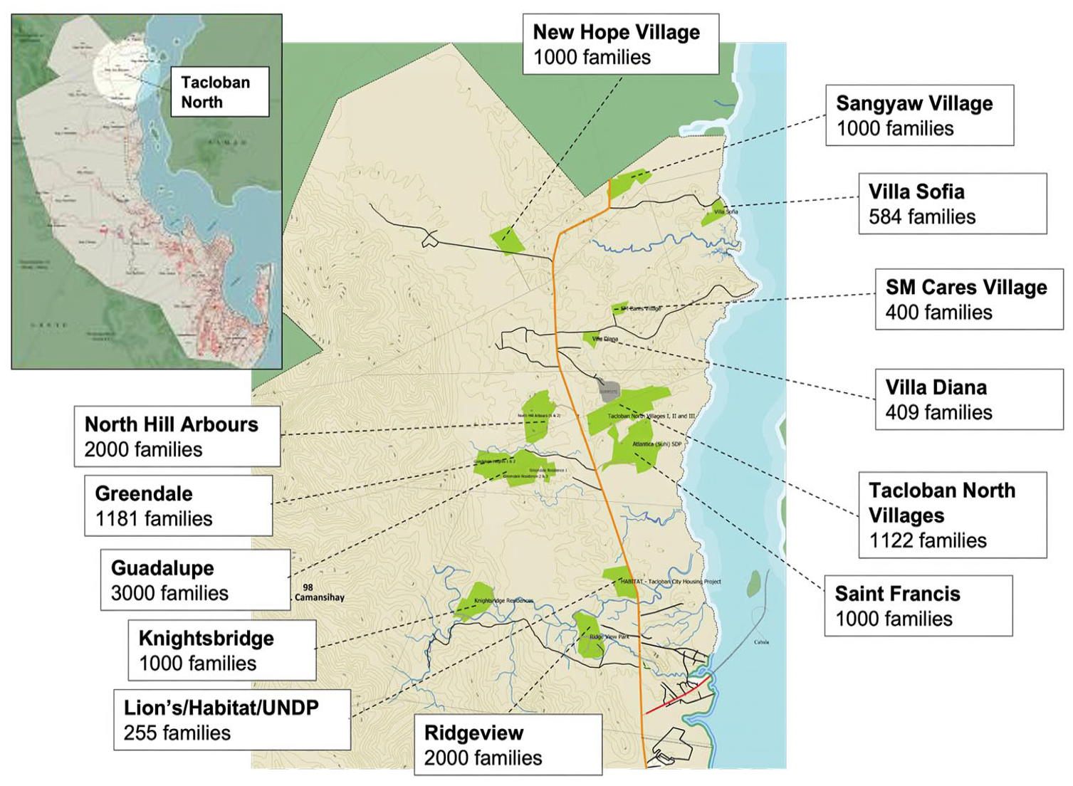
Location of resettlement sites.
The siting of Sendong relocation sites reflected a disaster risk–reduction objective through the transfer of residents from sites of greater to lower risk of natural hazards. In some instances, even the criterion of siting away from hazard-prone areas was problematic, as evidenced by a second relocation of 37 households out of their landslide-damaged relocation homes (Carrasco et al., 2016b). The state-led resettlement plan concentrated on building 11,225 permanent housing units, with humanitarian agencies building 86 percent of these units for households in relocation sites situated 7–20 km from their flood-affected homes (Dangol et al., 2020). Like in Tacloban, most sites were on land the city government had acquired prior to Sendong and zoned for social housing. Availability and expediency drove site selection, not criteria including suitability for building, established electricity and water infrastructure, or proximity to services, livelihoods and recreational activities, or beneficiaries’ preferences (Carrasco et al., 2016b, 2016c). Years later, access to key infrastructure and services remained unavailable (Carrasco et al., 2016a).
In Japan, prompted by the unprecedented devastation, the spatial forms and practices of disaster recovery were underlain by a shared desire of residents and national and local governments to distance people from future tsunami risk. Relocating residents was a tactic for establishing distance from hazards. Rebuilding plans began with tsunami simulation modeling and hazards and land use mapping. Unsurprisingly, engineering solutions were prioritized: (1) relocating communities to hillsides, (2) rebuilding on-site but on raised lands, (3) constructing massive coastal levees (MLIT, 2012a). The MLIT offered a collective relocation program for all Tohoku’s affected municipalities. It provided construction budgets and delegated to local governments the negotiations with residents and communities on land decisions, site design, and relocation processes. Implementation was expert-driven; national government officials provided technical and administrative support to local governments; local governments hired national consultants to develop land use maps incorporating the latest hazard models. Consultants designed relocation sites according to local governments’ preferences. The resultant relocation sites were built around the concept of saving physical lives without much input from the prospective relocatees.
The locations of the relocation sites, especially their distances from the city centers and sites for livelihoods, services, and social connection, have precipitated particular spatial practices. In some sites in CDO, for instance, residents integrated with surrounding communities, with children walking short distances to school, and adults engaging in local livelihoods. There were spatial practices spread over longer distances; for example, the daily exodus of workers commuting to former worksites and the weekly commute of some students who reside with acquaintances near their old schools for the school week. There was also an influx of non-residents including aid workers, government officials, church volunteers, construction laborers, and Catholic priests entering and exiting at various times to implement livelihoods-related programming, to build roads, to deliver Mass.
The approaches to resettlement and housing reconstruction laid conditions for the emergence of relocation sites as camps. In Japan, there were two types of government-mediated relocation processes. The extent to which residents shaped governance in each type affected the locations of relocation sites, which in turn affected relocatees’ abilities to continue their pre-tsunami way of life. Kesennuma City’s owner-driven “consultative relocation process” is the least camp-like of all the relocation sites studied. It targeted entire communities that lived together pre-tsunami, remained together in evacuation sites and temporary housing, and wanted to remain in close geographical proximity to their original neighborhoods. These communities organized relocation themselves, beginning with site selection. Community leaders drew upon pre-existing connections with the landowners of the desired sites for relocation, negotiating “easy” land transactions on the government’s behalf. These relocation sites are mostly on Rias coast hillsides, near the waterfront. Although relocatees must drive a few extra minutes to the ocean, residing near their source of livelihood (e.g. fishing) meant their way of life remained similar. In contrast, the “city-guided relocation process” targeted affected individuals and individual families. Prioritizing efficiency, the city constructed large apartment complexes accommodating more than 500 survivor households (Murosaki, 2021). Apartments were usually located in areas with good access to urban services—hospitals, schools, financial institutions. For many relocatees, this move to high-density housing away from the ocean significantly changed their way of life.
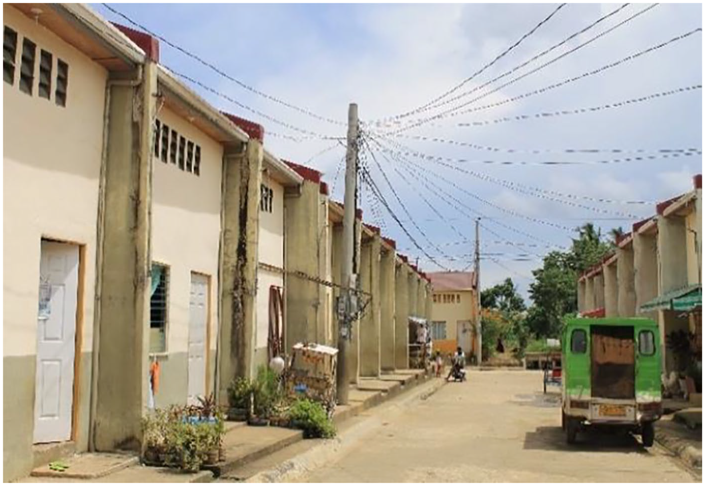
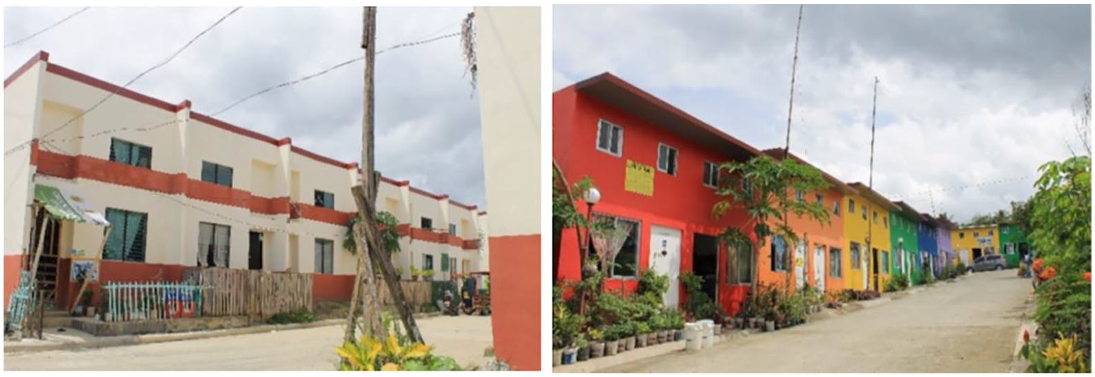
Tacloban’s government-enforced relocation sites used two main modalities, and in each one, it was non-residents who set limits on people’s mobility, their access to and control over resources, and their power to fulfill their interests and desires. First, “contractor-driven” housing overseen by the National Housing Authority (NHA) comprised most housing projects. In this approach, the NHA hired contractors to build houses in resettlement sites. It required the least participation from beneficiaries. The housing designs, mainly concrete row houses (Figure 2), were predetermined by the NHA. Housing units were awarded through a lottery in which eligible “beneficiaries” were randomly assigned a unit in one of several relocation villages. Hence, beneficiaries generally had no control over which house they would occupy, which village they would reside in, and who their neighbors would be. A second type of housing reconstruction approach is what Alburo-Cañete calls “donor-partnered.” This term refers to housing projects funded and implemented by international NGOs and private sector foundations in close partnership with the local government. Most donor-partnered housing was concentrated in one area and overseen by the city government. Unlike NHA-administered projects, donor-partnered housing designs varied according to the donor’s specifications (see Figure 3). Another key difference is that beneficiaries were asked to render 500–700 hours of manual labor or “sweat equity” as a condition for the housing award. Beneficiaries were assigned units, and like the NHA sites, they had limited or no choice. The control that donors and the NHA had over the form of relocation sites, and the positioning of the prospective residents as beneficiaries who ought to be grateful, facilitated camp-like governmental practices. Despite the aforementioned differences, the two housing approaches are similar insofar as (1) they imposed regimented housing, arranged in rows with streets designed in a grid; (2) there were social service facilities (although still under-staffed as of the time of data collection) and learning spaces/schools; (3) through their siting away from the city center and their lack of infrastructure, they imposed upon beneficiaries secondary disaster losses.
NHA housing project in Tacloban North.
Donor-partnered housing.
The most striking spatial form was the relocation housing unit. In Philippines and Japan sites, and like other relocation sites and camps more generally, these units were laid out such that outsiders can navigate within the site with the aid of a map. In Japan, survivors who chose public housing in the relocation sites lived in three- to five-story apartment complexes if the sites were in the city center. In rural areas, those in public housing lived in single-attached, duplex, and row houses. Those who built their own houses in the relocation sites also ended up having similar types of single-detached housing because, while there was flexibility in housing options, the government-allocated lot size (an average of 330 square meters) constrained design options. In CDO, units were designed as row houses, quadruplexes, and single-detached houses and built with durable materials such as reinforced concrete and steel sheets (Carrasco et al., 2018). Units met, or even exceeded, national minimum standards (Carrasco et al., 2016a; Dangol et al., 2020). Households received a “Certificate of Occupancy,” which accords them the right to reside in the unit for 25–50 years, but not formal ownership (Carrasco et al., 2016c). Residents may be evicted for violating occupancy conditions; for example, if they undertake certain renovations (Carrasco et al., 2016c). There were strict rules about allowable housing modifications—the kinds of extensions, the siting of modifications, the types of allowable materials—but rules were neither followed, nor uniformly enforced by government officials and implementing agencies. In this way, tenure insecurity is built into relocation site governance.
Various sets of rules dictated particular spatial forms and practices of relocations sites, which posed problems for residents, who in turn responded in various ways. For example, the stipulation in Japanese law that public money cannot be spent on individual assets indirectly contributed to variation in both the housing and population profiles within each relocation site. The law meant that each household must finance the construction of their house on a government-provided land parcel. Households with access to capital—wealthy residents and young families with active income earners—had more options. The small plot size, however, posed a problem: it was too small to store fishing buoys and nets. The same relocation sites also contained government-provided public housing units rented by families with financial difficulties. While housing materials were of good quality, most units were prefabricated, simple, and identical-looking one-story two-family attached homes. This difference in appearance between public and privately-owned housing created a sharp emotional divide; a public housing resident expressed that he felt his former neighbors with the new houses look down on public housing residents. The remaining residents needing to rent were housed together in large apartment complexes. Residents were mostly satisfied with their access to urban facilities, but their social networks were disrupted in the relocation shuffle. Many people, especially older residents, were reluctant to leave their new units to socialize and re-create social networks. As such, the city’s efforts to establish resident associations were thwarted by the emergent spatial practices of staying within one’s own home.
Rules governing daily life characterized the Philippine relocation sites, emphasizing their camp character. The Tacloban case provides a clear example. NHA or city government field staff had offices on-site for monitoring residents. Residents risked eviction if they did not follow strict occupancy rules. Rules spanned restrictions on house modifications, regulations on how long occupants can be away, observance of sanitation policies including restrictions on pets, and social conduct guidelines. Occupants were expected to participate actively in HOA that mainly ensured occupancy regulations were upheld, and in compulsory “volunteer work” (pintakasi) such as weekly cleanliness drives. Activities are supervised by government field staff, HOA officers, and designated “village coordinators,” who were housing beneficiaries themselves but deployed by the government to monitor occupancy. These forms of surveillance became embedded and embodied in the daily realities of housing occupants and were increasingly felt in terms of tighter regulations of movement and activities, referred to by study participants as “mga bawal” (prohibitions). As one study participant narrated: “In the village, damo nga bawal (there are many prohibitions). Cats are bawal, chickens are bawal, keeping birds is bawal . . . a lot of things are bawal, only people are allowed here (laughs).” This sentiment is echoed by another participant: “Damo nga bawal. Kulang na lang bawal huminga (there are so many prohibitions, what is missing is that they ban breathing too)!” Both study participants creatively use humor to emphasize constraints on their mobility and labor and on keeping animals for productive or affective purposes. This awareness and mockery are one starting point for resisting the strict occupancy rules. They hint at the not-so-subtle ways relocatees are governed as subjects inhabiting camp space.
Official state-led governance of relocation sites, supported by influential non-state actors, was informed by the politics of loss and enacted through processes of determining and implementing allowable particular spatial forms and practices. External actors largely understood relocation sites as “finished” projects once built spatial forms like relocation housing were completed and serviced. Yet, as described below, paralleling these official processes and discourse of “finishedness” was the emergence of alternatives. Such resistance reveals competing governance systems.
Resistance
The various ways relocatees, and occasionally officials, bent or outright defied rules demonstrates their recognition, and more importantly, their rejection, of resettlement sites as camp spaces that severely restrict agency. The observed resistance to the official governance system was less revolutionary and more mundane, akin to what James Scott (1985) describes as “weapons of the weak,” which are better suited for obtaining small material advantages in a context where overt contestation is dangerous. Disaster survivors’ resistance sought to materially and discursively improve individual and household situations and re-make their living environments around their desires. This re-making entailed acts that directly and indirectly challenged official state-led governance. In some cases, officials also contested elements of the formal disaster resettlement plans. While many survivors accepted government-sponsored relocation packages, they did not abandon their physical, economic, and cultural ties to their former homes. Instead, they reconfigured the physical structures and how they accessed them. Survivors also opened these spaces to other people and challenged official narratives that situated resettlement sites as progress toward safer, more resilient dwellings—thereby politicking their losses. In this way, their resistance critiqued post-disaster recovery processes that neglected affect and attachment to place, that severed ties between people and place, which facilitated “forgetting” in camp-like relocation sites. The empirical descriptions below support our argument that relocation camp governance is characterized as pluriform, not singular, as multiple actors vie for the power to govern, as well as unfinished or incomplete, as residents actively continue to remember their past, to reconfigure spatial forms and practices, or to circumvent imposed rules, structures, and systems perceived as unjust.
Survivors’ resistance did not emerge without warning in the resettlement phase of the disaster in the relocation sites. The CDO case is illustrative of how resistance initiated by survivors during their stay in evacuation camps persisted throughout their subsequent tenure in transitional housing, and later in relocation housing. While residing in Sendong evacuation camps and transitional housing sites, survivors participated selectively in job training and commemorative activities (Gibb, 2022a). Survivors might attend for any number of reasons: there was free transportation and a free meal; the event was located near the city center or their former neighborhoods, and they could visit nearby services, shops, and acquaintances; event attendees would receive a free livelihoods starter kit, cash or a zero-interest loan; they desired training in that particular livelihood. Survivors embraced particular spatial practices (of leaving the relocation site for sponsored disaster recovery activities) to access particular benefits (not necessarily the ones envisaged by the host organization), thereby thwarting the operationalization of particular governance objectives (of implementing organizations) as survivors exerted their own forms of governance via resistance. Another example of CDO survivor resistance was attempts to receive preferential treatment in relocation housing allocation. Notably, by having mothers with young children wait in long lines for relocation housing registration. Local officials noted it is normally the role of male household members to secure housing and strongly suspected that sending mothers was a strategy for preferential treatment. Other households adopted a split householding strategy to subvert restrictive eligibility criteria. Eligibility for relocation housing typically required a minimum stay in an evacuation camp, so household members deemed strong enough to endure the undesirable conditions spent the minimal period living there and sent other household members (e.g. children) to live with relatives in other parts of the city. Such resistance persisted in CDO’s relocation sites.
Once in the relocation sites, the rules and spatial forms that govern resettlement life provoked resistance. In the two Philippines cases, the governance of relocation sites was partly implemented through imposing particular rules, such as mandatory HOA membership and renovation restrictions. Yet, CDO’s relocatees reconfigured relocation housing units according to individual, household, and community preferences (Carrasco et al., 2016a, 2016b, 2016c; Gibb, 2022a). The primary reason for modifying housing, according to survivors, was to improve their quality of life (Carrasco et al., 2017). In Calaanan, CDO’s largest relocation site, Carrasco and colleagues (2016b) observed that between 38 and 69 percent of households undertook housing improvements. Doing renovations was risky. Tenure agreements permit only particular modifications, built with specific materials by or overseen by certified professionals. Anything else was deemed problematic and was subject to removal; as such, “unplanned” modifications were extremely tenuous. Some implementing organizations actively dissuaded residents from undertaking housing modifications, while others provided financial and in-kind assistance. Others, like Gawad Kalinga, took a laissez-faire approach, tacitly allowing modifications in the back of the units while prohibiting any visible ones from the road, suggesting that it was the appearances—the visible imprint of governance—that counted most. A similar approach was taken in Tacloban, with some residents openly defying renovations restrictions by modifying houses and building extensions—some of which were eventually demolished by the government.
Maneuvering around other regulations and restrictions governing daily life required creativity. In some Philippine sites, attempts to shape residents’ behavior were also done through on-site bans of pets, animals, videoke 5 machines, smoking, and drinking. Recall everything that Tacloban relocatees described as “bawal.” Residents were expected to self-police and enforce the bans. In CDO, such bans catalyzed the emergence of spatial practices whereby residents temporarily left the relocation site to raise animals or drink alcohol, and of spatial forms in which videoke bars were established just outside the site perimeter. In Tacloban, circumventing numerous bans on pets and livestock, for instance, led people to hide animals behind their houses. Such resistance thus became invisible but remained audible. Relocatees vacated (what officials regarded as) “clutter”—including laundry—from the front of their houses. “What can’t be seen won’t get you in trouble,” said one participant. It became an open secret that many housing occupants kept the bawal things out-of-sight and out of officials’ minds. As such, the desired governance of Philippine relocation sites, according to the state, remained contested and incomplete.
Another response to occupancy requirements described in the previous section was the emergence of novel spatial practices of residency via the establishment of “dual residences.” Here, housing beneficiaries maintained a resettlement site house and a second residence where they stayed most of the time (often a makeshift dwelling—see Figure 4) in their former neighborhoods near their livelihood. In Tacloban, this arrangement has been a great source of “headache” for government officials. 6 Such situations have compelled the Tacloban city government to undertake a cat-and-mouse game with so-called “hard-headed” beneficiaries, with parties employing strategies to outsmart the other. For example, the latter would leave the lights on in the empty houses to feign occupancy at night, while the former would conduct night “monitoring visits” to see if occupants are actually home. Residents would ask other non-family members to stay in the houses while they were away. Meanwhile, government officials would deploy HOAs to verify identities of housing occupants and so on. Some residents caught violating occupancy rules were evicted. While many Tacloban relocatees worked with and around occupancy rules, others pursued another form of resistance: abandoning their government-awarded houses to seek arrangements that better suit them and their livelihoods.
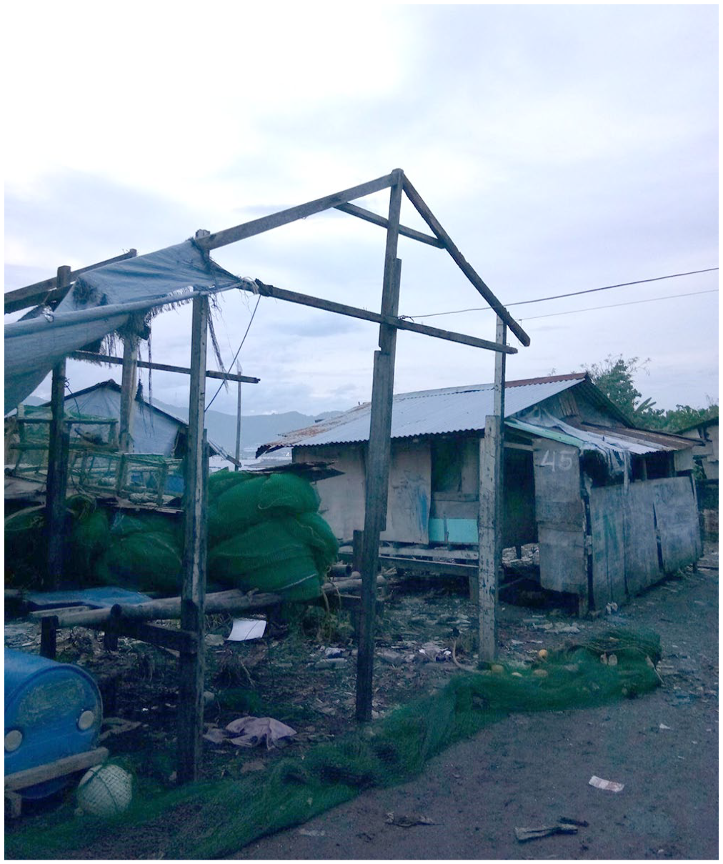
A makeshift dwelling built in the “danger zone” where residential housing was banned due to risks of natural hazards.
In both Philippines cases, survivors also contested the official narrative—the fantasy of achieving “better” (and “safer”) lives through resettlement began to fray as relocated survivors confronted the realities of living in these sites: inadequate livelihoods, no running water, high costs of living, fragmented support networks, and lack of basic freedoms such as being able to modify one’s own home according to one’s needs, keep animal companions, or move about as one pleases. In Tacloban, the construction of resettlement villages was heralded as “progress” and a step toward creating safer or “resilient” dwellings for affected communities, yet relocatees challenged these narratives. For instance, a study participant pointed to a photograph of row houses in a resettlement village and said:
This one, it looks beautiful, right? So beautiful. But if you live there, you will see that things are not so beautiful . . . the houses here are not well-made. We had an earthquake recently. The walls began to crack . . . Sometimes we just laugh “Yolanda didn’t kill us, but this house will when it falls on our heads.”
Such “jokes” elicited laughter and nods of agreement. However, these expressions can be interpreted as counter-discourses, a form of (subtle) resistance (see Scott, 1985), to state narratives of “building back better.”
The critique of the dominant narrative, however, was not an outright rejection of all the elements it espoused. Many interviewees in Tacloban considered concrete houses or balay nga bato desirable, noting they wanted to live in “safer,” “cleaner,” more “orderly” villages. While some have variably refashioned themselves to their new resettlement lives, embodying forms of responsibilities inculcated through various governmental mechanisms and regulations, there was also palpable uneasiness, discomfort, loneliness, and longings for a different way of being. As one participant, a widowed mother of four whose husband died in the storm surges, poignantly stated: “We are always gutom (hungry) . . . (gesturing towards the wall of her house) we have a concrete house, but we cannot eat it.” Another participant, who was a young solo parent, cried when she saw a photograph of a bird’s eye view of their resettlement village. She felt lonely looking at it because her parents were always away earning money while she was left alone in their concrete house. They experienced hardships at the relocation site because food was difficult to acquire because they had to buy everything: “We can’t have vegetables grow on concrete.” As such, resistance was not rejection.
In contrast to the Philippines sites, remembering emerged as the most prominent practice of resistance in Japan. Just as camps are governed to separate residents from their former lives, Kesennuma’s relocation sites engendered processes of forgetting. Yet remembering emerged as a critical component for disaster recovery, and strategies for remembering were deployed both collectively and individually. Illustrative of the importance of remembering is “the lost home project” (Tsukihashi, 2014). Two years after the tsunami, an architectural university network began creating miniature models of pre-tsunami communities (Figure 5). At this time, affected residents felt it was still too early to recall this “lost space,” and their initial engagement in the project was passive. It soon became a popular activity because it opened communication and reconnected neighbors relocated to different locations. People were excited about recording invisible memories about their homes and neighbors into visible miniature models displayed in community-gathering spaces. Through the affective process of collective remembering, Kesennuma relocatees realized they did not want to lose the spatial memories of their former lives. There was no time or space for valuing, or even acknowledging, such memories in the relocation sites.
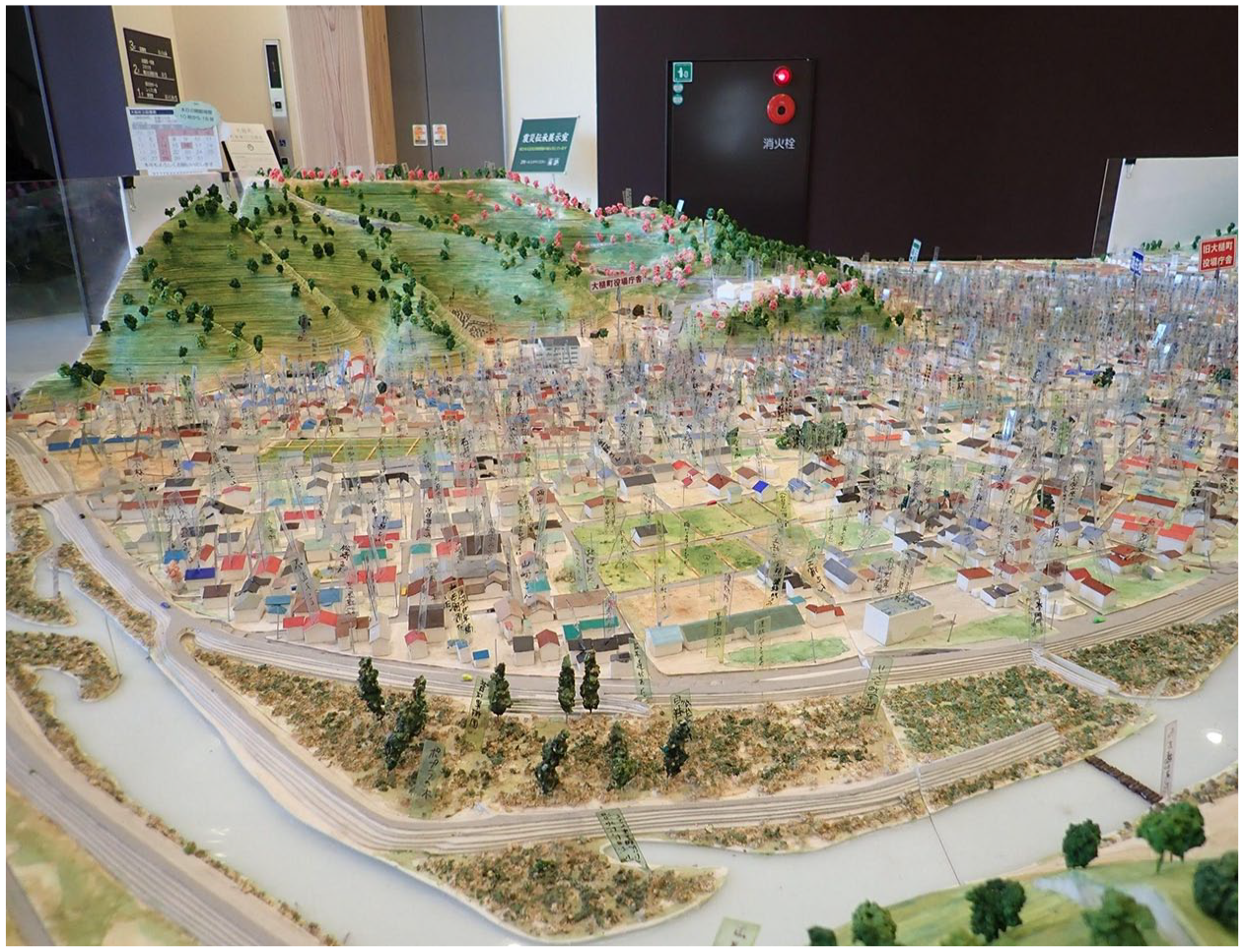
“The lost home project” in Otuchi Town community hall Oshacchi.
Like the lost home project, Tohoku survivors’ protests were rarely overt or directly defied disaster rebuilding plans. Rather, survivors worked within the boundaries of relocation policies, protecting the elements of loss they valued. This situation transpired among survivors whose structures were heavily damaged but left standing in the newly designated no-build, no major renovations “hazardous zone.” Here, former residents had to relocate. They could receive government compensation in exchange for giving up ownership of their structures and land.
In Japan, some survivors embraced a dual-residence approach, but unlike in the Philippines, it was less a strategy for securing governmental resources and more a strategy for remembering. Retaining ownership and adopting spatial forms and practices for remembering thus became a form of resistance. Kuniaki-san’s case is illustrative. Although he was relocated to public housing, his new space was purely for sleeping. He returns to the site of his old home nearly every day. Kuniaki-san rejected the government’s buy-out offer and instead repurposed his storage shed, the only remaining structure on his property, into Kaeru (“return” or “frog”), a structure “where you can be yourself” (Figure 6). It evolved into an informal communal space. Kuniaki-san estimates that roughly 20,000 students and young volunteers have stayed at Kaeru, for free, when they visited disaster-affected communities. Kuniaki-san teaches them about the emotional side of the tsunami, rebuilding, and post-tsunami life. The space has attracted visiting students from across Japan and young newcomers to the neighborhood who stop by to seek advice. A group of 10 young artists even painted a frog and cartooned Kuniaki-san on Kaeru to express gratitude and to release emotions about being unable to directly contribute to disaster-affected areas. Kuniaki-san did not expect his place would become such a community; his only motivation was to “fill his emptiness and loneliness” of all he lost. Looking back, he reflects that the years after the tsunami were “the best and featured decade of my life.” Two elements essential to Kuniaki-san’s post-disaster recovery—legal title to land and a focus on affect—are notably absent in the camp-like design of official relocation sites.
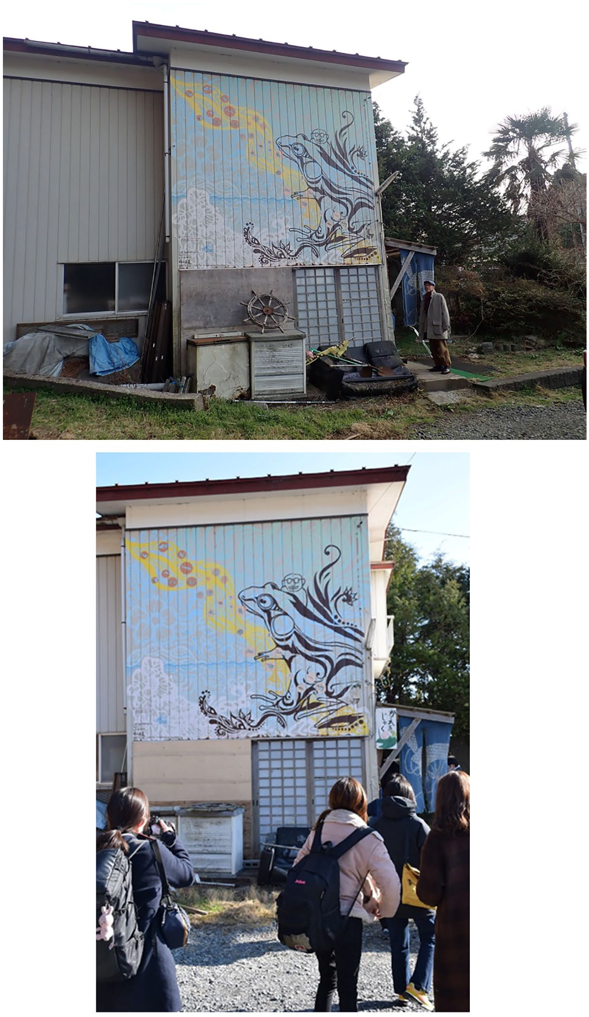
(Top) Kuniaki-san outside the Kaeru building. (Bottom) Students visiting Kaeru to learn from Kuniaki-san.
Shimizu-san similarly rejected the government’s offer to buy-out his inundated and uninhabitable home. Because the land was designated in a hazardous zone, and reconstruction on-site was prohibited, Shimizu-san had to demolish the house. He retained his land, and even converted the storage shed into a museum displaying equipment and tools used by his family for generations. He accepted the government’s request to indicate the height reached by the tsunami waves (Figure 7). The government identified his shed as an excellent structure for such signage because tourists staying in a famous local hotel on higher land right next to his, would see it. While supportive of the initiative to remember the tsunami experience in-situ, Shimizu-san quietly resisted the government’s relocation sites, whose designs separate relocatees from their pre-tsunami ways of life and constrain their agency. He disagreed with collective relocation; he wanted to decide where to live. So, instead of moving into a relocation site, Shimizu-san rented a private place using a voucher program for disaster-affected residents. After breakfast each day, he drives to his old place and stays until sundown. When the voucher program ended after 5 years, he lost all official post-disaster support because he was not a relocation site resident. To him, the resulting uncertainty on where to live “felt like a second disaster.” In another conversation, he reflected that it was only his memory-filled shed that enabled him to keep his spirit up. He recounted that while 34 percent of the families in his district had lost their homes and dispersed to various locations, people continued their solidarity. They individually and collectively came to his place for random talks. His old friends from elementary, junior, and high schools reunite at his place; they come in pursuit of maintaining their connections to the past.
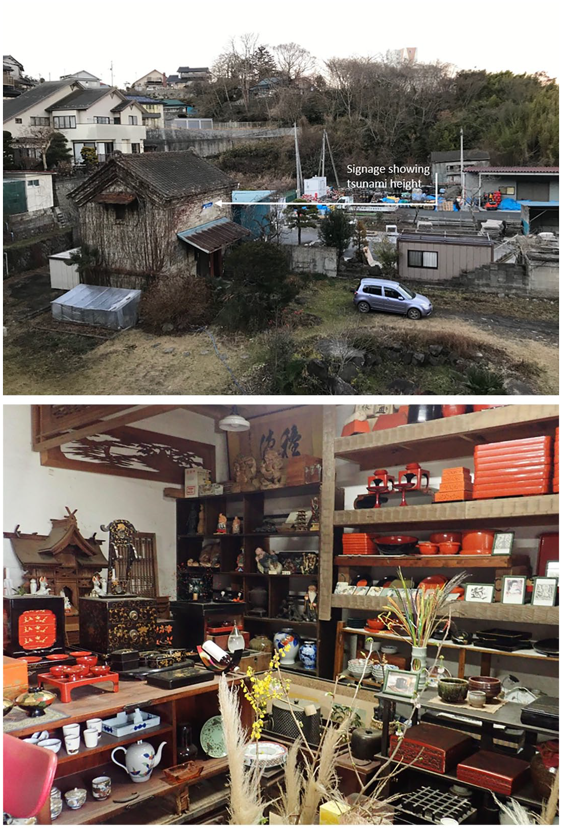
(Top) Shimizu-san’s former home in a designated hazardous zone. His car, for making the daily pilgrimage, is parked in front. The blue signage outside indicates the height reached by the tsunami waves. (Bottom) The antique collections inside the storage shed are intended to foster a healing process and a sense of connection to the past.
Before closing this section on resistance, it is important to point out that not all resistance was survivor-initiated and implemented, indicative of the multiplicity of governance actors and interests operating in resettlement sites. In some instances, government agency officials tasked with designing and implementing particular spatial forms and practices used their own on-the-ground observations and negotiated their adherence to official guidance. In both Philippines cases, for example, some officials ignored the maximum number of residents per unit to keep families together or avoided evicting households that did not meet the minimum number of nights per week in their relocation housing. In addition, in CDO, the Archdiocese responded to survivors’ requests for official documentation, pastoral care, “all-natural family planning” training, mass weddings, and mass baptisms. These elements were not part of the official disaster response and recovery plan, nor were they deemed essential to the proper governance of relocation sites. In fulfilling survivors’ requests, often in the relocation sites themselves, the Archdiocese showed the possibility for a more malleable governance that considers beneficiaries’ desires (and the Catholic Church’s interests), in addition to state interests. Also in Japan, local government officials and experts tasked with promoting hazard reduction have re-examined, with local survivors, the location of relocation sites and the size and form of levee construction to make it more attractive to live in. These instances of resistance enacted by officials and experts reflect an opening of possibilities, and a response to survivors’ claims for visibility and rights, and help explain why relocation sites were not built and operated exactly as originally intended. Such evidence further refutes governance theories presuming a singular governance with passive unquestioned acceptance of imposed systems, structures, rules.
Discussion: elucidating relocation camp governance
By interrogating the politics of loss, spatial forms and practices, and resistance, we have articulated a camp governance that, despite sharing characteristics with governance in other camp spaces, is emphasized in post-disaster relocation sites. These three analytical lenses are interwoven, creating gaps, constraining options, and shaping possibilities. The three cases show that the spaces earmarked for survivors enshrined governmental practices reflective of an institutionalized system established by official actors and continually reshaped by relocatees. The country differences underscore the salience of context to the ways in which these three conceptual lenses play out differently in post-disaster relocation, while remaining relevant levers for studying camp governance. Below, we bring the cases into conversation with each other and the broader literature to further elaborate relocation camp governance.
(Official) governance does not encompass everything. Rather, as Mucherera and Spiegel (2022) observed in Zimbabwe, it is selective in what it addresses, and what it dismisses. These decisions are partly pragmatic and limited by available resources. Critically, they are necessarily political and underlain with values about what is worth (re)building, for whom, where, and when.
In both Japan and the Philippines, the cases revealed a hierarchy of loss. As evident in the disaster response and recovery plans, losses and damages to housing, municipal infrastructure, and local and national economies were prioritized. Households were also slotted into a hierarchy of loss; in the two Philippines cases, for example, survivors were ranked according to purportedly objective categories of “flooded,” “partially washed out,” and “totally washed out” depending on what floodwaters did to their homes (but not to their belongings). Similarly, in Japan, the certificate of damage required to receive any type of government assistance, including housing assistance, had categories such as “total destruction, major destruction, and partial destruction,” which set limits on what and how much assistance could be provided. Thus, forced competition of “who lost more” was embedded in the official categories.
A broader conceptualization of well-being, as espoused by disaster survivors, was sacrificed. The “invisible” or “unnamed” losses, such as festivals, informal economy-centered livelihoods, care relations connecting people to others and their environment, ease of mobility in accessing livelihoods and social services, were neither measured nor folded into governance plans. The affective dimensions of loss, notably new framings of death, went unrecognized. Perhaps this absence could be taken as a positive insofar as these areas, deemed important by the survivors themselves, remain beyond the direct control of official state agents. Perhaps this absence suggests an opening for survivors to exercise agency. Yet, the act of relocation itself confers a loss of agency, a loss of “how to live,” and—contrary to the premise of relocation—a loss of safety and comfort.
Similar to other cases of post-disaster resettlement (Balachandran et al., 2022; Mucherera and Spiegel, 2022), official governance overlooked the aspirations of disaster survivors. This neglect is critical, for, as Alburo-Cañete (2021a) argues, aspirations chart pathways to recovery and thus shape governance decisions about how, what, and where to rebuild. The aspiration for “building back better,” a slogan for post-disaster reconstruction since the Indian Ocean tsunami (Clinton, 2006), which was then conceptualized and included in the Sendai Framework for Disaster Risk Reduction by the UNISDR (2015), draws on notions of (neoliberal) resilience and modernity. Imagining post-disaster futures in this way has led state actions, as most evident in the Philippine cases, to privilege certain pathways of recovery: urban renewal, revitalization of commercial centers, resettlement into concrete villages, order and sanitation, and most of all, “moral reformation.” Yet, while survivors’ aspirations might be entangled with state aspirations for recovery (e.g. receiving a concrete house and living in a subdivision-style settlement dovetail with survivors’ hopes for housing security), they do not always align. As evident in survivors’ narratives, the “resilient” good-life fantasy touted by resettlement is challenged by aspirations for sufficiency (capacity to meet their household’s needs, grow their own food, etc.), meaningful familial and place-based connections, social support networks, and fulfilling livelihoods. Not recognizing how such aspirations are crucial for recovery risks deepening vulnerabilities and exacerbating losses.
This discussion belies the linearity and one-dimensionality that conventional approaches depict disaster recovery to be. In contrast, we highlight how the interweaving of trauma, loss, hope, and aspirations shapes disaster response and recovery processes. This complexity, however, is not adequately captured in many research methodologies and planning practices (Alburo-Cañete’s (2021b) photokwento is a notable exception). For this reason, we have been deliberate in the starting point of our analysis and the issues we foreground: not to start with the hazard, as most disaster responders and planners do, but with the meanings that people attach to places, events, material forms, and relationships both extant and emerging, which all together paint a more textured picture of loss as well as the diverse acts of agency that are brought about in pursuit of post-disaster futures. For, as Kuniaki-san and Shimizu-san so aptly illustrated, processes and spaces for remembering the past and for acknowledging disaster-elicited emotions may be the same ones for collectively determining futures.
Evidently, there was a mismatch between what officials deemed essential to disaster recovery, and thus enshrined in their governance plans, and what survivors deemed essential. This gap links to the politics of loss and what remained unnamed and uncounted. It catalyzed resistance that undermined aspects of official governance plans. Relocatees’ resistance was often subtler and less confrontational than overt protests. It was enacted primarily through discourse and re-appropriation of space. In Tohoku, relocated survivors rejected the government’s buy-out option and asserted their claim to land by retaining their deformed structures on tsunami-affected sites. In Tacloban, relocatees lamented the “beautiful” relocation site rowhouses that hide “things [that] are not so beautiful” and joked about the inadequate housing quality. In CDO, residents renovated relocation housing to better suit household preferences, even at the risk of eviction for failing to adhere to the housing tenure agreement. In all cases, survivors themselves did not articulate these acts as resistance.
These different forms of resistance draw attention to another critical feature of relocation sites as camps. As introduced earlier, Picker and Pasquetti (2015) emphasize that camps are characterized as regimes of permanent temporariness, in their design and construction, as well as in the way they are experienced by residents. On the one hand, relocation sites would not qualify as camps because they are purportedly “finished” sites where residents have moved on with their lives. All the checkboxes on the lists of politicians, planners, humanitarian agencies, and others have been ticked, and a “durable solution” has been achieved; the “project,” in the eyes and project management systems of officials, is complete. Yet, the examples described in Part IV belie a discursive framing of relocation sites as “complete”; for example, the insecurity built into housing tenure agreements and the rules for occupancy and the lack of quality livelihood opportunities, amenities, and services in relocation sites required for permanent resettlement. In addition, the failure to consider the affective dimension of loss also produces relocation sites as spaces of permanent temporariness, as relocatees seek to maintain ties with their former social networks, homes, worksites, and ways of living through the creation of novel spatial forms and practices.
The official design of the spatial forms and practices of relocation sites was the purview of government actors and non-state actors contracted by government agencies to build the relocation sites. In all cases, relocation was about risk-averse spatial forms, in particular, housing, to be built efficiently. Relocation was not about survivors’ social, economic, cultural, and political lives. The rhetoric of participation remained unfulfilled in any agentive or decision-making capacity; in Tohoku, community involvement was “passive,” and in Tacloban, some housing recipients participated through “sweat equity.” Limiting the scope of relocatee participation to the physical construction of housing units points to the simplified camp-like character of these sites.
Despite the claims to prioritize safety (from hazards), violence was inherent to the sites’ governance structures. The lottery system for allocating relocation housing in the Philippine cases was violent because it tore apart families and communities, stretching tightly knit social networks to the breaking point. Officials’ attempts to reshape behavior and molding relocation site residents into good, responsible citizens were similarly violent. Attempts to create model development subjects were not made through physical violence, but through bureaucratic violence such as the disaster recovery plans that heralded the loss of particular ways of life and values (e.g. informality) and the large signs at the site entrances listing all the occupancy rules (see also Gibb, 2022b).
A final point to consider here is the attention that post-disaster relocation sites bring to the salience of the environment and the non-human in investigating camps. As noted earlier, the scholarly literature on camps is primarily focused on refugee camps, IDP camps, concentration camps, and work camps. Unsurprisingly, human-environment relations are less pronounced in camp literature. In contrast, the catalyst for creating a post-disaster relocation site is often a natural hazard, and a key criterion for its design is a site with a low natural hazard risk. Similar to Mucherera and Spiegel’s (2022) findings from flood-induced displacement in Zimbabwe, the importance of the environment and people’s relationships with elements of the natural world through place attachment, social activities, and livelihood endeavors also emerged as an important reason why relocation sites in Japan and the Philippines did not work out exactly as planned.
Our cases indicate another important point—that relocation camp governance itself is subtle, unlike the more overt official governance observed in camp forms such as the concentration camp and the refugee camp, or even the disaster evacuation camp. The subtlety of relocation camp governance is partly because relocation sites are construed as “finished.” That is, once residents move in, they move on with their lives. The governance of the relocation site and its inhabitants is subsumed within the governance of larger territorial units. Yet, as our cases reveal, relocation site residents themselves do not always concur with the finality of this assessment. Rather, they resist, thereby widening the governance structures operating within and beyond the site.
Conclusion
This article began with a provocation: post-disaster relocation sites are camps. Yet curiously, post-disaster relocation sites remain outside the purview of the vibrant camp studies literature and its theorizations of camps and their governance. This invisibility stems from a discursive framing of relocation as endpoint. As a “completed” project, resettlement supposedly marks the end of a journey wherein survivors’ everyday lives blend back into “normality” or even a “better” normal. The goal of our article was twofold: one, to encourage disaster scholars and practitioners to engage with the camp studies literature and to analyze relocation sites as camps, and two, to convince camp scholars studying other types of camps to consider human-environment relations more deliberately in their theorizations and empirical work. We deployed three conceptual filters to interrogate camp governance in post-disaster relocation: politics of loss, spatial forms and practices, and resistance. Through these lenses, we studied the assemblages of rules that shape resettlement site life; the unrecognized modes of meaning-making etched into these post-disaster spaces; the affects, emotions, and aspirations entangled in socio-spatial practices and encounters with material forms (such as a house); and the (subtle) forms of resistances to prescribed “ways to live.”
Situating post-disaster relocation sites as camps allowed us to scrutinize the governing practices that continue to shape socio-spatial and ecological relations as well as survivors’ subjectivities long after a “solution” to initial displacement has supposedly been attained through resettlement. By privileging the notion of “incompleteness” rather than “finishedness,” we gain a better understanding of the tangible as well as invisible forces that continually shape both disaster recovery efforts and the various regulations, negotiations, and resistances that take place within constructed post-disaster spaces. We hope that disaster scholars and practitioners build upon our project to engage with the camp studies literature and to analyze relocation sites as camps because such endeavors will contribute to more accountability and transparency among the people and institutions involved in disaster management, especially governing relocation sites that are designed to be and experienced as never truly “finished.” This assumption of finishedness limits opportunities for understanding how the construction of relocation sites (both physically and ideologically) carries through logics of camp governance, on one hand, and for expanding theories of camp governance to encompass the creation of these post-disaster spaces, on the other. Moreover, beyond its analytical value, a “camp” discursive framing of post-disaster relocation sites foregrounds the ongoing struggles and agentive aspiration-oriented acts of disaster survivors—elements that would otherwise be neglected, or worse, forgotten.
Footnotes
Funding
The author(s) disclosed receipt of the following financial support for the research, authorship, and/or publication of this article: Christine Gibb’s contribution to this article is based on fieldwork supported by the Fonds de recherche du Québec – Société et culture (FRQSC); the International Development Research Center (IDRC); the Canada Chair of Asian Research at the Université de Montréal. Kaira Zoe Alburo-Cañete’s contribution is supported by the European Research Council (ERC) under the European Union’s Horizon 2020 research and innovation program, grant agreement No. 884139. Kanako Iuchi’s contribution is partially based on knowledge gained from work funded by the Japan Society for the Promotion of Science, KAKENHI 20H02320.