
Abstract
Modifying the existing two-way street into a one-way street can alleviate the traffic congestion in a megacity and has the characteristics of economy saving, convenience, and quickness. However, at present, the setting of one-way street in China is mostly determined by human experience and lack of scientific basis. In this context, a one-way street network planning model is established in this paper. According to this model, the optimal method of adding a one-way street on the existing traffic network is found, solved by genetic algorithm. The abstract things are quantified, and some feasible, specific, efficient implementation steps to design a one-way street network are provided for the traffic control department. In addition, taking the traffic in the core area of Tongzhou New City as an example, this paper uses the one-way street planning model to construct the actual street network model and the one-way street network model in the core area of the Tongzhou New City and compares their simulation results. The results show that using the one-way street planning model to modify part of the two-way street into a one-way street in the core area of the Tongzhou New City can indeed improve the traffic operation of the area.
Introduction
With the development of society and economy, the number of cars in domestic cities continues to grow, and the traffic congestion index in major cities continues to rise. The growth rate of streets has already lagged behind the growth rate of vehicles. The existing streets cannot meet such a huge vehicle system, and the traffic congestion problem has seriously affected the development of cities and the daily life of citizens. 1 Scholars in the industry have been studying the problem of relieving traffic pressure in an endless stream. Among many methods of relieving traffic pressure, the method of changing two-way street to one-way street is often mentioned by traffic scholars.
One-way street refers to the street that can only drive in a single direction. In some narrow streets, in order to improve the road capacity and promote urban traffic microcirculation, one-way streets are sometimes set up to improve the road capacity, thus bringing about smooth operation of traffic flow. At the same time, traffic accidents can be reduced by reducing the chance of cross conflict. But it will also increase the detour distance of vehicles and cause-related problems, such as reducing the convenience of some lines of public transportation.
Zhuo and Wang 2 believed that one-way traffic organizations have the advantage of alleviating traffic congestion and facilitating implementation, but the traffic burdens such as bypass and end pressure may reduce traffic efficiency in a wider range. Miandoabchi et al. 3 found the optimal combination of one-way and two-way links, the optimal selection of network capacity expansion projects, and the optimal lane allocations on two-way links to optimize the reserve capacity of the network, and two new travel time–related performance measures.
Some scholars designed and solved the one-way street network model by traditional mathematical method. Salman and Alaswad 4 proposed a mathematical model based on Markov chain traffic assignment (MCTA) to optimize road network traffic patterns using maximum vehicle density through targeted direction conversions, that is, two-way to one-way flow conversions. A bi-level optimization programming model is proposed by Peng et al. 5 The decision-making variable of the upper level model is the scheme of one-way traffic reconfiguration, and the optimization target is to minimize the total travel time. The lower level programming is an equilibrium traffic assignment model. Using existing infrastructure, Kim et al. 6 proposed a model to optimize street direction to increase road network flow and obtained the optimal solution of the model by using simulated annealing algorithm. Xiao et al. 7 used a multinomial logit model to simulate the real situation of the flow space and the residence space of the traffic flow in the one-way street of the liberation West Road and give some reasonable suggestions to adjust the commercial entrance space of the liberation West Road. Wang and Zhu 8 analyzed the operation status of different forms of one-way traffic organization in the main urban area of Chongqing and concluded that the traffic network density and traffic network structure are the fundamental reasons for determining the effect of one-way traffic organization.
One-way street research is mainly aimed at reducing the number of vehicle stops, and at the cost of the length of the passage, travelers can get a shorter time and fuel consumption of vehicles. The most relevant thing to the vehicle stop time is the setting of signal lights. Bavarez and Newell 9 studied the effect of one-way streets on signal lights, including total delay and total number of stops. Khooban et al. 10 redesigned the current road links’ directions, expanded their capacity, and determined signal settings at intersections to optimize the reserve capacity of the whole system. Boyles et al. 11 proposed an equilibrium approach for evaluating the trade-off between increased distance and reduced intersection delay in networks of varying topology and demand patterns. Three control strategies are compared: two-way grids, one-way grids, and a vortex design with priority merges, with analysis of sensitivity to demand levels and other parameters.
Research on one-way street is not limited to theoretical models. Many scholars have considered more realistic issues. Guo and Zhu 12 used Baidu map API as a new data source for urban one-way traffic evaluation. Riggs and Gilderbloom 13 studied and tested the relationship between one-way street configuration and collision, crime, and community. Mao 14 conducted research on open and closed communities in the public to promote urban traffic microcirculation, increase the density and accessibility of regional traffic networks, and thus share the traffic pressure of major roads and strengthen the neighborhood communication. Aiken 15 used a one-way street to combine the environmental footprint of a community street with energy use. Miandoabchi et al. 16 considered both the total travel time and the total CO emissions as the two objective function measures and determined the optimal combination of one-way and two-way links.
Game theory is widely used in economics. Travelers choose a travel mode on the premise of considering individual economic benefits. The essence of it is a multiplayer game. Therefore, game theory is also used in the study of one-way street. Bianca and Coscia 17 dealt with the derivation and the analysis of a new mathematical model, modeled by stochastic games, for vehicular traffic along a one-way road obtained by the coupling of a uniform and an adaptive discretization. Zhang 18 used Braess’ paradox and road traffic ability to evaluate the impact of the opening of the urban microcirculation system on the surrounding roads in residential areas. Lykov et al. 19 proposed an N particles one-way street deterministic traffic model through a local controlled one-way street flow chart.
The implementation of one-way street has advantages and disadvantages, while the urban traffic network is a complex and huge system. Any change of traffic conditions may cause the change of the overall state of the network. Therefore, it is necessary to optimize the layout of one-way street in the network from the perspective of the overall network and guide the development of the street network traffic operation efficiency to the direction of benign. The traditional solution method has the characteristics of convenient and fast calculation, but the accuracy of the result is often limited, and the more precise calculation results push us to improve the traditional solution method. 17 In addition, considering the preciseness of the method, we should apply the model to the real street network to verify the improvement effect of the solution.
This paper has carried out a series of discussions and researches on establishment of one-way street to alleviate traffic pressure. Considering the balance between the reduction of vehicle stop and travel distance in the street network, aiming to maximize the relative total benefits obtained by travelers, a one-way street network planning model was established from the perspective of the whole network. We not only use the traditional genetic algorithm (GA) to solve the theoretical model but also try to use the simulated annealing algorithm to improve this solution. Using the proposed one-way street network planning model and improved GA, this paper designs a one-way street network in the core area of the Tongzhou New City in Beijing. The results show that, compared with the actual street network, the improved one-way street network panning scheme has promoted 22%, 20%, 9.23%, and 24%, respectively, in terms of the average number of vehicles passing, the average traffic volume, the average speed, and the average parking time, thus validating the effectiveness of this model. The rest of this paper is arranged as follows. In the next section, we introduced the establishment of a one-way street network planning model. In section “Using GA to solve the one-way street network planning model,” the method and steps of solving the planning model by GA are studied. Section “Applications” describes how the model derives the one-way street network planning scheme for the core area of the Tongzhou New City in Beijing and gives the empirical results to evaluate its performance. The general conclusion is given by section “Conclusion.”
Establishment of a one-way street network planning model
Table 1 lists the representation methods and meanings of important parameters in this paper. Considering the total benefit of the traffic network before and after the establishment of one-way street in a certain area, we establish a one-way street network planning model. In this paper, the corresponding evaluation indicators are selected from the beginning of the one-way street plan to the end of the vehicle running on the actual one-way street, including the construction cost of the street, the benefit of vehicle traffic, and the loss caused by vehicle parking. The objective function formed together represents the relative total benefit generated by the one-way street network in the region and also gives constraints on road traffic volume, street construction cost, and other aspects. 20 The one-way street network planning model is as follows:
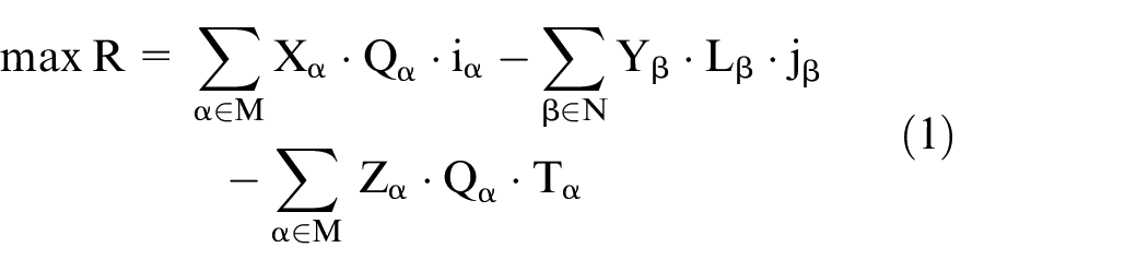
subject to
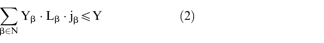


where
The notations of model parameters.

Using GA to solve the one-way street network planning model
GAs are widely used in the field of transportation. Song et al. 21 combined the micro-traffic flow model with the vehicle emission model to study the problem of the minimization of traffic emissions on the main road, proposed an optimal signal control model, and used the improved simulated annealing GA to solve the model. In the article by Rahmani et al., 22 the optimization problems of generation company and each distribution company were solved by GA and quantum-inspired simulated annealing algorithm, respectively. Yuan et al. 23 used GA to solve the dynamic control model considering lane signal merge. Zhao et al. 24 proposed a system design model for station site selection and vehicle deployment and used GA to solve the model. Ishikawa and Nakayama 25 used an absorbing Markov chain model to estimate the OD flows and estimated the transition probabilities of the unobserved nodes by GAs. In order to improve traffic operation efficiency, Mao et al. 26 studied the optimization of route length and number of road signs, and used GA to solve the mixed integer linear programming problem. Luo et al. 27 studied the optimization problem of dynamic bus scheduling with the goal of minimizing the total waiting time of bus passengers and used the GA based on memory initialization to solve the model.
Considering that the above-mentioned one-way street network planning model needs to compare the results of multiple one-way street network planning and has the property of evaluation, the GA just has the ability to simultaneously compare multiple individuals and the search for the results is also inspired by the evaluation function. So this paper uses the GA to solve the above-mentioned one-way street network planning model, the solution steps are as follows:
Step 1: Initialization.
(i) Determine the chromosome coding scheme. Each gene on the chromosome corresponds to the decision variable
Step 2: Chromosome repair. The chromosomes in the population that are not in the feasible domain are adjusted to ensure the feasibility of the population.
(i)
Step 3: Calculate the fitness of all chromosome.
(i) According to the chromosome coding scheme, update the layout scheme of the one-way street in the network. (ii) Traffic assignment for each one-way street plan. (iii) Calculate the objective function
Step 4: Update the population using genetic manipulation.
(i) Selection. Use the roulette method to select chromosomes for operation. First calculate the total fitness of all chromosomes
(ii) Crossover. Single point crossover using random number method. (a) Pair the selected chromosomes to obtain
(iii) Mutation. Uniform variation using random number method. (a)
(iv)Produce new population.
Step 5: Algorithm ends, when the maximum iterations has been reached, and the chromosome with the highest fitness in the output population is the optimal solution; otherwise, return to step 2.
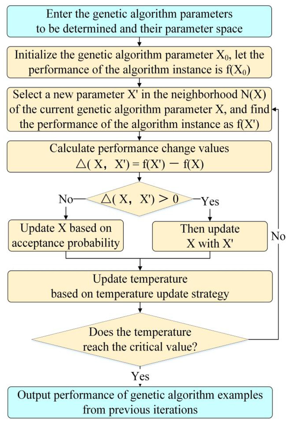
According to the algorithm designed above, the specific algorithm flow is shown in Figure 1.
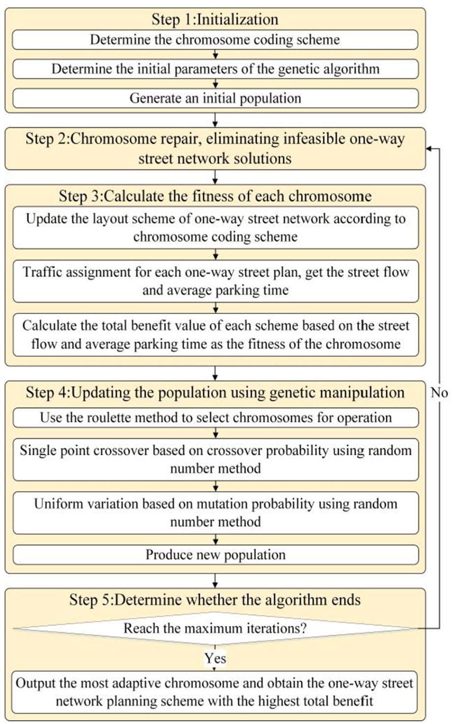
Process of genetic algorithm.
Applications
Core area street network data of Beijing Tongzhou New City
The core area of Tongzhou New City is the pioneering area, experimental area, and demonstration area of Beijing’s construction of a world city with Chinese characteristics. The government moved the location of the core area of the Tongzhou New City to the intersection of Wenyu River, Tonghui River, Yunchaojian River, North Canal and Xiaozhong River, with a planned area of 16 km2. According to the intersection, street, and OD data of the actual traffic network in the core area of Tongzhou New City, the street network model shown in Figure 2 is established by using Paramics simulation software.
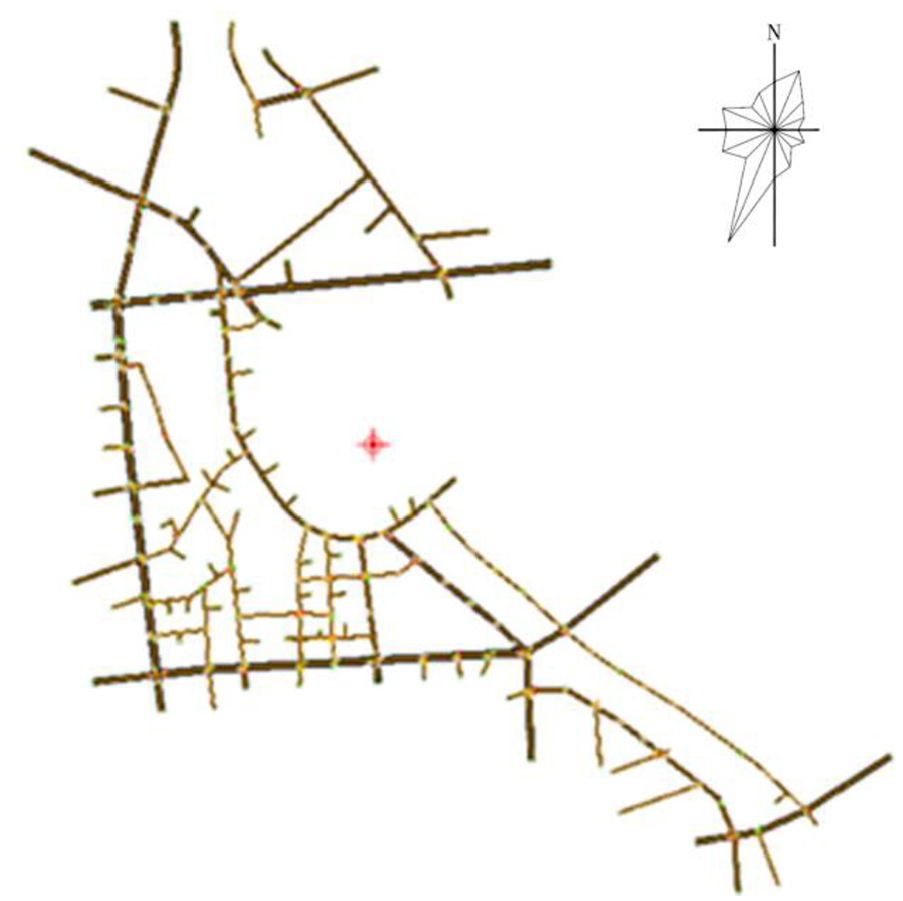
Actual street network model in the core area of Tongzhou New City.
The OD data are calculated based on the land type and the standard of Beijing traffic travel rate index. The land-type distribution in the core area of Tongzhou New City is provided by the school of urban transportation, Beijing University of Technology, as shown in Figure 3.

Land-type distribution in the core area of Tongzhou New City.
The land types include residential land, commercial land, public facilities land, medical and health land, industrial land, administrative and office land, education land, and so on. Land use data include land ID, land shape, building quantity, building height, number of floors, land length, land area, and so on. Each color in the figure represents different land use properties, and orange, which occupies a large area, represents class II residential land.
The Beijing traffic travel rate index was prepared by the Beijing Transportation Development Research Center. In the work of analyzing and processing a large amount of data, the Beijing traffic travel rate index obtains the average generation rate of traffic volume and the direction coefficient of traffic generation rate of the corresponding building properties in the morning and evening peak periods. The index relates to the amount of traffic travel generated by residential, office, and other sites. Through the impact indicators such as the building area (10,000 m2), the number of employees (persons), and the number of parking (vehicles), the average rate of traffic volume (vehicle/impact indicators) and the direction factor of traffic volume generation rate in the morning and evening peak periods are determined. Table 2 shows the traffic travel rate of the research and design office area. The other types of traffic travel rates are similar to the research and design office area. The specific conditions can be accessed online.
Traffic travel rate of the research and design office area.
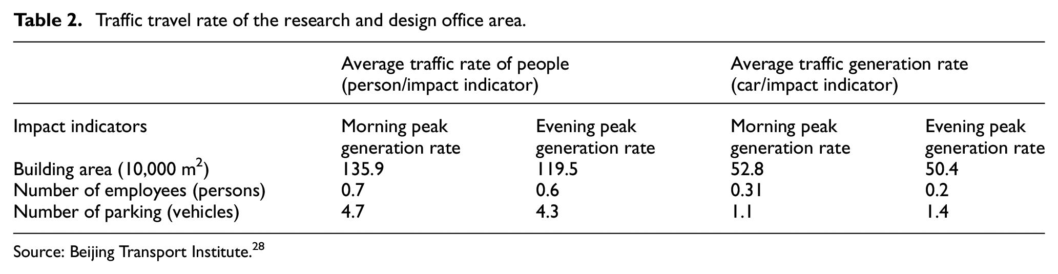
Source: Beijing Transport Institute. 28
Selection of GA parameters
Because the choice of parameters and the nature of the GA are the same, they are all the optimization process, so this paper thinks of applying the meta-heuristic algorithm to select parameters.
The heuristic algorithm includes meta-heuristic algorithm, which combines local search algorithm and random algorithm, and it includes GA, tabu search algorithm, simulated annealing algorithm, artificial neural network algorithm, artificial bee colony algorithm, particle swarm optimization algorithm, ant colony optimization algorithm, artificial fish swarm algorithm, and so on.29,30
Since no algorithm is optimal in all optimization algorithms, this paper selects the simulated annealing algorithm with relatively low computational value as the method to select the GA parameters. The core idea of this algorithm is to optimize the parameter group by replacing the “individual fitness” in the simulated annealing algorithm with the “performance of the algorithm instance corresponding to the selected GA parameter group.” The algorithm flow is shown in Figure 4.
Process of genetic algorithm parameter selection based on simulated annealing.
Parameters of the GA in this paper are optimized according to the order of crossover probability, mutation probability, population size, and termination iteration number. According to past experience, when applying GAs, the crossover probability is generally between 0.4 and 0.99; the mutation probability is generally between 0.0001 and 0.1, the population size is generally between 20 and 100, and the termination iteration number is generally between 100 and 500. 31 The initial values of the parameters selected in this paper are crossover probability 0.6, mutation probability 0.05, population size 60, and termination iteration number 300. The optimal solution found by simulated annealing algorithm is crossover probability 0.7, mutation probability 0.07, population size 65 and termination iteration number 280
Calculation result of GA
After selecting the parameters of the GA, the parameter results are substituted into the one-way street network planning model, and the GA is used to solve this model. The optimal result is shown in Figure 5. The optimal results suggest to modify the red street in Figure 5 to a one-way street, and the one-way street network obtained by this method has the largest total benefit.
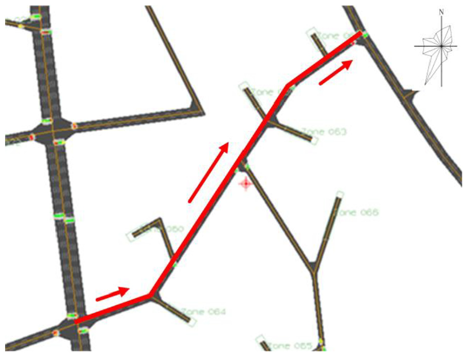
Optimal one-way street network result.
Model validation
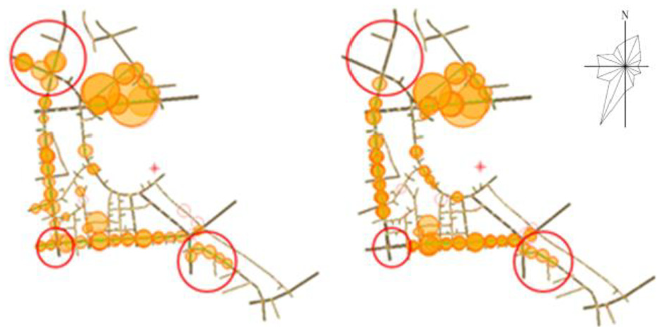
In order to verify the validity of the one-way street network planning model, this paper compares the optimal one-way street network planning model with the actual street network model through simulation. The congestion situation obtained by the Paramics hotspot viewer is shown in Figure 6. Figure 6 shows the street network congestion before and after the modification of the one-way street. The larger the area of the yellow circle, the more congested the street. The left and right sides of Figure 6 show the results after 1 h of simulation of the actual street network model and the optimal one-way street network planning model, respectively.
Comparison of simulation results before and after modifying one-way street network.
Observing the two figures in Figure 6, it can be seen that after 1 h of simulation operation, the yellow circle in the red area on the left is significantly larger than the right, which means that the actual street network model is more congested than the one-way street network planning model. This is because the modified one-way street attracts the traffic volume from the very congested arterial street on the left side of the street network to the street in the “L”-shaped area on the right side, thereby alleviating local pressure on the street and balancing the overall traffic distribution of the street network. It can be seen that the design of one-way street in the street network can not only change the traffic state of itself but also have a profound effect on the traffic distribution around it or even the entire street network. Therefore, a reasonable one-way street design is essential for traffic managers.
It can be seen from the red circle corresponding to the two figures in Figure 6 that the optimal one-way street network planning model can solve the traffic congestion problem to some extent. This verifies that the one-way street network planning model proposed in this paper is very practical for alleviating traffic congestion on existing roads.
In order to observe the street operation of the actual street network and the one-way street network before and after the improvement of GA more clearly, we use the data obtained from the Analyzer to compare the average traffic volume (Figure 7(a)), average speed (Figure 7(b)), average density (Figure 7(c)), and average delay time (Figure 7(d)) of the three street networks, and draw them into a line chart to observe the trend of the parameters during the simulation, and the results are shown in Figure 7. The three road network models are simulated by Paramics for 1 h, and the Analyzer collects data every 5 min. The horizontal axis of the four subgraphs represents the 12 time intervals divided, and the vertical axis represents the parameter values of each subgraph title. The actual network is the simulation result of the current two-way street network. GA and IGA represent the use of traditional GA and improved GA to calculate the one-way street network planning model to obtain the simulation results of the one-way street network.
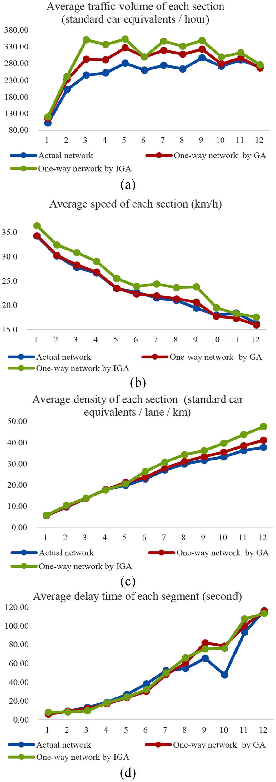
The parameter line chart before and after modifying the one-way street network. (a) Average traffic volume of each section (standard car equivalents/h). (b) Average speed of each section (km/h). (c) Average density of each section (standard car equivalents/lane/km). (d) Average delay time of each segment (second).
The results show that the average traffic volume and average speed perform better in the improved GA one-way street network, and the average density and average delay time are better in the actual street network. In addition, according to the data obtained by Analyzer, the improved one-way street network scheme has promoted 22%, 20%, 9.23%, and 24%, respectively, in terms of the average number of vehicles passing, the average traffic volume, the average speed and the average parking time compared with the actual road network. The overall performance of the one-way street network of the traditional GA is somewhere in between, which proves that the parameter selection improvement of the GA is of practical significance, as shown in Figure 7.
It is normal for the average density and the average delay time to perform better in the actual street network. Because vehicles in the two kinds of one-way street network models are affected by the one-way traffic, they have to make a detour, so the overall traffic volume of the one-way street network model under the same OD data is larger than the actual street network model, and the speeds of them are basically equal, according to the formula of traffic volume = vehicle speed × density, we can infer that the density of the two kinds of one-way street network models must be greater than the density of the actual street network model. As for the average delay time, the one-way street network model is to modify one of the two-way streets into a one-way street, in order to relieve the traffic volume in congested areas, then it will inevitably cause some vehicles to detour. The traffic in the whole area are in a state of congestion, the more vehicles go the longer average delay time will be, which results in the average delay time of the two kinds of one-way street network models is larger than the actual street network model.
Conclusion
Based on the consideration of maximizing the benefit of the traffic network, this paper establishes a one-way street network planning model and proposes a method for finding the optimal one-way street planning layout. It has achieved the greatest benefit in the absence of major changes to existing traffic network. Then taking the core area of Tongzhou New City in Beijing as an example, this paper verifies the model, uses the simulated annealing algorithm to select the parameters of the GA, substitutes this parameter to solve the one-way street network planning model. The simulation results show that the improved one-way street network planning scheme is better than the actual street network and the general one-way street network. Compared with the actual street network, the improved one-way street network scheme has promoted 22%, 20%, 9.23%, and 24%, respectively, in terms of the average number of vehicles passing, the average traffic volume, the average speed, and the average parking time.
The simulation results of this paper verify the significance of using simulated annealing algorithm to improve GA and the feasibility of one-way street network planning model. In addition, this paper also has some shortcomings, although the case in this paper confirms that the optimal solution obtained by the one-way street network planning model is indeed better than the actual street network and the general one-way street network. This does not necessarily apply to all traffic networks, it depends on the situation; according to the one-way street network planning model, the analysis is carried out step by step, thereby the result with strong reliability is obtained. This work will lay a foundation for studying the impact of one-way street setting on the network operation efficiency from the perspective of each traveler in the future.
Footnotes
Declaration of conflicting interests
The author(s) declared no potential conflicts of interest with respect to the research, authorship, and/or publication of this article.
Funding
The author(s) received no financial support for the research, authorship, and/or publication of this article.