
Abstract
The need to increase the amount of land under nature conservation at the national and global levels has gained attention over the past three decades. However, there are mixed reactions among stakeholders in South Africa regarding the establishment and expansion of cross-border nature conservation projects. Whereas conservationists and other white private landowners are in support of nature conservation projects, some white farmers are resistant to releasing land for conservation. The purpose of this paper is to investigate historical and contemporary reasons for farmers' resistance to conservation and to analyse the consequences arising from that resistance for the consolidation of the core area of South Africa's contribution to the Greater Mapungubwe Transfrontier Conservation Area. The paper argues that consolidation of land to create such special areas is a social process shaped through local contestation over land, power, and belonging. The study draws on fieldwork material from the South African section of the Greater Mapungubwe Transfrontier Conservation Area.
SANParks approached me to buy this precious piece of land in 1996. I told them that I was not interested in selling my land because I bought it for farming. You should tell them that I am still not interested in selling this piece of land and this land has no price. I would rather see my children taking over from me and continue farming than sell this land to SANParks. 1
Interview, commercial irrigation farmer 1 in Mapungubwe, South Africa, 23 July 2011. All quoted interviews in this article were conducted in English.
The above comment by one of the white landowners in the South African section of the Greater Mapungubwe Transfrontier Conservation Area (GMTFCA) was directed towards South African National Parks (SANParks), a statutory conservation body charged with protecting and managing the country's protected areas. 2 SANParks carries out this mandate in part by buying out land from private landowners in order to increase the number, size, and diversity of protected areas. The comment above is not only revealing in terms of the rights that property owners have over their property but it also demonstrates farmers' resistance to releasing land for initiatives such as the protection of nature, which is of national, regional, and global importance. This raises an intriguing question on how the resistance to releasing land by white farmers impacts nature conservation plans and goals.
The GMTFCA links the Northern Tuli Game Reserve (NOTUGRE) in Botswana; Mapungubwe National Park (a World Heritage Site), contracted freehold land that is not owned by SANParks but found within Mapungubwe National Park, and Venetia Limpopo Nature Reserve (all in South Africa); and Tuli Circle Safari Area, Sentinel Ranch, Nottingham Estate, and communal lands of Maramani, Machuchuta, and River Ranch (all in Zimbabwe).
The GMTFCA is one of several transfrontier conservation areas (TFCA) – popularly known as “peace parks” in the region and in other parts of the world – that emerged in post-apartheid southern Africa as the twenty-first-century approach for managing cross-border protected areas. In southern Africa, the primary driver of TFCAs is the Peace Parks Foundation (PPF), whose mission is to facilitate the establishment of these conservation areas and the development of human resources necessary to manage them (Peace Parks Foundation 2014, 2015). 3 The main reasons to create TFCAs include a desire to expand conservation areas in order to conserve biodiversity (Sandwith et al. 2001; Hanks 2003; Munthali 2007); to encourage socio-economic growth; and to promote peace and security (De Villiers 1999; Hanks 2003). As such, TFCAs have become an important aspect of environmental protection and received enthusiastic backing from a number of global actors ranging from the World Bank to environmental non-governmental organisations (NGOs), governments, conservation biologists, and park officials (Wolmer 2003; Duffy 2006; Ramutsindela 2007). TFCAs are, following International Union for Conservation of Nature (IUCN) classification, areas established in locations that span international political boundaries (Sandwith et al. 2001; Wolmer 2003). Thus, TFCAs recognise that conservation of biodiversity does not respect international borders, as such boundaries are political, not ecological (Singh 1999; Sandwith et al. 2001; Hanks 2003; Munthali 2007). Furthermore, it is argued that political borders, especially in Africa, were artificially imposed to serve colonial interests (Griffiths 1986). As a result, the ecological landscape in TFCAs are disrupted by borders and different land-use types that compromise the ecological integrity of the area. TFCAs aim to reinstitute this integrity by transforming state and property borders, effectively removing borders that are seen as fragmenting habitats. This goal has become an important argument in the promotion of TFCAs in post-apartheid southern Africa.
The Peace Parks Foundation is a non-governmental organisation that was formed on 1 February 1997 by the late Dr. Anton Rupert. The PPF was created to facilitate the establishment of transfrontier conservation areas in southern Africa.
The formation of TFCAs requires an amalgamation of a mosaic of land uses, often under various forms of tenure and across the borders of two or more countries, to create one conservation unit to be managed jointly by the countries involved. In other words, various pieces of land that could be state, communal, or private need to be integrated with the purpose of transforming the given cross-border area into a borderless landscape to allow free movement of wildlife and people (Griffin 1999; Hanks 2003). In this sense, the concept of TFCAs is explicitly based on the assumption by conservation management authorities that land for TFCAs is freely available across the border. However, this study argues that the land to be integrated into the TFCA must first be negotiated with private landowners. The study contributes to the literature on conservation and society by describing how white private landowners assert their authority and sovereignty over land earmarked for TFCAs and by elucidating the implications of that on the consolidation of the core area of South Africa's contribution to the Mapungubwe TFCA. The white private landowners affirm their authority by resisting both selling their farms to conservation lobby groups and signing contractual agreements with SANParks.
Resistance to TFCAs by white farmers is not new in the Mapungubwe area; rather, it dates back to the 1940s. The key research questions guiding the discussion of this paper are as follows: Why did white farmers resist conservation in the 1940s, and why are white farmers resisting conservation in the Mapungubwe area today? What were the implications in the 1940s, and what are the contemporary implications of resistance by white farmers to releasing land for conservation purposes in the study area? In working towards answering these research questions, the study begins by briefly discussing resistance. This is followed by an explanation of the study area and notes on methodology. In the third section, a detailed case study is provided on historical and contemporary resistance by farmers in the study area, while the last section summarises the study and draws conclusions.
Understanding Resistance: Power Relations and Inequalities
Scholars have used the term “resistance” to describe a wide variety of actions and behaviours at all levels of human social life (individual, collective, and institutional) and in a number of different settings (Hollander and Einwohner 2004). According to Ram (1987), resistance is a normal response to innovation. Taken a step further, resistance is based on a conscious choice (Szmigin and Foxall 1998). Other scholars describe resistance in the context of active efforts to oppose, fight, and refuse to cooperate with or submit to abusive behaviour and control (Profitt 1996). Given these conceptual variations, it is not surprising that there is little consensus on the definition of resistance. However, this study adopts Piderit's explanation, defining resistance as a multidimensional attitude towards change, comprising affective, cognitive, and behavioural components (Piderit 2000).
Existing literature on resistance (Ram and Sheth 1989; Szmigin and Foxall 1998; Kleijnen, Lee, and Wetzels 2009) suggests three forms of resistance to innovation: rejection, postponement, and opposition. As Szmigin and Foxall (1998) have noted, the most extreme form of resistance is outright rejection, which Kuisma, Laukkanen, and Hiltunen (2007) have defined as a passive form of behaviour resulting in an ultimate decision either not to adopt (or to ignore) an innovation. Rejection of innovation may stem from a perception that the given initiatives offer no worthwhile advantage to the people or communities (Western 1994; Szmigin and Foxall 1998; Kuhlken 1999), or that they may lead to marginalisation (Spierenburg, Steenkamp, and Wels 2006) or displacement of people (Brockington 2004; Sunseri 2005); alternatively, the innovation may be rejected because the people are reluctant to alter the status quo (Hirschheim and Newman 1988; Holmes 2007).
Communities may reject the establishment of a protected area by continuing to hunt, fish, log, farm, burn, or carry out other activities inside protected areas despite these being banned (Brockington 2004; Holmes 2007). This is what James Scott, in what is regarded as a landmark in resistance studies, termed “weapons of the weak” (in the book of the same name, Scott 1985). He describes how relatively “powerless groups” use anything within their power to fight against the rules and regulations imposed by governments or non-governmental organisations. For instance, in Kenya, the local Maasai herdsmen expressed their rejection of Amboseli National Park through the large-scale killing of wildlife, especially elephants and rhinoceros, while taking no meat, skins, horns, or other benefits and leaving the bodies to rot (Peluso 1993; Western 1994). In Tanzania, local communities or villagers rejected/resisted national park regulations that excluded them by cutting down trees recklessly without taking them, destroying forestry boundaries, grazing illegally, and threatening forestry staff (Sunseri 2005). Similarly, rural people who have lost control over the resources on which their subsistence traditionally depended have used fire as an indication of agrarian discontent and as a weapon of peasant resistance. This is illustrated by case studies from England, Algeria, and the southern United States (Kuhlken 1999). Research has shown that such rejections by local people often stem from attempts to change the nature of local community ties to the land (Peluso 1993; Brockington 2004; Sunseri 2005; Holmes 2007).
Resistance can also come in the form of postponement. In this scenario, although people may find an innovation acceptable in principle, they may decide not to adopt it at that point in time (Kleijnen, Lee, and Wetzels 2009). Kuisma, Laukkanen, and Hiltunen (2007) defined postponement as pushing back the timeframe of the adoption decision. As Szmigin and Foxall (1998) have noted, postponement most often appears to be caused by situational factors. This means that the decision is not final and if the conditions become suitable, such innovation may be accepted in future.
The final form of resistance is termed opposition, in which consumers are convinced that the innovation is unsuitable and decide to launch an attack by negative word-of-mouth (Kleijnen, Lee, and Wetzels 2009). In some cases, social “movements” or “associations” are formed to oppose an initiative (Taraki 1989; Stahler-Sholk 2001; Keisha-Khan 2004), whereas in other cases opposition is executed without any structure or identifiable leaders (Malseed 2008). As Malseed (2008) has noted, where there is no “movement,” opposition is more successful in weakening state control over land and livelihoods largely because their lack of formal organisation makes them difficult to target. Kuisma, Laukkanen, and Hiltunen (2007) describe this resistance as a form of protest against innovation, whereas Davidson and Walley (1985) explain this as innovation sabotage, where local people actively engage in strategies to prevent the innovation's success. An innovation that is opposed by certain people does not appear to offer those people, for whatever reason, a differential advantage that benefits them (Szmigin and Foxall 1998). In other words, innovation is opposed by people simply because they actually perceive a relative disadvantage bred by that initiative. For instance, a widespread lack of participation during the whole process of planning and implementing nature conservation measures is an important factor of opposition to the designation of protected areas in Germany. Opposition is expressed by local and regional authorities, particularly by mayors and other politicians, sometimes representing parties opposing the local or regional government, but sometimes even representing the governing party. This is because nature conservation regulations in Germany are perceived as restricting personal rights and private property rights (Stoll-Kleemann 2001a, b).
Study Area and Notes on Methodology
The study area is located in the northern side of South Africa and is part of the GMTFCA spreading into neighbouring Zimbabwe and Botswana. It is immediately south of the Limpopo River, which serves as the border between South Africa, Zimbabwe, and Botswana (Figure 1). The core area of South Africa's contribution into the TFCA is Mapungubwe National Park, which was declared a World Heritage Site by the United Nations Educational, Scientific and Cultural Organisation (UNESCO) on 5 July 2003 (Peace Parks Foundation 2012) due to the area's remarkable cultural significance in reference to the time between 900 and 1300 CE. Of particular interest are the Zhizo site 4 (900–1000 CE), located on farm Schroda; K2 or Bambandyanalo 5 (1030–1220 CE); and Mapungubwe Hill 6 (1220–1290 CE), situated on farm Greefswald (Huffman 2000; Carruthers 2006). Other properties forming part of the GMTFCA in South Africa include Venetia Limpopo Nature Reserve and contracted freehold land that is not owned by SANParks but found within Mapungubwe National Park (Figure 1). The South African section of the TFCA has a combined area of 55, 000 hectares.
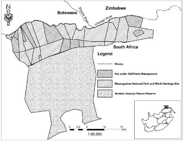
Location of the Study Area
Zhizo site, located on a slope overlooking the Limpopo River on the present Schroda farm in Mapungubwe, was the first capital of the Zhizo people.
K2 or Bambandyanalo was the second capital of the Zhizo people, located in present-day Zimbabwe, just north of the Limpopo River.
Mapungubwe Hill was the third site occupied by the precolonial state, located at the confluence of the Shashe and Limpopo rivers. The site was a trade hub connecting the African inland with the Indian Ocean.
The fieldwork that supports this article was conducted between 2011 and 2016 in the Mapungubwe area. In South Africa, all researchers who conduct research work in national parks are required to register their projects with SANParks. In adhering to this specific rule and research ethics in general, this project was registered and approved by SANParks. It was also discussed in the Trilateral Technical Committee (TTC) meeting of 8 June 2011 and was approved by committee members from three participating countries.
Interviews, observation, and documents constituted the main thrust of data collection. The informants of this study were selected using a purposive sampling approach. As Onwuegbuzie and Leech (2007) have noted, the researcher decides through purposive sampling which respondents can best provide the needed information. The informants were identified, selected, and interviewed until the point of data saturation. The sample for this study was drawn from informants that have a stake in the study area. Key selected informants included private landowners or farmers, SANParks officials, government officials, the international coordinator of the GMTFCA, donors, and conservation NGOs directly involved in the creation of the GMTFCA. A total of 46 informants were selected and interviewed in the study area, and the sample was comprised of 38 men and 8 women. The youngest participant was 30 years old and the oldest was 75. Semi-structured interviews were conducted with participants in their natural setting. Face-to-face interviews were conducted with informants, and the average duration of each interview was approximately one hour. These interviews captured local TFCA narratives, the process of establishing the TFCA, and more recent events concerning resistance by private landowners or farmers towards the establishment of the GMTFCA. The author also attended Mapungubwe Park Forum meeting with staff, private landowners, and local communities. 7 Field observations assisted in corroborating information provided in interviews.
The Mapungubwe Park Forum is a meeting that is constituted by representatives from the universities of Venda and Pretoria; SANParks; Vhembe district municipality; Blouberg and Musina local municipalities; DeBeers (Venetia Mine); private landowners; the South African Heritage Resources Agency; the Department of Sports, Arts and Culture; the Department of Water Affairs; the Roads Agency; and all other interested communities, including those that have lodged land claims in the UNESCO-recognised Mapungubwe Cultural Landscape. The Park Forum meets on a quarterly basis in the two municipalities of Musina and Blouberg as well as in the park itself.
Secondary data sources included historical and contemporary books, journals articles, historical reports, transcripts of parliamentary debates, minutes of TTC meetings, government reports, PPF reports and maps, Memoranda of Understanding signed by the three countries, and the integrated development plan of the GMTFCA. Transcripts of parliamentary debates and historical and government reports provided key information on resistance by farmers in the 1940s. Both primary and secondary data were analysed and synthesised to develop narratives that reflect historical resistance and its linkages to the current resistance by white farmers in the Mapungubwe area. These multiple sources of information provided a way to examine the reasons why white farmers resisted conservation in the 1940s, along with those factors that currently make white farmers resistant to conservation in the Mapungubwe area.
The Mapungubwe Situation
Historical Resistance by Farmers in the Mapungubwe Area
Resistance to conservation by white farmers in Mapungubwe is not new; rather, it dates back to a 1944 initiative by the government of General Jan Smuts (United Party) to establish the Dongola Wildlife Sanctuary. 8 The Welsh botanist Dr. Pole Evans, Smuts (then prime minister), and Andrew Conroy (then minister of lands) came to the conclusion that the area was not suitable for human habitation, and that saving the land from further ruin would necessitate a wildlife sanctuary for the recreation of the nation (Hansard 9 1945 cols 4670–4678; The Star 1945a). The aim of the sanctuary was to study the vegetation and assess its agricultural and pastoral potential (Carruthers 1992; Robinson 1996). The Dongola Wildlife Sanctuary was based on the original nine farms that had formed the Dongola Botanical Reserve in 1922 10 (The Star 1945a; Hansard 1947 col 12531). More farms were acquired and incorporated into the reserve, 11 and by 1945 the Dongola Botanical Reserve had grown from a small block of nine farms to the considerable area of 39 farms, totalling 72,000 morgen 12 (The Star 1945b; Hansard 1945 col 4683; SA LDE 1123 21439/29 13 ). The proposed Dongola Wildlife Sanctuary was to expand the Dongola Botanical Reserve to promote the conservation of the Limpopo River Valley west of Musina and to cover 123 farms with a total area of 240,000 morgen (The Star 1945a, b; Hansard 1945 col 4683). It was at this time that the possibility of linking the sanctuary with conservation areas in neighbouring Rhodesia (now Zimbabwe) and the colony of Bechuanaland (now Botswana) was first mooted (Hansard 1949 col 3387 and 3784; Sunday Tribune 1987; Hall-Martin, Novellie, and Knight 1994). It would have been the first formal tri-nation conservation area in Africa. Unfortunately, white farmers were resistant to the idea of a Dongola Wildlife Sanctuary at the confluence of Limpopo and Shashe rivers (The Star 1945b; Sunday Tribune 1987).
The United Party was South Africa's ruling party from 1934 to 1948, and the National Party was South Africa's ruling party from 1948 to 1994.
Name given to House of Assembly debates in South Africa.
The nine farms forming Dongola Botanical Reserve were Goeree, Dunsappie, Sharlee, Rosslynlee, Giesendam, Bruntsfield, Shelton Hall, Vernon, and Moerdyk (Hansard 1947 col 12531).
The farms that were incorporated into Dongola included Erfrust, Overvlakte, Bergen of-Zoom, Bismarck, Schrode, Weipe, Altenburg, Newmark, Hartjesveld, Haddon, De Klundert, Nekel, Hamilton, Kilsyth, Amersham, Chatsworth, and Greefswald (SA LDE 1123 21439/29).
A morgen is a measure of land equal to approximately 0.8 hectares.
SA LDE is the file name (source), 1123 is the volume number, and 21439/29 the reference number of the archive material. This archive material was found in the National Archives and Records Service of South Africa.
Resistance by white farmers intensified when two organisations, the Musina Dorsland Farmers' Association and the Musina Farmers' Union, resolved to protest against the idea of a sanctuary in the area. The resolution was also supported by the Zoutpansberg Farmers' Union. More petitions were drawn up in 1945 by the South African Agricultural Union and the Transvaal Agricultural Union to oppose the establishment of a sanctuary (Union of South Africa 1945; Hansard 1945 col 4691, 1949 col 3222). The principle grounds of opposition to Dongola Wildlife Sanctuary at the time were that Kruger National Park (KNP) was partly in the district of Zoutpansberg, less than 100 miles from the Dongola area and afforded ample facilities for the protection of all types of animal and plant life found in the Dongola Reserve; Dongola had little scenic interest for tourists and would not be able to compete with KNP and as a result would be a great burden for the taxpayer because no visitors would come; and big game conservation would be to the detriment of nearby farming operations (Union of South Africa 1945; Hansard 1945 cols 4687–4694, 1949 cols 3780–3782). In addition, landowners' interests would be prejudiced by unfair expropriation (Sunday Times 1944; Union of South Africa 1945, 1946; The Star 1945b; Hansard 1949 col 3217), and there was also a fear that diseases would spread amongst domestic stock (Union of South Africa 1945; Hansard 1946 cols 3914–3916).
Another attack to the proposed sanctuary came through an astonishing 14-page document entitled Homestead or Wild Animals under the auspices of the Musina Dorsland Farmers' Association. 14 The document accused Smuts and Conroy of hostility towards whites and preferring animals to humans (Anon. 1944; Hansard 1945 col 4785–4787). The document also criticised all aspects of the proposed Dongola Wildlife Sanctuary and praised the Dongola area as a paradise for both cattle raising and irrigation farming (Anon. 1944; Hansard 1945 col 4747; Union of South Africa 1946), as made clear by the quotation below:
The document was signed by S. J. Lombard, C. Chamberlain, Q. D. Cambell, A. B. Emery, and B. H. Ryder (Anon. 1944; Union of South Africa 1946: 399).
Dongola includes some of the best ranching land in the Transvaal. It is one of the few areas in the Union from which prime cattle can be marketed off the grass during the months of August, September, October and November. It is also suited for dairy ranching. At times of the year, and especially so in good seasons, considerable quantities of cream are sent by road motor service to Waterpoort or Musina, while a very considerable number of slaughter stock – both big and small – are brought to market each year. (Hansard 1945 col 4747; Anon. 1944: 7)
In one of the agricultural shows, held in South Africa in June 1944, the Zoutpansberg Review gave special praise to the high quality of the exhibits, particularly the livestock born and bred on the lands north of the Zoutpansberg, as made clear by the quotation below:
All the speakers agreed that the whole area was capable of producing very fine cattle. It was interesting to note that the first and second prizes were taken by the Afrikaner bulls born and bred in the area which is proposed to turn into a National Game Park. These bulls were fed entirely on veld without any stall feeding. Very fine citrus exhibits grown in the same area refuted statements made recently in a Magistrate Court by a high official of the Lands Department that the land was not suitable for settlers. (Anon. 1944: 11)
The subject of the Dongola Wildlife Sanctuary did not end with white farmers. Rather, the idea of a sanctuary and the development of a bill were hotly debated both in Parliament and in the press to the extent that it became known as the “Battle of Dongola” (Hall-Martin, Novellie, and Knight 1994; Robinson 1996; Carruthers 1992, 2006). It became the subject of political acrimony, with Smuts' United Party government in favour of the reserve while the opposition (National Party) was against it. During the debate in parliament, the National Party continuously made reference to Homestead or Wild Animals to argue against the establishment of the Dongola Wildlife Sanctuary (Union of South Africa 1946; Hansard 1945 cols 4702–4747). The Dongola bill was a “hybrid bill,” because private farms were to be expropriated. 15 As a result, a parliamentary select committee was established in 1945 to gather evidence from all the interested and affected parties. 16 The select committee produced two voluminous books, with one volume comprising 989 pages and the other 582 pages (Union of South Africa 1945, 1946). Whilst the committee ruled in favour of the proposed sanctuary, it recommended that the area allocated to the sanctuary be reduced from 240,000 to 92,000 morgen (Hansard 1947 col 11945). The land included in the sanctuary was the existing Dongola Botanical Reserve and the surrounding private farms that were not permanently occupied by the owners. Those farms that were occupied by the owners or caretakers were not included in the sanctuary as originally planned (Berry and Cadman 2007). According to Berry and Cadman (2007), the select committee reduced the size of the sanctuary on the basis that it was far too ambitious in scale. In addition, given the views of the opposing farmers and the existence of two million hectares in Kruger National Park, the committee felt that a smaller reserve was sufficient to fulfil the aims of the sanctuary.
A hybrid bill is a bill that would affect the general public but would also have a significant impact on specific individuals or groups.
Members of the select committee were D. Jackson (chairman), G. Henny, J. G. Carinus, H. J. Cilliers, Dr. H. O. Eksteen, G. P. Steyn, and J. F. Potgieter (Union of South Africa 1945, 1946).
Although the size of the reserve was reduced, the objective of the Dongola Wildlife Sanctuary “remains […] the protection and preservation, in the national interest, [of] the land comprised therein, its natural vegetation, wildlife and objects of geological, ethnological, historical or other scientific interest therein, and certain matters incidental thereto” (Union of South Africa 1946–1947; SA LDE 1122 21439/29). The recommendations by the select committee were debated in Parliament and approved 63 votes to 29 (Hansard 1947 col 12557). The governing United Party passed the legislation on 28 March 1947 (Dongola Wildlife Sanctuary Act No. 6 of 1947) (Union of South Africa 1946–1947; JUS 1658 1/186/47 17 ). The Dongola Wildlife Sanctuary Act, No. 6 of 1947, was published in the Government Gazette on 28 March 1947 and became law on 1 November of that year (Union of South Africa 1947). After that, a board of trustees was appointed (SA LDE 1123 21439/53) and Dongola was poised to fulfil the promise that Conroy, Smuts, and Pole Evans believed that it held. 18 However, this promise was short-lived: The victory of the National Party in the general elections of 26 May 1948 was a blow to the plan for the sanctuary, and the new government immediately cut off all funding for it and announced bluntly that it was to be repealed. 19 The idea to repeal the Dongola Sanctuary was debated in Parliament in April 1949, and the majority National Party quickly abolished the national park, which is what it had promised its supporters it would do (Union of South Africa 1949a; JUS 1600 1/146/43). The Dongola Wildlife Sanctuary Act was repealed by Act 29 of 1949, and the board of trustees was abolished (Union of South Africa 1949a: 252); money raised was repaid to donors, farms returned to the original owners, and the farms comprising the Dongola Botanical Reserve were allocated to white farmers by the National Party government (JUS 1600 1/146/43). The sanctuary had formally existed for a little more than a year and a half. Resistance and contests over land presented in this section were not on the basis of white vs. black opposition, but rather on white vs. white over the sanctuary idea. This raises an intriguing question: How much support would the Dongola Wildlife Sanctuary have generated had the land belonged to blacks rather than to whites?
JUS is the file name (source), 1658 the volume number, and 1/186/47 the reference number of the archive material. This archive material was found in the National Archives and Records Service of South Africa.
The board of trustees were Charles Gordon Saker, Dr. H. J. van der Bijl, Dr. B. Price, Senator John Stuart Franklin, and Sir Ernest Oppenheimer.
The National Party, headed by Malan, won 70 seats, whereas Smuts' United Party won 65 seats. This was followed by the Afrikaner Party, which won 9 seats, and the Labour Party, with only 6 seats (Union of South Africa 1949a).
Contemporary Resistance by Farmers in the Mapungubwe Area
Over the last two decades, Mapungubwe has undergone a transformation similar to that proposed by General Smuts – namely, the establishment of a TFCA at the confluence of the Limpopo and Shashe. When the idea of a TFCA emerged in the Mapungubwe area, SANParks responded favourably to the proposal for a number of reasons. First, they already had Mapungubwe National Park and saw the TFCA as offering an opportunity to increase the habitat size required by large mammals, particularly elephants. 20 Second, SANParks also viewed the creation of a TFCA as a way to conserve unique cultural resources and a landscape generally associated with Iron Age settlements from approximately 900 to 1290 CE. Furthermore, it is anticipated that the establishment of Mapungubwe TFCA will improve the tourism potential of the area, provide job opportunities to local communities, and boost the economy. 21
Interviews, park manager in Mapungubwe National Park, South Africa, 16 January 2012 and 14 January 2013.
Interview, Mapungubwe TFCA coordinator in Pretoria, South Africa, 22 March 2011.
The next step was consolidation. However, in the South African section of the GMTFCA, it is not only state land that is involved; in fact, the area is dominated by white private landowners, some of whom are resistant to the idea of the proposed TFCA, which makes it difficult to consolidate the core area of the South African contribution to the GMTFCA. Unlike historical resistance that led to the formation of an association to oppose or reject the idea of a TFCA in the area, the contemporary resistance by some local farmers has no formal association or movement. Instead, it is individual white landowners who are not interested in being part of the project, or in selling their land to conservation agencies, or in signing a contractual agreement with SANParks.
The consolidation of the core area of South Africa's contribution to the GMTFCA was dependent on two main processes: buying land, and negotiating contractual agreements with private landowners (Sinthumule 2014). The process of buying land to be consolidated into the park started in 1996. The farms that were bought and integrated into the park and TFCA included Den Staat, Hamilton, Welton, Samaria, Balerno, and Janberry. However, this approach of buying farms ran into difficulties, as made clear by one white game farmer:
The initial approach of SANParks was to buy all the farms in the core area. However, I was not happy with the idea of selling the land to SANParks because my family has conserved the land for ages. In addition, the farm was given to me by my mother and because of all the great memories we as a family and friends have enjoyed there over the years, this piece of land is so special to me. As a result, the relationship with SANParks was not that good. 22
Interview, game farm owner 1 in Mapungubwe, South Africa, 31 October 2011.
This became a stumbling block to acquiring much-needed land. The next option was negotiation with white landowners. According to these contractual agreements between SANParks and white landowners, SANParks takes full responsibility for conservation and management of biodiversity, but the ownership of the land remains in private hands. 23 In this logic, the contractual agreement does not completely remove property borders per se but only softens them, meaning that property owners still know where property borders are located even though the management of their land is shared with SANParks. The PPF, Rupert Family Foundation, De Rothschild Foundation, De Beers, National Parks Trust (NPT), and the World Wildlife Fund for Nature in South Africa (WWF-SA) assisted SANParks by facilitating negotiations with landowners to contract land to consolidate the core area of South Africa's contribution to the GMTFCA (Peace Parks Foundation 2006). For instance, De Beers Consolidated Mines committed their 36,000 hectare Venetia Limpopo Nature Reserve to the TFCA. 24 In addition, De Beers has leased four Schroda farms to be part of Mapungubwe National Park and the TFCA. 25 The agreement allows SANParks a 99-year lease for a one-off payment of ZAR 1,000 (Berry and Cadman 2007). In addition, Tuscanen, Rhodes Drift, Riedel, Little Muck, Armenia, and Mona farms, which were owned by NGOs such as the PPF, WWF-SA, NPT, and Friends of Peace Park, were leased and incorporated into Mapungubwe National Park and the TFCA. 26 It is important to note that these NGOs are behind the creation of the GMTFCA.
Interviews, park manager of Mapungubwe National Park in South Africa, 22 June 2011 and 14 January 2013.
Interview, conservation coordinator of De Beers in Johannesburg, South Africa, 30 June 2011; interview, PPF representative in PPF offices in Stellenbosch, South Africa, 28 February 2012.
Interview, conservation coordinator of De Beers in Johannesburg, South Africa, 30 June 2011.
Interview, PPF representative in PPF offices in Stellenbosch, South Africa, 28 February 2012; interview, Mapungubwe TFCA coordinator in Pretoria, South Africa, 22 March 2011.
Whilst some farms have been acquired and integrated into Mapungubwe National Park and the TFCA through contractual agreement, other private landowners whose farms are within the TFCA responded negatively to the idea of a TFCA in the region for a number of reasons. First, this group of white game farmers felt that the idea of a TFCA in the Mapungubwe area was imposed onto them by SANParks and the PPF without consultation. 27 Second, white game farmers feared losing important economic benefits from their property should their land become part of the park, such as being able to hunt and capture live wildlife. 28 Game farmers viewed game farming as the best land-use option in the Mapungubwe area, and they currently use their farms for live capturing of wildlife and commercial hunting activities, which are lucrative businesses, particularly in southern Africa. Unlike other white private landowners who have leased their land to SANParks, this group of white game farmers protect and manage their land, and their properties are surrounded by fences that separate them from conservation areas. 29 As a result, there are 10 white-owned game farms within the borders of Mapungubwe National Park that fall outside the management of SANParks and the TFCA (Table 1).
Private Game Farms within Mapungubwe National Park
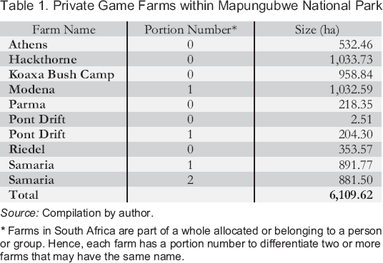
Source: Compilation by author.
Farms in South Africa are part of a whole allocated or belonging to a person or group. Hence, each farm has a portion number to differentiate two or more farms that may have the same name.
Interviews, various game farm owners in Mapungubwe, South Africa, 2011–2016.
Interview, game farm owner 1 in Mapungubwe, South Africa, 31 October 2011.
Interview, game farm owner 2 in Mapungubwe, South Africa, 31 October 2011.
The ownership of all the farms in Table 1 confers a bundle of rights to the owner, including the right to use the property as desired and to exclude others from its use. As Egan and Place (2013) have noted, under this model, property owners are seen as self-regarding, concerned only with their own interests and having limited obligations to those outside of their property borders. Under these circumstances, the availability of land and the possibilities for consolidating land largely depend on the willingness of powerful private property holders to release land for conservation of biodiversity through market transactions. In addition to game farms, white commercial irrigation farmers also resisted selling their land for conservation purposes. To date, the Mapungubwe area has 10 large-scale commercial irrigation farms within the borders of Mapungubwe National Park and the TFCA (Table 2).
Commercial Irrigation Farms within Mapungubwe National Park
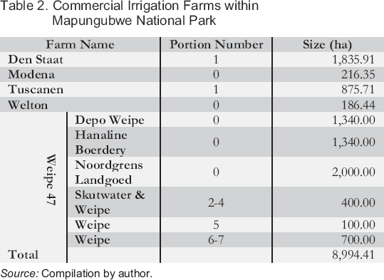
Source: Compilation by author.
The commercial irrigation farms appearing in Table 2 are surrounded by electric fences that separate them from conservation areas. Just like game farmers, irrigation farmers also have property rights over their land that allow them to use the land as they wish. The 10 farms constitute 8,994.41 hectares of land currently used for farming by irrigation farmers in Mapungubwe. Tuscanen, Welton, Weipe, Skutwater, and Hanaline Boerdery are commercial vegetable farms whose main crops include tomatoes, onions, sweet potatoes, pumpkins, watermelon, butternut squash, and potatoes. 30 Modena, Depo Weipe, and Noordgrens Landgoed are commercial citrus farms, whereas Den Staat is used for both citrus and vegetable farming. 31 All white commercial farmers that were interviewed claim that Mapungubwe is the best agricultural area in the whole of South Africa. 32 As one informant recounted,
Interview, commercial irrigation farmer 1 in Mapungubwe, South Africa, 9 January 2012.
Interview, commercial irrigation farmer 2 in Mapungubwe, South Africa, 9 January 2012.
Interviews, various commercial irrigation farmers in Mapungubwe, South Africa, 2011–2016.
The soil and climate in this area is conducive for growing vegetables and citrus. Citrus fruits and vegetables are not affected by insects because the area is dry and warm and receives just a little amount of rainfall. Frost is also not common in Mapungubwe, making the area ideal for planting vegetables, particularly tomatoes. The area also has an abundance of water for irrigation from Limpopo River. You cannot suffer from hunger in this area. 33
Interview, commercial irrigation farmer 3 in Mapungubwe, South Africa, 9 January 2012.
As result of these conditions, white farmers in the Mapungubwe area claim to produce the best-quality citrus and vegetables in the country. Citrus fruits produced in Modena, Depo Weipe, and Noordgrens Landgoed are therefore exported to Europe. 34 Consequently, irrigation farmers in Mapungubwe have no intention of giving up their farms, because farming conditions are favourable and economic returns are good.
Interview, farm manager 2 in Mapungubwe, South Africa, 23 July 2013; interview with commercial irrigation farmer 3 in Mapungubwe, South Africa, 9 January 2012.
Though property border transformation occurred (only for those farms that have been bought or leased to SANParks) in the Mapungubwe for purposes of conservation, commercial irrigation and game farms are still bordered by fences. The border fences can be understood as affirming the ownership and integrity of commercial irrigation and game farms. In this context, fencing performs a dual function of securing property and restricting the movement of wildlife. The implication is that human-imposed fences have disjointed the conservation habitat in the Mapungubwe area and hinder the free movement of wildlife. In other words, resistance by white game and irrigation farmers within the conservation areas has highly fragmented the area ecologically (Figure 1). This results in a reduction of habitat, an increase in the number of habitat patches, a decrease in the average size of a habitat patch, and an increase in the isolation of patches (see Fahrig 2003; Bennett 2003; Hilty, Lidicker Jr., and Merenlender 2006). Whereas TFCAs are premised on transforming state and property borders and the need to reconfigure transnational spaces into a borderless landscape (Singh 1999), game and irrigation fences challenge the whole idea of turning Mapungubwe into a TFCA. In addition, despite the change in the ownership of the farms over the years, the current viewpoint of farmers, similar to the viewpoint shared by farmers in the 1940s, is that the Mapungubwe area is more than suitable for farming. However, the conservationists are of the view that conservation is the most suitable use of land in the Mapungubwe area (Sinthumule 2014). This difference of opinion threatens the creation of Mapungubwe as a TFCA and has led to competition over the use of land (Sinthumule 2016). In the case of Mapungubwe, farming and conservation are competing for the same piece of land and the competition has yet to be resolved.
Conclusion
In this study, I have used the South African section of the GMTFCA to demonstrate that TFCAs are not constructed in a vacuum; rather, they are established where there are people who also have an interest in the land and its resources. For instance, in the Mapungubwe area, the land earmarked for TFCA represents, for white landowners, the main source of their livelihoods, an investment opportunity, familial territory, and home infused with deep memories. Given the values that people attach to their land and the area as a whole, it came as no surprise that white farmers resisted conservation in the 1940s and are currently still resisting releasing land for conservation purposes. White farmers resisted the idea of a TFCA in the 1940s because they were against the notion of land expropriation, which was anticipated to have a detrimental impact on food production, whereas the contemporary white farmers are resisting the idea of a TFCA because they could lose important benefits such as being able to hunt and capture live animals, and generating good revenues from irrigation farming. In other words, white farmers are resistant to the idea of establishing a TFCA in the area because conservation of biodiversity does not offer any valuable benefits to them. In the 1940s the TCFA was dissolved, whereas currently, despite the re-establishment of the TFCA, the existence of private farms within the conservation area has resulted in land-use conflicts and habitat fragmentation.
This study has also demonstrated that the consolidation of land to create TFCAs is a social process shaped through local contestation over land, power, and belonging. For instance, the white landowners have property rights that empower them to have control over their land. As Nedelsky (1990) has noted, property rights on private land or farms serve as a source of security whose sacredness acts as a barrier even to the power of the state. Conservation lobby groups' dreams of creating TFCAs have been contested and challenged by private landowners. In this logic, private land can be defined as space not controlled by a government where farmers or private landowners re-affirm their authority and sovereignty over that land and its resources. The ongoing struggle over geography in Mapungubwe highlights the contention over who can legitimately claim “ownership” over certain spaces and who can control how lands are used and governed. This battle has intensified the tension between white private landowners and conservationists. The assumption that various pieces of land under different forms of tenure can be easily integrated into TFCAs and other conservation areas is deeply problematic.
Documents
Hansard (1945), 4 April, cols 4670–4678.
Hansard (1945), 4 April, col 4683.
Hansard (1945), 4 April, cols 4687–4694.
Hansard (1945), 4 April, col 4691.
Hansard (1945), 4 April, cols 4702–4747.
Hansard (1945), 4 April, col 4747.
Hansard (1945), 5 April, cols 4785–4787.
Hansard (1946), 20 April, cols 3913, 3943.
Hansard (1946), 20 April, cols 3914–3916.
Hansard (1947), 4 February, col 11945.
Hansard (1947), 12 February, col 12531, 12557.
Hansard (1949), 31 March, col 3217, 3222.
Hansard (1949), 5 April, col 3387.
Hansard (1949), 11 April, cols 3780–3782.
Hansard (1949), 11 April col 3784.
JUS 1600 1/146/43 Dongola Wild Life Sanctuary Repeal Bill 1949.
JUS 1658 1/186/47 Dongola Wild Life Sanctuary Act Number 6/47.
SA LDE 1122 21439/29 Dongola Botanical Reserve Wildlife Sanctuary Bill of 1947.
SA LDE 1123 21439/29 Dongola Botanical Reserve Wildlife Sanctuary Bill Act of 1947.
SA LDE 1123 21439/53 Dongola Sanctuary Board of Trustees of 1947.
SA LDE 1123 21439/53 Dongola Sanctuary Board of Trustees 16 September 1947.
Footnotes
Acknowledgements
I acknowledge all the respondents in Mapungubwe who participated in this study between 2011 and 2016. I also gratefully acknowledge the University of Venda, particularly the School of Environmental Sciences, for the support they have given me throughout the process of data collection and analysis. This work is based on the research supported in part by the National Research Foundation of South Africa Unique Grant Number 99306, for which I am thankful.