
Abstract
In recent years, wireless sensor networks have been widely employed in monitoring agriculture. With social development, large-scale agriculture monitoring by satellite sensor network attracts increasing concerns as well as the transmission problem of plentiful agriculture data. In this paper, we propose a new method of constrained route based on the metric of delay and capacity (CR-MDC) to find route path in satellite sensor network, with the aim of achieving congestion avoidance of network for transferring a large amount of data while monitoring large-scale agriculture. We model the rosette constellation network according to network characteristics through a discrete-time figure and formulate the scheme as a binary integer programming problem in consideration of time-variant parameters, for example, link capacity and link delay. The performance of the constrained route algorithm is compared with the Dijkstra-based routing protocols proposed in existing literature. Moreover, an improved CR-MDC under a route similarity constraint is developed to reduce the handoff times in adjacent slots. Simulation results show that the proposed scheme exhibits lower blocking probability and maximum link utilization but higher average network delay than Dijkstra-based routing while the improved CR-MDC has a higher route similarity than CR-MDC.
1. Introduction
Agriculture is the foundation of human life. Roughly 37% of earth's land is today employed for agricultural purposes, with about 11% used for growing crops and the reminder for pasture. However, with increasing population throughout the world and the need for increased agricultural production, the improved management of the world's agricultural resources is required. So reliable and timely information about not only the types, but also the quality, quantity, and location of agricultural resources is quite necessary for the countries which take agriculture as main financial source, which can assist in making timely management decisions that affect the outcome of the current crops. Wireless sensor networks (WSN) have been applied to agriculture for collecting those agricultural data for a long time, such as agricultural irrigation, fertilization, pest control, greenhouse cultivation, and livestock breeding, due to the small size and facile deployment with no need for manual intervention. However, it is quite hard to obtain information of large-scale agriculture for traditional WSN due to the limited energy and deployment area. But it is necessary to monitor and regulate large-scale agriculture for production increase. Satellite sensor network provides information collection and supply in large-scale time and space and enhances future WSN-based applications with various requirements of quality of service (QoS) [1]. But enormous amounts of data transferred on satellite sensor network for the large-scale monitoring may result in link block and network congestion that affects the data reliability with the change of the link capacity and delay over time because of the fast-movement of the satellites. Therefore it is greatly significant to study how to avoid congestion of the satellite sensor network in agricultural application.
In this paper, we modeled the satellite sensor network through a discrete-time figure in agriculture and proposed a new method of constraint route to avoid congestion. The remainder of the paper is organized as follows: in next section, we review the applications on agriculture of wireless sensor network, including the ground wireless sensor network and the satellite sensor network. Low orbit sensor-equipped satellites can provide high resolution image of agriculture and satellite constellations achieve a quasi-instantaneous global coverage [2]. Thus, a low orbit rosette constellation is chosen for large-scale agriculture monitoring. And in Section 3, the characteristics of the LEO (Low Earth Orbit) rosette constellation have been discussed. The CR-MDC aimed at avoiding congestion is proposed in Section 4, according to the change of the distance and propagation loss of the satellite link. Section 5 presents the performance evaluation of the route and the improved CR-MDC followed by the conclusion in the last section.
2. Related Work
2.1. Ground Wireless Sensor Network for Agriculture
Ground wireless sensor network has been applied to obtain agricultural information in real-time in agriculture since 1990s [3], such as precision agriculture, smart agriculture, and information-intensive agriculture [4]. The information of weather, soil moisture, and crops growth is accumulated from sensor nodes arranged in the monitored area, which is used to help regulators find existing problems timely and position problematic area precisely. These data, in turn, influence management and policy decision-making. So, agricultural services like irrigation, fertilization, pest control, greenhouses planting, and animal and pastures monitoring are all taken into consideration in application domain of ground wireless network.
Lots of literatures reported how to utilize the WSN to improve irrigation in agriculture. Those studies in [5–9] constructed different agricultural irrigation systems to control irrigation valves and adjust the irrigation frequency and intensity with the information collected by wireless sensor network. The wireless network also has been widely used in fertilization, pest control, and greenhouses cultivation. For instance, in [10], an automated fertilizer applicator was built using the information of plants collected and analyzed by GPS technology, real-time sensors, and Bluetooth technology. The applications of real-time sensors in pest control were introduced in literatures [11, 12]. As for greenhouses cultivation, the project was designed to improve the production and reduce energy consumption in [13, 14] using wireless sensor network. Furthermore, in order to build a smart cattle monitoring system especially at large scale, various projects were developed with sensor nodes like the project based on mobile ad hoc wireless sensor network presented in literature [15].
In spite of wide applications, there are still many limitations for traditional wireless sensor network, such as the limited capacity, vulnerable nodes. And in many cases agriculture is widely scattered, and it is quite hard to deploy ground wireless sensor network to monitor crops in such a huge range. Not only will a huge amount of human and material resources be wasted but also the reliability of data cannot be guaranteed. The limited monitoring range of the ground wireless sensor network has been the most significant restriction.
2.2. Satellite Sensor Network for Agriculture
The necessity of using the satellite sensor network on agriculture comes from the applications’ requirements and the characteristics of the available satellite technology. A variety of military and civilian satellites have been launched since 1950s before remote sensing technology appeared. And some of them have been applied to monitor large area agriculture. For example, the Large Area Crop Inventory and Experiment project to evaluate the planting area and yield of wheat was implemented from 1974 to 1977 [16] and it was the first time that remote sensing satellites were used in agricultural monitoring. Then several useful projects were published covering the Global Monitoring for Environment and Security project whose responsibility was monitoring the global agriculture started by European Union in 2003 [17], the use of remote sensing satellite for obtaining the temporal and spatial distribution of paddy in Mekong Delta [18], satellite applications to estimate crop losses affected by floods [19], and so forth. Recently, GaoFen1 satellite was used to monitor pastures productivity in Qinghai province providing important data for grassland ecological construction and protection [20]. At present, many countries have undertaken various projects of monitoring spatial patterns of crops with remote sensing satellites and the researches have expanded from a single crop acreage monitoring to multiple cropping pattern.
Remote sensing satellites used for agricultural monitoring in the past usually forward pictures taken by the sensors to the earth when the earth station and the satellite are in sight. With the development of precision agriculture, however, many big traffic and real-time multimedia services are appearing in agriculture, which make it not enough to monitor agriculture just by single remote sensing satellite. Satellite constellation network which is composed of a series of satellites with similar types and functions can solve the problem very well. Such a constellation can be considered to be a number of satellites operating together under coordinated control, so that they could provide global continuous coverage. So it is much more suitable to transfer real-time business like video and audio than single sensor satellite. Moreover, a LEO satellite constellation also can provide more system capacity by frequency reuse across its coverage [21]. Rosette constellations are described to exhibit better worldwide coverage properties [22]. Besides, low transmission delay and high capacity are also benefit for large-scale agriculture monitoring.
But congestion is still needed to be considered in LEO satellite network. Firstly, the large-scale agriculture monitoring will generate huge amounts of data, such as the Global Observing System which is used for global monitoring [23]. And then although satellite sensor network has high capacity, it changes over time with the movement of satellite. And it may block data transmission when the capacity reaches the minimum value. Finally, in LEO satellite mobile communication systems, frequent handover requests exist because of the fast moving of the satellites. The problem of frequent switching has a great influence on real-time and TCP operations, especially in real-time precision agriculture, because it requires retransmission of lost packets, which substantially increases the risk of congestion.
3. The Characteristics of LEO Rosette Constellation
The rosette constellation has developed extensively because of its continuous worldwide coverage. It is used for tilted orbit constellations such as Globalstar, SpaceWay NGSO, and Celestri [24]. Compared with polar-orbiting constellation, rosette constellation has very symmetric orbits and needs fewer satellites in providing equivalent coverage performance. This rosette constellation has always been described as
Let W be the rosette constellation created with the notation

The rosette constellation presented in Figure 1 provides continual global coverage, and each satellite is continuously linked to other four satellites via two ISLs with satellites in the same layer and two IOLs with satellites in adjacent layers. As shown in Figure 2, for example, satellite

Continuous connection links of satellite

The change of IOLs and ISLs versus time.
As per a thorough analysis, the topological relation among satellites is stable but the capacity and delay change continuously as IOL distance changes in time with satellite movement. In Figure 3, the shortest IOL is 1299 km. At this time, the link capacity is also minimized and may block the transmission of a large amount of agricultural data. As a consequence, congestion must be avoided and link blocking rate lowered during routing computation.
4. CR-MDC: A Method of Constrained Route Based on the Metric of Delay and Capacity
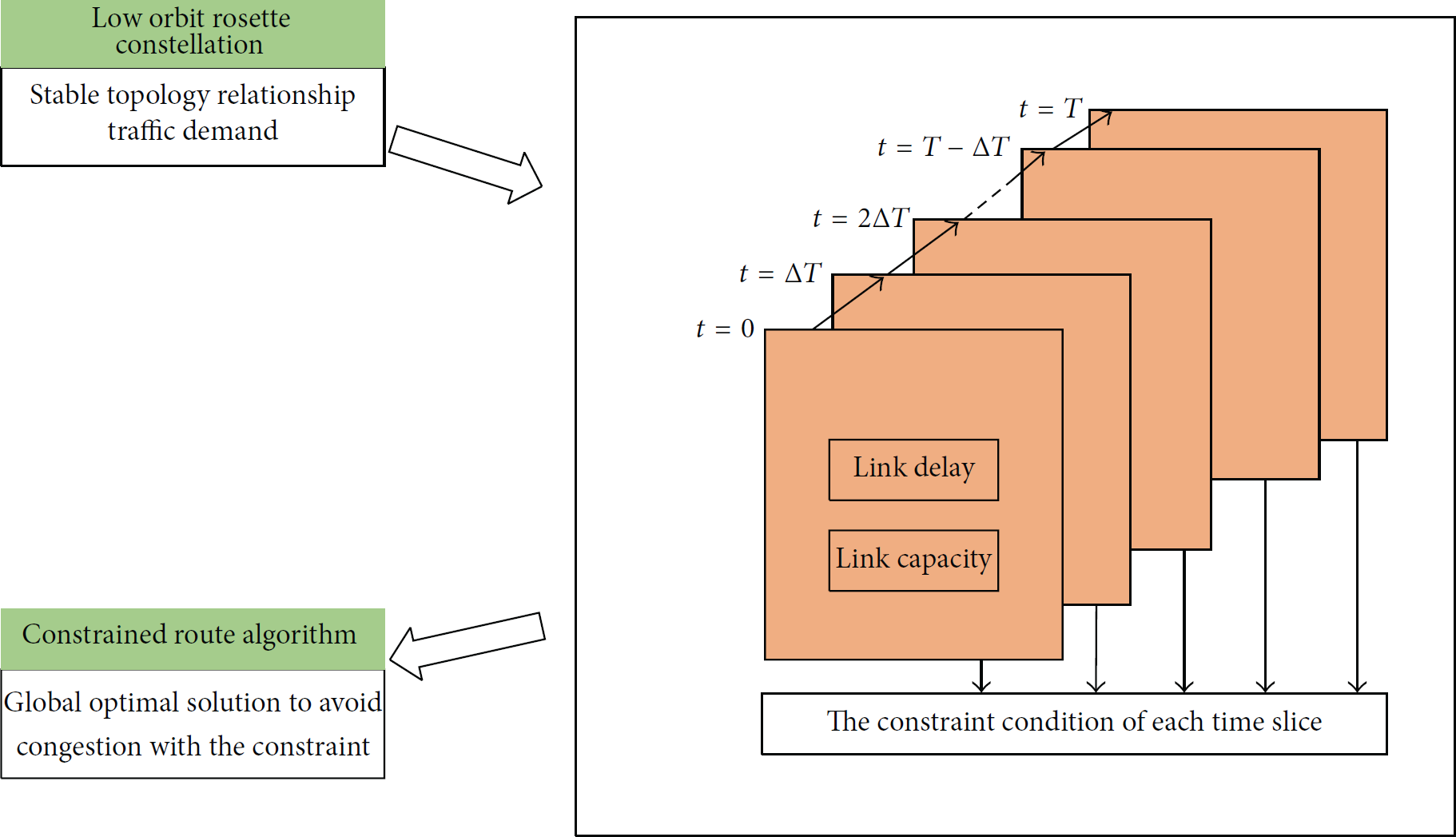
According to the analysis presented above, the LEO rosette constellation sensor network exhibits a stable connection relationship, periodic orbit movement, and time-variable link capacity and delay. On the basis of these characteristics, a method of constrained route based on the metric of time-varying delay and capacity (CR-MDC) is proposed to avoid congestion of satellite sensor network for LEO constellation. In the CR-MDC, the satellite network period is divided into several time slots, and the topology can be considered fixed in each time slot [27]. Routing aims to minimize maximum link utilization to avoid congestion through delay and capacity constraints. In each slot, a route is calculated based on the link state of the current state to satisfy these constraints.
A nonbranched multicommodity flow model [28] is built in to calculate route with the aim of minimizing maximum link utilization. The algorithm we proposed is offline. As for the time and monitored region that can be known in advance, it is possible to schedule the traffic from the beginning. So it is reasonable to use the offline algorithm for route in agriculture monitoring.
4.1. Time Slots
Network topology is not fixed because of satellite movement, thus complicating the route for an extended period of traffic time. We can divide satellite network system period T into M time slices and treat the topology in each slice as invariant based on the observation that the orbit movement, as well as the change in the capacity and delay of the rosette constellation sensor network, is periodic. The intervals of adjacent slots are unchanged and can be denoted as
Routing framework of low orbit satellite constellation sensor network.
As shown in Figure 4, the input of the route method includes two parts:
physical topology: including source and destination node of traffic, the distance, and capacity of each link; traffic demand: including egress node, ingress node, and the corresponding traffic requested.
And the output is the route path calculated which is composed of a series of links through this path for each traffic demand with the constraint of link delay and capacity.
4.2. Notations
Some variables needed are defined as follows:
D: the total amount of traffic in the network: for each M: it stands for the total number of sampling time slices over a period of time. U: the L: X: The state “1” for c: it stands for velocity of light.

4.3. Unbranched Multicommodity Flow Model
The unbranched multicommodity flow model can be formulated as follows:


The objective of Function (2) is to minimize the maximum link utilization. The flow conservation constraint (3) specifies, for each source-destination pair
5. Performance Evaluation
Many methods were proposed to calculate satellite network route. These techniques were usually based on the shortest path route and calculated with the Dijkstra algorithm. For example, Werner proposed the DT-DVTR routing scheme [29] and adopted the Dijkstra shortest path algorithm to compute the optimal path for any pair of satellites. Mohorcic et al. established a centralized routing protocol based on the Dijkstra algorithm [30]. A classic algorithm, the LAOR route scheme [31], utilized the Dijkstra algorithm as a route algorithm to calculate routes with the goal of minimizing end-to-end delay and signaling overhead simultaneously. However, these schemes are not designed or supposed to take enough QoS metrics into account. Moreover, these methods adapt poorly to link congestion. Considering the defects mentioned above and the characteristic of the satellite sensor network established in this study, the proposed algorithm aims at avoiding congestion based on time-variable metric of capacity and delay. To evaluate the proposed method, we conduct relevant comparisons through Dijkstra-based routing. In addition, parameters such as the average blocking probability, average network delay, and maximum link utilization of a network are determined to compare CR-MDC with Dijkstra-based routing.
5.1. Performance Metrics
5.1.1. Blocking Probabilities
Blocking probability represents rejection probability of the connection, which is an important indicator of the degree of network congestion. Assume link capacity


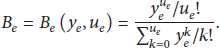
Assume that model of connection requests arrival to each link is a Poisson process. As the traffic is monoclass, the blocking rate of each link is formulated as


5.1.2. Network Delay
The delay of the packets traversing a link e is composed of three parts: queuing delay (

5.1.3. Link Utilization
Link utilization [32] is the ratio of current carried link traffic to the maximum traffic that the link can accommodate, which is often used as one of the important characteristics to evaluate the network congestion. When network utilization exceeds the threshold under normal condition, it will cause low transmission speed, intermittence, request delay, and so on. We derive the link utilization

5.2. Simulation Results of CR-MDC
In this section, we present the simulation results for the proposed CR-MDC. The satellite sensor network of rosette constellation with advantages in global coverage is considered. Ten source-destination pairs shown in Table 1 are randomly selected, and the requested bandwidth between each node pair changes from 1 Mbps to 9 Mbps to evaluate CR-MDC performance. Figure 5 shows that the network blocking probability changes with bandwidth. The blocking rate of Dijkstra-based routing varies with an increase in the requested bandwidth. During simulation, the Intersatellite Link (ISL) capacity of the network changes. The minimum link capacity throughout the entire process is slightly over 7 Mbps, whereas the maximum link capacity is almost 22 Mbps. Dijkstra-based routing is a routing method that considers only the shortest data transmission path regardless of whether the link is congested or not. When the traffic demand is less than 5 Mbps, the blocking rate is almost zero. As traffic continues to increase, the network experiences a severe overcrowding problem which will lead to large amounts of data loss and it is a quite serious problem in agriculture monitoring, whereas in such condition the CR-MDC still keeps the low network blocking probability. The remarkable result for this approach is ascribed to its capability to balance traffic flow. When a link loads considerable flow, the algorithm chooses an alternative link, which also satisfies delay restriction and reaches the destination node. This design facilitates congestion avoidance and balances network flow. The proposed CR-MDC can avoid network congestion effectively because it considers both the delay and link capacity constraints as indicators to determine a reasonable data transfer path; by contrast, the Dijkstra-based routing takes only link delay into account. As a result, the outcome is prone to network congestion.
Ten source-destination pairs.


Average network blocking probability versus traffic requested.
We also simulate the average network delay in comparison with Dijkstra-based routing in different time slots. We retain the 10 paired source-destination nodes shown in Table 1, and the request traffic is 1 Mbps in each pair for each slot. ISL length changes with satellite movement; hence, capacity and propagation delay vary in each slot. As a result, different routes are generated with various algorithms in dissimilar slots in addition to the values of performance metrics. Thirty time slots were simulated, and the results are depicted in Figure 6. As expected, the delay of CR-MDC is higher than that of Dijkstra-based routing. Because the latter considers only the shortest distance this distance exhibits low latency but a high block probability when traffic requests increase. But in large-scale agriculture monitoring, we care more about the mass of data that need to be transmitted reliably to supervision department compared with low delay. Figure 7 presents the mean number of hops per time slot; the number of hops produced by Dijkstra-based routing decreases when a link-cost metric is used that consists of propagation delay computation paths. In addition, the proposed algorithm passes additional hops, in each time slot; thus, the CR-MDC routes traffic through long (in terms of hops) but little-congested paths.

Average network delay versus time slices.

Average hops versus time slices.
Figure 8 illustrates CR-MDC performance in terms of maximum link utilization; as expected, the proposed algorithm outperforms Dijkstra-based routing. The maximum link utilization of the links reaches almost 30% when the network uses the Dijkstra algorithm to calculate the route; by contrast, the maximum link utilization is approximately 13% when the proposed CR-MDC is employed. The higher the maximum link utilization, the higher the probability that the congestion occurs. The Dijkstra-based routing considers only data transmission path regardless of whether the link is congested or not, whereas the CR-MDC could minimize the maximum link utilization which enables it to balance traffic flow. This result indicates that CR-MDC effectively transmits data with the guarantee of congestion avoidance.

The maximum link utilization versus time slices.
5.3. Improvement of CR-MDC
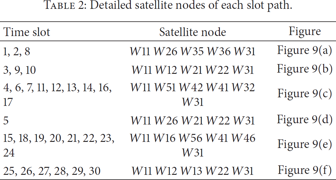
In order to have a thorough study of CR-MDC, we also present the route path in each slot of the ten pairs in Table 2. We take the pair (
Detailed satellite nodes of each slot path.
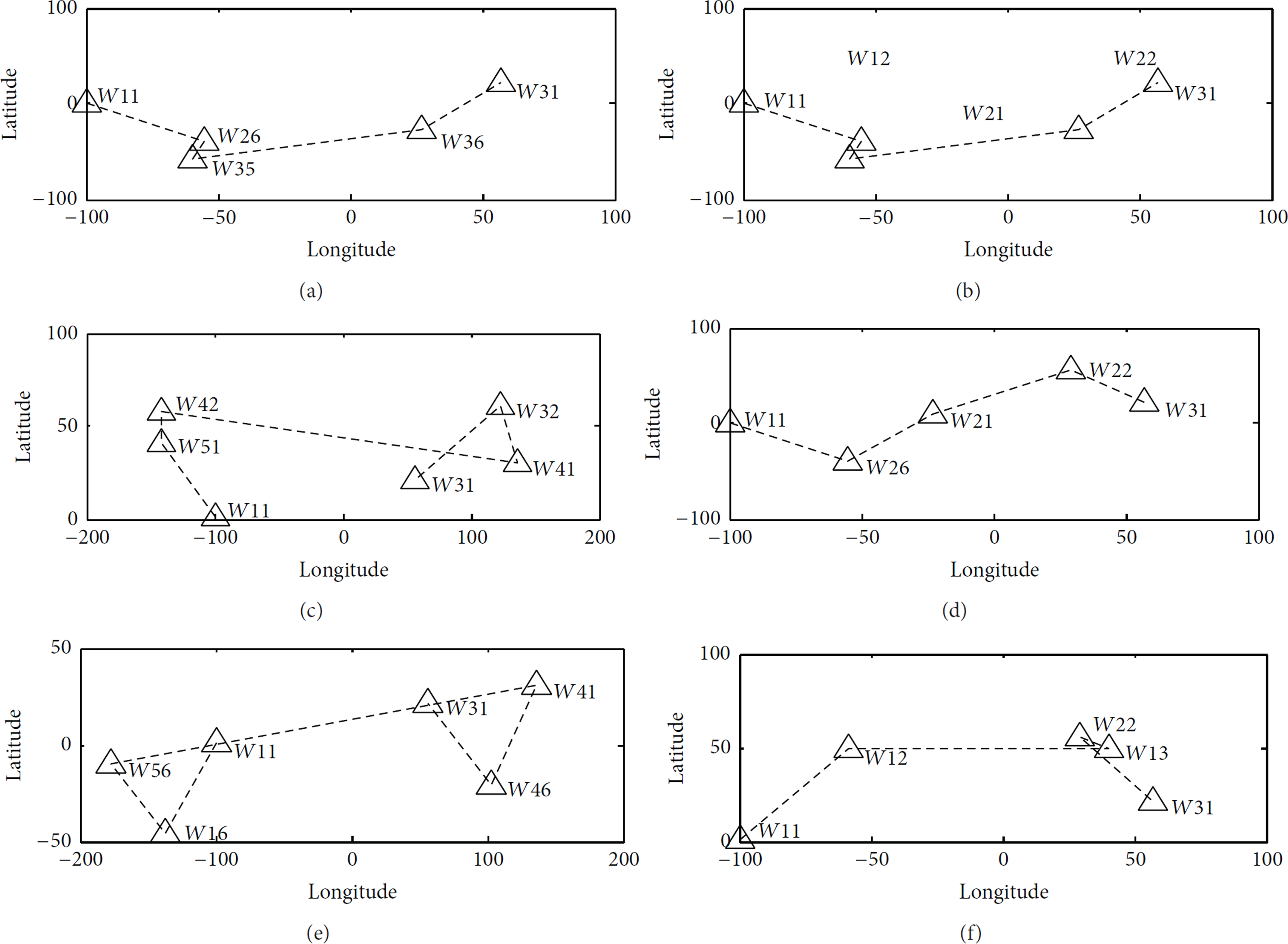
Route of the pair (
Based on that, improvement of CR-MDC can be made to reduce the handoff times by adding another optimization objective of minimizing the route diversity
The improved CR-MDC model can be formulated as follows:


Constraint (15) is the constraint of route similarity, which can be denoted as follows:

Figure 10 depicts route diversity versus time slots. The numerical value in the figure is a ratio expressed as a percentage which can be formulated as


Route diversity versus time slot.
The performance of the method with similarity constraint in terms of maximum link utilization is illustrated in Figure 11. The result shows the method with similarity constraint has a higher link utilization than the method without similarity constraint. As is shown in Figure 11, the maximum value of the CR-MDC is almost 0.137 while the maximum value of the optimized CR-MDC is almost 0.142. And the two methods have the same minimum value that is close to 0.136. And in Figure 12 the maximum link utilization of three routing methods is presented. Just as we expect the Dijkstra has the maximum link utilization, whereas the CR-MDC has the minimum link utilization. Therefore, all these values explain that compared with the CR-MDC the optimized CR-MDC not only has a lower route diversity which is beneficial to reduce switch times, but also greatly influences link utilization which is an essential measure of network congestion.

Maximum link utilization of CR-MDC and improved CR-MDC.

Maximum link utilization of three routing methods.
6. Conclusion
In this study, we have designed a novel constrained route method that models a network through a discrete-time figure to avoid satellite sensor network congestion for agricultural monitoring. We have formulated the problem as a multicommodity model with time-varying parameters, and the simulation results demonstrate that the proposed scheme reports a lower average network blocking probability than other algorithms do. Even as traffic increases, the blocking probability remains low; this outcome confirms that the method influences congestion avoidance by the satellite network when this network is used to transfer much data. And in order to reduce handoff times, an optimized CR-MDC with similarity constraint is presented in this paper which is beneficial to reduce switch times but also has a great result on network congestion.
Footnotes
Conflict of Interests
The authors declare that there is no conflict in interests regarding the publication of this paper.
Acknowledgments
This work was partly supported by the National Natural Science Foundation of China (NSFC) under Grant no. 61371126, the Fundamental Research Funds for the Central Universities under Grant no. 2042014kf0256 and no. 2042014gf020, the National High Technology Research and Development Program of China (863 Program) under Grant no. 2014AA01A707, National Basic Research Program of China (973 Program) under Grant no. 2011CB707106, the Natural Science Foundation of Hubei Province under Grant no. 2011CDA042 and no. 2014CFB716, and Innovation Foundation of Satellite Application Institute of China Aerospace & Technology Corp. (CASC) under Grant no. 2014_CXJJ-TX_15.