
Abstract
With the continuously increasing number of vehicles, particularly in cities, there are more and more abnormal traffic events occurring on road, which easily cause road congestion. In vehicular sensor networks (VSNs), with the intervehicle cooperative communication, vehicle nodes can detect the abnormal traffic events and disseminate the related information to the interesting vehicles or persons. This paper gives out a survey of the abnormal traffic information detection and transmission mechanisms in VSNs. Firstly, we overview the origin, characteristic, and application of VSNs. Meanwhile, the definition and features of traffic abnormal information are also introduced and presented. Then, we put more energy on elaborating the existing information detection and transmission mechanisms based on VSNs. Finally, the challenges and problems are discussed.
1. Introduction
1.1. What Are Vehicular Sensor Networks?
1.1.1. Origins and Definition
Recently, with the rapid development of various information technologies such as computer, communication, and microelectronics, a large amount of systems for different applications need to be gradually emerged. And every new emerging application system is an integrated body with multiple complex technologies.
For instance, under the support of microcomputer and embedded operating systems, the functions of smart onboard devices become richer. They continuously improve the travel quality and driving efficiency from all aspects, so the number of vehicles equipped with smart onboard devices increases greatly. For this reason, as a transport tool, vehicle begins to play a new and important role.
Particularly, after the mobile ad hoc networks (MANETs) have been popularized in field of intelligent transportation system (ITS), the vehicles and roadside access points (APs) can connect with each other and form into a new application system—vehicular ad hoc networks (VANETs) [1]. It enriches the users' driving life, by providing lots of services like traffic information dissemination and inquiry, entertainment resources sharing and downloading, and so on [2]. Comparing with MANETs, the vehicle node is more mobile and the network connectivity is even worse in VANETs. In addition, MANET is based on no infrastructure, but VANET is hybrid network architecture, and the vehicle node could improve the network connectivity using the roadside infrastructure.
Meanwhile, wireless sensor networks (WSNs) [3] are formed in a self-organized manner, by a large number of low-cost and low-power microelectronic sensors with perception, computing, and wireless communication capabilities. In WSNs, all the nodes cooperative senses collect and process data. Their intelligent and pervasive features provide a good way for people accessing the physical world information at any time and any place. However, early WSNs focus on monitoring static objects like wild volcano monitoring, forest monitoring, and so forth. In order to collect the information of moving objects, mobile sensor networks (MSNs) emerge [4]. In MSNs, many initial researches are around the wildlife animal migration monitoring and habits tracking, so they have some limitations [5–7]. But for the current popular pocket switched networks (PSNs) [8] or social networks [9], which are both formed by handhold devices, and the body sensor networks (BSNs) [10, 11], which is formed by multiple body carrying medical sensor nodes, their monitoring objects are moving people. They are other manifestations of MSNs and can be used to prevent diseases and monitor health. These various popular application systems can be seen in Figure 1.

Various popular application systems.
When the moving objects refer to vehicles, the concept of vehicular sensor networks (VSNs) naturally appears [12, 13]. In short, VSN is one typical application of MSNs in field of vehicles, which is composed of smart onboard sensor nodes and road side units (RSUs) [14]. There exists two communication modes: vehicle-to-vehicle (V2V) communication and vehicle-to-RSU (V2R) communication [15, 16], as shown in Figure 2. Additionally, RSUs can be connected by pass-by mobile vehicles [17]. Some more powerful RSUs access Internet by wired cable, optical fiber, or utilizing the wireless base stations (WiMAX, 3G, LTE) operated by service provider. Comparing with VANETs, VSNs can make up the drawbacks for lack of front sensor information input function and enrich the network transmission contents, relying on its unique perceived advantage.
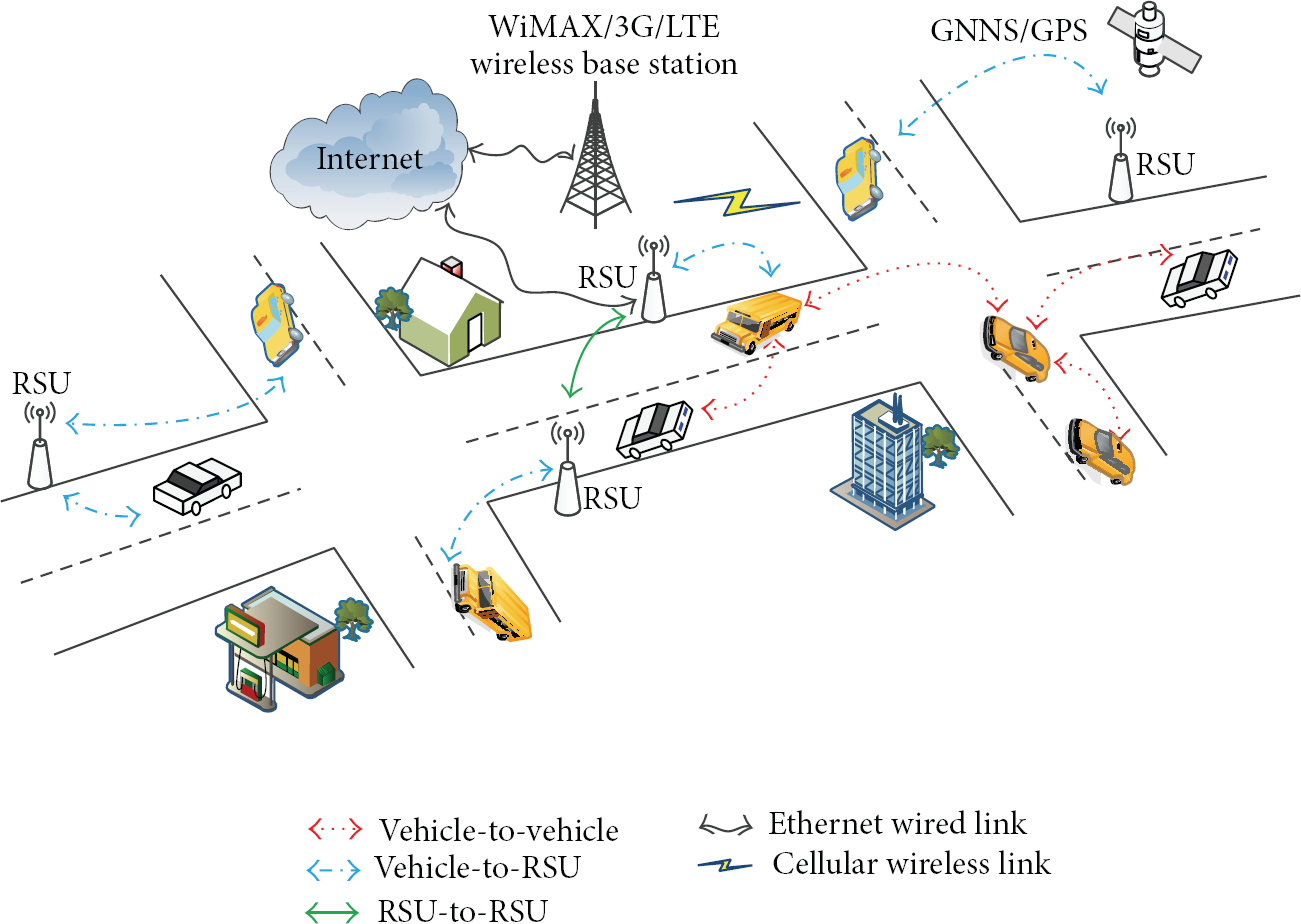
The popular architecture of the vehicular sensor networks.
1.1.2. Main Characteristics
Different from the traditional WSNs, VSN mainly has the following characteristics.
Intermittent Connectivity. Due to the high mobility of vehicle nodes and the interference of wireless communication obstacles like city buildings, trees, and so forth, the network topology of VSNs is highly dynamic and the link duration time is quite short. Thus, the network connectivity is worse. Furthermore, there is no fixed end-to-end path between vehicle nodes.
Predicable Movement. Since vehicles are limited to move on road, constrained by the road topology and the front vehicles, the movements of vehicle nodes are predicable.
Enhanced Transmission and Processing Ability. For the low-cost and low-power WSN nodes, their energy, storage space, transmission range, and processing speed are limited. But VSN nodes have no strict hardware conditions limitation, so their data transmission range and processing performances are enhanced.
Node Selfishness. The number of vehicles moving on city road is large, for some reasons like privacy protection or energy saving need, part of vehicle nodes are unwilling to participate in data forwarding. So, the vehicle nodes in VSNs have selfishness.
Network Openness. Because vehicle nodes are not always “online”, large number of nodes would frequently join or leave the network. When vehicles are parked on the street, some vehicle nodes will be “offline” temporarily; meanwhile, other new vehicle nodes will be “online”. Thus, openness is the basic feature of VSNs.
Unbalanced Network Topology. Influenced by the road topology and traffic condition, for the same road segments at different time or the different road segments at the same time, the distribution of vehicle nodes is uneven and changes greatly. Thus, the network density switches in sparse and dense states frequently. In addition, the regional network partition phenomenon may produce “information island” effect [18] in a time period.
1.1.3. Application and Projects
VSN has extremely important research position and broad application prospects in ITS. After induction and summary, most applications focus on the following aspects.
Ensure the Driving Safety [19]. Vehicle nodes can sense much dangerous information on road, such as surface gathered water, icy pavement, visual obstacles under weather of dense fog, large falling objects on highway, emergency braking, and car breakdown. With the cooperative intervehicle communication technology in VSNs, the above dangerous information can be broadcasted to the vehicles behind to avoid car collision and ensure the driving safety.
Reduce the Driving Time. According to the real-time traffic information gathered from mobile vehicle nodes, the future road conditions can be estimated. Through identifying the traffic abnormal information, vehicle nodes can assist driver to bypass congested roads and optimize the travel routes. Thus, it saves the travel time.
Improve the Driving Services. Recently, more and more drivers begin to concern on diverse driving services, such as travel office, file download, free chatting, and entertainment resources sharing. Specifically, drivers could download desired text files or video slices using RSUs in VSNs. By learning the concept of social network, drivers could chat or search the nearby parking, hotels, discount shopping, and other life information. Also, they can share all kinds of interested entertainment resources like popular music, sports, news, and so forth.
VSN also has great applied value in urban environment monitoring [20], traffic management and scheduling, vehicle tracking [21], carpooling and vehicle calling [22], emergency disaster relief [23], and so on.
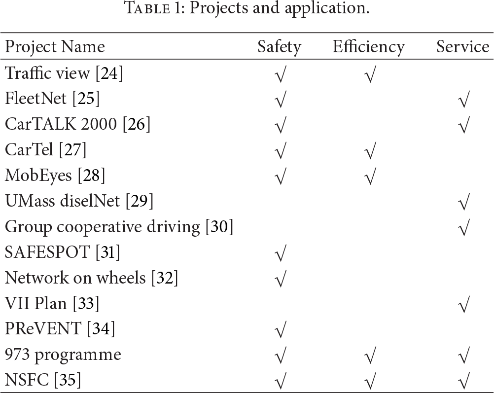
Over the years, the research about VSNs has gained the favor of many academic communities and large well-known companies. And the National Science and Technology Departments provide adequate funding to finance those projects. The typical projects and their applications have been listed in Table 1.
Projects and application.
1.2. What Is Traffic Abnormal Event?
1.2.1. Definition and Characteristics
On city road, some unexpected and sudden accidents often happen, like car collision, car turnover, car breakdown, falling objects, severe weather, large-scale commercial activities, temporary road control, and so forth. They not only affect the normal traffic flows, but also easily result in decreased road capacity. Thus, we name them as traffic abnormal events. In Figure 3, it shows the difference of traffic flows on roads in normal and abnormal states.

The difference of traffic flows on roads in normal and abnormal states.
Based on our observations, the traffic abnormal events on city road mainly have the following characteristics.
Suddenness and Uncertainty. Whatever the event time or the happening place, the occurrence of traffic abnormal event has the features of suddenness and uncertainty.
Danger and Importance. There is a certain danger in traffic abnormal event. Fast and accurate traffic abnormal information is more beneficial to improve the road safety and reduce the economic losses of drivers.
Diversity and Complex Causes. Any complex and changeable, objective and subjective factors will affect the city traffic conditions.
Derivative and Chain Effect. Once the traffic abnormal event happens on city road, secondary accidents and road congestion events are easily derived. And it can be seen that there exists a chain effect between them.
Diffusibility and Persistency. The traffic abnormal event will not disappear immediately; it will persist for a period time. If it is not timely dealt with or disposed of properly, more road segments will be congested along with the event diffusion. The event impact area will expand to farther regions and show different evolution trends.
Expressive and Detectable. The physical variables of traffic abnormal event and secondary road congestion event (such as speed, picture, and direction) can be detected by sensors and expressed as information. In Figure 4, it shows the logical deduction relationship among traffic abnormal event, road congestion event, traffic abnormal information, and road congestion information.

The logical deduction relationship between event and information.
2. Motivation and Background
2.1. Why Study the Traffic Abnormal Information Detection and Transmission Mechanism?
Traffic abnormal event is the main factor reducing the city road capacity and service level. When the event status is light, road congestion problem will arise. When the event status is serious, people's lives and property safety will be threatened. Meanwhile, the first task of constructing Smart City is to detect the traffic congestion points on city road and improve the ability responding to emergency events for roads. Thus, utilizing VSNs technology to achieve interconnection between moving vehicle nodes is very helpful to improve the intelligent degree of city road and alleviate the growing issues of traffic congestion [36, 37].
The traffic abnormal event will bring great changes in traffic flow, which also can be reflected in the mutation of physical parameters. With the onboard nodes in VSNs, the road environment information is sensed and collected. Based on these data, drivers can extract and deduce the traffic abnormal information. For the traffic abnormal information, if it could be transmitted to the event impact area or potential information subscribers, drivers will adjust their travel routes to shy away the road congestion. So, it is necessary and meaningful to study the traffic abnormal information detection and transmission mechanisms based on VSNs.
2.2. Traffic Abnormal Information Detection Based on VSNs
Now, most of the related research work about the traffic abnormal information detection mechanisms is based on VSNs and mainly focuses on the incident detection and road congestion detection.
2.2.1. Incident Detection
Incident detection puts more energy on perceiving and preventing traffic incident event in advance, so as to assist building an in car safety warning and driving system. As for the technology implementation, the e-NOTIFY system [38] uses the on board units (OBUs) to gather and process dangerous information and make final decisions. The NOTICE system [39] firstly embeds sensor belts in the road at regular intervals then detects the abnormal event based on the communication between sensor belts. And each belt consists of a collection of piezoelectric pressure sensors, a simple aggregation and fusion engine, and a few small transceivers. In [40], a novel probabilistic automatic incident detection technique is presented for nondense traffic flow based on Bayesian theory. And it utilizes the communication between RSUs and sensor belts to detect the incidents.
2.2.2. Road Congestion Detection
The traditional road congestion detection mechanisms mainly rely on traffic flows observation and auto congestion identification (ACI) algorithms. To be specific, large-scale infrastructure-based sensors are deployed at cross-roads to gather traffic flow data, such as inductive loop detector [41], video camera, and radio frequency identification receiver. Traffic control centers (TCC) or RSUs play the role of sink nodes and are responsible for detecting congestion information by running ACI algorithms.
In [42], based on the correlation coefficient of stationary coil sensor data collected from different crossroads, random variable matrix and complex network model are created. Through observing the eigenvalue changes of random matrix, the fluctuations of traffic flows on some road segments are detected. Combined with the cluster analysis method, the position and scale of traffic congestion can be obtained. In [43], based on the recorded live video streams or pictures, the proposed MORYNE system evaluates the surrounding traffic information by adopting video graphical analysis (VGA) method. After processing this traffic information, the road congestion information is extracted by TCC.
Other typical information preprocessing techniques also include: congestion identification based on gain amplification [44], congestion identification based on wavelet analysis [45], congestion prediction based on pheromone model [46], and congestion detection based on pattern recognition [47]. Obviously, those centralized TCC-based detecting methods have high detection overhead and long response delay.
In order to gather real time and dynamic traffic flow data, some scholars proposed the distributed congestion detection mechanism based on VSNs. For instance, Bauza et al. raise the cooperative traffic congestion detection (CoTEC) system in [48]. It uses onboard sensors to transmit and receive CAM packets to estimate the surrounding traffic density. By applying six LOS road service levels supported by Skycomp platform and the fuzzy theory, the vehicle nodes can implement the local road congestion detection by the cooperative intervehicle communication technique.
At the same time, the information fusion technique has also been applied into road congestion detection based on VSNs. Generally, it is used to extract the congestion feature information or generate the final result of congestion detection. For instance, the traffic view system utilizes the threshold-based message aggregation method to remove redundancy atomic information and extract the congestion feature information. Due to the fixed threshold values constraints, the number of aggregation message pairs is limited. So, the information fusion efficiency is low.
In [49], the SOTIS system proposes the road segment-based message aggregation method. All the messages with the same road segment ID can be aggregated together. Since the length of road segment is fixed, it is hard to achieve a good tradeoff between the information fusion efficiency and the information detection accuracy. In [50], the Street Smart system proposes the cluster structure-based message aggregation method. It requires that the network topology to be completely connected. Because of the dynamic changeable cluster structures, the information maintenance cost is quite large in VSNs. In [51], Dietzel et al. propose a structureless message aggregation method based on the fuzzy logic algorithm. Although it can reduce the maintenance cost of dynamic structure, the computation overhead is still considerable. In [52], Liu and Chigan design a parallel-style SLMA method based on decision-level information fusion. And each vehicle node has an opportunity to become the decision maker. Therefore, it can avoid the interference of uncertain and inaccurate sensor data.
Additionally, with the help of the audio receiver units mounted on street lamp post [53], the GPS system embedded in drivers' smartphone [54], or the E-SAR airborne radar sensors [55], the road congestion information detection also can be realized.
2.3. Traffic Abnormal Information Transmission Based on VSNs
2.3.1. DSRC-Based One-Hop Transmission
Dedicated short range communication (DSRC) is the dedicated wireless communication technique in vehicular environment. It is based on the IEEE 802.11p standard [56]. Compared with conventional cellular WiMax or GPRS communication, DSRC has the advantages of low cost, high speed, low delay, and high reliability.
DSRC is capable of delivering 27 Mbps data rate by using a two-way line-of-sight radio and provides seven 10 MHz wide channels at the 5.9 GHz licensed band. As shown in Figure 5, channel 178 is the control channel (CCH), which is restricted to safety communication only. Other two channels at the edges of the spectrum are reserved for future advanced accident avoidance applications and high-powered public safety usages. The rest are four service channels (SCHs) and are available for both safety and nonsafety usage [57].
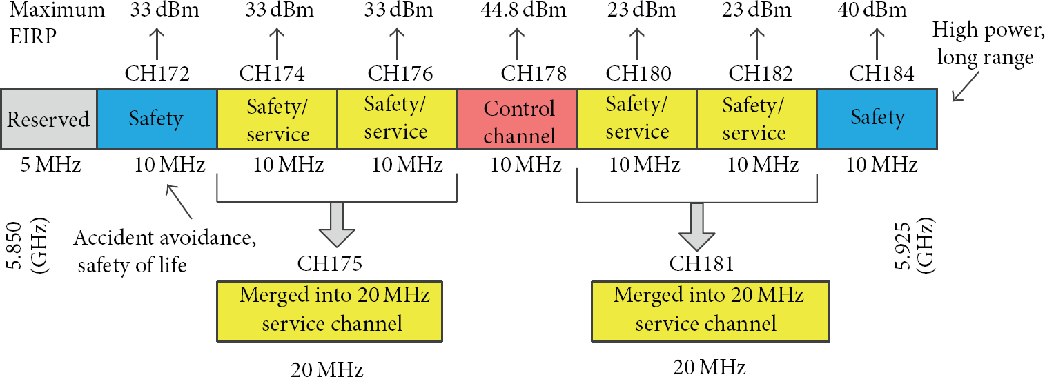
Channel assignment in range of 5.850 GHz–5.925 GHz.
2.3.2. Routing-Based Multihop Transmission
According to the transmission strategy, the existing multihop routing technologies in VSNs can be classified into broadcast, multicast, and unicast. From the perspective of routing information, all the multihop routing protocols can be divided into topology-based routing, location-based routing, DTN-based routing, and hybrid-style routing. The detailed classification results have been shown in Figure 6.

The classification of multihop routing technology in VSNs.
(a) Transmission Strategy
(i) Broadcast. “Broadcast” aims at delivering information to all vehicle nodes. The traditional flooding-based broadcast methods easily cause broadcast storm problems. To address this issue, most broadcast protocols in VSNs focus on reducing message redundancy and optimizing the selection of rebroadcast nodes.
For example, a content-based dissemination protocol for VANETs is proposed in [58], which defines an event-related degree parameter to indicate the encounter probability between vehicle node and event. The last broadcast vehicle node selects the neighbor node that has the highest event-related degree value to be the next rebroadcast node. In this way, the event information can only be transmitted to potential users, so the total number of rebroadcast nodes decreases. In [59], a cross layer broadcast protocol for multihop emergency message dissemination is proposed based on the handshaking mechanism. In order to restrict the total number of rebroadcast nodes in the whole network, it optimizes the selection of next rebroadcast node by comparing some information like distance, speed, channel condition, and so forth. Moreover, the handshaking mechanism can prevent much unnecessary information rebroadcasting operations.
In [60], the authors propose a fast and reliable emergency message dissemination mechanism. It divides the road into multiple small segments of equal areas according to the vehicle density. The minimal waiting time slot is assigned to the vehicle node located in the farthest road segment. This idea is repeatedly used to handle the broadcast storms, but it still may produce the spatial broadcast storm problem [61]. To this, the idea of ring-based road division is first raised in [62], where the width of each ring is computed based on the density of neighbor vehicles. The vehicle nodes in the farthest ring will be assigned the shortest waiting time.
(ii) Multicast. “Multicast” aims at delivering information to multiple vehicle nodes. It includes cluster-based routing and geographic broadcast (geocast) routing. In cluster-based routing, the objects of multicast are all the nodes in each cluster structure. And the formation of cluster structure is based on the vehicle ID, the relative mobility between vehicles, or the composite information of vehicles. For example, the COIN [63] protocol utilizes the mobility, position, and behaviors of vehicle nodes to build the cluster structure.
In geocast routing, the objects of multicast are all nodes in the targeted geographic area, which is also called the zone of relevance (ZOR). To reduce the communication overhead and avoid the network congestion, the zone of forwarding (ZOF) is designed to limit the flooding range. At first, the message is transmitted to the ZOF by the unicast routing. When the message has arrived in ZOR, it will be delivered to all the other vehicle nodes by the flooding method. The most classic geocast routing protocols include IVG [64], cached geocast [65], and abiding geocast [66].
In [67], the Mapcast protocol is proposed based on the mutual positions of nodes and the CSMA/CA MAC mechanisms. It extends the intuitive concepts of Geo-Broadcast towards a more precise idea of Map-Driven forwarding, where the real life road topology leads the forwarding policies.
(iii) Unicast. “Unicast” aims at delivering information to the specified vehicle node. It is widely applied in the data gathering and publish/subscribe systems. Actually, data gathering can be thought of as a special publish/subscribe system initiated by the sink node. For instance, Palazzi et al. exploit the base station (BS) to create request packets and continuously broadcast them in BS coverage area [68]. Then, those vehicle nodes driven into BS coverage area and received request packets will become specified target vehicle nodes. They are responsible for gathering and replying interest information for BS.
In [69], Shafiee et al. propose a request-adaptive packet dissemination mechanism (RPDM). Firstly, it asks the subscribe node to disseminate the request packets until finding the target nodes conforming to the return condition (RC). Then, the reply mechanism is triggered by target nodes. To expand the environment sensing area, RPDM designs more flexible RC structure, which can be adaptive to different RC types and delay conditions.
(b) Routing Information
(i) Topology-Based Routing. Generally, the topology-based routing refers to the traditional MANET routing, which define the data forwarding rules based on the link information stored in routing tables. They mainly include the following.
Proactive Routing. It requires the node to broadcast and exchange the routing information packets periodically, thereby discover the routing initiatively. In addition, each node has to maintain all the nodes' routing information. To reflect the changes of the network topology, the routing tables also need updating frequently. For the high mobile vehicle nodes in VSNs, the proactive routing will spend too much communication cost. The typical proactive routing protocols include: DSDV [70], OLSR [71], and FSR [72]. On-Demand Routing. It contains two procedures: routing discovery and routing maintenance. Moreover, their topology and routing tables are built on demand; that is, only when the source node finds that there exists no path to destination node, the routing discovery procedure will be started. The typical on-demand routing protocols include: AODV [73], DSR [74], and TORA [75]. Hybrid Topology Routing. It aims to minimize the routing control overhead of proactive routing and the routing discovery time of on-demand routing. It splits the whole network into two zones: inside zone and outside zone. Then, each node maintains the inside zone routing by the proactive routing and discovers the outside zone routing by the on-demand routing. The typical hybrid routing protocols include: ZRP [76] and ZHLS [77].
(ii) Location-Based Routing. In location-based routing, each node must be aware of its position information, so it can forward data to the optimal neighbor node that is closest to the destination node. However, the optimal neighbor node does not always exist. To solve this problem, lots of protocols are proposed, such as GPSR [78], GyTAR [79], and RIRP [80]. But, for the reason that they assume that lots of nodes have the communication opportunity and ignore the issue of the network nonconnectivity, they are more suitable to the high density VSNs environment.
(iii) DTN Routing. Due to the high mobility and uneven distribution of vehicles, the network topology is dynamicly changeable and the end-to-end connection is hard to keep in VSNs. Moreover, the low market penetration of DSRC devices leads to more sparse and low network connectivity. To enhance the reliability of information transmission, VSNs widely adopt the DTN (delay tolerant network) routing mechanism. The main idea of DTN routing is store and forward. It can be classified into the following.
Knowledge-Based Routing. It utilizes the knowledge information to forward data, such as the link state, history encounter information, movement pattern, and network topology. The common knowledge-based routing methods include the following.
QoS-Aware Forwarding. Most of the QoS-aware forwarding mechanisms aim to minimize the information transmission delay. Moreover, the constraint objects are two mobile vehicle nodes or two static roadside units. If the constraint objects are vehicle nodes, the whole network can be seen as a connected graph with weights, where the weight of each edge denotes the transmission delay of each link. To guarantee the QoS performance, the node will take the minimum source-to-destination information transmission delay as the optimal object and find the optimal transmission route by algorithms like Dijsktra. The typical example is the MEDR protocol [81]. Additionally, QoSBee [82] utilizes the pheromone, produced by bees looking for food, to assist in finding the optimal route, thereby ensure the transmission delay condition. For the delay minimization between roadside units, the probability that the data bundles in queue head could be released to the roadside vehicles is computed. Since the high probability indicates a low transmission delay, the vehicle node with the lowest transmission delay is in charge of forwarding data. The typical examples are PBRS-BBR [83] and PBRS [84] protocols. Prediction-Aware Forwarding. It mainly utilizes the historical statistics, such as encounter time or frequency, movement trajectory of vehicle nodes, to predict the future encounter probability between the vehicle node and the destination node. The neighbor node with the largest encounter probability will be selected to forward data. While the protocols of PROPHET [85], Spray and Focus [86], EBR [87], PER [88], and CCSDV [89] use the history encounter information to predict the encounter probability, TMA [90] and PTDD [91] use the history movement trajectory to predict. Environment-Aware Forwarding. It originates from the CAR routing [92], which is based on the various environmental information to forward data. For example, the SCAR [93] is based on the history neighbor perception, the MobySpace [94] and VADD [95] are both based on the movement pattern perception, the ORWAR [96] is based on the link time window perception, the RDAR [97] and DRADG [98] are based on the distance perception, the Maxprop [29] and RAPID [99] are based on the buffer space perception, and the TADs [100] is based on the traffic pattern and road layout perception. Non Knowledge-Based Routing. It forwards data without any knowledge. Meanwhile, the forwarding behavior is random and blind. The typical routing protocols include flooding [101], epidemic [102], direct transmission [103], and Spray and Wait [104]. Social Routing. It forwards data with the social relationships or behaviors of drivers. For instance, LABLE [105], BUBBLE [106], and PepleRank [107] are proposed based on the social relationship. And PLBR [108], ESPR [109], CSI [110], and HARP [111] are proposed based on the social behaviors.
(iv) Hybrid-Style Routing. The hybrid-style routing integrates the topology-based routing, location-based routing, and DTN routing. For instance, the GeoDTN+Nav system [112] integrates the navigation information with the DTN routing; the GPSR-DTN system [113] integrates the location information with the DTN routing; and the DARCC system [114] integrates the geographic information with the encounter information.
3. Challenges and Problems
3.1. The Node Selfishness
Due to the enhancement of energy-saving and environmental protection awareness, more and more vehicles are required to minimize the energy consumption. For traditional motor vehicles, minimizing the energy consumption is beneficial to reduce the cities exhaust emissions. For power driven or green energy vehicles, minimizing the energy consumption is beneficial to reduce the energy cost and maximize the mileage.
In VSNs, the vehicle nodes have no strict energy constraints, so many data gathering protocols rarely consider the energy consumption problem. Driven by the interests of maximizing the successful data transfers, the data forwarding operations are easily concentrated on some more “excellent” vehicle nodes. As a result of the overhigh energy consumption, the energy consumption is unfair among all the vehicle nodes.
To save energy, more and more vehicle nodes are unwilling to participate in forwarding data. It can be seen that some vehicle nodes are selfish. And the selfishness of vehicle nodes will lead to low reliability of data transmission.
3.2. Redundant Atomic Message
Road congestion information detection aims at supplementing the abnormal traffic information content. For safety considerations, the car manufacturers like to equip various sensor nodes on vehicles. As a result, a huge number of similar and redundant atomic messages are generated in VSNs. The atomic message can express the morphological information, but cannot reflect the event essence. Thus, the existence of huge atomic messages will waste limited bandwidth resources. Meanwhile, they will obstruct and delay the congestion information detection procedure.
Due to the limit of single-level information fusion method and the existence of uncertain environment data, even if the feature-level information fusion method can reduce the redundancy of atomic messages and improve the information detection efficiency, the accuracy and consistency of congestion information detection cannot be guaranteed. Needless to say, inaccurate road congestion information will break the normal traffic order and severely reduce the travel quality. Therefore, how to realize the rapid and reliable road congestion information detection is the primary problem of the traffic abnormal information dissemination.
3.3. Multiregion Geocasting Demands
Because of the diffusibility and persistency of traffic abnormal event, its event impact area changes as time increases. According to the traffic theory, the event impact area starts from the road segment where the event happens and expands to multiple road segments based on the rule of “parallel to the first, after the upstream”. Thus, the traffic abnormal information needs to be disseminated to multiple geographical regions. However, the traditional geocasting methods only consider the geocasting problem oriented one fixed geographical region.
To solve the multiregion geocasting problem, the traditional geocasting protocols create multiple event messages. Each message is affiliated to one geographical region. Since all the multiple geographical regions take the event source as the center and extend toward the upstream, the tree-based geocasting paths are easily repeated. In addition, previous research on geocast protocols pays little attention for information maintenance cost. In WSNs, the nodes in target region are fixed, so it is unnecessary to consider the information maintenance issue. However, the high mobility of vehicles nodes in VSNs makes the information dissemination objects unstable. Specifically, when some vehicles are moving into the target region, other vehicles are moving out of the target region. With the frequent moving behaviors of vehicles, the communication overhead is large. Furthermore, it will bring about another severe problem that drivers may receive same information or miss event information. Therefore, it is quite significant to guarantee the new vehicle nodes obtaining the event information in a reliable and timely manner while paying lower information maintenance cost.
3.4. Interregional Information Subscription
With the help of RSUs, the traffic abnormal information subscription service in VSNs has been greatly improved. But the scope and number of the RSUs' deployment are limited, and their distribution is also uneven. For example, RSUs are deployed densely on main roads in city, while the distribution of RUSs on suburban roads is sparse, sometimes there is no RSU. Additionally, most RSUs play the role of information relay station; only a part of RSUs have the function of accessing Internet, so not all the RSUs can communication with each other. Furthermore, some high speed wireless communication interfaces (like 3G, LTE etc.) need to pay off additional fees. Meanwhile, the huge information subscription requirements will put a heavier burden on the network infrastructure. To deal with this issue, the researchers try to excavate the information transmission capability of vehicle nodes, thereby provide a traffic abnormal information subscription mechanism based on the V2V communication.
Different from the commercial advertising and entertainment information, the traffic abnormal information subscription claims a high probability of successful information transmission. However, the large geographical space between the subscription node and the target node shows an interregional characteristic. And the uneven distribution of vehicle nodes leads to worse network connectivity. Therefore, it has presented a big challenge to interregional information transmission based on the V2V communication in VSNs.
4. Conclusion
In this paper, we first explain the formation of VSNs and describe its network characteristics, applications, and some related research projects. Then, the definition and the main features of the traffic abnormal information are introduced. Following that, we provide the main reasons of studying the traffic abnormal information detection and transmission mechanisms in VSNs. Simultaneously, the current abnormal information detection mechanisms are depicted in detail, respectively. According to the transmission hops, we divide the existing information transmission mechanisms into one-hop DSRC-based transmission and multihop routing-based transmission. In particular, the multihop routing-based transmission mechanisms are summarized and discussed from the view of information transmission strategies and routing information. Finally, the challenges and problems in future are presented. And they can be seen as the valuable reference for future research directions and issues.
Footnotes
Conflict of Interests
The authors declare that there is no conflict of interests regarding the publication of this paper.
Acknowledgments
The authors gratefully acknowledge the support of the National Natural Science Foundation of China (NSFC) (61272504, 61201204, and 61100217), the support of Beijing Natural Science Foundation (4122057), the support of the National S&T Major Program (2012ZX03005003), the support by Research Fund for the Doctoral Program of Higher Education of China under Grant no. 20130009110010, and the Fundamental Research Funds for the Central Universities (2014JBM006).