
Abstract
Traffic incidents, caused by various factors, may lead to heavy traffic delay and be harmful to traffic capacity of downstream sections. Traffic incident management (TIM) systems have been developed widely to respond to traffic incidents intelligently and reduce the losses. Traffic incident response plans, as an important component of TIM, can effectively guide responders as to what and how to do in traffic incidents. In the paper, a real-time automated traffic incident response plan management system was developed, which could generate and manage traffic incident response plans timely and automatically. A web application structure and a physical structure were designed to implement and show these functions. A standard framework of data storage was also developed to save information about traffic incidents and generated response plans. Furthermore, a conformation survey and case-based reasoning (CBR) were introduced to identify traffic incident and generate traffic incident response plans automatically, respectively. Twenty-three traffic crash-related incidents were selected and three indicators were used to measure the system performance. Results showed that 20 of 23 cases could be retrieved effectively and accurately. The system is practicable to generate traffic incident response plans and has been implemented in China.
1. Introduction
Traffic incident management (TIM), as an important component of intelligent transportation system (ITS), is defined as the coordinated, preplanned, and/or real-time use of human resources and equipment to reduce the durations and impacts of traffic incidents [1, 2]. To meet the goals, TIM involves a systematic approach for reducing the amount of time of detecting and verifying traffic incidents, generating appropriate incident response, disseminating motorist information, clearing incidents, and managing incoming traffic until capacity is restored [3]. In practice, TIM plays a vital role in alleviating traffic congestion, saving losses, and increasing safety. Maryland's DOT Coordinated Highways Action Response Team (CHART) reduced the average incident duration by 23% and saved $578 million with travel delay reductions alone in 2005 [4]. Another TIM, Florida's Road Ranger Program, saved 1.7 million gallons of fuel valued at $3.4 million monthly [5]. For San Antonio TransGuide System, a before-and-after study showed a 35% decrease in crashes [6].
To implement the TIM programs, much artificial work was made in incident detection, identification, and response. With the development of ITSs, more automated approaches were introduced into TIM programs. Specifically for incident detection, information dissemination, and incident response, many researches obtained useful achievements. Ma et al. introduced four approaches, reporting hotlines, traffic cameras, traffic sensors, and freeway service patrols, into incident management system and found that the four-integrated approach outperformed the application of four approaches alone to detect incidents [7]. Variable message signs, 5-1-1 system, and Highway advisory radio were also incorporated into TIM to control traffic and transfer information [8]. Some classic or advanced models, such as linear programming and graph theory, were used with advanced data collection and processing to respond to traffic incidents by Zografos et al. [9], Fabiano et al. [10], Chiu and Zheng [11], and Huang and Pan [12]. Case-based reasoning and rule-based reasoning were also introduced in expert system to automatically generate incident response programs and save response time and traffic delays [13, 14].
Many expert systems and decision-making support systems were also developed [15]. There are three main types of the systems: (a) San Antonio TransGuide System is a representative American system, which incorporates magnetic windings, digital traffic sensor, closed circuit television, dynamic information dissemination, and lane control system. The system gains many economic and social benefits, such as decreasing traffic crashes, saving incident-related traffic delays, and reducing fuel consumption and automotive emissions [6]. (b) In Japan, two systems, Help system for Emergency Life-saving and Public safety (HELP) and Fast Emergency Vehicle Preemption System (FAST), are used to manage traffic incidents. With HELP, traffic management center can receive incidents information via mobile phone network and position vehicles using GPS. And with FAST, traffic management center can save much response time through providing emergency vehicles optimal route and priority at intersection. The two systems guarantee traffic safety and smooth traffic effectively [16, 17]. (c) To minimize the incident-related losses, western Europeans are likely to strengthen the management of existing transportation. Perfect traffic facilities and advanced communication and surveillance systems are implemented in their highway networks, such as variable message sign, emergency telephone, and traffic and meteorological sensor. With real-time information provided by these devices, traffic management center can detect and verify traffic incidents timely, predict traffic congestion, and then disseminate the incident and congestion information via variable message sign or highway radios.
Developing advanced traffic facilities and traffic incident management systems has been an important approach to reduce incident-related losses in developed countries. Some components of TIM, that is, traffic incident detection and identification, information dissemination, traffic control, and incident response, have been paid much attention and great achievements have been obtained. However, in developing countries, like China, limited resources are used in building transportation network and managing existing highways is always neglected. Furthermore, for the existing TIM systems, traffic incident response plan, an important component of incident response, is usually a preprepared artificial document to guide decision-making rapidly, accurately, and orderly during incident response. Considering the high uncertainty of traffic incident, response plans and decisions should be adapted to the dynamic conditions. An automated real-time traffic incident response plan, according to the special traffic incident, will be much more efficient and accurate to respond to incidents than the previous work.
The paper mainly focused on a traffic incident response plan management system, an important component of TIM, which could respond to traffic incidents and generate appropriate plans timely and automatically. A web structure of the system was designed for regional highway network in China. A standard framework was designed to save data about event information and used incident response plans. Some crucial modules, traffic incidents identification and plan generation, were also developed. With the system, the highway administrations can make traffic incident response plans more appropriately and effectively. The response plan will also consider each traffic incident's specificity and guides the management of incidents efficiently and specifically, which can save much response time, decrease traffic delay, and save many losses.
2. Proposed Architecture Framework
2.1. System Organization and Web Application
The real-time automated traffic incident response plan management system is designed to generate a special response plan for each incident timely after the incident occurrence and coordinate with many decentralized agencies. There are two main functions for the system: (1) identifying traffic incident after detecting it; (2) generating and managing response plans. To implement the two main functions, it entails the creation of a platform supporting multiple accesses from different users. Such requirements can best be fulfilled by the use of web applications. In the paper, a general framework of system organization and web application was developed, which was divided into three levels (user level, management level, and policy level) and two macroareas (web client and web server), as shown in Figure 1.

Framework of system organization and web application. Policy level: the response plan template, published by national related agencies, is established to guide the generation of regional response plans. The rules identifying regional emergency managers' duties and their actions are also determined. The template and rules can also be adjusted based on feedback from users. Management level: the system's crucial functions are identified. Verifying traffic incident is a crucial procedure to generate traffic incident response plans after detecting traffic incidents. And, also, developing response plans database and managing it play an important role in the system. User level: the range of the system application is identified. Three categories of users are designed, including emergency manager, response agencies, and generic user. And available functions for each category of users are also determined.
The two macroareas, web server and web client, are both necessary to create a full system including the user level and management level. The web client is represented by three categories of users, each with different roles and functions: (1) for emergency manager, their authorities are limited to detect and verify traffic incident, which can trigger the generation of traffic incident response plan and manage response plans; (2) for generic users, like drivers and highway patrols, their authority is limited to helping in detecting traffic incidents; and (3) for response agencies, their authority is mainly to make appropriate decisions and take actions timely to respond to traffic incidents according to response plans. The web server is characterized by a modular structure classified into three subareas: traffic incident detection, traffic incident verification, and response plan.
2.2. Physical Structure
Framework of system organization and web application only show us a conceptual system. Whether the framework can be realized, a physical structure should also be developed, as shown in Figure 2. In our physical structure, emergency management center is a core component. Three other subsystems are connected with emergency management center.
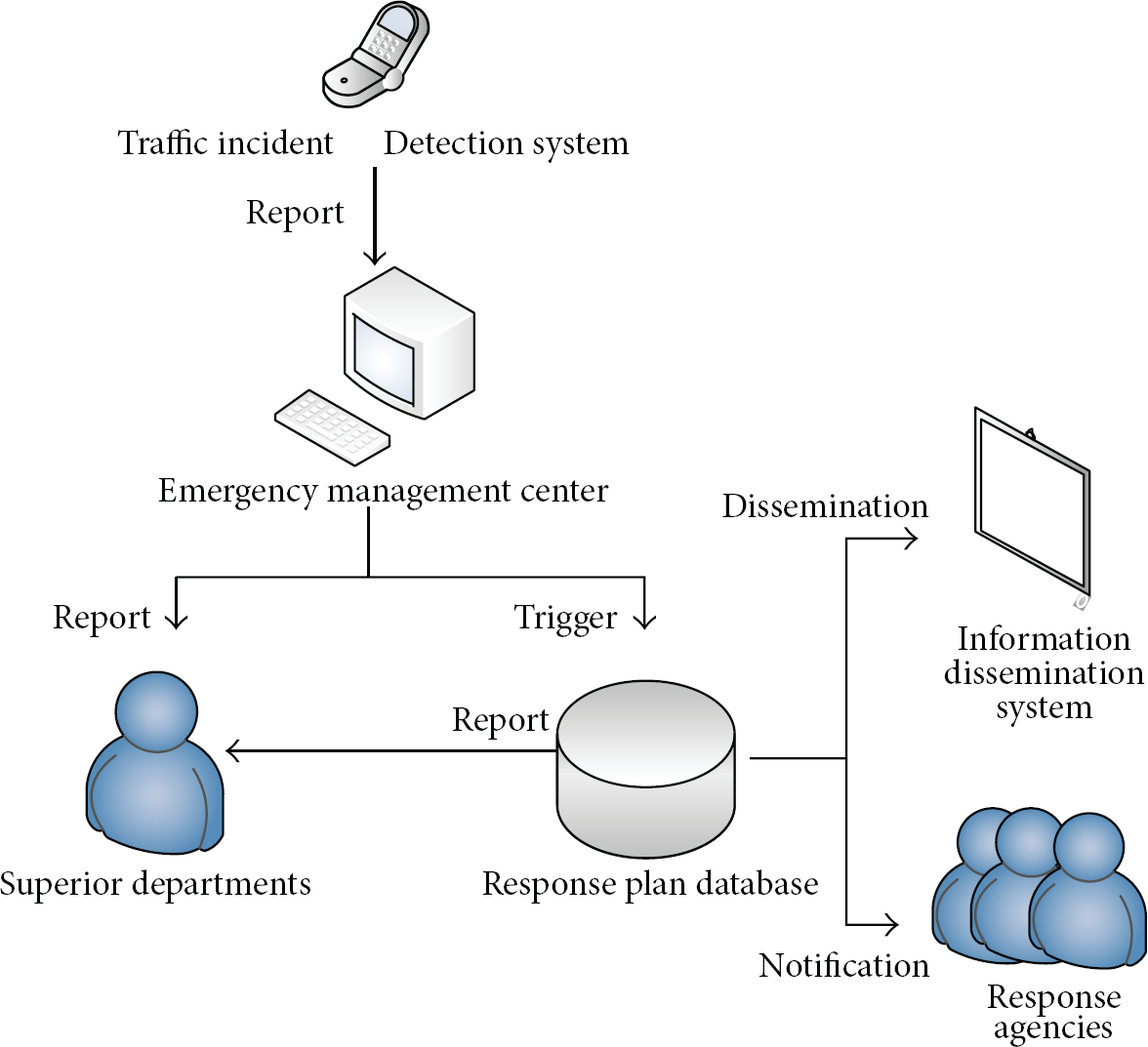
Physical structure of the system.
Traffic incident detection system: identifying traffic incidents and then providing appropriate response plans are all based on traffic incidents detection. Nowadays, many studies have been developed and showed that many instruments can be used to automatically or artificially detect traffic incidents. In the paper, mobile phones, traffic sensors, traffic cameras, highway patrols, and hotlines are recommended.
Superior departments or national traffic incident management system: our regional traffic incident response plan management system should be connected with superior system or national systems. Once traffic incidents are verified and their corresponding response plans are determined, the incidents and their response plans should be reported to superior related departments or national related departments. Through the relationship, the region can also coordinate with other regions to manage traffic incidents much more efficiently.
Response plan database: a perfect response plan database can effectively guide the generation of response plans. After verifying traffic incidents, emergency management center can trigger response plan database to generate corresponding plans. Information dissemination system and response agencies are connected with the database. Once response plans are generated, these plans will be transmitted to all response agencies via Internet. And also, according to response plans, some incident information will also be disseminated to the public through Internet, radios, and variable message signs.
3. Crucial Modules
3.1. Traffic Incident Identification
After detecting traffic incidents, some raw information can be obtained from traffic incident detection system. With the help of traffic surveillance or highway patrols, traffic incident identification can be accomplished. For generating response plans, the identified raw information should be submitted to emergency management center standardly and then trigger response plan database automatically. Thus, a standard survey should be designed to summarize the raw information, which is helpful to share information among different users.
Different factors can lead to various traffic incidents, such as disabled vehicles and traffic crashes. Thus, much information should be confirmed, including basic information and representation information. Name of incident-related highway, time, and weather belong to basic information. Traffic incident categories and their corresponding indicators belong to representation information. To record traffic incidents fully and accurately, a survey is developed based on specifications in China [18], as shown in the conformation survey. The survey is divided into three parts: basic information collection, first-level incident information conformation, and second-level incident information conformation. The first-level incident information is developed to classify traffic incidents into three categories, including traffic crash, disabled vehicles, and abnormal highway conditions. The incident second-level information is designed to confirm traffic impacts and some representation information.
3.2. Plan Generation Based on Case-Based Reasoning (CBR)
How to automatically generate traffic incident response plans based on plan database is the foremost problem for developing the system. Comparing some related algorithms, CBR is adopted, which is the process of solving new problems based on similar experiences within the same domain. CBR is a general paradigm for problem solving based on the recall and reuse of specific experiences. And it is an approach to incremental, sustained learning, since a new experience is retained each time when a problem has been solved [19]. Four procedures are contained in the method, that is, case representation, case retrieval, case revision, and case learning.
3.2.1. Case Representation
Case representation means to represent the cases in the form through which the computer can access, read and store the cases. With the development of the CBR, various case representation methods have been developed, including frame representation and object-oriented representation. Herein, frame representation was chosen considering data processing and system structures. The main frame is the case of traffic incidents, as shown in Table 1 (traffic crashes as an example). And the response plan of traffic incident was stored as the subframe, as shown in Table 2.
Frame of the cases.

Subframe of the cases.
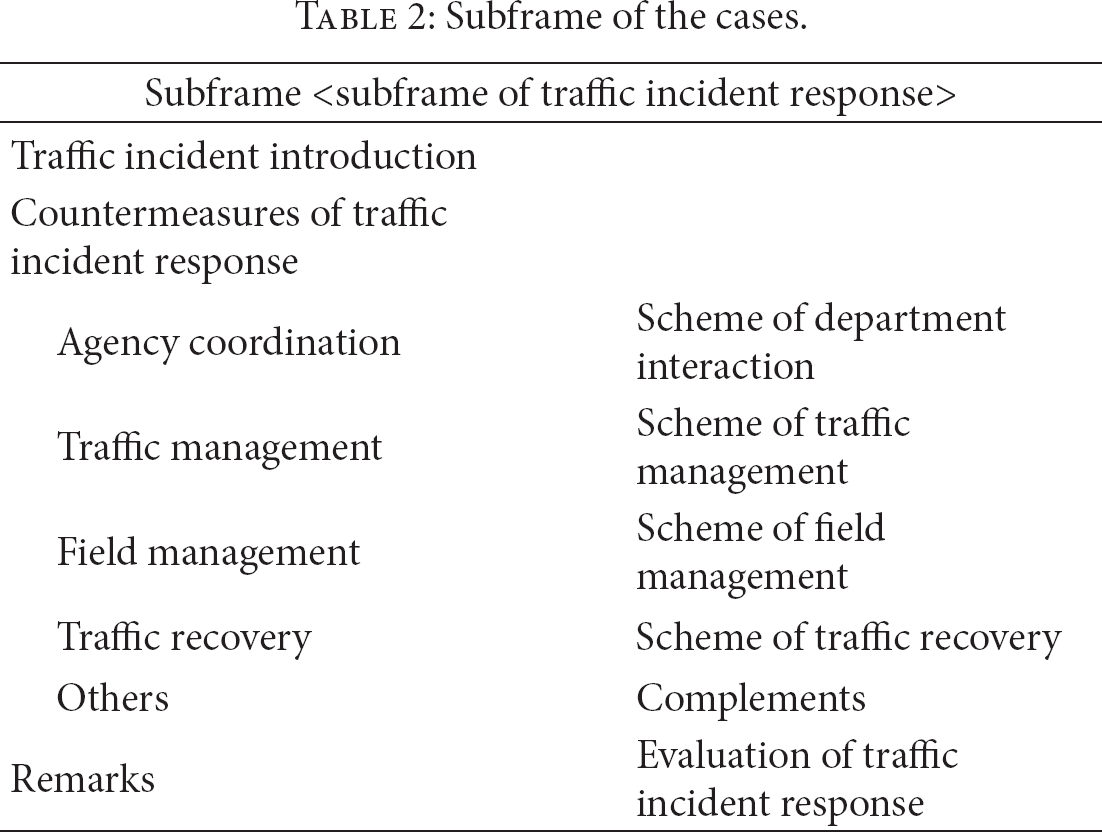
The main frame contains information obtained from the conformation survey. The subframe consists of three slots: traffic incident introduction, countermeasures of traffic incident response, and evaluation of traffic incident response. Five facets were designed for the second slot, including agency coordination, traffic management, field management, traffic recovery, and others.
3.2.2. Case Retrieval
Case retrieval is a crucial procedure of CBR, whose goal is to get a most suitable case from database through computing similarity between incident in progress and saved incidents. Therefore, the system performance is influenced largely by the accuracy of case retrieval. In the paper, k-nearest neighbor approach was adopted to retrieve similar cases. Firstly, the distance for each attribute between current case and cases in database is calculated, which can obtain the similarity for each attribute as shown in (1) [20]. Considering the different importance of attributes, the weighted sum of similarities is calculated by (2) [21]. Weights for each attribute are obtained using expert scoring method, as shown in Table 3. Finally, the cases whose similarities are equal to or greater than the threshold (α) will be retrieved. The larger the similarity of retrieved case is, the much more likely the response plan can be adopted and reused. Consider
Weights of attributes of the cases.


where X is the current case obtained from traffic incident; Y is the case in database; Xi is the value of ith attribute of case X; Yi is the value of ith attribute of case Y; Dist is the distance of each attribute; Sim is the similarity of the two different cases or attributes; wi is the weight of ith attribute; and i is the sequence of attribute.
3.2.3. Case Revision
Case revision is an important challenge of CBR. Every incident has its special attributes. The most similar case may be not appropriate for all incidents. If the managers are satisfied with the retrieved case, it can be reused directly. Or the retrieved case can be revised and improved to cope with its specific condition. Four methods can be used to revise case, including substitution, transformation, special-purpose adaption and repair, and derivational replay. Herein, substitution is adopted and developing new case only changes some related values in old case.
3.2.4. Case Learning
The CBR can learn new knowledge easily, which is a significant advantage. However, if the database for cases is too large, the efficiency and accuracy of case retrieval could be decreased. It is necessary to manage database, such as adding, revising, and deleting cases. If there is no suitable case retrieved, the new case should be added into database after traffic incident by managers. The managers can also revise the retrieved case if necessary. Finally, the managers should delete the useless cases regularly to ensure the efficiency and accuracy.
4. System Implementation and Performances
4.1. System Implementation
Using ArcGIS Server, a visual web system was developed based on browser/server framework and Java to manage traffic incident response plans. Three main functions were obtained, including (1) traffic incident verification: the user-machine interface provides the function for inputting of basic traffic incident information, the class information, and the representation information. (2) Database development: Oracle was adopted to develop database for cases. (3) Traffic incident response plan generation: case-based reasoning (CBR) was introduced to generate traffic incident response plans automatically. Furthermore, the interface was designed, through which various agencies can communicate with each other, such as traffic incident detection system, superior departments, information dissemination system, and response agencies.
4.2. System Performances
To measure the system performance, 23 traffic incidents caused by traffic crashes were selected randomly from traffic incident database operated by Traffic Management Bureau, the Ministry of Public Security of China. For these 23 cases (case 1∼case 23), one case was designed as the current case, and the other 22 cases were developed as the saved database. Each of these 23 cases could be designed as the current case for only once. Thus, 23 case retrievals were available to measure system performance, as shown in Table 4. In the paper, the threshold α was 0.8, which means the similarities of all retrieved cases should be equal to or greater than 0.8. The retrieved case, whose similarity was maximal, has the priority to be adopted and reused.
Results of case retrieval test.
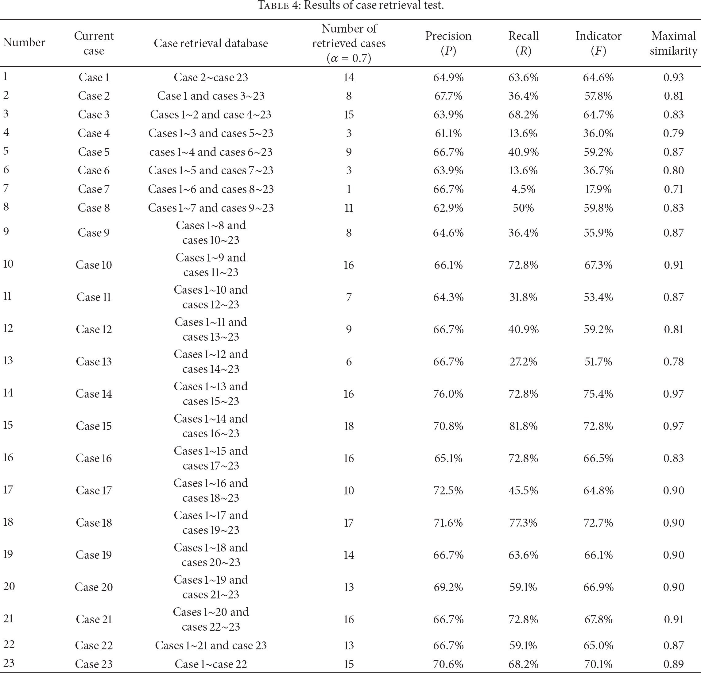
Meanwhile, three indicators were introduced to measure system performance, such as precision P, recall R, and indicator F [22]. The values of these indicators could be obtained from (3). After the case retrieval test, results were shown in Table 4. It was shown that most of current cases could be retrieved effectively using the system, except case 4, case 6, and case 7. The 22 cases in tested database were insufficient to retrieve all current cases effectively and accurately. Through determining the appropriate amount of cases in database, the system might obtain a better system performance. And, also, the retrieval times were all less than 1.0 second, which met the requirement of real-time response. Consider

where n is the number of retrieved cases; Ni is the number of the ith retrieved case's attributes whose value is equal to that of the current case; N0 is the number of attributes for each case; nA is the number of all cases in database; and β is the significance coefficient between precision and recall, herein 0.5 used, which means precision's significance is twice greater than recall's.
5. Conclusion
Traffic incident response plans, as an important component of TIM, are developed to guide decision-making during and after traffic incident. Considering various traffic incidents, a special response plan for each traffic incident will be effective and in time. A dynamic management system of traffic incident response plans can meet the requirement. Considering static management of response plans in China, the paper developed a real-time automated traffic incident response management system. A web application framework and a physical structure of the system were designed. To implement the designed functions, a confirmation survey and case-based reasoning were introduced to identify traffic incident information and generate traffic incident response plan automatically, respectively. With the system, it is much easier and more convenient to develop and manage traffic incident response plans. Using CBR to generate plans makes the system more intelligent and effective. All these are significant for enhancing our prevention and response of traffic incidents. Finally, the system can be incorporated into TIM and make it much more scientific and intelligent.
As a future work, CBR should be debated more completely. Except for case retrieval, two other problems should be solved to enhance the system performance, including appropriate number of cases in database and case management. To determine the number of cases in database, the database should be tested many times. It is time-consuming and energy-consuming. Furthermore, some algorithms for case revision and case learning should be introduced to enhance the efficiency of system, which are helpful to maintain database and automatically generate appropriate traffic incident response plans.
Survey
Conformation of Traffic Incidents in Regional Highway Network
Basic information
Location— — —
Highway stake— — —
Highway grades
□ Freeway
□ Others
Signature— — —
Weather
□ Fine
□ Cloud
□ Rain
□ Snow
□ Fog
□ Frozen
Time— — —
Number of Lanes— — —(one way)
Incident first-level information
Traffic crashes
① Are there casualties or losses?
□ Yes
□ No
② Are there leakages of hazardous chemicals?
□ Yes
□ No
Disabled vehicles
③ Are there disabled vehicles?
□ Yes
□ No
Abnormal highway conditions
④ Are there dropped goods or accidental traffic jam?
□ Yes
□ No
⑤ Are there geological disasters or bad weather?
□ Yes
□ No
⑥ Are there mass incidents?
□ Yes
□ No
Incident second-level information
Traffic crashes
Number of casualties
Minor wounds— — —
Serious injuries— — —
Fatalities— — —
Stranded persons— — —
Main serious injuries (multichoice)
□ Severe trauma
□ Open fractures
□ Coma
□ Severe burns
□ Hurt by hazardous chemicals
□ Others
Fire emergency
□ None
□ Slight
□ Severe or explosion
Turn-over Emergency
□ None
□ Compact car
□ Large car
Hazardous chemicals emergency
License number of vehicle— — —
Name of hazardous chemical— — —
Chemical property (multichoice)
□ Flammable or explosive
□ Poisonous
□ Corrosive
Physical form
□ Gas
□ Liquid
□ Solid
Ranges (multichoice)
□ Lanes
□ Downwind
□ Downstream of rivers
Quantity of leakage
□ Few
□ Mass
Losses of facilities
Number of vehicles— — —
Damaged facilities
□ Guardrails
□ Medians
□ Pavement
□ Traffic signs or markings
□ Others— — —
□ None
Disabled vehicles
Number of disabled vehicles— — —
Abnormal highway conditions
□ Dropped goods
□ Accidental traffic jam
Estimated duration
□ Less than 1 hour
□ 1 to 2 hours
□ 2 to 4 hours
□ More than 4 hours
□ Geological disasters
Types
□ Surface collapse
□ Landslide
□ Debris flow
□ Earthquake
□ Fog
□ Sandstorms
□ Rainstorm
Visibility (meters)
□ 100–200
□ 50–100
□ 30–50
□ Less than 30
□ Snow or ice
Extent
□ None
□ Snow without ice
□ Part of section frozen
□ All section frozen
□ Gale
Cross wind force (level)
□ 6
□ 7–8
□ 9–10
□ More than 10
□ Mass incidents
Traffic impact
Occupied lanes
Direction
□ Single
□ Both ways
Number of occupied lanes— — —
Traffic flow
□ Normal
□ Slow down
□ Congestion □ Stopped
Conflict of Interests
The authors declare that there is no conflict of interests regarding the publication of this paper.
Footnotes
Acknowledgments
This study is funded by National Natural Science Foundation (nos. 51208100 and 51208232). The authors also would like to thank the graduate research assistants from the School of Transportation, Southeast University, for their assistance in data processing.