
Abstract
The position of RFID-tagged objects in sensor networks is becoming an important feature for ubiquitous computing applications. In this work, we develop an improved positioning algorithm for RFID-tagged objects. Compared with the VIRE algorithm, we apply a nonlinear interpolation method to further improve the positioning precision. We also introduce the concept of credibility of reference tags to reduce the influence of abnormal tags on positioning precision. Finally, we provide detailed simulations to evaluate the proposed technique.
1. Introduction
Location sensing is a crucial prerequisite for many wireless sensor networks (WSNs) applications [1] such as asset tracking, industrial automation, and homecare and healthcare systems. GPS is the most widely used technology for localization. However, once arriving at the earth surface, GPS signals are too weak to penetrate the building. To overcome those limitations, various localization technologies have been proposed for WSNs among which are indoor GPS, motion and rotation sensors, infrared, ultrasound, ultra-wideband (UWB), wireless local area network (WLAN), and radio frequency identification (RFID). Due to its lower cost and its technical capabilities, RFID has been widely adopted as an attractive technology for many WSNs' applications, which uses wireless communication for automatic identification of objects.
In the indoor environment, layout structure and moving objects can cause reflection, refraction, diffraction, dead spots, and absorption of radio signals. Therefore, the multipath phenomenon will occur and affect the accuracy of indoor location. Moreover, many other factors also influence the RSSI, such as temperature, orientation of antenna, and height to the ground. LANDMARC [2] was the first attempt using active RFID for indoor location sensing, while VIRE [3] improved it by introducing the concepts of virtual reference tags and proximity map. In this work, we develop an improved positioning algorithm for RFID-tagged objects, which not only achieves robustness to abnormal tags but also dramatically improves the positioning precision.
The rest of the paper is organized as follows. The next section presents a brief review on the related work. Our new approach, NICoT (RFID localization algorithm based on nonlinear interpolation and credibility of tags), is detailed in Section 3. We respectively evaluate the performance of our scheme by simulations in Section 4. Finally, we conclude this paper in Section 5.
2. Related Work
RFID-based ILS solutions can be categorized into the following three areas based on their
localization methods: triangulation-based solutions, proximity, map-based solutions, and scene
analysis solutions. Triangulation [4, 5]: the distance between the reader and tag is calculated by using the
collected signal strength, and the distances are used for triangulation to obtain the position of
the tracking tag. The triangulation method depends largely on an accurate signal propagation model,
which greatly decreases its effectiveness. Scene analysis [6–10]: the scene analysis method captures the signal strength in the
sensing area and compares it with a preexisting signal strength database to map the target to its
location. The scene analysis method needs to build a radio map by calibrating signal strength values
at training locations, which is used repeatedly afterwards. However, the signal strength values
change with the change of the environment. The fingerprint has to be updated periodically, which
requires considerable time and labor. Proximity [6, 11, 12]: the proximity
method needs to measure the nearness of a set of neighboring reference tags. Those tags are close to
the target, and their locations are fixed and known. The measured nearness, along with the
corresponding known locations, is used to estimate the location of a target. The proximity map is a
promising method for complex and dynamic built environments. This method can accommodate the impacts
of the complexity and dynamic nature of built environments. It does not use the RSSI value to
estimate the travel distance of the signal. Instead, it uses RSSI value to compare the nearness of
reference tags to the target, which is qualitative and less sensitive to the obstructions that
impact the propagation of the signal.
In LANDMARC, the concept of reference tags is introduced, which can provide reference locations. The known locations of the nearest neighboring reference tags and nearness to the tracking tag are used in computing the tracking tag's location. The algorithm has the following advantages. First, the algorithm uses tags instead of more readers, which greatly reduces the cost of system. Second, the reference tags and target tags are in the same environment, and the effect of environmental factors can be effectively off-settled. However, the algorithm has the following drawbacks. First, it does not work well in a closed area with severe radio signal multipath effects. Second, to further improve the localization accuracy, more reference tags are needed, which is costly and may cause RF interference phenomenon. In VIRE, the virtual reference tags were used to achieve a higher accuracy. These tags are virtually distributed linearly between real reference tags, which increase the density of the reference tag grids. Locations of the virtual reference tags are known and recorded, and their signal strength is estimated by linear interpolation of that of the real tags next to them. The sensing area is divided into small regions, and each reader maintains its own proximity map. As a result, the most probable location can be estimated.
3. The NICoT Approach
3.1. Credibility of Real Reference Tags
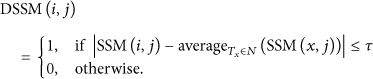
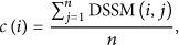
Due to hardware faults or external interference, the signal strength of tags may be erroneously read by RF reader. In the practical measurement, we observe that some tags' signal strengths read by readers are too large or too small, or zero (fail to read). Therefore, the signal strength of the reference tags is not trustworthy and needs to be verified before they are chosen for the tracking tag's location calibration.
With the placement of the reference tags and the readers shown in Figure 1, we can observe that a reference tag's signal strength is
always similar to its neighbor's for the same reader. Therefore, with known signal strength
of all reference tags, we can check whether the measurement is proper or not. Suppose we have
n RF readers

Placement of RF readers and tags.
Here, N is the set of

As an example in Figure 1, the set of
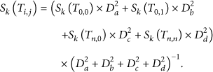
3.2. Nonlinear Interpolations
The concept of virtual reference tags can increase the precision of position estimation without additional cost. However, the VIRE algorithm calculates the virtual tags' signal strength by a simple linear method, which does deteriorate the performance of interpolation. To further improve the positioning precision, we apply a simple nonlinear interpolation in the solution model.
As shown in Figure 2, the real reference tags
in our approach are also properly placed to form a 2D regular grid. Each physical grid cell covered
by 4 real tags is further divided into

Nonlinear interpolation.
The RSSI values of those virtual tags are a function related to the signal strength of 4 real
reference tags in corner and can be obtained by the empirical formulas shown below:
Here,
3.3. Weight of Reference Tags
The proximity map is also used to eliminate those unlikely positions in the NICoT. When the
interpolation and elimination processes are finished, we can obtain a set of possible positions. To
improve the accuracy and robustness of NICoT, one weighting factor

Here,

When we compute the coordinate of a tracking tag, the weighting factors should be considered. We
suggest an assorted weight

Here, k is the number of total regions in the set of possible positions and
4. System Implementation and Simulation Evaluation
4.1. System Implementation
We use the simulation programs run in MATLAB to evaluate the performance of NICoT in an idealized
network environment. The experiment environment is illustrated in Figure 3. In our environment, 16 real reference tags were set in

Experiment environment.
4.2. Effect of the Density of Virtual Reference Tags
Figure 4 shows the effect of the number of
virtual reference tags on the estimation error when

Estimation error of the 9 tracking tags.
4.3. Performance Comparison Using Different Parameters
Figure 5 shows that different threshold
τ has different estimation error. We can see that the cumulation of
estimation error under different choices of τ increases with the increase of
error. We also note the estimation error is minimum, when

Estimation error of the 9 tracking tags.
4.4. Performance Comparison Using Different Localization Algorithms
Figure 6 shows the comparison between the NICoT approach and the VIRE approach for 9 different locations of the tracking tags. The reduction in estimation error for NICoT is from 43.6% to 62.8% over VIRE for all 9 locations. For those tags, the worst estimation error is 0.228 m and the average estimation error is 0.14 m. Clearly, the NICoT approach provides a higher degree of accuracy than that of VIRE at all locations.

Cumulative percentile of error distance.
5. Conclusion and Future Work
This paper presented an improved algorithm based on nonlinear interpolation of the virtual reference tags' signal strength and the concept of the reference tags' credibility. Compared with the VIRE algorithm, we apply a nonlinear interpolation method to further improve the positioning precision. We also introduce the concept of credibility of reference tags to reduce the influence of abnormal tags on positioning precision. It can be used for real-time indoor locating. Obviously, the proposed algorithm can be easily extended to the three-dimensional space. In future research, we may combine our algorithm with other location algorithms to further improve the positioning accuracy.
Footnotes
Acknowledgments
This work was supported by NSF of China under Grant nos. 61202452, 61202450, and 61202451 and the CEEUSRO projects of Fujian Province Education Department (no. JA12063).