
Abstract
It is very important to detect a collapse hole for coal mine workers. The possibility of detecting the collapse hole using WSN is presented because the tunnel in coal mine is narrow and has poor working condition. Comparing three types of the hole detection methods, it is seen that the connectivity-based methods are used to detect coal mine collapse better than other methods. By establishing a 2D model of the collapse hole in coal mine, a class of algorithms for detecting the collapse hole in coal mine is described. Based on log-normal shadowing channel model, the accuracy of detecting the collapse hole in coal mine using Fisher information is analyzed. Numerical calculation shows that connectivity-based localization schemes are better to detect collapse hole of coal mine.
1. Introduction
Coal mine collapse is one of the main reasons of coal mine fatalities in the past 10 years in the world [1]. Hence, it is very important to detect a collapse hole and accurately provide location references for coal mine workers. Since the coal mine collapse may destroy some coal safety monitoring devices, detecting the collapse hole in coal mine becomes a great challenge. The utilization of wire sensors to monitor coal mine is the primary method at present. However, the wired method makes the monitoring systems less scalable and vulnerable because of poor working conditions in the tunnel of coal mine. Once coal mine collapse happens, all wired sensors may be destroyed, and it is impossible to detect the collapse hole.
Wireless sensor network (WSN) is an event-based self-organized wireless network that relies on deploying spatially dense sensor nodes observing a physical phenomenon [2, 3]. Compared with traditional wire sensing, WSN can achieve larger coverage area, greater accuracy, and more flexible deployment. The utilization of WSN to monitor coal mine is of benefit. Once coal mine collapse happens, not all sensor nodes of WSN are destroyed. So, it is possible to detect the collapse hole in coal mine. For example, Li and Liu present a method based on a regular beacon strategy to detect the collapse hole in coal mine by regulating a mesh sensor network deployment [1].
When a collapse happens, the group of destroyed sensor nodes in the coal mine wireless sensor network creates a hole [4]. The collapse hole boundary separates all the faulty sensor nodes from the working nodes. Generally, there can be three types of the hole detection methods. The approaches based on geometric location methods [5, 6] rely on the nodes having geographical locations and can find more accurate boundary nodes than the other two methods, but each node has to be equipped with an extra device such as GPS to obtain the geographical locations. Unlike above approaches, the statistical methods [7, 8] without location information usually assume the sensor nodes are uniformly distributed on the sensing field. The major weakness of the statistical methods is that the criteria for detecting hole acquired from the statistical characteristics cannot guarantee to find hole precisely. The connectivity-based methods [9–11] use the information of neighboring sensor nodes connectivity to detect the hole. Normally, the method has higher packet control overhead than the previous two methods due to having to collect information from neighboring sensor nodes. However, it does not need location information and has better accuracy of finding boundary nodes than the statistical method. The sensor nodes neither can be equipped with any additional devices such as GPS nor are uniformly distributed because of the narrow tunnel and the poor working conditions of it in coal mine. So, the connectivity-based methods are used to detect coal mine collapse better.
Connectivity is just a binary variable determined by whether or not a sensor node can demodulate and decode a packet transmitted by another sensor node. Connectivity measurements can be obtained by comparing the received signal strength (RSS) value between the two nodes against a power threshold. The RSS can be used to implement range-based localization [12]. The localization methods are popular because no additional hardware is required on the sensor nodes. However, the range estimates using RSS are inaccurate and can lead to large localization error because the RSS value is affected by unpredictable shadowing and fading in the tunnel in coal mine. Yet connectivity is the binary variable carrying information regarding sensor nodes location and is often discussed without considering the effect of shadowing and fading channel. So, the connectivity-based methods for localization have been actively researched in hole detection and ad hoc routing in WSN [13–15].
Connectivity measurements are actually just a binary quantization of the RSS measurements against a power threshold. Because RSS measurements are affected by unpredictable shadowing and fading in the tunnel in coal mine, it is very important to analyze accuracy of detecting the coal mine collapse hole using the connectivity-based methods. The rest of this paper is organized as follows. Section 2 discusses the system models including a hierarchy WSN topology in coal mine underground and 2D model of the coal mine collapse hole. Section 3 introduces a class of algorithms for detecting the coal mine collapse hole using the connectivity-based methods. Section 4 analyzes the accuracy of detecting collapse hole using Fisher information. Section 5 presents numerical calculation and discussion. Section 6 concludes this paper.
2. System Models
2.1. A Hierarchy Underground WSN Topology in Coal Mine
In view of the characteristics of narrow and poor environment in coal mine underground, it is better to use the hierarchy WSN topology for improving coverage and connectivity [16, 17]. The hierarchy WSN comprises sensor nodes, relay nodes, and sink nodes. The sensor nodes gather methane data autonomously. Multisensors form a cluster, and the cluster heads are the addresses of relay nodes. Methane data collected by the sensor nodes are forwarded to sink nodes through relay nodes. Communication between relay nodes forms a multihop route, and monitoring data are processed at sink nodes. Finally, the gateway passes the data processed at sink nodes to methane monitoring center. Table 1 shows the various types of nodes in the hierarchy WSN. These nodes will form a hierarchy that is shown in Figure 1.
Types of nodes in hierarchy WSN in coal mine underground.


Hierarchy of nodes in an underground WSN in coal mine.
2.2. 2D Model of Coal Mine Collapse Hole
Generally, the tunnel of coal mine can be classified as arch-shaped, rectangle, trapezium, or semicircle tunnel. For convenience, we consider the rectangle tunnel in this paper. A cluster of sensor nodes are deployed on the walls and roofs of the tunnel, as shown in Figure 2(a). To facilitate collapse hole detection, Figure 2(a) can be unfolded to a 2D representation as depicted in Figure 2(b).

A cluster of sensor nodes deployment.
Comparing Figure 2(a) with Figure 2(b), the relationships between the neighboring sensor nodes in Figure 2(b) are the same as in Figure 2(a). However, the distance between any two nodes in Figure 2(b) is greater than or equal to the distance between the pair in Figure 2(a). Thus, the real connectivity of the WSN is no less than shown in the 2-D representation in Figure 2(b), and the accuracy of the collapse hole detection in Figure 2(b) is preserved in Figure 2(a).
So, a cluster of sensor nodes are modeled as a 2D graph,

A collapse hole created by damaged sensor nodes.
3. Algorithm for Detecting Collapse Hole Using Connectivity
Connectivity simply reports whether or not a sensor node can demodulate and decode a packet transmitted by another sensor node. Connectivity measurements can be obtained by comparing the received signal strength (RSS) value between the two nodes against a power threshold. Because the RSS measurements are affected by unpredictable shadowing and fading in the tunnel in coal mine, the connectivity can be described by a random binary variable

where
The connectivity-based methods will use the assumption that two sensor nodes are “connected” if
Step 1 (initialization).
Each sensor node broadcasts a ping requesting information to neighboring sensor nodes. If
Step 2 (integrity checking).
If a coal mine collapse occurs, each sensor node pings its neighboring sensor nodes, keeps track of the responses, and compares the list of neighboring sensor nodes. If
Step 3 (collapse hole scanning).
According to the list of sensor nodes marked as “on the collapse perimeter,” the classical Graham algorithm [19] is used to detect the collapse hole with convex hulls.
4. Accuracy of Detecting Collapse Hole
As shown in Section 3, analyzing the accuracy of detecting collapse hole using connectivity is equivalent to analyzing the accuracy of estimating distance d between neighboring sensor nodes equivalently using
4.1. Channel Model
Because the tunnel is narrow and the environment is poor in coal mine, the RSS is attenuated by path losses, fading, and shadowing losses [20]. Path loss is the deterministic reduction function of distance d between neighboring sensor nodes. Fading is the effect of multipath propagation. Because many wireless sensor nodes use spread-spectrum techniques, the fading can be reduced mostly and its impact on the attenuated RSS is not significant. Shadowing is the loss incurred as a signal passes through permanent obstructions (e.g., walls or buildings). For most sensor nodes in the tunnel, shadowing losses cannot be countered. When a collapse occurs, shadowing losses are greater. So, the RSS values follow the log-normal shadowing model, a channel model widely used in WSN [21, 22].
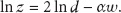
Let

where w is a zero-mean random variable with normal distribution
4.2. Fisher Information
In this paper, we focus on estimating distance d between neighboring sensor nodes from connectivity measurements, which carry information regarding sensor nodes location. As is well known, the Fisher information measures the amount of information that a random variable carries about an unknown parameter. And the inverse of the Fisher information, known as the Cramer-Rao Bound, is the minimum variance for any unbiased estimator. Here, the random variable
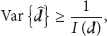
where
4.2.1. Fisher Information of RSS Measurements
For notational convenience, we define

Then, (2) can be written as

So, the underlying estimation problem is to estimate d from the RSS measurements z satisfying (5), given the knowledge of α and
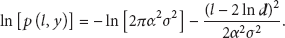
Taking the logarithm of (5), we obtain
Let
The log-likelihood function is given by
Taking the derivative of the log-likelihood function, we obtain

Hence, the Fisher information of RSS measurements is given by
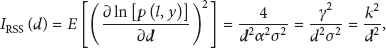
where
4.2.2. Fisher Information of Connectivity Measurements
As shown in Section 3, the underlying estimation problem is to estimate d from the connectivity measurements. Then the Fisher information of connectivity measurements depends not only on d between neighboring sensor nodes, but also on the value of the power threshold

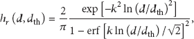
From [25], consider the case of 2-level quantized RSS. The Fisher information of connectivity measurements is given by

where the term
where
5. Numerical Calculation and Discussion
To analyze the accuracy of detecting collapse hole based on connectivity measurements, we examine the Fisher information using numerical calculation in this section.
5.1. Numerical Calculation
In this subsection, we investigate the Fisher information
5.1.1. The Path Loss Exponent's Effects on the Fisher Information
Figure 4 shows that

Fisher information for RSS measurements at fixed σ value.
Figure 4 describes that the amount of the
5.1.2. The σ Values’ Effects on the Fisher Information
Figure 5 shows that

Fisher information for RSS measurements at a fixed γ value.
Figure 5 describes that the amount of
5.1.3. The k Values’ Effects on the Fisher Information
Figure 6 shows that

Fisher information for connectivity measurements at different k values.

Fisher information for connectivity measurements at different d values.
Figures 6 and 7 describe that
5.2. Discussion about Accuracy of Detecting Collapse Hole
As shown in Section 5.1, RSS measurements carry greater Fisher information than connectivity ones. However, this is only true as long as the neighboring sensor nodes are within the radio coverage of each other. When sensor nodes are within each other's radio coverage, they are able to communicate and successfully exchange radio message.
Depending on the choice of
As shown above, RSS range-based localization schemes are more accurate when the neighboring sensor nodes are in the radio coverage of each other, but connectivity-based localization schemes are naturally suited to localize nodes that are far from radio coverage. Hence, connectivity-based localization schemes are used to detect collapse hole of coal mine better.
6. Conclusion
It is very important to detect a collapse hole for coal mine workers. This paper presents the possibility of detecting the collapse hole using WSN. Comparing three types of hole detection methods, we think that the connectivity-based methods are better to detect coal mine collapse. By establishing a 2D model of the collapse hole in coal mine, we describe a class of algorithms for detecting the collapse hole in coal mine. Based on log-normal shadowing channel model, we analyze the accuracy of detecting the collapse hole in coal mine using Fisher information and make numerical calculation. Finally, we make the conclusion as follows.
The larger the path loss exponent, the greater the Fisher information.
The larger the variability caused by the RF shadowing, the less the Fisher information.
When sensor nodes are within each other's radio coverage, the accuracy of detecting the collapse hole using RSS measurements is higher than that when using connectivity ones; when the neighboring sensor nodes are far from radio coverage, no RSS information can be collected, and
Footnotes
Acknowledgments
The authors wish to thank the editor and reviewers for their valuable comments, corrections, and suggestions, which led to an improved version of the original paper. This research is a project partially supported by the National Natural Science Foundation of China (Grant no. 61064614), Guizhou Science and Technology Innovation Group for RFID & WSN, and Guizhou Natural Science Foundation (Grant no. [2012] 38).