
Abstract
Most strategies for addressing environmental and climate injustices in the United States are predicated on strong local governance tools, oftentimes tied to land use and zoning. There is, however, no right to local governance in the United States—a serious issue considering an estimated one-third of residents live in unincorporated areas. As a result, many unincorporated communities struggle to receive adequate stormwater management, particularly in the face of climate change. In this article, the effects of unincorporated status are examined in relation to (in)equitable access to stormwater management in the Lower Río Grande Valley of South Texas. Within this region, low-income unincorporated communities known as “colonias,” unincorporated neighborhoods along the U.S./Mexico border that historically lack access to basic services and infrastructure, form the primary focus of this case study. Recently, several major rainstorms provoked the Texas Water Development Board to identify the scope and source of colonia flooding through a flooding survey. Evaluating this assessment against interviews and participant observations from 2014 to 2020, the source of flood injustice in rural communities emerges as limited available flood mitigation strategies, consistent “no's” from government agencies at all levels, and complex flooding sources complicating equitably addressing flood risks. From this case study, the article suggests how planners and policymakers can provide a path forward to equitably protect unincorporated low-income communities from risks and hazards. Primarily, the lack of mitigation strategies for unincorporated communities constitutes a major injustice when addressing environmental risks and hazards.
INTRODUCTION
Stormwater management strategies are largely derived from and aimed toward cities with strong local governance. 1 Although cities and towns—incorporated areas—may have the resources and wherewithal to pursue natural hazards mitigation, an estimated 30% of U.S. residents lived in unincorporated areas that, state-by-state, lack fundamental access to these systems of support. 2 Further compounding this gap, dominant theories of rurality in planning and policy have historically prevented an in-depth accounting of the barriers to rural hazard mitigation; contemporary theories cast rural communities as operating in deficit (assuming resource scarcity). Emerging theories of rural capacity point instead to the need for context appropriate practices that emphasize the distinctness of rural governance and policy, with the capacity to open new paradigms for hazard mitigation. 3
Building upon new theories of rural planning, this article considers the case of the Lower Río Grande Valley (LRGV) in South Texas, a tri-county region of South Texas adjacent to the U.S./Mexico border and the Gulf of Mexico, including Hidalgo, Cameron, and Willacy counties (Fig. 1). Within this region, rural low-income communities, known as “colonias,” frequent experience flooding and lack of access to basic services and infrastructure. Although elevated colonia flood risk has been identified in the literature and in colonia policies since the 1990s, only in the past 15 years (since Hurricane Dolly) 4 has there been concerted attention given to addressing this issue. This recent organizing movement, increasingly known across Texas as “Flood Justice,” has won several concessions, particularly in compelling and assisting a 2014–2016 Texas Water Development Board (TWDB) survey of LRGV colonia flood risk.

Map showing the location of the Lower Rio Grande Valley and the location of its colonias.
In this study, the results of this flood survey 5 are examined geospatially and through qualitative content analysis alongside interviews with 30 colonia organizers conducted between 2014 and 2020 to elucidate the policy and planning barriers to flood justice. This case study highlights the protracted struggles that impoverished rural communities experience across the United States when attempting to mitigate flooding; in particular, three core issues are examined in the discussion. I then close with several recommendations for how these issues could be addressed to promote full and equitable access to stormwater management in low-income rural communities.
BACKGROUND OF THE CASE
Colonias first emerged in the 1960s when the Bracero program brought migrant farmworkers to the LRGV. 6 However, as workers arrived in the region, cities and towns refused to build affordable housing, instead pushing migrant farmworkers into unincorporated rural areas of the LRGV. These early incarnations of the colonias emerged through the subdivision of agricultural lands by rural landowners—plots of land were sold to households without a house with the promise of basic services and infrastructure that frequently never materialized. 7 As a result, colonia residents found themselves with unserviced land, far from incorporated cities, and with no house. Although this often casts colonias as “informal,” synonymous for “illegal” in the United States, colonias are technically extralegal, existing at the edges of what is permissible by law. 8
For decades, colonia residents organized for adequate housing and services, but they did not begin receiving political recognition in Texas until the late 1980s. In 1987, Texas enacted its first colonia policy, SB585, which authorized the TWDB to administer grants and services for improved water and wastewater services in colonias. Two years later, SB2 created the Economically Distressed Areas Program to provide water and wastewater services to colonia residents who could not afford them.
In 1995, two key policies were passed regarding colonia development and support. SB1509 generated “self-help centers” offering housing construction assistance to colonia households in nonprofit hubs, many of which still exist today. HB1001 “halted” the development of new colonias by placing restrictions on rural subdivisions without platting and basic services, although the practice persists. 9 Key in these early colonia policies is a focus on housing quality and access to water and wastewater management—but notably not stormwater management. Colonia infrastructure improvements were not even tracked until 2005 when SB827 established the Colonia Classification System 10 —the first governmental effort to track the lack of drainage in colonias.
Drainage became more urgent in 2008 when Hurricane Dolly made landfall in the LRGV, causing flooding across the region's colonias and leaving standing waters in some colonias that lingered for 180 days. 11 Hurricane Dolly significantly shifted the priorities of colonia residents and organizers in its wake, placing “colonia flooding” as a significant concern on resident surveys ever since. 12 In the intervening years since Dolly, the LRGV has been repeatedly drenched by other hurricanes—in 2020, Hurricane Hanna struck the region, again causing widespread flooding and lingering floodwater. Even in colonias with some stormwater management, such as drainage ditches, organizer interviews show that colonia residents were forced to take turns removing debris from ditches to keep the limited infrastructure functional. 13
Despite their dramatic primacy, however, hurricanes and tropical storms are not the only weather hazards in this region—lingering and long-standing rainstorms pose even greater threats. In 2018, the “Great June Floods” resulted from days of sustained rainstorms, which dropped an estimated 12–18 inches of rain between June 18 and 22. 14 In the end, the Great June Flood proved more damaging than Hurricanes Dolly or Hanna. 15 Much like tropical storms, these slow-moving rainstorms are projected to increase in frequency in the LRGV with climate change, lending further urgency to the task of addressing flood risk in the coming years. In 2020, Texas was compelled to expand the TWDB's colonia programs to include drainage.
Persistent flooding also led to concerted organizing efforts for flood justice in LRGV colonias. Beginning in the early 2010s, design nonprofit bcWORKSHOP worked in concert with local colonia-based organizations to launch the Land Use Colonia Housing Action (LUCHA) program. LUCHA used Freirian concepts of education as organizing to teach colonia residents about stormwater management, how it should operate, and why it fails in colonias. This new knowledge encouraged residents to organize for improved drainage through marches, letter-writing campaigns, and engagement with public officials. However, although these efforts led to widespread organizing, several governance barriers persist to equitably addressing colonia flooding.
THEORETICAL FRAMEWORK
Colonia flood risk presents a specific instance of a broader problem: inequitable access to rural stormwater management. Contemporary scholarship on rural planning and policy asserts that planning practice cannot adequately persist in a “rural deficit” approach, considering rural communities as “residual” areas between cities. 16 Deficit-based approaches instill unequal access to infrastructure in unincorporated areas by asserting, upfront, that rural communities operate under resource scarcity. This formulation definitionally centers incorporated areas, leaving unincorporated areas to act “opportunistically rather than strategically.” 17
Practically, the absence of municipal governance carries real implications for rural communities: land use and zoning tools are primarily designed for incorporated areas in the United States, as demonstrated by the general paucity of large-scale land use planning. In other words, land use policy is a “local” undertaking, using “local” tools. 18 Unfortunately, land use and zoning underpin many strategies and tools for hazard mitigation in planning.
Contemporary flood mitigation and adaptation techniques emphasize “best practices” suited for municipal-level implementation. 19 Rural communities were found to have lower quality hazard mitigation plans that followed templates designed for urban areas, disallowing a context-appropriate approach. 20 This results in further inequities in federal post-disaster assistance, with urban communities receiving the bulk of support, whereas rural communities are expected to “rebuild themselves.” 21 Funding for rural hazard mitigation and adaptation may even be declining in recent decades, whereas funding is increasing in urban areas. 22 Despite this division, rural areas are inextricably linked to their urban neighbors. Mitigation and adaptation not occurring in rural areas holds implications for adjacent urban areas. 23
Instead of a deficit-lens, rural communities, similar to colonias, benefit from context-appropriate approaches to hazard mitigation and adaptation. In particular, Frank and Hibbard advocate for rural planning that “holistically understand and value specific rural places, empower their residents, and coordinate their constituencies.” 24 The context-appropriate approach refers to a real mode of governance where communities lack municipal (local level) representation and, therefore, are governed fundamentally differently than areas with strong local governance. A “governance” definition of rural planning, then, evaluates the impacts special districts and extraterritorial zones—areas extending government services beyond local jurisdictional boundaries—on hazards planning. 25 This definition aligns with disaster scholarship, centering “place” as a core factor in determining risk. 26 Risk, here, is defined following Andrew Rumbach as “…not a natural outcome of urbanization but […] socially, politically, and economically constructed.” 27
Aligning definitions of “rural” and “risk” with local socioeconomic and sociopolitical structures extends discussions of inequitable rural access to hazard mitigation and adaptation beyond “disparities” studies, which, although crucial, often do not ascertain why these vulnerabilities exist and persist. Elsewhere, I examine this concern relative to the processes of undertaking hazard mitigation and adaptation as “procedural vulnerabilities.” 28 Procedural vulnerabilities are historical and ongoing power relations generating inequitable outcomes in disaster recovery and reconstruction processes. 29 Using a context-appropriate approach for examining flood risks, I elucidate how governance structures, stemming from rurality, impact access to flood mitigation and adaptation in LRGV colonias. This approach, then, seeks to uncover the structures exacerbating flood risks, as opposed to amplifying erroneous deficit-centered narratives of colonia capacity.
CASE STUDY DESIGN
The case study analyzed data from both a 2014–2016 TWDB flood risk survey and community interviews. In their survey, TWDB uncovered numerous procedural barriers to addressing colonia flooding, corroborated by interviews with colonia organizers. 30 The author has conducted long-term research in LRGV colonias stretching back over 10 years. Encouraged by colonia residents affected by flooding, the author conducted interviews with 30 colonia organizers and advocates, and undertook participant observations of community events from 2014 to 2020. Geospatial analyses were undertaken in ArcGIS Pro (spatial data) and Atlas.TI (qualitative content analysis) for these data sources.
The results were reported back to the residents and their grassroots organizations as a professional report entitled Colonia Flooding: An Institutional Analysis for the LRGV. 31 The report's data analysis was partially funded by a University of Colorado Boulder Program in Environmental Design Seed Grant. In this study, the results of this report (designed to assist organizing for flood justice in LRGV colonias) is more broadly examined relative to emerging literature on rural environmental planning. The findings here remain generalizable to U.S. states that permit unincorporated territories.
CASE STUDY RESULTS
The TWDB survey undertook flood risk analyses in 78 of the LRGV's estimated 988 colonias. TWDB attempted to provide analyses for as many colonias as possible, identifying 100 high-priority colonias; however, funding restrictions limited their survey to 78 colonias. TWDB thus established prioritization criteria to identify colonias with the highest flood risk, examining three categories of information:
Jurisdictional boundaries: Only examining colonias outside of a city or city's extraterritorial jurisdiction (ETJs). Existing flood data: Examining historic flood patterns, flood plain boundaries, and soil/terrain analyses to identify regionally flood-prone areas and their colonias. Infrastructure planning documents: Identifying proposed and existing stormwater management projects to prioritize colonias with no proposed or existing infrastructure.
TWDB geospatially analyzed these criteria to create a prioritization list of colonias to survey, then undertook flood modeling for 2-, 5-, 10-, 25-, and 100-year flood events, examining where roadways, lots, and structures might flood in each colonia, finally proposing physical projects and policy changes to address the risks. In these analyses, TWDB found not all colonias experience the same sources of flooding, undoing a long-standing assumption that their flood risk is due to their historic subdivision from agricultural lands, which were initially graded to retain water near crops.
Instead, the TWDB's survey found that this development history may only hold true for ∼27% of LRGV colonias, 32 leading to concerns that flooding in this region originates from a wider variety of sources. Ultimately, TWDB found that colonia flooding is not inherently part of colonia urban form and may be caused by a plethora of problems: elevated roadways blocking drainage, uncertain jurisdiction, and so on. TWDB emphasized two main flood conditions, those emanating from (1) external sources (e.g., lack of connections to regional drainage systems) and (2) internal sources (e.g., lack of proper outflows).
In cross-examining TWDB's data with accounts from colonia organizers and advocates, the conditions identified by the TWDB related only to one of three core issues restricting equitable access to flood mitigation and adaptation in LRGV colonias: (1) unincorporated status greatly restricts access to flood mitigation and adaptation strategies; (2) communities are stuck between various levels of government, what we call the “Scales of ‘No’”; and (3) the former issue leads to varying sources of flooding, resulting in a variety of approaches needed to mitigate the risk.
Limited scope of available strategies
TWDB Report 2 lists proposed interventions for each of the 78 colonias surveyed. These strategies were coded and analyzed against a typology of recognized green and gray infrastructure strategies for mitigating flooding (Fig. 2), and it became evident that TWDB remained largely restricted to gray infrastructure strategies. Drainage ditches and retention ponds were proposed, respectively, 83.3% and 80.5% of the time in TWDB's plans. The only green infrastructure strategy proposed was bioswales (in 46.8% of the plans).
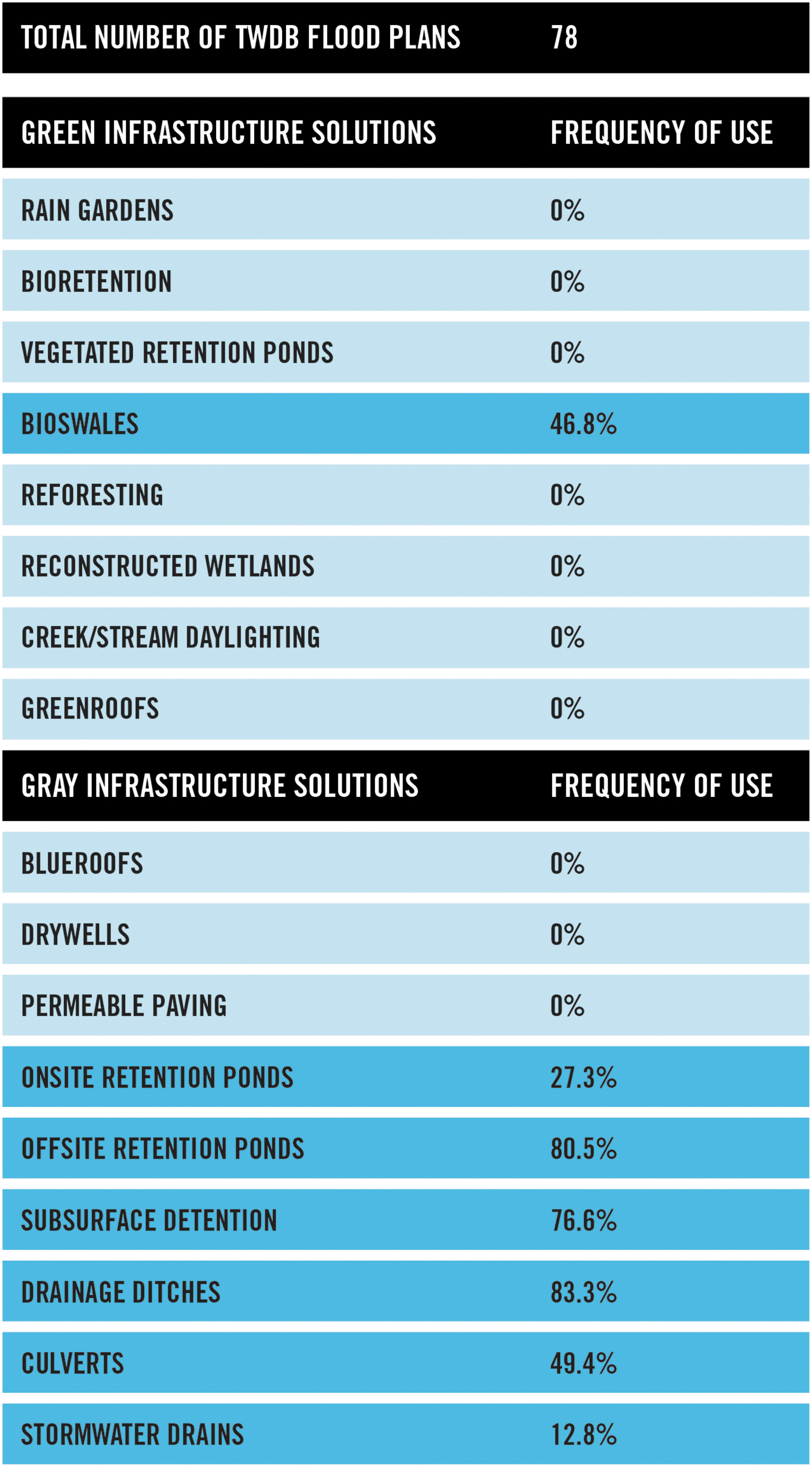
Diagram showing the frequency in which the TWDB suggests various green and gray infrastructure strategies. TWDB, Texas Water Development Board.
This limited scope of strategies presents several concerns. First, despite their popularity with residents and organizers, 33 multiuse spaces and greenspaces were not options available to the TWDB. Second, TWDB is hampered by cost-benefit analyses that disadvantage green infrastructure and nature-based solutions due to their high upfront costs, despite their potential long-term maintenance cost savings. 34 Accurate cost-benefit analyses remain particularly intractable in rural communities whose “benefit” remains difficult to quantify over the long term.
Scales of “No”
We'd go to meetings with our elected officials, and explain what our needs were. But they would just say, “No, that's not our jurisdiction. You need to go talk to someone else.” Eva Carranza, colonia resident, quoted in the Texas Observer 35
As Carranza's quote illustrates, there exists a web of jurisdictions from the local to federal levels, each of which may refuse assistance to rural low-income communities—what I call the “Scales of ‘No.’” These “no's” emerged consistently in interviews and community meetings over the years: it remains unclear who bears primary responsibility for mitigating rural flood risk.
At the local level, an estimated 68% of LRGV colonias reside in ETJs of local cities. 36 In Texas, ETJs are contiguous unincorporated areas immediately outside a city's jurisdictional boundary (at varying distances) that can be leveraged as “growth boundaries.” 37 Unfortunately, the extent to which Texan cities are required to build and maintain stormwater management systems in their ETJs remains unclear, causing conflicts between cities and counties as they pass the responsibility. Durst notes that, for housing quality, cities often remain uncertain which regulations can be extended in their ETJs, resulting in poor colonia housing quality despite their city proximity. 38 For the 32% of colonias outside of city ETJs, their only recourse is to compete with well-resourced cities for the attention of county officials.
At the state level, county officials often wish to assist rural communities but are (or perceive themselves to be) ill-equipped to undertake stormwater management in unincorporated areas. Colonia organizers have successfully worked with county officials in the past. In the fight for colonia streetlights, organizers convinced county officials to join their Right to Light campaign throughout the 2010s, lobbying together in Austin, TX for county rights to tax for, install, and maintain streetlights in unincorporated areas. 39 However, when these same organizers sought county support for stormwater management, officials said “no,” feeling ill-equipped and too under-resourced to undertake stormwater management in colonias. This state-level scope of “No” is, perhaps, the greatest barrier to addressing rural flood risk.
At the (inter)national level, TWDB noted significant disconnections between domestic systems and the heavily regulated International Boundary & Water Commission (IBWC) a binational agency established in 1889 between Mexico and the United States to govern the Río Grande. In the LRGV today, the IBWC controls water flows through a series of border levee walls along the Río Grande. These levees contain floodgates designed to shut in major rainstorms and hurricanes to prevent the Río Grande from inundating the region. However, closing of floodgates prevents regional waterways from draining into the Río Grande without costly water pumps, which some areas lack, to pump the stormwater over the levees. In the wake of hurricanes, Río Grande floodgates can remain shut for weeks or months, as the IBWC waits for the Río Grande to reach safe levels, leading to a preponderance of retention and detention ponds throughout the region. Without addressing this issue, the whole LRGV region faces flood injustices, not just its colonias.
CONCLUSIONS AND RECOMMENDATIONS
The case of LRGV colonia flooding illustrates several concerns for equitably addressing rural flood risks. First, we need a broader set of strategies for flood mitigation and adaptation considering rural communities. These strategies must contend with cost-benefit analyses that too frequently extinguish rural infrastructure initiatives, despite their wide-reaching potential impacts. Second, unincorporated status often leads to a scope of “No” if there is no regional or state agency specifically tasked with and resourced to address rural flooding. In the absence of an unequivocable charge to address stormwater issues, an incentive emerges to pass the responsibility between institutions, generating procedural inequities across multiple environmental programs. For rural communities such as the colonias, county government and/or ETJ laws provide the clearest ways forward.
In the wake of climate change rural areas remain highly vulnerable to flooding due to deficit narratives barring their meaningful inclusion in mitigation and adaptation planning. As in the case of LRGV colonias, much of the resources and tools for addressing flood risk are directed toward incorporated cities, systemically omitting rural areas from addressing these risks. To instill flood justice in communities such as the colonias, planners and policymakers need to acknowledge that these risks exist in rural communities, specifically rural communities of color face additional barriers to meaningful inclusion in mitigation and adaptation. Finally, planners and policymakers need to develop programs and strategies to assist rural communities in meaningfully participating in flood mitigation and adaptation, which take their precarious positioning into account.
Footnotes
ACKNOWLEDGMENTS
The author thanks the following students for their assistance with the analyses of the strategies listed in ![]() : Constantine “Dean” Chrisafis and Kaylan Julien. She also thanks the following researchers for reviewing part or all of the professional report upon which this article is built: Edna Ely-Ledesma, Bara Safarova, Alejandra Reyes, and Noah Durst.
: Constantine “Dean” Chrisafis and Kaylan Julien. She also thanks the following researchers for reviewing part or all of the professional report upon which this article is built: Edna Ely-Ledesma, Bara Safarova, Alejandra Reyes, and Noah Durst.
DISCLAIMER
The author confirms sole responsibility for the following: study conception and design, data collection, analysis and interpretation of results, and article preparation.
AUTHOR DISCLOSURE STATEMENT
No competing financial interests exist.
FUNDING INFORMATION
No funding was received for this article.